


Intelligent Recognition and Feature Analysis of Seismic Surface Cracks Integrating Multi⁃Scale Features and Attention Mechanism: A Case Study of the 2025 Dingri, Xizang MS6.8 Earthquake
-
摘要:
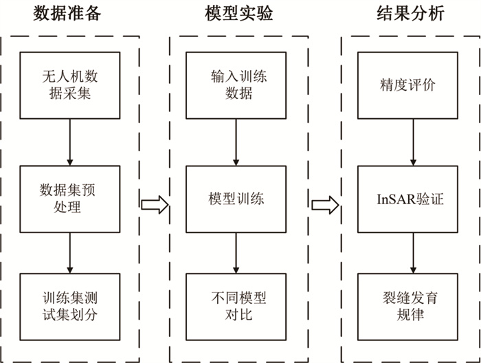
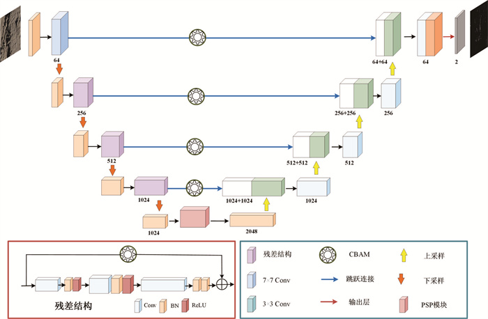
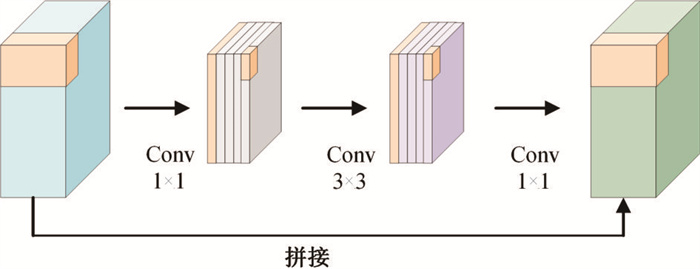
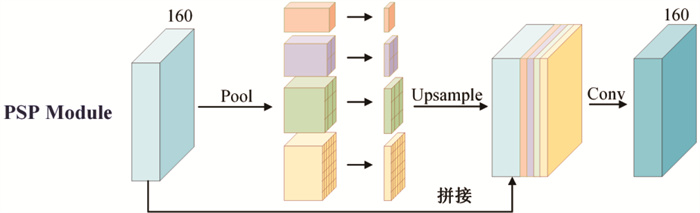
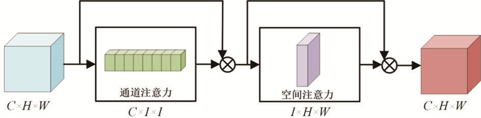
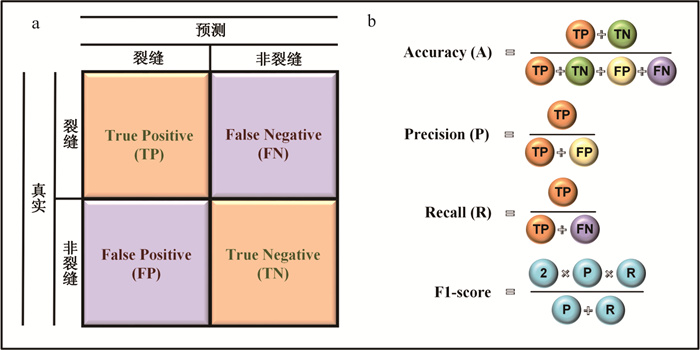
地震引发的地表裂缝对于揭示断层活动、解析地震构造特征以及震后灾害评估具有重要意义.本研究结合现场采集的高精度无人机(UAV)数据和深度学习技术,对2025年西藏定日MS6.8地震的地表裂缝特征进行了自动识别与分析,揭示了裂缝的走向规律,并与InSAR变形数据进行了对比验证.基于现场无人机(UAV)获取的高分辨率影像,构建ResPSP-CBAM模型进行智能识别,成功提取了震后区域的地表裂缝分布.该模型集成了ResUNet的残差结构、空间金字塔池化(PSP)模块和卷积块注意力机制(CBAM),显著提高了地表裂缝识别的精度与鲁棒性.分析结果表明,ResPSP-CBAM模型在准确率、精确度、召回率、F1分数上表现优越,其相应数值分别为0.927、0.829、0.779和0.802,识别出的地表裂缝走向与InSAR解译的地表变形方向高度一致,进一步验证了该方法的有效性.本研究构建的ResPSP-CBAM深度学习模型显著提高了地震地表裂缝智能识别的精度和效率.识别出的地表裂缝包含原生和次生裂缝,且主要以断层破裂引起的原生裂缝为主,总体呈南北走向分布,与登么错断裂带走向高度一致.表明识别区域地震地表裂缝与断层的活动性密切相关.本研究为地震地表裂缝的智能识别提供了新的技术手段,对深入理解震源断层的构造特征提供了有力支持,同时为地震预测、预警及震后灾害评估提供了重要的科学依据.
-
关键词:
- 地表裂缝 /
- 西藏定日MS6.8地震 /
- 无人机 /
- InSAR /
- 深度学习 /
- ResPSP-CBAM /
- 地质灾害
Abstract:Coseismic surface fractures triggered by earthquakes are of significant importance for understanding fault activity, seismic structural characteristics, and post-earthquake disaster assessment.This study combines high-resolution unmanned aerial vehicle (UAV) data and deep learning techniques to automatically identify and analyze the surface fracture characteristics of the 2025 MS6.8 earthquake in Dingri, Xizang, further revealing the surface fracture strike pattern and validating it through comparison with InSAR deformation data. Based on high-resolution images obtained by low-altitude UAVs, the ResPSP-CBAM model was used for intelligent recognition, successfully extracting the surface fracture distribution in the post-earthquake area. The ResPSP-CBAM model integrates the ResUNet residual structure, Pyramid Scene Parsing (PSP) module, and Convolutional Block Attention Mechanism (CBAM), significantly improving the accuracy and robustness of crack detection.The analysis indicates that the ResPSP-CBAM model performs excellently in accuracy, precision, recall, and F1 score, with respective values of 0.927, 0.829, 0.779, and 0.802. The identified surface fracture trends are highly consistent with the surface deformation directions interpreted from InSAR, further validating the effectiveness of this method.The ResPSP-CBAM deep learning model constructed in this study significantly improves the accuracy and efficiency of intelligent identification of seismic surface fractures. The identified surface fractures include both primary and secondary types, predominantly featuring primary fractures induced by fault ruptures. These fractures generally exhibit a north-south strike orientation, which aligns closely with the strike direction of the Dengmoco fault zone. This indicates that the surface fractures in the study area are closely associated with fault activity. This research provides a novel technical approach for intelligent identification of earthquake-induced surface fractures, offering robust support for understanding structural characteristics of seismic source faults, and delivering critical scientific evidence for earthquake prediction, early warning systems, and post-earthquake hazard assessments.
-
Key words:
- surface fracture /
- Dingri MS6.8 earthquake /
- UAV /
- InSAR /
- deep learning /
- ResPSP-CBAM /
- disasters
-
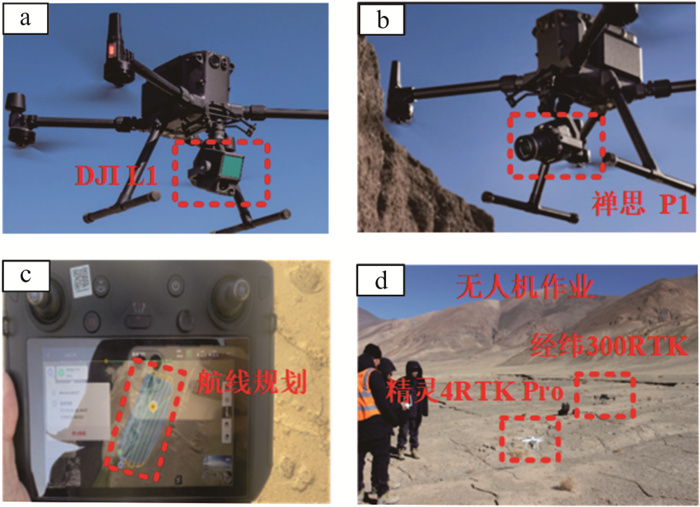
图 3 经纬M300 RTK野外飞行获取数据
a,b.无人机展示;c.航线规划;d.执行任务
Fig. 3. Field data acquisition with the DJI M300 RTK
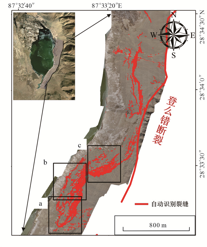
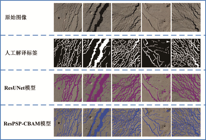
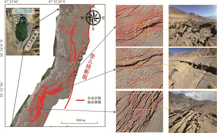
图 11 基于ResPSP-CBAM的地表裂缝自动识别效果图(整体)
Fig. 11. Automatic surface fracture identification results based on ResPSP-CBAM (overall)
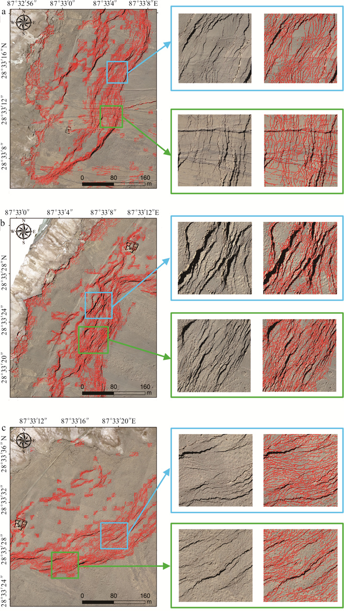
图 12 基于ResPSP-CBAM的地表裂缝自动识别效果图(局部)
Fig. 12. Automatic surface fracture identification results based on ResPSP-CBAM (partial)
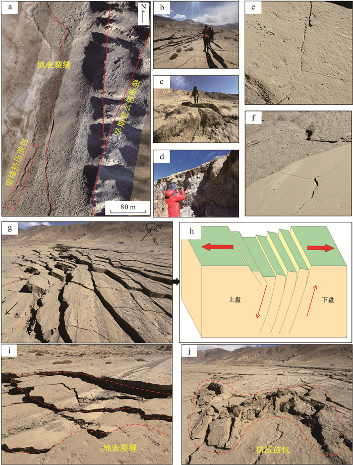
图 14 断层走向与地表裂缝特征
a.断层与裂缝走向;b,c,d. 野外现场调查;e,f. 细小拉张裂缝;g.阶梯状地表裂缝;h.断层错动示意图;i.地表裂缝;j.挤压鼓包
Fig. 14. Strike of fault and characteristics of surface fracture
表 1 无人机主要设定参数
Table 1. The main parameter set for the drone
参数 参数数值 飞行平台 经纬M300 RTK 搭载镜头 P1 L1 飞行高度(m) 100 120 飞行速度(m/s) 7.9 6 测绘面积(m2) 743 425.8 87 386.0 激光脉冲频率(kHz) -- 160 航向重叠率(%) 80 70 旁向重叠率(%) 70 50 影像地面分辨率(m) 0.05 0.05  下载: 导出CSV
表 3 模型识别结果
Table 3. Recognition results of network models
模型 准确率 精确率 召回率 F1分数 ResUnet 0.913 0.770 0.778 0.774 ResPSP-CBAM 0.927 0.829 0.779 0.802
下载: 导出CSV
-
Allégre, C. J., Courtillot, V., Tapponnier, P., et al., 1984. Structure and Evolution of the Himalaya-Tibet Orogenic Belt. Nature, 307(5946): 17-22. https://doi.org/10.1038/307017a0 Chen, J., Chen, Y. K., Ding, G. Y., et al., 2003. Surface Rupture Zone of the 2001 West Kunlun Mountain Pass M8.1 Earthquake. Quaternary Research, (6): 629-639, 717-718 (in Chinese). Chen, X. L., Hu, G., Liu, X. L., 2022. Recognition of Earthquake Surface Ruptures Using Deep Learning. Applied Sciences, 12(22): 11638. https://doi.org/10.3390/app122211638 Ding, L., Kapp, P., Cai, F. L., et al., 2022. Timing and Mechanisms of Tibetan Plateau Uplift. Nature Reviews Earth & Environment, 3(10): 652-667. https://doi.org/10.1038/s43017-022-00318-4 Dong, A. N., Dou, J., Li, C. D., et al., 2024. Accelerating Cross-Scene Co-Seismic Landslide Detection through Progressive Transfer Learning and Lightweight Deep Learning Strategies. IEEE Transactions on Geoscience and Remote Sensing, 62: 4410213. https://doi.org/10.1109/TGRS.2024.3424680 Dong, X. J., Wang, D., Feng, T., 2019. Research on the Application of Unmanned Aerial Vehicle Digital Photogrammetry in Landslide Disaster Investigation. Journal of Geological Hazards and Environment Preservation, 30(3): 77-84 (in Chinese with English abstract). doi: 10.3969/j.issn.1006-4362.2019.03.013 Dou, J., Xiang, Z. L., Xu, Q., et al., 2023. Application and Development Trend of Machine Learning in Landslide Intelligent Disaster Prevention and Mitigation. Earth Science, 48(5): 1657-1674 (in Chinese with English abstract). Dou, J., Xing, K., Wang, L. Z., et al., 2025. Air-Space-Ground Synergistic Observations for Rapid Post-Seismic Disaster Assessment of 2025 MS6.8 Xigazê Earthquake, Xizang. Journal of Earth Science, 1-18. https://doi.org/10.1007/s12583-025-0160-2 Du, C. Z., Duan, Y. X., Sun, Q. F., 2021. Seismic Crack Recognition Method Based on ResUNet and Dense CRF Model. Journal of Applied Sciences, 39(3): 367-377 (in Chinese with English abstract). doi: 10.3969/j.issn.0255-8297.2021.03.003 Gao, R., Lu, Z. W., Klemperer, S. L., et al., 2016. Crustal-Scale Duplexing beneath the Yarlungzangbo Suture in the Western Himalaya. Nature Geoscience, 9: 555-560. https://doi.org/10.1038/ngeo2730 Gao, Y. S., 2023. Research on Building Crack Recognition Technology Based on Deep Learning (Dissertation). University of Electronic Science and Technology of China, Chengdu (in Chinese with English abstract). Hao, X. Y., Zhang, Y. Z., Liu, J. J., et al., 2024. InSAR Coseismic Deformation Observation and Slip Distribution Inversion of the Türkiye Conjugate Earthquakes in 2023. Journal of Geodesy and Geodynamics, 44(5): 479-484, 509 (in Chinese with English abstract). He, K. M., Zhang, X. Y., Ren, S. Q., et al., 2016. Deep Residual Learning for Image Recognition. 2016 IEEE Conference on Computer Vision and Pattern Recognition (CVPR), Las Vegas, 770-778. https://doi.org/10.1109/CVPR.2016.90 Li, D. C., Ren, J. J., Zhang, Z. W., et al., 2022. Research on Semi-Automatic Extraction Method of Seismic Surface Ruptures Based on High-Resolution Uav Image: Taking the 2021 MS7.4 Maduo Earthquake in Qinghai Province as an Example. Seismology and Geology, 44(6): 1484-1502 (in Chinese with English abstract). doi: 10.3969/j.issn.0253-4967.2022.06.008 Li, Y. M., Zhang, Z. G., Zhang, H., et al., 2023. Quantitative Analysis of Paleoglacial Landforms Based on UAV LiDAR Technology: A Case Study of the Kuzhaori Moraine at the Southern Margin of the Daocheng Paleo- Ice Cap. Geological Review, 1-13 (in Chinese). doi: 10.3969/j.issn.0371-5736.2023.1.dzlp202301002 Li, Y. S., Li, W. L., Xu, Q., et al., 2025. InSAR Co- Seismic Deformation Detection and Fault Slip Distribution Inversion of the January 7, 2025 Dingri, Tibet MS6.8 Earthquake. Journal of Chengdu University of Technology (Natural Science Edition), 52(2): 199-211 (in Chinese with English abstract). Li, Z. M., Li, W. Q., Li, T., et al., 2021. Preliminary Investigation on Seismogenic Structure and Surface Rupture of the May 22, 2021 Maduo MS7.4 Earthquake in Qinghai. Seismology and Geology, 43(3): 722-737 (in Chinese with English abstract). doi: 10.3969/j.issn.0253-4967.2021.03.016 Liang, K., He, Z. T., Jiang, W. L., et al., 2022. Characteristics of Co-Seismic Surface Rupture of the January 8, 2022 Menyuan MS6.9 Earthquake in Qinghai. Seismology and Geology, 44(1): 256-278 (in Chinese with English abstract). doi: 10.3969/j.issn.0253-4967.2022.01.016 Liu, C., Du, P., Wang, Y., et al., 2021. Research on the Application of the Difference with or without Ground Control Points in Earthquake Based on UAV Photogrammetry Technology. South China Journal of Seismology, 41(1): 84-93 (in Chinese with English abstract). Liu, D. M., Wang, J., Jiang, H., et al., 2024. Dynamic Mechanism of the Formation and Evolution of the Tibetan Plateau and Its Remote Effects. Earth Science Frontiers, 31(1): 154-169 (in Chinese with English abstract). Liu, X. L., Xia, T., Liu, J., et al., 2022. Distributed Characteristics of the Surface Deformations Associated with the 2021 MW7.4 Madoi Earthquake, Qinghai, China. Seismology and Geology, 44(2): 461-483 (in Chinese with English abstract). doi: 10.3969/j.issn.0253-4967.2022.02.012 Shi, F., Liang, M. J., Luo, Q. X., et al., 2025. Seismogenic Structure and Co-Seismic Surface Rupture Characteristics of the January 7, 2025 Dingri, Tibet M6.8 Earthquake. Seismology and Geology, 47(1): 1-15 (in Chinese with English abstract). doi: 10.3969/j.issn.0253-4967.2025.01.001 Shu, P., 2023. Quantitative Study on the Latest Late Cenozoic Right-Lateral Strike-Slip Movement of the Tan-Lu Fault Zone and Its Tectonic Significance: Based on Structural and Sedimentary Constraints of the Banquan Pull-Apart Basin (Dissertation). Institute of Geology, China Earthquake Administration (in Chinese with English abstract). Sokolova, M., Lapalme, G., 2009. A Systematic Analysis of Performance Measures for Classification Tasks. Information Processing & Management, 45(4): 427-437. https://doi.org/10.1016/j.ipm.2009.03.002 Tan, S. S., Yang, Y. H., Xu, Q., et al., 2025. Characteristics of Surface Co-Seismic Deformation and Analysis of Building Damage in the January 7, 2025 Dingri County, Tibet MS6.8 Strong Earthquake. Journal of Chengdu University of Technology (Natural Science Edition), 1-11 (in Chinese with English abstract). Tie, Y. B., Gao, Y. J., Zhang, X. Z., et al., 2025. Research on Development Patterns of Geological Disasters and Mitigation Strategies in the MS6.8 Earthquake Area of Dingri County, Tibet. Sedimentary Geology and Tethyan Geology, 45(1): 212-224 (in Chinese with English abstract). Wang, N., Li, Y. S., Shen, W. H., et al., 2025. InSAR Inversion of Focal Mechanism and Rapid Simulation of Strong Ground Motion for the January 7, 2025 Dingri, Tibet MS6.8 Earthquake. Journal of Wuhan University (Natural Science Edition), 50(2): 404-411 (in Chinese with English abstract). Wang, Q., Zhang, P. Z., Freymueller, J. T., et al., 2001. Present-Day Crustal Deformation in China Constrained by Global Positioning System Measurements. Science, 294(5542): 574-577. https://doi.org/10.1126/science.1063647 Wang, Y. S., 2021. Research on Typical Ground Object Classification Methods in Hyperspectral Images Based on Deep Learning (Dissertation). Jilin University, Changchun (in Chinese with English abstract). Woo, S., Park, J., Lee, J. Y., et al., 2018. CBAM: Convolutional Block Attention Module. Computer Vision- ECCV 2018. Springer International Publishing, Cham, 3-19. https://doi.org/10.1007/978-3-030-01234-2_1 Wu, X. Y., Xu, X. W., Yu, G. H., et al., 2024. The China Active Faults Database (CAFD) and Its Web System. Earth System Science Data, 16(7): 3391-3417. https://doi.org/10.5194/essd-16-3391-2024 Xing, K., Li, H., Zhang, L. L., et al., 2025. Analysis of Surface Rupture and Seismic Damage Characteristics of the January 7, 2025 Dingri, Tibet MS6.8 Earthquake. Safety and Environmental Engineering, 1-9 (in Chinese with English abstract). Xu, X. W., Chen, W. B., Yu, G. H., et al., 2002. Basic Characteristics of the Surface Rupture Zone of the November 14, 2001 Kusai Lake, Kunlun Mountain MS8.1 Earthquake. Seismology and Geology, (1): 1-13, 133-136 (in Chinese with English abstract). doi: 10.3969/j.issn.0253-4967.2002.01.001 Xu, X. W., Wen, X. Z., Ye, J. Q., et al., 2008. Surface Rupture Zone and Seismogenic Structure of the Wenchuan MS8.0 Earthquake. Seismology and Geology, (3): 597-629 (in Chinese with English abstract). doi: 10.3969/j.issn.0253-4967.2008.03.003 Yang, T., Wang, S. G., Fang, L. H., et al., 2025. Characteristics of Aftershock Sequence and Seismogenic Structure of the January 7, 2025 Dingri, Tibet MS6.8 Earthquake. Earth Science, 50(5): 1721-1732 (in Chinese with English abstract). Yu, D. W., Ji, S. P., Li, X., et al., 2022. Earthquake Crack Detection from Aerial Images Using a Deformable Convolutional Neural Network. IEEE Transactions on Geoscience and Remote Sensing, 60: 4412012. https://doi.org/10.1109/TGRS.2022.3183157 Zhang, Z. W., Ren, J. J., Zhang, X. L., 2021. Application of High-Precision UAV Aerial Survey in the Detailed Study of Surface Rupture of the 2021 Maduo M7.4 Earthquake. Technology for Earthquake Disaster Prevention, 16(3): 437-447 (in Chinese with English abstract). Zhao, H. S., Shi, J. P., Qi, X. J., et al., 2017. Pyramid Scene Parsing Network. 2017 IEEE Conference on Computer Vision and Pattern Recognition (CVPR), Honolulu, 6230-6239. https://doi.org/10.1109/CVPR.2017.660 Zhao, W. H., Xu, Q., Ji, F., et al., 2025. Characteristics of Deformation Field and Site Effects Analysis of the January 7, 2025 Dingri, Tibet MS6.8 Earthquake. Journal of Chengdu University of Technology (Natural Science Edition), 52(5): 173-184 (in Chinese with English abstract). Zhu, C. N., Zhou, R. Q., 1980. Identification Methods of Primary Seismic Cracks. Journal of Seismological Research, (1): 56-63 (in Chinese). Zhu, W. G., Wang, L., Chen, T., et al., 2024. Road Crack Detection Method in UAV Images Based on Improved YOLOv5. Bulletin of Surveying and Mapping, (3): 173-178 (in Chinese with English abstract). 陈杰, 陈宇坤, 丁国瑜, 等, 2023. 2001年昆仑山口西8.1级地震地表破裂带. 第四纪研究, (6): 629-639, 717-718. 董秀军, 王栋, 冯涛, 2019. 无人机数字摄影测量技术在滑坡灾害调查中的应用研究. 地质灾害与环境保护, 30(3): 77-84. doi: 10.3969/j.issn.1006-4362.2019.03.013 窦杰, 向子林, 许强, 等, 2023. 机器学习在滑坡智能防灾减灾中的应用与发展趋势. 地球科学, 48(05): 1657-1674. doi: 10.3799/dqkx.2022.419 杜承泽, 段友祥, 孙歧峰, 2021. 基于ResUNet和Dense CRF模型的地震裂缝识别方法. 应用科学学报, 39(3): 367-377. doi: 10.3969/j.issn.0255-8297.2021.03.003 高宇晟, 2023. 基于深度学习的建筑裂缝识别技术研究(硕士学位论文). 成都: 电子科技大学. 郝小叶, 张永志, 柳姣姣, 等, 2024. 2023年土耳其"双大震"InSAR同震形变观测及断层滑动分布反演. 大地测量与地球动力学, 44(5): 479-484. 李东臣, 任俊杰, 张志文, 等, 2022. 基于高分辨率无人机影像的地震地表破裂半自动提取方法——以2021年M_(S)7.4青海玛多地震为例. 地震地质, 44(6): 1484-1502. doi: 10.3969/j.issn.0253-4967.2022.06.008 李奕曼, 张志刚, 张宏, 等, 2024. 基于无人机LiDAR技术的古冰川地貌定量分析——以稻城古冰帽南缘库照日冰碛垄为例. 地质论评, 1-13. 李雨森, 李为乐, 许强, 等, 2025. 2025年1月7日西藏定日MS6.8级地震InSAR同震形变探测与断层滑动分布反演. 成都理工大学学报(自然科学版), 52(2): 199-211. 李智敏, 李文巧, 李涛, 等, 2021. 2021年5月22日青海玛多MS7.4地震的发震构造和地表破裂初步调查. 地震地质, 43(3): 722-737. doi: 10.3969/j.issn.0253-4967.2021.03.016 梁宽, 何仲太, 姜文亮, 等, 2022. 2022年1月8日青海门源MS6.9地震的同震地表破裂特征. 地震地质, 44(1): 256-278. doi: 10.3969/j.issn.0253-4967.2022.01.016 刘超, 杜鹏, 王银, 等, 2021. 基于无人机摄影测量技术研究有无地面控制点的差异性在地震方面的应用. 华南地震, 41(1): 84-93. 刘德民, 王杰, 姜淮, 等, 2024. 青藏高原形成演化动力机制及其远程效应. 地学前缘, 31(1): 154-169. 刘小利, 夏涛, 刘静, 等, 2022.2021年青海玛多MW7.4地震分布式同震地表裂缝特征. 地震地质, 44(2): 461-483. doi: 10.3969/j.issn.0253-4967.2022.02.012 石峰, 梁明剑, 罗全星, 等, 2025. 2025年1月7日西藏定日6.8级地震发震构造与同震地表破裂特征. 地震地质, 47(1): 1-15. doi: 10.3969/j.issn.0253-4967.2025.01.001 疏鹏, 2023. 郯庐断裂带新生代晚期最新右旋走滑运动的定量研究及其构造意义: 基于板泉拉分盆地的构造和沉积约束(博士学位论文). 北京: 中国地震局地质研究所. 谭莎莎, 杨莹辉, 许强, 等, 2025. 2025年1月7日西藏定日县MS6.8级强震地表同震形变特征与房屋建筑震损分析. 成都理工大学学报(自然科学版), 1-11. 铁永波, 高云建, 张宪政, 等, 2025. 西藏定日县MS6.8级地震区地质灾害发育规律与减灾对策研究. 沉积与特提斯地质, 45(1): 212-224. 王楠, 李永生, 申文豪, 等, 2025. 2025年1月7日西藏定日MS6.8地震震源机制InSAR反演及强地面运动快速模拟. 武汉大学学报(信息科学版), 50(2): 404-411. 王昱淞, 2021. 基于深度学习的高光谱影像典型地物分类方法研究(硕士学位论文). 长春: 吉林大学. 邢珂, 黎昊, 张乐乐, 等, 2025. 2025年1月7日西藏定日MS6.8地震地表破裂与震害特征分析. 安全与环境工程, 1-9. 徐锡伟, 陈文彬, 于贵华, 等, 2002. 2001年11月14日昆仑山库赛湖地震(M_S8.1)地表破裂带的基本特征. 地震地质, 24(1): 1-13. doi: 10.3969/j.issn.0253-4967.2002.01.001 徐锡伟, 闻学泽, 叶建青, 等, 2008. 汶川M_S8.0地震地表破裂带及其发震构造. 地震地质, 30(3): 597-629. doi: 10.3969/j.issn.0253-4967.2008.03.003 杨婷, 王世广, 房立华, 等, 2025. 2025年1月7日西藏定日MS6.8地震余震序列特征与发震构造. 地球科学, 50(5): 1721-1732. 张志文, 任俊杰, 章小龙, 2021. 高精度无人机航测在2021年玛多7.4级地震地表破裂精细研究中的应用. 震灾防御技术, 16(3): 437-447. 赵伟华, 许强, 吉锋, 等, 2025. 2025年1月7日西藏定日MS6.8级地震形变场特征及场地效应分析. 成都理工大学学报(自然科学版), 52(5): 173-184. 朱成男, 周瑞琪, 1980. 原生地震裂缝的鉴定方法. 地震研究, (1): 56-63. 朱伟刚, 汪伦, 陈田, 等, 2024. 基于改进YOLOv5的无人机影像道路裂缝检测方法. 测绘通报, (3): 173-178. -

 点击查看大图
计量
- 文章访问数: 190
- HTML全文浏览量: 15
- PDF下载量: 32
- 被引次数: 0
