


Coseismic Deformation and Fault Slip Distribution of the January 7, 2025, Dingri MW7.1 Earthquake
-
摘要:
2025年1月7日西藏自治区日喀则市定日县发生MW7.1地震,震中位置位于申扎‒定结裂谷断系南端和藏南拆离系断裂的交汇处,靠近登么错断裂.为深入了解此次地震的发震机制、滑动分布以及库仑应力扰动,首先利用Sentinel-1A数据,通过InSAR及POT测量技术获取其同震形变场信息;然后,利用SDM程序进行断层滑动分布反演,继而计算不同深度的同震库仑应力扰动.研究结果表明:定日地震同震变形以地表沉降为主;发震断层走向近南北,断层倾角约60°;断层滑动分布反演表明主要破裂区域(滑动量 > 1 m)的长度约40 km、宽度约14 km;最大滑动量约4.45 m,位于断层深度约4.33 km;平均滑动角约-76.81°,表明此次地震是一次以正断破裂为主兼具略微左旋走滑的事件;当剪切模量取30 GPa时,反演的地震矩约3.53×10¹⁹ N·m,相当于矩震级MW7.0.早期余震主要分布于主破裂区域外围.另外,同震与震后库仑应力扰动表明,申扎‒定结断裂南端、札达‒拉孜‒邛多江断裂东侧、达吉岭‒昂仁‒仁布断裂中部及东侧、与雅鲁藏布江断裂中部的库仑应力增加明显大于阈值10 kPa,其未来地震风险值得关注.
Abstract:On January 7, 2025, an MW7.1 earthquake struck Dingri County, Shigatse City, Xizang Autonomous Region. The epicenter was located at the intersection of the southern segment of the Shenzha-Dingjie rift fault system and the South Tibetan detachment system, near the Dengmocuo fault. To investigate the seismogenic mechanism, slip distribution, and Coulomb stress disturbances of the earthquake, this study firstly utilized the Sentinel-1A data to obtain the coseismic deformation fields by InSAR (interferometric synthetic aperture rader) and POT (pixel offset tracking) techniques. Then, we employed the SDM program to invert the fault coseismic slip-distribution, and subsequently calculated the coseismic Coulomb stress disturbances with variable depth. The results indicate that the coseismic deformation of the Dingri earthquake is dominated by subsidence. The seismogenic fault strikes nearly north-south, with a dip angle of ~60°. The inverted coseismic slip-distribution suggests that the major rupture zone (slip > 1 m) extends ~40 km in length and ~14 km in width. The maximum slip is approximately 4.45 m, occurring at a depth of ~4.33 km. The average rake angle is approximately ‒76.81°, indicating that this earthquake was predominantly a normal faulting event with a slight left-lateral strike-slip component. Taken the shear modulus at 30 GPa, the inverted seismic moment is about 3.53×10¹⁹ N·m, equivalent to the moment magnitude MW7.0. Aftershocks predominantly happened around the periphery of the major slip zone. Additionally, the coseismic and postseismic Coulomb stress disturbances suggest significant increases (> 10 kPa) in the southern segment of Shenzha-Dingjie fault, the eastern segment of Zanda-Lhaze-Qongdojiang fault, the central-eastern segment of Dagyiling-Ngamring-Rinbung fault, and the central segment of Yarlung Tsangpo fault. The future seismic hazards on these fault segments warrant heightened attention.
-
Key words:
- Dingri /
- earthquakes /
- InSAR /
- POT /
- fault slip distribution /
- Coulomb stress /
- hazards
-
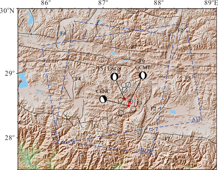
图 1 定日MW7.1地震构造背景
震源机制椭球分别来自GCMT,CENC,USGS;红色线条为POT测量解译的发震断层地表迹线;蓝色虚线方框代表InSAR升轨A12与降轨D121数据覆盖区域(数据见表 2);图中黑色圆圈表示自2015年尼泊尔地震之后至2025年定日地震发生之间,研究区内发生的5级以上的地震.断层编号及名称如下:F1. 藏南滑脱拆离系断裂;F2. 申扎‒定结断裂;F3. 登么错断裂;F4. 当惹雍错‒许如错断裂;F5. 札达‒拉孜‒邛多江断裂;F6. 达吉岭‒昂仁‒仁布断裂;F7. 雅鲁藏布江断裂.断层数据来自徐锡伟等(2016)
Fig. 1. Tectonic setting of the Dingri MW7.1 earthquake
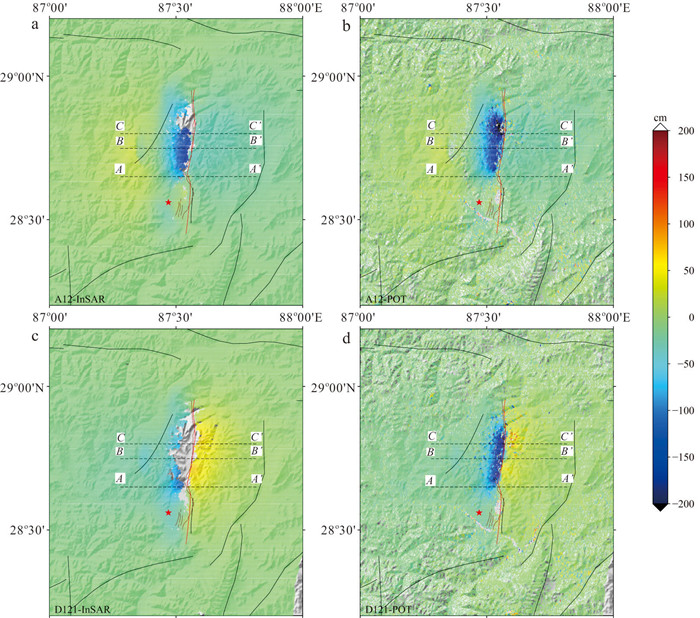
图 2 定日地震同震形变场
a~b分别是InSAR和POT测量获取的升轨形变场;c~d分别是InSAR和POT测量的降轨形变场;红线为同震变形场解译的发震断层;棕色线为石峰等(2025)野外测量的发震断层地表迹线;红色五角星表示GCMT震中位置
Fig. 2. Coseismic deformation field of the Dingri earthquake
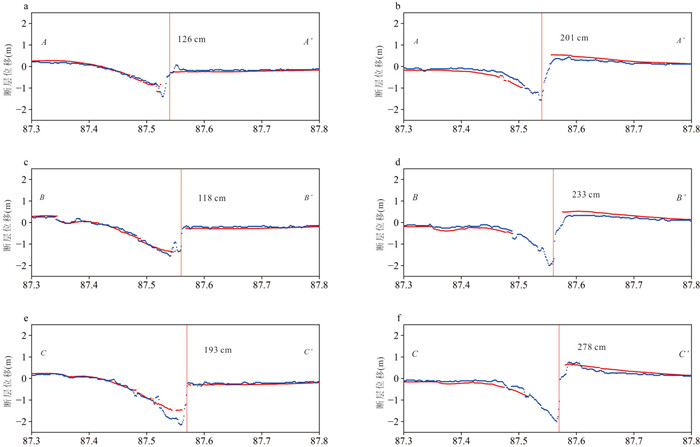
图 3 同震形变剖面
a,c,e分别为升轨形变场的AA'、BB'、CC'形变剖面;b,d,f分别为降轨形变场的AA'、BB'、CC'形变剖面;红线表示InSAR测量值,蓝线表示POT测量值;POT可以更好地测量断层近场变形信号;剖面线位置见图 2;红色垂线表示发震断层所在的位置
Fig. 3. Coseismic deformation profile
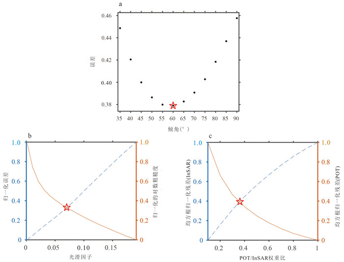
图 4 断层倾角、光滑因子与数据加权比搜索
a为断层倾角与反演残差之间的关系曲线;b为应力光滑因子与正规化反演残差、正规化对数粗糙度之间的折中曲线;c为POT/InSAR数据加权比与正规化反演残差之间的折中曲线;红色五角星代表参数最优解
Fig. 4. Search for fault dip angle, smoothing factor, and data weighting ratio
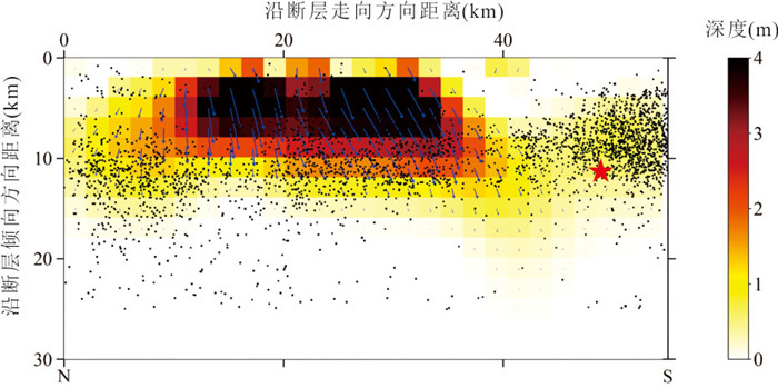
图 5 定日地震同震滑动分布
图中箭头表示断层滑动角;红色五角星表示精定位的主震震中;黑色圆点代表余震分布;余震精定位数据来自 杨婷等(2025)
Fig. 5. Coseismic slip distribution of the Dingri earthquake
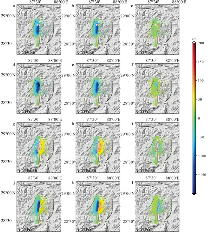
图 6 同震形变观测值、模拟值以及反演残差
a~c分别代表A12条带的InSAR观测值、模拟值与反演残差;d~f分别代表A12条带的POT观测值、模拟值与反演残差;g~i分别代表D121条带的InSAR观测值、模拟值与反演残差;j~l分别代表D121条带的POT观测值、模拟值与反演残差
Fig. 6. Coseismic deformation observations, simulated values, and inversion residuals
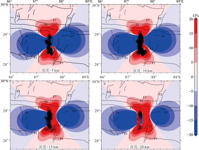
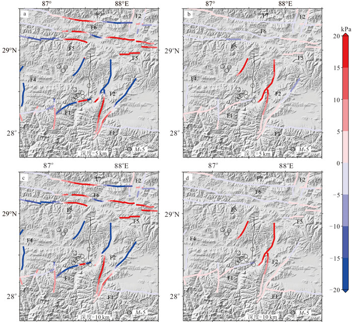
表 1 不同机构与学者给出的震源机制解
Table 1. Focal mechanism solutions provided by different institutions and scholars
来源 纬度(°N) 经度(°E) 深度(km) 走向(°) 倾向(°) 滑动角(°) 滑动深度(km) 最大滑动量(m) 最大滑动量深度(km) 地震矩(N·m) 震级 CENC 28.5 87.45 10 182 22 ‒64 - - - - MS6.8 334 71 ‒100 USGS 28.604 87.378 10 187 49 ‒78 - - - 4.749×10¹⁹ MW7.1 349 42 ‒103 GCMT 28.56 87.47 12 173 48 ‒92 - - - 5.29×10¹⁹ MW7.1 356 42 ‒88 杨建文等(2025) - - - 184 55 ‒64.75 0~15 4.25 8.6 - MW7.06 王楠等(2025) - - - 187 40 - 1~6 6 - - MW7.1 李雨森等(2025) - - - 189.33 52.8 ‒95.75 0~14 4.73 2~3 6.43×10¹⁹ MW7.17 Yu et al.(2025b) - - - 189.2 40.6 ‒82.81 0~10 4.6 - - MW7.1 Yu et al.(2025a) - - - 187 55 - 2~12 6.8 - 4.77×10¹⁹ MW7.1 本研究 - - - 185.03 60 ‒76.81 0~15 4.45 4.33 3.53×10¹⁹ MW7.0  下载: 导出CSV
表 2 Sentinel-1A数据
Table 2. Sentinel-1A data
Path 主影像日期 辅影像日期 模式 A12 2025‒01‒05 2025‒01‒17 升轨 D121 2025‒01‒01 2025‒01‒13 降轨
下载: 导出CSV
表 3 分层地壳模型
Table 3. Stratified crust model
分层(km) VP(km·s‒1) VS(km·s‒1) 密度(kg/m3) eta1(Pa·s) eta2(Pa·s) alpha 0~34.49 6.00 3.52 2 720 0 0 1.0 34.49~51.04 6.30 3.68 2 790 0.1×10¹⁹ 0.1×10²⁰ 0.5 51.04~68.98 6.60 3.82 2 850 0.1×10¹⁹ 0.1×10²⁰ 0.5 ≥68.98 8.36 4.63 3 420 0 0.1×10²¹ 1.0 注:中下地壳黏滞系数来自 Chen et al. (2024) ; 其他参数来自Crust1.0 (Laske et al., 2013 ).VP为P波传播速度,VS为S波传播速度,eta1为瞬态黏度,eta2为稳态黏度;alpha=μK/(μK+μM),其中μK与μM分别表示开尔文体黏滞系数和麦克斯韦体黏滞系数.
下载: 导出CSV
表 4 接收断层参数
Table 4. Receiver fault parameters
断层 走向(°) 倾角(°) 滑动角(°) 藏南滑脱拆离系断裂(F1) 45~180 45 ‒103 申扎‒定结断裂(F2) 203~210 45 ‒46 当惹雍错‒许如错断裂(F4) 0 69 ‒16 札达‒拉孜‒邛多江断裂(F5) 90 45 0 达吉岭‒昂仁‒仁布断裂(F6) 90 45 0 雅鲁藏布江断裂(F7) 90 45 ‒90 注:断层数据来自于 徐锡伟等(2016);登么错断裂(F3)在此次地震事件中发生破裂,短期内再次发生强震的风险较低,故不计算它的库仑应力扰动.
下载: 导出CSV
-
Ammon, C. J., Ji, C., Thio, H. K., et al., 2005. Rupture Process of the 2004 Sumatra-Andaman Earthquake. Science, 308(5725): 1133-1139. https://doi.org/10.1126/science.1112260 Bai, L., Chen, Z. W., Wang, S. J., 2025. The 2025 Dingri 6.8 Earthquake in Xizang: Analysis of Tectonic Background and Discussion of Source Characteristics. Reviews of Geophysics and Planetary Physics, 56(3): 258-263 (in Chinese). Chen, F., Diao, F. Q., Haghighi, M. H., et al., 2024. Mechanism and Implications of the Post-Seismic Deformation Following the 2021 MW7.4 Maduo (Tibet) Earthquake. Geophysical Journal International, 237(1): 203-216. https://doi.org/10.1093/gji/ggae034 Chlieh, M., Avouac, J. P., Hjorleifsdottir, V., et al., 2007. Coseismic Slip and Afterslip of the Great MW9.15 Sumatra-Andaman Earthquake of 2004. Bulletin of the Seismological Society of America, 97(1A): S152-S173. https://doi.org/10.1785/0120050631 Delouis, B., Nocquet, J. M., Vallée, M., 2010. Slip Distribution of the February 27, 2010 MW= 8.8 Maule Earthquake, Central Chile, from Static and High-Rate GPS, InSAR, and Broadband Teleseismic Data. Geophysical Research Letters, 37(17): L17305. https://doi.org/10.1029/2010GL043899 Farr, T. G., Rosen, P. A., Caro, E., et al., 2007. The Shuttle Radar Topography Mission. Reviews of Geophysics, 45(2): RG2004. https://doi.org/10.1029/2005RG000183 Hong, S. Y., Liu, M., Liu, T., et al., 2022. Fault Source Model and Stress Changes of the 2021 MW7.4 Maduo Earthquake, China, Constrained by InSAR and GPS Measurements. Bulletin of the Seismological Society of America, 112(3): 1284-1296. https://doi.org/10.1785/0120210250 Jiang, G. Y., Wen, Y. M., Liu, Y. J., et al., 2015. Joint Analysis of the 2014 Kangding, Southwest China, Earthquake Sequence with Seismicity Relocation and InSAR Inversion. Geophysical Research Letters, 42(9): 3273-3281. https://doi.org/10.1002/2015GL063750 Jónsson, S., Zebker, H., Segall, P., et al., 2002. Fault Slip Distribution of the 1999 MW7.1 Hector Mine, California, Earthquake, Estimated from Satellite Radar and GPS Measurements. Bulletin of the Seismological Society of America, 92(4): 1377-1389. https://doi.org/10.1785/0120000922 Laske, G., Masters, G., Ma, Z., et al., 2013. Update on CRUST1. 0-A 1-Degree Global Model of Earth's Crust. Geophysical Research Abstracts, 15(15): 2658. Lay, T., Kanamori, H., Ammon, C. J., et al., 2005. The Great Sumatra-Andaman Earthquake of 26 December 2004. Science, 308(5725): 1127-1133. https://doi.org/10.1126/science.1112250 Li, Y. S., Li, W. L., Xu, Q., et al., 2025. InSAR Coseismic Deformation Detection and Fault Slip Distribution Inversion of the MS6.8 Earthquake in Dingri, Tibet on January 7, 2025. Journal of Chengdu University of Technology (Science & Technology Edition), 52(2): 199-211 (in Chinese with English abstract). Miao, M., Zhu, S. B., 2012. A Study of the Impact of Static Coulomb Stress Changes of Megathrust Earthquakes along Subduction Zone on the Following Aftershocks. Chinese Journal of Geophysics, 55(9): 2982-2993 (in Chinese with English abstract). Ozawa, S., Nishimura, T., Suito, H., et al., 2011. Coseismic and Postseismic Slip of the 2011 Magnitude-9 Tohoku-Oki Earthquake. Nature, 475(7356): 373-376. https://doi.org/10.1038/nature10227 Pollitz, F. F., Brooks, B., Tong, X. P., et al., 2011. Coseismic Slip Distribution of the February 27, 2010 MW8.8 Maule, Chile Earthquake. Geophysical Research Letters, 38(9): L09309. https://doi.org/10.1029/2011GL047065 Rosen, P. A., Gurrola, E., Sacco, G. F., et al., 2012. The InSAR Scientific Computing Environment. EUSAR 2012, 9th European Conference on Synthetic Aperture Radar, Nuremberg, 730-733. Sheng, S. Z., Wang, Q. R., Li Z. Y., et al., 2025. Investigation of the Seismogenic Structure of the 2025 Dingri MS6.8 Earthquake in Xizang Base on the Tectonic Stress Filed Perspective. Seismology and Geology, 47(1): 49-63 (in Chinese with English abstract). doi: 10.3969/j.issn.0253-4967.2025.01.004 Shi, F., Liang, M. J., Luo, Q. X., et al., 2025. Seismogenic Fault and Coseismic Surface Deformation of the Dingri MS6.8 Earthquake in Xizang, China. Seismology and Geology, 47(1): 1-15 (in Chinese with English abstract). doi: 10.3969/j.issn.0253-4967.2025.01.001 Wang, N., Li, Y. S., Shen, W. H., et al., 2025. Source Parameters and Rapid Simulation of Strong Ground Motion of the MS6.8 Earthquake on January 7, 2025 in Dingri (Xizang, China) Derived from InSAR Observation. Geomatics and Information Science of Wuhan University, 50(2): 404-411 (in Chinese with English abstract). Wang, R., Diao, F., Hoechner, A., 2013. SDM-A Geodetic Inversion Code Incorporating with Layered Crust Structure and Curved Fault Geometry. EGU General Assembly Conference, Vienna, 2411. Wang, R. J., Lorenzo-Martín, F., Roth, F., 2006. PSGRN/PSCMP—A New Code for Calculating Co- and Post-Seismic Deformation, Geoid and Gravity Changes Based on the Viscoelastic-Gravitational Dislocation Theory. Computers & Geosciences, 32(4): 527-541. https://doi.org/10.1016/j.cageo.2005.08.006 Wang, Y. Z., 2015. Coseismic Slip Distribution of the 2011 Tohoku MW9.0 Earthquake Inferred from GPS and InSAR Data. Acta Seismologica Sinica, 37(5): 796-805 (in Chinese with English abstract). Wei, B. Y., Zhang, Y. M., Shi, F., et al., 2025. Analysis of Building Damage and Casualties of the 2025 Dingri MS6.8 Earthquake in Xizang Based on Field Investigation. Seismology and Geology, 47(1): 64-79 (in Chinese with English abstract). Xu, C. J., He, P., W, Y. M., et al., 2012. Coseismic Deformation Slip Distribution for 2011 Tohoku-Oki MW9.0 Earthquake: Constrained by GPS and InSAR. Geomatics and Information Science of Wuhan University, 37(12): 1387-1391 (in Chinese with English abstract). Xu, X. W., Han, Z. J., Yang, X. P., et al., 2016. Seismotectonic Map in China and Its Adjacent Regions. Seismological Press, Beijing (in Chinese). Xu, X. W., Wang, S. G., Cheng, J., et al., 2025. Shaking the Tibetan Plateau: Insights from the MW7.1 Dingri Earthquake and Its Implications for Active Fault Mapping and Disaster Mitigation. NPJ Natural Hazards, 2: 16. https://doi.org/10.1038/s44304-025-00074-7 Yang, J. W., Jin, M. P., Ye, B., et al., 2025. Source Rupture Mechanism and Stress Changes to the Adjacent Area of January 7, 2025, MS6.8 Dingri Earthquake, Xizang, China. Seismology and Geology, 47(1): 36-48. (in Chinese with English abstract). Yang, T., Wang, S. G., Fang, L. H., et al., 2025. Analysis of Earthquake Sequence and Seismogenic Structure of the 2025 MS6.8 Dingri Earthquake in Tibetan Plateau. Earth Science, 50(5): 1721-1732 (in Chinese with English abstract). https://doi.org/10.3799/dqkx.2025.033 Yu, C., Li, Z. H., Hu, X. N., et al., 2025a. Source Characteristics and Induced Hazards of the 2025 MW6.8 Dingri Earthquake, Xizang, China, Revealed by Imaging Geodesy. Journal of Earth Science, 36(2): 847-851. https://doi.org/10.1007/s12583-025-0175-8 Yu, S. Y., Zhang, S. B., Luo, J. J., et al., 2025b. The Tectonic Significance of the MW7.1 Earthquake Source Model in Tibet in 2025 Constrained by InSAR Data. Remote Sensing, 17(5): 936. https://doi.org/10.3390/rs17050936 Zhang, J. J., Guo, L., Ding, L., 2002. Structural Characteristics of the Middle and Southern Segment of the Shenzha-Dingjie Normal Fault System and Its Relationship with the Detachment System in Southern Tibet. Chinese Science Bulletin, 47(10): 738-743 (in Chinese). Zhang, X. T., Jiang, X. H., Xue, Y., et al., 2020. Summary of the Dingri MS5.9 Earthquake in Tibet on March 20, 2020. Seismological and Geomagnetic Observation and Research, 41(4): 193-203 (in Chinese with English abstract). Zhang, Y., Xu, L. S., Chen, Y. T., 2012. Rupture Process of the 2011 Tohoku Earthquake from the Joint Inversion of Teleseismic and GPS Data. Earthquake Science, 25(2): 129-135. https://doi.org/10.1007/s11589-012-0839-1 白玲, 陈治文, 王绍俊, 2025. 2025年西藏定日6.8级地震: 构造背景分析与震源特征探讨. 地球与行星物理论评(中英文), 56(3): 258-263. 李雨森, 李为乐, 许强, 等, 2025. 2025年1月7日西藏定日MS6.8级地震InSAR同震形变探测与断层滑动分布反演. 成都理工大学学报(自然科学版), 52(2): 199-211. 缪淼, 朱守彪, 2012. 俯冲带上特大地震静态库仑应力变化对后续余震触发效果的研究. 地球物理学报, 55(9): 2982-2993. 盛书中, 王倩茹, 李振月, 等, 2025. 基于构造应力场研究2025年西藏定日6.8级地震的发震构造. 地震地质, 47(1): 49-63. 石峰, 梁明剑, 罗全星, 等, 2025. 2025年1月7日西藏定日6.8级地震发震构造与同震地表破裂特征. 地震地质, 47(1): 1-15. 王楠, 李永生, 申文豪, 等, 2025. 2025年1月7日西藏定日MS6.8地震震源机制InSAR反演及强地面运动快速模拟. 武汉大学学报(信息科学版), 50(2): 404-411. 王永哲, 2015. 利用GPS和InSAR数据反演2011年日本东北MW9.0地震断层的同震滑动分布. 地震学报, 37(5): 796-805, 885. 魏本勇, 张钰曼, 石峰, 等, 2025. 基于现场调查的2025西藏定日MS6.8地震房屋震害与人员伤亡分析. 地震地质, 47(1): 64-79. 许才军, 何平, 温扬茂, 等, 2012. 日本2011 Tohoku-Oki MW9.0级地震的同震形变及其滑动分布反演: GPS和InSAR约束. 武汉大学学报(信息科学版), 37(12): 1387-1391. 徐锡伟, 韩竹军, 杨晓平, 等, 2016. 中国及邻区地震构造图. 北京: 地震出版社. 杨建文, 金明培, 叶泵, 等, 2025. 2025年1月7日西藏定日6.8级地震震源破裂机理及邻区应力变化. 地震地质, 47(1): 36-48. 杨婷, 王世广, 房立华, 等, 2025. 2025年1月7日西藏定日MS6.8地震余震序列特征与发震构造, 地球科学, 50(5): 1721-1732. doi: 10.3799/dqkx.2025.033 张进江, 郭磊, 丁林, 2002. 申扎‒定结正断层体系中、南段构造特征及其与藏南拆离系的关系. 科学通报, 47(10): 738-743. 张小涛, 姜祥华, 薛艳, 等, 2020. 2020年3月20日西藏定日MS5.9地震总结. 地震地磁观测与研究, 41(4): 193-203. -

 点击查看大图
计量
- 文章访问数: 107
- HTML全文浏览量: 6
- PDF下载量: 27
- 被引次数: 0
