


Remote Sensing Dataset Construction and Intelligent Identification Algorithm Evaluation for Talus Slopes in High-Altitude Cold Regions
-
摘要:
高寒山区溜砂坡分布广泛、形态复杂且灾害风险高,但受制于恶劣环境与数据匮乏,其智能识别面临重大挑战.通过构建首个高分辨率溜砂坡语义分割数据集,实现数据资源建设的突破.基于高分二号高分辨率遥感影像,建立包含形态-光谱-环境多维度解译标志体系,形成3 811组标准化标注样本的开放数据集.基于统一的数据集和评价体系,评估4类卷积神经网络与2类Transformer模型的分割性能,验证了基于Transformer架构和动态Mask注意力的Mask2Former模型在复杂地貌下的技术优势(平均交并比75.72%,F1分数77.62%).具备优异的泛化能力与鲁棒性,实现溜砂坡的精准识别.这项研究不仅填补了高寒山区溜沙坡数据资源的空白,并且为复杂地貌场景下智能识别模型的选型提供了科学依据.
Abstract:Talus slopes in high-altitude cold mountain regions, characterized by extensive distribution, complex morphology, and elevated geohazard risks, pose significant challenges for intelligent identification due to harsh environmental conditions and data scarcity. This study addresses this gap by constructing the first high-resolution semantic segmentation dataset for talus slope detection. Utilizing Gaofen-2 (GF-2) satellite imagery, it developed a multidimensional interpretation framework incorporating morphological, spectral, and environmental criteria, culminating in an open-access benchmark dataset comprising 3 811 standardized annotated samples. Through systematic evaluation of four convolutional neural network architectures and two Transformer-based models under unified experimental protocols, it validated the technical superiority of the Mask2Former model-integrating Transformer architecture with dynamic Mask attention mechanisms - in complex terrain scenarios, achieving a mean Intersection over Union (mIoU) of 75.72% and F1-score of 77.62%. The proposed methodology has demonstrated exceptional generalization capability and robustness in precise talus slope delineation. This research not only addresses the critical data gap for talus slope studies in alpine environments but also provides scientific guidelines for model selection in intelligent recognition tasks across complex geomorphological settings. The established dataset and multidimensional interpretation system offer valuable references for advancing geohazard monitoring through intelligent remote sensing technologies in cold mountainous regions.
-
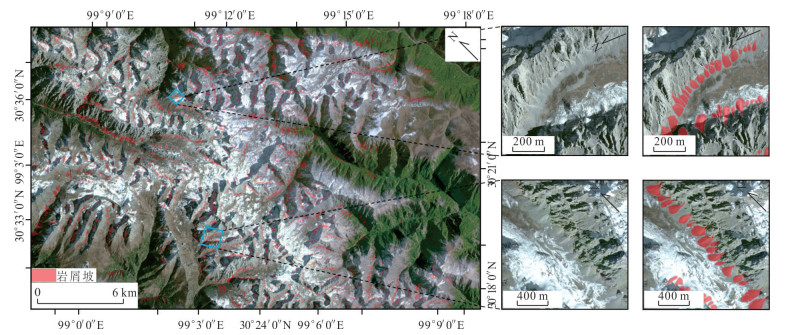
图 2 研究区高分2号高清遥感影像
Fig. 2. GF-2 high-resolution remote sensing imagery of the study area
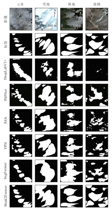
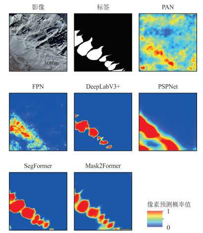
图 5 模型对验证集不同场景下语义分割可视化识别结果
Fig. 5. Visual recognition results of semantic segmentation of the models in different scenarios of the training set
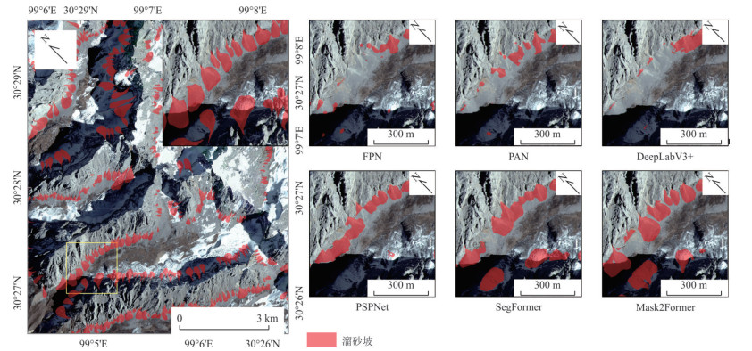
图 6 模型对独立测试集语义分割表现可视化识别结果
Fig. 6. Visualization of semantic segmentation performance and recognition results of the models on the test set
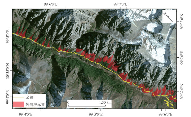
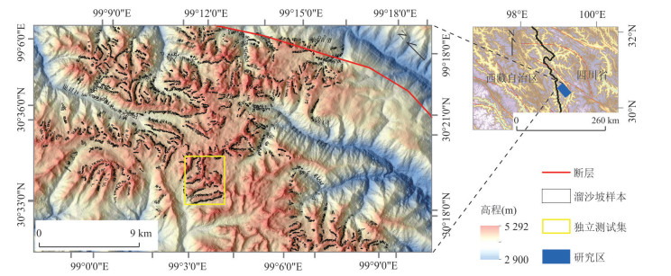
图 8 研究区公路沿线溜砂坡空间分布
Fig. 8. Spatial distribution of highway-adjacent talus slopes in the study area
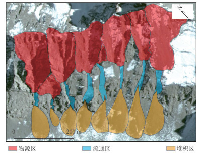
表 1 形态-光谱-环境多维度的溜砂破遥感标志体系
Table 1. Remote sensing indicator system of talus slopes based on morphological-spectral-environmental multi-dimensional features
形态 光谱 环境 物源区 坡度较陡,与崩塌、滑坡等非风化作用引起的灾害不同,溜砂坡的后壁多为基岩,且无明显裂缝* 浅灰或亮白色调,由于基岩裸露且风化砂粒松散,亮度值较高,在低太阳高度角影像中,陡峭的岩壁或崩落面可能形成明显阴影* 多为裸露基岩,缺乏植被覆盖* 流通区 具有较强的磨蚀性,通常宽浅、边缘平缓,沟系流线光滑(韦方强等, 2002) 整体细长,呈现线性或沟槽状粗糙纹理,在影像中表现为纵向暗色条纹* 多为粗砂和碎碎岩屑,缺乏植被覆盖* 堆积区 呈锥状或扇形地貌堆积物粒径较为均一,坡度上呈然堆积角(刘桂卫等, 2019) 色调均匀且明亮,表面均一性较好,纹理平滑* 质地较为疏松,持水条件较好,植被生长不完全或不连续,但在强烈活动的岩屑堆积区域,植被几乎无法生长* 注:“*”表示本研究新增或拓展的解译标志.  下载: 导出CSV
表 2 语义分割模型技术对比
Table 2. Technical comparison of semantic segmentation models
模型 特征融合方式 上下文建模范围 计算复杂度(GFLOPs) 参数量(M) DeepLabV3+ ASPP空间金字塔 局部-全局 45.6 54.7 PSPNet 金字塔池化 局部-全局 37.2 48.6 PAN 双向特征金字塔 局部多尺度 49.5 36.2 FPN 横向连接特征金字塔 局部多尺度 26.4 23.5 SegFormer 混合窗口注意力+MLP融合 全局 62.4 64.1 Mask2Former 多尺度Transformer解码器+动态Mask注意力 全局 58.2 44.5
下载: 导出CSV
表 3 模型对验证集语义分割表现评价指标对比
Table 3. Comparison of the performance evaluation indicators of the models in semantic segmentation on the training set
模型名称 mIoU (%) F1分数(%) 精确率(%) 召回率(%) DeepLabV3+ 54.04±0.93 29.43±0.87 43.62±1.16 22.46±1.05 PSPNet 60.25±0.97 44.00±0.76 65.15±1.18 32.91±1.10 PAN 68.31±1.12 59.71±1.17 83.82±0.94 46.41±1.42 FPN 71.53±1.16 64.93±1.04 80.86±0.96 54.77±0.82 SegFormer 77.89±1.04 74.85±1.00 79.64±1.31 70.84±1.33 Mask2Former 80.95±0.92 85.61±0.90 84.63±0.96 87.68±1.08
下载: 导出CSV
表 4 模型对测试集语义分割表现评价指标对比
Table 4. Comparison of semantic segmentation performance evaluation metrics for models on the test set
模型名称 mIoU (%) F1分数(%) 精确率(%) 召回率(%) FPN 60.28±0.43 38.14±0.37 51.89±0.53 30.09±0.43 PAN 60.62±0.59 39.28±0.43 62.96±0.59 28.41±0.44 DeepLabV3+ 63.67±0.54 47.18±0.50 45.54±0.58 48.97±0.69 PSPNet 64.29±0.70 47.82±0.63 62.36±0.75 38.64±0.66 SegFormer 70.48±0.63 60.35±0.63 62.91±0.82 58.12±0.72 Mask2Former 75.72±0.54 77.62±0.75 76.63±0.85 79.49±0.60
下载: 导出CSV
-
Chen, L. C., Papandreou, G., Kokkinos, I., et al., 2018. DeepLab: Semantic Image Segmentation with Deep Convolutional Nets, Atrous Convolution, and Fully Connected CRFS. IEEE Transactions on Pattern Analysis and Machine Intelligence, 40(4): 834-848. https://doi.org/10.1109/TPAMI.2017.2699184 Chen, R. S., Kang, E. S., Wu, L. Z., et al., 2005. Cold Regions in China. Journal of Glaciology and Geocryology, 27(4): 469-475 (in Chinese with English abstract). Cheng, G. D., He, P., 2001. Linearity Engineering in Permafrost Areas. Journal of Glaciolgy and Geocryology, 23(3): 213-217 (in Chinese with English abstract). Cui, H. T., Chang, Z. Y., Zhang, Z. G., et al., 2021. The Characteristics of Sunshine Duration in Garzê Tibetan Autonomous Prefecture of Western Sichuan in China during 1961—2015. Journal of Earth Environment, 12(6): 641-653 (in Chinese with English abstract). Fang, C. Y., Fan, X. M., Wang, X., et al., 2024. A Globally Distributed Dataset of Coseismic Landslide Mapping via Multi-Source High-Resolution Remote Sensing Images. Earth System Science Data, 16: 4817-4842. https://doi.org/10.5194/essd-16-4817-2024 Fang, H., Lafarge, F., 2019. Pyramid Scene Parsing Network in 3D: Improving Semantic Segmentation of Point Clouds with Multi-Scale Contextual Information. ISPRS Journal of Photogrammetry and Remote Sensing, 154: 246-258. https://doi.org/10.1016/j.isprsjprs.2019.06.010 Farmakis, I., DiFrancesco, P. M., Hutchinson, D. J., et al., 2022. Rockfall Detection Using LiDAR and Deep Learning. Engineering Geology, 309: 106836. https://doi.org/10.1016/j.enggeo.2022.106836 Feng, P. F., Li, C. D., Zhang, S., et al., 2024. Integrating Shipborne Images with Multichannel Deep Learning for Landslide Detection. Journal of Earth Science, 35(1): 296-300. https://doi.org/10.1007/s12583-023-1957-5 Gao, M., Chen, F., Wang, L., et al., 2024. Swin Transformer-Based Multi-Scale Attention Model for Landslide Extraction from Large-Scale Area. IEEE Transactions on Geoscience and Remote Sensing(in Press). doi: https://doi.org/10.1109/TGRS.2024.3477910 Huang, C. F., 2019. Study on the Development Law and Stability of Clastic Slope in Southeast Tibet of G318 National Highway (Dissertation). Southwest Jiaotong University, Chengdu (in Chinese with English abstract). Ju, Y. Z., Xu, Q., Jin, S. C., et al., 2020. Automatic Object Detection of Loess Landslide Based on Deep Learning. Geomatics and Information Science of Wuhan University, 45(11): 1747-1755 (in Chinese with English abstract). Li, C. Y., Cui, P., Hao, J. S., et al., 2023. Variation Characteristics of Temperature and Precipitation over the Southeast Xizang since 1960. Plateau Meteorology, 42(2): 344-358 (in Chinese with English abstract). Liu, G. W., Li, G. H., Chen, Z. L., et al., 2019. Application of Remote Sensing Technology for Geological Investigation in Mountain Railways. Journal of Railway Engineering Society, 36(8): 4-8 (in Chinese with English abstract). Ma, S. H., Wu, J., Zhang, Z. J., et al., 2024. Application of Enhanced YOLOX for Debris Flow Detection in Remote Sensing Images. Applied Sciences, 14(5): 2158. https://doi.org/10.3390/app14052158 Mei, J., Wang, J., He, L., et al., 2019. Spatio-Temporal Variations of Temperature and Precipitation in Ganzi of Western Sichuan in China during 1961—2015. Mountain Research, 37(2): 161-172 (in Chinese with English abstract). Rai, S. N., Cermelli, F., Caputo, B., et al., 2025. Mask2Anomaly: Mask Transformer for Universal Open-Set Segmentation. IEEE Transactions on Pattern Analysis and Machine Intelligence, 46: 9286-9302. https://doi.org/10.1109/TPAMI.2024.3419055 Tang, X. C., Tu, Z. H., Wang, Y., et al., 2022. Automatic Detection of Coseismic Landslides Using a New Transformer Method. Remote Sensing, 14(12): 2884. https://doi.org/10.3390/rs14122884 Wang, R. K., Ma, L., He, G. J., et al., 2024. Transformers for Remote Sensing: A Systematic Review and Analysis. Sensors, 24(11): 3495. https://doi.org/10.3390/s24113495 Wang, Z. Y., 2023. A Study on the Spatial Development Law of Rock Debris Slopes along G219 in the Himalayan Mountains—Taking Lhasa to Kashgar as an Example (Dissertation). Wuhan Institute of Technology, Wuhan (in Chinese with English abstract). Wei, F. Q., He, Y. P., Hu, K. H., et al., 2002. Remote Sensing Interpretation of Sliding Sand Slope in the Section of Ranwu-Zhongba in Sichuan-Tibet Highway. Journal of Natural Disasters, 11(4): 124-128 (in Chinese with English abstract). Xiang, X. Y., Gong, W. P., Li, S. L., et al., 2024. TCNet: Multiscale Fusion of Transformer and CNN for Semantic Segmentation of Remote Sensing Images. IEEE Journal of Selected Topics in Applied Earth Observations and Remote Sensing, 17: 3123-3136. https://doi.org/10.1109/JSTARS.2024.3349625 Xie, E. Z., Wang, W. H., Yu, Z. D., et al., 2021. SegFormer: Simple and Efficient Design for Semantic Segmentation with Transformers. Advances in Neural Information Processing Systems, 34: 12077-12090. https://doi.org/10.48550/arXiv.2105.15203 Xu, L. J., Hu, Z. Y., Zhao, Y. N., et al., 2019. Climate Change Characteristics in Qinghai-Tibetan Plateau during 1961—2010. Plateau Meteorology, 38(5): 911-919 (in Chinese with English abstract). Xu, Q., Dong, X. J., Li, W. L., 2019. Integrated Space-Air-Ground Early Detection, Monitoring and Warning System for Potential Catastrophic Geohazards. Geomatics and Information Science of Wuhan University, 44(7): 957-966 (in Chinese with English abstract). Xu, Q., Lu, H. Y., Li, W. L., et al., 2022. Types of Potential Landslide and Corresponding Identification Technologies. Geomatics and Information Science of Wuhan University, 47(3): 377-387 (in Chinese with English abstract). Yang, D. H., 2019. Analysis of Main Engineering Geological Problems in Changdu to Linzhi Section of Sichuan-Tibet Railway. Railway Standard Design, 63(9): 16-22, 27 (in Chinese with English abstract). Yu, H. F., Li, X. B., Feng, Y. K., et al., 2023. Multiple Attentional Path Aggregation Network for Marine Object Detection. Applied Intelligence, 53(2): 2434-2451. https://doi.org/10.1007/s10489-022-03622-0 Zhang, C. C., Ding, M. T., Shen, C. Q., et al., 2025. Intelligent Recognition of Coseismic Landslides Based on MultiU-EGANet Model. Earth Science, 50(8): 3182-3198 (in Chinese with English abstract). Zhang, G. Z., Jiang, L. W., Song, Z., et al., 2016. Research on the Mountain Disaster and Geological Alignment Fundamental of Sichuan-Tibet Railway Running through N-S Mountain Area. Journal of Railway Engineering Society, 33(2): 21-24, 33 (in Chinese with English abstract). Zhang, Q., Zhao, C. Y., Chen, X. R., 2022. Technical Progress and Development Trend of Geological Hazards Early Identification with Multi-Source Remote Sensing. Acta Geodaetica et Cartographica Sinica, 51(6): 885-896 (in Chinese with English abstract). Zhang, S. S., Li, Q. C., Li, H., et al., 2025. Intelligent Identification of Ice Lakes in Complex Plateau Terrain Based on Multi-Source Remote Sensing Data and Improved Mask R-CNN Deep Learning Model. Earth Science: 1-23. (2025-03-06). https://kns.cnki.net/kcms/detail/42.1874.P.20250305.1439.004.html Zhong, D. J., Yang, C. J., 2022. Spatiotemporal Variation Characteristics of Vegetation EVI and Driving Forces of Climate Factors in Western Sichuan Plateau from 2001 to 2020. Research of Soil and Water Conservation, 29(4): 223-230 (in Chinese with English abstract). Zhou, B., Zou, Q., Jiang, H., et al., 2022. Research on Climate Change Characteristics and Change of Debris Flow Hazard in the Chuanxi Plateau. Journal of Natural Disasters, 31(4): 241-255 (in Chinese with English abstract). Zhu, L. X., Lee, F. F., Cai, J. W., et al., 2022. An Improved Feature Pyramid Network for Object Detection. Neurocomputing, 483: 127-139. https://doi.org/10.1016/j.neucom.2022.02.016 陈仁升, 康尔泗, 吴立宗, 等, 2005. 中国寒区分布探讨. 冰川冻土, 27(4): 469-475. 程国栋, 何平, 2001. 多年冻土地区线性工程建设. 冰川冻土, 23(3): 213-217. 崔海涛, 常直杨, 张志刚, 等, 2021. 川西甘孜藏族自治州1961—2015年日照时数变化特征分析. 地球环境学报, 12(6): 641-653. 窦杰, 唐辉明, 董傲男, 等, 2025. 融合多尺度特征与注意力机制的地震地表裂缝智能识别与特征分析: 以2025年西藏定日Ms6.8地震为例. 地球科学, 50(5): 1744-1758. 黄楚枫, 2019. G318国道藏东南段碎屑坡发育规律及稳定性研究(硕士学位论文). 成都: 西南交通大学. 巨袁臻, 许强, 金时超, 等, 2020. 使用深度学习方法实现黄土滑坡自动识别. 武汉大学学报(信息科学版), 45(11): 1747-1755. 李朝月, 崔鹏, 郝建盛, 等, 2023.1960年以来藏东南地区气温和降水的变化特征. 高原气象, 42(2): 344-358. 刘桂卫, 李国和, 陈则连, 等, 2019. 多源遥感技术在艰险山区铁路地质勘察中应用. 铁道工程学报, 36(8): 4-8. 梅静, 王建, 何亮, 等, 2019. 川西甘孜州1961—2015年气温和降水时空变化特征研究. 山地学报, 37(2): 161-172. 王卓羽, 2023. 喜马拉雅山区G219沿线岩屑坡空间发育规律研究: 以拉萨到喀什为例(硕士学位论文). 武汉: 武汉工程大学. 韦方强, 何易平, 胡凯衡, 等, 2002. 溜砂坡遥感解译标志与方法: 以川藏公路然乌—中坝段为例. 自然灾害学报, 11(4): 124-128. 徐丽娇, 胡泽勇, 赵亚楠, 等, 2019.1961—2010年青藏高原气候变化特征分析. 高原气象, 38(5): 911-919. 许强, 董秀军, 李为乐, 2019. 基于天-空-地一体化的重大地质灾害隐患早期识别与监测预警. 武汉大学学报(信息科学版), 44(7): 957-966. 许强, 陆会燕, 李为乐, 等, 2022. 滑坡隐患类型与对应识别方法. 武汉大学学报(信息科学版), 47(3): 377-387. 杨德宏, 2019. 川藏铁路昌都至林芝段主要工程地质问题分析. 铁道标准设计, 63(9): 16-22, 27. 张灿灿, 丁明涛, 申传庆, 等, 2025. 基于MultiU-EGANet模型的同震滑坡智能识别. 地球科学, 50(8): 3182-3198. doi: 10.3799/dqkx.2025.067 张广泽, 蒋良文, 宋章, 等, 2016. 横断山区川藏线山地灾害和地质选线原则研究. 铁道工程学报, 33(2): 21-24, 33. 张勤, 赵超英, 陈雪蓉, 2022. 多源遥感地质灾害早期识别技术进展与发展趋势. 测绘学报, 51(6): 885-896. 张世殊, 李青春, 黎昊, 等, 2025. 融合多源遥感数据和改进的Mask R-CNN深度学习模型的复杂高原地形区冰湖智能识别. 地球科学: 1-23. (2025-03-06). https://kns.cnki.net/kcms/detail/42.1874.P.20250305.1439.004.html .钟鼎杰, 杨存建, 2022.2001—2020年川西高原植被EVI时空变化特征及气候因子驱动力分析. 水土保持研究, 29(4): 223-230. 周斌, 邹强, 蒋虎, 等, 2022. 川西高原气候变化特征及泥石流动态危险性响应研究. 自然灾害学报, 31(4): 241-255. -

 点击查看大图
计量
- 文章访问数: 253
- HTML全文浏览量: 18
- PDF下载量: 44
- 被引次数: 0
