


Identification of Potential Unstable Blocks on High and Steep Rock Slope and Quantitative Analysis of Hazard Effects
-
摘要:
为解决山区重大工程建设中面临的高陡岩质斜坡潜在不稳定块体空间定位难、灾害效应量化分析不足的瓶颈问题.提出了一种融合无人机摄影测量、结构面解译算法、三维运动学分析及落石运动模拟的高位潜在不稳定块体识别定位、失稳模式判识及其灾害效应分析的综合分析框架.以大渡河双江口水电站坝址左岸一高位岩体露头为例,该框架有效识别出92处潜在不稳定块体,确定其潜在失稳模式以楔形体破坏为主.落石三维运动轨迹模拟结果表明不稳定块体失稳后整体呈现加速-减速的循环趋势,最远运动距离为845.6 m,对水电站枢纽区影响较小.强调了不稳定块体空间精准定位对落石灾害风险预测精度提升的重要性,这对落石灾害防控具有重要指导意义.
Abstract:To address the bottlenecks encountered in major engineering works in mountainous regions namely, the difficulty of spatially locating potentially unstable blocks on high and steep rock slope and the insufficiency of quantitative analyses of associated hazard effects, this study proposes an integrated analytical framework combining unmanned aerial vehicle (UAV) photogrammetry, discontinuity interpretation algorithms, three dimensional (3D) kinematic analysis, and rockfall numerical simulation to identify and locate high-elevation potentially unstable blocks, determine their failure modes, and analyze associated hazard effects. Taking the high-elevation rock outcrop on the left bank of the Shuangjiangkou hydropower station dam site on the Dadu River as an example, the framework effectively identified 92 potentially unstable blocks and determined that wedge failure is the primary instability mode. The simulated 3D rockfall trajectories show that, after destabilization, the blocks exhibit cyclic acceleration-deceleration trends, with a maximum runout distance of 845.6 m, posing minimal impact on the hydropower hub area. In addition, this study emphasizes the importance of precise spatial localization of unstable blocks for improving rockfall hazard risk prediction accuracy, which has important implications for rockfall disaster prevention and control.
-
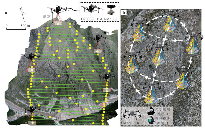
图 2 无人机飞行策略
a.区域仿地正射测量;b.重点露头多角度贴近摄影测量
Fig. 2. Unmanned aerial vehicle (UAV) flight strategy
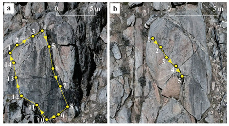
图 3 人工平面分割法示意图
a.面状结构面提取;b.线状结构面提取
Fig. 3. Schematic of manual planar segmentation method
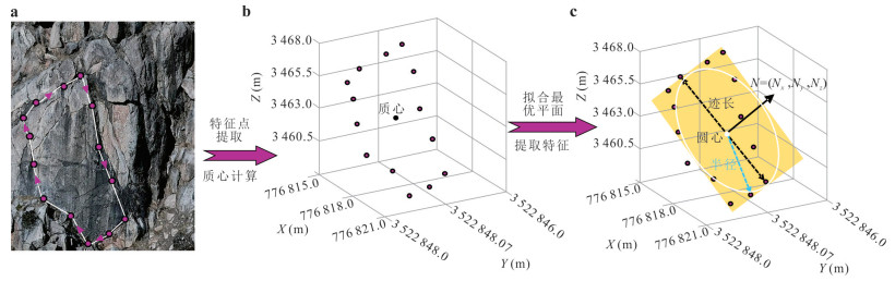
图 4 结构面平面拟合
a.特征点位置;b.提取特征点计算质心;c.拟合平面及Baecher圆盘
Fig. 4. Plane fitting of discontinuity
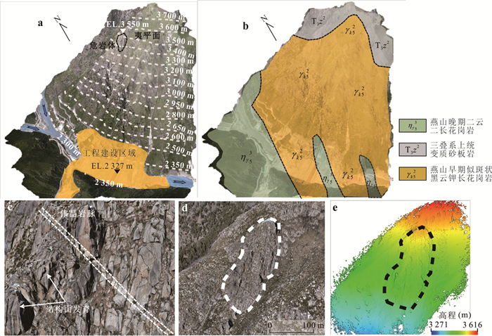
图 5 研究区概况
a.边坡模型;b.边坡岩性图;c.重点露头岩性及典型结构面;d.重点露头光学模型;e重点露头点云模型
Fig. 5. Overview of the study area
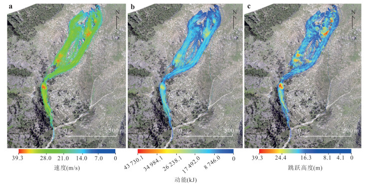
图 10 落石轨迹数值模拟结果
a.速度;b.动能;c.跳跃高度
Fig. 10. Numerical simulation results of rockfall trajectories
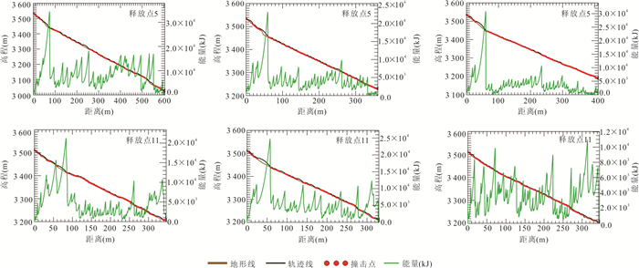
图 11 释放点5和11的块体运动轨迹剖面及块体动力学参数变化曲线
Fig. 11. Profiles of block trajectories and dynamic parameter variation for release points 5 and 11
表 1 RAMMS: Rockfall中地形类别及摩擦参数预设值
Table 1. Specification of terrain types and preset friction parameters in RAMMS: Rockfall
地类 范例 $ {\mu }_{\mathrm{m}\mathrm{i}\mathrm{n}} $ $ {\mu }_{\mathrm{m}\mathrm{a}\mathrm{x}} $ $ {\beta }_{s} $ k Cv 极软 沼泽、草地 0.20 2.00 50 1.00 0.9 软 湿草甸 0.25 2.00 100 1.25 0.8 中软 草甸(厚腐殖层) 0.30 2.00 125 1.50 0.7 中 草甸(中厚腐殖层) 0.35 2.00 150 2.00 0.6 中硬 山地草甸、未铺面山路、卵砾石 0.40 2.00 175 2.50 0.5 硬 岩屑堆、卵砾石、铺面公路 0.55 2.00 185 3.00 0.4 极硬 基岩、陡崖 0.80 2.00 200 4.00 0.3 雪地 雪地 0.10 0.35 150 2.00 0.7  下载: 导出CSV
-
An, Z. L., Wang, F. Y., Wang, M. C., et al., 2025. Rapid Flight Path Planning and Application of High and Steep Slopes Based on UAV Multi-Pose Nap-of-the-Object Photogrammetry. Journal of Jilin University (Earth Science Edition), 55(1): 209-222 (in Chinese with English abstract). Chen, C. F., He, K. Y., Yu, J. Y., et al., 2022. Identification of Discontinuities of High Steep Slope Based on UAV Nap-of-the-Object Photography. Journal of Hunan University (Natural Sciences), 49(1): 145-154 (in Chinese with English abstract). Chen, L., Zeng, W. Q., Wang, X. B., et al., 2024. A Three-Dimensional DEM Method for Trajectory Simulations of Rockfall under Irregular-Shaped Slope Surface and Rock Blocks. Journal of Earth Science, 35(1): 306-312. https://doi.org/10.1007/s12583-023-1959-3 Du, W. J., Sheng, Q., Fu, X. D., et al., 2025. Application of Unmanned Aerial Vehicle Remote Sensing on Dangerous Rock Mass Identification and Deformation Analysis: Case Study of a High-Steep Slope in an Open Pit Mine. Journal of Earth Science, 36(2): 750-763. https://doi.org/10.1007/s12583-023-1813-7 Gao, B. L., Zhang, J. H., Zhang, L. Q., 2022. Deterioration Characteristics of Structural Plane and Dynamic Instability Mechanism of High Dangerous Rock Mass under Earthquake. Earth Science, 47(12): 4417-4427 (in Chinese with English abstract). Jia, S. G., Jin, A. B., Zhao, Y. Q., 2018. Application of UAV Oblique Photogrammetry in the Field of Geology Survey at the High and Steep Slope. Rock and Soil Mechanics, 39(3): 1130-1136 (in Chinese with English abstract). Jiang, T., Wei, Y. F., Cui, S. H., et al., 2025.3D Rockfall Trajectories Analysis Considering Earthquake-Induced Initial Velocities: A Case Study in Nujiang Bridge Area, China. Landslides, 22(6): 2055-2072. https://doi.org/10.1007/s10346-025-02468-0 Li, S. Q., Zhang, H. C., Liu, R. Y., 2017. Semi-Automatically Counting Orientations of Rock Mass Structural Plane Based on Unmanned Aerial Vehicle Photogrammetry. Science Technology and Engineering, 17(26): 18-22 (in Chinese with English abstract). Li, Y., He, K., Hu, X. W., et al., 2022. Formation Characteristics and Kinematics 3-D Simulation of Rockfall Evolved from Shattered Mountain—Case Study of Sanguanmiao Village Rockfall in Wenchuan County. Journal of Engineering Geology, 30(2): 542-552 (in Chinese with English abstract). Liu, Y. Q., Chen, J. P., Tan, C., et al., 2022. Intelligent Scanning for Optimal Rock Discontinuity Sets Considering Multiple Parameters Based on Manifold Learning Combined with UAV Photogrammetry. Engineering Geology, 309: 106851. https://doi.org/10.1016/j.enggeo.2022.106851 Menegoni, N., Giordan, D., Perotti, C., et al., 2021. An Open-Source Algorithm for 3D Rock Slope Kinematic Analysis (ROKA). Applied Sciences, 11(4): 1698. https://doi.org/10.3390/app11041698 Mineo, G., Rosone, M., Cappadonia, C., 2025. Semi-Automated Rock Block Volume Extraction from High-Resolution 3D Point Clouds for Enhanced Rockfall Hazard Analysis. International Journal of Rock Mechanics and Mining Sciences, 185: 105982. https://doi.org/10.1016/j.ijrmms.2024.105982 Palmström A, 2001. In-Situ Characterization of Rocks. Balkema, Rotterdam, 49-97. Pan, X. J., Zhang, W., Sun, Q., 2024. Complex Structural Plane Distribution of High-Steep Rockslope and Division of Statistical Homogeneous Zones. Earth Science, 49(9): 3334-3346 (in Chinese with English abstract). Pu, C. L., Zhan, J. W., Huang, D., et al., 2025. Interpretation and Characterization of Sedimentary Rock Mass Structure Using UAV Multi-Sensor Data. Rock Mechanics and Rock Engineering, 58(7): 8415-8443. https://doi.org/10.1007/s00603-025-04514-8 Riquelme, A. J., Abellán, A., Tomás, R., et al., 2014. A New Approach for Semi-Automatic Rock Mass Joints Recognition from 3D Point Clouds. Computers & Geosciences, 68: 38-52. https://doi.org/10.1016/j.cageo.2014.03.014 Shi, G. H., 1981. Geometric Method for Stability Analysis of Rock Mass. Science in China (Ser. A), 11(4): 487-495 (in Chinese). Song, S. Y., Liu, D. Z., Li, B. T., et al., 2025. Structural Surface Roughness Based on UAV High Density Point Cloud Fractal Characteristics and Anisotropy. Earth Science, 50(4): 1599-1611 (in Chinese with English abstract). Sun, L., Zhang, Y. M., Zhang, C. K., et al., 2023. Optimization Algorithm Using Improved Particle Swarm and K-Means Clustering. Journal of Jiangsu University of Science and Technology (Natural Science Edition), 37(3): 81-90 (in Chinese with English abstract). Wang, F. Y., Chen, J. P., Fu, X. H., et al., 2008. Study on Geometrical Information of Obtaining Rock Mass Discontinuities Based on Virtuozo. Chinese Journal of Rock Mechanics and Engineering, 27(1): 169-175 (in Chinese with English abstract). Wang, F. Y., Chen, J. P., Yang, G. D., et al., 2012. Solution Models of Geometrical Information of Rock Mass Discontinuities Based on Digital Close Range Photogrammetry. Journal of Jilin University (Earth Science Edition), 42(6): 1839-1846 (in Chinese with English abstract). Wang, L. F., Jiang, H., Tang, N., et al., 2025. Three-Dimensional Reconstruction and Structural Surface Identification of High Steep Slopes Based on UAV Close-Range Photogrammetry. The Chinese Journal of Geological Hazard and Control, 36(1): 92-100 (in Chinese with English abstract). Wang, W., Zhao, W. B., Chai, B., et al., 2022. Discontinuity Interpretation and Identification of Potential Rockfalls for High-Steep Slopes Based on UAV Nap-of-the-Object Photogrammetry. Computers & Geosciences, 166: 105191. https://doi.org/10.1016/j.cageo.2022.105191 Xie, M. L., Ju, N. P., Liu, Y. K., et al., 2021. A Study of the Risk Ranking Method of Landslides and Collapses. Hydrogeology & Engineering Geology, 48(5): 184-192 (in Chinese with English abstract). Xiong, K. Z., Ren, Z. Y., Zhao, Y. L., et al., 2021. Identification of Dangerous Rock Structural Planes and Fracture Network Model in Danxia Landform Based on UAV Aerial Survey: A Case Study at Simianshan Scenic Area of Chongqing. The Chinese Journal of Geological Hazard and Control, 32(5): 62-69 (in Chinese with English abstract). Yan, J. H., Chen, J. P., Tan, C., et al., 2023. Rockfall Source Areas Identification at Local Scale by Integrating Discontinuity-Based Threshold Slope Angle and Rockfall Trajectory Analyses. Engineering Geology, 313: 106993. https://doi.org/10.1016/j.enggeo.2023.106993 Yu, Z. Y., Cheng, Y. X., Lü, Y., et al., 2022. Rockfall Hazard Assessment in Canyon Areas Incorporating Regional-Scale Identification of Potential Rockfall Source Areas. Journal of Engineering Geology, 30(5): 1583-1596 (in Chinese with English abstract). Zhang, Q. H., Wu, A. Q., Shi, G. H., 2004. Application of Key Block Theory to Analysis of Rock Stability for Underground Plant in Baise Hydraulic Project. Chinese Journal of Rock Mechanics and Engineering, 23(15): 2609-2614 (in Chinese with English abstract). Zhang, W., Zhao, X. H., Pan, X. J., et al., 2022. Characterization of High and Steep Slopes and 3D Rockfall Statistical Kinematic Analysis for Kangyuqu Area, China. Engineering Geology, 308: 106807. https://doi.org/10.1016/j.enggeo.2022.106807 Zhang, X. D., Liu, X. F., Yi, X. F., et al., 2017. Kinematic Analysis of Rock Slope Stability. Design of Water Resources & Hydroelectric Engineering, 36(2): 50-53, 56 (in Chinese with English abstract). Zhang, X. L., Zhang, J., Liu, T., et al., 2023. Risk Assessment of Monomer Rockfall Based on 3D Numerical Simulation: A Case Study of Zhameila Mountain at Zhangmu Port, Tibet. Journal of Natural Disasters, 32(4): 61-69 (in Chinese with English abstract). Zhao, M. Y., Chen, J. P., Song, S. Y., et al., 2023. Proposition of UAV Multi-Angle Nap-of-the-Object Image Acquisition Framework Based on a Quality Evaluation System for a 3D Real Scene Model of a High-Steep Rock Slope. International Journal of Applied Earth Observation and Geoinformation, 125: 103558. https://doi.org/10.1016/j.jag.2023.103558 Zhao, M. Y., Song, S. Y., Wang, F. Y., et al., 2024. A Method to Interpret Fracture Aperture of Rock Slope Using Adaptive Shape and Unmanned Aerial Vehicle Multi-Angle Nap-of-the-Object Photogrammetry. Journal of Rock Mechanics and Geotechnical Engineering, 16(3): 924-941. https://doi.org/10.1016/j.jrmge.2023.07.010 Zhou, C. K., Li, Y. Y., Wang, N. T., et al., 2021. Application of Micro Unmanned Aerial Vehicle in a Quick Investigation and Stability Assessment of High Dangerous Rock Mass. Science Technology and Engineering, 21(10): 3920-3928 (in Chinese with English abstract). 安志磊, 王凤艳, 王明常, 等, 2025. 基于无人机多姿态贴近摄影测量的高陡边坡快速航线规划及应用. 吉林大学学报(地球科学版), 55(1): 209-222. 陈昌富, 何旷宇, 余加勇, 等, 2022. 基于无人机贴近摄影的高陡边坡结构面识别. 湖南大学学报(自然科学版), 49(1): 145-154. 高丙丽, 张金厚, 张路青, 2022. 地震作用下结构面劣化特征及高位危岩体动力失稳机制. 地球科学, 47(12): 4417-4427. doi: 10.3799/dqkx.2022.352 贾曙光, 金爱兵, 赵怡晴, 2018. 无人机摄影测量在高陡边坡地质调查中的应用. 岩土力学, 39(3): 1130-1136. 李水清, 张慧超, 刘乳燕, 2017. 无人机摄影测量半自动统计岩体结构面产状. 科学技术与工程, 17(26): 18-22. 黎尤, 何坤, 胡卸文, 等, 2022. 震裂山体崩塌形成特征及运动学三维模拟: 以汶川县三官庙村崩塌为例. 工程地质学报, 30(2): 542-552. 潘晓娟, 张文, 孙琦, 等, 2024. 高陡岩质斜坡复杂结构面分布规律及统计均质区划分. 地球科学, 49(9): 3334-3346. doi: 10.3799/dqkx.2023.083 石根华, 1981. 岩体稳定分析的几何方法. 中国科学, 11(4): 487-495. 宋盛渊, 刘殿泽, 李保天, 等, 2025. 基于UAV高密度点云的结构面粗糙度分形特征与各向异性. 地球科学, 50(4): 1599-1611. doi: 10.3799/dqkx.2024.029 孙林, 张一曼, 张辰珂, 等, 2023. 基于改进粒子群和K-means聚类的优化算法. 江苏科技大学学报(自然科学版), 37(3): 81-90. 王凤艳, 陈剑平, 付学慧, 等, 2008. 基于VirtuoZo的岩体结构面几何信息获取研究. 岩石力学与工程学报, 27(1): 169-175. 王凤艳, 陈剑平, 杨国东, 等, 2012. 基于数字近景摄影测量的岩体结构面几何信息解算模型. 吉林大学学报(地球科学版), 42(6): 1839-1846. 王林峰, 蒋辉, 唐宁, 等, 2025. 无人机贴近摄影技术在高陡边坡的三维重建与结构面识别中的应用. 中国地质灾害与防治学报, 36(1): 92-100. 解明礼, 巨能攀, 刘蕴琨, 等, 2021. 崩塌滑坡地质灾害风险排序方法研究. 水文地质工程地质, 48(5): 184-192. 熊开治, 任志远, 赵亚龙, 等, 2021. 基于无人机航测的丹霞地貌区危岩结构面识别与三维裂隙网络模型: 以重庆四面山景区为例. 中国地质灾害与防治学报, 32(5): 62-69. 俞朝悦, 成玉祥, 吕艳, 等, 2022. 融合区域潜在落石源区识别的峡谷区落石危险性评价. 工程地质学报, 30(5): 1583-1596. 张奇华, 邬爱清, 石根华, 2004. 关键块体理论在百色水利枢纽地下厂房岩体稳定性分析中的应用. 岩石力学与工程学报, 23(15): 2609-2614. 张先林, 张继, 刘桃, 等, 2023. 基于三维数值模拟的单体崩塌风险评价: 以西藏樟木口岸扎美拉山为例. 自然灾害学报, 32(4): 61-69. 张学东, 刘向飞, 衣雪峰, 等, 2017. 岩质边坡稳定性的运动学分析. 水利水电工程设计, 36(2): 50-53, 56. 周成凯, 李远耀, 王宁涛, 等, 2021. 基于小型无人机的高位危岩快速调查与稳定性评价. 科学技术与工程, 21(10): 3920-3928. -

 点击查看大图
计量
- 文章访问数: 550
- HTML全文浏览量: 26
- PDF下载量: 73
- 被引次数: 0
