


Hyperspectral Remote Sensing Inversion of Black Soil Organic Matter Content Based on Multi-Scale Feature Enhancement
-
摘要: 东北黑土区作为我国重要的粮食产区,近年来土壤有机质含量持续降低.利用高光谱遥感技术反演黑土有机质含量,对掌握黑土地现状和制定保护措施具有重要意义.针对黑土空间和光谱特征的尺度差异性导致土壤有机质含量反演精度差的问题,构建了一种基于多尺度特征增强的土壤有机质含量遥感反演模型.通过构建多尺度特征增强结构,从不同尺度提取光谱特征;在此基础上引入跳跃连接,将初始光谱特征与卷积网络中提取的深层复杂特征进行融合,增强模型对光谱信息的表达能力.与传统偏最小二乘回归和随机森林模型相比,该模型不仅提升了对黑土多尺度特征的捕捉能力,也提高了对黑土光谱关系的建模能力.该模型可确保在复杂环境下仍能准确反演黑土地有机质含量,对促进黑土地土壤有机质遥感智能反演和保护具有重要的理论意义和实际应用价值.Abstract: The northeastern black soil region, recognized as a critical grain-producing area in China, has experienced a continuous decline in soil organic matter (SOM) content in recent years. The application of hyperspectral remote sensing technology for SOM content retrieval plays a crucial role in assessing the current status of black soil and implementing conservation measures. To address the low retrieval accuracy resulting from scale discrepancies in spatial and spectral characteristics of black soil, this study developed a remote sensing retrieval model with multi-scale feature enhancement. By constructing a multi-scale feature enhancement structure, spectral features were systematically extracted at different scales. Furthermore, skip connections were incorporated to effectively integrate initial spectral features with deep hierarchical features derived from convolutional networks, thereby strengthening the model's spectral representation capacity. When benchmarked against traditional methods such as partial least squares regression and random forest models, the proposed model demonstrates enhanced capability in capturing multi-scale black soil features and establishing spectral relationships. This advancement enables accurate SOM content retrieval under complex conditions, providing both theoretical significance and practical value for advancing intelligent remote sensing retrieval and sustainable conservation of black soil resources.
-
Key words:
- black soil /
- soil organic matter /
- deep learning /
- ZY-1 02D satellite /
- hyperspectral remote sensing
-
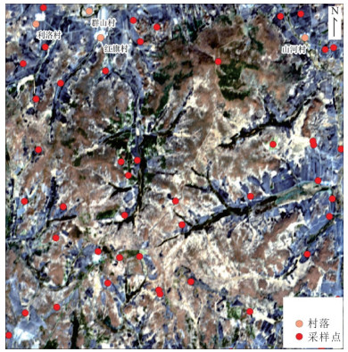
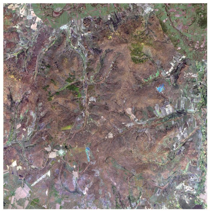
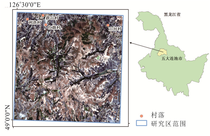
图 2 研究区AHSI真彩色影像及采样点分布
Fig. 2. AHSI image of the study area and distribution of sampling points
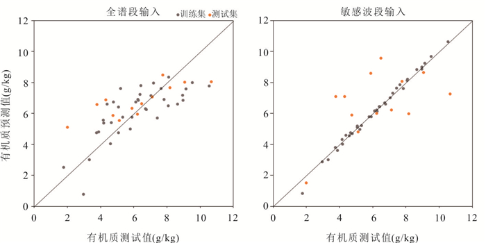
图 6 不同输入的ME-C-CNN模型拟合效果
Fig. 6. Fitting performance of the ME-C-CNN model with different inputs
表 1 资源一号02D卫星AHSI传感器主要参数
Table 1. Key parameters of the AHSI sensor onboard the ZY-1 02D satellite
光谱范围 光谱波段数 空间分辨率 光谱分辨率 幅宽 400~2 500 nm 可见光-近红外 76个 30 m 可见光-近红外 10 nm 60 km 短波红外 90个 短波红外 20 nm  下载: 导出CSV
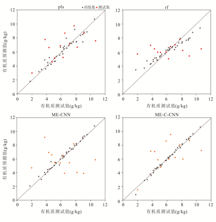
表 2 不同模型的精度指标
Table 2. Accuracy metrics of different models
回归模型 训练集 测试集 R2 RMSE MAE MAPE R2 RMSE MAE MAPE OA PLS 0.92 0.57 0.42 7.14 0.31 1.86 1.44 27.60 53.85 RF 0.88 0.68 0.54 11.30 -0.01 2.26 1.74 37.90 46.15 ME-CNN 0.98 0.29 0.20 4.19 -0.87 3.08 2.49 47.53 30.77 ME-C-CNN 0.98 0.21 0.14 3.49 0.17 2.06 1.64 29.55 38.46
下载: 导出CSV
表 3 不同输入数据的ME-C-CNN模型精度
Table 3. Accuracy of the ME-C-CNN model with different input data
输入数据 训练集 测试集 R2 RMSE MAE MAPE R2 RMSE MAE MAPE OA F1 0.57 1.32 1.11 20.12 0.47 1.63 1.22 29.81 61.54 F2 0.98 0.21 0.14 3.49 0.17 2.06 1.64 29.55 38.46
下载: 导出CSV
表 4 消融实验模型精度
Table 4. Accuracy of models in ablation experiments
编号 多尺度卷积 注意力模块 Ghost模块 跳跃连接 测试集 R2 RMSE MAE MAPE OA M1 √ √ √ √ 0.47 1.63 1.22 29.81 61.54 M2 单尺度 √ √ √ 0.48 1.62 1.22 29.76 61.54 M3 √ × √ √ 0.49 1.60 1.21 28.88 61.54 M4 √ √ × √ 0.51 1.57 1.22 28.51 61.54 M5 √ √ √ × -0.01 2.26 1.79 31.25 46.15 M6 × × × √ 0.42 1.72 1.40 33.86 53.85 M7 √ × × √ 0.51 1.57 1.22 28.55 61.54 M8 单尺度 × √ √ 0.44 1.68 1.26 31.11 61.54 M9 单尺度 √ × √ 0.47 1.63 1.22 29.17 61.54 M10 单尺度 × × √ 0.44 1.68 1.27 31.29 61.54
下载: 导出CSV
-
Angelopoulou, T., Tziolas, N., Balafoutis, A., et al., 2019. Remote Sensing Techniques for Soil Organic Carbon Estimation: A Review. Remote Sensing, 11(6). https://doi.org/10.3390/rs11060676 Bai, Z. J., Chen, S. C., Hong, Y. S., et al., 2023. Estimation of Soil Inorganic Carbon with Visible Near-Infrared Spectroscopy Coupling of Variable Selection and Deep Learning in Arid Region of China. Geoderma, 437: 116589. https://doi.org/10.1016/j.geoderma.2023.116589 Chen, S. C., Richer-de-Forges, A. C., Leatitia Mulder, V., et al., 2021. Digital Mapping of the Soil Thickness of Loess Deposits over a Calcareous Bedrock in Central France. Catena, 198: 105062. https://doi.org/10.1016/j.catena.2020.105062 Chen, C. Q., Dai, H. M., Feng, Y. L., et al., 2022. Sentinel-2A Based Inversion of the Organic Matter Content of Soil in the Sunwu Area. Geophysical and Geochemical Exploration, 46(5): 1141-1148(in Chinese with English abstract). Han, X. Z., Li, N., 2018. Research Progress of Black Soil in Northeast China. Scientia Geographica Sinica, 38(7): 1032-1041(in Chinese with English abstract). İnik, O., İnik, Ö., Öztaş, T., et al., 2023. Prediction of Soil Organic Matter with Deep Learning. Arabian Journal for Science and Engineering, 48(8): 10227-10247. https://doi.org/10.1007/s13369-022-07575-x Li, H. D., Liang, Y. Z., Xu, Q. S., et al., 2009. Key Wavelengths Screening Using Competitive Adaptive Reweighted Sampling Method for Multivariate Calibration. Analytica Chimica Acta, 648(1): 77-84. https://doi.org/10.1016/j.aca.2009.06.046 Li, Y. Y., Li, W., Liu, Y., et al., 2014. Study on the Prediction of Soil Organic Matter Content Based on Hyperspectral Remote Sensing. Chinese Journal of Soil Science, 45(6): 1313-1318(in Chinese with English abstract). Liu, Y., Lu, Y. Y., Chen, D. Y., et al., 2023. Simultaneous Estimation of Multiple Soil Properties under Moist Conditions Using Fractional-Order Derivative of Vis-NIR Spectra and Deep Learning. Geoderma, 438: 116653. https://doi.org/10.1016/j.geoderma.2023.116653 Loiseau, T., Chen, S., Mulder, V. L., et al., 2019. Satellite Data Integration for Soil Clay Content Modelling at a National Scale. International Journal of Applied Earth Observation and Geoinformation, 82: 101905. https://doi.org/10.1016/j.jag.2019.101905 Odebiri, O., Mutanga, O., Odindi, J., 2022. Deep Learning-Based National Scale Soil Organic Carbon Mapping with Sentinel-3 Data. Geoderma, 411: 115695. https://doi.org/10.1016/j.geoderma.2022.115695 Qi, Y. B., Wang, Y. Y., Chen, Y., et al., 2017. Soil Organic Matter Prediction Based on Remote Sensing Data and Random Forest Model in Shaanxi Province. Journal of Natural Resources, 32(6): 1074-1086(in Chinese with English abstract). Shen, Z. F., Ramirez-Lopez, L., Behrens, T., et al., 2022. Deep Transfer Learning of Global Spectra for Local Soil Carbon Monitoring. ISPRS Journal of Photogrammetry and Remote Sensing, 188: 190-200. https://doi.org/10.1016/j.isprsjprs.2022.04.009 Urbina-Salazar, D., Vaudour, E., Richer-de-Forges, A. C., et al., 2023. Sentinel-2 and Sentinel-1 Bare Soil Temporal Mosaics of 6-Year Periods for Soil Organic Carbon Content Mapping in Central France. Remote Sensing, 15(9): 2410. https://doi.org/10.3390/rs15092410 Wadoux, A. M. J., Padarian, J., Minasny, B., 2019. Multi-Source Data Integration for Soil Mapping Using Deep Learning. Soil, 5(1): 107-119. https://doi.org/10.5194/soil-5-107-2019 Wang, J. Y., Yang, W., Wang, Y. C., et al., 2022. A Hyperspectral Prediction Model for Organic Matter Content in Soil Developed from Loess-Like Parent Material in Liaoning Province. Chinese Journal of Soil Science, 53(6): 1320-1330(in Chinese with English abstract). Xu, X. B., Zhai, X. Y., 2023. Mapping Soil Organic Matter Content during the Bare Soil Period by Using Satellite Data and an Improved Deep Learning Network. Sustainability, 15(1): 323. https://doi.org/10.3390/su15010323 Xu, Z., Zhao, X. M., Guo, X., et al., 2019. Deep Learning Application for Predicting Soil Organic Matter Content by VIS-NIR Spectroscopy. Computational Intelligence and Neuroscience, 2019: 3563761. https://doi.org/10.1155/2019/3563761 Yang, P. M., Hu, J., Hu, B. F., et al., 2022. Estimating Soil Organic Matter Content in Desert Areas Using In Situ Hyperspectral Data and Feature Variable Selection Algorithms in Southern Xinjiang, China. Remote Sensing, 14(20): 5221. https://doi.org/10.3390/rs14205221 Zhang, X. L., Lin, T., Xu, J. F., et al., 2019. DeepSpectra: An End-to-End Deep Learning Approach for Quantitative Spectral Analysis. Analytica Chimica Acta, 1058: 48-57. https://doi.org/10.1016/j.aca.2019.01.002 Zhang, L., Cai, Y. Y., Huang, H. L., et al., 2022. A CNN-LSTM Model for Soil Organic Carbon Content Prediction with Long Time Series of MODIS-Based Phenological Variables. Remote Sensing, 14(18): 4441. https://doi.org/10.3390/rs14184441 Zhao, W. D., Wu, Z. L., Yin, Z. D., et al., 2022. Attention-Based CNN Ensemble for Soil Organic Carbon Content Estimation with Spectral Data. IEEE Geoscience and Remote Sensing Letters, 19: 1-5. https://doi.org/10.1109/lgrs.2022.3201266 Zhao, W. D., Wu, Z. L., Yin, Z. D., et al., 2023. Reducing Moisture Effects on Soil Organic Carbon Content Estimation in Vis-NIR Spectra with a Deep Learning Algorithm. IEEE Journal of Selected Topics in Applied Earth Observations and Remote Sensing, 16: 7733-7748. https://doi.org/10.1109/jstars.2023.3287583 Zhao, R., Cui, X. M., Liu, C., 2020. Inversion Estimation of Soil Organic Matter Content Based on GF-5 Hyperspectral Remote Sensing Image. China Environmental Science, 40(8): 3539-3545(in Chinese with English abstract). Zheng, M., Wang, X., Li, S. J., et al., 2022. Remote Sensing Inversion of Soil Organic Matter and Total Nitrogen in Black Soil Region. Scientia Geographica Sinica, 42(8): 1336-1347(in Chinese with English abstract). Zhong, L., Guo, X., Xu, Z., et al., 2021. Soil Properties: Their Prediction and Feature Extraction from the LUCAS Spectral Library Using Deep Convolutional Neural Networks. Geoderma, 402: 115366. https://doi.org/10.1016/j.geoderma.2021.115366 陈超群, 戴慧敏, 冯雨林, 等, 2022. 基于Sentinel-2A的孙吴地区土壤有机质反演研究. 物探与化探, 46(5): 1141-1148. 韩晓增, 李娜, 2018. 中国东北黑土地研究进展与展望. 地理科学, 38(7): 1032-1041. 李媛媛, 李微, 刘远, 等, 2014. 基于高光谱遥感土壤有机质含量预测研究. 土壤通报, 45(6): 1313-1318. 齐雁冰, 王茵茵, 陈洋, 等, 2017. 基于遥感与随机森林算法的陕西省土壤有机质空间预测. 自然资源学报, 32(6): 1074-1086. 王荐一, 杨雯, 王玉川, 等, 2022. 辽宁省黄土状母质发育土壤有机质含量高光谱预测模型的构建. 土壤通报, 53(6): 1320-1330. 赵瑞, 崔希民, 刘超, 2020. GF-5高光谱遥感影像的土壤有机质含量反演估算研究. 中国环境科学, 40(8): 3539-3545. 郑淼, 王翔, 李思佳, 等, 2022. 黑土区土壤有机质和全氮含量遥感反演研究. 地理科学, 42(8): 1336-1347. -

 点击查看大图
计量
- 文章访问数: 97
- HTML全文浏览量: 12
- PDF下载量: 9
- 被引次数: 0
