


Lightweight Deep Learning for Cross-Scene Landslide Intelligent Recognition with Multi-Source Feature Fusion
-
摘要: 极端环境因素影响下诱发的区域性滑坡对生命财产安全构成严重威胁. 因此,推进区域性滑坡识别的自动化,提升复杂地形下隐患区域的信息透明度,对地质灾害数据库建设和风险管理至关重要. 深度学习方法提供了有效的解决方案,克服了传统方法自动化程度不足的问题. 然而,现有研究多侧重于模型结构优化与训练策略改进,在多源地形数据的有效融合与跨区域识别能力提升方面仍存在挑战. 针对上述瓶颈,提出了一种具有跨区域识别能力的深度学习ResU-CBNet模型. 该模型将空间和通道混合的注意力机制融入神经网络模型,并采用残差网络替换原有普通网络结构. 模型在多尺度特征融合条件下的性能显著优于单一遥感数据,具体表现为PA、CPA、F1_Score、MIoU分别提升2.1%、2.6%、6.9%、2.9%;同时,模型在不同场景、不同光谱波段和空间分布的区域中验证了其跨场景泛化能力,PA和F1_Score分别达到了92.8%、91.3%和83.2%、80.0%的性能,识别效果与实际区域高度吻合.提出的跨场景的识别方法可为滑坡智能识别和风险评估提供一定的参考.Abstract: Regional-scale landslides triggered by extreme environmental factors pose a significant threat to life and property safety. Consequently, advancing the automation of regional landslide identification and enhancing the information transparency of potential hazard zones in complex terrain are paramount for the construction of geological hazard databases and effective risk management.Deep learning methods provide an effective solution, overcoming the problem of insufficient automation in traditional methods. However, existing research primarily focuses on optimizing model architecture and improving training strategies, leaving challenges in the effective fusion of multi-source topographic data and the enhancement of cross-regional identification capability. To address these bottlenecks, this paper proposes ResU-CBNet, a deep learning model with robust cross-regional identification capability. The model integrates a hybrid spatial and channel attention mechanism into the neural network and utilizes a residual network to replace the conventional network structure. The model's performance under multi-scale feature fusion conditions significantly outperforms that of single remote sensing data, specifically showing improvements of 2.1% in PA, 2.6% in CPA, 6.9% in F1_Score, and 2.9% in MIoU.Furthermore, the model validates its cross-scene generalization capability across regions with different scenarios, spectral bands, and spatial distributions, achieving PA and F1_Score performances of 92.8%, 91.3% and 83.2%, 80.0%, respectively. The identification results demonstrate a high degree of consistency with the actual regions.The cross-scene identification method presented here offers a valuable reference for intelligent landslide recognition and risk assessment.
-
Key words:
- deep Learning /
- multi-source data /
- attention mechanism /
- landslide recognition /
- cross-scene
-
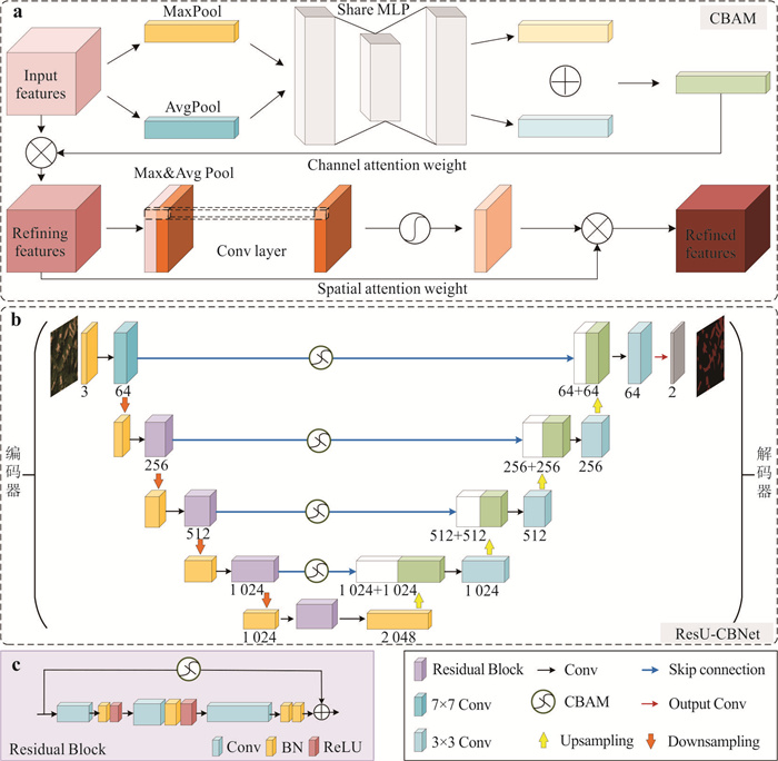
图 4 残差网络、卷积注意力机制与ResU-CBNet模型
Fig. 4. Residual network, convolutional attention mechanism and ResU-CBNet model
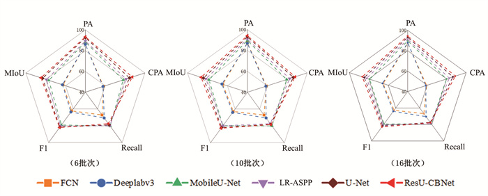
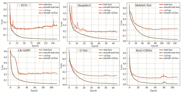
图 6 不同batch size下模型间性能对比
Fig. 6. Comparison of performance between models under different batches
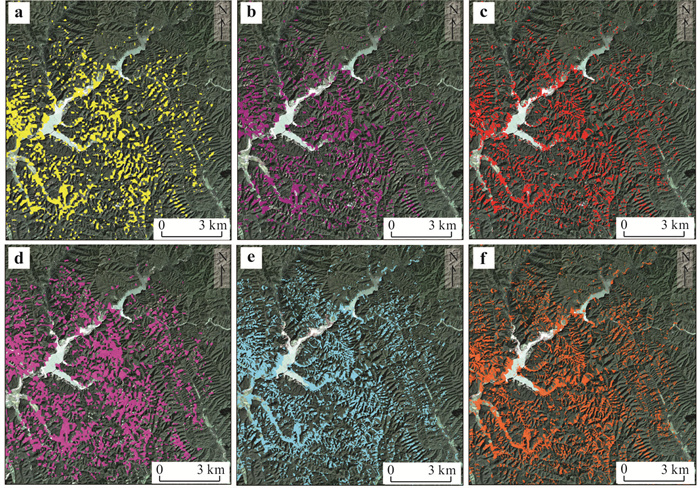
图 8 预测区域不同模型的识别效果
Fig. 8. Recognition effect of different models in the prediction region
a. FCN; b. Deeplabv3; c. LR-ASPP; d. U-Net (MobileNet); e. U-net; f. ResU-CBNet
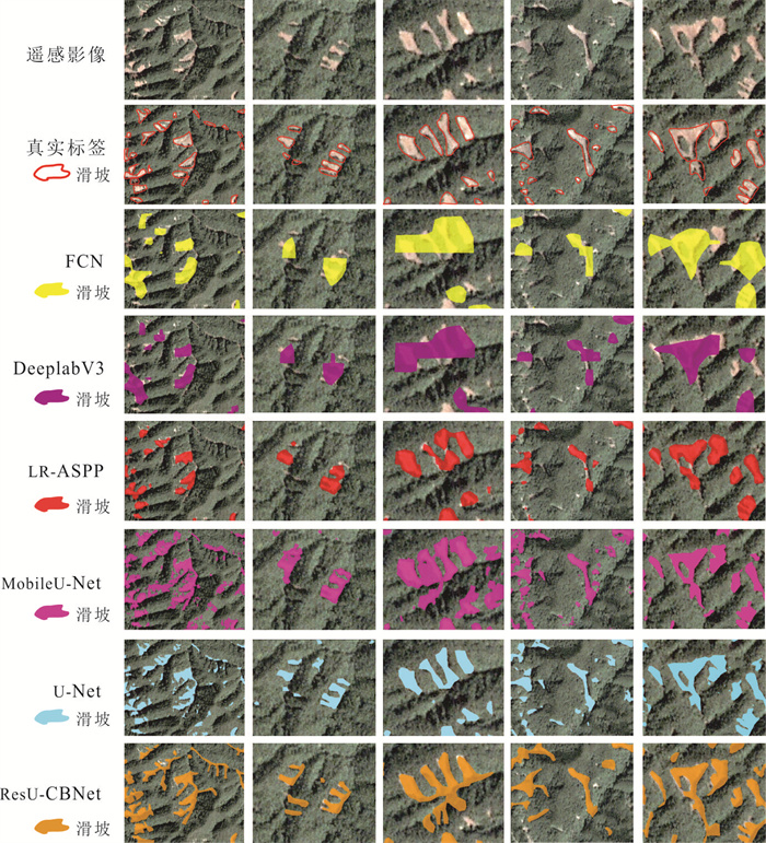
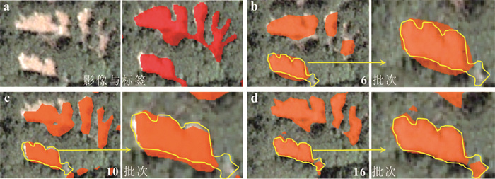
图 9 不同模型滑坡识别局部效果对比
Fig. 9. Comparison of local effects of landslide recognition of different models

图 10 多源数据输入下各模型的识别效果
Fig. 10. The recognition effect of each model under multi-source data input
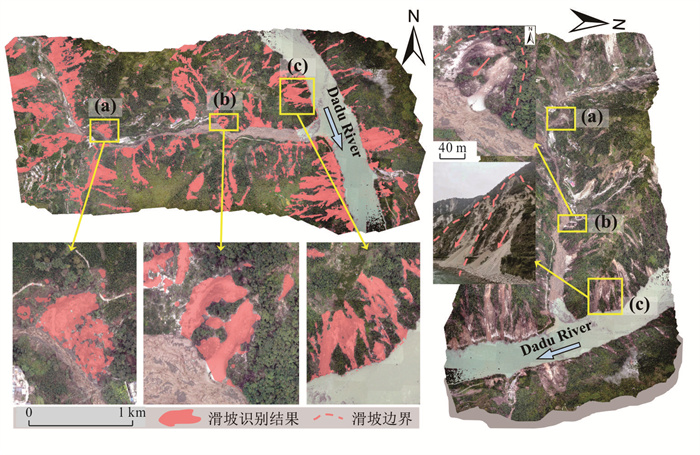
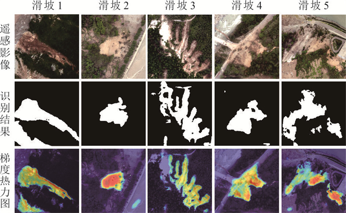
图 12 基于ResU-CBNet算法的泸定地震滑坡识别结果
Fig. 12. Landslide identification results of Luding earthquake based on ResU-CBNet algorithm
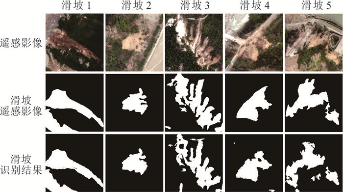
图 13 基于ResU-CBNet模型的四川周边滑坡识别结果
Fig. 13. Landslide identification results around Sichuan based on Res-CBNet model

图 15 滑坡智能识别的多物理场信息融合框架
Fig. 15. Framework for multi-source physical field fusion in intelligent landslide detection
表 1 区域滑坡识别数据来源
Table 1. Regional landslide identification data sources
数据名称 数据来源 公开时间(年份) 数据类型 毕节公开滑坡数据集 http://gpcv.whu.edu.cn/data/Bijie_pages.html 2020 栅格(0.8 m) 北海道卫星遥感影像 Planet Labs 2018 栅格(3 m) 地层岩性 Geological Survey of Japan(GSJ) 1990 矢量(1∶100 000) 断层数据 Geological Survey of Japan(GSJ) 1995 矢量(1∶100 000) DEM Geospatial Information Authority of Japan(GSI) 2018 栅格(10 m) 坡度、坡向、曲率、水系数据 DEM 2018 栅格(10 m) 峰值地面加速度(Peak Ground Velocity, PGA) 美国地质调查局(United States Geological Survey, USGS) 2018 栅格(10 m)  下载: 导出CSV
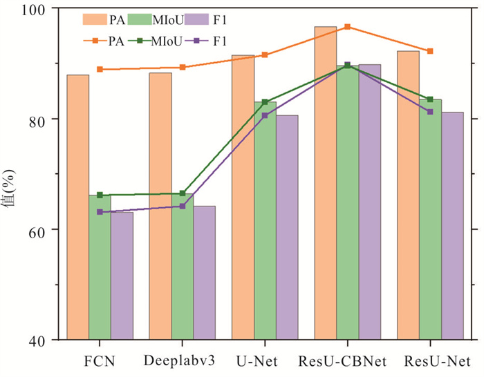
表 2 批量大小为6、10和16时的不同模型识别效果
Table 2. Different model recognition effects at batch sizes of 6, 10, and 16
batch size 模型 PA(%) CPA(%) recall(%) F1_Score(%) MIoU(%) 6 FCN 0.862 0.583 0.671 0.623 0.625 Deeplabv3 0.861 0.578 0.707 0.636 0.631 (U-Net)MobileNet 0.884 0.781 0.803 0.791 0.769 LR-ASPP 0.893 0.811 0.799 0.804 0.686 U-Net 0.925 0.845 0.789 0.816 0.832 ResU-CBNet 0.934 0.873 0.775 0.821 0.848 10 FCN 0.873 0.591 0.670 0.628 0.647 Deeplabv3 0.869 0.586 0.704 0.639 0.655 (U-Net)MobileNet 0.895 0.794 0.799 0.796 0.785 LR-ASPP 0.908 0.824 0.772 0.797 0.698 U-Net 0.930 0.861 0.779 0.818 0.841 ResU-CBNet 0.942 0.879 0.782 0.827 0.864 16 FCN 0.874 0.594 0.668 0.628 0.652 Deeplabv3 0.878 0.586 0.705 0.640 0.659 (U-Net)MobileNet 0.897 0.798 0.791 0.794 0.791 LR-ASPP 0.911 0.827 0.789 0.807 0.702 U-Net 0.932 0.864 0.775 0.817 0.846 ResU-CBNet 0.945 0.888 0.779 0.829 0.867
下载: 导出CSV
表 3 ResU-CBNet模型在不同数据组合输入下的识别对比
Table 3. Comparison of the recognition of the ResU-CBNet model under different data combination inputs
PA (%) CPA(%) recall(%) F1_Score(%) MIoU(%) 第一组(仅光学数据) 0.945 0.888 0.779 0.829 0.867 第二组(仅地形数据) 0.714 0.569 0.416 0.481 0.519 第三组(多源数据) 0.966 0.914 0.884 0.898 0.896
下载: 导出CSV
表 4 对比不同模型在多源数据输入下的识别结果
Table 4. Compare the recognition results of different models under multi-source data input
网络模型 PA(%) CPA(%) recall(%) F1_Score(%) MIoU(%) FCN 0.889 0.601 0.664 0.631 0.662 Deeplabv3 0.893 0.593 0.701 0.642 0.665 U-Net 0.934 0.879 0.765 0.818 0.849 ResU-CBNet 0.966 0.914 0.884 0.898 0.896 ResU-Net 0.939 0.894 0.795 0.842 0.865
下载: 导出CSV
表 5 北海道和四川地区地质条件特征对比
Table 5. Comparative analysis of geological settings in Hokkaido and Sichuan
特征 北海道 四川 诱发机制 地震和强降雨 降雨主导和局部地震 主要岩性 火山岩、安山岩、页岩 板岩、砂岩、片麻岩 地貌特征 多断层构造、起伏大、崩塌明显 高山峡谷、坡体高差大 气候类型 温带海洋性气候 高原季风气候 植被覆盖 中等至高 高覆盖,滑坡边界识别难 触发条件时空尺度 单次强震和集中强降雨 多时相降雨诱发和潜伏期滑坡活化
下载: 导出CSV
表 6 基于ResU-CBNet模型的泸定与四川区域滑坡识别效果
Table 6. Performance of ResU-CBNet for Landslide Identification in Luding and Sichuan
区域 PA(%) CPA(%) recall(%) F1(%) MIoU(%) 泸定地震诱发滑坡 0.928 0.781 0.890 0.832 0.812 四川滑坡数据集 0.913 0.742 0.865 0.800 0.780
下载: 导出CSV
-
Baghbani, A., Choudhury, T., Costa, S., et al., 2022. Application of Artificial Intelligence in Geotechnical Engineering: a State-of-the-Art Review. Earth-Science Reviews, 228: 103991. https://doi.org/10.1016/j.earscirev.2022.103991 Chen, H. S., He, Y., Zhang, L. F., et al., 2024. A Multi-Input Channel U-Net Landslide Detection Method Fusing SAR Multisource Remote Sensing Data. IEEE Journal of Selected Topics in Applied Earth Observations and Remote Sensing, 17: 1215-1232. https://doi.org/10.1109/JSTARS.2023.3339294 Chen, L. C., Papandreou, G., Schroff, F., et al., 2017. Rethinking Atrous Convolution for Semantic Image Segmentation. arXiv preprint, 1706.05587. https://doi.org/10.48550/arXiv.1706.05587 Cheng, L. B., Li, J., Duan, P., et al., 2021. A Small Attentional YOLO Model for Landslide Detection from Satellite Remote Sensing Images. Landslides, 18(8): 2751-2765. https://doi.org/10.1007/s10346-021-01694-6 Dong, A. N., Dou, J., Li, C. D., et al., 2024. Accelerating Cross-Scene Co-Seismic Landslide Detection through Progressive Transfer Learning and Lightweight Deep Learning Strategies. IEEE Transactions on Geoscience and Remote Sensing, 62: 4410213. https://doi.org/10.1109/TGRS.2024.3424680 Dou, J., Xiang, Z. L., Xu, Q., et al., 2023. Application and Development Trend of Machine Learning in Landslide Intelligent Disaster Prevention and Mitigation. Earth Science, 48(5): 1657-1674(in Chinese with English abstract). Dou, J., Xing, K., Wang, L. Z., et al., 2025. Air-Space-Ground Synergistic Observations for Rapid Post-Seismic Disaster Assessment of 2025 Ms6.8 Xigazê Earthquake, Xizang. Journal of Earth Science, 36(4): 1605-1622. https://doi.org/10.1007/s12583-025-0160-2 Dou, J., Yunus, A. P., Bui, D. T., et al., 2020. Improved Landslide Assessment Using Support Vector Machine with Bagging, Boosting, and Stacking Ensemble Machine Learning Framework in a Mountainous Watershed, Japan. Landslides, 17(3): 641-658. https://doi.org/10.1007/s10346-019-01286-5 Dou, J., Yunus, A. P., Bui, D. T., et al., 2019. Assessment of Advanced Random Forest and Decision Tree Algorithms for Modeling Rainfall-Induced Landslide Susceptibility in the Izu-Oshima Volcanic Island, Japan. Science of the Total Environment, 662: 332-346. https://doi.org/10.1016/j.scitotenv.2019.01.221 Fan, R. S., Chen, Y., Xu, Q. H., et al., 2019. A High-Resolution Remote Sensing Image Building Extraction Method Based on Deep Learning. Acta Geodaetica et Cartographica Sinica, 48(1): 34-41(in Chinese with English abstract). Guo, Z. Z., Cheng, M. C., Wang, Y. G., et al., 2025a. Landslide Hazard Prediction under an Extreme Rainfall Scenario by Considering Multiple Timescale Rainfalls and Effective Recharge. Georisk: Assessment and Management of Risk for Engineered Systems and Geohazards, 19(4): 775-803. https://doi.org/10.1080/17499518. 2025. 2570863 doi: 10.1080/17499518.2025.2570863 Guo, Z. Z., Zeng, T. R., Zhang, Y. H., et al., 2025b. A Novel Hybrid Model Integrating High Resolution Remote Sensing and Stacking Ensemble Techniques for Landslide Susceptibility Mapping: Application to Event-Based Landslide Inventory. Geomorphology, 486: 109886. https://doi.org/10.1016/j.geomorph.2025.109886 He, Y. J., Dou, J., Wang, X. K., et al., 2024. Comparison on the Application of the Software for Image-Free Control UAV Data Processing of Digital Landslide: a Case Study of Huangtupo Landslide in the Three Gorges Reservoir Area. The Chinese Journal of Geological Hazard and Control, 35(5): 160-173(in Chinese with English abstract). Howard, A., Sandler, M., Chu, G., et al., 2019. Searching for MobileNetV3. IEEE, 2020. https://doi.org/10.1109/ICCV.2019.00140 Ju, Y. Z., Xu, Q., Jin, S. C., et al., 2020. Automatic Object Detection of Loess Landslide Based on Deep Learning. Geomatics and Information Science of Wuhan University, 45(11): 1747-1755(in Chinese with English abstract). Liu, X. R., Peng, Y. X., Lu, Z. L., et al., 2023. Feature-Fusion Segmentation Network for Landslide Detection Using High-Resolution Remote Sensing Images and Digital Elevation Model Data. IEEE Transactions on Geoscience and Remote Sensing, 61: 4500314. https://doi.org/10.1109/TGRS.2022.3233637 Long, J., Shelhamer, E., Darrell, T., 2015. Fully Convolutional Networks for Semantic Segmentation. 2015 IEEE Conference on Computer Vision and Pattern Recognition (CVPR). June 7-12, 2015, Boston, MA, USA. IEEE: 3431-3440. https://doi.org/10.1109/CVPR.2015.7298965 Mao, J. Q., He, J., Liu, G., et al., 2023. Landslide Recognition Based on Improved DeepLabV3+ Algorithm. Journal of Natural Disasters, 32(2): 227-234(in Chinese with English abstract). Osanai, N., Yamada, T., Hayashi, S. I., et al., 2019. Characteristics of Landslides Caused by the 2018 Hokkaido Eastern Iburi Earthquake. Landslides, 16(8): 1517-1528. https://doi.org/10.1007/s10346-019-01206-7 Ronneberger, O., Fischer, P., Brox, T., 2015. U-Net: Convolutional Networks for Biomedical Image Segmentation. Medical Image Computing and Computer-Assisted Intervention: MICCAI 2015. Cham: SpringerInternationalPublishing: 234-241. https://doi.org/10.1007/978-3-319-24574-4_28 Selvaraju, R. R., Cogswell, M., Das, A., et al., 2017. Grad-CAM: Visual Explanations from Deep Networks via Gradient-Based Localization. 2017 IEEE International Conference on Computer Vision (ICCV). October 22-29, 2017, Venice, Italy. IEEE: 618-626. https://doi.org/10.1109/ICCV.2017.74 Shafiq, M., Gu, Z. Q., 2022. Deep Residual Learning for Image Recognition: a Survey. Applied Sciences, 12(18): 8972. https://doi.org/10.3390/app12188972 Tang, H. M., Li, C. D., Hu, W., et al., 2022. What Is the Physical Mechanism of Major Landslides? Earth Science, 47(10): 3902-3903(in Chinese with English abstract). Wang, H. H., Liu, J., Zeng, S. K., et al., 2024a. A Novel Landslide Identification Method for Multi-Scale and Complex Background Region Based on Multi-Model Fusion: YOLO + U-Net. Landslides, 21(4): 901-917. https://doi.org/10.1007/s10346-023-02184-7 Wang, Q. Y., Tang, H. M., An, P. J., et al., 2024b. Insight into the Permeability and Microstructure Evolution Mechanism of the Sliding Zone Soil: a Case Study from the Huangtupo Landslide, Three Gorges Reservoir, China. Journal of Earth Science, 35(3): 941-954. https://doi.org/10.1007/s12583-023-1828-0 Wang, X. M., Yin, J., Luo, M. H., et al., 2023. Active High-Locality Landslides in Mao County: Early Identification and Deformational Rules. Journal of Earth Science, 34(5): 1596-1615. https://doi.org/10.1007/s12583-021-1505-0 Woo, S., Park, J., Lee, J. Y., et al., 2018. CBAM: Convolutional Block Attention Module. In: Ferrari, V., Hebert, M., Sminchisescu, C., Weiss, Y., eds., Computer Vision-ECCV 2018. ECCV 2018. Lecture Notes in Computer Science, 11211. Springer, Cham. https://doi.org/10.1007/978-3-030-01234-2_1 .Wu, Z. B., Li, H., Yuan, S. X., et al., 2023. Mask R-CNN-Based Landslide Hazard Identification for 22.6 Extreme Rainfall Induced Landslides in the Beijiang River Basin, China. Remote Sensing, 15(20): 4898. https://doi.org/10.3390/rs15204898 Xiang, X. Y., Gong, W. P., Li, S. L., et al., 2024. TCNet: Multiscale Fusion of Transformer and CNN for Semantic Segmentation of Remote Sensing Images. IEEE Journal of Selected Topics in Applied Earth Observations and Remote Sensing, 17: 3123-3136. https://doi.org/10.1109/JSTARS.2024.3349625 Xing, K., Dou, J., Chen, N. C., et al., 2025. Landslide Feature Interpretation and Stability Assessment Using Optical-LiDAR Synergy and High-Resolution 3D Modeling. Journal of Natural Disasters, 34(3): 119-132(in Chinese with English abstract). Xing, K., Li, H., Zhang, L. L., et al., 2025. Analysis of Surface Rupture and Seismic Damage Characteristics of 2025 Dingri Ms6.8 Earthquake in Xizang. Safety and Environmental Engineering, 32(2): 20-30(in Chinese with English abstract). Xu, Q. S., Ouyang, C. J., Jiang, T. H., et al., 2022. MFFENet and ADANet: a Robust Deep Transfer Learning Method and Its Application in High Precision and Fast Cross-Scene Recognition of Earthquake-Induced Landslides. Landslides, 19(7): 1617-1647. https://doi.org/10.1007/s10346-022-01847-1 Xu, Q., Dong, X. J., Zhu, X., et al., 2023. Landslide Collaborative Observation Technology Based on Real Scene 3D View from Space-Air-Ground-Interior Perspective. Journal of Engineering Geology, 31(3): 706-717(in Chinese with English abstract). Yang, Y. C., Dou, J., Merghadi, A., et al., 2024a. Advanced Prediction of Landslide Deformation through Temporal Fusion Transformer and Multivariate Time-Series Clustering of InSAR: Insights from the Badui Region, Eastern Tibet. IEEE Transactions on Geoscience and Remote Sensing, 62: 4514219. https://doi.org/10.1109/TGRS. 2024.3504241 doi: 10.1109/TGRS.2024.3504241 Yang, Y. H., Miao, Z. L., Zhang, H., et al., 2024b. Lightweight Attention-Guided YOLO with Level Set Layer for Landslide Detection from Optical Satellite Images. IEEE Journal of Selected Topics in Applied Earth Observations and Remote Sensing, 17: 3543-3559. https://doi.org/10.1109/JSTARS.2024.3351277 Yang, Z. Q., Xu, C., 2022. Efficient Detection of Earthquake-Triggered Landslides Based on U-Net++: an Example of the 2018 Hokkaido Eastern Iburi (Japan) Mw=6.6 Earthquake. Remote Sensing, 14(12): 2826. https://doi.org/10.3390/rs14122826 Yin, Y. P., Gao, S. H., 2024. Research on High-Altitude and Long-Runout Rockslides: Review and Prospects. The Chinese Journal of Geological Hazard and Control, 35(1): 1-18(in Chinese with English abstract). Zhang, S. S., Li, Q. C., Li, H., et al., 2025. Intelligent Glacial Lake Identification in Complex Plateau Terrain Regions Using Multi-Source Remote Sensing Data and Mask R-CNN Deep Learning Model. Earth Science, 50(8): 3132-3143(in Chinese with English abstract). Zhang, Z. X., Liu, Q. J., Wang, Y. H., 2018. Road Extraction by Deep Residual U-Net. IEEE Geoscience and Remote Sensing Letters, 15(5): 749-753. https://doi.org/10.1109/LGRS.2018.2802944 窦杰, 向子林, 许强, 等, 2023. 机器学习在滑坡智能防灾减灾中的应用与发展趋势. 地球科学, 48(5): 1657-1674. doi: 10.3799/dqkx.2022.419 范荣双, 陈洋, 徐启恒, 等, 2019. 基于深度学习的高分辨率遥感影像建筑物提取方法. 测绘学报, 48(1): 34-41. 何雨健, 窦杰, 王协康, 等, 2024. 国内外免像控无人机航测软件在数字滑坡中的应用效果对比: 以三峡库区黄土坡滑坡为例. 中国地质灾害与防治学报, 35(5): 160-173. 巨袁臻, 许强, 金时超, 等, 2020. 使用深度学习方法实现黄土滑坡自动识别. 武汉大学学报(信息科学版), 45(11): 1747-1755. 毛佳琪, 何敬, 刘刚, 等, 2023. 基于改进的DeepLabV3+算法滑坡识别. 自然灾害学报, 32(2): 227-234. 唐辉明, 李长冬, 胡伟, 等, 2022. 重大滑坡启滑的物理机制是什么?地球科学, 47(10): 3902-3903. doi: 10.3799/dqkx.2022.857 邢珂, 黎昊, 张乐乐, 等, 2025a. 2025年西藏定日Ms6.8地震地表破裂与震害特征分析. 安全与环境工程, 32(2): 20-30. 邢珂, 窦杰, 陈能成, 等, 2025b. 基于光学-LiDAR协同遥感及三维精细建模的滑坡特征解译与稳定性评价. 自然灾害学报, 34(3): 119-132. 许强, 董秀军, 朱星, 等, 2023. 基于实景三维的天-空-地-内滑坡协同观测. 工程地质学报, 31(3): 706-717. 殷跃平, 高少华, 2024. 高位远程地质灾害研究: 回顾与展望. 中国地质灾害与防治学报, 35(1): 1-18. 张世殊, 李青春, 黎昊, 等, 2025. 融合多源遥感数据和改进后Mask R-CNN深度学习模型的复杂高原地形区冰湖智能识别. 地球科学, 50(8): 3132-3143. doi: 10.3799/dqkx.2025.041 -

 点击查看大图
计量
- 文章访问数: 403
- HTML全文浏览量: 17
- PDF下载量: 34
- 被引次数: 0
