


Three-Dimensional Deformation and River Blocking Effects of Landslides in the Upper Jinsha River Revealed by SBAS-InSAR
-
摘要:
利用SBAS-InSAR技术处理了2014—2022年间Sentinel-1A升降轨SAR数据,重点研究了白格滑坡堵江事件对其下游最近临滑坡群活动性的影响.选择受堵江影响显著的沙东滑坡进行了地形约束下的InSAR三维形变反演,并结合GNSS监测验证模型性能.研究结果显示,白格滑坡堵江后,沿岸滑坡的形变速率普遍增加了3~7倍不等.特别是位于金沙江凹岸的沙东滑坡,单体受影响面积约1.85 km2,最快变形速率增加了堵江前的7倍.三维形变结果表明,相较于地表平行流(Surface-Parallel Flow,SPF)模型,坡向平行流(Aspect Parallel Flow,APF)地形约束模型在沙东滑坡三维形变反演中的表现更优.
-
关键词:
- SBAS-InSAR /
- 三维形变 /
- 白格滑坡 /
- 堵江影响 /
- 工程地质学
Abstract:This study employs the SBAS-InSAR technique to process Sentinel-1A ascending and descending orbit SAR data from 2014 to 2022, focusing on the impact of the Baige landslide-induced river damming event on the activity of the nearest downstream landslide cluster. The Shadong landslide, which was significantly affected by the damming, was selected for terrain-constrained three-dimensional (3D) deformation inversion using InSAR, with GNSS observations used to validate model performance. Results indicate that, following the damming event, deformation rates of the riverside landslides generally increased by a factor of 3 to 7. In particular, the Shadong landslide, located on the concave bank of the Jinsha River, exhibited a notably impacted area of approximately 1.85 km2, with the maximum deformation rate increasing up to 7 times compared to the pre-damming period. The 3D deformation analysis demonstrates that the Aspect-Parallel Flow (APF) terrain-constrained model outperforms the Surface-Parallel Flow (SPF) model in reconstructing the deformation pattern of the Shadong landslide.
-
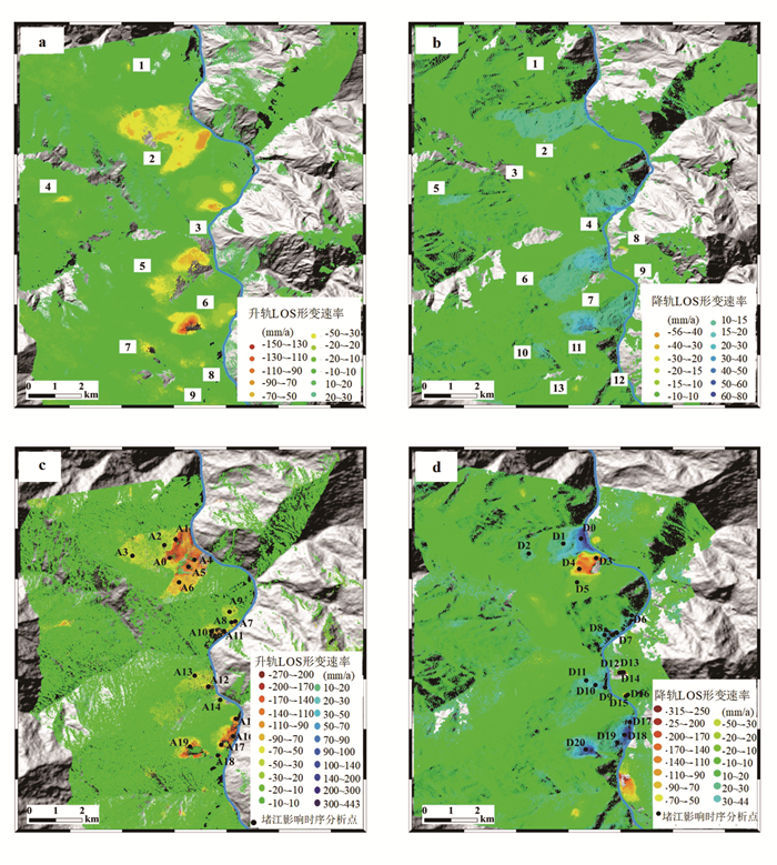
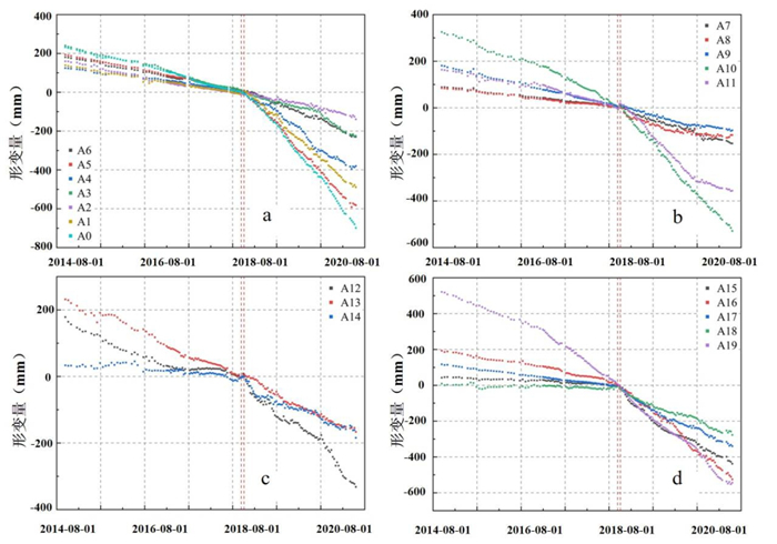
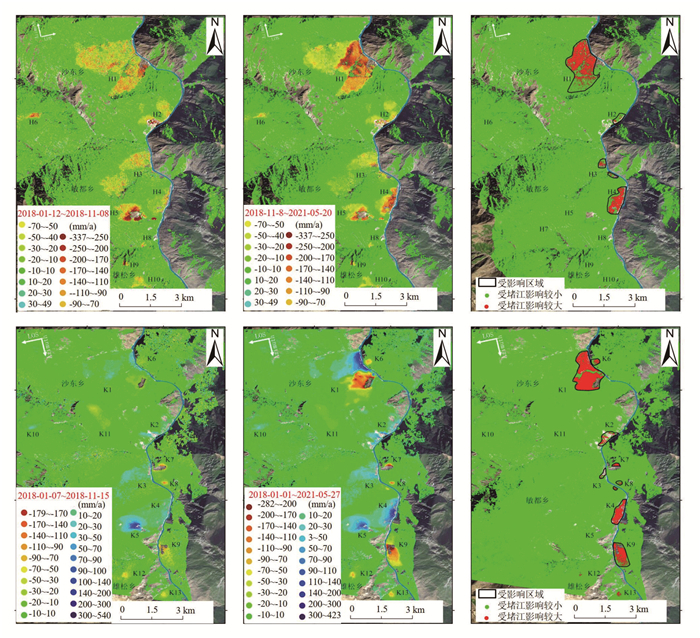
图 2 SBAS-InSAR监测结果
图a和图b为2014年10月至2018年10月的升、降轨监测结果;图c和图d为2018年01月至2021年05月的升、降轨监测结果
Fig. 2. Monitoring results of SBAS-InSAR
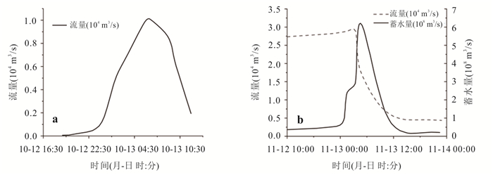
图 3 堵江堰塞湖第1次泄洪流量(a);第2次泄洪流量(b)
Fig. 3. The outburst-flood discharge flow of the dammed lake for the first time (a) and sencond time (b)
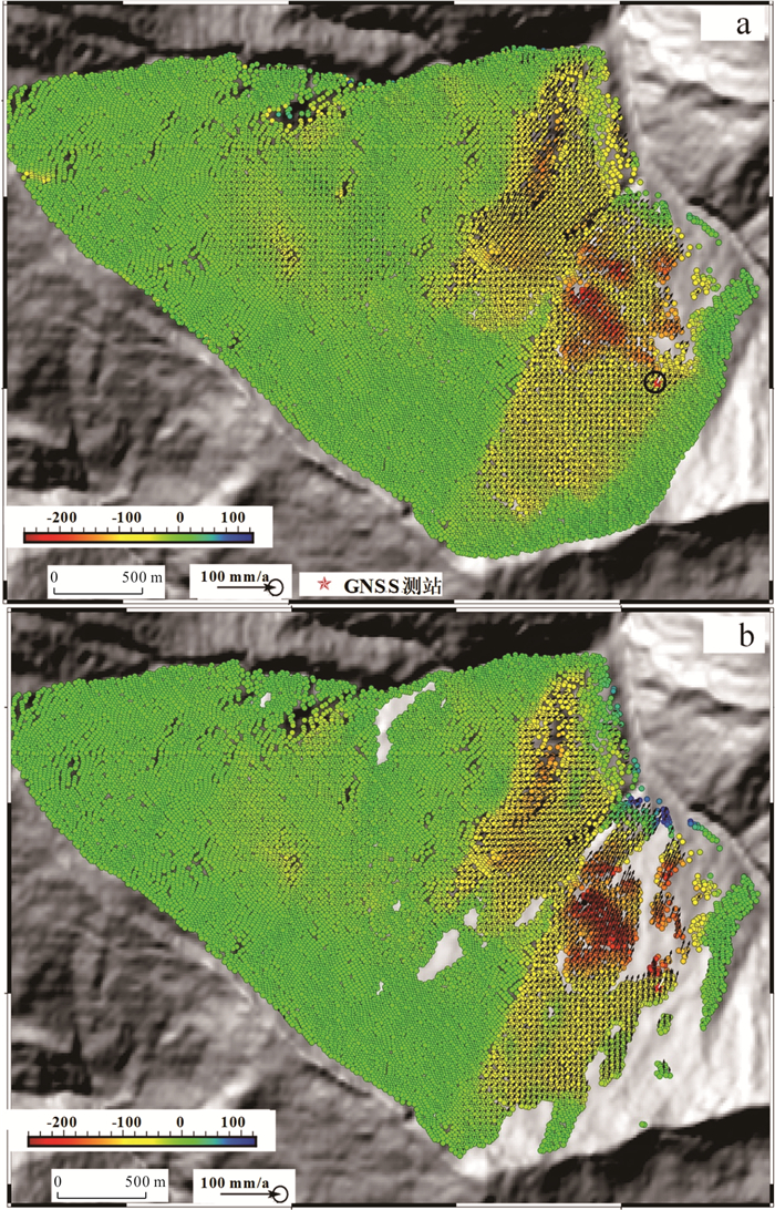
图 7 2018年6月~2022年5月SPF和APF约束下的三维形变速率
Fig. 7. Three-dimensional deformation rates under SPF and APF constraints
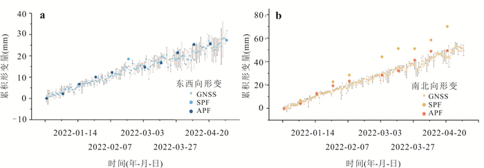
图 8 水平方向累积形变结果
a.E-W向累积形变;b. N-S向累积形变
Fig. 8. The cumulative deformation in horizontal direction
表 1 Sentinel-1A SAR影像参数
Table 1. The parameters of Sentinel-1A SAR imagery
轨道方向 升轨 降轨 雷达入射角(°) 36.8 42.3 卫星飞行方位角(°) -12.5 192.5 数据量(景) 82/100/110 76/99/118 时段Ⅰ 2014-10-12~2018-10-27 2014-10-07~2018-09-28 时段Ⅱ 2018-01-12~2021-05-20 2018-01-07~2021-05-27 时段Ⅲ 2018-06-05~2022-05-03 2018-06-12~2022-05-22  下载: 导出CSV
表 2 水平方向年均形变速率对比
Table 2. Comparsion of the annual average deformation rates in horizontal direction
SPF APF GNSS SPF误差 APF误差 东西向(mm/a) 75.31 74.72 82.07 6.73 7.35 南北向(mm/a) 198.21 124.43 137.00 81.21 9.57 水平面夹角(°) 20.80 28.74 30.92 11.88 0.53
下载: 导出CSV
-
Berardino, P., Fornaro, G., Lanari, R., et al., 2002. A New Algorithm for Surface Deformation Monitoring Based on Small Baseline Differential SAR Interferograms. IEEE Transactions on Geoscience and Remote Sensing, 40(11): 2375-2383. https://doi.org/10.1109/TGRS.2002.803792 Chai, H. J., Liu, H. C., Zhang, Z. Y., 2000. Development and Distribution Characteristics of Dujiang Landslide in China. Mountain Research, 18(S1): 51-54 (in Chinese with English abstract). Chen, J. P., Li, H. Z., 2016. Genetic Mechanism and Disasters Features of Complicated Structural Rock Mass along the Rapidly Uplift Section at the Upstream of Jinsha River. Journal of Jilin University (Earth Science Edition), 46(4): 1153-1167 (in Chinese with English abstract). Evans, S. G., Delaney, K. B., Hermanns, R. L., et al., 2011. The Formation and Behaviour of Natural and Artificial Rockslide Dams; Implications for Engineering Performance and Hazard Management. Natural and Artificial Rockslide Dams. Springer Berlin Heidelberg, Berlin, Heidelberg, 1-75. https://doi.org/10.1007/978-3-642-04764-0_1 Fan, X. M., Dufresne, A., Siva Subramanian, S., et al., 2020. The Formation and Impact of Landslide Dams – State of the Art. Earth-Science Reviews, 203: 103116. https://doi.org/10.1016/j.earscirev.2020.103116 Fan, X. M., Xu, Q., Alonso-Rodriguez, A., et al., 2019. Successive Landsliding and Damming of the Jinsha River in Eastern Tibet, China: Prime Investigation, Early Warning, and Emergency Response. Landslides, 16(5): 1003-1020. https://doi.org/10.1007/s10346-019-01159-x Franco, A., Moernaut, J., Schneider-Muntau, B., et al., 2021. Triggers and Consequences of Landslide-Induced Impulse Waves–3D Dynamic Reconstruction of the Taan Fiord 2015 Tsunami Event. Engineering Geology, 294: 106384. https://doi.org/10.1016/j.enggeo.2021.106384 Guo, C. B., Wu, R. A., Zhong, N., et al., 2024. Large Landslides along Active Tectonic Zones of Eastern Tibetan Plateau: Background and Mechanism of Landslide Formation. Earth Science, 49(12): 4635-4658 (in Chinese with English abstract). Guo, C. B., Yan, Y. Q., Zhang, Y. S., et al., 2021. Study on the Creep-Sliding Mechanism of the Giant Xiongba Ancient Landslide Based on the SBAS-InSAR Method, Tibetan Plateau, China. Remote Sensing, 13(17): 3365. https://doi.org/10.3390/rs13173365 Hu, X., Lu, Z., Pierson, T. C., et al., 2018. Combining InSAR and GPS to Determine Transient Movement and Thickness of a Seasonally Active Low-Gradient Translational Landslide. Geophysical Research Letters, 45(3): 1453-1462. https://doi.org/10.1002/2017GL076623 Joughin, I. R., Kwok, R., Fahnestock, M. A., 1998. Interferometric Estimation of Three-Dimensional Ice-Flow Using Ascending and Descending Passes. IEEE Transactions on Geoscience and Remote Sensing, 36(1): 25-37. https://doi.org/10.1109/36.655315 Li, M. H., Zhang, L., Ding, C., et al., 2020. Retrieval of Historical Surface Displacements of the Baige Landslide from Time-Series SAR Observations for Retrospective Analysis of the Collapse Event. Remote Sensing of Environment, 240: 111695. https://doi.org/10.1016/j.rse.2020.111695 Li, X., Guo, C. B., Yang, Z. H., et al., 2021. Development Characteristics and Formation Mechanism of the Xiongba Giant Ancient Landslide in the Jinshajiang Tectonic Zone. Geoscience, 35(1): 47-55 (in Chinese with English abstract). Liu, X. J., Zhao, C. Y., Zhang, Q., et al., 2021a. Integration of Sentinel-1 and ALOS/PALSAR-2 SAR Datasets for Mapping Active Landslides along the Jinsha River Corridor, China. Engineering Geology, 284: 106033. https://doi.org/10.1016/j.enggeo.2021.106033 Liu, X. J., Zhao, C. Y., Zhang, Q., et al., 2021b. Three-Dimensional and Long-Term Landslide Displacement Estimation by Fusing C- and L-Band SAR Observations: A Case Study in Gongjue County, Tibet, China. Remote Sensing of Environment, 267: 112745. https://doi.org/10.1016/j.rse.2021.112745 Penna, D., Brocca, L., Borga, M., et al., 2013. Soil Moisture Temporal Stability at Different Depths on Two Alpine Hillslopes during Wet and Dry Periods. Journal of Hydrology, 477: 55-71. https://doi.org/10.1016/j.jhydrol.2012.10.052 Samsonov, S. V., d'Oreye, N. F., 2016. Multidimensional Time‐Series Analysis of Ground Deformation from Multiple InSAR Data Sets Applied to Virunga Volcanic Province. Geophysical Journal International, 191: 1095-1108. https://doi.org/10.1111/J.1365-246X.2012.05669.X Schulz, W. H., Coe, J. A., Ricci, P. P., et al., 2017. Landslide Kinematics and Their Potential Controls from Hourly to Decadal Timescales: Insights from Integrating Ground-Based InSAR Measurements with Structural Maps and Long-Term Monitoring Data. Geomorphology, 285: 121-136. https://doi.org/10.1016/j.geomorph.2017.02.011 Song, C., Yu, C., Li, Z. H., et al., 2022. Triggering and Recovery of Earthquake Accelerated Landslides in Central Italy Revealed by Satellite Radar Observations. Nature Communications, 13: 7278. https://doi.org/10.1038/s41467-022-35035-5 Wang, G. F., Bi, Y. H., Li, H., et al., 2025. Developmental and Distribution Characteristics and Formation Mechanisms of Large-Scale Landslide Disaster Chains in Bailong River Basin. Earth Science, 50(10): 3885-3904(in Chinese with English abstract). Wang, L. C., Wen, M. S., Feng, Z., et al., 2019. Researches on the Baige Landslide at Jinshajiang River, Tibet, China. The Chinese Journal of Geological Hazard and Control, 30(1): 1-9 (in Chinese with English abstract). Yang, Y. T., Liu, M., Quincey, D. J., et al., 2023. Cyclic Landslide-Flood Chains along a Major Mountain River. Geomorphology, 439: 108835. https://doi.org/10.1016/j.geomorph.2023.108835 Yao, J. M., Yao, X., Liu, X. H., et al., 2022. Landslide Detection and Mapping Based on SBAS-InSAR and PS-InSAR: A Case Study in Gongjue County, Tibet, China. Remote Sensing, 14(19): 4728. https://doi.org/10.3390/rs14194728 Zhu, S. N., Yin, Y. P., Wang, M., et al., 2021. Instability Mechanism and Disaster Mitigation Measures of Long-Distance Landslide at High Location in Jinsha River Junction Zone: Case Study of Sela Landslide in Jinsha River, Tibet. Chinese Journal of Geotechnical Engineering, 43(4): 688-697 (in Chinese with English abstract). Zhu, W., Yang, L. Y., Cheng, Y. Q., et al., 2024. Active Thickness Estimation and Failure Simulation of Translational Landslide Using Multi-Orbit InSAR Observations: A Case Study of the Xiongba Landslide. International Journal of Applied Earth Observation and Geoinformation, 129: 103801. https://doi.org/10.1016/j.jag.2024.103801 柴贺军, 刘汉超, 张倬元, 2000. 中国堵江滑坡发育分布特征. 山地学报, 18(增刊1): 51-54. 陈剑平, 李会中, 2016. 金沙江上游快速隆升河段复杂结构岩体灾变特征与机理. 吉林大学学报(地球科学版), 46(4): 1153-1167. 郭长宝, 吴瑞安, 钟宁, 等, 2024. 青藏高原东部活动构造带大型滑坡成灾背景与灾变机制. 地球科学, 49(12): 4635-4658. doi: 10.3799/dqkx.2024.124 李雪, 郭长宝, 杨志华, 等, 2021. 金沙江断裂带雄巴巨型古滑坡发育特征与形成机理. 现代地质, 35(1): 47-55. 王高峰, 毕远宏, 李浩, 等, 2025. 白龙江流域特大滑坡灾害链发育分布特征及形成机制. 地球科学, 50(10): 3885-3904. doi: 10.3799/dqkx.2025.151 王立朝, 温铭生, 冯振, 等, 2019. 中国西藏金沙江白格滑坡灾害研究. 中国地质灾害与防治学报, 30(1): 1-9. 朱赛楠, 殷跃平, 王猛, 等, 2021. 金沙江结合带高位远程滑坡失稳机理及减灾对策研究: 以金沙江色拉滑坡为例. 岩土工程学报, 43(4): 688-697. -

 点击查看大图
计量
- 文章访问数: 470
- HTML全文浏览量: 38
- PDF下载量: 102
- 被引次数: 0
