


Early Detection of Rainfall-Triggered Landslides Using InSAR and Stability Index
-
摘要:
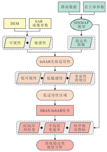
针对InSAR技术在短时强降雨诱发滑坡前兆识别中的不足,以四川理县西山村滑坡和黄泥坝子滑坡为研究对象,提出了一种耦合InSAR形变监测与SINMAP稳定性指数的降雨型突发滑坡早期识别方法.首先基于长期地表形变监测数据,通过可视性和测量敏感性分析定量评价InSAR的先验适用性;在低适用性区域,联合解析InSAR形变时序与稳定性指数时空演化特征,并构建时空交叉验证规则实现两类指标的有效融合与隐患综合判识.结果表明:西山村滑坡整体基本稳定,但降雨条件下前缘易发生局部失稳;黄泥坝子滑坡降雨敏感性强,但受几何畸变影响,InSAR难以捕捉其前兆变形.进一步利用该方法对2019年贵州鸡场镇降雨型突发滑坡进行重演验证,结果显示形变-稳定性指数耦合分析可有效识别InSAR单独监测难以发现的前兆信号,显著提升了降雨诱发突发滑坡的早期识别能力,为复杂地形区滑坡早期预警提供了新技术路径.
Abstract:Rainfall-induced rapid landslides triggered by short-duration heavy precipitation often exhibit undetectable precursory deformation in InSAR time series due to geometric distortions and limited temporal sampling. To address this limitation, this study develops an early identification framework that couples InSAR surface deformation monitoring with the physically based SINMAP stability index. Using long-term monitoring data from the Xishancun and Huangnibazi landslides (Lixian County, Sichuan Province), InSAR applicability was first quantitatively evaluated via visibility and measurement sensitivity analyses. In areas of poor InSAR performance, a spatiotemporal cross-validation strategy was established to integrate deformation trends with evolving stability index patterns for comprehensive hazard assessment. Results reveal that the Xishancun landslide is generally stable with only localized frontal instability under rainfall, whereas the Huangnibazi landslide is highly rainfall-sensitive yet challenging to monitor using InSAR alone due to layover and shadow effects. The approach was successfully validated on the 2019 Jichang rainfall-induced rapid landslide (Guizhou Province), effectively capturing pre-failure signals missed by InSAR. This coupled deformation–stability index method significantly enhances early detection of rainfall-triggered rapid landslides and offers a transferable technique for early warning in complex mountainous regions.
-
Key words:
- rainfall-triggered landslide /
- InSAR /
- stability index /
- prior applicability /
- early detection /
- engineering geology
-
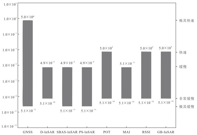
图 1 常用InSAR技术可监测变形速率范围(单位:m/s)
Fig. 1. Deformation rate range monitored by the common InSAR techniques
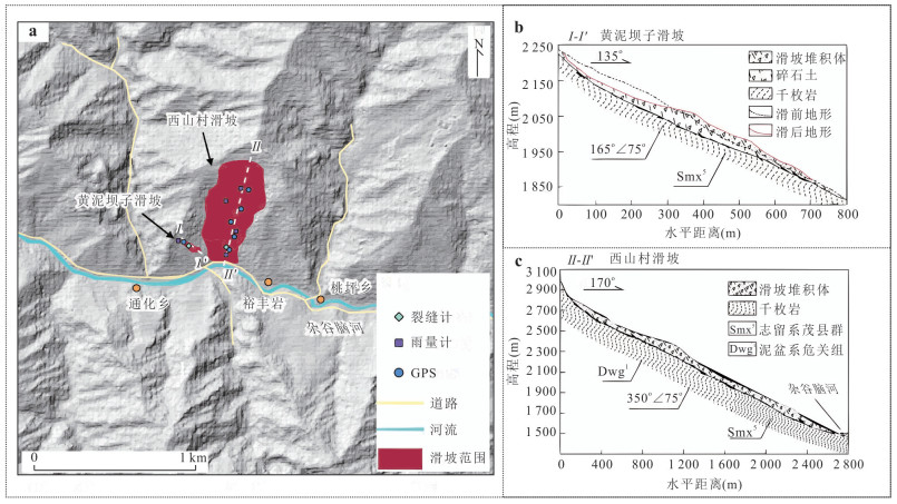
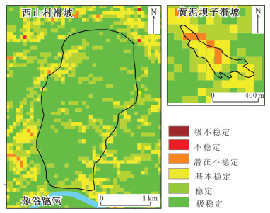
图 2 研究区概况
a.滑坡平面位置示意图;b.黄泥坝子滑坡工程地质剖面图;c.西山村滑坡工程地质剖面图
Fig. 2. Overview of the study area
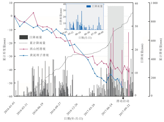
图 3 前期InSAR监测累积形变量与日降雨量
Fig. 3. Cumulative shape variables and daily rainfall from InSAR monitoring in the early stage
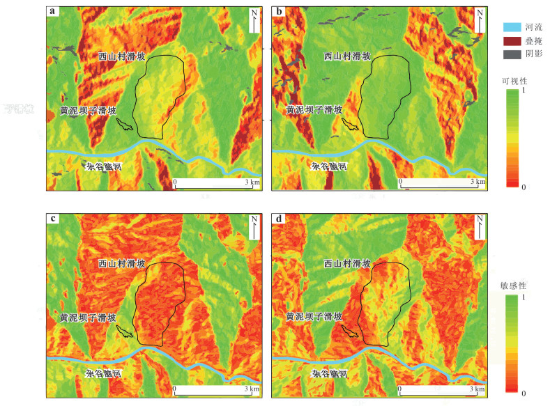
图 6 InSAR技术可视性与敏感性分析
a.升轨数据可视性;b.降轨数据可视性;c.升轨数据敏感性;d.降轨数据敏感性
Fig. 6. Visibility and sensitivity analysis for InSAR techniques
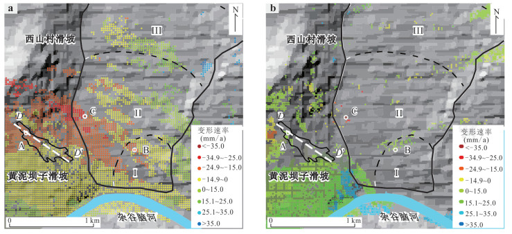
图 8 西山村滑坡、黄泥坝子滑坡雷达视向形变速率
a.升轨;b.降轨
Fig. 8. Radar deformation rate of Xishancun landslide and Huangnibazi landslide in apparent direction
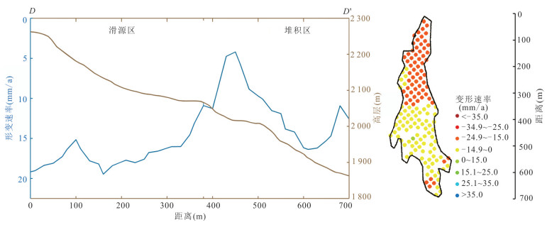
图 9 黄泥坝子滑坡D-D'剖面InSAR形变速率
Fig. 9. InSAR deformation rate diagram of D-D 'section of Huangnibazi landslide
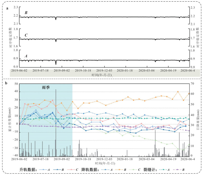
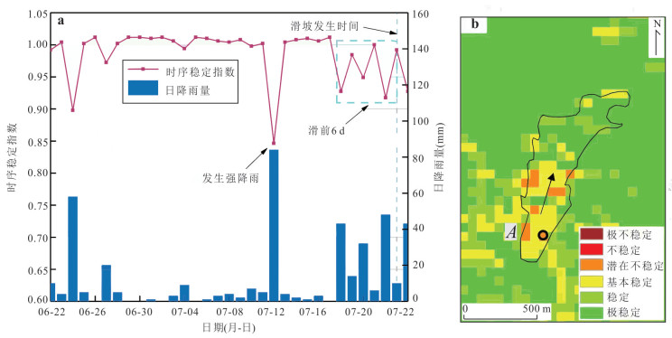
图 10 西山村滑坡、黄泥坝子滑坡
a.时序稳定指数;b.时序累积形变
Fig. 10. Xishancun landslide and Huangnibazi landslide
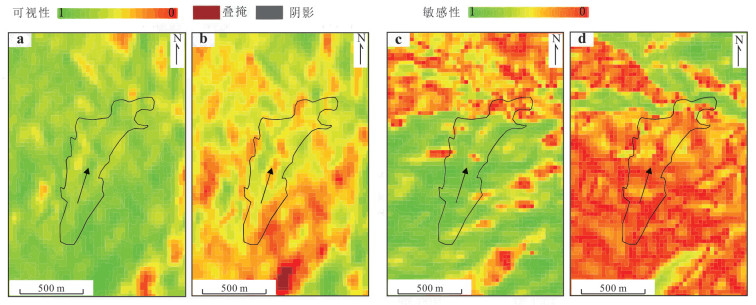
图 11 鸡场镇滑坡InSAR先验适用性分析结果
a.升轨可视性;b.降轨可视性;c.升轨敏感性;d.降轨敏感性
Fig. 11. InSAR prior applicability diagram of Jichang landslide
表 1 常用InSAR技术对比分析(李晓恩等,2021)
Table 1. Comparison of the common InSAR techniques
InSAR技术 优点 缺点 D-InSAR 覆盖范围广、数据量少、监测精度达厘米至分米级 易受时空失相干、大气效应制约对时空基线有一定要求,不适用于缓慢变形监测结果受DEM影响、无法得到时序数据 SBAS-InSAR 无需考虑时空基线、主影像选择问题、运算效率较高、监测精度可达毫米级别、可提取非线性形变 高相干点选取较难、应用推广存在一定的局限性、复杂形变环境易损失细节信息 PS-InSAR 对DEM、时空基线要求不高、适合监测城区、监测精度达毫米、亚毫米级别 形变解算精度依赖于PS点的空间密度、不适合大范围监测应用 POT 适合监测快速、大量级形变等滑坡、无面相位解缠处理、不受高相干性限制 形变监测精度受影像空间分辨率影响对大气相位的变化和低相干性不敏感 MAI 无需进行地形相位消除、相位解缠、能抑制大气相位延迟、可用于三维形变提取 MAI干涉图易受电离层影响、对干涉相位噪声提取敏感、低相干区适用性任、测量精度受限(依赖)于相干性、精度不高 RSSI 可测量大梯度形变,相对POT对地表特征依赖性小 对像素信号的杂波比敏感性高、对地表形变敏感性弱、小梯度形变区监测精度低 GB-InSAR 较低时间去相关,高时间分辨率、监测精度高、受外界影响小,采样周期短 只适用于单体已知滑坡、植被茂密区失相干严重、仅能观测视线向形变  下载: 导出CSV
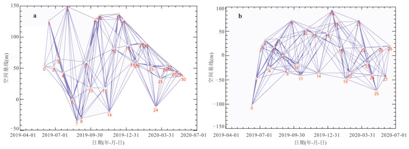
表 3 研究区Sentinel-1数据基本参数
Table 3. Basic parameters of Sentinel-1 data in the study area
参数 Sentinel-1A 轨道方向 升轨 降轨 空间分辨率(m) 5×20 5×20 航向角(°) -12.7 192.7 视线入射角(°) 39.44 41.86 影像数量 31 29 影像时间 2019-06-21~2020-05-27 2019-06-09~2020-06-15
下载: 导出CSV
表 4 稳定状况分级表
Table 4. Stability classification
稳定状况分级 稳定指数 稳定状况划分 稳定状态对应概率 稳定滑坡区域 SI > 1.5 极稳定 无条件稳定 1.5 > SI > 1.25 稳定 无条件稳定 1.25 > SI > 1.0 基本稳定 无条件稳定 非显性滑坡区域 1.0 > SI > 0.5 潜在不稳定 不稳定概率小于50% 0.5 > SI > 0 不稳定 不稳定概率大于50% 0 极不稳定 无条件不稳定
下载: 导出CSV
表 5 计算参数
Table 5. Calculation parameters
计算参数 土体密度
(kg/m3)渗透系数
(m/d)黏聚力(kPa) 内摩擦角(°) R/T 下限 上限 下限 上限 下限 上限 黄泥坝子滑坡 1 590 1.036 8 16 24 20 36 1/60 1/200 西山村滑坡 1 760 1.296 0 25 38 30 35
下载: 导出CSV
-
Berardino, P., Fornaro, G., Lanari, R., et al., 2002. A New Algorithm for Surface Deformation Monitoring Based on Small Baseline Differential SAR Interferograms. IEEE Transactions on Geoscience and Remote Sensing, 40(11): 2375-2383. https://doi.org/10.1109/TGRS.2002.803792 Cigna, F., Bateson, L. B., Jordan, C. J., et al., 2014. Simulating SAR Geometric Distortions and Predicting Persistent Scatterer Densities for ERS-1/2 and ENVISAT C-Band SAR and InSAR Applications: Nationwide Feasibility Assessment to Monitor the Landmass of Great Britain with SAR Imagery. Remote Sensing of Environment, 152: 441-466. https://doi.org/10.1016/j.rse.2014.06.025 Dai, K. R., Tie, Y. B., Xu, Q., et al., 2020. Early Identification of Potential Landslide Geohazards in Alpine-Canyon Terrain Based on SAR Interferometry—A Case Study of the Middle Section of Yalong River. Journal of Radars, 9(3): 554-568 (in Chinese with English abstract). Duan, C. S., 2019. Strength Characteristics of Slip Soil and Stability of Huangnibazi Landslide in Li County, Sichuan (Dissertation). Chengdu University of Technology, Chengdu (in Chinese with English abstract). Feng, W. K., Dun, J. W., Yi, X. Y., et al., 2020. Deformation Analysis of Woda Village Old Landslide in Jinsha River Basin Using SBAS-InSAR Technology. Journal of Engineering Geology, 28(2): 384-393 (in Chinese with English abstract). Guo, R., Li, S., Chen, Y., et al., 2021. Identification and Monitoring Landslides in Longitudinal Range-Gorge Region with InSAR Fusion Integrated Visibility Analysis. Landslides, 18(2): 551-568. doi: 10.1007/s10346-020-01475-7 He, C. Y., Ju, N. P., Xie, M. L., 2019. Application of InSAR Technology in Early Recognition of Geohazards. Journal of Xihua University (Natural Science Edition), 38(1): 32-39 (in Chinese with English abstract). He, J. Y., Ju, N. P., Xie, M. L., et al., 2023. Comparison of InSAR Technology for Identification of Hidden Dangers of Geological Hazards in Alpine and Canyon Areas. Earth Science, 48(11): 4295-4310 (in Chinese with English abstract). Li, X. E., Zhou, L., Su, F. Z., et al., 2021. Application of InSAR Technology in Landslide Hazard: Progress and Prospects. National Remote Sensing Bulletin, 25(2): 614-629 (in Chinese with English abstract). doi: 10.11834/jrs.20209297 Li, Z. H., Song, C., Yu, C., et al., 2019. Application of Satellite Radar Remote Sensing to Landslide Detection and Monitoring: Challenges and Solutions. Geomatics and Information Science of Wuhan University, 44(7): 967-979 (in Chinese with English abstract). Liao, M. S., Dong, J., Li, M. H., et al., 2021. Radar Remote Sensing for Potential Landslides Detection and Deformation Monitoring. National Remote Sensing Bulletin, 25(1): 332-341 (in Chinese with English abstract). doi: 10.11834/jrs.20210162 Lin, Q., 2016. Research on Structure Analysis and Stability Evaluation of Xishan Landslide in Li County, Sichuan (Dissertation). Chengdu University of Technology, Chengdu (in Chinese with English abstract). Lin, W., Yin, K. L., Wang, N. T., et al., 2021. Landslide Hazard Assessment of Rainfall-Induced Landslide Based on the CF-SINMAP Model: A Case Study from Wuling Mountain in Hunan Province, China. Natural Hazards, 106(1): 679-700. https://doi.org/10.1007/s11069-020-04483-x Liu, B., Hu, X. W., He, K., et al., 2022. Preliminary Analyses of the Tiejiangwan Landslide Occurred on April 5, 2021 in Hongya County, Sichuan Province, China. Landslides, 19(8): 2047-2051. https://doi.org/10.1007/s10346-021-01763-w Liu, P. Y., He, S. S., Wang, P. S., et al., 2022. Early Identification of Landslide Hazards in Southwest Mountainous Area Using Ascending and Descending Sentinel-1A and SBAS InSAR. Journal of Geodesy and Geodynamics, 42(9): 892-897 (in Chinese with English abstract). Luo, H. Y., Xu, Q., Jiang, Y. N., et al., 2024. The Prediction Method of Large-Scale Land Subsidence Based on Multi-Temporal InSAR and Machine Learning. Earth Science, 49(5): 1736-1745(in Chinese with English abstract). Notti, D., Herrera, G., Bianchini, S., et al., 2014. A Methodology for Improving Landslide PSI Data Analysis. International Journal of Remote Sensing, 35(6): 2186-2214. https://doi.org/10.1080/01431161.2014.889864 Pack, R. T., Tarboton, D. G., Goodwin, C. N., 1998. The SINMAP Approach to Terrain Stability Mapping. Congress of the International Association of Engineering Geology. https://api.semanticscholar.org/CorpusID:17978986 Rabonza, M. L., Felix, R. P., Lagmay, A. M. F. A., et al., 2016. Shallow Landslide Susceptibility Mapping Using High-Resolution Topography for Areas Devastated by Super Typhoon Haiyan. Landslides, 13(1): 201-210. https://doi.org/10.1007/s10346-015-0626-x Shi, G. L., Xu, L., Zhang, X. Y., et al., 2021. Monitoring Time Series Deformation of Xishancun Landslide with SBAS-InSAR. Science of Surveying and Mapping, 46(2): 93-98, 105 (in Chinese with English abstract). Teshebaeva, K., Roessner, S., Echtler, H., et al., 2015. ALOS/PALSAR InSAR Time-Series Analysis for Detecting Very Slow-Moving Landslides in Southern Kyrgyzstan. Remote Sensing, 7(7): 8973-8994. https://doi.org/10.3390/rs70708973 Wang, D. P., Li, Y. Z., Wang, Z. W., et al., 2022. Threat from Above! Assessing the Risk from the Tonghua High-Locality Landslide in Sichuan, China. Landslides, 19(3): 731-746. https://doi.org/10.1007/s10346-021-01836-w Wang, Y. A., Liu, D. L., Dong, J., et al., 2021. On the Applicability of Satellite SAR Interferometry to Landslide Hazards Detection in Hilly Areas: A Case Study of Shuicheng, Guizhou in Southwest China. Landslides, 18(7): 2609-2619. https://doi.org/10.1007/s10346-021-01648-y Wu, H., Pei, X. J., Cui, S. H., et al., 2021. Study of Topographic and Geological Controls on Landslide Development and Distribution within Mountainous Regions Influenced by Strong Earthquakes. Chinese Journal of Rock Mechanics and Engineering, 40(5): 972-986 (in Chinese with English abstract). Xie, M. L., Zhao, J. J., Ju, N. P., et al., 2020. Research on Temporal and Spatial Evolution of Landslide Based on Multisource Data: A Case Study of Huangnibazi Landslide. Geomatics and Information Science of Wuhan University, 45(6): 923-932 (in Chinese with English abstract). Xu, Q., 2020. Understanding the Landslide Monitoring and Early Warning: Consideration to Practical Issues. Journal of Engineering Geology, 28(2): 360-374 (in Chinese with English abstract). Yan, Y. Q., Guo, C. B., Zhang, Y. N., et al., 2024. Development and Deformation Characteristics of Large Ancient Landslides in the Intensely Hazardous Xiongba-Sela Section of the Jinsha River, Eastern Tibetan Plateau, China. Journal of Earth Science, 35(3): 980-997. https://doi.org/10.1007/s12583-023-1925-y Yan, Y. Q., Guo, C. B., Zhang, Y. S., et al., 2021. Study of the Deformation Characteristics of the Xiongba Ancient Landslide Based on SBAS-InSAR Method, Tibet, China. Acta Geologica Sinica, 95(11): 3556-3570 (in Chinese with English abstract). Zhao, W. H., Wang, R., Liu, X. W., et al., 2020. Field Survey of a Catastrophic High-Speed Long-Runout Landslide in Jichang Town, Shuicheng County, Guizhou, China, on July 23, 2019. Landslides, 17(6): 1415-1427. https://doi.org/10.1007/s10346-020-01380-z Zheng, G., Xu, Q., Liu, X. W., et al., 2020. The Jichang Landslide on July 23, 2019 in Shuicheng, Guizhou: Characteristics and Failure Mechanism. Journal of Engineering Geology, 28(3): 541-556 (in Chinese with English abstract). Zhuo, G. C., 2021. InSAR Early Identification of Landslide Hazards in Typical Sections of Sichuan-Tibet Railway and SAR Geometric Distortion Analysis (Dissertation). Chengdu University of Technology, Chengdu (in Chinese with English abstract). 戴可人, 铁永波, 许强, 等, 2020. 高山峡谷区滑坡灾害隐患InSAR早期识别: 以雅砻江中段为例. 雷达学报, 9(3): 554-568. 段诚仕, 2019. 理县黄泥坝子滑坡滑带土强度特性及稳定性分析(硕士学位论文). 成都: 成都理工大学. 冯文凯, 顿佳伟, 易小宇, 等, 2020. 基于SBAS-InSAR技术的金沙江流域沃达村巨型老滑坡形变分析. 工程地质学报, 28(2): 384-393. 何朝阳, 巨能攀, 解明礼, 2019. InSAR技术在地质灾害早期识别中的应用. 西华大学学报(自然科学版), 38(1): 32-39. 何佳阳, 巨能攀, 解明礼, 等, 2023. 高山峡谷地区地质灾害隐患InSAR识别技术对比. 地球科学, 48(11): 4295-4310. doi: 10.3799/dqkx.2022.308 李晓恩, 周亮, 苏奋振, 等, 2021. InSAR技术在滑坡灾害中的应用研究进展. 遥感学报, 25(2): 614-629. 李振洪, 宋闯, 余琛, 等, 2019. 卫星雷达遥感在滑坡灾害探测和监测中的应用: 挑战与对策. 武汉大学学报(信息科学版), 44(7): 967-979. 廖明生, 董杰, 李梦华, 等, 2021. 雷达遥感滑坡隐患识别与形变监测. 遥感学报, 25(1): 332-341. 林强, 2016. 理县西山村滑坡结构分析及稳定性评价(硕士学位论文). 成都: 成都理工大学. 刘排英, 贺少帅, 王鹏生, 等, 2022. 基于升降轨Sentinel-1A SBAS InSAR的西南山区滑坡隐患早期识别研究. 大地测量与地球动力学, 42(9): 892-897. 罗袆沅, 许强, 蒋亚楠, 等, 2024. 基于时序InSAR与机器学习的大范围地面沉降预测方法. 地球科学, 49(5): 1736-1745. doi: 10.3799/dqkx.2023.048 石固林, 徐浪, 张璇钰, 等, 2021. 西山村滑坡时序形变的SBAS-InSAR监测. 测绘科学, 46(2): 93-98, 105. 吴昊, 裴向军, 崔圣华, 等, 2021. 强震山区滑坡发育分布的地形地质控制作用研究. 岩石力学与工程学报, 40(5): 972-986. 解明礼, 赵建军, 巨能攀, 等, 2020. 多源数据滑坡时空演化规律研究: 以黄泥坝子滑坡为例. 武汉大学学报(信息科学版), 45(6): 923-932. 许强, 2020. 对滑坡监测预警相关问题的认识与思考. 工程地质学报, 28(2): 360-374. 闫怡秋, 郭长宝, 张永双, 等, 2021. 基于SBAS-InSAR技术的西藏雄巴古滑坡变形特征. 地质学报, 95(11): 3556-3570. 郑光, 许强, 刘秀伟, 等, 2020.2019年7月23日贵州水城县鸡场镇滑坡-碎屑流特征与成因机理研究. 工程地质学报, 28(3): 541-556. 卓冠晨, 2021. 川藏铁路典型工段滑坡灾害隐患InSAR早期识别与SAR几何畸变分析(硕士学位论文). 成都: 成都理工大学. -

 点击查看大图
计量
- 文章访问数: 270
- HTML全文浏览量: 15
- PDF下载量: 46
- 被引次数: 0
