




3D Perception and Reconstruction of Underground Coal Mine Roadways Based on Multi-Sensor Fusion
-
摘要: 煤矿作为重要的能源资源,其井下环境普遍存在结构复杂、空间狭窄、光照不足及防爆需求高等特点,这对精细化三维感知与建模提出了严峻挑战. 高精度三维重建不仅是保障矿山作业安全的关键环节,也是开展地层结构解析、透明地质体系构建和动态环境监测的重要基础. 针对传统单一传感器在井下场景中受遮挡严重、噪声干扰大、建模精度有限的问题,本文提出了一种基于多传感器融合的三维建模方法. 该方法在巷道清洗车上部署多线激光雷达阵列,并融合视觉与毫米波雷达信息,通过结合局部特征描述与参数估计(LEPE-ICP)的自动拼接策略,提取多源数据中的稳定几何与纹理特征,采用基于特征匹配的初始配准与基于概率分布优化的精细配准相结合的两阶段融合方法,有效克服井下环境中由重复结构、动态干扰和光照变化引起的匹配歧义,逐步构建井下巷道的全局三维模型. 实验结果表明,该方法在煤矿巷道环境中的平均平移误差小于0.12 m,相较于传统方法拼接效率提升约47%,同时目标识别准确率达到92.7%. 研究结果证明,多源信息融合能够显著提升煤矿井下三维建模的精度与鲁棒性,为地层结构智能建模、透明地质构建及煤矿智能化发展提供了可靠的数据支撑与技术参考.Abstract: As a crucial energy resource, coal mines are characterized by complex structures, confined spaces, and insufficient illumination in their underground environments, posing significant challenges to fine-grained 3D perception and modeling. High-precision 3D reconstruction is not only a key factor in ensuring mining operation safety but also serves as an essential foundation for analyzing stratigraphic structures, constructing transparent geological systems, and monitoring dynamic environments. To address the limitations of traditional single-sensor approaches in underground scenarios, such as severe occlusion, high noise interference, and limited modeling accuracy: this paper proposes a multi-sensor fusion-based 3D modeling method. The approach involves deploying a multi-line LiDAR array on a roadway cleaning vehicle and integrating visual and millimeter-wave radar data. By employing an automatic stitching strategy that combines local feature description and parameter estimation, stable geometric and texture features from multi-source data are extracted. A two-stage fusion method is adopted, which integrates initial registration based on feature matching and fine registration optimized via probability distribution, effectively overcoming matching ambiguities caused by repetitive structures, dynamic interference, and varying lighting conditions in underground environments. This process progressively constructs a global 3D model of the underground roadway. Experimental results demonstrate that the proposed method achieves an average registration error of less than 0.12 m in coal mine roadway environments, improves stitching efficiency by approximately 47% compared to conventional methods, and reaches a target recognition accuracy of 92.7%. The findings confirm that multi-source information fusion significantly enhances the accuracy and robustness of 3D modeling in underground coal mines, providing reliable data support and technical reference for intelligent stratigraphic modeling, transparent geological construction, and the advancement of smart mining.
-
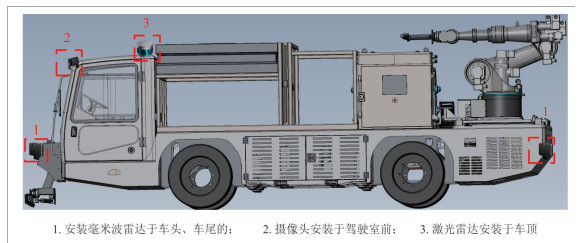
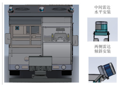
图 1 巷道清洗车传感器系统部署图
Fig. 1. Layout diagram of sensor system for roadway cleaning vehicle
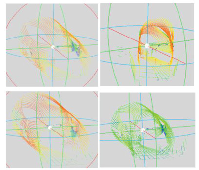
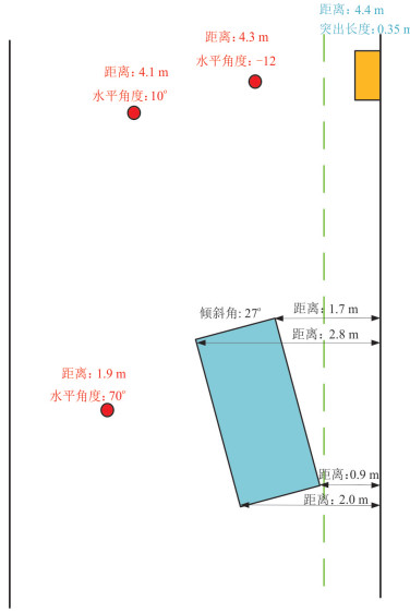
图 10 不同倾斜角度点云拼接效果
Fig. 10. Point cloud splicing effect at different inclination angles
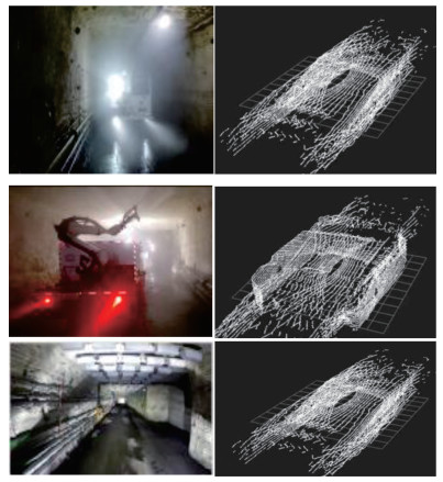
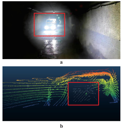
图 11 不同光照强度的点云拼接效果
Fig. 11. Point cloud splicing effect under different light intensities
表 1 多目标场景下距离估计结果
Table 1. Distance estimation results in multi-target scenarios
目标类别 场景描述 系统估计距离(m) 实测距离(m) 行人1 巷道中部,光照良好 10.25 10.12 行人2 巷道侧壁,有阴影 7.68 7.80 车辆 近场 3.41 3.50  下载: 导出CSV
表 2 对比实验结果
Table 2. Comparative experimental results
性能指标 LEPE-ICP ICP算法 NDT算法 E1(°) 0.076 0.112 0.095 E2(m) 0.12 0.18 0.16 耗时(s) 0.22 0.36 0.31
下载: 导出CSV
-
Baek, J., Park, J., Cho, S., et al., 2022. 3D Global Localization in the Underground Mine Environment Using Mobile LiDAR Mapping and Point Cloud Registration. Sensors, 22(8): 2873. https://doi.org/10.3390/s22082873 Bai, Y. H., Zhang, B. H., Xu, N. M., et al., 2023. Vision-Based Navigation and Guidance for Agricultural Autonomous Vehicles and Robots: A Review. Computers and Electronics in Agriculture, 205(6): 107584. https://doi.org/10.1016/j.compag.2022.107584 Gao, Y. J., Tan Z., Ma L., et al., 2020. Research Status and Application of Unmanned Driving Technology for Underground Rubber-Tyred Vehicles without Tracks. China Coal, 51(6): 93-103 (in Chinese with English abstract). Geng, X., Wang, Z. B., Jin, Y., et al., 2020. Three-Dimensional Human Body Reconstruction Based on a Single Depth Camera. Foreign Electronic Measurement Technology, 39(9): 143-146. (in Chinese with English abstract). Gong, Y. M., Xiao, D. Y., Wang, J. J., 2001. Application of Multi-Sensor Data Fusion Technology in Self-Controlled Vertical Drilling Detection System. Earth Science, (5): 524-528. (in Chinese with English abstract). Huang, C. Q., Jiang, F., Huang, Q. H., et al., 2024. Dual-Graph Attention Convolution Network for 3-D Point Cloud Classification. IEEE Transactions on Neural Networks and Learning Systems, 35(4): 4813-4825. https://doi.org/10.1109/tnnls.2022.3162301 Jia, J. W., Lu, Q. H., Li, H. S., et al., 2024. Research on the Application of Multi-LiDAR in Three-Dimensional Reconstruction System of Coal Mine Roadways. China Coal, 50(10): 84-90 (in Chinese with English abstract). Jiao, Y. Y., 2022. How can the New Generation of Information Technology Support the Construction of Transparent Urban Geology? Earth Science, 47(10): 3918 (in Chinese with English abstract). Li, J. M., Chen, X., 2020. Image Texture Feature Extraction Method Based on Local Adaptive Light and Dark Mode. Laser Journal, 46(7): 101-110(in Chinese with English abstract). Liang, Q. J., Yang, L., Luo, Z., et al., 2023. A Siamese Network-Based Method for Automatic Stitching of Artifact Fragments. IEEE Transactions on Instrumentation and Measurement, 72: 1-13. https://doi.org/10.1109/tim.2023.3295018 Lin, J. R., Zheng, C. R., Xu, W., et al., 2021. R $^2$ LIVE: A Robust, Real-Time, LiDAR-Inertial-Visual Tightly-Coupled State Estimator and Mapping. IEEE Robotics and Automation Letters, 6(4): 7469-7476. https://doi.org/10.1109/lra.2021.3095515 Liu, S. G., Xie, Z., Han, Y. M., et al., 2019. Point Cloud Denoising Based on Improved Statistical Filtering Algorithm and Moving Least Squares Method. Acta Optica Sinica, 39(9): 0915002(in Chinese with English abstract). doi: 10.3788/AOS201939.0915002 Long, L. J., Xia, Y. H., Huang, D., 2020. Fast Modeling Method for Substation Based on 3D Laser Scanning Point Cloud Data. Laser & Optoelectronics Progress, 57(20): 202801. https://doi.org/10.3788/lop57.202801 Ma, H. C., 2011. Several Applications of Lidar Measurement Technology in Geoscience. Earth Science, 36(2): 347-354 (in Chinese with English abstract). Maccarone, A., Drummond, K., Anderson, B., et al., 2023. Submerged Single-Photon LiDAR Imaging Sensor Used for Real-Time 3D Scene Reconstruction in Scattering Underwater Environments. Optics Express, 31(10): 16690. https://doi.org/10.1364/oe.487129 Mao, Q. H., Chai, J. Q., Chen, Y. Z., et al., 2020. A Three-Dimensional Reconstruction Method for Coal Mine Tunneling Roadways Based on the Fusion of LiDAR and IMU. Coal Science and Technology, 53(2): 351-362(in Chinese with English abstract). Mao, X. C., Duan, X. M., Deng, H., et al., 2026. Theory, Methods and Challenges of Three-Dimensional Intelligent Prediction of Deep Mineral Resources. Earth Science, 51(3): 793-815(in Chinese with English abstract). Othman, U., Yang, E. F., 2023. Human-Robot Collaborations in Smart Manufacturing Environments: Review and Outlook. Sensors, 23(12): 5663. https://doi.org/10.3390/s23125663 Rusu, R. B., Blodow, N., Beetz, M., 2009. Fast point Feature Histograms (FPFH) for 3D Registration. 2009 IEEE International Conference on Robotics and Automation. IEEE, 2009: 3212-3217. Tan, J. S., Zhu, W. G., Du, X. F., 2020. Three-Dimensional Reconstruction and Investigation Analysis of Geological Disaster Scenes Based on Unmanned Aerial Vehicle Oblique Photography. Engineering Investigation, 53(7): 72-78. (in Chinese with English abstract). Tian, M. H., Li, P., Yan, S., et al., 2025. 3D-RGB Point Cloud Imaging Based on Data Level Fusion of Two-Dimensional LiDAR and Multi-View Camera. Data Collection and Processing, 40(6): 1505-1517 (in Chinese with English abstract). Wang, G. F., 2022. Discussion on the Latest Technological Progress and Issues of Intelligent Coal Mines. Coal Science and Technology, 50(1): 1-27 (in Chinese with English abstract). Wang, G. F., Wang H., Ren, H. W. et al., 2018. The Scenario Goals and Development Paths of Smart Coal Mines in 2025. Journal of China Coal Society, 43(2): 295-305. Wang, S. Q., Li, J. Y., 2024. Miner Pose Detection Algorithm Based on Improved YOLOv7 in the Coal Mine. Journal of Physics: Conference Series, 2770(1): 012010. https://doi.org/10.1088/1742-6596/2770/1/012010 Wang, T. R., Ji, X. B., Wang, J. B., et al., 2025. Implicit 3D Geological Modeling Based on Machine Learning: A Case Study of the Lazigou Gold Mine in the Mulu Mineralization Belt. Earth Science, 50(8): 3167-3181 (in Chinese with English abstract). Wang, Y. S., Zheng, G. P., Wang, X., 2019. Development and Application of a Goaf-Safety Monitoring System Using Multi-Sensor Information Fusion. Tunnelling and Underground Space Technology, 94(3-4): 103112. https://doi.org/10.1016/j.tust.2019.103112 Yang, J. J., Wang, C., Luo, W. J., et al., 2021. Research on Point Cloud Registering Method of Tunneling Roadway Based on 3D NDT-ICP Algorithm. Sensors, 21(13): 4448. https://doi.org/10.3390/s21134448 Zhang, J. W., Ma, J., Jiang D., et al., 2025. Coal Mine Underground Personnel Detection Algorithm Based on Improved YOLOv7. Coal Mine Machinery, 46(8): 213-217. (in Chinese with English abstract). Zhong, Y., 2009. Intrinsic Shape Signatures: A Shape Descriptor for 3D Object Recognition. 2009 IEEE 12th International Conference on Computer Vision Workshops, ICCV Workshops. IEEE, 2009: 689-696. Zhou, Z. G., Cao. J. W., Di, S. F., 2021. A Review of 3D LiDAR SLAM Algorithms. Journal of Scientific Instrument, 42(9): 13-27. (in Chinese with English abstract). Zuo, X. X., et al., 2019. "Licfusion: Lidarinertial-Camera odometry. " 2019 IEEE/RSJ International Conference on Intelligent Robots and Systems (IROS). IEEE. 高永军, 谭震, 马亮, 等, 2025. 井下无轨胶轮车无人驾驶技术研究现状及应用. 中国煤炭, 51(6): 93-103. 耿璇, 王召巴, 金永, 等, 2020. 基于单个深度相机的人体三维重建. 国外电子测量技术, 39(9): 143-146. 龚元明, 萧德云, 王俊杰, 2001. 多传感器数据融合技术在自控垂钻检测系统中的应用. 地球科学, (5): 524-528. http://www.earth-science.net/article/id/1045 贾江伟, 路前海, 李洪胜, 等, 2024. 多激光雷达在煤矿巷道三维重构系统中的应用研究. 中国煤炭, 50(10): 84-90. 焦玉勇, 2022. 新一代信息科技如何支持城市透明地质建设?. 地球科学, 47(10): 3918. doi: 10.3799/dqkx.2022.864 李江美, 陈熙, 2025. 基于局部自适应明暗模式的图像纹理特征提取方法. 激光杂志, 46(7): 101-110. 刘尚国, 谢政, 韩友美, 等, 2019. 基于改进的统计滤波算法与移动最小二乘法的点云去噪. 光学学报, 39(9): 0915002. 马洪超. 激光雷达测量技术在地学中的若干应用, 2011. 地球科学, 36(2): 347-354. doi: 10.3799/dqkx.2011.037 毛清华, 柴建权, 陈彦璋, 等, 2025. 激光雷达和IMU融合的煤矿掘进巷道三维重建方法. 煤炭科学技术, 53(2): 351-362. 毛先成, 段新明, 邓浩, 等, 2026. 深部矿产三维智能预测理论、方法与挑战. 地球科学, 51(3): 793-815. doi: 10.3799/dqkx.2025.227 谭金石, 祖为国, 杜向锋, 2025. 基于无人机倾斜摄影的地质灾害场景三维重建及调查分析. 工程勘察, 53(7): 72-78. 田明昊, 李攀, 阎肃, 等, 2025. 基于二维激光雷达和多视角相机数据级融合的3D-RGB点云成像. 数据采集与处理, 40(6): 1505-1517. 王国法, 王虹, 任怀伟, 等, 2018. 智慧煤矿2025情景目标和发展路径. 煤炭学报, 43(2): 295-305. 王国法, 2022. 煤矿智能化最新技术进展与问题探讨. 煤炭科学技术, 50(1): 1-27. 王统荣, 纪旭波, 王江波, 等, 2025. 基于机器学习的隐式三维地质建模: 以牟乳成矿带腊子沟金矿为例. 地球科学, 50(8): 3167-3181. doi: 10.3799/dqkx.2025.048 张杰文, 马骥, 蒋栋, 等, 2025. 基于改进YOLOv7的煤矿井下人员检测算法. 煤矿机械, 46(8): 213-217. 周治国, 曹江微, 邸顺帆, 2021. 3D激光雷达SLAM算法综述. 仪器仪表学报, 42(9): 13-27. -


 点击查看大图
计量
- 文章访问数: 477
- HTML全文浏览量: 47
- PDF下载量: 69
- 被引次数: 0
