




UAV Thermal Infrared Geothermal Target Area Delineation for Shallow Geothermal Resources
-
摘要: 针对卫星热红外遥感在地热探测中存在空间分辨率低、易受太阳辐射影响等问题.研究依托DJI Mavic 3T无人机平台,获取研究区高分辨率真彩色与热红外影像.并基于DJI Thermal SDK建立自动化地表温度反演流程,得到无人机地表温度结果.通过现场温度实测数据验证,无人机温度结果与实测点位温度变化趋势具有良好一致性;将无人机热红外影像重采样至30 m后,与Landsat-8 TIRS温度反演结果在空间分布上有较强的一致性.基于提出的“十字型”与“一字型”地热靶区圈定模式,结合研究区构造格局与热异常分布规律,共识别出6处潜在地热靶区,并综合米地温实测数据与既有地质资料对其地热成因进行了分析.研究表明,无人机热红外技术能够在复杂山地环境中实现高精度地热异常识别,为小尺度地热靶区圈定、资源潜力评价提供重要技术支撑.未来需引入多深度米地温数据与浅层热扩散模型,以增强热异常与深部热源之间的定量联系.Abstract: In view of the low spatial resolution and strong susceptibility to solar radiation effects of satellite-based thermal infrared remote sensing in geothermal exploration, this study employs a DJI Mavic 3T unmanned aerial vehicle to acquire high-resolution true-color and thermal infrared imagery over the study area. An automated land surface temperature retrieval workflow was developed based on the DJI Thermal SDK to obtain UAV-derived surface temperature data. Validation using in situ temperature measurements demonstrates that the UAV-retrieved temperatures exhibit a high degree of consistency with the observed temperature variation trends at ground sampling points. After resampling the UAV thermal infrared imagery to 30 m, the retrieved temperatures show strong spatial agreement with those derived from Landsat-8 TIRS data. Based on the proposed "cross-shaped" and "linear" geothermal target delineation patterns, six potential geothermal targets were identified by integrating the regional structural framework with the spatial distribution characteristics of thermal anomalies. Furthermore, the geothermal genesis of the delineated targets was analyzed through the combined use of measured shallow ground temperature data and existing geological information. The results indicate that UAV-based thermal infrared technology enables high-precision identification of geothermal anomalies in complex mountainous terrains, providing effective technical support for small-scale geothermal target delineation and resource potential assessment. Future work should incorporate multi-depth ground temperature measurements and shallow heat diffusion models to strengthen the quantitative linkage between surface thermal anomalies and deep geothermal heat sources.
-
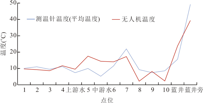
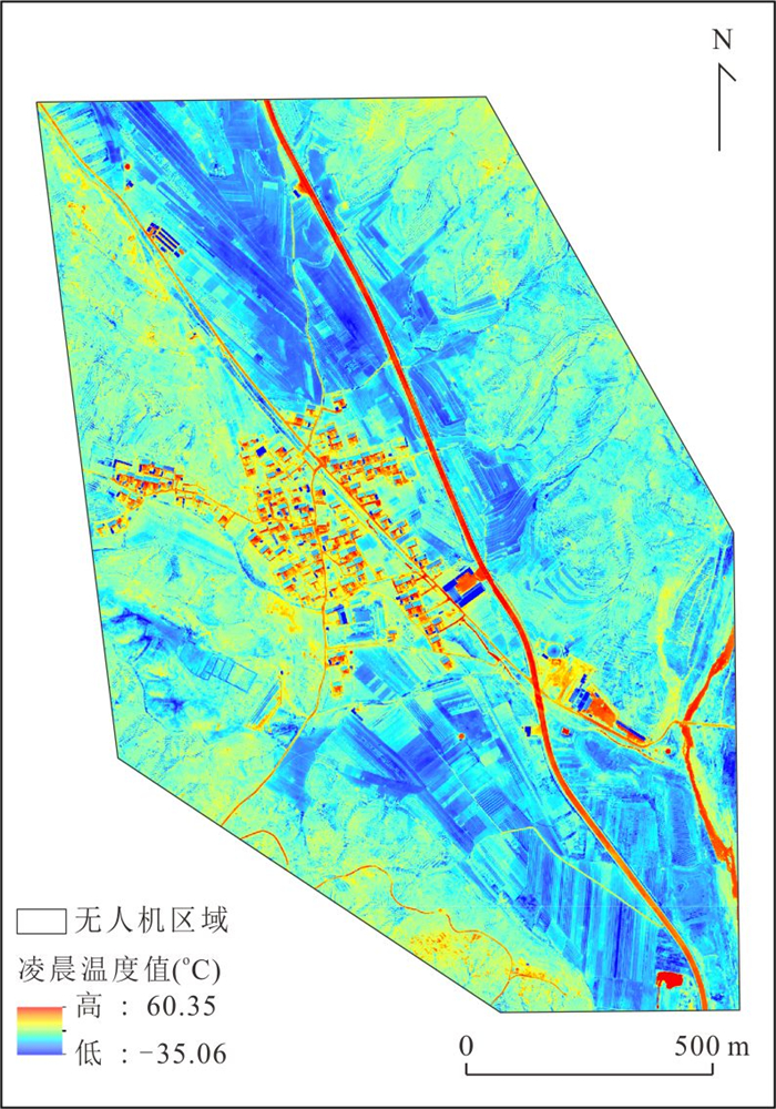
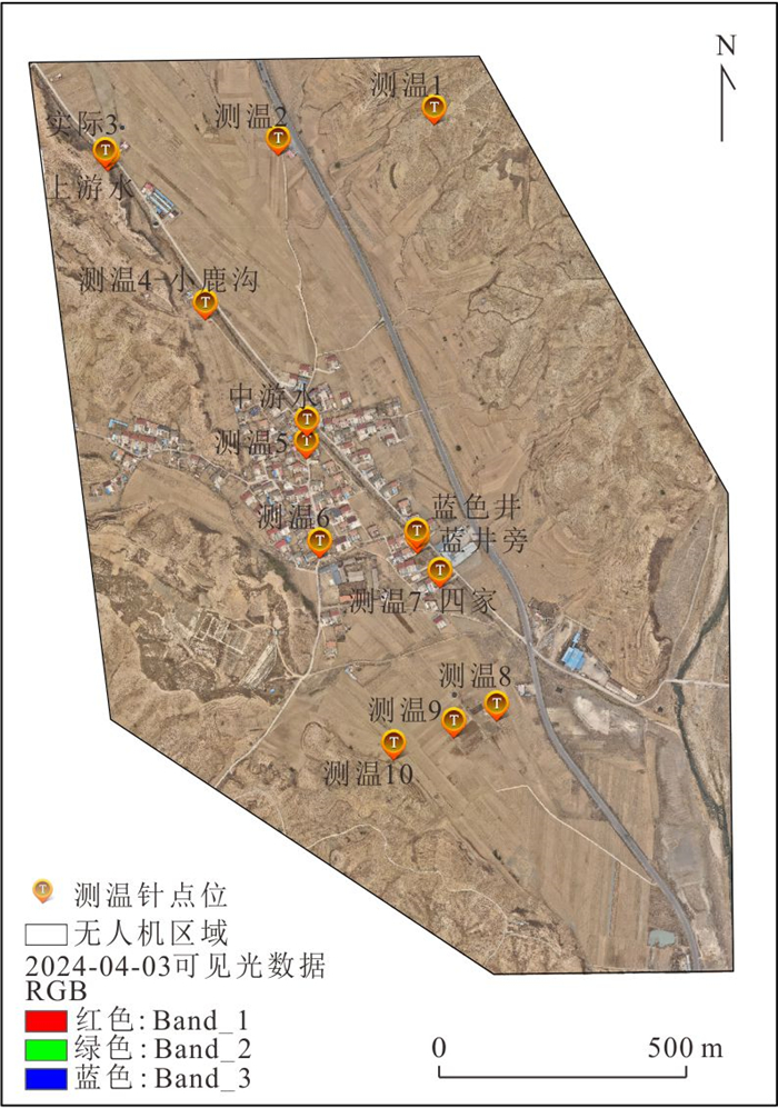
图 6 2024年4月3日凌晨实地测温与无人机温度对比
Fig. 6. Comparison of field temperatures and drone temperatures in the early morning of April 3, 2024
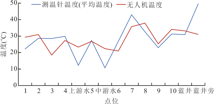
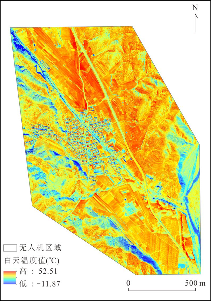
图 7 2024年4月3日白天实地测温与无人机温度对比
Fig. 7. Comparison between field-measured temperature and UAV-derived temperature during daytime on April 3, 2024
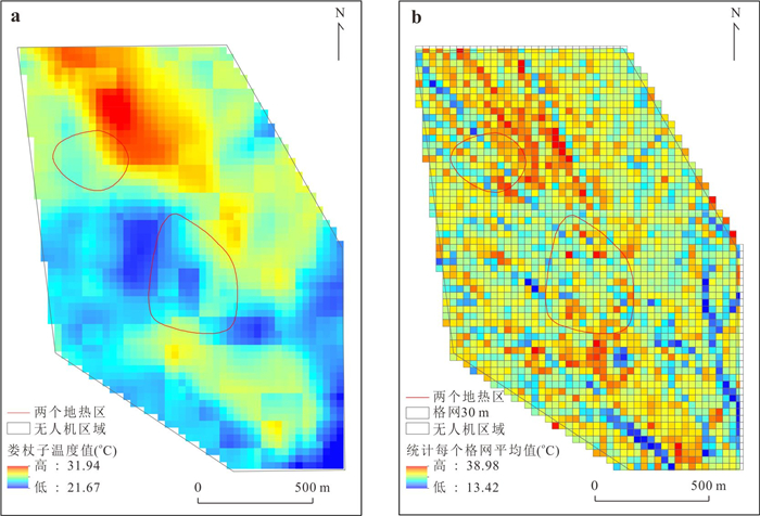
图 8 无人机地表温度与Landsat 8地表温度对比
a. 2024-04-01 Landsat 8地表温度结果; b. 2024-04-03无人机30 m取均值结果
Fig. 8. Comparison between UAV land surface temperature and Landsat 8 land surface temperature
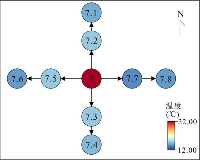
图 9 地体方面找地热靶区模式
Fig. 9. Model for locating geothermal target areas in terms of geology
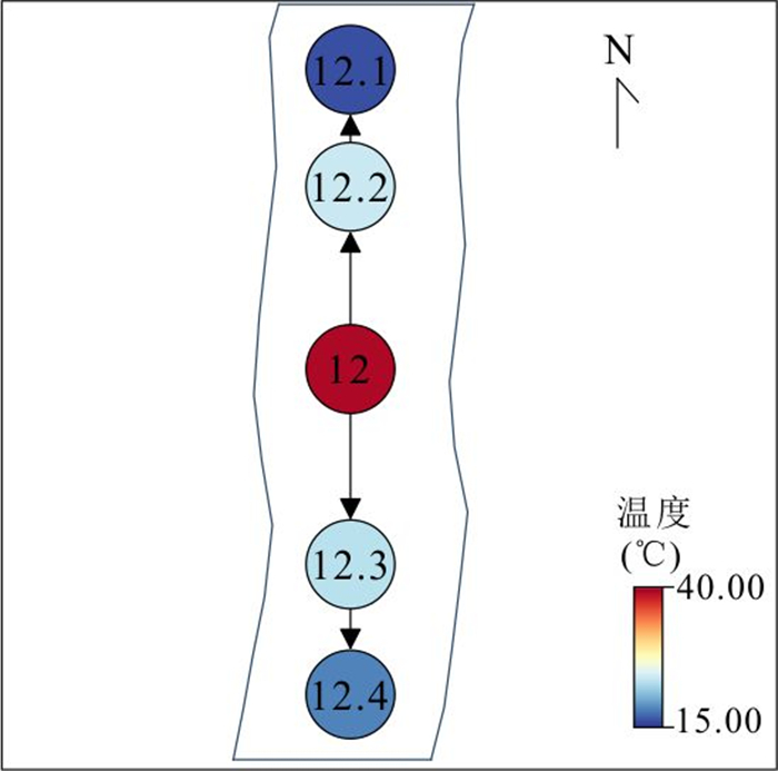
图 10 水体方面找地热靶区模式
Fig. 10. Model for locating geothermal target areas in terms of water bodies
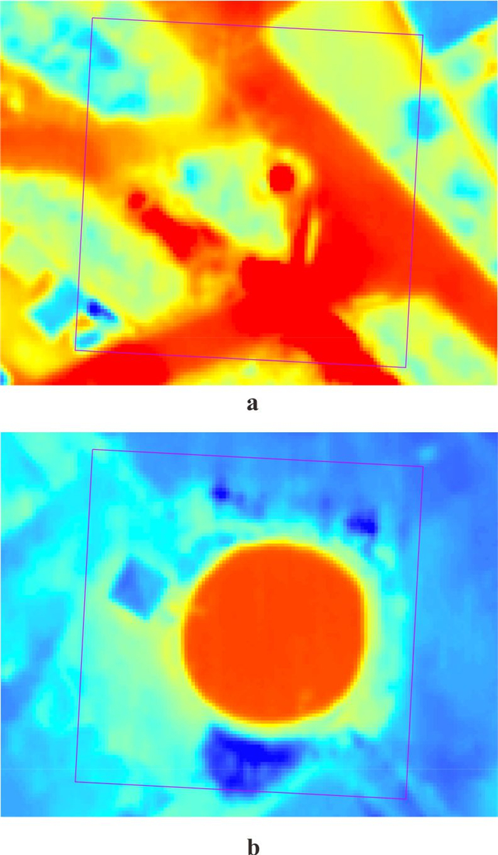
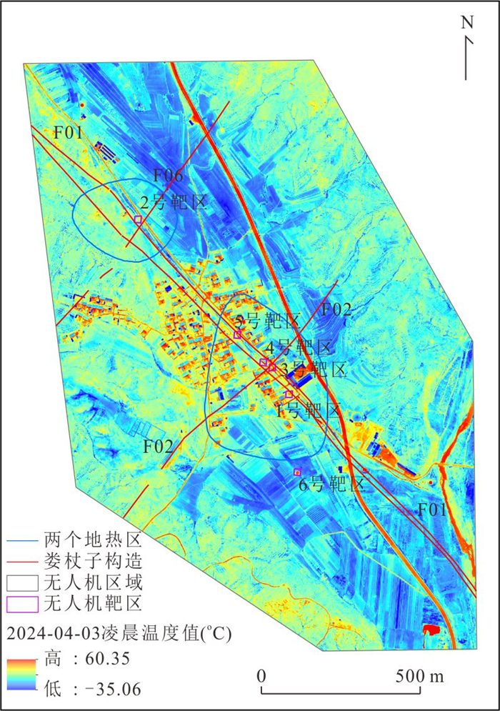
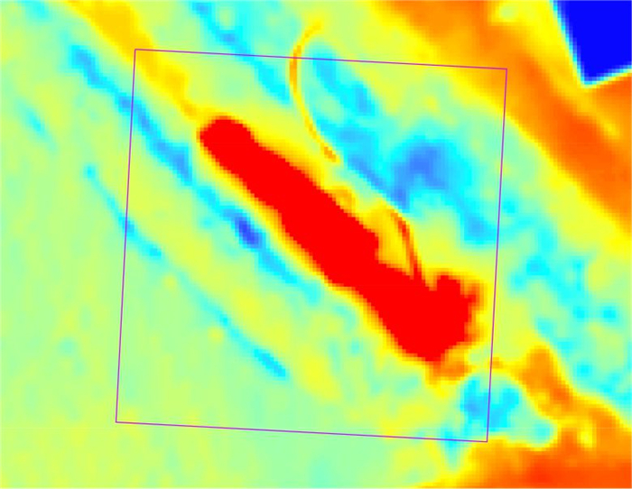
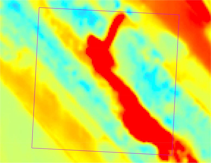
图 14 无人机局部3、6号靶区情况
a.3号靶区情况; b.6号靶区情况
Fig. 14. Local situation of target areas of UAV No. 3 and No. 6
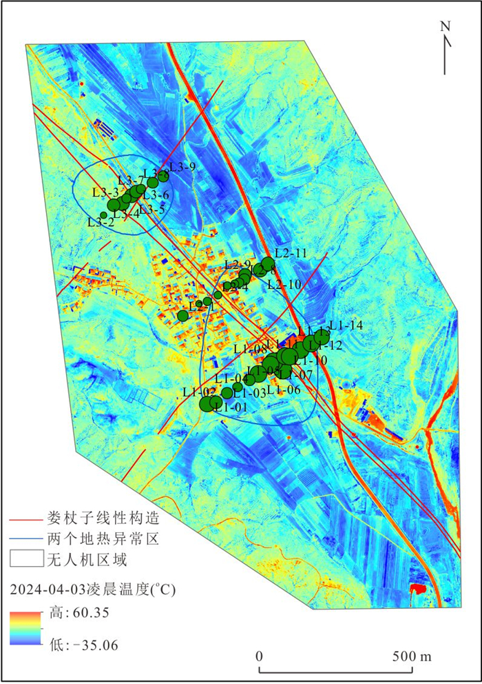
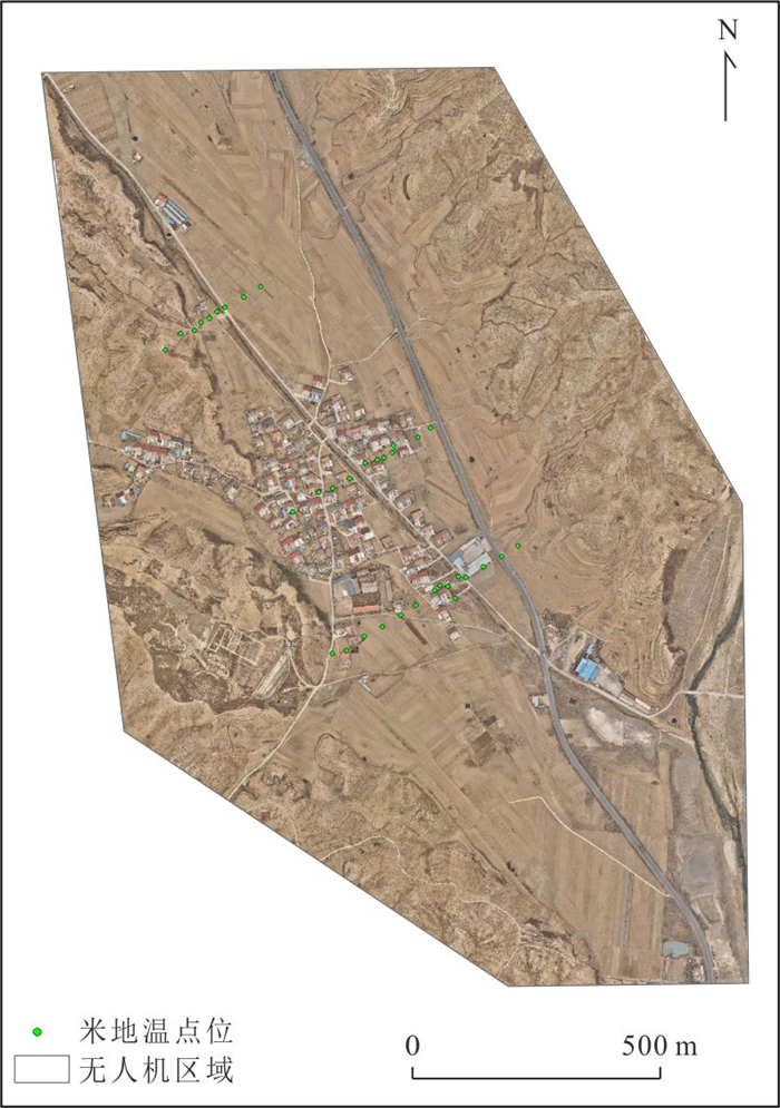
图 16 米地温总体与无人机温度空间对比
Fig. 16. Spatial comparison between overall 1-meter soil temperature and UAV temperature
表 1 2024年4月3日无人机飞行参数设置
Table 1. Drone flight parameter settings on April 3, 2024
飞行设置 起飞高度(m) 航线高度(m) 航向重叠度(%) 旁向重叠度(%) 参数 110 110 85 75  下载: 导出CSV
表 2 无人机热红外相机参数
Table 2. Parameters of the thermal and infrared camera on the drone
性能参数 具体参数值 无人机型号 DJI Mavic 3T 热成像传感器类型 非制冷氧化钒(VOx) 分辨率 640 × 512 镜头 DFOV:61°
等效焦距:40 mm
光圈:f/1.0
对焦距离:5 m至无穷远像素大小 12 μm 波长范围 8~14 μm 测温方式 点测温、区域测温 测温精度 ±2 ℃或±2%,取较大值 测温范围 -20 ℃至150 ℃(高增益模式)
0 ℃至500 ℃(低增益模式)照片拍摄模式 单张拍摄:640×512
定时拍摄:640×512
JPEG:2/3/5/7/10/15/20/30/60 s照片格式 JPEG(8位)
R⁃JPEG(16位)
下载: 导出CSV
表 3 2024年4月3日凌晨无人机热红外飞行参数设置
Table 3. UAV thermal infrared flight parameter settings for the early morning of April 3, 2024
飞行设置 起飞高度
(m)航线高度
(m)航向重叠度
(%)旁向重叠度
(%)参数 110 110 80 70
下载: 导出CSV
表 4 2024年4月3日白天无人机热红外飞行参数设置
Table 4. Daytime UAV thermal infrared flight parameter settings for April 3, 2024
飞行设置 起飞高度
(m)航线高度
(m)航向重叠度
(%)旁向重叠度
(%)参数 110 110 85 75
下载: 导出CSV
表 5 2024年4月3日凌晨实测温度与无人机温度对比
Table 5. Comparison between field-measured temperature and UAV-derived temperature on the early morning of April 3, 2024
点位 测温针温度(℃) 无人机温度(℃) 1 10.07 9.74 2 11.00 9.27 3 9.50 8.64 4 11.17 11.66 上游水 7.40 9.54 5 10.00 17.52 中游水 5.23 14.40 6 11.57 14.06 7 21.95 17.26 8 9.27 2.24 9 7.43 8.17 10 8.57 2.34 蓝井 15.60 23.77 蓝井旁 49.20 39.35
下载: 导出CSV
表 6 2024年4月3日白天实测温度与无人机温度对比
Table 6. Comparison between field-measured temperature and UAV-derived temperature during daytime on April 3, 2024
点位 测温针温度(℃) 无人机温度(℃) 1 22.13 29.26 2 28.60 30.94 3 28.50 18.47 4 29.83 27.30 上游水 12.27 23.32 5 27.33 26.84 中游水 10.73 22.37 6 26.77 20.91 7 42.94 35.70 8 32.63 37.85 9 22.97 25.31 10 31.23 34.05 蓝井 30.90 33.13 蓝井旁 49.63 31.00
下载: 导出CSV
表 7 以7号点为中心的“十”字测温
Table 7. "Cross" temperature measurement centered on Point 7
点位 凌晨夜间温度(℃) 7 21.95 7.1 13.0 7.2 13.5 7.3 13.5 7.4 13.2 7.5 13.5 7.6 12.8 7.7 12.6 7.8 12.8
下载: 导出CSV
表 8 以蓝井旁点为中心的“一”字无人机温度
Table 8. Drone temperature of the "one" shape centered on the point beside the blue well
点位 夜间温度(℃) 12.1 15.27 12.2 20.73 12 39.35 12.3 20.08 12.4 16.31
下载: 导出CSV
表 9 4号靶区的“一”字无人机温度
Table 9. Drone temperature of the "One" shape in target area No. 4
点位 凌晨温度(℃) 4号-1 5.13 4号-2 11.42 4号 27.01 4号-3 11.10 4号-4 7.14
下载: 导出CSV
表 10 5号靶区的“一”字无人机温度
Table 10. Temperature of the "One" shape drone in target area No. 5
点位 凌晨温度(℃) 5号-1 7.54 5号-2 10.26 5号 26.87 5号-3 12.97 5号-4 7.31
下载: 导出CSV
-
Avtar, R., Sahu, N., Aggarwal, A. K., et al., 2019. Exploring Renewable Energy Resources Using Remote Sensing and GIS: A Review. Resources, 8(3): 149. https://doi.org/10.3390/resources8030149 Chao, J. Q., Zhao, Z. F., Xu, S. G., et al., 2024. Geothermal Target Detection Integrating Multi-Source and Multi-Temporal Thermal Infrared Data. Ore Geology Reviews, 167: 105991. https://doi.org/10.1016/j.oregeorev.2024.105991 Ciriaco, A. E., Zarrouk, S. J., Zakeri, G., 2020. Geothermal Resource and Reserve Assessment Methodology: Overview, Analysis and Future Directions. Renewable and Sustainable Energy Reviews, 119: 109515. https://doi.org/10.1016/j.rser.2019.109515 Gao, Y. Y., 2022. Geothermal Exploration Based on Multi-Source Thermal Infrared Remote Sensing Technology (Dissertation). China University of Mining and Technology, Xuzhou (in Chinese with English abstract). Jiang, X. X., Zhu, C. Q., 2025. Different Distribution of Deep and Shallow Geothermal Resources in Jizhong Depression under Complex Heat Transfer. Earth Science, 50(4): 1485-1498(in Chinese with English abstract). Lei, Y. K., Wang, S., Huang, X. L., et al., 2025. Hydrochemical Characteristics and Formation-Evolution Analysis of Medium-Low Temperature Geothermal Systems with High Salinity in Coastal Western Guangdong. Earth Science, 50(9): 3616-3630 (in Chinese with English abstract). Li, K. W., Bian, H. Y., Liu, C. W., et al., 2015. Comparison of Geothermal with Solar and Wind Power Generation Systems. Renewable and Sustainable Energy Reviews, 42: 1464-1474. https://doi.org/10.1016/j.rser.2014.10.049 Li, S. L., Liu, B., Zhao, B., et al., 2023. Landsat 8 Land Surface Temperature Product Validation and Analysis. Chinese Space Science and Technology, 43(2): 174-182 (in Chinese with English abstract). Li, X., Jiang, G. Z., Tang, X. Y., et al., 2023. Detecting Geothermal Anomalies Using Multi-Temporal Thermal Infrared Remote Sensing Data in the Damxung–Yangbajain Basin, Qinghai–Xizang Plateau. Remote Sensing, 15(18): 4473. https://doi.org/10.3390/rs15184473 Liu, J. Y., Chao, J. Q., Zhao, Z. F., et al., 2023. Identification of Geothermal Potential Based on Land Surface Temperature Derived from Remotely Sensed Data. Environmental Science and Pollution Research, 30(47): 104726–104741. https://doi.org/10.1007/s11356-023-29678-0 Molchanov, P., Harmanny, R. I. A., de Wit, J. J. M., et al., 2014. Classification of Small UAVs and Birds by Micro-Doppler Signatures. International Journal of Microwave and Wireless Technologies, 6(3-4): 435-444. https://doi.org/10.1017/s1759078714000282 Ng'ethe, J., Jalilinasrabady, S., 2023. GIS-Based Multi-Criteria Decision Making under Silica Saturation Index (SSI) for Selecting the Best Direct Use Scenarios for Geothermal Resources in Central and Southern Rift Valley, Kenya. Geothermics, 109: 102656. https://doi.org/10.1016/j.geothermics.2023.102656 Qu, Z. W., Li, X., Hu, Y. Z., et al., 2024. Detection of Geothermal Resources in Litang Basin Based on Multi-Temporal Thermal Infrared Remote Sensing. Fault-Block Oil and Gas Field, 31(4): 652-660(in Chinese with English abstract). Ramírez-González, L. M., Aufaristama, M., Jónsdóttir, I., et al., 2019. Remote Sensing of Surface Hydrothermal Alteration, Identification of Minerals and Thermal Anomalies at Sveifluháls-Krýsuvík High-Temperature Geothermal Field, SW Iceland. IOP Conference Series: Earth and Environmental Science, 254: 012005. https://doi.org/10.1088/1755-1315/254/1/012005 Rohit, R. V., Vipin Raj, R., Kiplangat, D. C., et al., 2023. Tracing the Evolution and Charting the Future of Geothermal Energy Research and Development. Renewable and Sustainable Energy Reviews, 184: 113531. https://doi.org/10.1016/j.rser.2023.113531 Romaguera, M., Vaughan, R. G., Ettema, J., et al., 2018. Detecting Geothermal Anomalies and Evaluating LST Geothermal Component by Combining Thermal Remote Sensing Time Series and Land Surface Model Data. Remote Sensing of Environment, 204: 534-552. https://doi.org/10.1016/j.rse.2017.10.003 Silvestri, M., Marotta, E., Buongiorno, M. F., et al., 2020. Monitoring of Surface Temperature on Parco Delle Biancane (Italian Geothermal Area) Using Optical Satellite Data, UAV and Field Campaigns. Remote Sensing, 12(12): 2018. https://doi.org/10.3390/rs12122018 Wang, K., 2020. Thermal Infrared Remote Sensing Technology for Geothermal Resources Detection Based on Multi-Source Multi-Temporal Data in Dandong, Liaoning (Dissertation). Jilin University, Changchun(in Chinese with English abstract). Wang, S., Xu, W., Guo, T. Q., 2024. Advances in Thermal Infrared Remote Sensing Technology for Geothermal Resource Detection. Remote Sensing, 16(10): 1690. https://doi.org/10.3390/rs16101690 Xu, K. L., Jiang, X. G., Wan, Y. Q., et al., 2022. Thermal Infrared Remote Sensing Monitoring Technology of UAV in Coalfield Fire Area. Coal Technology, 41(7): 120-123 (in Chinese with English abstract). Xu, L. X., Wu, W. Y., Qian, J. F., et al., 2023. Analysis of Geothermal Potential in Hangjiahu Area Based on Remote Sensing and Geographic Information System. Frontiers in Earth Science, 10: 1031665. https://doi.org/10.3389/feart.2022.1031665 Yin, H., Zhang, W., Wang, J., et al., 2025. UAV-Based Thermal Infrared Imaging Technology: A Novel Approach for Rapid Investigation of High-Steep Slopes. Journal of Earth Science, 36(3): 1327-1333. https://doi.org/10.1007/s12583-025-2031-2 Zaini, N., Yanis, M., Abdullah, F., et al., 2022. Exploring the Geothermal Potential of Peut Sagoe Volcano Using Landsat 8 OLI/TIRS Images. Geothermics, 105: 102499. https://doi.org/10.1016/j.geothermics.2022.102499 Zhao, H. Q., Wang, M. M., Wu, Y. H., et al., 2024. Fast and Nondestructive Discrimination of Coal Types Based on Spectral Feature Parameters. Spectrochimica Acta Part A: Molecular and Biomolecular Spectroscopy, 322: 124749. https://doi.org/10.1016/j.saa.2024.124749 高彦彦, 2022. 基于多源热红外遥感技术的地热探测(硕士学位论文). 徐州: 中国矿业大学. 江晓雪, 朱传庆, 2025. 复杂热传递作用下冀中坳陷深、浅部地热资源差异分布. 地球科学, 50(4): 1485-1498. doi: 10.3799/dqkx.2024.031 雷云开, 王帅, 黄学莲, 等, 2025. 粤西沿海高盐度中低温地热系统水化学特征及形成演化. 地球科学, 50(9): 3616-3630. doi: 10.3799/dqkx.2025.108 李胜林, 刘波, 赵犇, 等, 2023. Landsat 8地表温度产品验证与分析. 中国空间科学技术, 43(2): 174-182. 屈泽伟, 李枭, 胡亚召, 等, 2024. 基于多时相热红外遥感的理塘盆地地热资源探测. 断块油气田, 31(4): 652-660. 王康, 2020. 基于多源多时相热红外遥感技术的丹东地热资源探测方法研究(博士学位论文). 长春: 吉林大学. 徐凯磊, 江晓光, 万余庆, 等, 2022. 煤田火区无人机热红外遥感监测技术. 煤炭技术, 41(7): 120-123. -

 点击查看大图
计量
- 文章访问数: 193
- HTML全文浏览量: 14
- PDF下载量: 54
- 被引次数: 0
