


Interpolation Strategy and Prediction Method of Soil-Rock Interface in Mountainous Areas under Complex Topography
-
摘要: 土石界面预测对山区机场建设具有重要意义.现有方法通常基于钻孔数据直接估计土石界面高程,但在山区地形起伏剧烈、界面高程差异显著的条件下,其结果准确性难以满足工程需求.提出一种基于地形高程与界面深度的插值策略,土石界面高程可表示为已知地形高程减去土石界面深度.该策略只需预测土石界面深度,因此降低了地形起伏对预测结果的影响.系统对比了该策略在多种预测方法中的表现,包括反距离加权、径向基函数核回归、高斯过程回归等核方法以及神经网络方法,如多层感知机和Kolmogorov-Arnold网络.山区机场工程案例表明,所提策略适用于不同预测方法,并显著提升土石界面预测准确性,为复杂地形条件下的机场选址、土石方工程量估算及施工方案优化提供技术支撑.Abstract: The prediction of the soil-rock interface is crucial for airport construction in mountainous areas. Conventional methods typically rely on borehole data to directly estimate the elevation of the soil-rock interface. However, when topographic variability is pronounced and interface-elevation contrasts are large, the accuracy of such estimates is often insufficient to satisfy engineering requirements. In this paper it introduces an interpolation strategy that incorporates terrain elevation and interface depth. In this framework, the elevation of the soil-rock interface is expressed as the terrain elevation minus the depth of the interface. By shifting the prediction task to estimating interface depth alone, this approach reduces the influence of topographic variability on prediction accuracy. The performance of the proposed strategy is systematically evaluated using various prediction methods, including kernel methods such as inverse distance weighting, radial basis function kernel regression, and Gaussian process regression, as well as neural network approaches (e.g., multilayer perceptron and Kolmogorov-Arnold Networks). Case studies from airport projects in mountainous regions demonstrate that the strategy can be readily integrated with different prediction methods and substantially improves the accuracy of soil-rock interface predictions. The findings provide technical support for airport site selection, earthwork volume estimation, and construction planning in complex terrains.
-
Key words:
- mountainous area /
- topography /
- soil-rock interface /
- interpolation strategy /
- prediction method /
- engineering geology
-
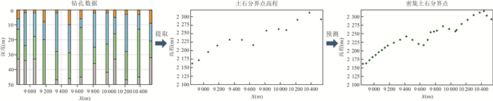
图 1 基于界面高程插值策略流程
Fig. 1. Flowchart of the interpolation strategy using the interface elevation
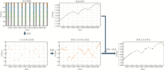
图 2 基于地形高程与界面深度插值策略流程
Fig. 2. Flowchart of the interpolation strategy using topographic elevation and interface depth
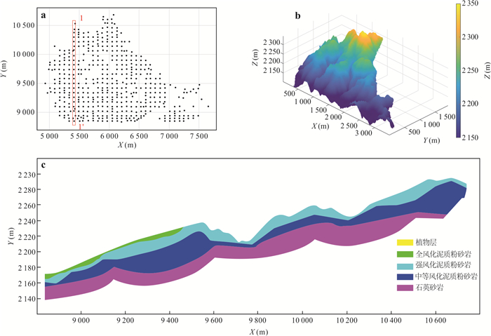
图 3 研究区域的钻孔与地表高程信息及典型地质剖面
a. 钻孔分布图;b. 数字高程模型;c. 典型工程地质剖面图
Fig. 3. Borehole data, ground-surface elevations, and a typical geological profile in the study area
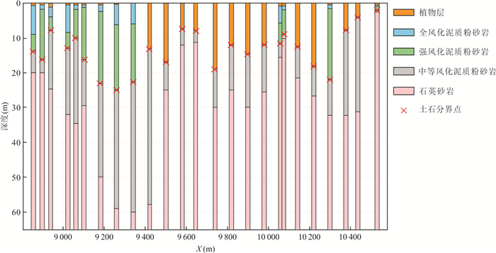
图 4 剖面1-1'内各钻孔岩性与土石分界点
Fig. 4. Lithology and soil-rock interface points for boreholes along section 1-1'
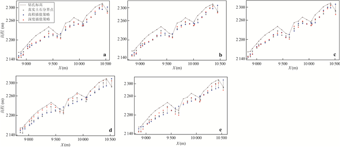
图 5 5种方法在剖面1-1'的留一验证结果
a. IDW留一验证结果;b. RBF核回归留一验证结果;c. GPR留一验证结果;d. MLP留一验证结果;e. KAN留一验证结果
Fig. 5. Leave-one-out cross-validation results of five methods along section 1-1'
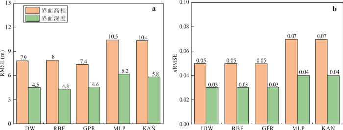
图 6 二维土石界线预测误差
a. RMSE;b. nRMSE
Fig. 6. Prediction errors of the 2D soil-rock interface
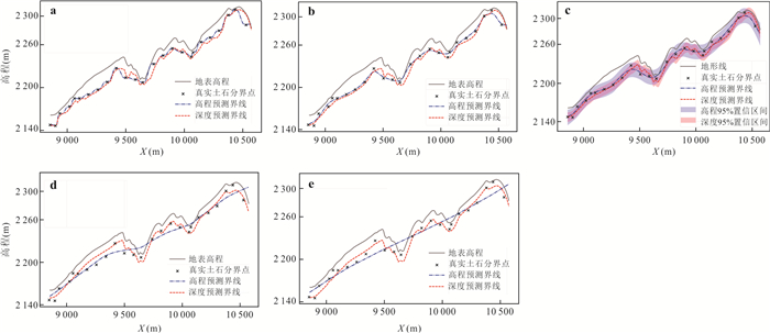
图 7 5种方法在剖面1-1' 的预测结果
a. IDW预测结果;b. RBF核回归预测结果;c. GPR预测结果;d. MLP预测结果;e. KAN预测结果
Fig. 7. Prediction results of five methods along section 1-1'
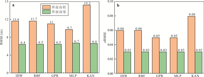
图 8 三维土石界面预测误差
a. 三维数据RMSE;b. 三维数据nRMSE
Fig. 8. Prediction errors of the 3D soil-rock interface
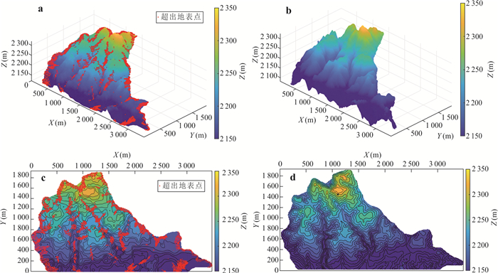
图 9 三维土石界面预测结果
a. 高程插值策略预测结果;b. 深度插值策略预测结果;c. 高程插值策略预测等高线图;d. 深度插值策略预测等高线图
Fig. 9. 3D soil-rock interface prediction results
表 1 文献中土石界面预测方法汇总
Table 1. Overview of soil-rock interface prediction methods in the literature
文献来源 应用场景 预测方法 场地面积(m2) 钻孔(个) 高程差(m) 均方根误差RMSE(m) Samui et al.(2015) 区域勘察 ANFIS 14 000×14 000 652 / 8.8 Samui et al.(2015) 区域勘察 IDW / / / 6.7 Li et al.(2016) 工程勘察 CRF 55×59.3 49 9.4 1.0 Qi et al.(2020) 线路勘察 MARS 3 300×120 173 60 9.3 Qi et al.(2021) 线路勘察 MARS 1 200×400 154 25.6 4.4 Qi et al.(2021) 工程勘察 MARS 550×350 135 54.4 9.2 Qi et al.(2022) 工程勘察 CRF 550×350 135 54.4 7.1 Qi et al.(2022) 线路勘察 TPSI 500×1 000 47 64.1 12.1 Deng et al.(2023) 工程勘察 GPR 160×55 87 / 2.3  下载: 导出CSV
表 2 土、石按开挖难易程度分级规则(《民用机场勘测规范》(MH/T5025))
Table 2. Classification criteria of soil and rock based on the difficulty of excavation
土石等级 土石类别 代表性土、石名称 开挖难易程度 Ⅰ 松土 植物土、中密或松散的砂土和粉土、软塑的粘性土 用铁锹挖,脚蹬一下到底的松散土层 Ⅱ 普通土 稍密或松散的碎石土(不包括块石或漂石)、密实的砂土和粉土、可塑的粘性土 部分用镐刨松,再用锹挖,以脚蹬锹需连蹬数次才能挖动 Ⅲ 硬土 中密的碎石土、硬塑粘性土、风化成土块的岩石 必须用镐整个刨过才能用锹挖 Ⅳ 软石 块石或漂石碎石土、泥岩、泥质砂岩、弱胶结砾岩,中风化~强风化的坚硬岩或较硬岩 部分用撬棍或十子镐及大锤开挖,部分用爆破法开挖 Ⅴ 次坚石 砂岩、硅质页岩、微风化-中等风化的灰岩、玄武岩、花岗岩、正长岩 用爆破法开挖 Ⅵ 坚石 未风化-微风化的玄武岩、石灰岩、白云岩、大理岩、石英岩、闪长岩、花岗岩、正长岩、硅质砾岩等 用爆破法开挖
下载: 导出CSV
表 3 二维土石界线插值各方法最优参数
Table 3. Optimal parameters of different interpolation methods for the 2D soil–rock interface
IDW RBF核回归 GPR MLP KAN 预测高程 k=7; p=2.5 λ=44 C=0.912; l=180 M=2;N1=N2=64 M=1;N1=64 预测深度 k=5; p=3.5 λ=40 C=0.912; l=95.8 M=2;N1=N2=64 M=1;N1=64 注:k为临近点个数,p为幂指数;λ为带宽;C为核函数方差,l为长度尺度;M为隐藏层层数,Ni为第i层神经元的个数.
下载: 导出CSV
表 4 二维土石界线预测结果R2
Table 4. R2 values of the 2D soil-rock interface prediction results
IDW RBF核回归 GPR MLP KAN 预测高程 0.97 0.97 0.97 0.95 0.93 预测深度 0.99 0.99 0.99 0.98 0.98
下载: 导出CSV
表 5 三维土石界面插值各方法最优参数
Table 5. Optimal parameters for different 3D soil–rock interface interpolation methods
IDW RBF核回归 GPR MLP KAN 预测高程 k=6; p=2.5 λ=50 C=0.712; l=86.4 M=2;N1=128;N2=64 M=1;N1 =128 预测深度 k=8; p=1.5 λ=70 C=0.992; l=45.2 M=2;N1=64;N2=32 M=1;N1=64 注:k为临近点个数,p为幂指数;λ为带宽;C为核函数方差,l为长度尺度;M为隐藏层层数,Ni为第i层神经元的个数.
下载: 导出CSV
表 6 三维土石界面预测性能指标R2
Table 6. R2 values for the 3D soil-rock interface prediction performance
IDW RBF核回归 GPR MLP KAN 预测高程 0.95 0.95 0.96 0.97 0.92 预测深度 0.98 0.98 0.98 0.99 0.99
下载: 导出CSV
-
Bai, J., Wang, S., Xu, Q., et al., 2024. Intelligent Regional Subsurface Prediction Based on Limited Borehole Data and Interpretability Stacking Technique of Ensemble Learning. Bulletin of Engineering Geology and the Environment, 83(7): 272. https://doi.org/10.1007/s10064-024-03758-y Chen, C. F., Zhao, N., Yue, T. X., et al., 2015. A Generalization of Inverse Distance Weighting Method via Kernel Regression and Its Application to Surface Modeling. Arabian Journal of Geosciences, 8(9): 6623-6633. https://doi.org/10.1007/s12517-014-1717-z Cordonnier, G., Cani, M. P., Benes, B., et al., 2018. Sculpting Mountains: Interactive Terrain Modeling Based on Subsurface Geology. IEEE Transactions on Visualization and Computer Graphics, 24(5): 1756-1769. https://doi.org/10.1109/TVCG.2017.2689022 Deng, Z. P., Pan, M., Niu, J. T., et al., 2023. Spatial Prediction of Rockhead Profile Using the Gaussian Process Regression Method. Canadian Geotechnical Journal, 60(12): 1849-1860. https://doi.org/10.1139/cgj-2022-0372 Du, X., Fan, T. E., Dong, J. H., et al., 2020. Characterization of Thin Sand Reservoirs Based on a Multi-Layer Perceptron Deep Neural Network. Oil Geophysical Prospecting, 55(6): 1178-1187, 1159 (in Chinese with English abstract). Fu, J. M., Hu, M. S., Fang, F., et al., 2024. Complex Orebody 3D Modeling Using Radial Basis Function Surface Incorporating Stacking Integration Strategy. Earth Science, 49(3): 1165-1176 (in Chinese with English abstract). Huang, D. Z., Zuo, R. G., Wang, J., et al., 2025. Spatially Constrained Variational Autoencoder for Geochemical Data Denoising and Uncertainty Quantification. Journal of Earth Science, 36(5): 2317-2336. https://doi.org/10.1007/s12583-025-0180-y Li, X. Y., Zhang, L. M., Li, J. H., 2016. Using Conditioned Random Field to Characterize the Variability of Geologic Profiles. Journal of Geotechnical and Geoenvironmental Engineering, 142(4): 04015096. https://doi.org/10.1061/(asce)gt.1943-5606.0001428 Li, Z. L., Wu, C. L., Zhang, X. L., et al., 2015. Uncertainty Assessment for IDW Ore Grade Estimates. Earth Science, 40(11): 1796-1801 (in Chinese with English abstract). Liu, Z. M., Wang, Y. X., Vaidya, S., et al., 2024. KAN: Kolmogorov-Arnold Networks. arXiv: 2404.19756. Murphy, K. P., 2012. Machine Learning (4th Printing). The MIT Press, Cambridge, Mass. Murphy, K. P., 2022. Probabilistic Machine Learning. The MIT Press, Cambridge, Mass. Pan, K., Xie, C. Q., Cheng, R. Y., et al., 2017. Engineering Example of Comprehensive Prospecting of Underground Karst in Mountain Airport Area. Site Investigation Science and Technology, (1): 28-32 (in Chinese with English abstract). Qi, X. H., Pan, X. H., Chiam, K., et al., 2020. Comparative Spatial Predictions of the Locations of Soil-Rock Interface. Engineering Geology, 272: 105651. https://doi.org/10.1016/j.enggeo.2020.105651 Qi, X. H., Wang, H., Chu, J., et al., 2022. Two-Dimensional Prediction of the Interface of Geological Formations: A Comparative Study. Tunnelling and Underground Space Technology, 121: 104329. https://doi.org/10.1016/j.tust.2021.104329 Qi, X. H., Wang, H., Pan, X. H., et al., 2021. Prediction of Interfaces of Geological Formations Using the Multivariate Adaptive Regression Spline Method. Underground Space, 6(3): 252-266. https://doi.org/10.1016/j.undsp.2020.02.006 Qiu, Z. L., Wu, J. D., Wan, P., et al., 2025. Experimental Study on the Influence of Soil-Rock Ratio on the Dynamic Compaction Reinforcement Effect of High Fill Gravel Soil Subgrade. Chinese Journal of Underground Space and Engineering, 21(1): 123-130 (in Chinese with English abstract). Samui, P., Kim, D., Viswanathan, R., 2015. Spatial Variability of Rock Depth Using Adaptive Neuro-Fuzzy Inference System (ANFIS) and Multivariate Adaptive Regression Spline (MARS). Environmental Earth Sciences, 73(8): 4265-4272. https://doi.org/10.1007/s12665-014-3711-x Somvanshi, S., Javed, S. A., Islam, M. M., et al., 2026. A Survey on Kolmogorov-Arnold Network. ACM Computing Surveys, 58(2): 1-35. https://doi.org/10.1145/3743128 Su, Z. Y., Li, D. Q., Wang, S., et al., 2025. Large Deformation Analysis of 3D Soil-Rock Mixture Slopes Using SPH-DEM Method. Earth Science (in Chinese with English abstract) (in Press). Wang, J., 2021. An Intuitive Tutorial to Gaussian Processes Regression. arXiv: 2009.10862 Wang, Q., 2011. A Study on Quantitative Research Method about Soil-Rock Ratio in Red-Beds Airports' Excavation Area in Sichuan (Dissertation). Chengdu University of Technology, Chengdu (in Chinese with English abstract). Xie, C. Q., Li, Z. Z., Pan, K., 2015. Study on Method Determining Soil-Rock Ratio in Large-Area Excavation Works in Southwest Karst Mountains. Subgrade Engineering, (2): 1-5, 12 (in Chinese with English abstract). Xie, C. Q., Rong, S. J., Wang, W., 2013. Study on Soil-Rock Ratio of the Projects in Red Bed Area. Subgrade Engineering, (6): 83-88 (in Chinese with English abstract). Zhang, H., Gui, L., Wang, T. F., et al., 2024. Prediction of Quaternary Cover Thickness and 3D Geological Modeling Based on BP Neural Network. Earth Science, 49(2): 550-559 (in Chinese with English abstract). Zhang, L. M., Dasaka, S. M., 2010. Uncertainties in Geologic Profiles versus Variability in Pile Founding Depth. Journal of Geotechnical and Geoenvironmental Engineering, 136(11): 1475-1488. https://doi.org/10.1061/(asce)gt.1943-5606.0000364 Zhang, S. S., Li, Q. C., Li, H., et al., 2025. Intelligent Glacial Lake Identification in Complex Plateau Terrain Regions Using Multi-Source Remote Sensing Data and Mask R-CNN Deep Learning Model. Earth Science, 50(8): 3132-3143 (in Chinese with English abstract). 杜昕, 范廷恩, 董建华, 等, 2020. 基于多层感知机网络的薄储层预测. 石油地球物理勘探, 55(6): 1178-1187, 1159. 扶金铭, 胡茂胜, 方芳, 等, 2024. Stacking集成策略下的径向基函数曲面复杂矿体三维建模方法. 地球科学, 49(3): 1165-1176. doi: 10.3799/dqkx.2022.433 李章林, 吴冲龙, 张夏林, 等, 2015. IDW矿石品位估值结果的不确定性评价. 地球科学, 40(11): 1796-1801. doi: 10.3799/dqkx.2015.160 潘凯, 谢春庆, 程瑞驭, 等, 2017. 山区机场场地地下岩溶综合勘察工程实例. 勘察科学技术(1): 28-32. 仇志龙, 吴嘉栋, 万鹏, 等, 2025. 土石比对高填方碎石土地基强夯加固影响试验研究. 地下空间与工程学报, 21(1): 123-130. 苏正洋, 李典庆, 王顺, 等, 2025. 三维土石混合体边坡大变形SPH-DEM模拟. 地球科学(待刊). 王巧, 2011. 四川红层机场挖方区土石比定量分析方法研究(硕士学位论文). 成都: 成都理工大学. 谢春庆, 李正忠, 潘凯, 2015. 西南某岩溶山区大面积挖方工程确定土石比方法研究. 路基工程, (2): 1-5, 12. 谢春庆, 容树俭, 王伟, 2013. 红层地区工程中土石比研究. 路基工程, (6): 83-88. 张瀚, 桂蕾, 王腾飞, 等, 2024. 基于BP神经网络的第四系覆盖物厚度预测及三维地质建模. 地球科学, 49(2): 550-559. doi: 10.3799/dqkx.2022.173 张世殊, 李青春, 黎昊, 等, 2025. 融合多源遥感数据和改进后Mask R-CNN深度学习模型的复杂高原地形区冰湖智能识别. 地球科学, 50(8): 3132-3143. doi: 10.3799/dqkx.2025.041 -

 点击查看大图
计量
- 文章访问数: 161
- HTML全文浏览量: 16
- PDF下载量: 38
- 被引次数: 0
