




Characterizing Groundwater Recharge-Discharge Processes and Evaluating Soil Submergence Risk in Four-Lake Basin Using SWAT-MODFLOW Coupled Model
-
摘要:
位于江汉平原的四湖流域是长江中游典型的江-河-湖-田多端元系统,生态环境问题突出,为了精确量化四湖流域内主要水系和地下水的交互速率,分析影响流域内土壤潜育化程度的主要因素.利用SWAT-MODFLOW模型构建四湖流域地表水-地下水耦合模型,围绕模型结果,对四湖流域内地表水和地下水交互速率的时空差异以及冷浸田分布情况进行分析探讨.研究结果表明,耦合模型对径流与地下水的模拟效果较好;长江与地下水交换呈现明显季节性转化,春夏季以江水补给地下水为主,秋冬季则地下水排泄入江;流域内长湖交互强度高于洪湖,总干渠上下游表现出不同的交换模式;土壤潜育化风险区(地下水埋深<3 m)主要分布于洪湖周边、总干渠沿线及监利市西北部,受降水入渗、地形和土壤利用类型共同影响.本研究为四湖流域水交换过程与土壤渍涝风险提供了定量依据,可为区域水资源管理与生态保护提供科学支撑.
-
关键词:
- 四湖流域 /
- SWAT-MODFLOW模型 /
- 地表水-地下水交互规律 /
- 土壤潜育化 /
- 水文地质 /
- 环境地质
Abstract:The Four-Lake basin in the Jianghan plain is a typical river-lake-wetland-farmland multi-element system in the Middle Reaches of the Yangtze River, facing prominent eco-environmental challenges. To accurately quantify the exchange rates between major water systems and groundwater in the basin and to analyze the main factors influencing the degree of soil gleyization, this study constructed a loosely coupled surface water-groundwater model for the Four-Lake basin using SWAT-MODFLOW. Based on the simulation results, the spatiotemporal variation in surface water-groundwater exchange rates and the distribution of cold waterlogged paddy field were systematically examined. The results show that the coupled model performs well in simulating both runoff and groundwater dynamics. The exchange between the Yangtze River and groundwater exhibits clear seasonal reversals: river water recharges groundwater in spring and summer, while groundwater discharges into the river in autumn and winter. Within the basin, the interaction intensity of Changhu Lake is higher than that of Hong Lake, and the main canal shows different exchange patterns between its upstream and downstream sections.The risk areas of soil gleyization (groundwater depth <3 m) are mainly distributed around Honghu Lake, along the Four-Lake main canal, and in the northwest of Jianli City, influenced jointly by rainfall infiltration, topography, and land-soil types. This study provides a quantitative basis for understanding water exchange processes and soil waterlogging risks in the Four-Lake basin, offering scientific support for regional water resources management and ecological conservation.
-
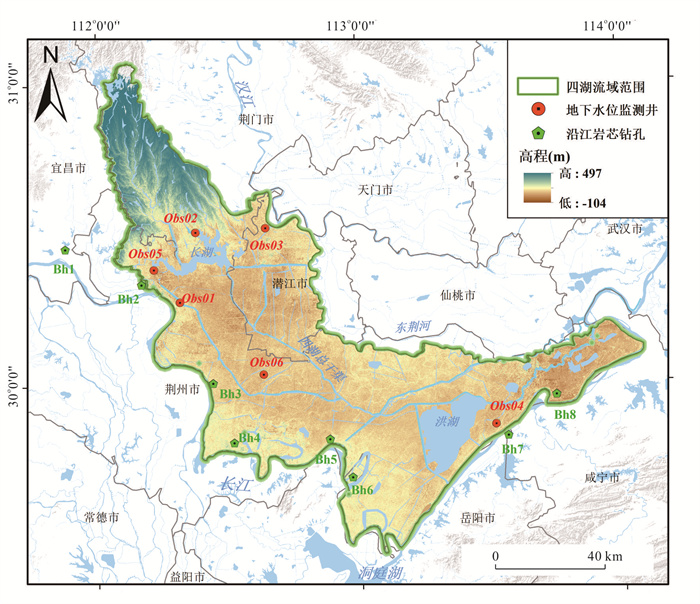
图 1 四湖流域概况、地下水监测井和岩心钻孔分布
Fig. 1. Overview of the Four-Lake basin with distribution of groundwater monitoring wells and core borings
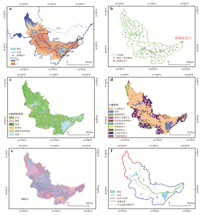
图 2 四湖流域(a)高程、水系和主要排水闸口、(b)SWAT模型子流域划分、(c)土地利用类型、(d)土壤类型、(e)SWAT模型HRUs划分和(f)地下水模型的水文地质参数分区及边界条件设置
Fig. 2. Maps of the Four-Lake basin: (a) elevation, stream network, and main sluices, (b) SWAT model subbasins division; (c) land use classification, (d) soil classification, (e) SWAT model HRUs and (f) hydrogeological parameter zonation and boundary condition configuration for the groundwater model
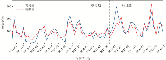
图 3 新滩口站逐月径流量实测值和模拟值变化
Fig. 3. Comparison of observed and simulated monthly runoff at the Xintankou station
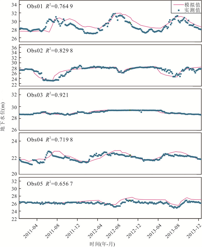
图 4 地下水位监测井观测值和模拟值变化
Fig. 4. Comparison of observed and simulated groundwater levels in monitoring wells
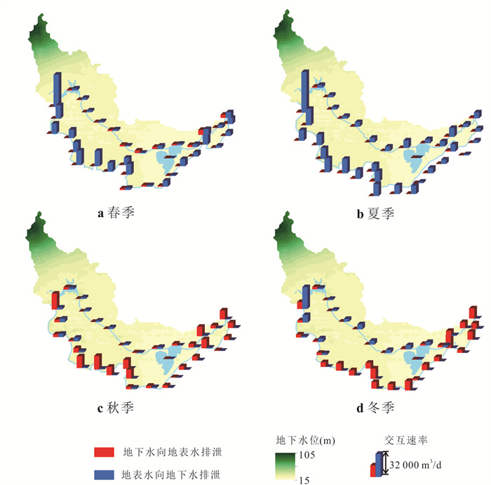
图 5 四湖流域内主要水系(长江、四湖总干渠、洪湖和长湖)在不同季节与地下水的交互速率
Fig. 5. Interaction rates between major surface water bodies (Yangtze River, Four-Lake Main Canal, Honghu Lake, Changhu Lake) and groundwater across seasons in the Four-Lake basin
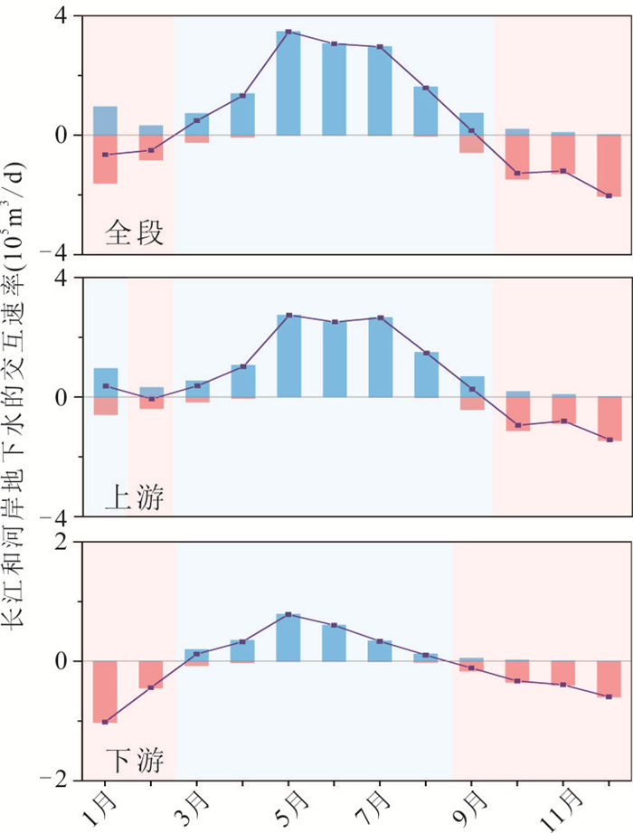
图 6 四湖流域内长江全段、上游和下游分别与河岸地下水的年均(2011—2013年)交互速率
正值表示长江补给地下水,负值表示地下水排泄至长江
Fig. 6. Annual average (2011—2013) interaction rates between the Yangtze River (the entire, upper, and lower reaches) and riparian groundwater in the Four-Lake basin
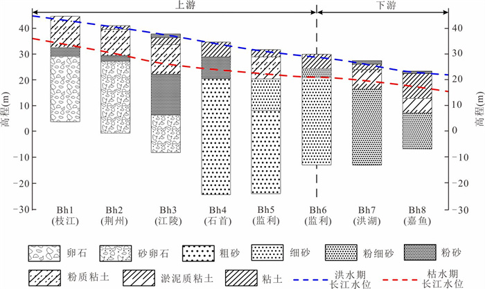
图 7 四湖流域沿江钻孔岩性
Fig. 7. Lithologic logs of boreholes along the Yangtze River in the Four-Lake basin
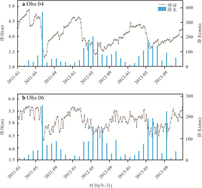
图 8 地下水水位埋深与降雨量变化关系
Fig. 8. Relation diagram of groundwater level depth and rainfall variation
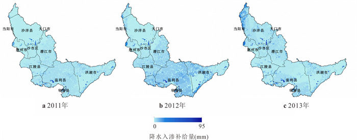
图 9 四湖流域2011—2013年地下水补给量分布
Fig. 9. Distribution of groundwater recharge in the Four-Lake basin (2011—2013)
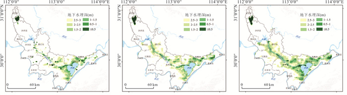
图 10 2011—2013年四湖流域汛期地下水位埋深
Fig. 10. Depth of groundwater table during the flood season in the Four-Lake basin (2011—2013)
表 1 SWAT模型数据类型和来源
Table 1. Data types and sources of the SWAT model
数据类型 数据精度 数据来源 数字高程 30 m×30 m 地理空间数据云( http://www.gscloud.cn )土地利用类型 1 km×1 km 中国科学院资源环境科学与数据平台( https://www.resdc.cn )土壤类型 30 m×30 m 世界土壤学数据库(HWSD)( https://www.fao.org/ )气象数据 1/8°×1/8° 中国气象同化驱动数据集(CMADSV1.2) ( https://poles.tpdc.ac.cn ) 下载: 导出CSV
表 2 四湖流域MODFLOW模型的水文地质参数及分区
Table 2. Hydrogeological parameters and zonation for the MODFLOW model of the Four-Lake basin
水文地质参数分区 水平渗透系数Kx、Ky(m/d) 垂向渗透系数Kz(m/d) 给水度Sy 贮水率Ss(L-1) 潜水含水层 承压含水层 潜水含水层 承压含水层 潜水含水层 承压含水层 1 1.00 9.75 0.150 1.1 0.021 0.000 4 2 1.5 16 0.302 1.6 0.002 2 3 0.79 7.7 0.120 0.85 0.001 0 4 0.54 4.9 0.081 0.57 0.002 3
下载: 导出CSV
表 3 SWAT模型参数率定结果
Table 3. SWAT model parameter calibration results
参数 参数含义 取值范围 最优值 t-value p-value 敏感性 GWQMN 基流判定系数 0~5 000 186.90 -30.89 0.00 1 REVAPMN 浅层地下水再蒸发系数 0~500 188.31 15.60 0.00 2 GW_DELAY 地下水延迟系数 0~500 232.39 -1.97 0.05 3 CH_N2 主河道曼宁系数 -0.01~0.30 0.11 1.91 0.06 4 SOL_BD 土壤湿容重 0.9~2.5 1.13 1.79 0.07 5 CH_N1 支流河道曼宁系数 0.01~30 20.30 -1.48 0.14 6 CH_K2 主河道河床有效水利传导度 -0.01~500 27.39 -1.22 0.22 7 SURLAG 地表径流延迟时间 0.05~24 15.11 -1.21 0.23 8 GW_REVAP 浅层地下水再蒸发系数 0.02~0.20 0.17 -1.20 0.23 9 SOL_AWC 土壤有效水容量 0~1 0.00 0.90 0.37 10 ESCO 土壤蒸发补偿系数 0.01~1 0.36 0.88 0.38 11 OV_N 坡面漫流的曼宁系数 0.01~30 17.89 -0.81 0.42 12 ALPHA_BNK 河岸基流α因子 0~1 0.33 -0.79 0.43 13 ALPHA_BF 基流回退系数 0~1 0.22 -0.47 0.64 14 SOL_K 土壤饱和水力传导度 0~2 000 1 766.62 0.38 0.70 15 EPCO 植物蒸发补偿系数 0.01~1 0.38 0.16 0.87 16 CN2 SCS径流曲线系数 35~98 35.34 -0.01 0.99 17
下载: 导出CSV
-
Aliyari, F., Bailey, R. T., Tasdighi, A., et al., 2019. Coupled SWAT-MODFLOW Model for Large-Scale Mixed Agro-Urban River Basins. Environmental Modelling Software, 115: 200-210. https://doi.org/10.1016/j.envsoft.2019.02.014 Balerna, J. A., Kramer, A. M., Landry, S. M., et al., 2023. Synergistic Effects of Precipitation and Groundwater Extraction on Freshwater Wetland Inundation. Journal of Environmental Management, 337: 117690. https://doi.org/10.1016/j.jenvman.2023.117690 Balerna, J. A., Kramer, A. M., Landry, S. M., et al., 2024. Wetland Hydrological Change and Recovery across Three Decades of Shifting Groundwater Management. Journal of Hydrology, 644: 132052. https://doi.org/10.1016/j.jhydrol.2024.132052 Bi, Y., Rong, Y., Zhao, Y. X., et al., 2025. Identification of Critical Sources and Characteristic Analysis of Nitrogen and Phosphorus Pollution in Yanjin River Basin Based on SWAT Model. China Environmental Science, 45(12): 6881-6891 (in Chinese with English abstract). Deng, K., Yang, S. Y., Lian, E. G., et al., 2016. Three Gorges Dam Alters the Changjiang (Yangtze) River Water Cycle in the Dry Seasons: Evidence from H-O Isotopes. Science of the Total Environment, 562: 89-97. https://doi.org/10.1016/j.scitotenv.2016.03.213 Dong, W. J., Xu, P. Z., Zhang, R. Z., et al., 2013. Effects of Soil Amendments on Soil Properties and Population Quality of Rice in Cold Waterlogged Paddy Field. Chinese Journal of Eco-Agriculture, 21(7): 810-816 (in Chinese with English abstract). doi: 10.3724/SP.J.1011.2013.00810 Du, Y., Ma, T., Deng, Y. M., et al., 2018. Characterizing Groundwater/Surface-Water Interactions in the Interior of Jianghan Plain, Central China. Hydrogeology Journal, 26(4): 1047-1059. https://doi.org/10.1007/s10040-017-1709-7 Feng, J. P., Shao, D. G., Gu, W. Q., et al., 2023. Surface Water–Groundwater Transformation Patterns in the Jianghan Plain after the Impoundment of the Three Gorges Project and the Opening of the Yangtze-to-Hanjiang Water Transfer Project. Water, 15(16): 2952. https://doi.org/10.3390/w15162952 Gao, Y., Zhang, W. L., Li, Y., et al., 2021. Dams Shift Microbial Community Assembly and Imprint Nitrogen Transformation along the Yangtze River. Water Research, 189: 116579. https://doi.org/10.1016/j.watres.2020.116579 Hagage, M., Abdulaziz, A. M., Elbeih, S. F., et al., 2024. Monitoring Soil Salinization and Waterlogging in the Northeastern Nile Delta Linked to Shallow Saline Groundwater and Irrigation Water Quality. Scientific Reports, 14: 27838. https://doi.org/10.1038/s41598-024-77954-x Hu, M. P., Yao, M. Y., Wang, Y. C., et al., 2023. Influence of Nitrogen Inputs, Dam Construction and Landscape Patterns on Riverine Nitrogen Exports in the Yangtze River Basin during 1980-015. Journal of Hydrology, 617: 129109. https://doi.org/10.1016/j.jhydrol.2023.129109 Jiang, X., Ma, R., Ma, T., et al., 2022. Modeling the Effects of Water Diversion Projects on Surface Water and Groundwater Interactions in the Central Yangtze River Basin. Science of the Total Environment, 830: 154606. https://doi.org/10.1016/j.scitotenv.2022.154606 Kirwan, M. L., Megonigal, J. P., 2013. Tidal Wetland Stability in the Face of Human Impacts and Sea-Level Rise. Nature, 504: 53-60 https://doi.org/10.1038/nature12856 Lai, X. H., Zou, H. J., Jiang, J., et al., 2025. Hydrological Dynamics of the Yangtze River-Dongting Lake System after the Construction of the Three Gorges Dam. Scientific Reports, 15: 50. https://doi.org/10.1038/s41598-024-83751-3 Leng, Z. C., Du, Y., Tao, Y. Q., et al., 2022. Coexistence and Controlling Factors of Ammonium and Phosphorus in Groundwater along the Middle Reaches of the Yangtze River. Bulletin of Geological Science and Technology, 41(1): 300-308 (in Chinese with English abstract). Li, W, Chen, X. H., He, Y. H., et al., 2018. Modification of Reservoir Module in SWAT Model and Its Application of Runoff Simulation in Highly Regulated Basin. Tropical Geography, 38(2): 226-235 (in Chinese with English abstract). Li, Y. Y., Guo, J., Cai, A. M., et al., 2023. Characteristics of Groundwater in the Cold Waterlogged Paddy Field of the Jianghan Plain. Resources Environment Engineering, 37(2): 163-170, 216 (in Chinese with English abstract). Miguez-Macho, G., Fan, Y., 2012. The Role of Groundwater in the Amazon Water Cycle: 2. Influence on Seasonal Soil Moisture and Evapotranspiration. Journal of Geophysical Research: Atmospheres, 117(D15): 2012JD017540. https://doi.org/10.1029/2012JD7540 Shuai, P., Chen, X. Y., Song, X. H., et al., 2019. Dam Operations and Subsurface Hydrogeology Control Dynamics of Hydrologic Exchange Flows in a Regulated River Reach. Water Resources Research, 55(4): 2593-2612 https://doi.org/10.1029/2018WR4193 Si, G. H., Yuan, J. F., Xu, X. Y., et al., 2018. Effects of an Integrated Rice-Crayfish Farming System on Soil Organic Carbon, Enzyme Activity, and Microbial Diversity in Waterlogged Paddy Soil. Acta Ecologica Sinica, 38(1): 29-35 https://doi.org/10.1016/j.chnaes.2018.01.005 Wang, J. X., 2015. Study on Coupled Simulation of Watershed Hydrologic Model and Groundwater Numerial Model in Jianghan-Dongting Plain (Dissertation). China University of Geosciences, Wuhan(in Chinese with English abstract). Winter, T. C., 1999. Relation of Streams, Lakes, and Wetlands to Groundwater Flow Systems. Hydrogeology Journal, 7(1): 28-45 https://doi.org/10.1007/s100400050178 Xiao, F., Li, Y. Z., Du, Y., et al., 2014. Monitoring Perennial Sub-Surface Waterlogged Croplands Based on MODIS in Jianghan Plain, Middle Reaches of the Yangtze River. Journal of Integrative Agriculture, 13(8): 1791-1801 https://doi.org/10.1016/S2095-3119(13)60563-8 Yang, Y., Yuan, Y. L., Xiong, G. Y., et al., 2024. Patterns of Nitrate Load Variability under Surface Water-Groundwater Interactions in Agriculturally Intensive Valley Watersheds. Water Research, 267: 122474. https://doi.org/10.1016/j.watres.2024.122474 Yin, S. Z., Xu, F., Wang, W. H., et al., 2022. Simulation of Runoff and Spatio-Temporal Variations of Blue and Green Water Resources in Sihu Basin. Environmental Engineering, 40(5): 133-140 (in Chinese with English abstract). Zhou, M. R., Xia, J. Q., Deng, S. S., et al., 2023. Modelling of Phosphorus and Nonuniform Sediment Transport in the Middle Yangtze River with the Effects of Channel Erosion, Tributary Confluence and Anthropogenic Emission. Water Research, 243: 120304. https://doi.org/10.1016/j.watres.2023.120304 Zhou, Y., Wang, Y. X., Li, Y. L., et al., 2013. Hydrogeochemical Characteristics of Central Jianghan Plain, China. Environmental Earth Sciences, 68(3): 765-778. https://doi.org/10.1007/s12665-012-1778-9 Zhou, Z. H., Du, Y., Sun, X. L., et al., 2024. Quantification of Groundwater Discharge and Its Spatial Variability in Jingjiang Section of Middle Reach of the Yangtze River. Earth Science, 49(4): 1448-1458 (in Chinese with English abstract). 毕杨, 荣易, 赵琰鑫, 等, 2025. 基于SWAT模型的盐津河流域氮磷污染关键源识别及特征解析. 中国环境科学, 45(12): 6881-6891. 董稳军, 徐培智, 张仁陟, 等, 2013. 土壤改良剂对冷浸田土壤特性和水稻群体质量的影响. 中国生态农业学报, 21(7): 810-816. 冷智超, 杜尧, 陶艳秋, 等, 2022. 长江中游沿岸地下水中铵氮与磷的共存规律及其控制因素. 地质科技通报, 41(1): 300-308. 李蔚, 陈晓宏, 何艳虎, 等, 2018. 改进SWAT模型水库模块及其在水库控制流域径流模拟中的应用. 热带地理, 38(2): 226-235. 李亚云, 郭静, 蔡爱民, 等, 2023. 江汉平原冷浸田地区地下水特征研究. 资源环境与工程, 37(2): 163-170, 216. 王军霞, 2015. 江汉-洞庭平原流域水文模型与地下水数值模型耦合模拟研究(博士学位论文). 武汉: 中国地质大学. 尹述政, 许峰, 王文荟, 等, 2022. 四湖流域径流及蓝水绿水资源时空分布模拟. 环境工程, 40(5): 133-140. 周子皓, 杜尧, 孙晓梁, 等, 2024. 长江中游荆江段地下水排泄的量化及其空间差异性分析. 地球科学, 49(4): 1448-1458. -

 点击查看大图
计量
- 文章访问数: 195
- HTML全文浏览量: 11
- PDF下载量: 40
- 被引次数: 0
