




Snow Cover Reconstruction via Multisource Data Fusion Using Fengyun Satellites in Upper Jinsha River Basin
-
摘要: 为了解决云层覆盖导致的积雪覆盖遥感监测产品数据缺失的问题,提出了一种基于风云卫星等多源数据融合的雪盖重建方法,通过7个去云步骤实现了金沙江上游高精度逐日无云雪盖监测.结果显示,融合后的雪盖产品总体精度能达到0.94,Kappa系数为0.80,比广泛使用的美国IMS雪冰产品的积雪监测效果更好.然而,融合雪盖产品的总体精度在海拔4.3 km和5.6 km左右有轻微下降,且产品精度随坡向的变化而出现差异.此外,融合雪盖产品在森林地区的精确率(0.18)远小于其他地区.未来在改进雪盖重建方法时,应考虑不同坡向的积雪分布以及森林地区的积雪特征,以提升多源融合无云雪盖产品的精度.Abstract: To address the issue of missing data in snow cover products caused by cloud contamination in remote sensing imagery, this study proposes a snow cover reconstruction method based on the fusion of multisource data, including Fengyun satellite observations. A seven-step cloud removal process was employed to achieve daily, accurate, cloud-free snow cover monitoring in the upper Jinsha River basin. The results indicate that the reconstructed snow cover product attains an overall accuracy of 0.94 and a Kappa coefficient of 0.80, outperforming the widely used IMS product from the United States. However, the overall accuracy slightly declines within snow transition zones at altitudes of approximately 4.3 km and 5.6 km, and it varies according to slope aspect. Moreover, the precision of the reconstructed product in forested areas is considerably lower (0.18) than in other land cover types. Future enhancements to the reconstruction method should incorporate slope aspect and forest-specific characteristics to improve the accuracy of multisource fused, cloud-free snow cover products.
-
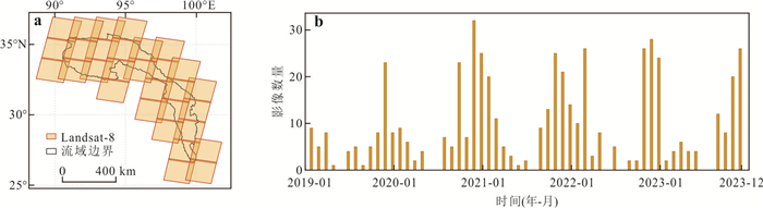
图 2 用于精度检验的Landsat-8影像的时空分布
a. Landsat-8 WRS-2分幅条带矢量图;b. 所使用的Landsat-8影像逐月数量分布
Fig. 2. Spatiotemporal distribution of Landsat-8 images used for accuracy assessment
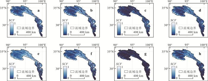
图 5 融合雪盖产品分别在(a)冬季、(b)春季、(c)夏季和(d)秋季的SCF,以及IMS雪冰产品分别在(e)冬季、(f)春季、(g)夏季和(h)秋季的SCF
Fig. 5. Snow cover frequency (SCF) of the reconstructed snow cover products in winter (a), spring (b), summer (c), and autumn (d), and SCF of the IMS products in winter (e), spring (f), summer (g), and autumn (h)

图 6 融合雪盖产品和IMS产品分别在冬季(a)、春季(b)、夏季(c)和秋季(d)的像元SCF出现频率分布
Fig. 6. Frequency distribution of SCF for the reconstructed snow cover products and IMS products in winter (a), spring (b), summer (c), and autumn (d)

图 7 2019—2023年融合雪盖产品和IMS的精确率(a)、召回率(b)、总体精度(c)、Kappa系数(d)和F1分数(e)
Fig. 7. Precision (a), recall (b), overall accuracy (c), Kappa coefficient (d), and F1-score (e) of the reconstructed snow cover products and IMS products from 2019 to 2023
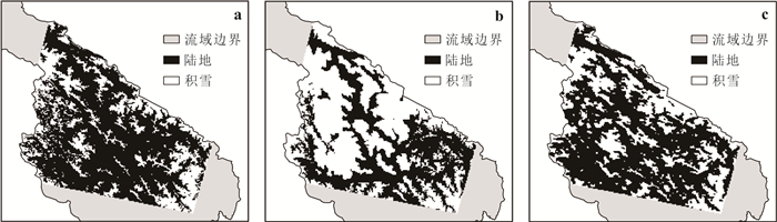
图 8 2019年1月11日金沙江上游局部积雪分布
a. Landsat-8影像;b. IMS产品;c. 融合产品
Fig. 8. Local snow distribution in the upper Jinsha River on January 11, 2019
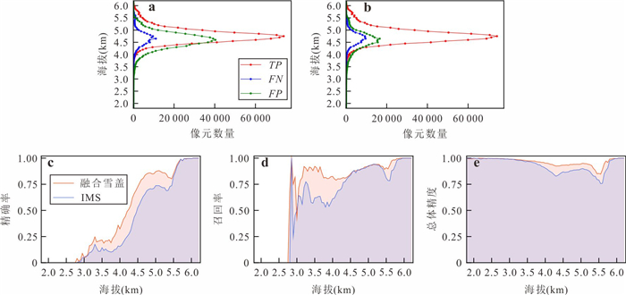
图 9 2019—2023年融合雪盖和IMS产品精度随海拔高程的变化
a. IMS产品的像元数量随高程的变化;b. 融合雪盖产品的像元数量随高程的变化;c. 产品精确率随高程的变化;d. 召回率随高程的变化;e. 总体精度随高程的变化
Fig. 9. Variation in the accuracy of reconstructed snow cover and IMS products with altitude from 2019 to 2023
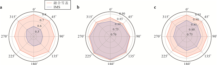
图 10 2019—2023年融合雪盖和IMS产品精度随坡向的变化
a. 精确率;b. 召回率;c.总体精度
Fig. 10. Variation in the accuracy of reconstructed snow cover and IMS products with slope aspect from 2019 to 2023
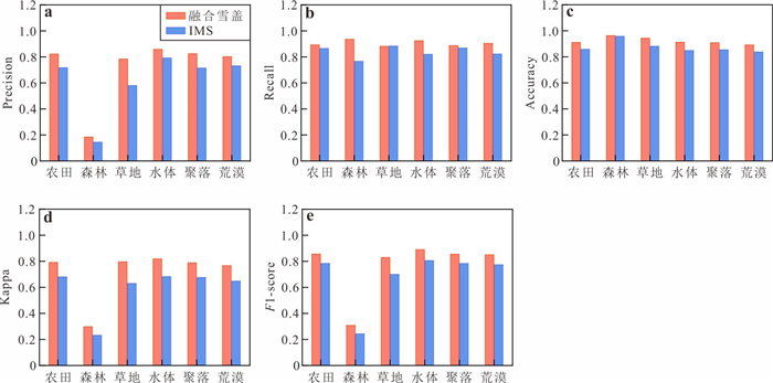
图 11 2019—2023年融合雪盖和IMS产品精度随土地覆盖类型的变化
a. 精确率;b. 召回率;c. 总体精度;d. Kappa系数;e. F1分数
Fig. 11. Variation in the accuracy of reconstructed snow cover and IMS products with land cover types from 2019 to 2023
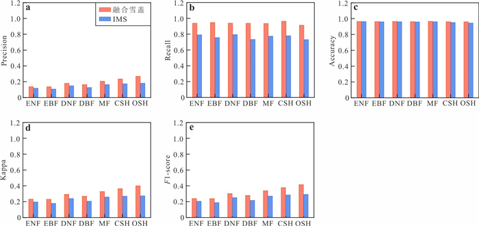
图 12 2019—2023年融合雪盖和IMS产品在不同森林类型下的精度变化
常绿针叶林:ENF,常绿阔叶林:EBF,落叶针叶林:DNF,落叶阔叶林:DBF,混生林MF,郁闭灌丛CSH,稀疏灌丛OSH;a. 精确率;b. 召回率;c. 总体精度;d. Kappa系数;e. F1分数图
Fig. 12. Variation in the accuracy of reconstructed snow cover and IMS products across different forest types from 2019 to 2023
表 1 主要数据源特性
Table 1. Characteristics of the main data sources
数据源 时间分辨率 空间分辨率 重采样方法 重采样后的分辨率 重分类后的像元 FY-3D 1 d 1 km - 除站点观测外,其他数据的空间分辨率均与FY-3D保持一致,为1 km 无雪地表(25)、湖泊(37)、海洋(39)、云(50)、海/湖冰(100)、积雪(200) Terra/Aqua MODIS 1 d 500 m 众数重采样 IMS 1 d 1 km 最邻近重采样 站点观测 1 d - - 无雪地表(25)、积雪(200) Landsat-8 16 d 30 m 双三次插值 DEM - 30 m 双线性插值 -  下载: 导出CSV
表 3 多源融合雪盖重建算法每一步骤的云覆盖百分比
Table 3. Cloud coverage percentages at each step of the snow cover reconstruction algorithm
FY3D_SNC Step 1 Step 2 Step 3 Step 4 Step 5 Step 6 Step 7 2019年 53.02% 43.23% 38.25% 21.66% 18.55% 16.12% 5.07% 0 2020年 52.87% 39.65% 32.35% 16.65% 13.96% 12.23% 4.25% 0 2021年 52.72% 36.52% 30.34% 15.75% 13.64% 11.77% 3.37% 0 2022年 55.07% 39.20% 31.77% 16.91% 14.20% 12.41% 3.79% 0 2023年 58.24% 38.92% 32.82% 18.39% 15.95% 13.78% 4.69% 0
下载: 导出CSV
表 4 融合雪盖产品和IMS总体精度表
Table 4. The accuracy of the reconstructed snow cover products and IMS products
Precision Recall Accuracy Kappa F1-score 融合雪盖产品 0.78 0.89 0.94 0.80 0.83 IMS 0.60 0.87 0.88 0.64 0.71
下载: 导出CSV
-
Bousbaa, M., Boudhar, A., Kinnard, C., et al., 2024. An Accurate Snow Cover Product for the Moroccan Atlas Mountains: Optimization of the MODIS NDSI Index Threshold and Development of Snow Fraction Estimation Models. International Journal of Applied Earth Observation and Geoinformation, 129: 103851. https://doi.org/10.1016/j.jag.2024.103851 Che, T., Li, X., Jin, R., et al., 2008. Snow Depth Derived from Passive Microwave Remote-Sensing Data in China. Annals of Glaciology, 49: 145-154. https://doi.org/10.3189/172756408787814690 Chu, D., Zheng, Z. J., Laba, Z. M., et al., 2021. Accuracy Assessment of IMS 4 km Snow and Ice Products on the Tibetan Plateau Based on Landsat-8 OLI Images. Remote Sensing Technology and Application, 36(6): 1223-1235 (in Chinese with English abstract). Dietz, A. J., Kuenzer, C., Gessner, U., et al., 2012. Remote Sensing of Snow: A Review of Available Methods. International Journal of Remote Sensing, 33(13): 4094-4134. https://doi.org/10.1080/01431161.2011.640964 Dixit, A., Goswami, A., Jain, S., 2019. Development and Evaluation of a New "Snow Water Index (SWI)" for Accurate Snow Cover Delineation. Remote Sensing, 11(23): 2774. https://doi.org/10.3390/rs11232774 Dong, C. Y., Menzel, L., 2016. Producing Cloud-Free MODIS Snow Cover Products with Conditional Probability Interpolation and Meteorological Data. Remote Sensing of Environment, 186: 439-451. https://doi.org/10.1016/j.rse.2016.09.019 Dong, Z. W., Jiang, H. C., Baccolo, G., et al., 2023. Biological and Pollution Aerosols on Snow and Ice-Interplay between the Atmosphere and the Cryosphere. Journal of Earth Science, 34(6): 1951-1956. https://doi.org/10.1007/s12583-023-2004-2 Gafurov, A., Bárdossy, A., 2009. Cloud Removal Methodology from MODIS Snow Cover Product. Hydrology and Earth System Sciences, 13(7): 1361-1373. https://doi.org/10.5194/hess-13-1361-2009 Gafurov, A., Lüdtke, S., Unger-Shayesteh, K., et al., 2016. MODSNOW-Tool: An Operational Tool for Daily Snow Cover Monitoring Using MODIS Data. Environmental Earth Sciences, 75(14): 1078. https://doi.org/10.1007/s12665-016-5869-x Gao, M., Gu, X. F., Liu, Y., et al., 2022. An Improved Spatiotemporal Data Fusion Method for Snow-Covered Mountain Areas Using Snow Index and Elevation Information. Sensors, 22(21): 8524. https://doi.org/10.3390/s22218524 Gao, Y., Xie, H. J., Yao, T. D., et al., 2010. Integrated Assessment on Multi-Temporal and Multi-Sensor Combinations for Reducing Cloud Obscuration of MODIS Snow Cover Products of the Pacific Northwest USA. Remote Sensing of Environment, 114(8): 1662-1675. https://doi.org/10.1016/j.rse.2010.02.017 Grünewald, T., Bühler, Y., Lehning, M., 2014. Elevation Dependency of Mountain Snow Depth. The Cryosphere, 8(6): 2381-2394. https://doi.org/10.5194/tc-8-2381-2014 Hall, D. K., Riggs, G. A., 2007. Accuracy Assessment of the MODIS Snow Products. Hydrological Processes, 21(12): 1534-1547. https://doi.org/10.1002/hyp.6715 Hall, D. K., Riggs, G. A., DiGirolamo, N. E., et al., 2019. Evaluation of MODIS and VIIRS Cloud-Gap-Filled Snow-Cover Products for Production of an Earth Science Data Record. Hydrology and Earth System Sciences, 23(12): 5227-5241. https://doi.org/10.5194/hess-23-5227-2019 Han, P. F., Long, D., Han, Z. Y., et al., 2019. Improved Understanding of Snowmelt Runoff from the Headwaters of China's Yangtze River Using Remotely Sensed Snow Products and Hydrological Modeling. Remote Sensing of Environment, 224: 44-59. https://doi.org/10.1016/j.rse.2019.01.041 Hand, D. J., Christen, P., Kirielle, N., 2021. F*: An Interpretable Transformation of the F-Measure. Machine Learning, 110(3): 451-456. https://doi.org/10.1007/s10994-021-05964-1 Hori, M., Sugiura, K., Kobayashi, K., et al., 2017. A 38-Year (1978-2015) Northern Hemisphere Daily Snow Cover Extent Product Derived Using Consistent Objective Criteria from Satellite-Borne Optical Sensors. Remote Sensing of Environment, 191: 402-418. https://doi.org/10.1016/j.rse.2017.01.023 Hou, X. G., Zheng, Z. J., Li, S., et al., 2018. Generation of Daily Cloudless Snow Cover Product in the Past 15 Years in Xinjiang and Accuracy Validation. Remote Sensing for Land Resources, 30(2): 214-222 (in Chinese with English abstract). Huang, J. Y., Jiang, L. M., Pan, F. B., et al., 2025. Estimation and Evaluation of the FY-3D/MERSI-Ⅱ Fractional Snow Cover in China. IEEE Journal of Selected Topics in Applied Earth Observations and Remote Sensing, 18: 2497-2511. https://doi.org/10.1109/JSTARS.2024.3517845 Huang, X. D., Ma, Y., Li, Y. X., et al., 2023. Spatiotemporal Variation Characteristics of Snow Cover over the Tibetan Plateau from 1980 to 2020. Journal of Glaciology and Geocryology, 45(2): 423-434 (in Chinese with English abstract). John, A., Cannistra, A. F., Yang, K. H., et al., 2022. High-Resolution Snow-Covered Area Mapping in Forested Mountain Ecosystems Using Planet Scope Imagery. Remote Sensing, 14(14): 3409. https://doi.org/10.3390/rs14143409 Li, X. H., Jing, Y. H., Shen, H. F., et al., 2019. The Recent Developments in Cloud Removal Approaches of MODIS Snow Cover Product. Hydrology and Earth System Sciences, 23(5): 2401-2416. https://doi.org/10.5194/hess-23-2401-2019 Liu, A. W., Che, T., Huang, X. D., et al., 2022. Effect of Cloud Mask on the Consistency of Snow Cover Products from MODIS and VIIRS. Remote Sensing, 14(23): 6134. https://doi.org/10.3390/rs14236134 Liu, Y., Yang, J. M., Chen, X., et al., 2024. Moderate-Resolution Snow Depth Product Retrieval from Passive Microwave Brightness Data over Xinjiang Using Machine Learning Approach. International Journal of Digital Earth, 17(1): 2299208. https://doi.org/10.1080/17538947.2023.2299208 Luo, J. F., Dong, C. Y., Lin, K. R., et al., 2022. Mapping Snow Cover in Forests Using Optical Remote Sensing, Machine Learning and Time-Lapse Photography. Remote Sensing of Environment, 275: 113017. https://doi.org/10.1016/j.rse.2022.113017 López-Burgos, V., Gupta, H. V., Clark, M., 2013. Reducing Cloud Obscuration of MODIS Snow Cover Area Products by Combining Spatio-Temporal Techniques with a Probability of Snow Approach. Hydrology and Earth System Sciences, 17(5): 1809-1823. https://doi.org/10.5194/hess-17-1809-2013 Mao, K. B., Yuan, Z. J., Zuo, Z. Y., et al., 2019. Changes in Global Cloud Cover Based on Remote Sensing Data from 2003 to 2012. Chinese Geographical Science, 29(2): 306-315. https://doi.org/10.1007/s11769-019-1030-6 Motiee, S., Motiee, H., Ahmadi, A., 2024. Analysis of Rapid Snow and Ice Cover Loss in Mountain Glaciers of Arid and Semi-Arid Regions Using Remote Sensing Data. Journal of Arid Environments, 222: 105153. https://doi.org/10.1016/j.jaridenv.2024.105153 Muhuri, A., Gascoin, S., Menzel, L., et al., 2021. Performance Assessment of Optical Satellite-Based Operational Snow Cover Monitoring Algorithms in Forested Landscapes. IEEE Journal of Selected Topics in Applied Earth Observations and Remote Sensing, 14: 7159-7178. https://doi.org/10.1109/JSTARS.2021.3089655 Musselman, K. N., Addor, N., Vano, J. A., et al., 2021. Winter Melt Trends Portend Widespread Declines in Snow Water Resources. Nature Climate Change, 11(5): 418-424. https://doi.org/10.1038/s41558-021-01014-9 Parajka, J., Holko, L., Kostka, Z., et al., 2012. MODIS Snow Cover Mapping Accuracy in a Small Mountain Catchment—Comparison between Open and Forest Sites. Hydrology and Earth System Sciences, 16(7): 2365-2377. https://doi.org/10.5194/hess-16-2365-2012 Paudel, K. P., Andersen, P., 2011. Monitoring Snow Cover Variability in an Agropastoral Area in the Trans Himalayan Region of Nepal Using MODIS Data with Improved Cloud Removal Methodology. Remote Sensing of Environment, 115(5): 1234-1246. https://doi.org/10.1016/j.rse.2011.01.006 Qin, Y., Ding J. L., Zhao, Q. D., et al., 2018. Spatial-Temporal Variation of Snow Cover in the Tianshan Mountains from 2001 To 2015, and Its Relation to Temperature and Precipitation. Journal of Glaciology and Geocryology, 40(2): 249-260 (in Chinese with English abstract). Ren, Z. C., Zhu, H. Z., Liu, X. N., 2012. Spatio-Temporal Differentiation of Land Covers on Annual Scale and Its Response to Climate and Topography in Arid and Semi-Arid Region. Transactions of the Chinese Society of Agricultural Engineering (Transactions of the CSAE), 28(15): 205-214 (in Chinese with English abstract). Sönmez, I., Tekeli, A. E., Erdi, E., 2014. Snow Cover Trend Analysis Using Interactive Multisensor Snow and Ice Mapping System Data over Turkey. International Journal of Climatology, 34(7): 2349-2361. https://doi.org/10.1002/joc.3843 Sun, N., Wigmosta, M., Zhou, T., et al., 2018. Evaluating the Functionality and Streamflow Impacts of Explicitly Modelling Forest-Snow Interactions and Canopy Gaps in a Distributed Hydrologic Model. Hydrological Processes, 32(13): 2128-2140. https://doi.org/10.1002/hyp.13150 Wang, L., Cao, H., Li, Y. R., et al., 2022a. Attribution Analysis of Runoff in the Upper Reaches of Jinsha River, China. Water, 14(17): 2768. https://doi.org/10.3390/w14172768 Wang, Y. C., Su, J. Y., Zhai, X. J., et al., 2022b. Snow Coverage Mapping by Learning from Sentinel-2 Satellite Multispectral Images via Machine Learning Algorithms. Remote Sensing, 14(3): 782. https://doi.org/10.3390/rs14030782 Warren, S. G., 2019. Optical Properties of Ice and Snow. Philosophical Transactions of the Royal Society A: Mathematical, Physical and Engineering Sciences, 377(2146): 20180161. https://doi.org/10.1098/rsta.2018.0161 Wei, X., Shen, Y., Wang, Y., et al., 2025. Textural and Mineralogical Characterization of Moraine from the Galongla Glacier: Insights into Climate-Driven Glacial Degradation in Southeast Xizang. Journal of Earth Science. https://doi.org/10.1007/s12583-025-0236-z Yang, K., John, A., Shean, D., et al., 2023. High-Resolution Mapping of Snow Cover in Montane Meadows and Forests Using Planet Imagery and Machine Learning. Frontiers in Water, 5. https://doi.org/10.3389/frwa.2023.1128758 Yang, K., Yan, K., Zhang, X. J., et al., 2024. Assessing FY-3D MERSI-Ⅱ Observations for Vegetation Dynamics Monitoring: A Performance Test of Land Surface Reflectance. IEEE Transactions on Geoscience and Remote Sensing, 62: 4401920. https://doi.org/10.1109/TGRS.2023.3348997 Yang, Y., Chen, R. S., Liu, G. H., et al., 2022. Trends and Variability in Snowmelt in China under Climate Change. Hydrology and Earth System Sciences, 26(2): 305-329. https://doi.org/10.5194/hess-26-305-2022 Yao, T. D., Bolch, T., Chen, D. L., et al., 2022. The Imbalance of the Asian Water Tower. Nature Reviews Earth Environment, 3(10): 618-632. https://doi.org/10.1038/s43017-022-00299-4 Yi, Y., Liu, S. Y., Zhang, X. H., et al., 2023. Spring Floods and Their Major Influential Factors in the Upper Reaches of Jinsha River Basin during 2001-2020. Journal of Hydrology: Regional Studies, 45: 101318. https://doi.org/10.1016/j.ejrh.2023.101318 You, Q. L., Wu, T., Shen, L. C., et al., 2020. Review of Snow Cover Variation over the Tibetan Plateau and Its Influence on the Broad Climate System. Earth-Science Reviews, 201: 103043. https://doi.org/10.1016/j.earscirev.2019.103043 Yun, B. X., Lei, B. Y., Chen, J. N., et al., 2024. SpecTr: Spectral Transformer for Microscopic Hyperspectral Pathology Image Segmentation. IEEE Transactions on Circuits and Systems for Video Technology, 34(6): 4610-4624. https://doi.org/10.1109/TCSVT.2023.3326196 Zhang, H. B., Zhang, F., Zhang, G. Q., et al., 2019. Ground-Based Evaluation of MODIS Snow Cover Product V6 across China: Implications for the Selection of NDSI Threshold. Science of the Total Environment, 651: 2712-2726. https://doi.org/10.1016/j.scitotenv.2018.10.128 Zhang, Y. L., Qin, X., Li, X., et al., 2020. Estimation of Shortwave Solar Radiation on Clear-Sky Days for a Valley Glacier with Sentinel-2 Time Series. Remote Sensing, 12(6): 927. https://doi.org/10.3390/rs12060927 Zhang, Y. L., Song, Y. Y., Ye, C. Q., et al., 2023. An Integrated Approach to Reconstructing Snow Cover under Clouds and Cloud Shadows on Sentinel-2 Time-Series Images in a Mountainous Area. Journal of Hydrology, 619: 129264. https://doi.org/10.1016/j.jhydrol.2023.129264 Zhang, L. H., Zhang, H. B., Sun, X. Y., et al., 2024. Combined Use of Multiple Cloud-Free Snow Cover Products in China and Its High-Mountain Region: Implications from Snow Cover Identification to Snow Phenology Detection. Water Resources Research, 60(6): e2023WR036274. https://doi.org/10.1029/2023WR036274 Zheng, X. P., Hui, F. M., Huang, Z. H., et al., 2022. Ice/Snow Surface Temperature Retrieval from Chinese FY-3D MERSI-Ⅱ Data: Algorithm and Preliminary Validation. IEEE Transactions on Geoscience and Remote Sensing, 60: 4512715. https://doi.org/10.1109/TGRS.2022.3212095 除多, 郑照军, 拉巴卓玛, 等, 2021. 基于Landsat-8 OLI的青藏高原IMS 4 km雪冰产品精度评价. 遥感技术与应用, 36(6): 1223-1235. 侯小刚, 郑照军, 李帅, 等, 2018. 近15年新疆逐日无云积雪覆盖产品生成及精度验证. 国土资源遥感, 30(2): 214-222. 黄晓东, 马英, 李雨馨, 等, 2023.1980—2020年青藏高原积雪时空变化特征. 冰川冻土, 45(2): 423-434. 秦艳, 丁建丽, 赵求东, 等, 2018.2001—2015年天山山区积雪时空变化及其与温度和降水的关系. 冰川冻土, 40(2): 249-260. 任正超, 朱华忠, 柳小妮, 2012. 年际尺度上土地覆盖类型时空分异及其对气候和地形的响应. 农业工程学报, 28(15): 205-214. -

 点击查看大图
计量
- 文章访问数: 26
- HTML全文浏览量: 16
- PDF下载量: 5
- 被引次数: 0
