2002 Vol. 27, No. 1
Display Method:
2002, 27(1): 1-3.
 PDF 349KB
Abstract:
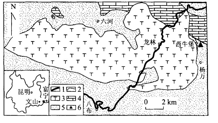
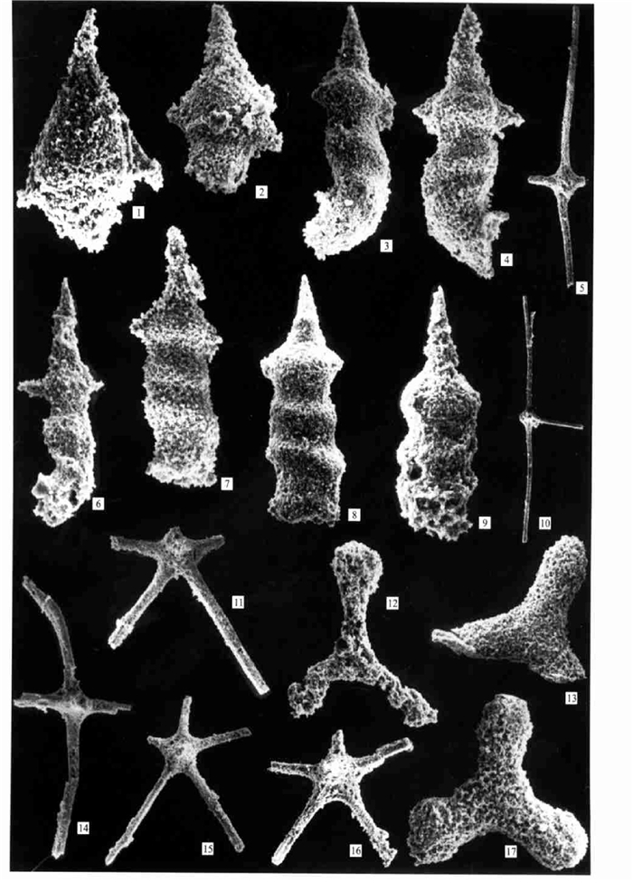
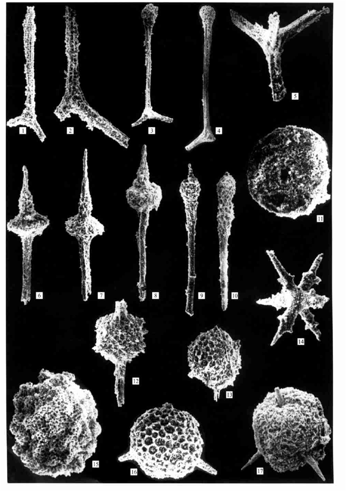
The Early Permian radiolarians were found from the chert of the Babu ophiolitic mélange in southeastern Yunnan. This radiolarian assemblage includes Pseudoalbaillella scalprata scalprata Holdsworth and Jones, Pseudoalbaillella sakmarensis (Kozur), Pseudoalbaillella lomentaria Ishiga and Imoto, Quadriremis robusta Nazarov and Ormiston, Polyfistula hexalobata Nazarov and Ormiston, Latentifistula texana Nazarov and Ormiston, Latentifistula crux Nazarov and Ormiston, Tormentum sertulum Nazarov and Ormiston, Nazarovella phlogidea Wang, Ormistonella robusta De Wever and Caridroit, Hegleria mammilla (Sheng and Wang), et al. It is characterized by Pseudoalbaillella lomentaria and can be correlated with the Early Permian radiolarian assemblages of Japan, USA and southwestern China. This discovery indicates that the Early Permian basin between Yangtze platform and Indosinian Massif was a wide pelagic basin.
The Early Permian radiolarians were found from the chert of the Babu ophiolitic mélange in southeastern Yunnan. This radiolarian assemblage includes Pseudoalbaillella scalprata scalprata Holdsworth and Jones, Pseudoalbaillella sakmarensis (Kozur), Pseudoalbaillella lomentaria Ishiga and Imoto, Quadriremis robusta Nazarov and Ormiston, Polyfistula hexalobata Nazarov and Ormiston, Latentifistula texana Nazarov and Ormiston, Latentifistula crux Nazarov and Ormiston, Tormentum sertulum Nazarov and Ormiston, Nazarovella phlogidea Wang, Ormistonella robusta De Wever and Caridroit, Hegleria mammilla (Sheng and Wang), et al. It is characterized by Pseudoalbaillella lomentaria and can be correlated with the Early Permian radiolarian assemblages of Japan, USA and southwestern China. This discovery indicates that the Early Permian basin between Yangtze platform and Indosinian Massif was a wide pelagic basin.
2002, 27(1): 4-12.
Abstract:
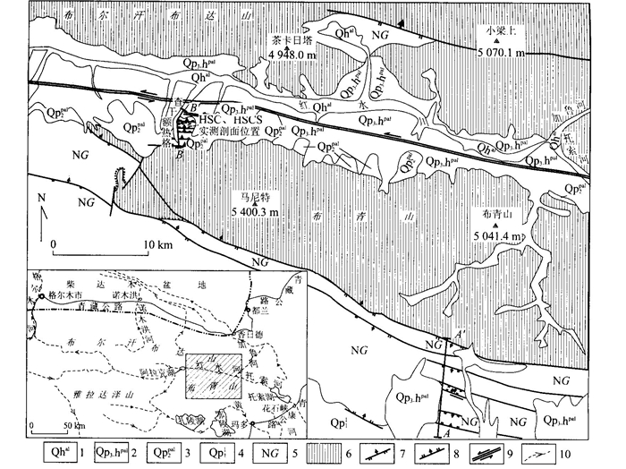
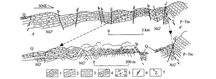
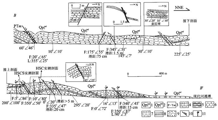
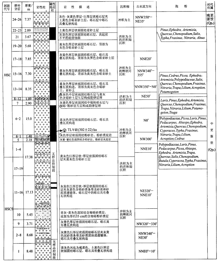
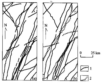
The analysis of the relationship between the Quaternary structure and the relief in the east of eastern Kunlun reveals that the modern relief framework with alternating basins and ridges were formed in the Middle Pleistocene. Multiple deformation system changes have occurred since that time based on the analysis of the structures, strata age and the relationship between structures and rocks from a well displayed Quaternary cross section. In the Middle Pleistocene, the N S extension caused differential uplifting in the Kunlun Mountains. The Buqingshan and Buerhanbudashan popped up the plateau plane. At the end of the Middle Pleistocene, the stress system changed quickly from N S extension to N S compression, then to extension again. The short N S compression event caused folding of the Middle Pleistocene strata on the northern side of Buqingshan, and southward, the thrust folding on its southern side. Soon after the compression event, the N S extension appears again, leading to the step normal faults on the northern side of the Buqingshan and the graben horst assemblage, which overprinted to the previous thrust fold assemblage in the Tertiary Guide Group of the southern slope of the Buqingshan. While in the Late Pleistocene, an important change occurred again in the stress system. The E W transpressive sinistral strike slip faults became active and has remained till now. The multiple age stress change during Quaternary suggests that the uplift mechanism and the mountain building processes are multiplex and complex.
The analysis of the relationship between the Quaternary structure and the relief in the east of eastern Kunlun reveals that the modern relief framework with alternating basins and ridges were formed in the Middle Pleistocene. Multiple deformation system changes have occurred since that time based on the analysis of the structures, strata age and the relationship between structures and rocks from a well displayed Quaternary cross section. In the Middle Pleistocene, the N S extension caused differential uplifting in the Kunlun Mountains. The Buqingshan and Buerhanbudashan popped up the plateau plane. At the end of the Middle Pleistocene, the stress system changed quickly from N S extension to N S compression, then to extension again. The short N S compression event caused folding of the Middle Pleistocene strata on the northern side of Buqingshan, and southward, the thrust folding on its southern side. Soon after the compression event, the N S extension appears again, leading to the step normal faults on the northern side of the Buqingshan and the graben horst assemblage, which overprinted to the previous thrust fold assemblage in the Tertiary Guide Group of the southern slope of the Buqingshan. While in the Late Pleistocene, an important change occurred again in the stress system. The E W transpressive sinistral strike slip faults became active and has remained till now. The multiple age stress change during Quaternary suggests that the uplift mechanism and the mountain building processes are multiplex and complex.
2002, 27(1): 13-18.
Abstract:
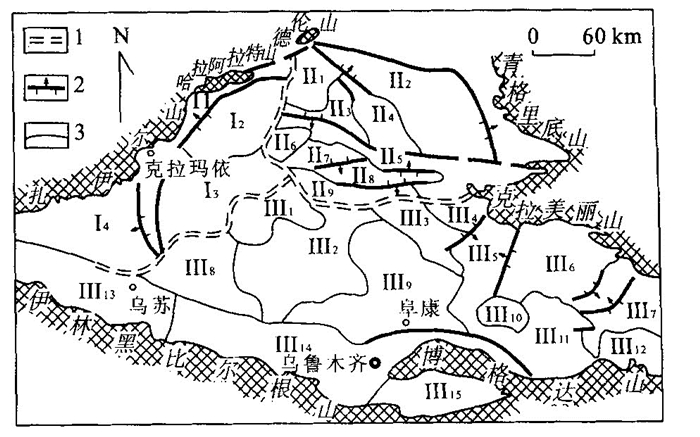
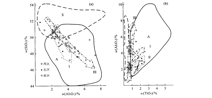
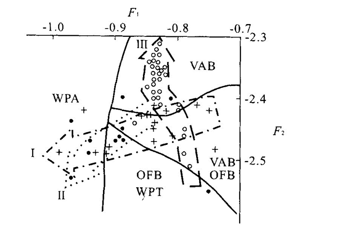
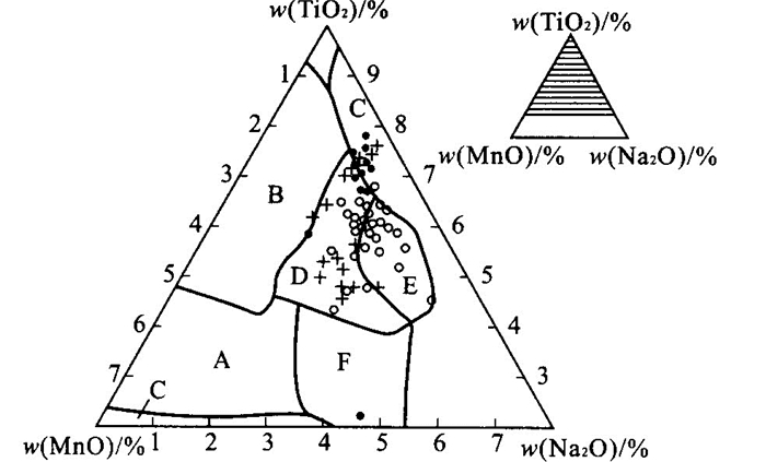
Junggar basin basement can be divided into three areas (west, north and south) by data from drilling and aeromagnetism. These areas contain all sorts of chemical components and type names of pyroxene. While these pyroxene chemical components are shown to be quite different by the volcanic rock alkalinity, its evolution trend, formation tectonic environments and its tectonic environment evolution history. This proves that Junggar basin basement is composed of amalgamation of the growing continent of the southeastern margin of the Kazakhstan plate, the southwestern margin of the Siberia plate and the northern margin of the Tarim plate. During the amalgamation, the western and northern parts joined together earlierly, and formed the continent by the uplift in the early Hercynian orogeny in the late Early Carboniferous. While the southern part was relatively late in the continent formation and Late Carboniferous plate movement caused the combination of the southern and the northwestern continents thus forming the complete Junggar basin fold basement.
Junggar basin basement can be divided into three areas (west, north and south) by data from drilling and aeromagnetism. These areas contain all sorts of chemical components and type names of pyroxene. While these pyroxene chemical components are shown to be quite different by the volcanic rock alkalinity, its evolution trend, formation tectonic environments and its tectonic environment evolution history. This proves that Junggar basin basement is composed of amalgamation of the growing continent of the southeastern margin of the Kazakhstan plate, the southwestern margin of the Siberia plate and the northern margin of the Tarim plate. During the amalgamation, the western and northern parts joined together earlierly, and formed the continent by the uplift in the early Hercynian orogeny in the late Early Carboniferous. While the southern part was relatively late in the continent formation and Late Carboniferous plate movement caused the combination of the southern and the northwestern continents thus forming the complete Junggar basin fold basement.
2002, 27(1): 19-24.
Abstract:
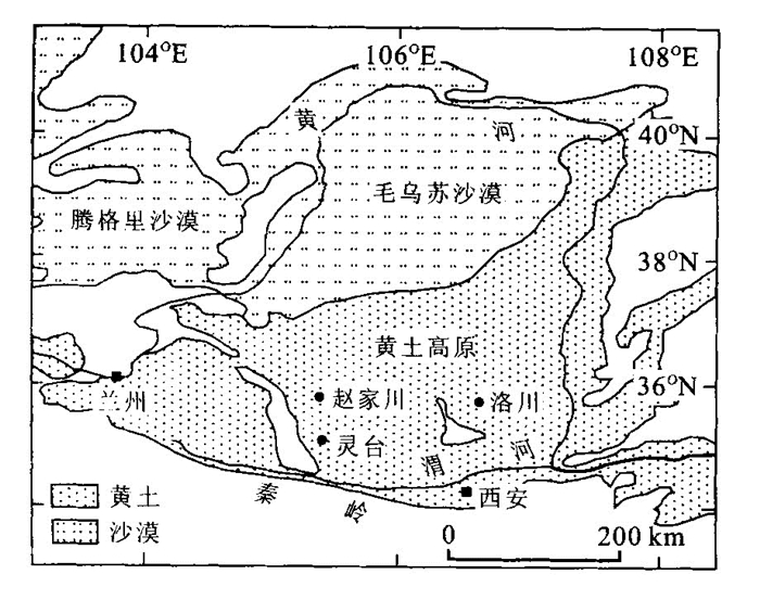
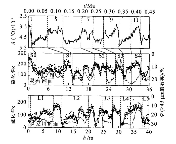
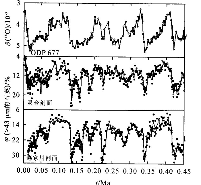
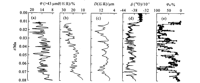
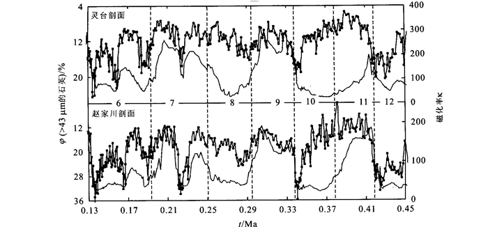
Study on the high resolution loess record from the Chinese loess plateau is the main approach to reveal the past climatic change and variability. The undisturbed and continuous accumulation of the loess deposits has provided an opportunity to develop complete and high resolution records of terrestrial climate changes over multiple glacial interglacial cycles during the past 7 million years. In the present paper, Lingtai and Zhaojiachuan profiles from the central loess plateau were studied down to loess unit L5, formed during the last four glacial interglacial cycles. Quartz grains were extracted by chemical methods for grain size analysis, and the grain size data indicate that coarse quartz volume fraction could be considered as the reliable proxy of the East Asian winter monsoon. Changes in the content of coarse quartz volume fraction have documented the high frequency variability of winter monsoon during the last four glacial interglacial cycles and can be well correlated to the marine δ(18O) record, whereas the content of the coarse quartz volume fraction variation shows a different variability during every glacial period that may indicate the various underlying conditions and non linear responses during the last four glaciations. It is worthwhile to note that in some cases the variation of coarse quartz volume fraction exhibits a disagreement with both magnetic susceptibility variation and the marine oxygen isotope curves. Such disparity of the past climate changes revealed by different proxy records is very important for understanding the global significance of Chinese loess and thus requires further investigation.
Study on the high resolution loess record from the Chinese loess plateau is the main approach to reveal the past climatic change and variability. The undisturbed and continuous accumulation of the loess deposits has provided an opportunity to develop complete and high resolution records of terrestrial climate changes over multiple glacial interglacial cycles during the past 7 million years. In the present paper, Lingtai and Zhaojiachuan profiles from the central loess plateau were studied down to loess unit L5, formed during the last four glacial interglacial cycles. Quartz grains were extracted by chemical methods for grain size analysis, and the grain size data indicate that coarse quartz volume fraction could be considered as the reliable proxy of the East Asian winter monsoon. Changes in the content of coarse quartz volume fraction have documented the high frequency variability of winter monsoon during the last four glacial interglacial cycles and can be well correlated to the marine δ(18O) record, whereas the content of the coarse quartz volume fraction variation shows a different variability during every glacial period that may indicate the various underlying conditions and non linear responses during the last four glaciations. It is worthwhile to note that in some cases the variation of coarse quartz volume fraction exhibits a disagreement with both magnetic susceptibility variation and the marine oxygen isotope curves. Such disparity of the past climate changes revealed by different proxy records is very important for understanding the global significance of Chinese loess and thus requires further investigation.
2002, 27(1): 25-29.
Abstract:
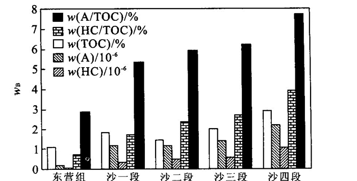
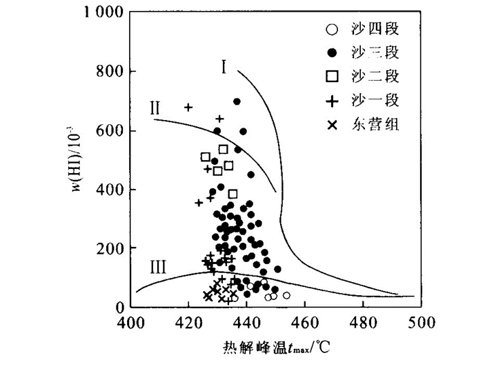
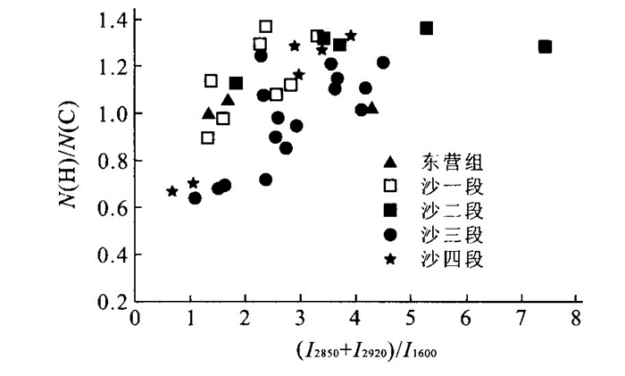
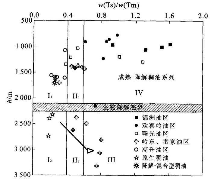
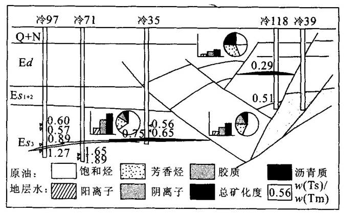
The discovery and study of immature oils is one of the most important progresses in oil and gas geochemistry in recent years. The generation hydrocarbons have been studied based on source rock characters. The oil is divided into six types, namely immature to lower mature, bio degraded heavy oil, immature undegraded heavy oil, lower mature bio degraded heavy oil, lower mature oil, normal oil and mature bio degraded heavy oil. On the basis of above, it was researched about immature oils distribution character. It shows that the immature oils distribution is controlled by depth, structural belt of oil generating depression and fault conducting ability.
The discovery and study of immature oils is one of the most important progresses in oil and gas geochemistry in recent years. The generation hydrocarbons have been studied based on source rock characters. The oil is divided into six types, namely immature to lower mature, bio degraded heavy oil, immature undegraded heavy oil, lower mature bio degraded heavy oil, lower mature oil, normal oil and mature bio degraded heavy oil. On the basis of above, it was researched about immature oils distribution character. It shows that the immature oils distribution is controlled by depth, structural belt of oil generating depression and fault conducting ability.
2002, 27(1): 30-34.
Abstract:
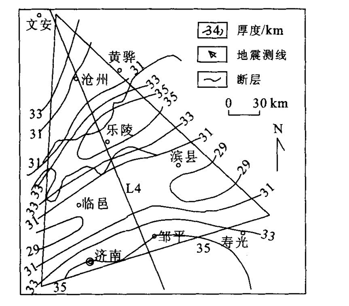
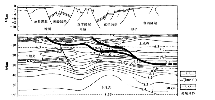
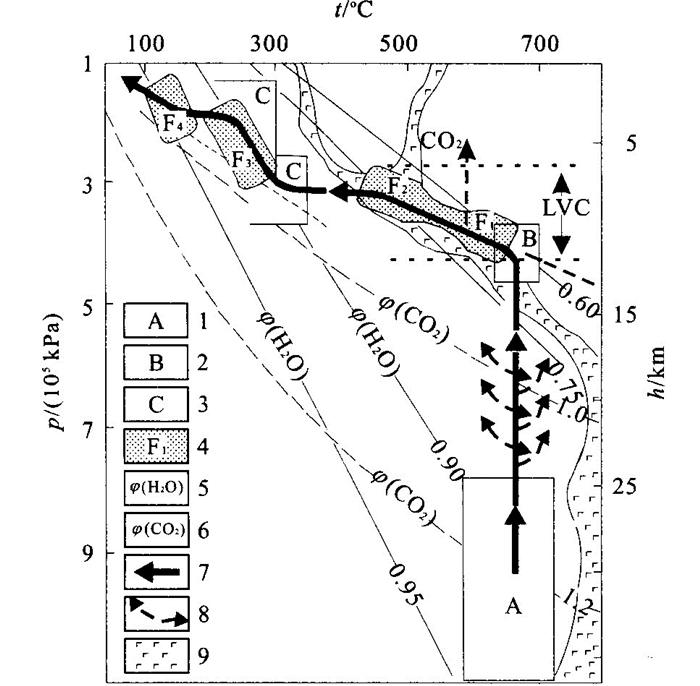
A synthetic analysis of deep seismic prospecting data and abiogenic gas distribution preliminarily reveals that superplastic rheological mechanism affects significantly the flow deformation of rocks and adjustment of deep structures of the earth crust in the Jiyang depression. Mantle substance upwelling and flow deformation of rocks in middle and lower crusts, especially in low velocity body, along with stretching breach within the surface crust, restrict the development of the gas bearing structures according to a knockdown style of brittle split in surface crust and flow deformation in depth. Magma function was obstructed by tenacity layer of the crust, and assimilated lithospheric substance through anatexis and transformed the layer nature by virtue of emplacement in the crust. In the layer containing low velocity body, metamorphism and weakness of crust rocks have been promoted as the fluid including gathered CO 2. Deep bedding fault, structural dismantling and expansion of fault root among whole crust arrangement constitute beneficial structural factors for the abiogenic gas accumulation and storage in the study area.
A synthetic analysis of deep seismic prospecting data and abiogenic gas distribution preliminarily reveals that superplastic rheological mechanism affects significantly the flow deformation of rocks and adjustment of deep structures of the earth crust in the Jiyang depression. Mantle substance upwelling and flow deformation of rocks in middle and lower crusts, especially in low velocity body, along with stretching breach within the surface crust, restrict the development of the gas bearing structures according to a knockdown style of brittle split in surface crust and flow deformation in depth. Magma function was obstructed by tenacity layer of the crust, and assimilated lithospheric substance through anatexis and transformed the layer nature by virtue of emplacement in the crust. In the layer containing low velocity body, metamorphism and weakness of crust rocks have been promoted as the fluid including gathered CO 2. Deep bedding fault, structural dismantling and expansion of fault root among whole crust arrangement constitute beneficial structural factors for the abiogenic gas accumulation and storage in the study area.
2002, 27(1): 35-39.
Abstract:
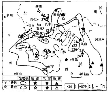
The genesis of the Carlin-type gold deposits in the Youjiang basin, South China, has a close relationship with the evolution of the ancient oil reservoirs. Both Raman spectroscopy analysis of the fluid inclusions and gas chromatogram and mass spectrum analysis of the extractives from the ore indicate occurrences of abundant organic compounds. The gold deposits also have a consistent spatial distribution with the ancient oil reservoirs. Both of them occur in the core or on the flank of the Permian reef. According to the analyzed history of the Youjiang basin, the original fluid was formed during the rifting and early depression stage (> 172 Ma) of the basin. In the following approximately 40 Ma(172-130 Ma), there exists no strong tectonic movement in the Youjiang basin. It is available for the original fluid to migrate into the core or flank of the carbonate platform and other similar reservoirs. The original fluid turned gradually into ore-forming fluid during the migration. This process is also the migration of the hydrocarbon from the matured source rocks. The gold deposits were formed and the ancient oil reservoir was destroyed in Yenshan tectonic movement. It is the destroying of the ancient oil reservoir that caused the accumulation of the ore-forming elements to form the ore deposits. Based on the above facts, this paper proposed that the gold deposits and the ancient oil pools were products of the same fluid in its different stages of evolution.
The genesis of the Carlin-type gold deposits in the Youjiang basin, South China, has a close relationship with the evolution of the ancient oil reservoirs. Both Raman spectroscopy analysis of the fluid inclusions and gas chromatogram and mass spectrum analysis of the extractives from the ore indicate occurrences of abundant organic compounds. The gold deposits also have a consistent spatial distribution with the ancient oil reservoirs. Both of them occur in the core or on the flank of the Permian reef. According to the analyzed history of the Youjiang basin, the original fluid was formed during the rifting and early depression stage (> 172 Ma) of the basin. In the following approximately 40 Ma(172-130 Ma), there exists no strong tectonic movement in the Youjiang basin. It is available for the original fluid to migrate into the core or flank of the carbonate platform and other similar reservoirs. The original fluid turned gradually into ore-forming fluid during the migration. This process is also the migration of the hydrocarbon from the matured source rocks. The gold deposits were formed and the ancient oil reservoir was destroyed in Yenshan tectonic movement. It is the destroying of the ancient oil reservoir that caused the accumulation of the ore-forming elements to form the ore deposits. Based on the above facts, this paper proposed that the gold deposits and the ancient oil pools were products of the same fluid in its different stages of evolution.
2002, 27(1): 41-45.
Abstract:
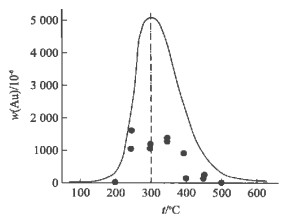
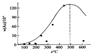
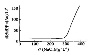
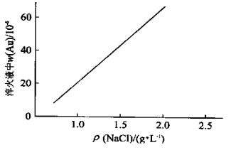
Simulate experiments of gold precipitated by lowering temperature and changing salt-content are designed by simplifying experimental system and separating influential factors in order to study two main mechanisms of gold precipitated by fluid-mixing function. The study shows first of all that the Au content in solution is lower with the falling temperature of solution, with a kind of complex functional relationship between them, and 300 ℃ as the most significant temperature in geology for gold mineralization.Second, lowering the salt content of the Au-fluid reduces the content of complex foundation, and lead to the gold precipitating. Third, the alkalic metasomatism in the rock is beneficial to gold mineralization.
Simulate experiments of gold precipitated by lowering temperature and changing salt-content are designed by simplifying experimental system and separating influential factors in order to study two main mechanisms of gold precipitated by fluid-mixing function. The study shows first of all that the Au content in solution is lower with the falling temperature of solution, with a kind of complex functional relationship between them, and 300 ℃ as the most significant temperature in geology for gold mineralization.Second, lowering the salt content of the Au-fluid reduces the content of complex foundation, and lead to the gold precipitating. Third, the alkalic metasomatism in the rock is beneficial to gold mineralization.
2002, 27(1): 46-49.
Abstract:
The application of thermochromic materials is commonly restricted by surroundings, strong acid, strong base, impurity stain and other factors. The processing conditions of microencapsulation using thermochromic materials as the core were investigated. The thermochromic materials are composed of indicator and the compounds which change pH when heated. Also, the formation mechanism is discussed. The microencapsulation will promote the application of thermochromic materials.
The application of thermochromic materials is commonly restricted by surroundings, strong acid, strong base, impurity stain and other factors. The processing conditions of microencapsulation using thermochromic materials as the core were investigated. The thermochromic materials are composed of indicator and the compounds which change pH when heated. Also, the formation mechanism is discussed. The microencapsulation will promote the application of thermochromic materials.
2002, 27(1): 50-54.
Abstract:
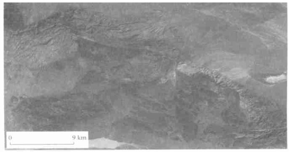
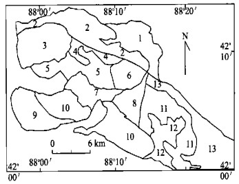
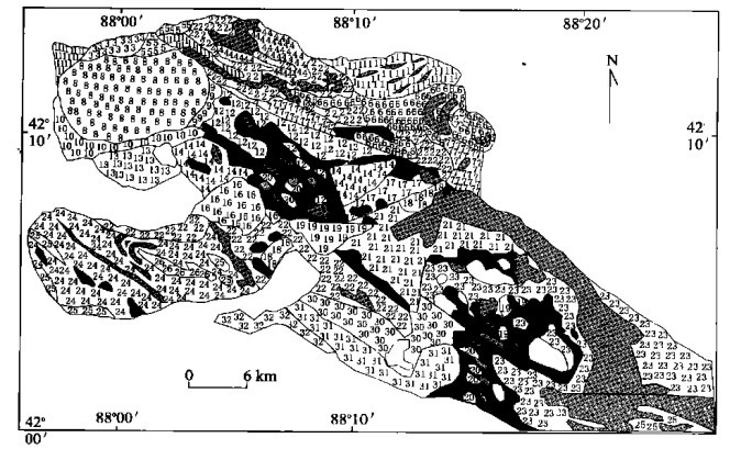
It is very difficult to interpret remote sensing images in an orogenic belt with complex strata combination and strongly deformed structure. This paper proposes a novel wavelet frame packet analysis approach for multivariable image segmentation. The approach effectively combines both the texture and color information. It has produced good performance in the extraction of geological information in the deformable area in Tonghuashan-Liuhuangshan in the eastern part of Tianshan mountains.
It is very difficult to interpret remote sensing images in an orogenic belt with complex strata combination and strongly deformed structure. This paper proposes a novel wavelet frame packet analysis approach for multivariable image segmentation. The approach effectively combines both the texture and color information. It has produced good performance in the extraction of geological information in the deformable area in Tonghuashan-Liuhuangshan in the eastern part of Tianshan mountains.
2002, 27(1): 55-58.
Abstract:
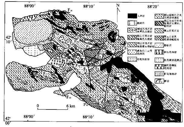
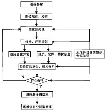
This paper presents the principle and application of automatic interpretation of remote-sensing spatial information based on GIS in mineral resources prognosis of synthetic information. It studied the remote-sensing spatial information integrating method, which includes remote-sensing data processing, data transformation, linear and circular structure extraction from remote-sensing images, and automatic recognition and connection of gravitation, magnetic and remote-sensing information. In addition, it illustrates an example of this method application.
This paper presents the principle and application of automatic interpretation of remote-sensing spatial information based on GIS in mineral resources prognosis of synthetic information. It studied the remote-sensing spatial information integrating method, which includes remote-sensing data processing, data transformation, linear and circular structure extraction from remote-sensing images, and automatic recognition and connection of gravitation, magnetic and remote-sensing information. In addition, it illustrates an example of this method application.
2002, 27(1): 59-62.
Abstract:
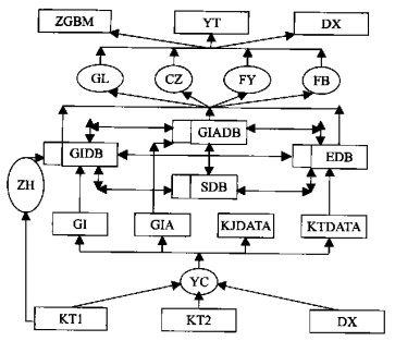
On the basis of analysis of graph and image's standardization in petroleum exploration, feasibility has been discussed to develop the normalized graph and image Database system of petroleum exploration (GIDBS) using GIS technology, and base designing of development of GIDBS is provided. First, an introduction is made of the normalization of graph and image(G&I)of petroleum exploration, and regulations are proposed for classifying, layering, and coding. Second, according to the analysis of data flow, multi-layer system architecture with C/S mode is put forward. Third, the main function of GIDBS, including map-making, browsing and inquiring, input/output, transforming and interoperability, analysis, distribution and so on, will be practiced using GIS technologies such as map-making, guide-space, and space analysis. Last, two key problems are inquired to concern the realization of GIDBS: one is the degree of normalization of G&I, which is seriously related to usability of GIDBS; another is interoperability between different graph databases with different running platforms.
On the basis of analysis of graph and image's standardization in petroleum exploration, feasibility has been discussed to develop the normalized graph and image Database system of petroleum exploration (GIDBS) using GIS technology, and base designing of development of GIDBS is provided. First, an introduction is made of the normalization of graph and image(G&I)of petroleum exploration, and regulations are proposed for classifying, layering, and coding. Second, according to the analysis of data flow, multi-layer system architecture with C/S mode is put forward. Third, the main function of GIDBS, including map-making, browsing and inquiring, input/output, transforming and interoperability, analysis, distribution and so on, will be practiced using GIS technologies such as map-making, guide-space, and space analysis. Last, two key problems are inquired to concern the realization of GIDBS: one is the degree of normalization of G&I, which is seriously related to usability of GIDBS; another is interoperability between different graph databases with different running platforms.
2002, 27(1): 63-66.
Abstract:
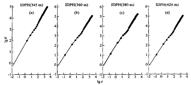
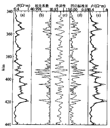
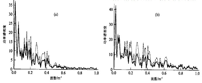
Accurate measurement of actual geophysical properties, with well logging curves, for thin layers and thin alternate layersisof greatimportance to the identification and interpretation of oil beds, and especially to the processing and interpretation of geophysical well logging data from the continental oil beds. In this paper, the authors present a definition of well logging measurement. The fractal theory shows an exponential relationship thatis present between measure and scale. Thisexponential relationship can be used to obtain or reconstruct well logging curves, reflecting the local variation structure of the well logging curves and amending some errors in such surveying measurements as stratigraphic sliding average caused by the well logger. This method has been tested with the intermediate- and deep-induction electrical-conductivity well-logging curves obtained from Ocean Drilling Project(ODP), Leg 127, 979C hole. The comparison between the original and corrected well logging curves and their corresponding power spectral curves indicates that the corrected well logging curves are more effective than the original well logging curves in the resolution enhancement, because the corrected well logging curveseliminate partof the interferences from their neighboring strata and contain more frequency spectral components. Therefore, the fractal corrected method can be employed to increase the resolution of the well logging curves to detect thin stratigrahic layers.
Accurate measurement of actual geophysical properties, with well logging curves, for thin layers and thin alternate layersisof greatimportance to the identification and interpretation of oil beds, and especially to the processing and interpretation of geophysical well logging data from the continental oil beds. In this paper, the authors present a definition of well logging measurement. The fractal theory shows an exponential relationship thatis present between measure and scale. Thisexponential relationship can be used to obtain or reconstruct well logging curves, reflecting the local variation structure of the well logging curves and amending some errors in such surveying measurements as stratigraphic sliding average caused by the well logger. This method has been tested with the intermediate- and deep-induction electrical-conductivity well-logging curves obtained from Ocean Drilling Project(ODP), Leg 127, 979C hole. The comparison between the original and corrected well logging curves and their corresponding power spectral curves indicates that the corrected well logging curves are more effective than the original well logging curves in the resolution enhancement, because the corrected well logging curveseliminate partof the interferences from their neighboring strata and contain more frequency spectral components. Therefore, the fractal corrected method can be employed to increase the resolution of the well logging curves to detect thin stratigrahic layers.
2002, 27(1): 67-71.
Abstract:
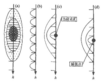
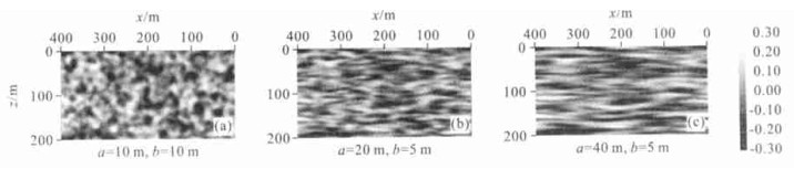
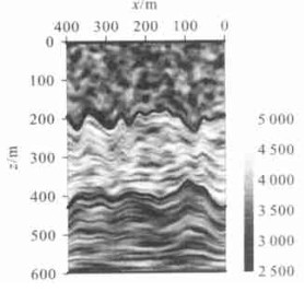
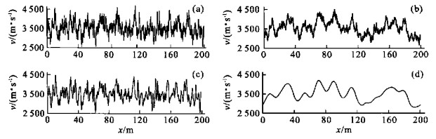
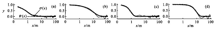
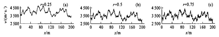
We discussed some basic concept of random media, and discussed the characteristics of random media models with exponential and Gaussian elliptic autocorrelation functions. Meanwhile by integrating the characteristics of random media models with exponential and Gaussian elliptic autocorrelation functions, we put forward the concept of roughness factor, and hereafter the concept of intermixed random medium model, which may describe the realistic media more agilely and precisely. By selecting the autocorrelation length a of horizontal direction, b of vertical direction and r of roughness factor, we may generate diversified intermixed random media models. The results of simulations show that the intermixed random media model can describe the realistic media more agilely, with strong adaptability and convenience and agile use, and thus can simulate details of the reservoir efficiently.
We discussed some basic concept of random media, and discussed the characteristics of random media models with exponential and Gaussian elliptic autocorrelation functions. Meanwhile by integrating the characteristics of random media models with exponential and Gaussian elliptic autocorrelation functions, we put forward the concept of roughness factor, and hereafter the concept of intermixed random medium model, which may describe the realistic media more agilely and precisely. By selecting the autocorrelation length a of horizontal direction, b of vertical direction and r of roughness factor, we may generate diversified intermixed random media models. The results of simulations show that the intermixed random media model can describe the realistic media more agilely, with strong adaptability and convenience and agile use, and thus can simulate details of the reservoir efficiently.
2002, 27(1): 72-79.
Abstract:
Post industry is a developing epoch regarded as "intellectual economy" or "new economy". In these years, natural resources, common (general) labour resources and mineral resources' basic status in national economy and social development has gradually been replaced by acquired resources, such as: information property right, marketing network, information and innovative environment and new "recognized intellect" for persons with innovative ability. However, the distribution and metallogeny of mineral resources possess certain global uniformity and regional exceptionality as well as inhomogeneity of exploring extent of different countries to mineral resources, especially to the difference of mining activities and other industry, so if we can, in term of different developing conditions of different countries, manage the 21st century's mining industry to incline to developing states of "post industry", trying to make it realize the survival of the fittest and sustainable development - obviously, it is also an important project expecting to be discussed. In this paper, on the basis of the general discussion for developing state of the 21st century's mining industry, the characteristics of mining activities and its natural property, the author proposes a modeling of geological exploration for sustainable development of mining industry and decision making system for mining activity, as well as the new "recognized intellect" for sustainable development of very shortage copper deposits.
Post industry is a developing epoch regarded as "intellectual economy" or "new economy". In these years, natural resources, common (general) labour resources and mineral resources' basic status in national economy and social development has gradually been replaced by acquired resources, such as: information property right, marketing network, information and innovative environment and new "recognized intellect" for persons with innovative ability. However, the distribution and metallogeny of mineral resources possess certain global uniformity and regional exceptionality as well as inhomogeneity of exploring extent of different countries to mineral resources, especially to the difference of mining activities and other industry, so if we can, in term of different developing conditions of different countries, manage the 21st century's mining industry to incline to developing states of "post industry", trying to make it realize the survival of the fittest and sustainable development - obviously, it is also an important project expecting to be discussed. In this paper, on the basis of the general discussion for developing state of the 21st century's mining industry, the characteristics of mining activities and its natural property, the author proposes a modeling of geological exploration for sustainable development of mining industry and decision making system for mining activity, as well as the new "recognized intellect" for sustainable development of very shortage copper deposits.
2002, 27(1): 81-84.
Abstract:
Mining right, derived from the proprietorship of mineral resources is the right that is implemented by others and it is obtained by a repayment. Therefore, the dealing of the mining right in the market for profit should be considered rational. The exchange value of the mining right is composed of the utilization value of the mineral resources and the value of the geological exploitation results. The former is called the graded mine rent and the latter absolute mine rent and they are the excess profit obtained by the equation of existing income value. While the latter is usually derived from rational labour consumption or cost effectiveness. Finally different economic realization methods and operations are suggested for the two rents according to the manners of the mining right motion.
Mining right, derived from the proprietorship of mineral resources is the right that is implemented by others and it is obtained by a repayment. Therefore, the dealing of the mining right in the market for profit should be considered rational. The exchange value of the mining right is composed of the utilization value of the mineral resources and the value of the geological exploitation results. The former is called the graded mine rent and the latter absolute mine rent and they are the excess profit obtained by the equation of existing income value. While the latter is usually derived from rational labour consumption or cost effectiveness. Finally different economic realization methods and operations are suggested for the two rents according to the manners of the mining right motion.
2002, 27(1): 85-89.
Abstract:
This paper, from the findings of both mineral resources uphold power (MRUP) and mineral resources competitive power (MRCP), develops a new conception of mineral resources sustainable power (MRSP) integrating quantity, quality and time-space dimension but emphasizing development, intertemporate fairness and coordination on the basis of sustainable development and system theory. Moreover, it discusses the system composed of such factors as resources, economy, society, environment and intelligence from system science. Based on sustaining functions of development power and coordination power of MRSP system, MRSP system is also constructed with focus method.
This paper, from the findings of both mineral resources uphold power (MRUP) and mineral resources competitive power (MRCP), develops a new conception of mineral resources sustainable power (MRSP) integrating quantity, quality and time-space dimension but emphasizing development, intertemporate fairness and coordination on the basis of sustainable development and system theory. Moreover, it discusses the system composed of such factors as resources, economy, society, environment and intelligence from system science. Based on sustaining functions of development power and coordination power of MRSP system, MRSP system is also constructed with focus method.

2002, 27(1): 90-96.
Abstract:
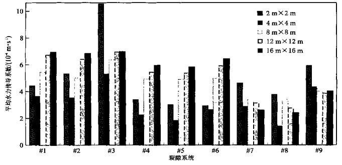
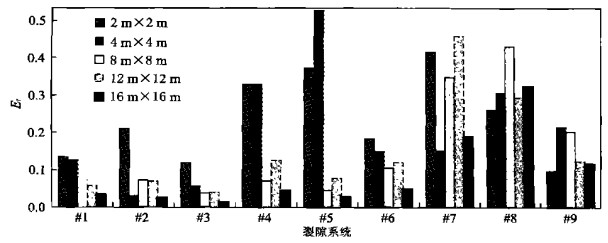
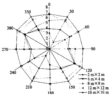
The continuum approach in fluid flow modeling can generally be applied to porous geological media, but has limited applicability for fractured rocks. With the presence of a complex fracture network pattern and the fluid flow restricted mainly to the fractures, the porous media assumption does not adequately describe the flow behavior in the fractured rocks. A discrete fracture flow model has the capability not only in capturing inhomogeneity and anisotropy, but also in estimating representative elementary volume (REV) and determining hydraulic conductivity tensor for fractured rocks. In this paper, the following sub topics were discussed: (a) general discrete fracture fluid flow modeling for saturated fractured geologic media; (b) determinations of REV and hydraulic conductivity tensor for fractured rocks using a discrete fracture network fluid flow model; (c) investigations of fracture orientation effect on the hydraulic conductivity and REV using a discrete fracture network fluid flow model, and (d) the ways to treat major fractures vs. minor fractures in the 2D and 3D discrete fracture fluid flow models. The results from this investigation indicate that a discrete fracture flow model could be used to evaluate the hydraulic properties at different scales. In addition, the orientation of fractures plays an important role in determining the hydraulic behaviors in fractured rocks. Furthermore, various conceptual fluid flow models are presented to reflect the different flow features of both minor and major fractures identified in fractured rock masses.
The continuum approach in fluid flow modeling can generally be applied to porous geological media, but has limited applicability for fractured rocks. With the presence of a complex fracture network pattern and the fluid flow restricted mainly to the fractures, the porous media assumption does not adequately describe the flow behavior in the fractured rocks. A discrete fracture flow model has the capability not only in capturing inhomogeneity and anisotropy, but also in estimating representative elementary volume (REV) and determining hydraulic conductivity tensor for fractured rocks. In this paper, the following sub topics were discussed: (a) general discrete fracture fluid flow modeling for saturated fractured geologic media; (b) determinations of REV and hydraulic conductivity tensor for fractured rocks using a discrete fracture network fluid flow model; (c) investigations of fracture orientation effect on the hydraulic conductivity and REV using a discrete fracture network fluid flow model, and (d) the ways to treat major fractures vs. minor fractures in the 2D and 3D discrete fracture fluid flow models. The results from this investigation indicate that a discrete fracture flow model could be used to evaluate the hydraulic properties at different scales. In addition, the orientation of fractures plays an important role in determining the hydraulic behaviors in fractured rocks. Furthermore, various conceptual fluid flow models are presented to reflect the different flow features of both minor and major fractures identified in fractured rock masses.
2002, 27(1): 97-104.
Abstract:
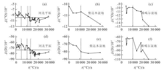
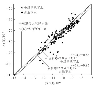
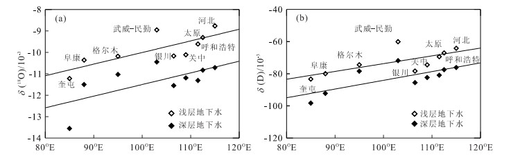
The underground water compositions of δ(D), δ(18O), 3H and 14C are distinct in shallow and deep Quaternary aquifers in northern China and reflect differences in average paleoclimatic conditions between the Holocene and the last glacial period of Pleistocene. The recharge of the groundwater in deep confined aquifer during the last glacial period caused δ(D) and δ(18O) to deplete by 4×10⁻³-16×10-3 and 1×10⁻³ -2×10⁻³ when compared to shallow aquifer recharged in Holocene, which suggests that annual mean temperature was lower in the last glacial period than that in the Holocene. While the similarity of the continental gradient of δ(D) and δ(18O) found in old groundwater to that in Holocene suggests that atmospheric circulation may not have gone substantial changes over northern China for the past 30 000 years even though the temperature had changed. The fact that groundwater isotopic stratification implies three different recharge mechanisms and influence of modern hydrological circulation is very important for understanding the continental hydrological circulation and sustaining development for groundwater resources.
The underground water compositions of δ(D), δ(18O), 3H and 14C are distinct in shallow and deep Quaternary aquifers in northern China and reflect differences in average paleoclimatic conditions between the Holocene and the last glacial period of Pleistocene. The recharge of the groundwater in deep confined aquifer during the last glacial period caused δ(D) and δ(18O) to deplete by 4×10⁻³-16×10-3 and 1×10⁻³ -2×10⁻³ when compared to shallow aquifer recharged in Holocene, which suggests that annual mean temperature was lower in the last glacial period than that in the Holocene. While the similarity of the continental gradient of δ(D) and δ(18O) found in old groundwater to that in Holocene suggests that atmospheric circulation may not have gone substantial changes over northern China for the past 30 000 years even though the temperature had changed. The fact that groundwater isotopic stratification implies three different recharge mechanisms and influence of modern hydrological circulation is very important for understanding the continental hydrological circulation and sustaining development for groundwater resources.
2002, 27(1): 105-109.
Abstract:
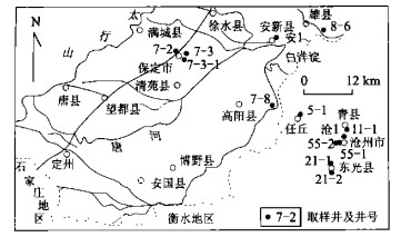
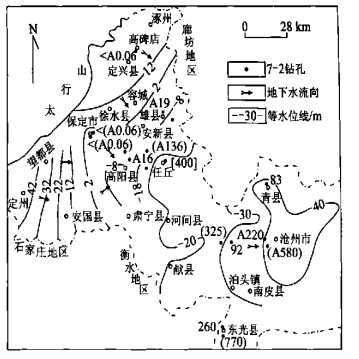
For the study of the groundwater age in the deep formation of Quaternary sediments of Hebei plain, the N(36Cl)/N(Cl) ratio of groundwater samples were determined by tandem accelerator mass spectrometry. The chlorine 36 ages were compared with hydrodynamic ages. The groundwater of the third and fourth aquifers of Quaternary sediments in the Baoding district of Hebei plain was found young, that of the third aquifer in the east of Baoding district and the west of Cangzhou district being less than 50 thousand years and that of the fourth aquifer, perhaps more than 100 thousand years. While the groundwater age of the third aquifer in Cangzhou city and Qingxian county was 80-90 thousand years and that in Dongguang county was 260 thousand years, that of the fourth aquifer in Cangzhou city was 330 thousand years and that in Dongguang county was 770 thousand years.
For the study of the groundwater age in the deep formation of Quaternary sediments of Hebei plain, the N(36Cl)/N(Cl) ratio of groundwater samples were determined by tandem accelerator mass spectrometry. The chlorine 36 ages were compared with hydrodynamic ages. The groundwater of the third and fourth aquifers of Quaternary sediments in the Baoding district of Hebei plain was found young, that of the third aquifer in the east of Baoding district and the west of Cangzhou district being less than 50 thousand years and that of the fourth aquifer, perhaps more than 100 thousand years. While the groundwater age of the third aquifer in Cangzhou city and Qingxian county was 80-90 thousand years and that in Dongguang county was 260 thousand years, that of the fourth aquifer in Cangzhou city was 330 thousand years and that in Dongguang county was 770 thousand years.
2002, 27(1): 110-114.
Abstract:
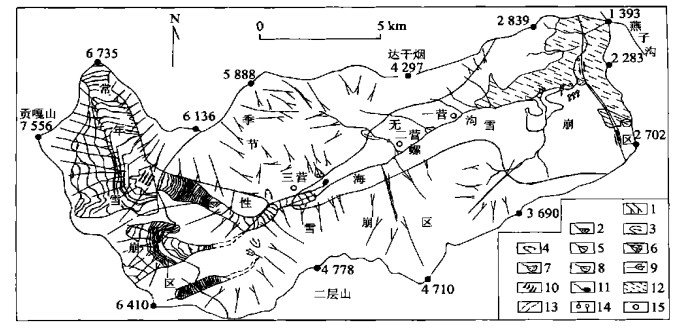
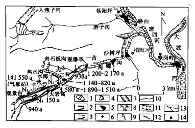
In Hailuogou, a famous landscape, there is a close relationship between the ecological phenomenon and the evolvement of geological environment. Many natural hazards or unnatural disasters happened because of the rapid growth of population in this region. The authors carefully evaluated the geological environment, and analyzed the particular geology characters in this region. As a result, a series of prevention measures of disasters are brought forward for the further development of the region. According to the field investigation, the main geological problems included snow avalanche, glacier avalanche, frost bursting, creeping slip of rock and soil, falling, landslide, debris flow, soil erosion and earthquake, and the reasons for these problems can be concluded as following: (1) the upward risen of the neo tectonic movement is very strong. (2) the geological structure system is quite complex. (3) the effect of glacierization is rather clear. (4) the heavy precipitated water often happens. (5) human activities are very frequent. At last, for protection of the geological environment in the area, the authors raise three pieces of advice. First, evaluate the stability of the slope in section 1.Second, control of falling and debris flows and exploit thermal springs in section 2. Last, plan a channel for the drainage of debris flow in section 3.
In Hailuogou, a famous landscape, there is a close relationship between the ecological phenomenon and the evolvement of geological environment. Many natural hazards or unnatural disasters happened because of the rapid growth of population in this region. The authors carefully evaluated the geological environment, and analyzed the particular geology characters in this region. As a result, a series of prevention measures of disasters are brought forward for the further development of the region. According to the field investigation, the main geological problems included snow avalanche, glacier avalanche, frost bursting, creeping slip of rock and soil, falling, landslide, debris flow, soil erosion and earthquake, and the reasons for these problems can be concluded as following: (1) the upward risen of the neo tectonic movement is very strong. (2) the geological structure system is quite complex. (3) the effect of glacierization is rather clear. (4) the heavy precipitated water often happens. (5) human activities are very frequent. At last, for protection of the geological environment in the area, the authors raise three pieces of advice. First, evaluate the stability of the slope in section 1.Second, control of falling and debris flows and exploit thermal springs in section 2. Last, plan a channel for the drainage of debris flow in section 3.
2002, 27(1): 115-119.
Abstract:
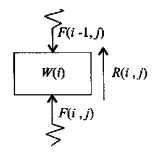
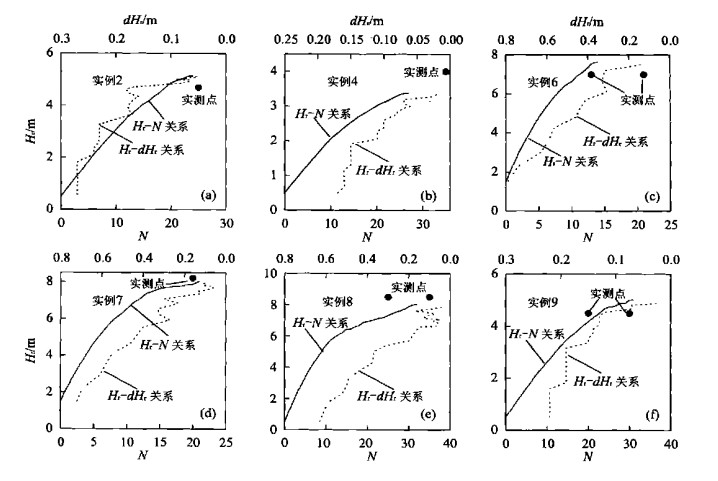
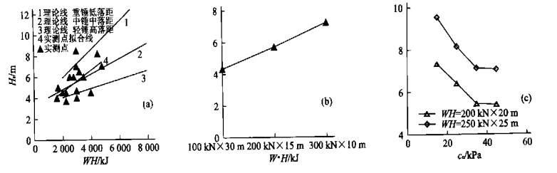
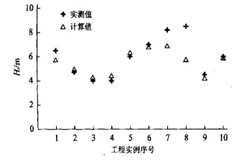
Dynamic replacement has gained wide application, but its design is highly empirical. There is no way to estimate properly the displacement depth. In this event, this paper draws its attention on this subject, proposes a one dimensional wave equation model and its solution method for the replacement depth estimation, and gives the values of the parameters in this model for reference. Case studies showed this model is satisfactory. Thereafter, the replacement process has been simulated and a simplified formula for the replacement depth estimation is presented.
Dynamic replacement has gained wide application, but its design is highly empirical. There is no way to estimate properly the displacement depth. In this event, this paper draws its attention on this subject, proposes a one dimensional wave equation model and its solution method for the replacement depth estimation, and gives the values of the parameters in this model for reference. Case studies showed this model is satisfactory. Thereafter, the replacement process has been simulated and a simplified formula for the replacement depth estimation is presented.
2002, 27(1): 120-126.
Abstract:
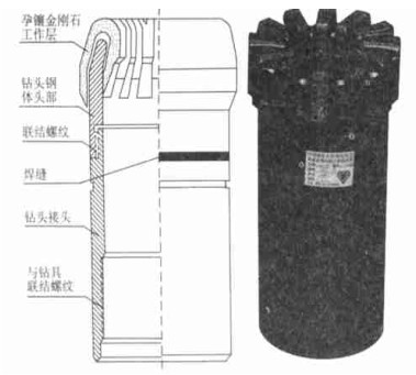
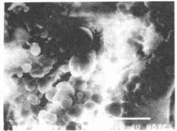
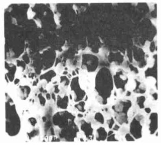
This bit is used for coring in hard rocks.Previously, the bits used for coring in Henan oilfield are column PDC or triangle PDC bits and conventionally heat impregmented diamond bits, which are low in coring efficiency and drilling speed and high in cost.While the average drilling speed has increased from 4.20 m to 7.62 m in one drilling and the average coring rotation has increased from 0.21 m per hour to 0.84 m per hour when the low temperature eltectroplated diamond bits have been used in recent two years. The manufacturing technique of this kind of diamond bits with the temperature changed from over 1 000 ℃ in the conventional one to the constant room temperature has greatly prevented the bits from heat damage and enhanced the coring rotation speed with the use of large grained diamonds with high strength.
This bit is used for coring in hard rocks.Previously, the bits used for coring in Henan oilfield are column PDC or triangle PDC bits and conventionally heat impregmented diamond bits, which are low in coring efficiency and drilling speed and high in cost.While the average drilling speed has increased from 4.20 m to 7.62 m in one drilling and the average coring rotation has increased from 0.21 m per hour to 0.84 m per hour when the low temperature eltectroplated diamond bits have been used in recent two years. The manufacturing technique of this kind of diamond bits with the temperature changed from over 1 000 ℃ in the conventional one to the constant room temperature has greatly prevented the bits from heat damage and enhanced the coring rotation speed with the use of large grained diamonds with high strength.