2002 Vol. 27, No. 6
Display Method:
2002, 27(6): 659-665.
 PDF 463KB
Abstract:
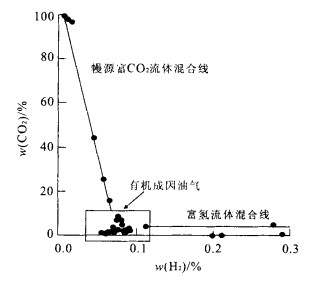
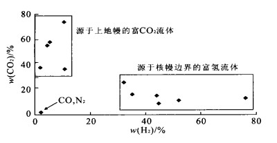
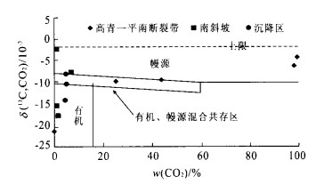
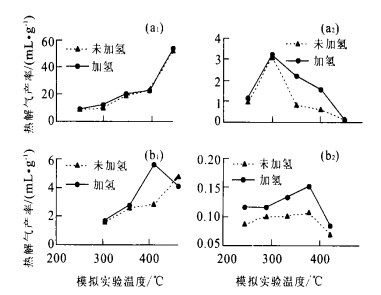
This paper focuses on geochemical features of deep fluids (mainly mantle-derived fluid) and their effect on oil/gas reservoirs formation in Dongiyng sag, Jiyang depression and Central Tarim basin, by using isotopic geochemistry, organic geochemistry and thermodynamics. It is found that both CO2- (H2O+CO2) and H- (H2O+CH4+H2) rich fluids from the mantle are injected into Dongying sag and CO2-rich fluid in Central Tarim basin. The quantitative study of heat transformation of deep fluid ascendance shows that the mantle is an effective heat carrier. The evidence of thermal anomalies in Dongying sag and Central Tarim basin proves the existence of heat effect of deep fluids. Hydrocarbon generation from kerogen degragation not only needs heat but also actually requires hydrogen. It is known that mantle-derived, hydrogen-rich fluid may increase hydrocarbon production when the fluid meets source rocks in basins. Experimental hydrogenation simulation shows that hydrogen addition increases the production greatly. For sapropelic kerogen, the effect of hydrogenation becomes evident after fastigium of hydrocarbon generation and the production can increase up to 147%. While for humic kerogen, hydrocarbon production by hydrogenation can be increased at every stage of thermal evolution. It is found that deep fluids increase production rate of the source rocks in Dongying sag and Central Tarim basin. Hence it can be concluded that the mantle-derived fluids have great influence on hydrocarbon generation from source rocks in both energy and substance supply.
This paper focuses on geochemical features of deep fluids (mainly mantle-derived fluid) and their effect on oil/gas reservoirs formation in Dongiyng sag, Jiyang depression and Central Tarim basin, by using isotopic geochemistry, organic geochemistry and thermodynamics. It is found that both CO2- (H2O+CO2) and H- (H2O+CH4+H2) rich fluids from the mantle are injected into Dongying sag and CO2-rich fluid in Central Tarim basin. The quantitative study of heat transformation of deep fluid ascendance shows that the mantle is an effective heat carrier. The evidence of thermal anomalies in Dongying sag and Central Tarim basin proves the existence of heat effect of deep fluids. Hydrocarbon generation from kerogen degragation not only needs heat but also actually requires hydrogen. It is known that mantle-derived, hydrogen-rich fluid may increase hydrocarbon production when the fluid meets source rocks in basins. Experimental hydrogenation simulation shows that hydrogen addition increases the production greatly. For sapropelic kerogen, the effect of hydrogenation becomes evident after fastigium of hydrocarbon generation and the production can increase up to 147%. While for humic kerogen, hydrocarbon production by hydrogenation can be increased at every stage of thermal evolution. It is found that deep fluids increase production rate of the source rocks in Dongying sag and Central Tarim basin. Hence it can be concluded that the mantle-derived fluids have great influence on hydrocarbon generation from source rocks in both energy and substance supply.
2002, 27(6): 666-670.
Abstract:
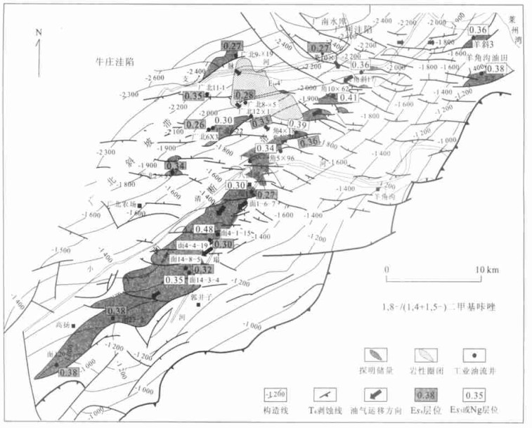
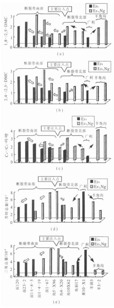
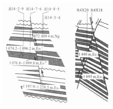
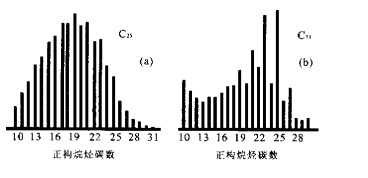
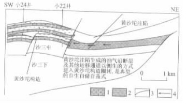
Petroleum migration study of Bamianhe oilfield of Dongying depression, eastern China is observed on the basis of detailed work of investigating genetic mechanism and source rock of the petroleum. It is proved that pyrrolic nitrogen compound, a kind of non-hydrocarbon fraction, could be used as parameters in evaluating the quantity of migrated oil. Besides the pyrrolic nitrogen compounds, absolute quantitative analysis of aromatics such as dibenzofuran, dibenzothiophene and fluorene are also used for the evaluation. The results indicate that the pyrrolic nitrogen compounds and some heavy molecular compounds such as dibenzothiophene in the oils reveal significant fractionation effects. First, the main charging point of the Bamianhe fracture belt is at the location of the Xiaoqinghe River, where Mian 1 to Jiao 4 wells are located and also the oils migrated from the main charging point to the south and north respectively. Second, in the south part of the fracture belt, there are obvious migration fractionation effect laterally and vertically, suggesting most of the oil being accumulated at the south part. While the northern part of the fracture belt just shows slight oil migration fractionation effect from the main charging point to north. Third, at the end of the northern part of the fracture belt, the migration direction is seen to be from north to south, suggesting another source-cooker nearby. Fourth, according to the fractionation effect of the nitrogen compounds and aromatics, fractures and unconformity surfaces are inferred as the main migration paths, and the oils of the Bamianhe oilfield are assumed to come mainly from Niuzhuang and Guangli sags. It is also suggested that the oils are probably generated from the deep parts of the Niuzhuang and Guangli sags, not as what is suggested previously from the shallow sedimentary intervals in the south slope of Niuzhuang sag. Therefore, most of the oils are in fact normal oils generated by source rock in the oil-generating window.
Petroleum migration study of Bamianhe oilfield of Dongying depression, eastern China is observed on the basis of detailed work of investigating genetic mechanism and source rock of the petroleum. It is proved that pyrrolic nitrogen compound, a kind of non-hydrocarbon fraction, could be used as parameters in evaluating the quantity of migrated oil. Besides the pyrrolic nitrogen compounds, absolute quantitative analysis of aromatics such as dibenzofuran, dibenzothiophene and fluorene are also used for the evaluation. The results indicate that the pyrrolic nitrogen compounds and some heavy molecular compounds such as dibenzothiophene in the oils reveal significant fractionation effects. First, the main charging point of the Bamianhe fracture belt is at the location of the Xiaoqinghe River, where Mian 1 to Jiao 4 wells are located and also the oils migrated from the main charging point to the south and north respectively. Second, in the south part of the fracture belt, there are obvious migration fractionation effect laterally and vertically, suggesting most of the oil being accumulated at the south part. While the northern part of the fracture belt just shows slight oil migration fractionation effect from the main charging point to north. Third, at the end of the northern part of the fracture belt, the migration direction is seen to be from north to south, suggesting another source-cooker nearby. Fourth, according to the fractionation effect of the nitrogen compounds and aromatics, fractures and unconformity surfaces are inferred as the main migration paths, and the oils of the Bamianhe oilfield are assumed to come mainly from Niuzhuang and Guangli sags. It is also suggested that the oils are probably generated from the deep parts of the Niuzhuang and Guangli sags, not as what is suggested previously from the shallow sedimentary intervals in the south slope of Niuzhuang sag. Therefore, most of the oils are in fact normal oils generated by source rock in the oil-generating window.
2002, 27(6): 671-675.
Abstract:
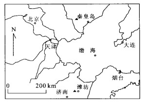
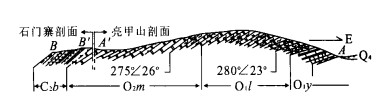
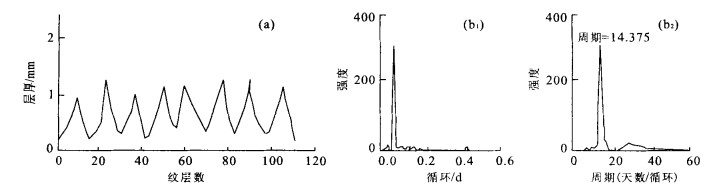
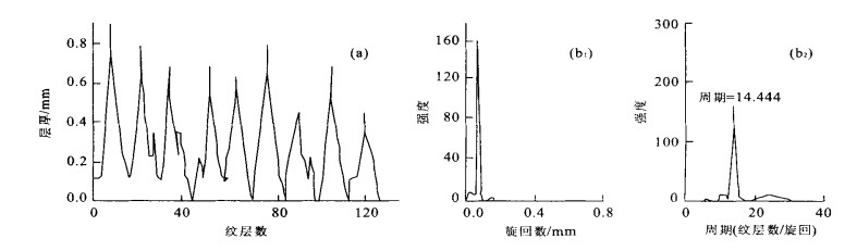
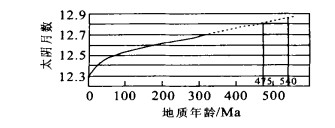
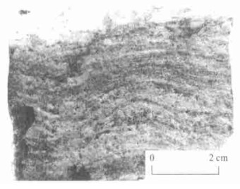
When the limestone of Cambrian-Ordovician from North China is polished and painted, the thickness of its little layers is read with the help of the magnifier. Then Fast Fourier transform and spectrum analysis is made and the tide period records in day, fortnight and month is identified from the laminae in the limestone. It was found that there were 29.9 d for a lunar month in Cambrian and in Ordovician 29.8 d; that there were 384.5 d for a year in Cambrian and in Ordovician 381.7 d and that there were 22.798 h for a day in Cambrian and in Ordovician 22.963 h. It has also been learned that Earth-Moon distances in Cambrian was 58.76 Earth's radius, in Ordovician 58.96 Earth's radius and that the lunar retreat rates in Cambrian was 4.25 cm·a -1 year and in Ordovician 4.18 cm·a -1. The result shows that the velocity of the Earth rotation had been slowed down from Cambrian to Ordovician, and that the Earth-Moon distance had been increasing while the rate of lunar retreat had been decreasing.
When the limestone of Cambrian-Ordovician from North China is polished and painted, the thickness of its little layers is read with the help of the magnifier. Then Fast Fourier transform and spectrum analysis is made and the tide period records in day, fortnight and month is identified from the laminae in the limestone. It was found that there were 29.9 d for a lunar month in Cambrian and in Ordovician 29.8 d; that there were 384.5 d for a year in Cambrian and in Ordovician 381.7 d and that there were 22.798 h for a day in Cambrian and in Ordovician 22.963 h. It has also been learned that Earth-Moon distances in Cambrian was 58.76 Earth's radius, in Ordovician 58.96 Earth's radius and that the lunar retreat rates in Cambrian was 4.25 cm·a -1 year and in Ordovician 4.18 cm·a -1. The result shows that the velocity of the Earth rotation had been slowed down from Cambrian to Ordovician, and that the Earth-Moon distance had been increasing while the rate of lunar retreat had been decreasing.
2002, 27(6): 676-682.
Abstract:
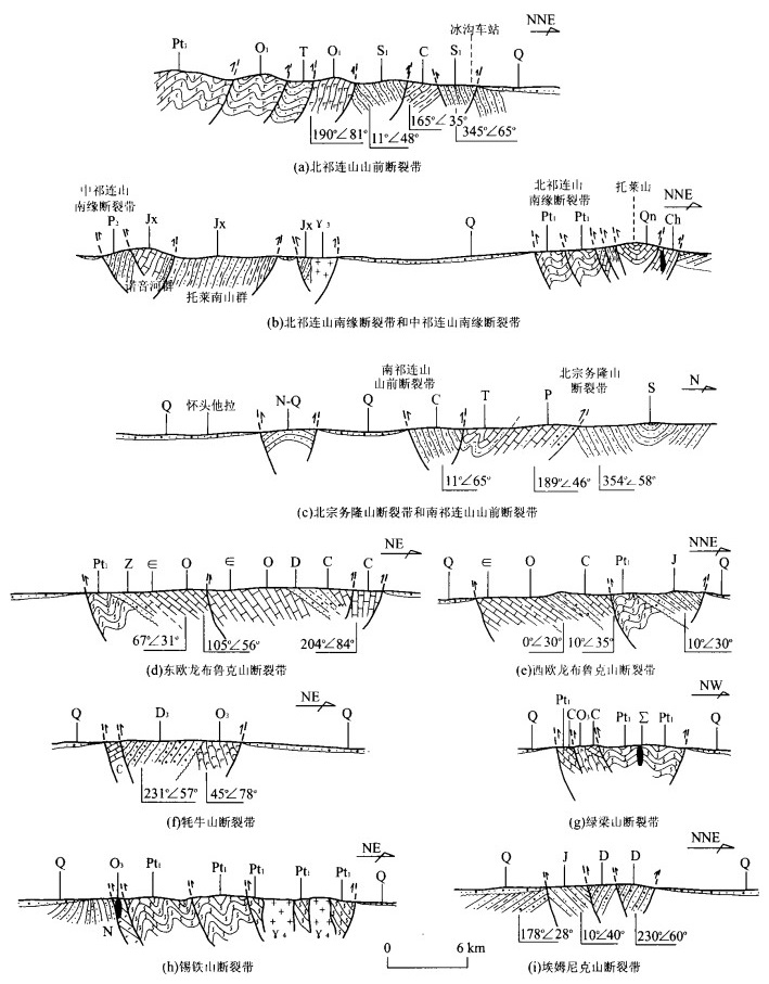
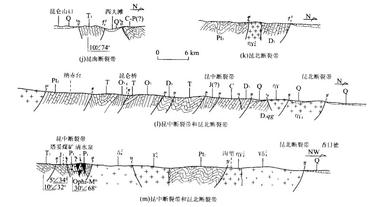
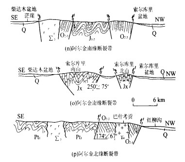
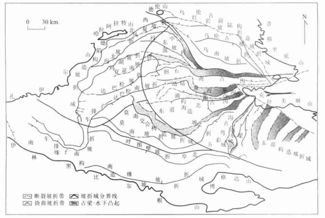
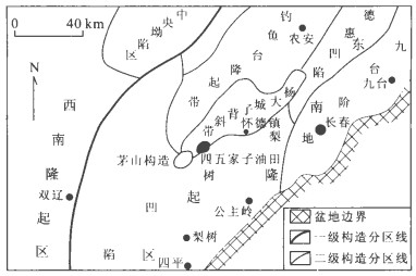
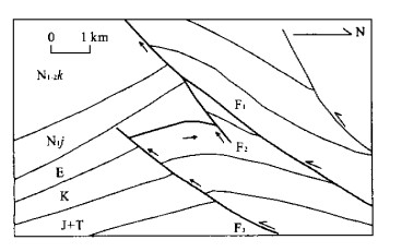
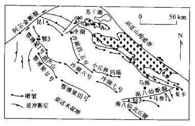
The purpose of this paper is to analyze the regional fault systems of Qaidam basin and adjacent orogenic belts. Field investigations and seismic interpretations indicate that five regional fault systems occurred in the basin and adjacent mountain belts and that they control the development and evolution of the Qaidam basin. These fault systems are: (1) Qilianshan-northern marginal Qaidam fault systems; (2) East Kunlunshan-southern marginal Qaidam fault systems; (3) Altun strike-slip fault systems; (4) Elashan strike-slip fault systems; (5) Gansen-Xiaochaidan fault systems. It is indicated that the fault systems have great control over the orientation of the Qaidam basin, the formation and distribution of secondary faults within the basin, the migration of sedimentary center and the distribution of hydrocarbon accumulation belts.
The purpose of this paper is to analyze the regional fault systems of Qaidam basin and adjacent orogenic belts. Field investigations and seismic interpretations indicate that five regional fault systems occurred in the basin and adjacent mountain belts and that they control the development and evolution of the Qaidam basin. These fault systems are: (1) Qilianshan-northern marginal Qaidam fault systems; (2) East Kunlunshan-southern marginal Qaidam fault systems; (3) Altun strike-slip fault systems; (4) Elashan strike-slip fault systems; (5) Gansen-Xiaochaidan fault systems. It is indicated that the fault systems have great control over the orientation of the Qaidam basin, the formation and distribution of secondary faults within the basin, the migration of sedimentary center and the distribution of hydrocarbon accumulation belts.

2002, 27(6): 683-688.
Abstract:
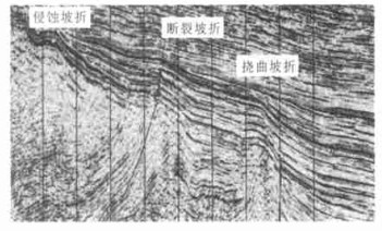
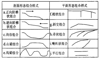
Slope breaks are developed in both marine and rift lake basins, and their controlling impact on sequence and deposition has already been widely concerned and accepted. However the study in Jurassic Junggar basin shows that slope breaks are also developed in large down-warped lake basins. Their genetic types can be divided into structural slope break, sedimentary slope break and erodent slope break. These breaks are distributed widely, showing mutual grades characteristics. On the profiles, they have forward direction grade combination, downward direction grade combination, ditch-valley combination, mountain combination and ditch-mountain combination. On the planes, they display pectination combination, broom combination, oblique combination, trumpet combination and parallel combination. A set of slope breaks developed in the specific structural settings with genetic correlations and similar combination characteristics consist of a structural slope break domain. The Jurassic lake basin, Junggar, was distinguished into 6 structural slope-break domains. It is evident that slope breaks have an important control on sequence, deposition and the development of tectonic traps and different water systems and different depositional characteristics are formed in different structural slope-break domains.
Slope breaks are developed in both marine and rift lake basins, and their controlling impact on sequence and deposition has already been widely concerned and accepted. However the study in Jurassic Junggar basin shows that slope breaks are also developed in large down-warped lake basins. Their genetic types can be divided into structural slope break, sedimentary slope break and erodent slope break. These breaks are distributed widely, showing mutual grades characteristics. On the profiles, they have forward direction grade combination, downward direction grade combination, ditch-valley combination, mountain combination and ditch-mountain combination. On the planes, they display pectination combination, broom combination, oblique combination, trumpet combination and parallel combination. A set of slope breaks developed in the specific structural settings with genetic correlations and similar combination characteristics consist of a structural slope break domain. The Jurassic lake basin, Junggar, was distinguished into 6 structural slope-break domains. It is evident that slope breaks have an important control on sequence, deposition and the development of tectonic traps and different water systems and different depositional characteristics are formed in different structural slope-break domains.
2002, 27(6): 689-695.
Abstract:
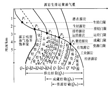
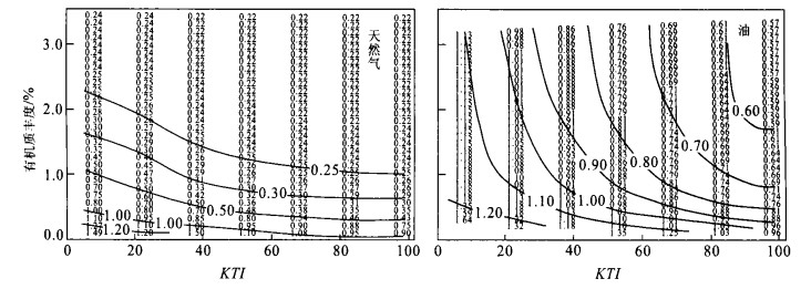
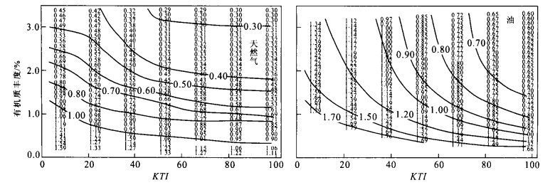
A series of thresholds, such as thresholds of hydrocarbon generation, expulsion, accumulation and resources, may occur during reservoir formation. Part of hydrocarbons are consumed in certain reservoir system of petroleum when reaching a threshold. Oil and gas supplied by source rocks in practical geological conditions can be accumulated to form reservoir in larger scale and be of promising oil and gas exploration future only after hydrocarbon generation amount from the source rock is more than the sum of hydrocarbon lost across each threshold. Source rocks can be called valid source rock only when the excessive oil and gas come from them can form a commercial reservoir after the amount of hydrocarbons generated by the source rock meets the need of all kinds of wasting during the process of reservoir formation. The paper presents geologic meanings, judging standards, mechanisms of controlling oil and gas of thresholds and their application in Paleozoic carbonate source rock evaluation in Tarim basin. Researches indicate that there is not a minimum lower limit of organic matter abundance which can be used validly everywhere. While the minimum lower limit of organic matter abundance was affected by conditions of the source rock itself, together with the geological conditions of reservoir formation.
A series of thresholds, such as thresholds of hydrocarbon generation, expulsion, accumulation and resources, may occur during reservoir formation. Part of hydrocarbons are consumed in certain reservoir system of petroleum when reaching a threshold. Oil and gas supplied by source rocks in practical geological conditions can be accumulated to form reservoir in larger scale and be of promising oil and gas exploration future only after hydrocarbon generation amount from the source rock is more than the sum of hydrocarbon lost across each threshold. Source rocks can be called valid source rock only when the excessive oil and gas come from them can form a commercial reservoir after the amount of hydrocarbons generated by the source rock meets the need of all kinds of wasting during the process of reservoir formation. The paper presents geologic meanings, judging standards, mechanisms of controlling oil and gas of thresholds and their application in Paleozoic carbonate source rock evaluation in Tarim basin. Researches indicate that there is not a minimum lower limit of organic matter abundance which can be used validly everywhere. While the minimum lower limit of organic matter abundance was affected by conditions of the source rock itself, together with the geological conditions of reservoir formation.
2002, 27(6): 696-702.
Abstract:
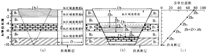
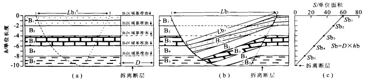
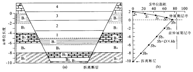
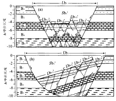
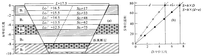
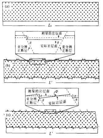
Extensional basin includes mainly graben and half-graben controlled by low detachment. Based on the area-balance theory, there is a linear equation between a height of regional to detachment (h) on the outside of the basin and lose area (S) of the regional in extensional basin. The basement beds above detachment are of same extensional displacement so that "S-h diagram" can be used to determine the depth to detachment and to calculate the total extensional displacement of the beds above detachment. The extensional displacement is dominated by the heave of various scale normal faults. The displacement of obvious faults can be immediately figured out by measured bed-length. The requisite displacement calculated by area balance is the layer-parallel strain, which could be the extensional displacement of sub-resolution faults. Accordingly, the layer-parallel strain can help us to predict the magnitude and distribution of sub-resolution fault on the base of analysis of structural style and rheological behaviour.
Extensional basin includes mainly graben and half-graben controlled by low detachment. Based on the area-balance theory, there is a linear equation between a height of regional to detachment (h) on the outside of the basin and lose area (S) of the regional in extensional basin. The basement beds above detachment are of same extensional displacement so that "S-h diagram" can be used to determine the depth to detachment and to calculate the total extensional displacement of the beds above detachment. The extensional displacement is dominated by the heave of various scale normal faults. The displacement of obvious faults can be immediately figured out by measured bed-length. The requisite displacement calculated by area balance is the layer-parallel strain, which could be the extensional displacement of sub-resolution faults. Accordingly, the layer-parallel strain can help us to predict the magnitude and distribution of sub-resolution fault on the base of analysis of structural style and rheological behaviour.
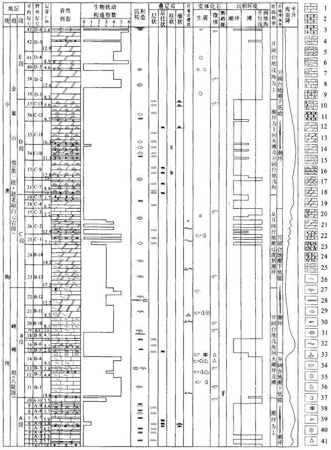
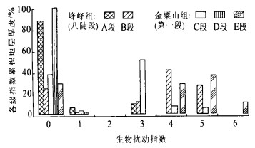
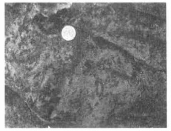
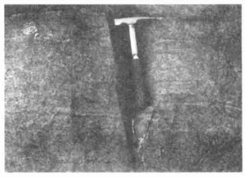
Bioturbation Structures and Paleoenvironment Analysis of the Middle Ordovician at Jinsushan, Shaanxi
2002, 27(6): 703-710.
Abstract:
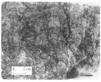
Trace fossils and bioturbation structures were first discovered from the Middle Ordovician Badou Member of Fengfeng Formation and the Member 1 of Jinsushan Formation at Jinsushan, Shaanxi Province, sourthern margin of Ordos basin, where plentiful bioturbation structures are composed of unidentified species and genera and abundant stromatolites. The analysis of the characteristics and distribution of bioturbation structures, with stromatolites and sedimentology research and a method of semi-quantitative analysis for bioturbation structures enabled the authors to explain paleoenvironments of related formations. They suggest that there were three times of paleoenvironmental changes from the stromatolite-developing tidal flat to low energy open platform shallow sea enviroments, that is, three larger-scale fluctuations of sea level, during the Middle Ordovician Badou Member of Fengfeng Formation to the Member 1 of Jinsushan Formation.
Trace fossils and bioturbation structures were first discovered from the Middle Ordovician Badou Member of Fengfeng Formation and the Member 1 of Jinsushan Formation at Jinsushan, Shaanxi Province, sourthern margin of Ordos basin, where plentiful bioturbation structures are composed of unidentified species and genera and abundant stromatolites. The analysis of the characteristics and distribution of bioturbation structures, with stromatolites and sedimentology research and a method of semi-quantitative analysis for bioturbation structures enabled the authors to explain paleoenvironments of related formations. They suggest that there were three times of paleoenvironmental changes from the stromatolite-developing tidal flat to low energy open platform shallow sea enviroments, that is, three larger-scale fluctuations of sea level, during the Middle Ordovician Badou Member of Fengfeng Formation to the Member 1 of Jinsushan Formation.
2002, 27(6): 711-717.
Abstract:
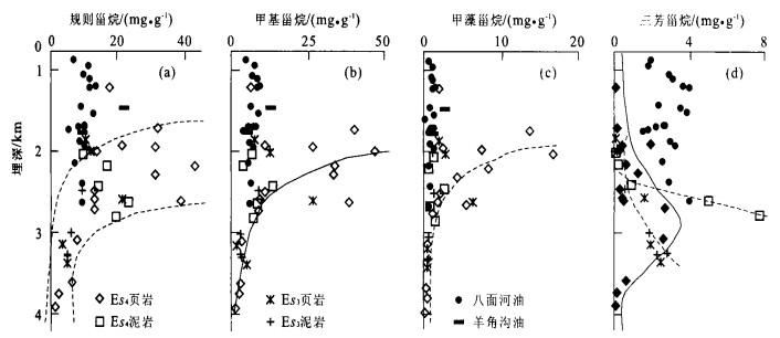
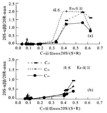
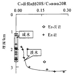
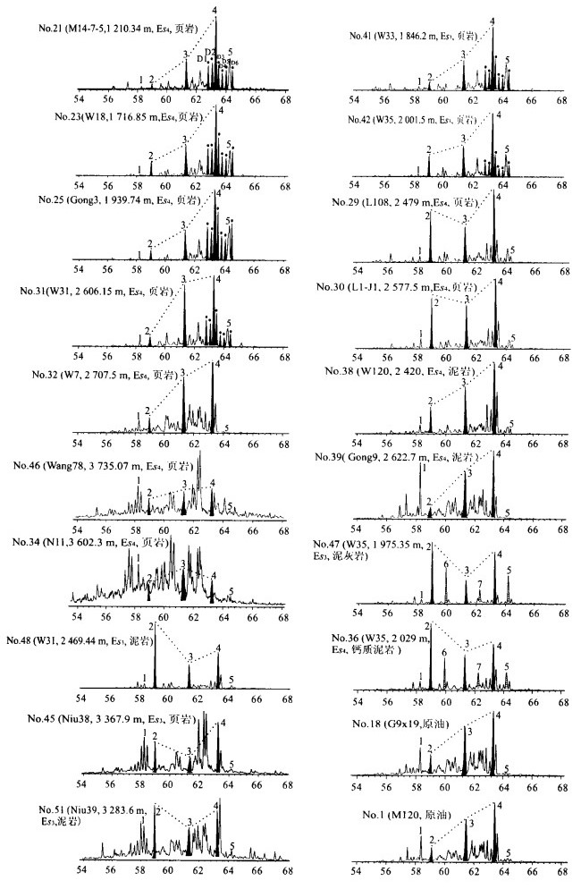
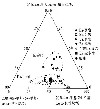
samples of shales and mudstones developed in reducing hypersaline and freshwater setting and 20 oil samples of Bamianhe oilfield, Bohai Bay basin were collected for a detailed study of petroleum system. Composition and distribution of specific significance of steroids were discussed as a part of the study. Abundant steroidal biomarkers including C27-29 regular steranes, C28-30 4-methyl steranes, dinosteranes and aromatic steranes were detected. The composition and distribution of the steroids in the samples studied were a function of thermal maturity, organic source, paleoenvironment and lithology of potential source rocks. Alga-rich Es4 shales (brackish water) developed in the south slope of depocenter (Niuzhuang sag) were found particularly rich in steroidal biomarkers including C30 4-methyl steranes and dinosteranes. While Es3 mudstones (fresh water) displayed devoid of dinosterane, abundant 4-β steranes were only found in argillaceous limestone and calcareous mudstone, clearly distinguished from the other rocks. Distribution patterns of regular steranes are different from methyl steranes completely indicating different origins of specific compound of the fraction. Isomerization of steroids were observed to be determined by paleoenvironment and lithology besides thermal maturity. Methyl steranes were proved much more useful in oil-source rock correlation than regular steranes. It was not possible that alga-rich Es4 shales located on the south slope were the primary source rock responsible for the oil discovered based on composition and distribution of steroids.
samples of shales and mudstones developed in reducing hypersaline and freshwater setting and 20 oil samples of Bamianhe oilfield, Bohai Bay basin were collected for a detailed study of petroleum system. Composition and distribution of specific significance of steroids were discussed as a part of the study. Abundant steroidal biomarkers including C27-29 regular steranes, C28-30 4-methyl steranes, dinosteranes and aromatic steranes were detected. The composition and distribution of the steroids in the samples studied were a function of thermal maturity, organic source, paleoenvironment and lithology of potential source rocks. Alga-rich Es4 shales (brackish water) developed in the south slope of depocenter (Niuzhuang sag) were found particularly rich in steroidal biomarkers including C30 4-methyl steranes and dinosteranes. While Es3 mudstones (fresh water) displayed devoid of dinosterane, abundant 4-β steranes were only found in argillaceous limestone and calcareous mudstone, clearly distinguished from the other rocks. Distribution patterns of regular steranes are different from methyl steranes completely indicating different origins of specific compound of the fraction. Isomerization of steroids were observed to be determined by paleoenvironment and lithology besides thermal maturity. Methyl steranes were proved much more useful in oil-source rock correlation than regular steranes. It was not possible that alga-rich Es4 shales located on the south slope were the primary source rock responsible for the oil discovered based on composition and distribution of steroids.
2002, 27(6): 718-722.
Abstract:
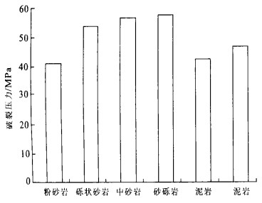
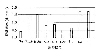
Insulating layer of deep reservoirs in eastern China involves a large number of fractures because of its low breakdown pressure and high effective stress loaded, and as a result, its sealing capability is decreased. Taking the Gaoshangpu Es32+3 Member reservoir as an example, this paper studies its basic characteristics and distribution law of the fractures in the deep reservoir, analyzes their origin and effect on water-flooding, and offers corresponding solutions. Research of insulating fractures is very important for reservoir dynamic analysis and improving water-flooding level.
Insulating layer of deep reservoirs in eastern China involves a large number of fractures because of its low breakdown pressure and high effective stress loaded, and as a result, its sealing capability is decreased. Taking the Gaoshangpu Es32+3 Member reservoir as an example, this paper studies its basic characteristics and distribution law of the fractures in the deep reservoir, analyzes their origin and effect on water-flooding, and offers corresponding solutions. Research of insulating fractures is very important for reservoir dynamic analysis and improving water-flooding level.
2002, 27(6): 723-728.
Abstract:
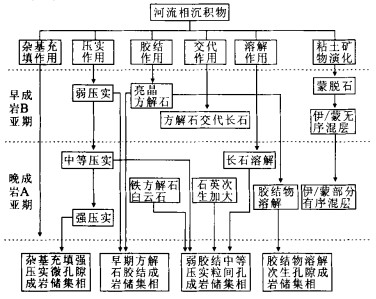
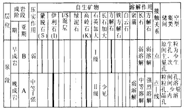
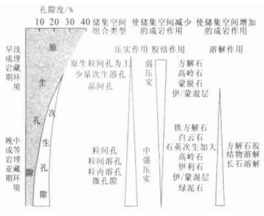
Based on the analytic data of casting thin section, scanning electron microscope, X-ray diffraction of clay minerals of well core samples at Siwujiazi oilfield, the diageneses, diagenetic sequences and stages of the Second Member of Quantou Formation of the Lower Cretaceous were studied. The study suggests that its reservoir rocks can be divided into 4 types of diagenetic-reservoir facies, i.e. facies A, which has undergone weak cementation and middle compaction and has interparticle pores; facies B, in which calcite cements have been greatly dissolved and secondary dissolution pores have been developed; facies C, which has undergone strong compaction and has micro pores, showing matrix filled in interparticles; facies D, which has undergone early calcite cementation. The characteristics and origin of each diagenesis-reservoir facies are described in detail. Finally the types and evolution of pore space are discussed.
Based on the analytic data of casting thin section, scanning electron microscope, X-ray diffraction of clay minerals of well core samples at Siwujiazi oilfield, the diageneses, diagenetic sequences and stages of the Second Member of Quantou Formation of the Lower Cretaceous were studied. The study suggests that its reservoir rocks can be divided into 4 types of diagenetic-reservoir facies, i.e. facies A, which has undergone weak cementation and middle compaction and has interparticle pores; facies B, in which calcite cements have been greatly dissolved and secondary dissolution pores have been developed; facies C, which has undergone strong compaction and has micro pores, showing matrix filled in interparticles; facies D, which has undergone early calcite cementation. The characteristics and origin of each diagenesis-reservoir facies are described in detail. Finally the types and evolution of pore space are discussed.
2002, 27(6): 729-732.
Abstract:
Lens-shaped sand body oil-gas reservoir is an important kind of lithological oil-gas reservoir. It is widely distributed in Jiyang depression. The statistical data of the degree of oil-gas charged in the lens-shaped sand body (the ratio of the volume of the sand body charged by oil and/or gas to the volume of lens-shaped sand body) in Jiyang depression shows that the degree of oil-gas charged is between 26.8% and 94.1% with an average of 55%. While the degree of oil-gas charged in the overwhelming majority of lens-shaped sand bodies is over 40%, and the degree of most of lens-shaped sand bodies is over 60%. lens-shaped sand body oil-gas reservoir is mainly distributed in the Fourth, the Third and the Second sections of Shahejie Formation. It is found that the degree of oil-gas charged in the Third Section of Shahejie Formation is the highest, averaged at 59%, and the next is in the Second Section with an average of 50%. The degree of oil-gas charged in the Fourth Section is the lowest; its average is only 33%. The primary factor analysis of main controlling factors for the degree of oil-gas charged in the lens-shaped sand bodies suggests that the most important controlling factors are geometry of the lens-shaped sand bodies (thickness and area of the lens-shaped sand body) and the oil-gas migration conditions (the quantity of fault within the lens-shaped sand bodies, the distance between the lens-shaped sand body and source rock and the surplus pressure within the lens-shaped sand bodies). The second important controlling factor is the porosity and permeability of the lens-shaped sand body.
Lens-shaped sand body oil-gas reservoir is an important kind of lithological oil-gas reservoir. It is widely distributed in Jiyang depression. The statistical data of the degree of oil-gas charged in the lens-shaped sand body (the ratio of the volume of the sand body charged by oil and/or gas to the volume of lens-shaped sand body) in Jiyang depression shows that the degree of oil-gas charged is between 26.8% and 94.1% with an average of 55%. While the degree of oil-gas charged in the overwhelming majority of lens-shaped sand bodies is over 40%, and the degree of most of lens-shaped sand bodies is over 60%. lens-shaped sand body oil-gas reservoir is mainly distributed in the Fourth, the Third and the Second sections of Shahejie Formation. It is found that the degree of oil-gas charged in the Third Section of Shahejie Formation is the highest, averaged at 59%, and the next is in the Second Section with an average of 50%. The degree of oil-gas charged in the Fourth Section is the lowest; its average is only 33%. The primary factor analysis of main controlling factors for the degree of oil-gas charged in the lens-shaped sand bodies suggests that the most important controlling factors are geometry of the lens-shaped sand bodies (thickness and area of the lens-shaped sand body) and the oil-gas migration conditions (the quantity of fault within the lens-shaped sand bodies, the distance between the lens-shaped sand body and source rock and the surplus pressure within the lens-shaped sand bodies). The second important controlling factor is the porosity and permeability of the lens-shaped sand body.
2002, 27(6): 733-735.
Abstract:
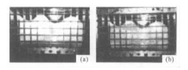
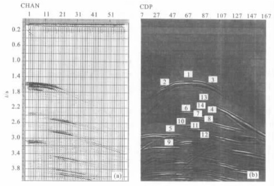
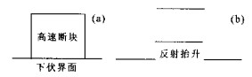
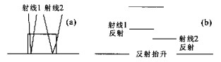
Faults are common geological structures and fault interpretation is an important part in seismic interpretation. A seismic modeling experiment was done to study seismic reflection characteristics of faults, including how faults influence the reflections of deeper layers and layers beside faults and the characteristics of wave scattering of fault points. In our opinions, what we know about wave characteristics of faults is incomplete and so our experiment shows that the wave characteristics are complex and there maybe traps for seismic interpretation. Our analysis ascertained the existence of interpretation traps, their types and their causes, which will surely help enhance seismic interpretations.
Faults are common geological structures and fault interpretation is an important part in seismic interpretation. A seismic modeling experiment was done to study seismic reflection characteristics of faults, including how faults influence the reflections of deeper layers and layers beside faults and the characteristics of wave scattering of fault points. In our opinions, what we know about wave characteristics of faults is incomplete and so our experiment shows that the wave characteristics are complex and there maybe traps for seismic interpretation. Our analysis ascertained the existence of interpretation traps, their types and their causes, which will surely help enhance seismic interpretations.
2002, 27(6): 736-740.
Abstract:
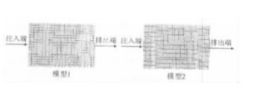
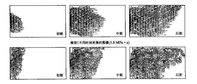
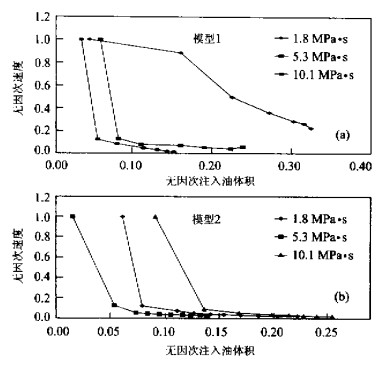
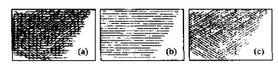
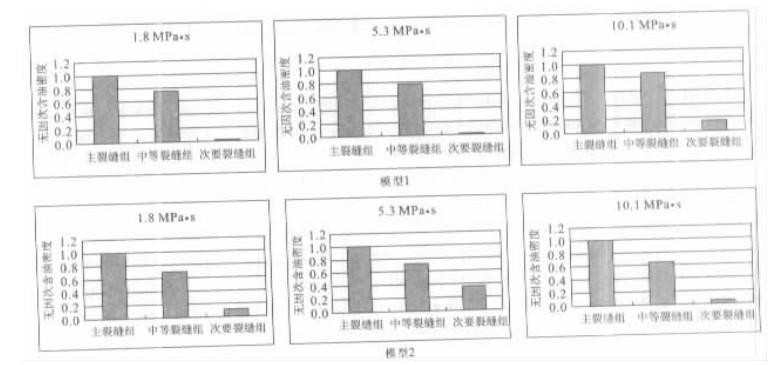
A series of physical experiments on petroleum migration in water saturated fractured media are performed by using two designed models. The objective of the experiments is to study the influences of fracture topography, fracture width and oil viscosity in oil migration. The experiment results demonstrate that the direction of fractures with the greatest width controls mainly the migration direction and distribution of oil in fractured media. It is also found that when the decreasing direction of fluid potential is parallel to the direction of fractures with the greatest width, migration velocity and migration quantity increase with the decrease of oil viscosity. But the relationships among migration velocity, migration quantity and oil viscosity are more complex when the decreasing direction of fluid potential is perpendicular to the direction of fractures. The results clarify that it is essential to study the combined effect of paleo-stress and paleo-potential distributions in identifying the direction of oil migration and accumulation.
A series of physical experiments on petroleum migration in water saturated fractured media are performed by using two designed models. The objective of the experiments is to study the influences of fracture topography, fracture width and oil viscosity in oil migration. The experiment results demonstrate that the direction of fractures with the greatest width controls mainly the migration direction and distribution of oil in fractured media. It is also found that when the decreasing direction of fluid potential is parallel to the direction of fractures with the greatest width, migration velocity and migration quantity increase with the decrease of oil viscosity. But the relationships among migration velocity, migration quantity and oil viscosity are more complex when the decreasing direction of fluid potential is perpendicular to the direction of fractures. The results clarify that it is essential to study the combined effect of paleo-stress and paleo-potential distributions in identifying the direction of oil migration and accumulation.
2002, 27(6): 741-744.
Abstract:
Himalayan orogeny refers to the tectonic movement from Cenozoic, and it is the main power responsible for the formation of depressions and traps. Therefore, it plays an important role in oil and gas forming in Kuqa depression, Tarim basin. Rapid sedimentation and embedding by violent tectonic extrusion of Himalayan orogeny caused oil and gas to form. A lot of fractures formed by the orogeny are the main seepage and the valid storage space to improve the capability of low-permeability reservoir. Fault related with fold formed in the early Himalayan orogeny and ended in its late stage is the most favorable structural trap. Himalayan orogeny not only formed migration passage and accumulation location of oil and gas in Kuqa depression, but also was the main power for oil and gas migration. Meanwhile, it controlled oil and gas pool to be distributed in rows and zones. Faults and tectonic uplift in the late stage of Himalayan orogeny are the main factors on gas dissipating and the secondary oil and gas pool forming above salt layer in Eogene.
Himalayan orogeny refers to the tectonic movement from Cenozoic, and it is the main power responsible for the formation of depressions and traps. Therefore, it plays an important role in oil and gas forming in Kuqa depression, Tarim basin. Rapid sedimentation and embedding by violent tectonic extrusion of Himalayan orogeny caused oil and gas to form. A lot of fractures formed by the orogeny are the main seepage and the valid storage space to improve the capability of low-permeability reservoir. Fault related with fold formed in the early Himalayan orogeny and ended in its late stage is the most favorable structural trap. Himalayan orogeny not only formed migration passage and accumulation location of oil and gas in Kuqa depression, but also was the main power for oil and gas migration. Meanwhile, it controlled oil and gas pool to be distributed in rows and zones. Faults and tectonic uplift in the late stage of Himalayan orogeny are the main factors on gas dissipating and the secondary oil and gas pool forming above salt layer in Eogene.
2002, 27(6): 745-750.
Abstract:
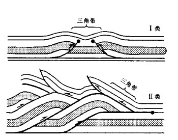
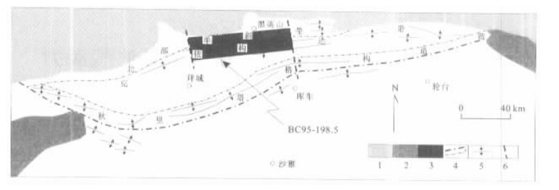
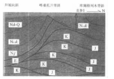
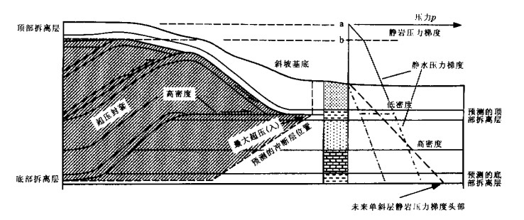
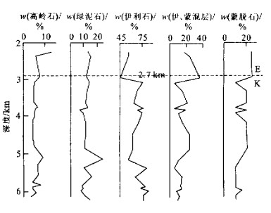
The Kelasu triangle zone occurs under the Paleogene evaporites in Kelasu anticline zone of Kuqa thrust-and-fold belts, Tarim basin (Northwest China). The triangle zone was about to start originally in the middle Miocene, developed between the Paleogene evaporites and the Jurassic coal-bearing strata, and fell under Ⅱ-type of triangle zones. While in the Pliocene, the Kelasu triangle zone was broken through at the bottom. The tectonic fronts of the Kuqa thrust-and-fold belts expanded to the Qiuli Tagh anticline zone. It is discovered that the development of the Kelasu triangle zone is related to the evolution of an overpressure envelop, and the broken layer is assumed to coincide with a mechanical boundary related to the smectite to illite transition lain under the Paleogene evaporites. The deep traps of the Kelasu triangle zone are potential targets that should be distinguished from strike-slip faults such as transfer zones for hydrocarbon exploration.
The Kelasu triangle zone occurs under the Paleogene evaporites in Kelasu anticline zone of Kuqa thrust-and-fold belts, Tarim basin (Northwest China). The triangle zone was about to start originally in the middle Miocene, developed between the Paleogene evaporites and the Jurassic coal-bearing strata, and fell under Ⅱ-type of triangle zones. While in the Pliocene, the Kelasu triangle zone was broken through at the bottom. The tectonic fronts of the Kuqa thrust-and-fold belts expanded to the Qiuli Tagh anticline zone. It is discovered that the development of the Kelasu triangle zone is related to the evolution of an overpressure envelop, and the broken layer is assumed to coincide with a mechanical boundary related to the smectite to illite transition lain under the Paleogene evaporites. The deep traps of the Kelasu triangle zone are potential targets that should be distinguished from strike-slip faults such as transfer zones for hydrocarbon exploration.
2002, 27(6): 751-756.
Abstract:
It is believed by the fault controlling hydrocarbon theory that fault is the basic reason controlling hydrocarbon generation, migration, accumulation, scattering and distribution and that relationship between faults and hydrocarbon accumulations is the relationship between branches and fruits or cane and melon, and scientific exploration train of thought must "fetch fruits (hydrocarbon accumulations) along branches (faults) " or "probe into melons (hydrocarbon accumulations) according to canes (faults) ". Researches indicate that according to "fault controlling hydrocarbon theory", there are better petroleum accumulation conditions in buried hills because of existing transporting hydrocarbon faults in Tanggu buried hill of Beitang depression. While there are very obvious features of fault controlling hydrocarbon in Qaidam basin and also evident laws of fault controlling hydrocarbon generating, migrating, accumulating, scattering and distributing, the controlling hydrocarbon faults are very active and there is huge petroleum resource potential in the middle region of the basin. It is discovered that the geological conditions are advantageous for the huge hydrocarbon accumulations there. Therefore, the middle region of the basin is the most important exploration belts where the petroleum exploration will possibly make a great breakthrough. In HNFS depression, the "fault controlling hydrocarbon theory" helps us to find the main generating hydrocarbon sag, thus opening up a new petroleum exploration district.
It is believed by the fault controlling hydrocarbon theory that fault is the basic reason controlling hydrocarbon generation, migration, accumulation, scattering and distribution and that relationship between faults and hydrocarbon accumulations is the relationship between branches and fruits or cane and melon, and scientific exploration train of thought must "fetch fruits (hydrocarbon accumulations) along branches (faults) " or "probe into melons (hydrocarbon accumulations) according to canes (faults) ". Researches indicate that according to "fault controlling hydrocarbon theory", there are better petroleum accumulation conditions in buried hills because of existing transporting hydrocarbon faults in Tanggu buried hill of Beitang depression. While there are very obvious features of fault controlling hydrocarbon in Qaidam basin and also evident laws of fault controlling hydrocarbon generating, migrating, accumulating, scattering and distributing, the controlling hydrocarbon faults are very active and there is huge petroleum resource potential in the middle region of the basin. It is discovered that the geological conditions are advantageous for the huge hydrocarbon accumulations there. Therefore, the middle region of the basin is the most important exploration belts where the petroleum exploration will possibly make a great breakthrough. In HNFS depression, the "fault controlling hydrocarbon theory" helps us to find the main generating hydrocarbon sag, thus opening up a new petroleum exploration district.
2002, 27(6): 757-762.
Abstract:
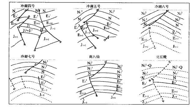
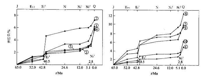
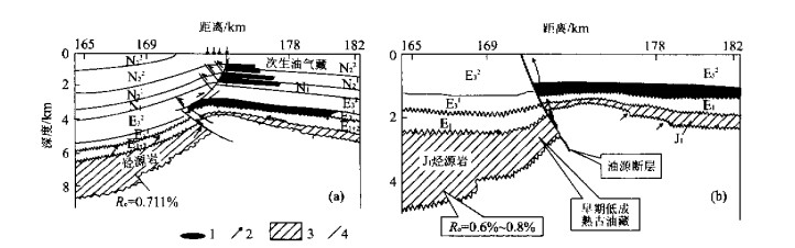
The northwestern Qaidam basin is a Jurassic-Tertiary petroleum system. Thrust faults and anticlines are related with faults form main types of traps of the area. The E32 and N23-Q are the two key elements for the formation of the traps and for the migration and accumulation of petroleum. The composition of petroleum in the reservoirs and in the inclusions indicates that the reservoirs of the Eocene and Neocene underwent different times and stages of petroleum filling. The reservoir of Eocene underwent two stages of petroleum filling: in the end of Eocene, the low-mature petroleum was formed at the end of Jurassic period and entrapped in the Jurassic reservoirs and the mature petroleum formed at the end of Eocene epoch migrated up through the faults and was mixed in the Eocene reservoirs. During N23-Q, newly formed high-mature petroleum migrated up once more through the reliving faults and was mixed with the petroleum in the Eocene reservoirs. While the reservoirs of the Neocene mainly underwent one stage of petroleum filling. During N23-Q, petroleum in the Eocene reservoirs was pumped up through faults, with some petroleum entrapped secondly in the Neocene reservoirs and some petroleum escaped to the surface. It is concluded that the faults played a very important role in the migration and accumulation of petroleum in the Tertiary system of the northwestern Qaidam basin.
The northwestern Qaidam basin is a Jurassic-Tertiary petroleum system. Thrust faults and anticlines are related with faults form main types of traps of the area. The E32 and N23-Q are the two key elements for the formation of the traps and for the migration and accumulation of petroleum. The composition of petroleum in the reservoirs and in the inclusions indicates that the reservoirs of the Eocene and Neocene underwent different times and stages of petroleum filling. The reservoir of Eocene underwent two stages of petroleum filling: in the end of Eocene, the low-mature petroleum was formed at the end of Jurassic period and entrapped in the Jurassic reservoirs and the mature petroleum formed at the end of Eocene epoch migrated up through the faults and was mixed in the Eocene reservoirs. During N23-Q, newly formed high-mature petroleum migrated up once more through the reliving faults and was mixed with the petroleum in the Eocene reservoirs. While the reservoirs of the Neocene mainly underwent one stage of petroleum filling. During N23-Q, petroleum in the Eocene reservoirs was pumped up through faults, with some petroleum entrapped secondly in the Neocene reservoirs and some petroleum escaped to the surface. It is concluded that the faults played a very important role in the migration and accumulation of petroleum in the Tertiary system of the northwestern Qaidam basin.
2002, 27(6): 763-766.
Abstract:
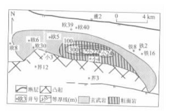
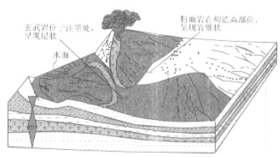
There are two kinds of lavas in the east depression of Liaohe oilfield. One is trachyte, the main lava reservoir in the area, and the other is basalt. By researching the extension, composition and cause of formation, the paper verifies the reason why the trachyte becomes good reservoir. By contrast, it also gives the reason for which the basalt doesn't contain oil and gas. It concludes that because of its high silicon contents, the trachyte is difficult to flow, and is easy to pile up at the top of structure. Therefore, its main body is beyond the surface. Good crystal brings about its perfect reserve characters. At the same time, the trachyte has lots of cracks. All the facts make the trachyte an excellent reservoir. In the end, the paper presents a pattern of forming reservoir for lava. It points out that its style of oil supply is a side-product and its style of forming reservoir is self-produced, self-reserved and self-sealed.
There are two kinds of lavas in the east depression of Liaohe oilfield. One is trachyte, the main lava reservoir in the area, and the other is basalt. By researching the extension, composition and cause of formation, the paper verifies the reason why the trachyte becomes good reservoir. By contrast, it also gives the reason for which the basalt doesn't contain oil and gas. It concludes that because of its high silicon contents, the trachyte is difficult to flow, and is easy to pile up at the top of structure. Therefore, its main body is beyond the surface. Good crystal brings about its perfect reserve characters. At the same time, the trachyte has lots of cracks. All the facts make the trachyte an excellent reservoir. In the end, the paper presents a pattern of forming reservoir for lava. It points out that its style of oil supply is a side-product and its style of forming reservoir is self-produced, self-reserved and self-sealed.
2002, 27(6): 767-769.
Abstract:
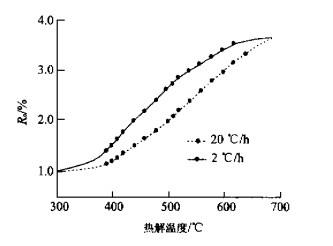
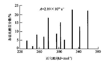
This paper simulates thermal evolution of Ordovician kerogen selected from well Tacan 1 in Tarim basin by pyrolysis kinetics simulating experiment. Based on the experiment, this research calculates kinetic parameters of kerogen vitrinite reflectance (Ro) through KINETICS software, and then calculates Cambrian-Ordovician paleotemperature of the well Tacan 1 combined with burial history. Kerogen pyrolysis kinetics simulating experiment is a new method to study the paleotemperature of Low Paleozoic over-high maturity source rocks in Tarim basin.
This paper simulates thermal evolution of Ordovician kerogen selected from well Tacan 1 in Tarim basin by pyrolysis kinetics simulating experiment. Based on the experiment, this research calculates kinetic parameters of kerogen vitrinite reflectance (Ro) through KINETICS software, and then calculates Cambrian-Ordovician paleotemperature of the well Tacan 1 combined with burial history. Kerogen pyrolysis kinetics simulating experiment is a new method to study the paleotemperature of Low Paleozoic over-high maturity source rocks in Tarim basin.
2002, 27(6): 770-774.
Abstract:
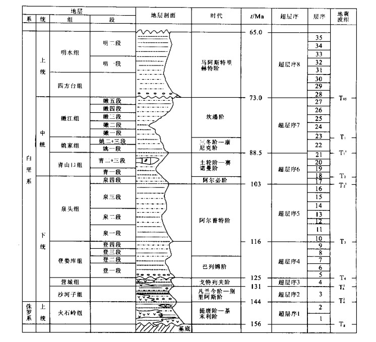
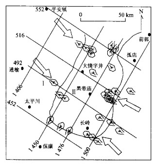
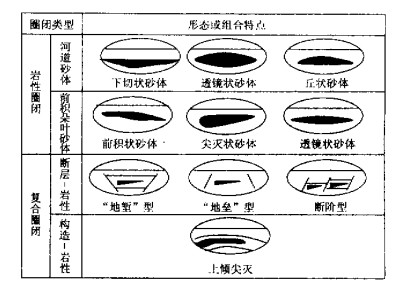
By using the theory of sequence stratigraphy, this paper establishes a standard for sequence classification and sequence framework in Changling sag, Songliao basin. Accordingly, we distinguish eight supersequences (second-order sequence) and thirty-five third-order sequences. T1 and T2 were recognized to be mfs (condensed section), and T3, T4, T41, T42 and Tg to be supersequence bounding surfaces. The study of the sedimentary systems formed in these five periods revealed the formation mechanism and spatial distribution of sedimentary bodies. Meanwhile, we also studied the distribution and oil-bearing characteristics of sedimentary reservoirs. On the basis of the study of oil/gas distribution in the sequence framework, we found that oil-/gas-bearing beds are mainly distributed in lowstand systems tract. The statistical study of well testing results shows that 48.2% of oil beds are in lowstand systems tract, 26.8% in trangressive systems tract (TST) and 25.0% in highstand systems tract. For the exploration purpose, the encountered lithologic traps and polygenesis traps are divided into four types: river course stone, frontal sedimentary leafy sand body, fault-lithology and structure-lithology sand body. Hence, this paper draws up the method for subtle reservoir exploration and finally makes the prediction of the subtle oil/gas reservoirs and the suggestions for the exploration plan in Changling sag.
By using the theory of sequence stratigraphy, this paper establishes a standard for sequence classification and sequence framework in Changling sag, Songliao basin. Accordingly, we distinguish eight supersequences (second-order sequence) and thirty-five third-order sequences. T1 and T2 were recognized to be mfs (condensed section), and T3, T4, T41, T42 and Tg to be supersequence bounding surfaces. The study of the sedimentary systems formed in these five periods revealed the formation mechanism and spatial distribution of sedimentary bodies. Meanwhile, we also studied the distribution and oil-bearing characteristics of sedimentary reservoirs. On the basis of the study of oil/gas distribution in the sequence framework, we found that oil-/gas-bearing beds are mainly distributed in lowstand systems tract. The statistical study of well testing results shows that 48.2% of oil beds are in lowstand systems tract, 26.8% in trangressive systems tract (TST) and 25.0% in highstand systems tract. For the exploration purpose, the encountered lithologic traps and polygenesis traps are divided into four types: river course stone, frontal sedimentary leafy sand body, fault-lithology and structure-lithology sand body. Hence, this paper draws up the method for subtle reservoir exploration and finally makes the prediction of the subtle oil/gas reservoirs and the suggestions for the exploration plan in Changling sag.
2002, 27(6): 775-779.
Abstract:
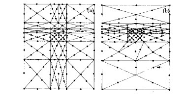
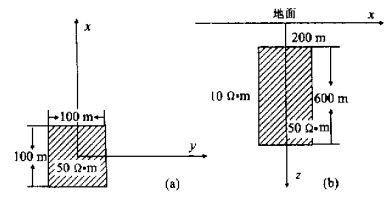
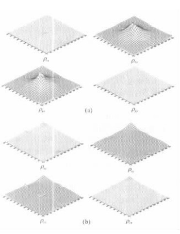
Based on the Maxwell's equations of electromagnetic field, this paper introduces equations of the finite element method for the boundary problem of the electromagnetic field and variation formula. In numerical calculation, the rectangular body elements fitted to simulate complex geology structure and topography relief were selected for discontinuity calculating areas. Ten points double secondary order interpolating functions were used in the finite element calculation and in the simulating calculation of the spatial variation of conductivity.The analytic expressions of the equations of finite elements of rectangular body elements for calculating three dimensions electromagnetic field in the spatial variation of conductivity were first deduced and the correction of the divergence equations of finite elements were deduced by the Galerkin method. The results of numerical calculation show that the deduced formulas are correct and a new way for three dimension electromagnetic field numerical calculation is proposed.
Based on the Maxwell's equations of electromagnetic field, this paper introduces equations of the finite element method for the boundary problem of the electromagnetic field and variation formula. In numerical calculation, the rectangular body elements fitted to simulate complex geology structure and topography relief were selected for discontinuity calculating areas. Ten points double secondary order interpolating functions were used in the finite element calculation and in the simulating calculation of the spatial variation of conductivity.The analytic expressions of the equations of finite elements of rectangular body elements for calculating three dimensions electromagnetic field in the spatial variation of conductivity were first deduced and the correction of the divergence equations of finite elements were deduced by the Galerkin method. The results of numerical calculation show that the deduced formulas are correct and a new way for three dimension electromagnetic field numerical calculation is proposed.
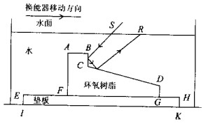
2002, 27(6): 780-782.
Abstract:
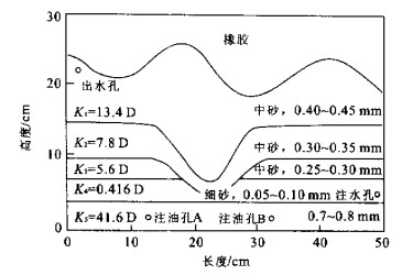
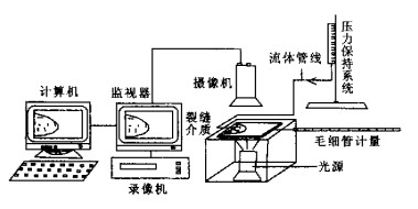
Physical modeling is an effective way to clarify the efficiency, process and mechanism of secondary oil migration and accumulation. Based on the deltaic front sandstone, which favors oil and gas pool forming, this paper designs and constructs a physical model of secondary oil migration and accumulation in finger-shape non-homogeneous reservoirs, which are composed of multi-layers of homogeneous reservoir, in order to research the path, efficiency and rate. The results of the experiment indicated that the path of secondary oil migration is quite limited. When oil entered into the reservoir from the tip position of finger-shape sandstone body, it mainly migrated to the trap along the middle finite path (about 5 cm wide) from its source. When the rate of migration was very fast, about 1.4 cm/min, and the saturation in the path was about 16%, and after it got to the seal layer, oil began to be accumulated. This implies that secondary oil migration and accumulation take on the characteristics along the finite path, fast and efficient migration and accumulation, and also reveals the "highway" of secondary oil migration exists and the rule of oil pool forming is synchronized with oil volume expelling.
Physical modeling is an effective way to clarify the efficiency, process and mechanism of secondary oil migration and accumulation. Based on the deltaic front sandstone, which favors oil and gas pool forming, this paper designs and constructs a physical model of secondary oil migration and accumulation in finger-shape non-homogeneous reservoirs, which are composed of multi-layers of homogeneous reservoir, in order to research the path, efficiency and rate. The results of the experiment indicated that the path of secondary oil migration is quite limited. When oil entered into the reservoir from the tip position of finger-shape sandstone body, it mainly migrated to the trap along the middle finite path (about 5 cm wide) from its source. When the rate of migration was very fast, about 1.4 cm/min, and the saturation in the path was about 16%, and after it got to the seal layer, oil began to be accumulated. This implies that secondary oil migration and accumulation take on the characteristics along the finite path, fast and efficient migration and accumulation, and also reveals the "highway" of secondary oil migration exists and the rule of oil pool forming is synchronized with oil volume expelling.