2005 Vol. 30, No. 5
Display Method:
2005, 30(5): 513-518.
 PDF 734KB
Abstract:
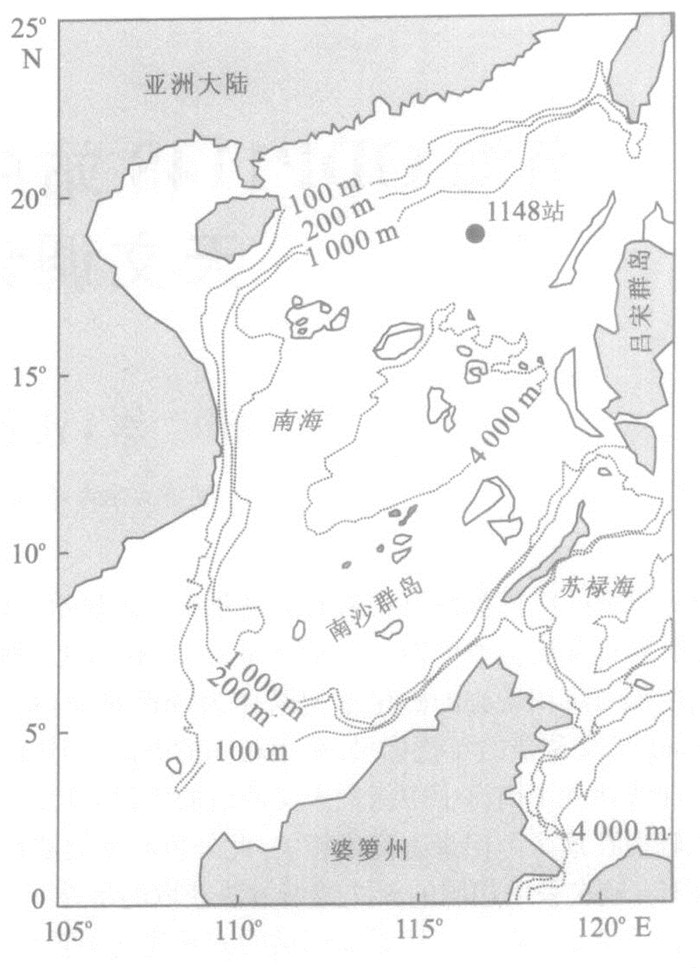
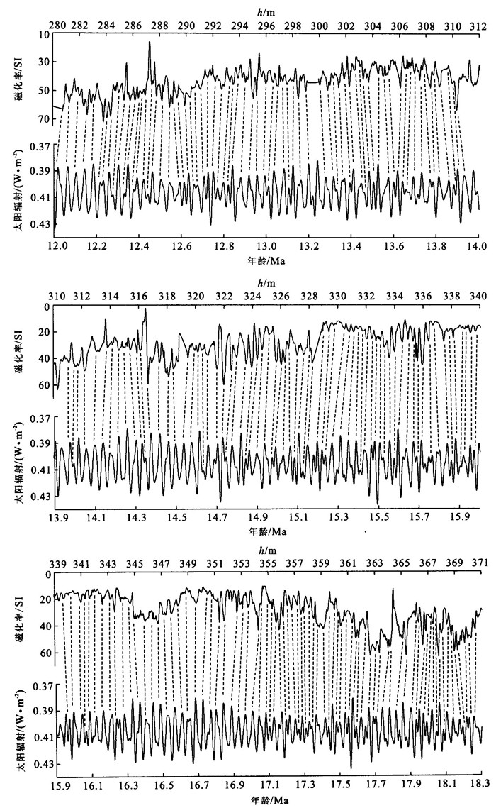
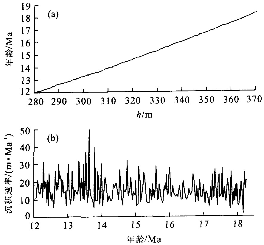
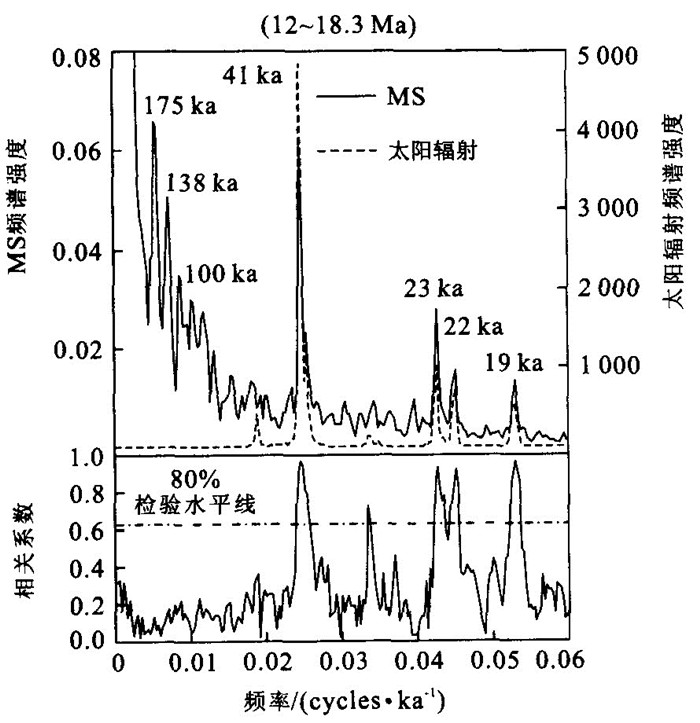
Lithological cyclicity was observed in magnetic susceptibility records of the deep sea sediments from ODP Site 1184 in the northern South China Sea (SCS), which was considered to be related to obliquity cycles in the Miocene and Oligocene. Using recent methodology, an astronomically tuned time scale for the middle Miocene of ODP Site 1148 in the northern SCS was established. After tuning, the magnetic susceptibility (MS) records show strong obliquity and precession cycles as well as prominent eccentricity cycles. The planktonic foraminiferal events identified within the studied interval of ODP Site 1148 show ages very close to those set by Shackleton et al. (1999) for ODP Leg 154, which were obtained by the same astronomical tuning method as this study, but differ substantially from the traditional age. The results lend support to the practicality of the method for establishing a tuned Miocene time scale.
Lithological cyclicity was observed in magnetic susceptibility records of the deep sea sediments from ODP Site 1184 in the northern South China Sea (SCS), which was considered to be related to obliquity cycles in the Miocene and Oligocene. Using recent methodology, an astronomically tuned time scale for the middle Miocene of ODP Site 1148 in the northern SCS was established. After tuning, the magnetic susceptibility (MS) records show strong obliquity and precession cycles as well as prominent eccentricity cycles. The planktonic foraminiferal events identified within the studied interval of ODP Site 1148 show ages very close to those set by Shackleton et al. (1999) for ODP Leg 154, which were obtained by the same astronomical tuning method as this study, but differ substantially from the traditional age. The results lend support to the practicality of the method for establishing a tuned Miocene time scale.
2005, 30(5): 519-528.
Abstract:
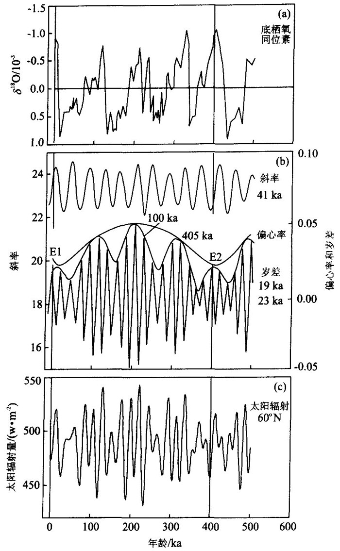
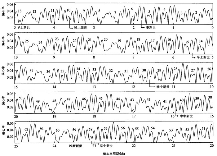
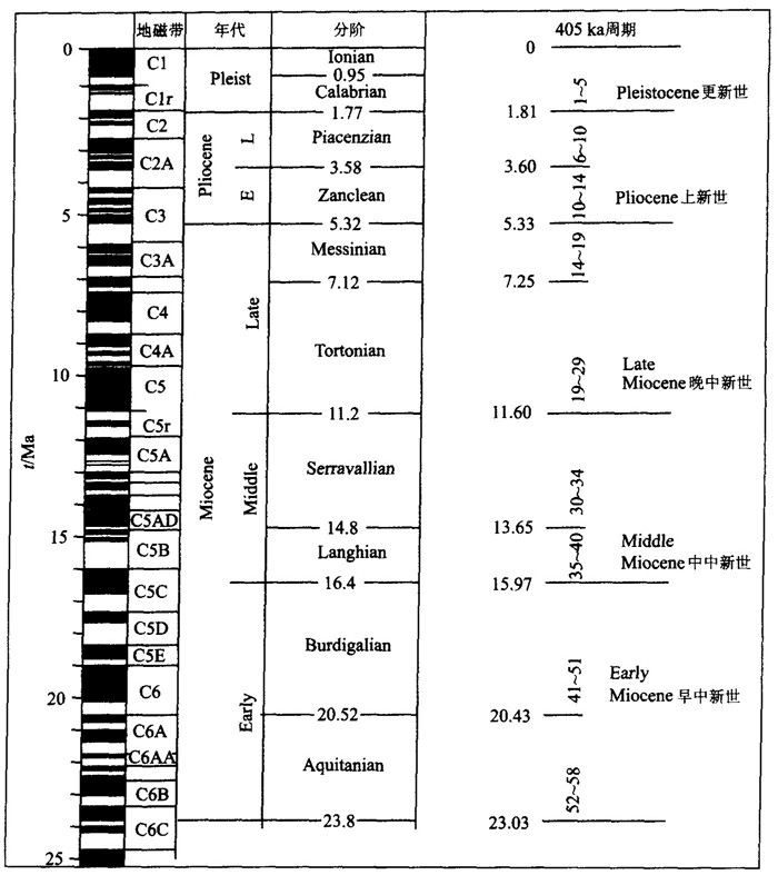
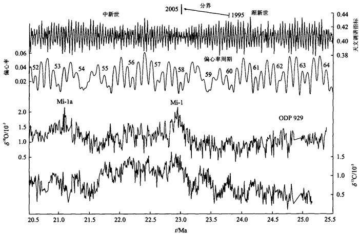
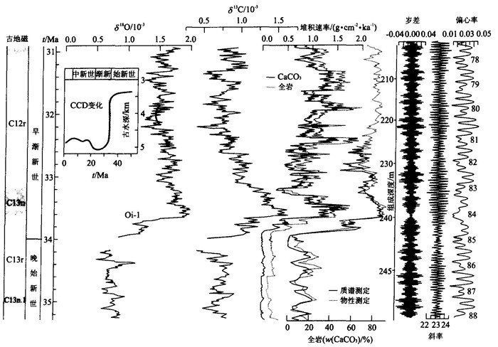
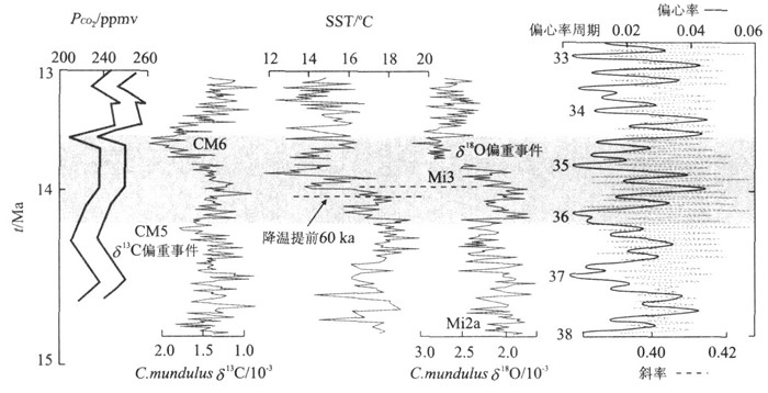
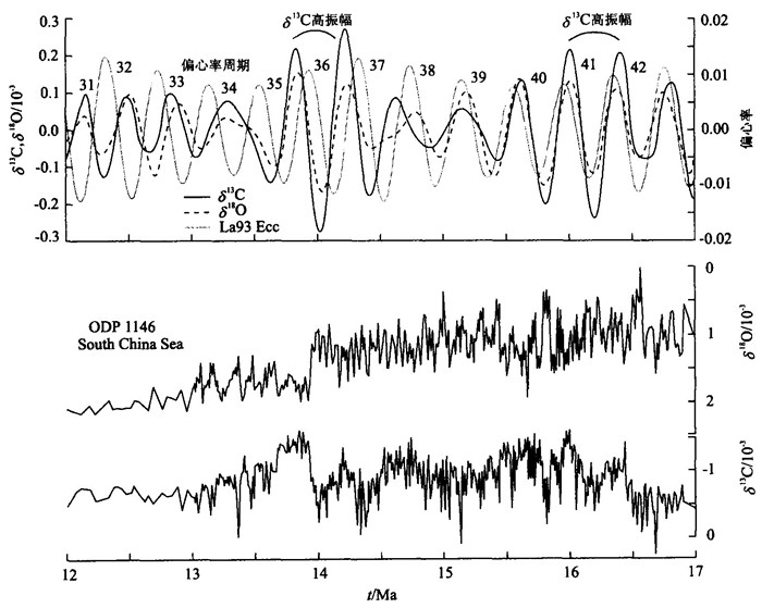
This paper introduces some new developments concerning orbital eccentricity in stratigraphic and paleoclimatic studies. The less than 0.2% error in calculating the current orbital model for the last 250 Ma makes possible stratigraphic subdivisions based upon eccentricity cycles. The newly erected international standard chronostratigraphic timescale uses the 405 ka long eccentricity cycles for separating major stratigraphic boundaries, and the Cenozoic Era now comprises E1 to E162 long eccentricity cycles, with the base dated at (65.5±0.3) Ma. The 100 ka and 405 ka eccentricity cycles have been found in many geological records, especially those paleoclimate proxies based upon physiochemical records from deep-sea drilling cores. Many important paleoclimatic events appear to have concurred with weak amplitude periods over the eccentricity band, indicating these periods were likely prone to the influence of such factors as the global carbon reservoir, ice caps, sea level and electromagnetic field, as well as regional tectonic reconfigurations. More and more studies show that the δ13C record is mainly related to orbital forcing over the eccentricity cycles, and its changes often precede δ18O changes, supporting the hypothesis that the carbon cycle is one of the key factors influencing the earth's climate.
This paper introduces some new developments concerning orbital eccentricity in stratigraphic and paleoclimatic studies. The less than 0.2% error in calculating the current orbital model for the last 250 Ma makes possible stratigraphic subdivisions based upon eccentricity cycles. The newly erected international standard chronostratigraphic timescale uses the 405 ka long eccentricity cycles for separating major stratigraphic boundaries, and the Cenozoic Era now comprises E1 to E162 long eccentricity cycles, with the base dated at (65.5±0.3) Ma. The 100 ka and 405 ka eccentricity cycles have been found in many geological records, especially those paleoclimate proxies based upon physiochemical records from deep-sea drilling cores. Many important paleoclimatic events appear to have concurred with weak amplitude periods over the eccentricity band, indicating these periods were likely prone to the influence of such factors as the global carbon reservoir, ice caps, sea level and electromagnetic field, as well as regional tectonic reconfigurations. More and more studies show that the δ13C record is mainly related to orbital forcing over the eccentricity cycles, and its changes often precede δ18O changes, supporting the hypothesis that the carbon cycle is one of the key factors influencing the earth's climate.
2005, 30(5): 529-533.
Abstract:
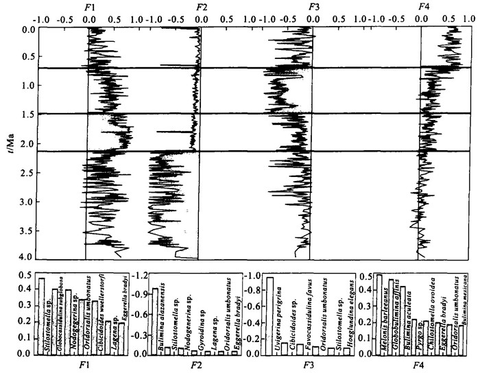
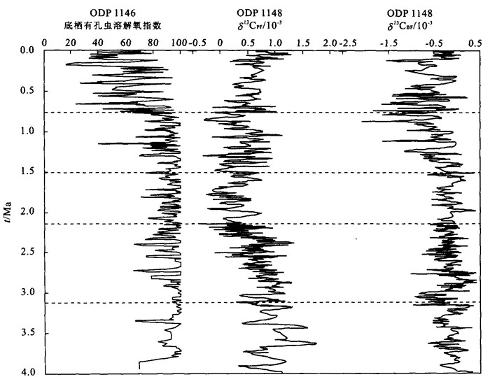
Through the Q-mode factor analysis of benthic foraminifera from ODP Site 1146 in the northern South China Sea since 4 Ma, we identified four assemblages of benthic foraminifera. These are the Stilostomella-Globocassidulina subglobosa-Nodogenerina assemblage, the Bulimina alazanensis assemblage, the Uvigerina perigrina assemblage, and the Melonis barleeanus-Globobulimina affinis-Bulimina aculeata assemblage, divided respectively at 2.1 Ma, 1.5 Ma and 0.7 Ma. Combined with the results of the benthic foraminiferal oxygen index (BFOI) and carbon isotopes of planktonic and benthic foraminifera, we consider that the variations in the benthic foraminiferal assemblages in the area were mainly controlled by nutrient changes in surface and bottom waters.
Through the Q-mode factor analysis of benthic foraminifera from ODP Site 1146 in the northern South China Sea since 4 Ma, we identified four assemblages of benthic foraminifera. These are the Stilostomella-Globocassidulina subglobosa-Nodogenerina assemblage, the Bulimina alazanensis assemblage, the Uvigerina perigrina assemblage, and the Melonis barleeanus-Globobulimina affinis-Bulimina aculeata assemblage, divided respectively at 2.1 Ma, 1.5 Ma and 0.7 Ma. Combined with the results of the benthic foraminiferal oxygen index (BFOI) and carbon isotopes of planktonic and benthic foraminifera, we consider that the variations in the benthic foraminiferal assemblages in the area were mainly controlled by nutrient changes in surface and bottom waters.
2005, 30(5): 534-542.
Abstract:
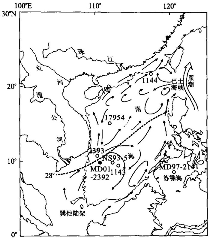
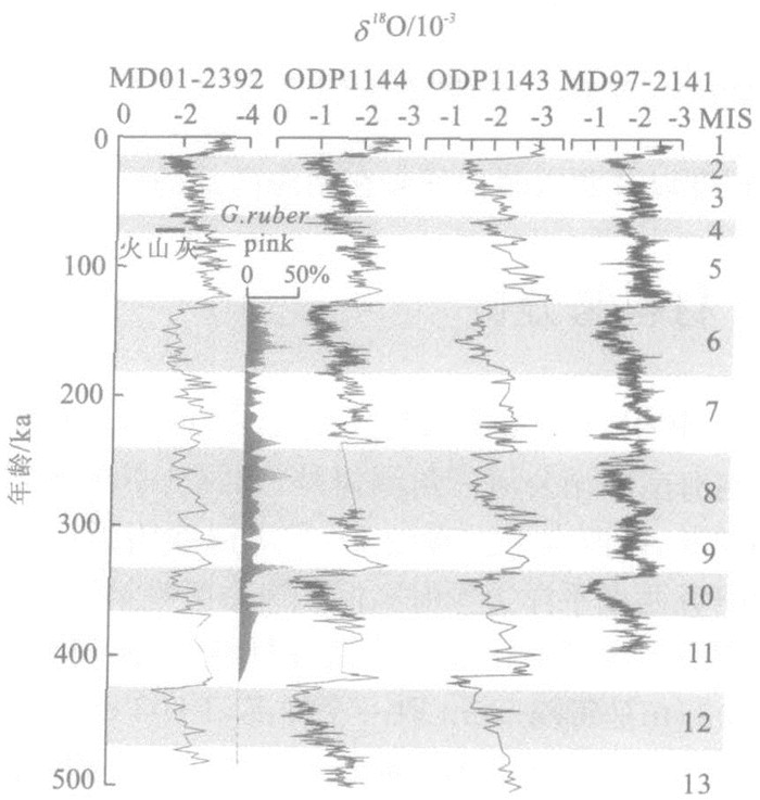
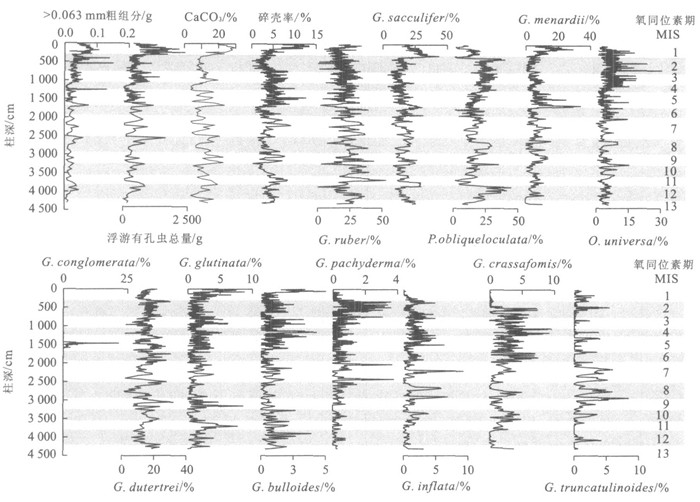
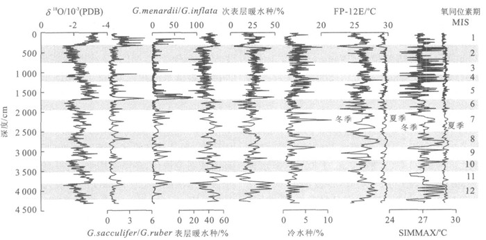
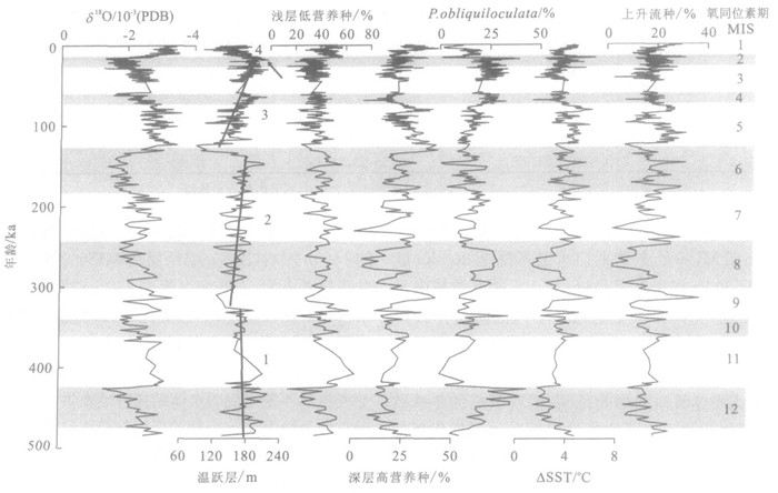
Planktonic foraminifera from IMAGES core MD01-2392 near the mouth of the Mekong River were quantitatively studied. Together with SST and thermocline analyses, the faunal results reveal major evolutionary paleoceanographic characteristics in the southwestern South China Sea over the last 500 ka. A higher winter SST was found for glacial periods, especially MIS12, MIS8 and MIS2-4, while interglacials including MIS9, MIS5 and MIS1 with a relatively low SST were documented. As marked by a high abundance of the nutrient-loving, deep dwelling species, the thermocline reached its shallowest depths during MIS5 and MIS1, followed by MIS9, indicating that the estimated low SST for interglacials was due to stronger upwelling. The relatively low estimated SST, however, may also have been influenced by low salinity due to frequent and stronger rainfall during interglacials which was not considered in the SST calculation. The relatively high winter SST during glacial periods favored the prolific growth of Pulleniatina obliquiloculata, a subsurface species preferring warm and saline environments. This implies that during glacial periods, upwelling in the southern South China Sea was suppressed by a winter monsoon flowing from the north, and water exchange weakened substantially because inter-basin passages were shut down during sea level lowstands and the possible development of a freshwater cap, subsequently leading to stronger stratification in the upper water column and the retention of a relatively warmer SST during glacial winters. The main reason why the response of planktonic foraminifera to Late Pleistocene glacial cycles in the southern South China Sea differs from the northern part and open oceans is likely to be because of the semi-enclosed sea basin and monsoon variability during glacial periods.
Planktonic foraminifera from IMAGES core MD01-2392 near the mouth of the Mekong River were quantitatively studied. Together with SST and thermocline analyses, the faunal results reveal major evolutionary paleoceanographic characteristics in the southwestern South China Sea over the last 500 ka. A higher winter SST was found for glacial periods, especially MIS12, MIS8 and MIS2-4, while interglacials including MIS9, MIS5 and MIS1 with a relatively low SST were documented. As marked by a high abundance of the nutrient-loving, deep dwelling species, the thermocline reached its shallowest depths during MIS5 and MIS1, followed by MIS9, indicating that the estimated low SST for interglacials was due to stronger upwelling. The relatively low estimated SST, however, may also have been influenced by low salinity due to frequent and stronger rainfall during interglacials which was not considered in the SST calculation. The relatively high winter SST during glacial periods favored the prolific growth of Pulleniatina obliquiloculata, a subsurface species preferring warm and saline environments. This implies that during glacial periods, upwelling in the southern South China Sea was suppressed by a winter monsoon flowing from the north, and water exchange weakened substantially because inter-basin passages were shut down during sea level lowstands and the possible development of a freshwater cap, subsequently leading to stronger stratification in the upper water column and the retention of a relatively warmer SST during glacial winters. The main reason why the response of planktonic foraminifera to Late Pleistocene glacial cycles in the southern South China Sea differs from the northern part and open oceans is likely to be because of the semi-enclosed sea basin and monsoon variability during glacial periods.
2005, 30(5): 543-549.
Abstract:
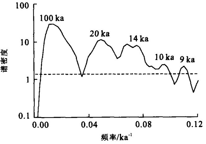
The East Asian monsoon (EAM) is an integral part of the global climatic system. Comparison between marine and terrestrial records can improve our knowledge of the monsoon system and how it responds to changing global conditions. In this paper, reflectance spectroscopy analysis is used to characterize the sediments in core 17954, taken from the South China Sea and representing the past 220 ka. The results show that sediment brightness (factor 1) seems to reflect carbonate contents and its changes are similar to the benthic oxygen isotope. Sediment redness (factor 2), which is related to iron oxide content, seems to monitor paleoclimatic changes in the core. Iron oxide appears to be eroded from catchments and is transported by fluvial means into the SCS. Thus, redness increases (factor 2 decreases) at times of increased precipitation, that is, as monsoon strength increases. Our results indicate that the Monsoon Termination Ⅱ occurred at ca. 129 ka based on orbital chronology. Two abnormally strong summer events occurred at the intervals just before the last two terminations, which are confirmed by other records around the world. A time series anlaysis of the factor 2 record indicates a half-precession frequency, which may correlate with the abnormally strong summer monsoon events, suggesting that the tropical ocean had a major effect on the East Asian summer monsoon.
The East Asian monsoon (EAM) is an integral part of the global climatic system. Comparison between marine and terrestrial records can improve our knowledge of the monsoon system and how it responds to changing global conditions. In this paper, reflectance spectroscopy analysis is used to characterize the sediments in core 17954, taken from the South China Sea and representing the past 220 ka. The results show that sediment brightness (factor 1) seems to reflect carbonate contents and its changes are similar to the benthic oxygen isotope. Sediment redness (factor 2), which is related to iron oxide content, seems to monitor paleoclimatic changes in the core. Iron oxide appears to be eroded from catchments and is transported by fluvial means into the SCS. Thus, redness increases (factor 2 decreases) at times of increased precipitation, that is, as monsoon strength increases. Our results indicate that the Monsoon Termination Ⅱ occurred at ca. 129 ka based on orbital chronology. Two abnormally strong summer events occurred at the intervals just before the last two terminations, which are confirmed by other records around the world. A time series anlaysis of the factor 2 record indicates a half-precession frequency, which may correlate with the abnormally strong summer monsoon events, suggesting that the tropical ocean had a major effect on the East Asian summer monsoon.


2005, 30(5): 550-558.
Abstract:
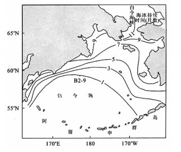
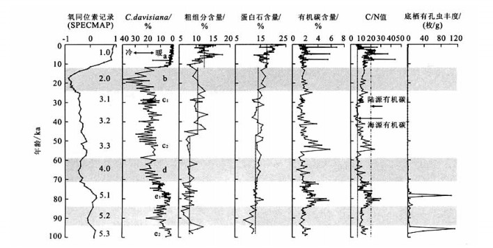
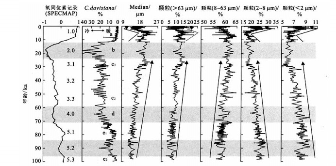
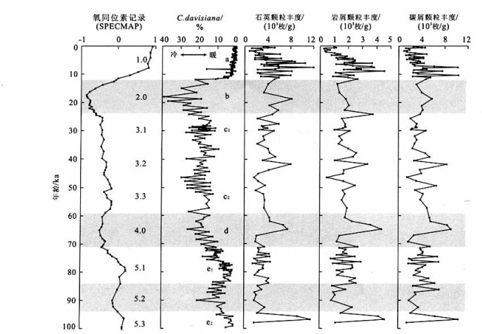
Quantitative analytic results of biogenic components in core B2-9 from the northern Bering Sea slope indicate that coarse fraction and opal content, serving as proxies of surface productivity, have increased stepwise since the MIS 5.3, reflecting periodic enhancement in surface productivity. Surface productivity attained its highest level during the Holocene, followed by MIS 3.2 to 2. MIS 5.3 to 3.3 showed the lowest level. High TOC content, together with a high C/N ratio, shows that TOC was deposited from mixed sources and therefore can not be used as a proxy of surface productivity. But high TOC and C/N ratio during MIS 5.1, 3.3 to 3.2 and the Holocene reflect that the terrigenous organic matter input increased during interglacial periods. Increases in fine-and silt-grained terrigenous components from MIS 5.3 to the Middle Holocene imply that sea ice on the Bering Sea slope extended continuously in a cooling climate. Ice-rafted (> 0.154 mm quartz and lithic grains) and charcoal detritus increased during glacial, interstadial and the last deglaciation periods, and decreased during interglacial periods, suggesting that sea ice volume on the slope extended and melted, respectively, during glacial and interglacial periods. The extension of sea ice during glacial periods was linked with the climate over North American continent, revealing the responses of sea ice extension in the Bering Sea to global climate change during Late Quaternary glacial and interglacial cycles.
Quantitative analytic results of biogenic components in core B2-9 from the northern Bering Sea slope indicate that coarse fraction and opal content, serving as proxies of surface productivity, have increased stepwise since the MIS 5.3, reflecting periodic enhancement in surface productivity. Surface productivity attained its highest level during the Holocene, followed by MIS 3.2 to 2. MIS 5.3 to 3.3 showed the lowest level. High TOC content, together with a high C/N ratio, shows that TOC was deposited from mixed sources and therefore can not be used as a proxy of surface productivity. But high TOC and C/N ratio during MIS 5.1, 3.3 to 3.2 and the Holocene reflect that the terrigenous organic matter input increased during interglacial periods. Increases in fine-and silt-grained terrigenous components from MIS 5.3 to the Middle Holocene imply that sea ice on the Bering Sea slope extended continuously in a cooling climate. Ice-rafted (> 0.154 mm quartz and lithic grains) and charcoal detritus increased during glacial, interstadial and the last deglaciation periods, and decreased during interglacial periods, suggesting that sea ice volume on the slope extended and melted, respectively, during glacial and interglacial periods. The extension of sea ice during glacial periods was linked with the climate over North American continent, revealing the responses of sea ice extension in the Bering Sea to global climate change during Late Quaternary glacial and interglacial cycles.
2005, 30(5): 559-564+603.
Abstract:
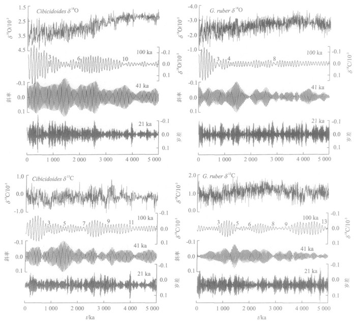
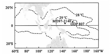
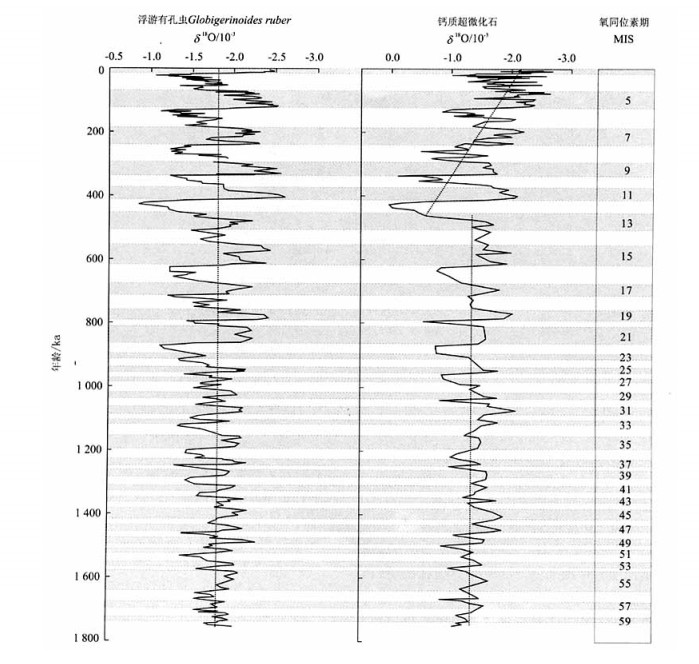
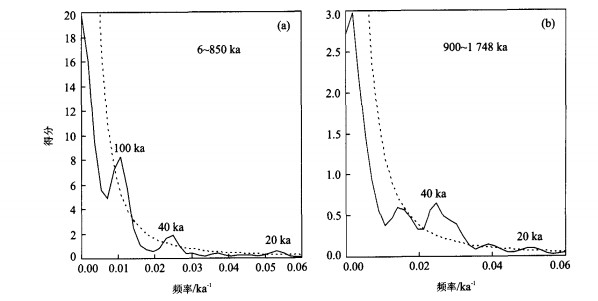
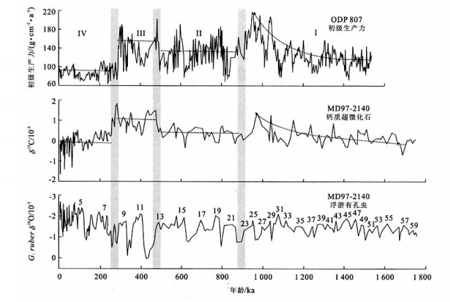
Oxygen and carbon isotopic analyses have been carried out on calcareous nannofossils from core MD97-2140 in the Western Pacific warm pool. The results demonstrate that the δ18O values of calcareous nannofossils for the past 1.75 Ma vary systematically with δ18O values of planktonic foraminifer Globigerinoides ruber from the same core. The δ18O records of calcareous nannofossils show a dominant 41 ka peak between 1 478 and 900 ka and a 100 ka peak between 850 and 6 ka, and 59 isotope stages can be recognized. The similarity between δ18O records of planktonic foraminifera and nannofossils implies that calcareous nannofossil δ18O can also play an important role in stratigraphic and palaeoceanographic studies. The δ13C records of nannofossils can be divided into four major stages respectively at the boundaries 900 ka, 480 ka and 250 ka. The trends of the nannofossil δ13C records from MD97-2140 are similar to primary productivity variations at ODP site 807, also located in the Western Pacific warm pool, indicating that nannofossil δ13C can be used as an indicator of sea surface palaeoproductivity.
Oxygen and carbon isotopic analyses have been carried out on calcareous nannofossils from core MD97-2140 in the Western Pacific warm pool. The results demonstrate that the δ18O values of calcareous nannofossils for the past 1.75 Ma vary systematically with δ18O values of planktonic foraminifer Globigerinoides ruber from the same core. The δ18O records of calcareous nannofossils show a dominant 41 ka peak between 1 478 and 900 ka and a 100 ka peak between 850 and 6 ka, and 59 isotope stages can be recognized. The similarity between δ18O records of planktonic foraminifera and nannofossils implies that calcareous nannofossil δ18O can also play an important role in stratigraphic and palaeoceanographic studies. The δ13C records of nannofossils can be divided into four major stages respectively at the boundaries 900 ka, 480 ka and 250 ka. The trends of the nannofossil δ13C records from MD97-2140 are similar to primary productivity variations at ODP site 807, also located in the Western Pacific warm pool, indicating that nannofossil δ13C can be used as an indicator of sea surface palaeoproductivity.
2005, 30(5): 565-572.
Abstract:
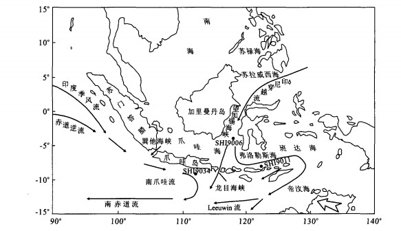
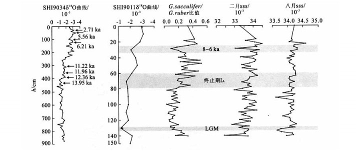
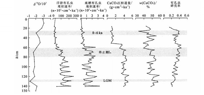
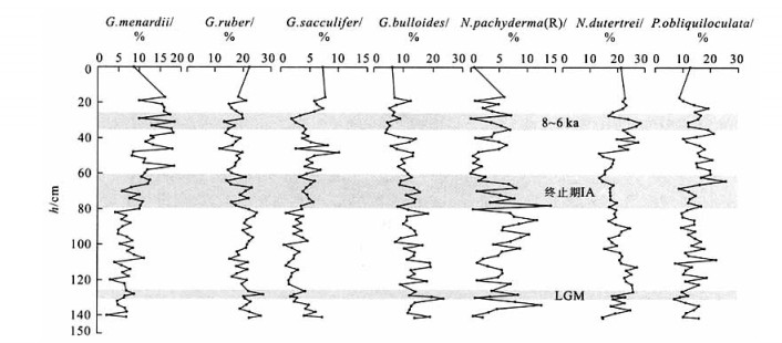
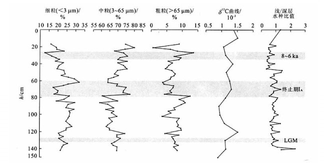
The Flores Sea is situated in the path of the Indonesian throughflow. Its paleoceanographical characteristic is very important for us to understand the throughflow actions during the last glacial maximum, and the relationship between the throughflow and global climate changes. Based on the study of the paleoceanographical record δ18O, δ13C, planktonic foraminifer assemblage and CaCO3 relation abundance of the core SHI9011 from the Flores Sea, the results are following: the sediment rate in the studied region was not high, but the productivity was not lower than the region nearby the land where sediment rate was high. The sea level dropped in the glacial, the mass of the terrigenous sediment increased, so that the paleoproductivity ascended. The sea level rose rapidly in the deglaciation termination, the terrigenous nutrition decreased, and the throughflow action enhanced, restraining the upwelling of the down water, the paleoproductivity descended. In around 8-6 ka, due to the strong southeast monsoon action, the upwelling action enhanced in the studied region.
The Flores Sea is situated in the path of the Indonesian throughflow. Its paleoceanographical characteristic is very important for us to understand the throughflow actions during the last glacial maximum, and the relationship between the throughflow and global climate changes. Based on the study of the paleoceanographical record δ18O, δ13C, planktonic foraminifer assemblage and CaCO3 relation abundance of the core SHI9011 from the Flores Sea, the results are following: the sediment rate in the studied region was not high, but the productivity was not lower than the region nearby the land where sediment rate was high. The sea level dropped in the glacial, the mass of the terrigenous sediment increased, so that the paleoproductivity ascended. The sea level rose rapidly in the deglaciation termination, the terrigenous nutrition decreased, and the throughflow action enhanced, restraining the upwelling of the down water, the paleoproductivity descended. In around 8-6 ka, due to the strong southeast monsoon action, the upwelling action enhanced in the studied region.
2005, 30(5): 573-581.
Abstract:
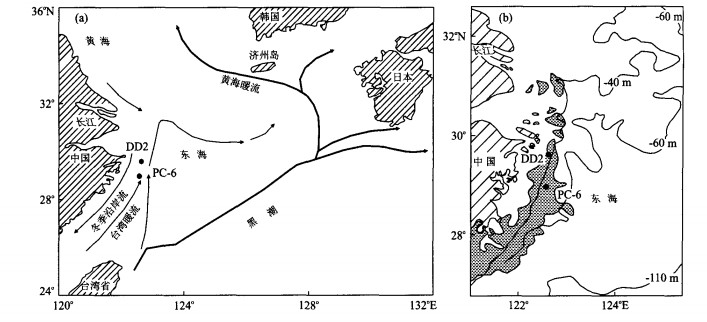
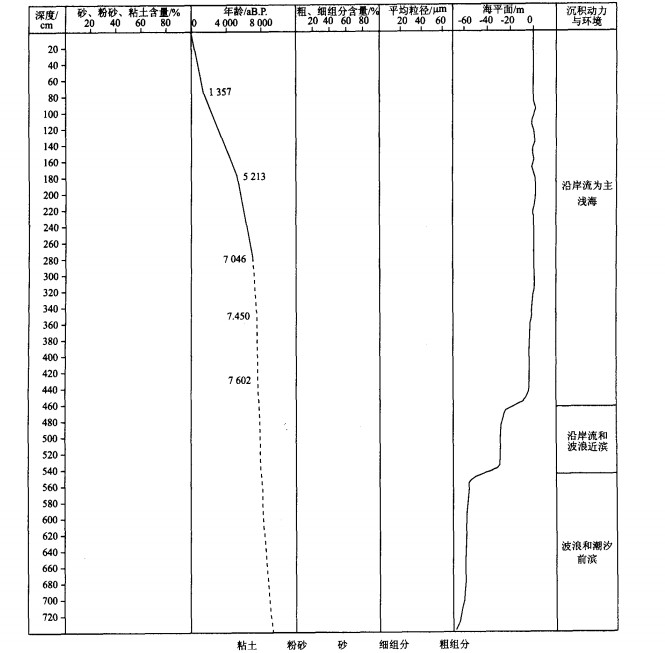
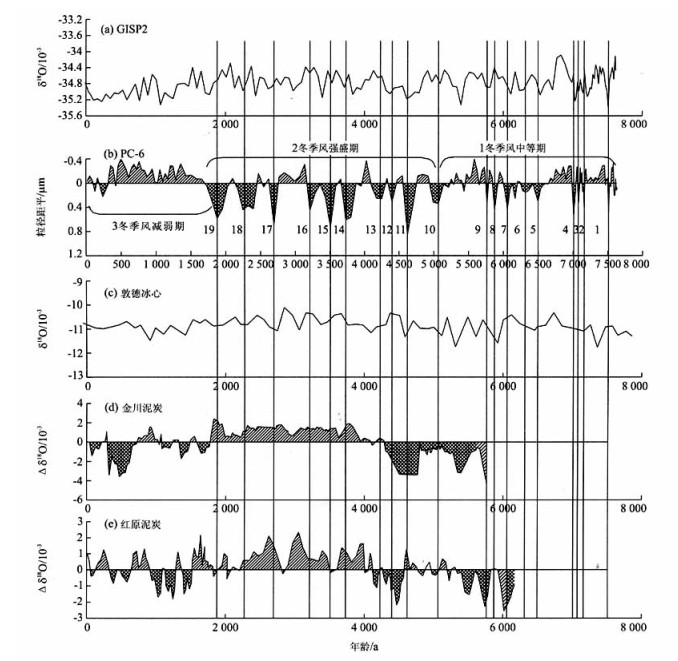
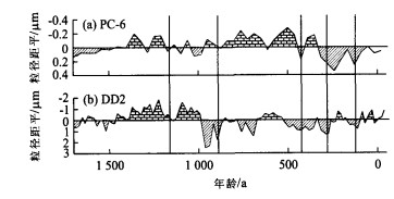
High resolution proxy and record of the Holocene East Asian monsoon is presented based on AMS 14 C dating and grain-size analysis from Core PC-6, located in the middle of the Yangtze River-derived mud off the Zhejiang-Fujian coasts on the inner shelf of the East China Sea (ECS). The sedimentary environments of its upper, middle and lower sections are foreshore, nearshore and shallow sea, similar to the present. The sedimentation of the upper section is controlled by the ECS Winter Coast Current, and corresponding grain-size subpopulation is identified by using grain-size vs. standard deviation. The mean grain-size of the subpopulation is used as a proxy of the East Asian winter monsoon (EAWM), and a recent 8 ka grain-size time series is established to study the evolution of the EAWM. The series showing 3 characteristic sections of the EAWM: moderate and high fluctuation frequency during 7.6-5.1 kaB.P.; much strengthened during 5.1-1.7 kaB.P.; and relatively stable and weakened during 1.7-0 kaB.P.. Periods of the strengthened winter monsoon indicated by PC-6 are all corroborated by other proxies in various areas, which show that regional and even global relationships of climate change exist.
High resolution proxy and record of the Holocene East Asian monsoon is presented based on AMS 14 C dating and grain-size analysis from Core PC-6, located in the middle of the Yangtze River-derived mud off the Zhejiang-Fujian coasts on the inner shelf of the East China Sea (ECS). The sedimentary environments of its upper, middle and lower sections are foreshore, nearshore and shallow sea, similar to the present. The sedimentation of the upper section is controlled by the ECS Winter Coast Current, and corresponding grain-size subpopulation is identified by using grain-size vs. standard deviation. The mean grain-size of the subpopulation is used as a proxy of the East Asian winter monsoon (EAWM), and a recent 8 ka grain-size time series is established to study the evolution of the EAWM. The series showing 3 characteristic sections of the EAWM: moderate and high fluctuation frequency during 7.6-5.1 kaB.P.; much strengthened during 5.1-1.7 kaB.P.; and relatively stable and weakened during 1.7-0 kaB.P.. Periods of the strengthened winter monsoon indicated by PC-6 are all corroborated by other proxies in various areas, which show that regional and even global relationships of climate change exist.
2005, 30(5): 582-588.
Abstract:
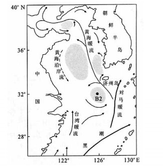
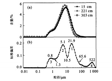
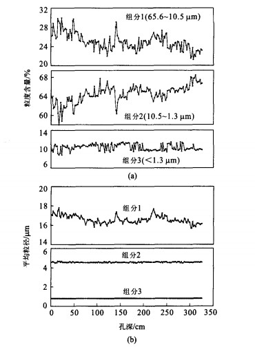
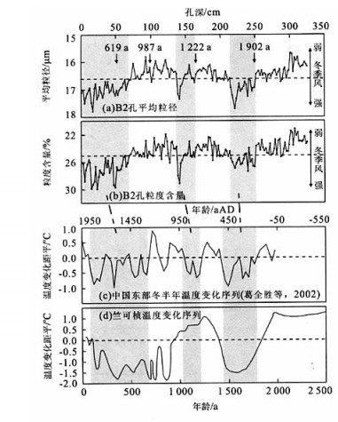
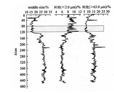
Grain-size analysis of sediment core B2, retrieved from mud area southwest off Cheju Island, East China Sea (ECS), was carried out using a Malvern 2000 grain-size analyzer. 4 grain-size components, > 65.6, 65.6-10.5, 10.5-1.3 and < 1.3 μm, can be easily identified according to variations in the grain-size standard deviation. Mainly containing benthic foraminifera, the coarse component (> 65.6 μm) has a very low content, and can be neglected. Downcore variations of the mean-size and content of the other 3 components show that the 65.6-10.5 mm component 1 is relatively high, 21%-30%, and fluctuates most strongly, suggesting it is the environmentally sensitive grain-size component (ESGSC) in core B2. The mean-size and content of ESGSC in the studied mud area appears to have been mainly controlled by variations in the strength of the East Asian winter monsoon, with high content and mean-size of ESGCS when the winter monsoon was strong. The winter monsoon variations reconstructed according to this relationship are consistent with climate series records from eastern China over the past 2 000 years, indicating that the grain-size component of 65.6-10.5 mm can be used as a proxy of the East Asian winter monsoon variation.
Grain-size analysis of sediment core B2, retrieved from mud area southwest off Cheju Island, East China Sea (ECS), was carried out using a Malvern 2000 grain-size analyzer. 4 grain-size components, > 65.6, 65.6-10.5, 10.5-1.3 and < 1.3 μm, can be easily identified according to variations in the grain-size standard deviation. Mainly containing benthic foraminifera, the coarse component (> 65.6 μm) has a very low content, and can be neglected. Downcore variations of the mean-size and content of the other 3 components show that the 65.6-10.5 mm component 1 is relatively high, 21%-30%, and fluctuates most strongly, suggesting it is the environmentally sensitive grain-size component (ESGSC) in core B2. The mean-size and content of ESGSC in the studied mud area appears to have been mainly controlled by variations in the strength of the East Asian winter monsoon, with high content and mean-size of ESGCS when the winter monsoon was strong. The winter monsoon variations reconstructed according to this relationship are consistent with climate series records from eastern China over the past 2 000 years, indicating that the grain-size component of 65.6-10.5 mm can be used as a proxy of the East Asian winter monsoon variation.
2005, 30(5): 589-596.
Abstract:
Dating paleosol and animal remains accurately and reliably is of crucial importance in reconstructing environmental change processes and researching the relationship between natural environments and human evolution. Dating different components in the same specimen and differentiating their ages is also important for tackling problems such as carbon storage state and soil carbon sources. Conventional 14C and AMS dating on animal remains (fossil bone and teeth) and inorganic and organic soil matter from a typical loess section at Xinglong Mountain, Yuzhong County, Gansu Province reveal that three different substances in the specimen from the same sampling position possess different 14C ages: the age of inorganic matter is 2 624 years older than that of organic matter, which is dated at (3 682±70) a. According to the reliability analysis of these 14C ages, laboratory error is negligible, but the 14C resources, the component of 14C and the proportion of "dead carbon" are the main factors influencing 14C dating results. It is only possible to date the geological events correctly and reliably by analyzing the reasons generating these differences and the age comparison of different substances may provide information on paleoclimate and paleoenvironment. A 2 000 year difference between the 14C ages of fossil and organic soil matter might indicate that a sediment gap exists, which is very important when reconstructing paleoclimate by loess section.
Dating paleosol and animal remains accurately and reliably is of crucial importance in reconstructing environmental change processes and researching the relationship between natural environments and human evolution. Dating different components in the same specimen and differentiating their ages is also important for tackling problems such as carbon storage state and soil carbon sources. Conventional 14C and AMS dating on animal remains (fossil bone and teeth) and inorganic and organic soil matter from a typical loess section at Xinglong Mountain, Yuzhong County, Gansu Province reveal that three different substances in the specimen from the same sampling position possess different 14C ages: the age of inorganic matter is 2 624 years older than that of organic matter, which is dated at (3 682±70) a. According to the reliability analysis of these 14C ages, laboratory error is negligible, but the 14C resources, the component of 14C and the proportion of "dead carbon" are the main factors influencing 14C dating results. It is only possible to date the geological events correctly and reliably by analyzing the reasons generating these differences and the age comparison of different substances may provide information on paleoclimate and paleoenvironment. A 2 000 year difference between the 14C ages of fossil and organic soil matter might indicate that a sediment gap exists, which is very important when reconstructing paleoclimate by loess section.
2005, 30(5): 597-603.
Abstract:
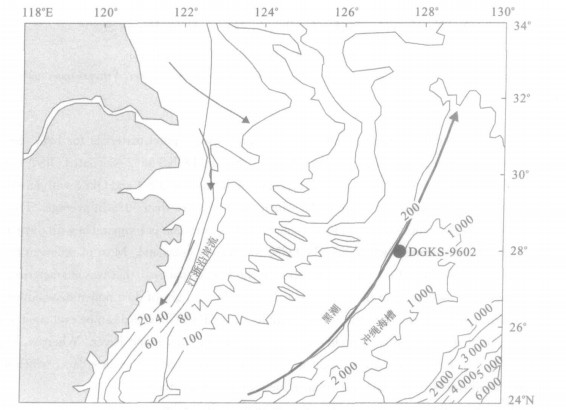
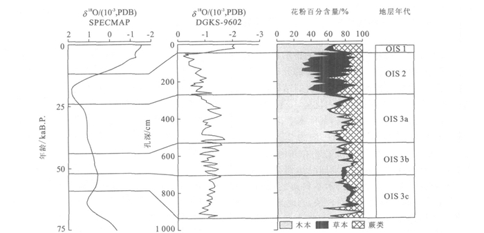
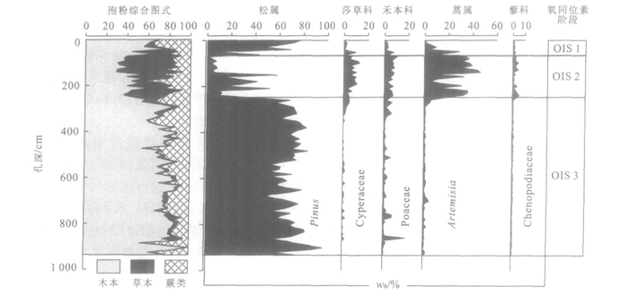
The high rate sedimentation in the west Okinawa Trough provides good materials for high resolution study on palaeoenvironment evolution. In comparing with SPECMAP curve, the core DGKS-9602 was dated OIS 3 to OIS 1 for a total length of 931 cm. Pollen analysis shows that Pinus was predominated during the OIS 1 and OIS 3 with an average percentage 65%, but it decreased at OIS 2, giving place to the herbs which attained more than 50% in average. This result suggests that the alternation of Pinus/herbs indicates the sea level changes and its variation is comparable with oxygen isotopic curve. The vegetation covered on the continental shelf during the LGM was mainly grassland. Most of sediment origin of the study core might be resulted from the erosion of the continental shelf of the East China Sea, that was characterized by the decrease of components from upriver and mountains in the pollen assemblages. In the light of dust pollen distribution pattern in eastern China, the ratio of Artemisia/Poaceae from the surface samples of the East China Sea can be evaluated to the corresponding latitude in the continent that coincided with middle and lower reach of Changjiang River. Whereas, the ratio obtained from the LGM in the core 9602 has an estimative result of 7 latitudes higher than the surface data, which indicates that the vegetation zones shifted southwards with amplitude comparable with previous studies.
The high rate sedimentation in the west Okinawa Trough provides good materials for high resolution study on palaeoenvironment evolution. In comparing with SPECMAP curve, the core DGKS-9602 was dated OIS 3 to OIS 1 for a total length of 931 cm. Pollen analysis shows that Pinus was predominated during the OIS 1 and OIS 3 with an average percentage 65%, but it decreased at OIS 2, giving place to the herbs which attained more than 50% in average. This result suggests that the alternation of Pinus/herbs indicates the sea level changes and its variation is comparable with oxygen isotopic curve. The vegetation covered on the continental shelf during the LGM was mainly grassland. Most of sediment origin of the study core might be resulted from the erosion of the continental shelf of the East China Sea, that was characterized by the decrease of components from upriver and mountains in the pollen assemblages. In the light of dust pollen distribution pattern in eastern China, the ratio of Artemisia/Poaceae from the surface samples of the East China Sea can be evaluated to the corresponding latitude in the continent that coincided with middle and lower reach of Changjiang River. Whereas, the ratio obtained from the LGM in the core 9602 has an estimative result of 7 latitudes higher than the surface data, which indicates that the vegetation zones shifted southwards with amplitude comparable with previous studies.
2005, 30(5): 604-608.
Abstract:
Saline sequences exist in the lower fourth number of the Shahejie Formation and the first number of the Kongdian Formation in the Dongying depression. The typical feature of primary sediments of the saline sequence is the rhythmic succession characterized by interbeds of evaporite and overpressured mudstone, which is prevalent in continental fault basins in China. As a whole, a salt-mud bed is different from a cure salt bed or mud bed and its plastic forming structures are also different. So the concepts of "salt-mud bed" and "salt-mud tectonics" are proposed in this paper. "salt-mud bed" refers to sedimentary sequence consisting of the interbeds of evaporite and overpressured mudstone, which has ductile or fluid properties. "salt-mud tectonics" is a kind of tectonics resulting from the distortion of a salt-mud bed flow. The concept of salt-mud bed will assist research into the genetic mechanism and structural style of salt-mud tectonics.
Saline sequences exist in the lower fourth number of the Shahejie Formation and the first number of the Kongdian Formation in the Dongying depression. The typical feature of primary sediments of the saline sequence is the rhythmic succession characterized by interbeds of evaporite and overpressured mudstone, which is prevalent in continental fault basins in China. As a whole, a salt-mud bed is different from a cure salt bed or mud bed and its plastic forming structures are also different. So the concepts of "salt-mud bed" and "salt-mud tectonics" are proposed in this paper. "salt-mud bed" refers to sedimentary sequence consisting of the interbeds of evaporite and overpressured mudstone, which has ductile or fluid properties. "salt-mud tectonics" is a kind of tectonics resulting from the distortion of a salt-mud bed flow. The concept of salt-mud bed will assist research into the genetic mechanism and structural style of salt-mud tectonics.
2005, 30(5): 609-616.
Abstract:
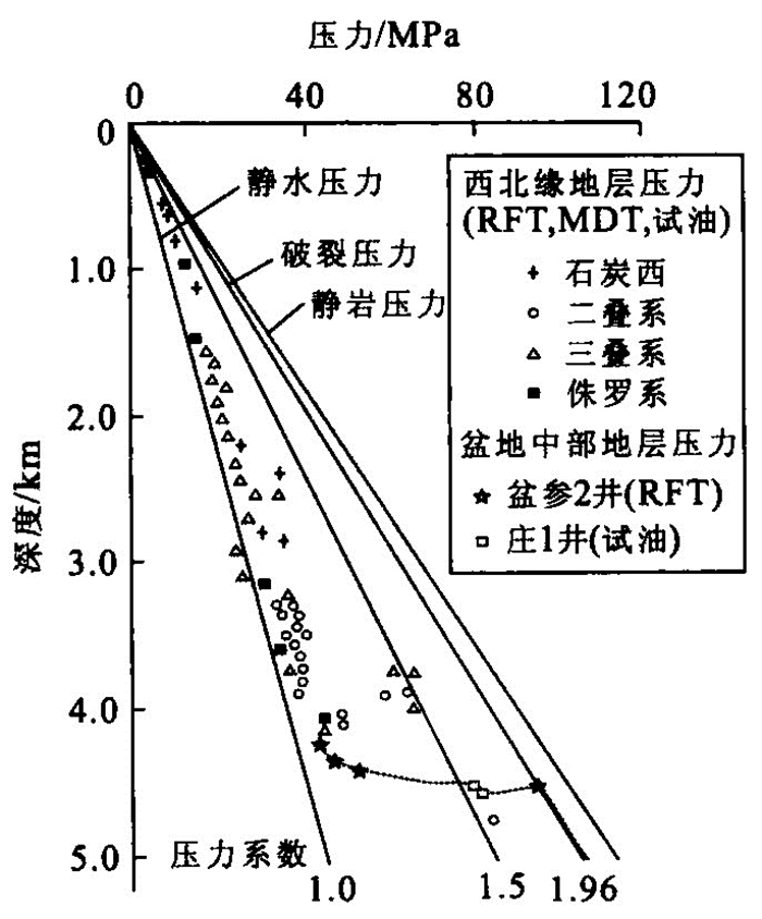
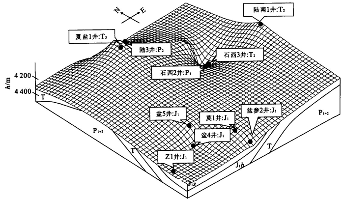
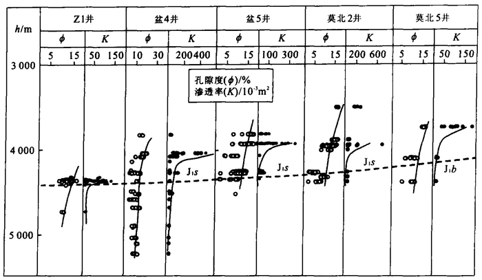
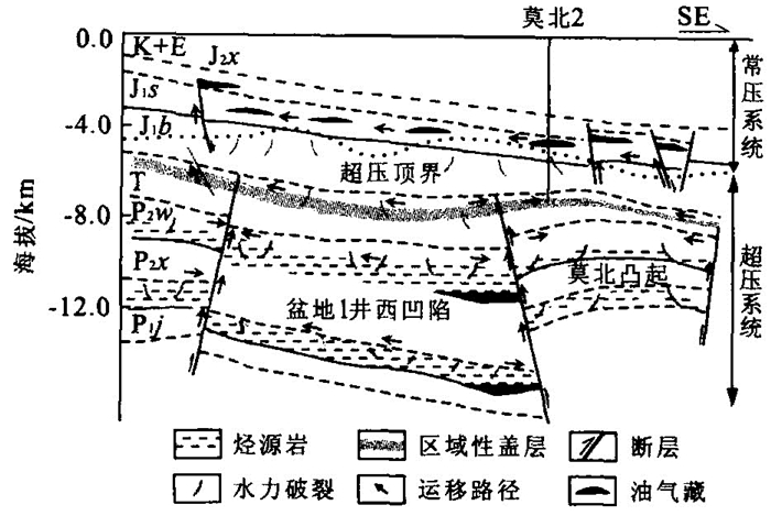
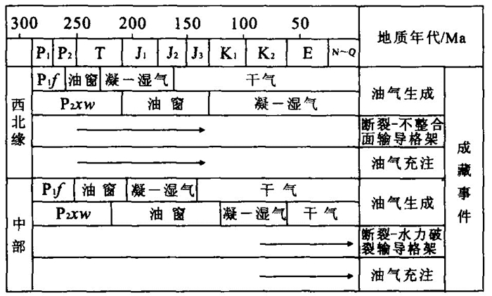
The Junggar basin is a huge, multiple-stage basin in Northwest China. Different structural units of this basin have quite different evolution histories, fluid-flow environments, fluid-conduit frameworks and petroleum accumulation histories. The northwest margin of the Junggar basin is in a normally pressured environment with a fault-unconformity conduit framework connecting source rocks and traps effectively. Due to the effectiveness of the fluid-conduit framework in this region, the major petroleum accumulation occurred almost at the same time as the main phase of oil generation. Very few faults developed in the center part of the Junggar basin, and faults in the shallow section could not connect with faults in the deeper section. As a result, petroleum generated in the Permian source rocks could not have migrated vertically into the overlying Jurassic reservoir rocks during the peak petroleum generation stage (Triassic to Jurassic) until the Cretaceous, when fracturing caused by overpressure occurred and the Jurassic reservoir rocks were connected with the Permian source rock by faults and hydraulic fractures. Because the fault-hydraulic fracturing and the resultant fault-fracture conduit framework developed a relatively long time after peak oil generation, the major petroleum accumulation came later than peak oil generation, and the accumulated oil had a relatively high maturity. This study confirms that in an overpressured environment the fluid-conduit framework is dynamic, and has a controlling effect on the petroleum migration pathway and accumulation intervals, as well as the injection histories.
The Junggar basin is a huge, multiple-stage basin in Northwest China. Different structural units of this basin have quite different evolution histories, fluid-flow environments, fluid-conduit frameworks and petroleum accumulation histories. The northwest margin of the Junggar basin is in a normally pressured environment with a fault-unconformity conduit framework connecting source rocks and traps effectively. Due to the effectiveness of the fluid-conduit framework in this region, the major petroleum accumulation occurred almost at the same time as the main phase of oil generation. Very few faults developed in the center part of the Junggar basin, and faults in the shallow section could not connect with faults in the deeper section. As a result, petroleum generated in the Permian source rocks could not have migrated vertically into the overlying Jurassic reservoir rocks during the peak petroleum generation stage (Triassic to Jurassic) until the Cretaceous, when fracturing caused by overpressure occurred and the Jurassic reservoir rocks were connected with the Permian source rock by faults and hydraulic fractures. Because the fault-hydraulic fracturing and the resultant fault-fracture conduit framework developed a relatively long time after peak oil generation, the major petroleum accumulation came later than peak oil generation, and the accumulated oil had a relatively high maturity. This study confirms that in an overpressured environment the fluid-conduit framework is dynamic, and has a controlling effect on the petroleum migration pathway and accumulation intervals, as well as the injection histories.

2005, 30(5): 617-622.
Abstract:
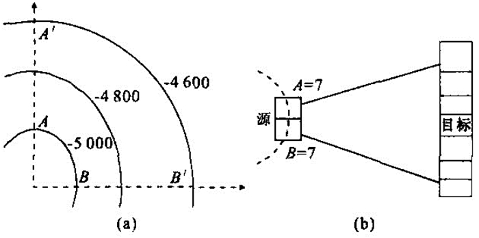
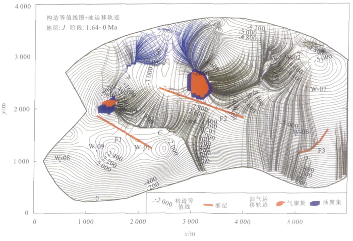
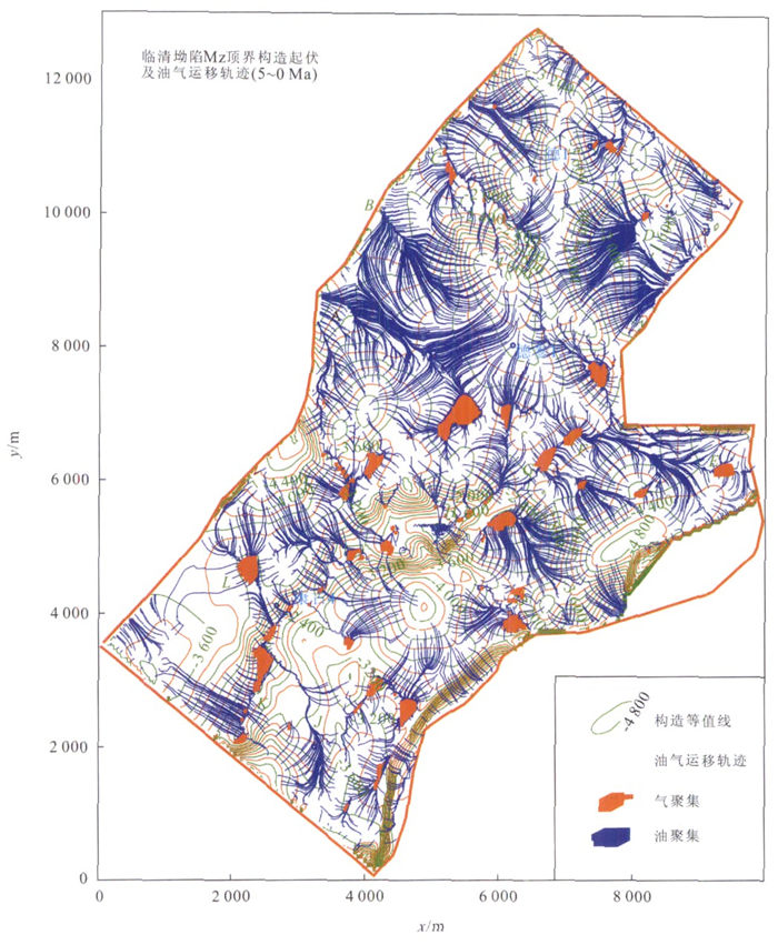
The process of reconstructing the migration and accumulation of hydrocarbon depends on the establishment of an effective dynamic model. There are limitations using the traditional method to simulate hydrocarbon migration and accumulation based on Darcy's Law. This paper adopts the flow path model, based on the buoyancy-drive, follows and calculates the trace of streamline of oil and gas. Generally acknowledged geological models of hydrocarbon movement and accumulation are here represented by new quantitative mathematical models. The dynamic filling process of hydrocarbon in a non-homogeneous layer was then simulated using these models. Based on the results of this modeling, the resources of oil and gas of plays can be evaluated, and a visible and intuitive analysis tool is provided for geologists to explain the main channel of hydrocarbon migration.
The process of reconstructing the migration and accumulation of hydrocarbon depends on the establishment of an effective dynamic model. There are limitations using the traditional method to simulate hydrocarbon migration and accumulation based on Darcy's Law. This paper adopts the flow path model, based on the buoyancy-drive, follows and calculates the trace of streamline of oil and gas. Generally acknowledged geological models of hydrocarbon movement and accumulation are here represented by new quantitative mathematical models. The dynamic filling process of hydrocarbon in a non-homogeneous layer was then simulated using these models. Based on the results of this modeling, the resources of oil and gas of plays can be evaluated, and a visible and intuitive analysis tool is provided for geologists to explain the main channel of hydrocarbon migration.
2005, 30(5): 623-634.
Abstract:
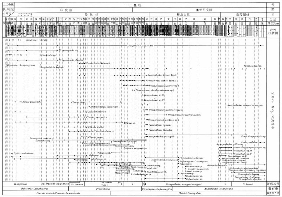
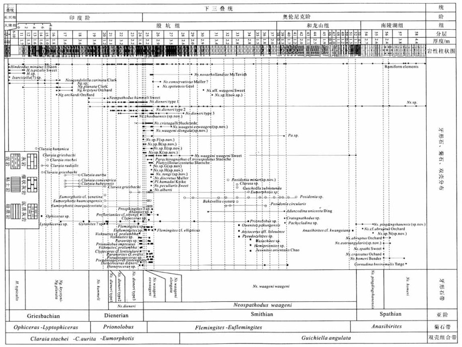
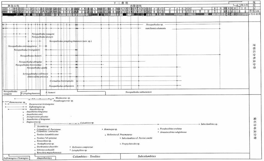
The paleogeographical setting of Chaohu during the Early Triassic was in the deep part of the Yangtze platform and the Lower Triassic sequence is complete throughout with rich and various fossils, especially distinct ammonoid and conodont biostratigraphic sequences, and it is one of the most typical sections of Early Triassic chronostratigraphy in the world. Lower Triassic conodont fossils were systematically collected from continuous sections of West Pingdingshan, North Pingdingshan and South Majiashan, Chaohu, Anhui Province on a sample-by-sample basis. Detailed zonations are made in each section. Eight conodont stratigraphic zones have been distinguished. They are, in ascending order, Hindeodus typicalis Zone, Neogondolella krystyni-Neogondolella planata Zone, Neospathodus kummeli Zone, and Neospathodus dieneri Zone, Neospathodus waageni Zone, Neospathodus pingdingshanensis Zone, Neospathodus homeri Zone, and Neospathodus anhuinensis Zone. They may be precisely correlated with contemporaneous ones in North America and other areas. These data are reliable evidence for erecting the global stratotype of the Induan-Olenekian boundary (GSSP).
The paleogeographical setting of Chaohu during the Early Triassic was in the deep part of the Yangtze platform and the Lower Triassic sequence is complete throughout with rich and various fossils, especially distinct ammonoid and conodont biostratigraphic sequences, and it is one of the most typical sections of Early Triassic chronostratigraphy in the world. Lower Triassic conodont fossils were systematically collected from continuous sections of West Pingdingshan, North Pingdingshan and South Majiashan, Chaohu, Anhui Province on a sample-by-sample basis. Detailed zonations are made in each section. Eight conodont stratigraphic zones have been distinguished. They are, in ascending order, Hindeodus typicalis Zone, Neogondolella krystyni-Neogondolella planata Zone, Neospathodus kummeli Zone, and Neospathodus dieneri Zone, Neospathodus waageni Zone, Neospathodus pingdingshanensis Zone, Neospathodus homeri Zone, and Neospathodus anhuinensis Zone. They may be precisely correlated with contemporaneous ones in North America and other areas. These data are reliable evidence for erecting the global stratotype of the Induan-Olenekian boundary (GSSP).
2005, 30(5): 635-638.
Abstract:
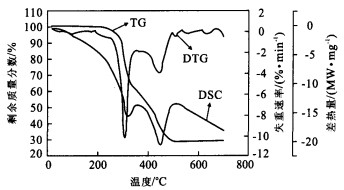
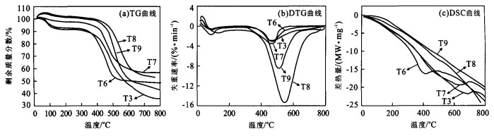
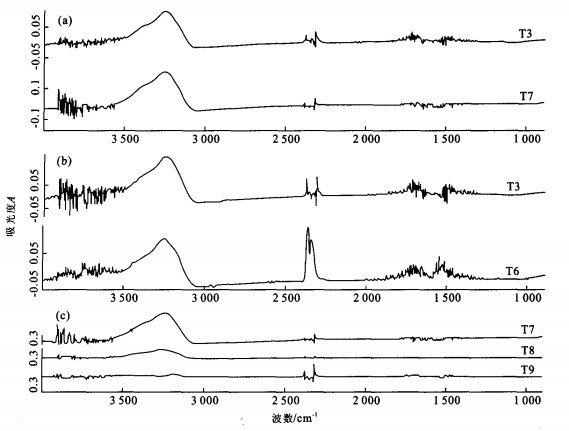
The understanding of the mechanism of activated carbon prepared from cellulose residues from the acid hydrolysis of Discorea zingiberensis C.H.Wright may help us to investigate systematically, with the help of TG-FTIR, the pyrolysis of the carbonization with ZnCl2 on different conditions. The pyrolysis was related to such different conditions as impregnation ratio, atmosphere, and heating rate. At a low temperature, oxygen prompts the formation of activated carbon, but results in the loss of carbon at a high temperature. The lower activated temperature could be adopted on the condition that the higher impregnation ratio is employed since more ZnCl2 may erode raw material into a harder one. The organic matters of raw material can store more heat for the decomposition at a lower heating rate corresponding to a lower activated temperature. The trends for gas emission analyzed by FTIR were similar to that by TG, which proved that there was no time delay between them. Accordingly, the primary process for the preparation of activated carbon is determined as follows: the raw material was carbonized at about 300℃, then was activated at about 500℃ with deoxidizing atmosphere (eg.N2) at the heating rate of 10 k/min. It is recommended that the highest temperature for activation should not go beyond 650℃ even on the condition of the industrial production.
The understanding of the mechanism of activated carbon prepared from cellulose residues from the acid hydrolysis of Discorea zingiberensis C.H.Wright may help us to investigate systematically, with the help of TG-FTIR, the pyrolysis of the carbonization with ZnCl2 on different conditions. The pyrolysis was related to such different conditions as impregnation ratio, atmosphere, and heating rate. At a low temperature, oxygen prompts the formation of activated carbon, but results in the loss of carbon at a high temperature. The lower activated temperature could be adopted on the condition that the higher impregnation ratio is employed since more ZnCl2 may erode raw material into a harder one. The organic matters of raw material can store more heat for the decomposition at a lower heating rate corresponding to a lower activated temperature. The trends for gas emission analyzed by FTIR were similar to that by TG, which proved that there was no time delay between them. Accordingly, the primary process for the preparation of activated carbon is determined as follows: the raw material was carbonized at about 300℃, then was activated at about 500℃ with deoxidizing atmosphere (eg.N2) at the heating rate of 10 k/min. It is recommended that the highest temperature for activation should not go beyond 650℃ even on the condition of the industrial production.