2008 Vol. 33, No. 2
Display Method:
2008, 33(2): 145-150.
 PDF 1381KB
Abstract:
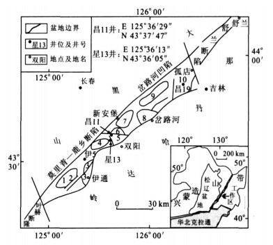
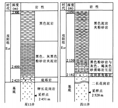
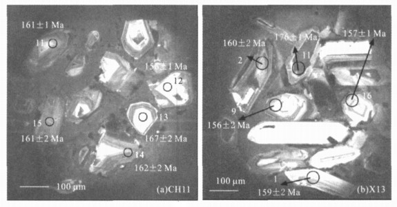
LA-ICP-MS zircon U-Pb dating was carried out for two basement granites from the Yishu graben to compare the tectonic evolutionary history between the Yishu graben and Songliao basin. The results indicate that most of zircons from the basement granites are euhedral to subhedral in shape and show the typical oscillatory zoning with magmatic origin, some of which display the core-rim structure. Their Th/U ratios range from 0.32 to 2.76, implying that they should be from crystallization of magma. The dating results indicate that a weighted mean 206pb/238U age is 162±2 Ma for the basement granite from CHll well (sample No. CHll), and that weighted mean 206Pb/238U ages are 159±3 Ma and 176± 1 Ma for rims and cores of zircons from the granite in X13 well (sample No. X13), respectively. It is suggested that the basement granites were formed in late stage of the Middle Jurassic or the beginning of the Late Jurassic, which is consistent with ones of the latest basement granites from the Songliao basin. Therefore, it is proposed that the Yishu graben displays similar evolutionary history with the Songliao basin since the Yanshannian movement, which is also proved by the occurrence of the inherited zircons with age of 176±1 Ma.
LA-ICP-MS zircon U-Pb dating was carried out for two basement granites from the Yishu graben to compare the tectonic evolutionary history between the Yishu graben and Songliao basin. The results indicate that most of zircons from the basement granites are euhedral to subhedral in shape and show the typical oscillatory zoning with magmatic origin, some of which display the core-rim structure. Their Th/U ratios range from 0.32 to 2.76, implying that they should be from crystallization of magma. The dating results indicate that a weighted mean 206pb/238U age is 162±2 Ma for the basement granite from CHll well (sample No. CHll), and that weighted mean 206Pb/238U ages are 159±3 Ma and 176± 1 Ma for rims and cores of zircons from the granite in X13 well (sample No. X13), respectively. It is suggested that the basement granites were formed in late stage of the Middle Jurassic or the beginning of the Late Jurassic, which is consistent with ones of the latest basement granites from the Songliao basin. Therefore, it is proposed that the Yishu graben displays similar evolutionary history with the Songliao basin since the Yanshannian movement, which is also proved by the occurrence of the inherited zircons with age of 176±1 Ma.

2008, 33(2): 151-164.
Abstract:
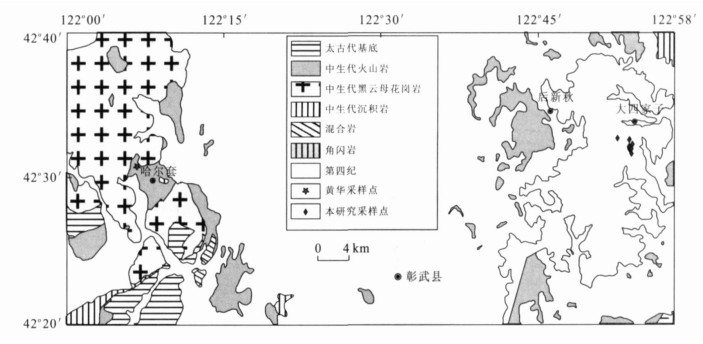
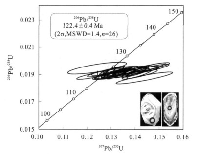
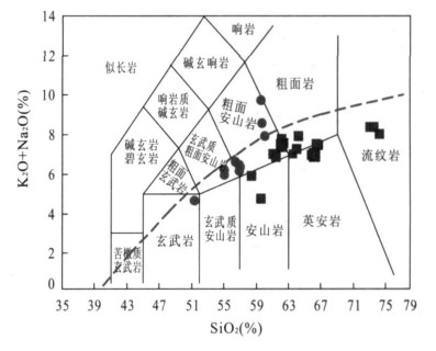
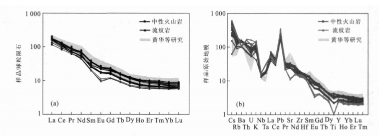
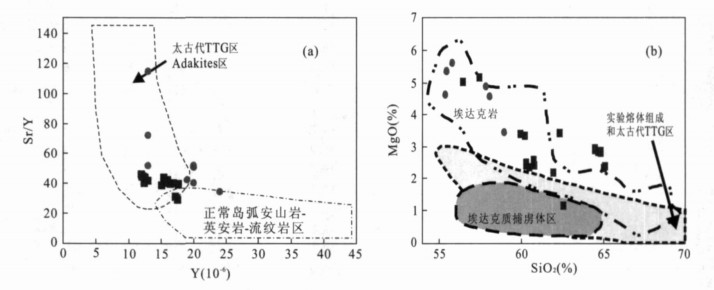
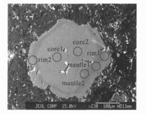
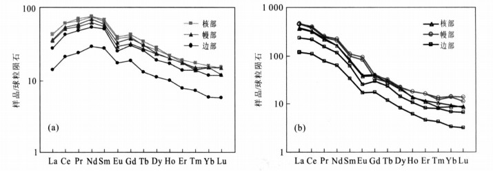
Zircon U-Pb dating by LA-ICPMS reveals that the age of Mesozoic volcanic rocks from the Zhangwu area in west Liaoning Province is 122.4± 0.4 Ma, which belongs to Early Cretaceous. Geochemical compositions of 23 typical volcanic samples are studied. The results show that most samples except three rhyolites have similar geochemical characteristics of high-Mg adakite (SiO2 =56.46%-65.14%, Al2O3 =14. 60%--17.19%, Mg# = 50--59, Sr=501- 700μg/g, Yb= 1.04- 1.54μg/g, Y= 12.0- 17.5μg/g, Eu/Eu* = 0.85 - 0.97, Sr/Y = 29 - 46, LaN/YbN = 13 - 28). They also have high initial 87Sr/86Sr (0. 706 39-0. 706 47) and low Nd (122 Ma) values (- 6.43 to - 12.26) that are inconsistent with the original ones from slab melting. Pyroxene phenocrysts are characterized by reversed compositional zonning. Rare earth element concentrations decrease from pyroxene core to rim and also show negative Eu anomalies (Eu/Eu*= 0.64-0. 76). Combined with the previous studies on volcanic rocks from the low part of Yixian Formation in Zhangwu area, we propose that our samples from Zhangwu area resulted from delamination and magma mixing. A crustally derived felsic magma resulted from partial melting of the low crust, heated by asthenosphere upwelling and subsequently mixed with a mantle-derived high-Mg adakitie melt during magma storage or ascent to surface to form the high-Mg adakites in the Zhangwu area.
Zircon U-Pb dating by LA-ICPMS reveals that the age of Mesozoic volcanic rocks from the Zhangwu area in west Liaoning Province is 122.4± 0.4 Ma, which belongs to Early Cretaceous. Geochemical compositions of 23 typical volcanic samples are studied. The results show that most samples except three rhyolites have similar geochemical characteristics of high-Mg adakite (SiO2 =56.46%-65.14%, Al2O3 =14. 60%--17.19%, Mg# = 50--59, Sr=501- 700μg/g, Yb= 1.04- 1.54μg/g, Y= 12.0- 17.5μg/g, Eu/Eu* = 0.85 - 0.97, Sr/Y = 29 - 46, LaN/YbN = 13 - 28). They also have high initial 87Sr/86Sr (0. 706 39-0. 706 47) and low Nd (122 Ma) values (- 6.43 to - 12.26) that are inconsistent with the original ones from slab melting. Pyroxene phenocrysts are characterized by reversed compositional zonning. Rare earth element concentrations decrease from pyroxene core to rim and also show negative Eu anomalies (Eu/Eu*= 0.64-0. 76). Combined with the previous studies on volcanic rocks from the low part of Yixian Formation in Zhangwu area, we propose that our samples from Zhangwu area resulted from delamination and magma mixing. A crustally derived felsic magma resulted from partial melting of the low crust, heated by asthenosphere upwelling and subsequently mixed with a mantle-derived high-Mg adakitie melt during magma storage or ascent to surface to form the high-Mg adakites in the Zhangwu area.
2008, 33(2): 165-173.
Abstract:
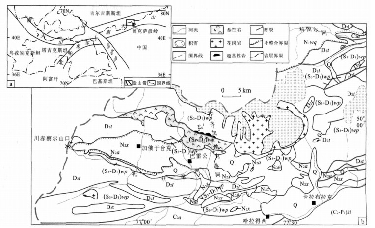
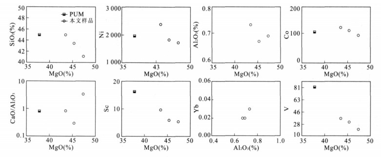
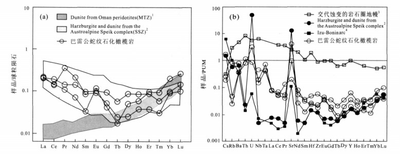
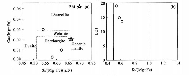
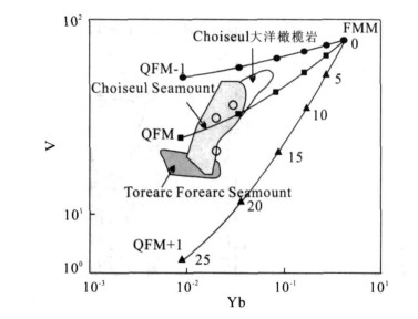
South Tianshan is a prominent intracontinental collisional orogenic belt and a key to understand the central Asia tectonic evolution.The serpentinized peridotites from Baleigong ophiolitic mélange was emplaced in the southwestern Kokshal area, which represents lithosphere remnants of the Early Paleozoic Southwestern Tianshan Ocean.The serpentinized peridotites are characterized by low Ti, Al contents and high Cr (1 604-3 863), Ni (1 719×10-6-2 375×10-6), Mg# (0.90-0.92).The right slopping PUM-normalized trace element patterns and the U-shape chondrite-normalized REE pattern reveal that these rocks cannot be residues of simple melt extraction.They can be modeled as restites after 20%-30% partial melting from already depleted mantle in a supra-subduction zone (SSZ) geotectonic setting, in which a constant flux of a slab-derived fliud component added to the mantle wedge during melting.Combined with recent studies, it is concluded that the Paleozoic Southwestern Tianshan Ocean was a mature one that had even experienced a subduction event in Early Paleozoic.The serpentinized peridotites were formed at the fore-arc of the intra-oceanic subduction zone.
South Tianshan is a prominent intracontinental collisional orogenic belt and a key to understand the central Asia tectonic evolution.The serpentinized peridotites from Baleigong ophiolitic mélange was emplaced in the southwestern Kokshal area, which represents lithosphere remnants of the Early Paleozoic Southwestern Tianshan Ocean.The serpentinized peridotites are characterized by low Ti, Al contents and high Cr (1 604-3 863), Ni (1 719×10-6-2 375×10-6), Mg# (0.90-0.92).The right slopping PUM-normalized trace element patterns and the U-shape chondrite-normalized REE pattern reveal that these rocks cannot be residues of simple melt extraction.They can be modeled as restites after 20%-30% partial melting from already depleted mantle in a supra-subduction zone (SSZ) geotectonic setting, in which a constant flux of a slab-derived fliud component added to the mantle wedge during melting.Combined with recent studies, it is concluded that the Paleozoic Southwestern Tianshan Ocean was a mature one that had even experienced a subduction event in Early Paleozoic.The serpentinized peridotites were formed at the fore-arc of the intra-oceanic subduction zone.
2008, 33(2): 174-182.
Abstract:
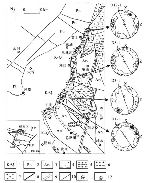
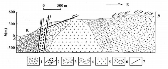
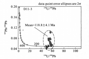
According to the particular investigations on the geometry and kinematics of the Shangma fault, three different crust-levels of extension movements have been differentiated in sequence of development from the deep to the shallow: ① ductile shearing with top to the NWW in low dip angle; ② brittle or brittle-ductile transition normal fault with top to the NWW in low dip angle; ③ brittle normal fault with top to the NWW in high dip angle. Two samples were chosen for zircon U-Pb age dating to test the constraints on the activity age of the Shangma fault. A bedding intrusive granitoid pegmatite vein which was parallel to the foliation of the ductile shear zone of the country rock which exhibits a boudinage deformation, showing syn-tetonic emplacing at the end of ductile deformation period and deformation in the brittle-ductile transition domain. The zircon U-Ph age dating of the granitoid pegmatite vein gives a result of 125.9±4.2 Ma, expressing the extension age in the brittle-ductile transition domain of the Shangma fault. Another sample, which was collected from a granite pluton cutting the foliation of the extension ductile shear zone, gives a zircon U-Ph age of 118.8±4. 1 Ma, constraining the end of the ductile shearing. Then the transformation time from ductile to brittle deformation can he constrained at 126-119 Ma.Compared with the former researches, the formation of the Luotian dome, which is located to the east of the Shangma fault can be constrained at 150-126 Ma. This study offers a new time constraint to the evolution of the Dabie orogenic belt.
According to the particular investigations on the geometry and kinematics of the Shangma fault, three different crust-levels of extension movements have been differentiated in sequence of development from the deep to the shallow: ① ductile shearing with top to the NWW in low dip angle; ② brittle or brittle-ductile transition normal fault with top to the NWW in low dip angle; ③ brittle normal fault with top to the NWW in high dip angle. Two samples were chosen for zircon U-Pb age dating to test the constraints on the activity age of the Shangma fault. A bedding intrusive granitoid pegmatite vein which was parallel to the foliation of the ductile shear zone of the country rock which exhibits a boudinage deformation, showing syn-tetonic emplacing at the end of ductile deformation period and deformation in the brittle-ductile transition domain. The zircon U-Ph age dating of the granitoid pegmatite vein gives a result of 125.9±4.2 Ma, expressing the extension age in the brittle-ductile transition domain of the Shangma fault. Another sample, which was collected from a granite pluton cutting the foliation of the extension ductile shear zone, gives a zircon U-Ph age of 118.8±4. 1 Ma, constraining the end of the ductile shearing. Then the transformation time from ductile to brittle deformation can he constrained at 126-119 Ma.Compared with the former researches, the formation of the Luotian dome, which is located to the east of the Shangma fault can be constrained at 150-126 Ma. This study offers a new time constraint to the evolution of the Dabie orogenic belt.


2008, 33(2): 183-189.
Abstract:
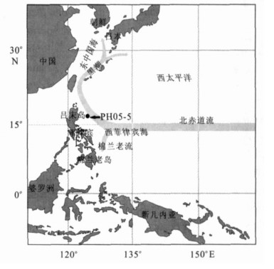
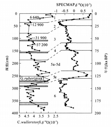
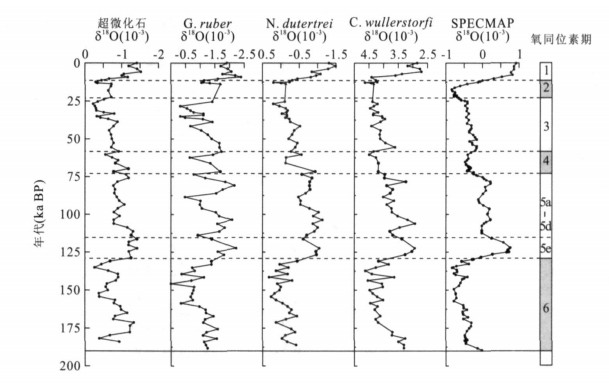
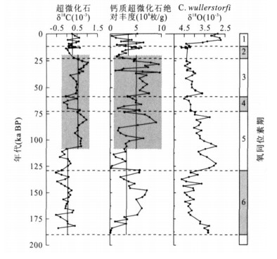
The piston core Ph05-5 recovered from the West Philippine Sea (16.049 3°N, 124.344 8°E, water depth 3 382 m) was used to study the δ18O and δ13C variations of calcareous nannofossils.The δ18O values of calcareous nannofossils were obviously lower in Holocene and the last interglaciation than those in the last and the penultimate glaciation.During the last 190 ka the nannofossil δ18O values were positively correlated with those of planktonic and benthic foraminifera from the same core.But the average δ18O value of nannofossils was 0.431×10⁻³, higher than that of planktonic foraminifera Globigerinoides rubber, and was 0.410×10⁻³, lower than that of planktonic foraminifera Neogloboquad rina dutertrei.All the above three average δ18O values were much lower than those of benthic foraminifera Cibicides wullerstorfi.The change of nannofossil δ13C values showed similar trends with the absolute abundance of calcareous nannofossils in core Ph05-5, which also indicates the primary productivity variations in the West Philippine Sea.The primary productivity stayed at a stable but relatively low level at MIS 6 and MIS 5e.There was an abrupt rise at the beginning of MIS 5d for the primary productivity which retained high value until 25 ka BP.The primary productivity showed a slight decline during MIS 2 and MIS 1, but still higher than that of MIS 6 and MIS 5e.
The piston core Ph05-5 recovered from the West Philippine Sea (16.049 3°N, 124.344 8°E, water depth 3 382 m) was used to study the δ18O and δ13C variations of calcareous nannofossils.The δ18O values of calcareous nannofossils were obviously lower in Holocene and the last interglaciation than those in the last and the penultimate glaciation.During the last 190 ka the nannofossil δ18O values were positively correlated with those of planktonic and benthic foraminifera from the same core.But the average δ18O value of nannofossils was 0.431×10⁻³, higher than that of planktonic foraminifera Globigerinoides rubber, and was 0.410×10⁻³, lower than that of planktonic foraminifera Neogloboquad rina dutertrei.All the above three average δ18O values were much lower than those of benthic foraminifera Cibicides wullerstorfi.The change of nannofossil δ13C values showed similar trends with the absolute abundance of calcareous nannofossils in core Ph05-5, which also indicates the primary productivity variations in the West Philippine Sea.The primary productivity stayed at a stable but relatively low level at MIS 6 and MIS 5e.There was an abrupt rise at the beginning of MIS 5d for the primary productivity which retained high value until 25 ka BP.The primary productivity showed a slight decline during MIS 2 and MIS 1, but still higher than that of MIS 6 and MIS 5e.
2008, 33(2): 190-196.
Abstract:
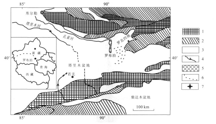
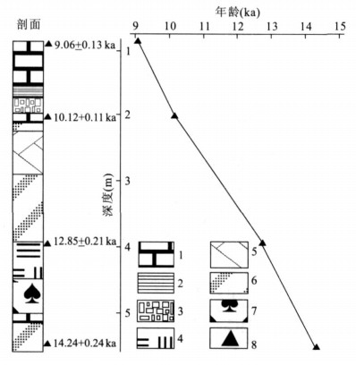
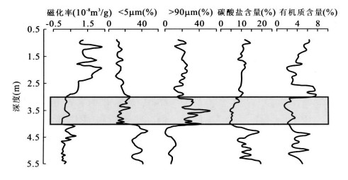
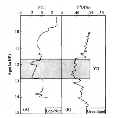
The environmental proxies of the susceptibility, particle size, and the contents of carbonate and organic carbon in the lacustrine sediments of the CK-2 core from Lop-Nur Lake, Xinjiang, Northwest China are determined in this study.The core section corresponds to the 0.94-5.50 m and 9-14 kaBP.The reconstructed records in Xinjiang, NW China fully demonstrate that the Younger Dryas event occurred within 12.8-11.6 ka BP synchronously with that record in Greenland ice core, and its climate appeared to be cool and humid.These results suggest the rapid response of westerly climate system in the NW China to the climate variability in northern high latitudes in short time.A mechanism involving immigration of westerly winds and the intensity change of the westerly is tentatively proposed to account for this synchronicity.
The environmental proxies of the susceptibility, particle size, and the contents of carbonate and organic carbon in the lacustrine sediments of the CK-2 core from Lop-Nur Lake, Xinjiang, Northwest China are determined in this study.The core section corresponds to the 0.94-5.50 m and 9-14 kaBP.The reconstructed records in Xinjiang, NW China fully demonstrate that the Younger Dryas event occurred within 12.8-11.6 ka BP synchronously with that record in Greenland ice core, and its climate appeared to be cool and humid.These results suggest the rapid response of westerly climate system in the NW China to the climate variability in northern high latitudes in short time.A mechanism involving immigration of westerly winds and the intensity change of the westerly is tentatively proposed to account for this synchronicity.
2008, 33(2): 197-204.
Abstract:
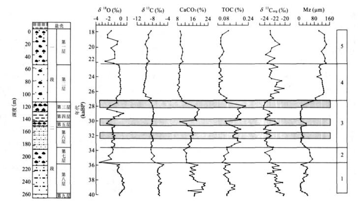
Based on the analysis of TOC, CaCO3, δ13 Corg, δ18 O, δ13 C of shell bar sediments in the Qaidam basin and the comparison with grain size, the environmental change of the studied section are divided into five stages.From 39.7 to 35.8 ka BP is the period of high paleolake level development.From 35.8 to 33.6 ka BP and 33.6 to 27.2 ka BP, TOC and CaCO3 contents, δ18 O value are high, while δ13 Corg value and median size content are low, which reflects a warm-humid climate and high lake level.During 27.2-22.3 ka BP and 22.3-17.5 ka BP, both the temperature and the lake level are lower than that of previous stages (but the climate was still warmer and more humid than that of today).The lake level decreased between 32.4 and 32.2 ka BP, 30.4 and 29.8 ka BP, 28.4 and 27.2 ka BP.Generally speaking, the climate was warm and humid in Qaidam basin and the high lake level sustained between 39.7 and 17.5 ka BP.The lake retreated abruptly at 17.5 ka BP, with a very strong increase of evaporation which resulted in the salt formation and the decrease of the high lake level.
Based on the analysis of TOC, CaCO3, δ13 Corg, δ18 O, δ13 C of shell bar sediments in the Qaidam basin and the comparison with grain size, the environmental change of the studied section are divided into five stages.From 39.7 to 35.8 ka BP is the period of high paleolake level development.From 35.8 to 33.6 ka BP and 33.6 to 27.2 ka BP, TOC and CaCO3 contents, δ18 O value are high, while δ13 Corg value and median size content are low, which reflects a warm-humid climate and high lake level.During 27.2-22.3 ka BP and 22.3-17.5 ka BP, both the temperature and the lake level are lower than that of previous stages (but the climate was still warmer and more humid than that of today).The lake level decreased between 32.4 and 32.2 ka BP, 30.4 and 29.8 ka BP, 28.4 and 27.2 ka BP.Generally speaking, the climate was warm and humid in Qaidam basin and the high lake level sustained between 39.7 and 17.5 ka BP.The lake retreated abruptly at 17.5 ka BP, with a very strong increase of evaporation which resulted in the salt formation and the decrease of the high lake level.
2008, 33(2): 205-209.
Abstract:
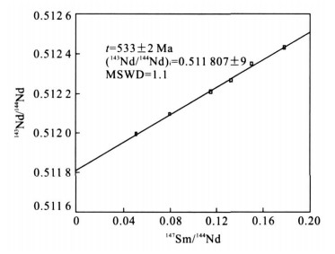
In order to discuss the age and the provenance of the Zhijin REE-bearing phosphorites in Guizhou, six small shell fossils and cellophane sampled from the phosphorites are dated by Sm-Nd isotopic dilution method.The results of mass spectrographic analysis show that the value of 147Sm/144Nd and 143Nd/144Nd formed an isochronal line.The test shows that the Sm-Nd isochronal dating of Zhijin REE-bearing phosphorites is 533±22 Ma (MSWD=1.1).The εNd (t) of the samples are about-2.44 to-2.77, and the Nd two-stage model ages (T2DM) are 1 313-1 338 Ma.This result suggests that the samples have the same genesis and the approximative age, and the age represents the true mineralogenetic epoch.Combined with the REE geochemistry the juvenile mantle is responsible to the provenance of the Zhijin REE-bearing phosphorites.
In order to discuss the age and the provenance of the Zhijin REE-bearing phosphorites in Guizhou, six small shell fossils and cellophane sampled from the phosphorites are dated by Sm-Nd isotopic dilution method.The results of mass spectrographic analysis show that the value of 147Sm/144Nd and 143Nd/144Nd formed an isochronal line.The test shows that the Sm-Nd isochronal dating of Zhijin REE-bearing phosphorites is 533±22 Ma (MSWD=1.1).The εNd (t) of the samples are about-2.44 to-2.77, and the Nd two-stage model ages (T2DM) are 1 313-1 338 Ma.This result suggests that the samples have the same genesis and the approximative age, and the age represents the true mineralogenetic epoch.Combined with the REE geochemistry the juvenile mantle is responsible to the provenance of the Zhijin REE-bearing phosphorites.
2008, 33(2): 210-218.
Abstract:
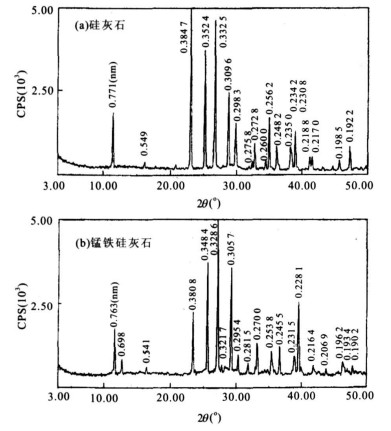
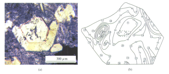
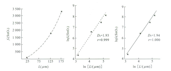
Jinchuantang is an important mining area in operation in the super large W-Sn-Mo-Bi deposit of Shizhuyuan, Hunan Province.The mineral characteristics of the massive skarn of the area are: the garnet is mainly of anorthite; the pyroxene exists as continuous series of dipside-salite-ferrosolite-hedenbergite; the feldspar is mainly of anorthite; the wollastonite is found as a type of a rare mineral- (Mn, Fe) -wollastonite; the sphene is widely-spread as a skarn mineral, and its content of aluminum oxide is relatively high (maximum content being 8.32%wt), and the Sn content of some sphene minerals is also relatively high; Sn is also widely spread in the mineral epidote, and the content of SnO2 is 0.2%-2%.According to the distribution and the content of SnO2 in the mineral epidote, it is found that, the content has the power function with its location, and the calculated fractional-dimension from the distribution of tin oxide is 1.93.From the mineral micro-scale, the transportation and distribution of ore element tin possess the fractional dimension time-location structure, and it is confirmed that the self-constructing critical situation is the basic dynamical characteristic of the super large multi-metal deposit of Shizhuyuan.
Jinchuantang is an important mining area in operation in the super large W-Sn-Mo-Bi deposit of Shizhuyuan, Hunan Province.The mineral characteristics of the massive skarn of the area are: the garnet is mainly of anorthite; the pyroxene exists as continuous series of dipside-salite-ferrosolite-hedenbergite; the feldspar is mainly of anorthite; the wollastonite is found as a type of a rare mineral- (Mn, Fe) -wollastonite; the sphene is widely-spread as a skarn mineral, and its content of aluminum oxide is relatively high (maximum content being 8.32%wt), and the Sn content of some sphene minerals is also relatively high; Sn is also widely spread in the mineral epidote, and the content of SnO2 is 0.2%-2%.According to the distribution and the content of SnO2 in the mineral epidote, it is found that, the content has the power function with its location, and the calculated fractional-dimension from the distribution of tin oxide is 1.93.From the mineral micro-scale, the transportation and distribution of ore element tin possess the fractional dimension time-location structure, and it is confirmed that the self-constructing critical situation is the basic dynamical characteristic of the super large multi-metal deposit of Shizhuyuan.
2008, 33(2): 219-226.
Abstract:
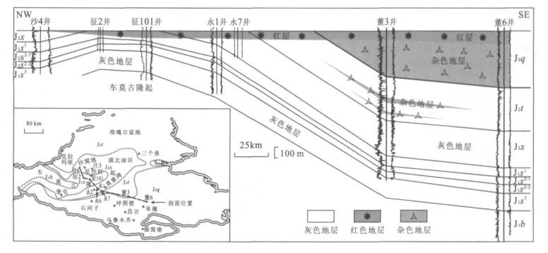
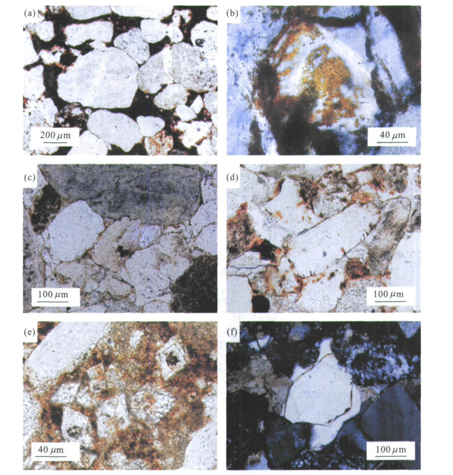
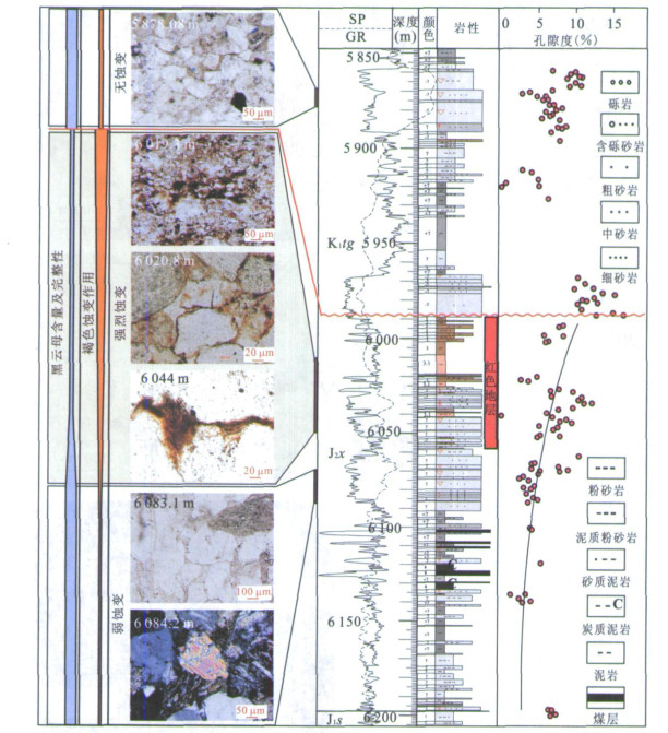
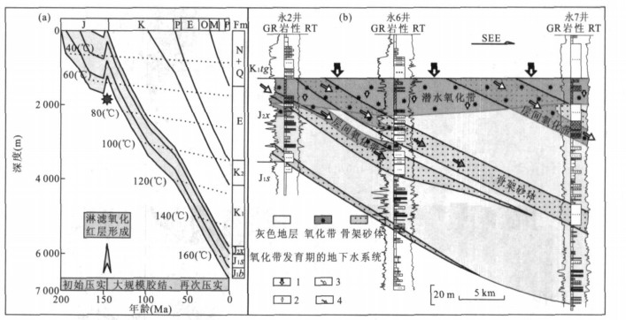
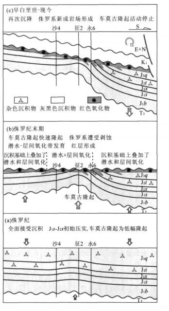
Exploration of oil and gas in the central part of Junggar basin has shed light on the evolution of the Chepaizi-Mosuowan paleo-uplift, and the study of red beds beneath the unconformity between Jurassic and Cretaceous indicates that the processes of diagenesis provides information about the evolutionary history of the uplift.It is found that the red beds did not form by syn-sedimentary rubifaction but by diagenetic hematitization which can be explained by models of phreatic oxidation and interlayer oxidation occurring during the development of sandstone hosted uranium deposits.They underwent processes of initial compaction, eluviation (hematitization or brown alteration forming red beds), cementation by dolomite, calcite and/or silica, secondary compaction and deep diagenetic cementation by chlorite.The order of diagenetic events documents the evolutionary history of the Chepaizi-Mosuowan paleo-uplift.Initial compaction indicates that there was continuous deposition in the Jurassic, because the burial was deep and the uplift velocity of the uplift was less than the subsidence velocity of the Junggar Basin.Later eluviation indicates that uplift rates exceeded those of subsidence and Jurassic beds were exposed at the surface where they underwent general phreatic oxidation and interlayer oxidation.Subsequent secondary compaction accompanied by massive cementation indicates that the Jurassic red beds were once again deeply buried as the result of Cretaceous and Cenozoic basin filling.This sequence of diagenetic events thus documents the history of tectonism in the central part of the Junggar basin structure.
Exploration of oil and gas in the central part of Junggar basin has shed light on the evolution of the Chepaizi-Mosuowan paleo-uplift, and the study of red beds beneath the unconformity between Jurassic and Cretaceous indicates that the processes of diagenesis provides information about the evolutionary history of the uplift.It is found that the red beds did not form by syn-sedimentary rubifaction but by diagenetic hematitization which can be explained by models of phreatic oxidation and interlayer oxidation occurring during the development of sandstone hosted uranium deposits.They underwent processes of initial compaction, eluviation (hematitization or brown alteration forming red beds), cementation by dolomite, calcite and/or silica, secondary compaction and deep diagenetic cementation by chlorite.The order of diagenetic events documents the evolutionary history of the Chepaizi-Mosuowan paleo-uplift.Initial compaction indicates that there was continuous deposition in the Jurassic, because the burial was deep and the uplift velocity of the uplift was less than the subsidence velocity of the Junggar Basin.Later eluviation indicates that uplift rates exceeded those of subsidence and Jurassic beds were exposed at the surface where they underwent general phreatic oxidation and interlayer oxidation.Subsequent secondary compaction accompanied by massive cementation indicates that the Jurassic red beds were once again deeply buried as the result of Cretaceous and Cenozoic basin filling.This sequence of diagenetic events thus documents the history of tectonism in the central part of the Junggar basin structure.

2008, 33(2): 227-234.
Abstract:
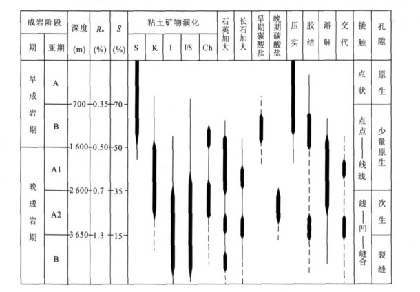
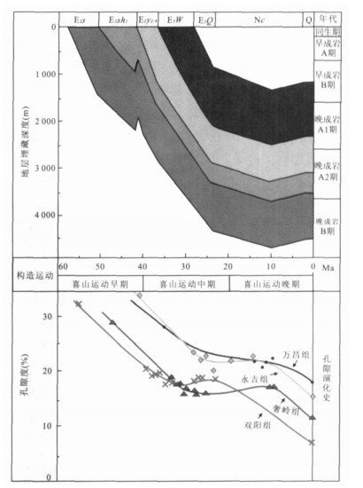
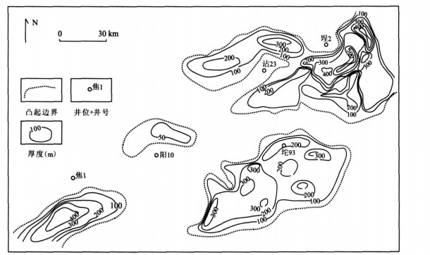
The characteristics and diagenetic types of Chaluhe reservoir were studied in terms of the data of drill cores, slices, scanning electron microscopy, X-ray diffraction.According to the criterion of division, the diagenetic phases are divided into early diagenetic A stage, B stage, and late diagenetic A stage and B stage, and the late diagenetic A stage is divided into A1 stage and A2 stage.By using the software of BasinMode, the burial history and thermal history of the primary structure were analyzed, and combined with the result of porosity evolution history, the reservoir diagenetic evolution was studied.The result is: before 30 Ma, the primary diagenesis was compaction and cementation.The porosity in the formation of Shanyang and Sheling reduced to 15% from 32% approximately, and that of Yongji and Wanchang reduced to 20% from 32% approximately; During the period of 30 Ma and 10 Ma, all the formations had been buried to the deepest depth and the feldspars in the sandstone formations of Shuangyang and Sheling began to dissolve, which caused the porosity to increase to 18%, providing space for the storage of oil and gas; but the porosity unchanged in the formation of Yongji and Wanchang during this period.Three diagenetic modes (alluvial fan, fan-delta, deep and half-deep lacustrine facies) are built in Chaluhe fault depression based on the study of burial history, thermal evolution history of organic, diagenetic evolution history, the rock type and sedimentary facies.
The characteristics and diagenetic types of Chaluhe reservoir were studied in terms of the data of drill cores, slices, scanning electron microscopy, X-ray diffraction.According to the criterion of division, the diagenetic phases are divided into early diagenetic A stage, B stage, and late diagenetic A stage and B stage, and the late diagenetic A stage is divided into A1 stage and A2 stage.By using the software of BasinMode, the burial history and thermal history of the primary structure were analyzed, and combined with the result of porosity evolution history, the reservoir diagenetic evolution was studied.The result is: before 30 Ma, the primary diagenesis was compaction and cementation.The porosity in the formation of Shanyang and Sheling reduced to 15% from 32% approximately, and that of Yongji and Wanchang reduced to 20% from 32% approximately; During the period of 30 Ma and 10 Ma, all the formations had been buried to the deepest depth and the feldspars in the sandstone formations of Shuangyang and Sheling began to dissolve, which caused the porosity to increase to 18%, providing space for the storage of oil and gas; but the porosity unchanged in the formation of Yongji and Wanchang during this period.Three diagenetic modes (alluvial fan, fan-delta, deep and half-deep lacustrine facies) are built in Chaluhe fault depression based on the study of burial history, thermal evolution history of organic, diagenetic evolution history, the rock type and sedimentary facies.

2008, 33(2): 235-242.
Abstract:
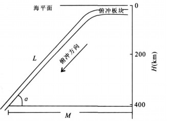
In order to research the influence of mantle plume tectonics and plate subduction on the Jiyang depression, the geological characteristics of Jiyang depression and the results of the seismic source of earthquake and plate subduction are analyzed, based on the preview studies of the mantle plume.The result shows that the sedimentary stratum, the activities of magma, geological extension, the grads of terrestrial, and the reservoir sand are distributed regularly from south to north in Jiyang depression.The process of plate subducting into mantle formed the downwelling of mantle convection, the depth of 660 km (or 670 km) of the mantle is the depth of the upwelling which was adjusted by the matter of mantle after plate subducting into mantle.The downthrust angle of the subduction of western Pacific plate decreases from south to north, and the time of subducted plate reaching the discontinutity surface of earthquake increases from south to north, which resulted in the mantle plume transfer from south to north and regular distribution of the geology, geophysical characteristics from south to north in Jiyang depression.
In order to research the influence of mantle plume tectonics and plate subduction on the Jiyang depression, the geological characteristics of Jiyang depression and the results of the seismic source of earthquake and plate subduction are analyzed, based on the preview studies of the mantle plume.The result shows that the sedimentary stratum, the activities of magma, geological extension, the grads of terrestrial, and the reservoir sand are distributed regularly from south to north in Jiyang depression.The process of plate subducting into mantle formed the downwelling of mantle convection, the depth of 660 km (or 670 km) of the mantle is the depth of the upwelling which was adjusted by the matter of mantle after plate subducting into mantle.The downthrust angle of the subduction of western Pacific plate decreases from south to north, and the time of subducted plate reaching the discontinutity surface of earthquake increases from south to north, which resulted in the mantle plume transfer from south to north and regular distribution of the geology, geophysical characteristics from south to north in Jiyang depression.
2008, 33(2): 243-250.
Abstract:
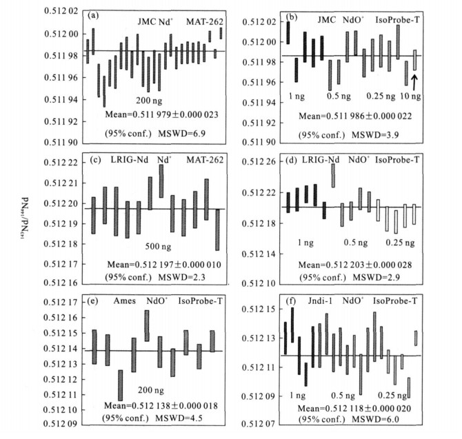
Precise measurement of Nd isotopic ratio of micro-samples, being one of the most difficult tasks in measurements of isotopic ratios, plays an important role in research fields of earth and environmental sciences.This study reports the results of precise measurements of Nd isotopic ratios on the solutions of international standard material using less 1 ng samples.Applying the Nd+ and NdO+ measurement methods, solutions of the standard material (Ames, JMC, and Jndi-1) and the laboratory-own reference material (LRIG-Nd), which contain ≥200 ng to 0.25 ng Nd samples, were measured by a new thermal ionization mass spectrometer (IsoProbe-T).Data acquisition during the isotopic measurement was done by using a static mode with a multiple-receiver configuration.Internal and external precisions obtained for all the measurements of 143Nd/144Nd ratio were better than 0.003%.Compared with the Nd+ method, Nd isotopic measurement using the NdO+ method distinguishably displays an advantage in high sensibility of measurement, being about 100 times higher than that by using the Nd+ method.
Precise measurement of Nd isotopic ratio of micro-samples, being one of the most difficult tasks in measurements of isotopic ratios, plays an important role in research fields of earth and environmental sciences.This study reports the results of precise measurements of Nd isotopic ratios on the solutions of international standard material using less 1 ng samples.Applying the Nd+ and NdO+ measurement methods, solutions of the standard material (Ames, JMC, and Jndi-1) and the laboratory-own reference material (LRIG-Nd), which contain ≥200 ng to 0.25 ng Nd samples, were measured by a new thermal ionization mass spectrometer (IsoProbe-T).Data acquisition during the isotopic measurement was done by using a static mode with a multiple-receiver configuration.Internal and external precisions obtained for all the measurements of 143Nd/144Nd ratio were better than 0.003%.Compared with the Nd+ method, Nd isotopic measurement using the NdO+ method distinguishably displays an advantage in high sensibility of measurement, being about 100 times higher than that by using the Nd+ method.
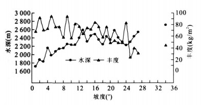
2008, 33(2): 251-258.
Abstract:
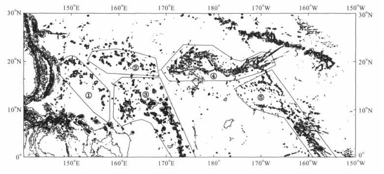
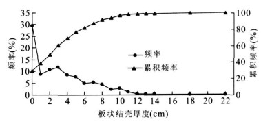
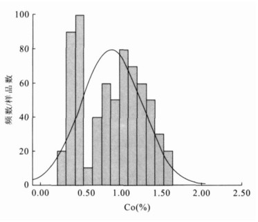
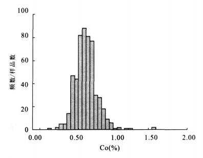
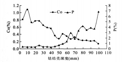
Marine Co-riched crusts are important as potential mineral resources for Co, Ni, Pt, Mn, and other metals, as well as for the paleoenvironment signals stored in their stratigraphic layers.The higher Co, Ni and Pt content of crusts relative to abyssal polymetallic nodules and hydrothermal deposits have made seamount crusts a potential target for commercial exploitation and has thus led to a surge of interest in their genesis and geochemistry.Twenty-six seamounts and guyots in the Western Pacific (Maggellan Seamounts, Marcus-Wake Mountains, Marshall Islands, Mid-Pacific Mountains, Line Islands) were sampled in detail, environmentally surveyed, and photographed by bottom cameras in order to better understand the distribution, origin, and evolution of marine Co-enriched crusts by Second Institute of Oceanography of SOA and Guangzhou Marine Geological Survey of MLR in the last decade.The major purpose of exploiting Co-riched crusts is to delineate and mine the deposits.Unfortunately, the parameter and index for delineating and evaluating the crust resources are not available so far.Based on the various data collected from the twenty-six seamounts and guyots, together with marine environment information of the Pacific, we have analyzed the changes of crust thickness, abundance, grade, coverage, resource amount, seamount slope and water depth by the quantitative method.We determined the mine area, studied the distribution characteristics of crust resources, delineated and evaluated the crust resources of thirteen typical seamounts and guyots.Accordingly proposed eight important parameters and indexes for delineating and evaluating Co-enriched crust deposits: (1) crust thickness ≥3 cm or ≥4 cm, depending on the different seamount locations; (2) water depth ≤2 500 m or ≤3 000 m; (3) Co content ≥0.50% or ≥0.60%; (4) abundance ≥ 60 kg/m2 or ≥70 kg/m2; (5) seamount slope ≤15°; (6) crust coverage ≥30%; (7) application area 17 000-20 000 km2; (8) reservation area 5 000-6 000 km2.The parameters and indexes we present here will promote the deposit delineation, resource estimation and evaluation, and will also provide the quantitative parameter index for our country's active participation into the establishment of regulations on exploiting Co-enriched crust resources by the International Sea-bed Authority of United Nations.
Marine Co-riched crusts are important as potential mineral resources for Co, Ni, Pt, Mn, and other metals, as well as for the paleoenvironment signals stored in their stratigraphic layers.The higher Co, Ni and Pt content of crusts relative to abyssal polymetallic nodules and hydrothermal deposits have made seamount crusts a potential target for commercial exploitation and has thus led to a surge of interest in their genesis and geochemistry.Twenty-six seamounts and guyots in the Western Pacific (Maggellan Seamounts, Marcus-Wake Mountains, Marshall Islands, Mid-Pacific Mountains, Line Islands) were sampled in detail, environmentally surveyed, and photographed by bottom cameras in order to better understand the distribution, origin, and evolution of marine Co-enriched crusts by Second Institute of Oceanography of SOA and Guangzhou Marine Geological Survey of MLR in the last decade.The major purpose of exploiting Co-riched crusts is to delineate and mine the deposits.Unfortunately, the parameter and index for delineating and evaluating the crust resources are not available so far.Based on the various data collected from the twenty-six seamounts and guyots, together with marine environment information of the Pacific, we have analyzed the changes of crust thickness, abundance, grade, coverage, resource amount, seamount slope and water depth by the quantitative method.We determined the mine area, studied the distribution characteristics of crust resources, delineated and evaluated the crust resources of thirteen typical seamounts and guyots.Accordingly proposed eight important parameters and indexes for delineating and evaluating Co-enriched crust deposits: (1) crust thickness ≥3 cm or ≥4 cm, depending on the different seamount locations; (2) water depth ≤2 500 m or ≤3 000 m; (3) Co content ≥0.50% or ≥0.60%; (4) abundance ≥ 60 kg/m2 or ≥70 kg/m2; (5) seamount slope ≤15°; (6) crust coverage ≥30%; (7) application area 17 000-20 000 km2; (8) reservation area 5 000-6 000 km2.The parameters and indexes we present here will promote the deposit delineation, resource estimation and evaluation, and will also provide the quantitative parameter index for our country's active participation into the establishment of regulations on exploiting Co-enriched crust resources by the International Sea-bed Authority of United Nations.
2008, 33(2): 259-265.
Abstract:
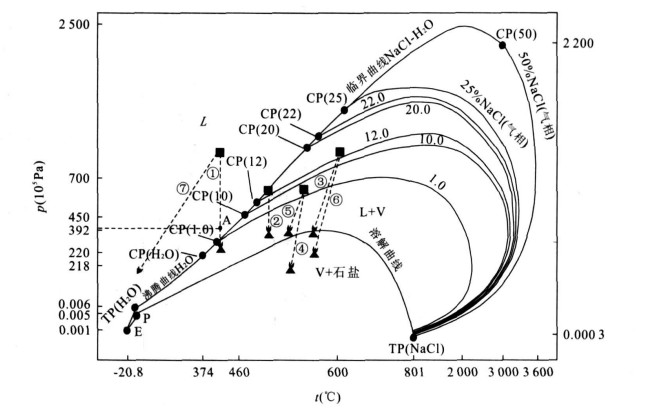
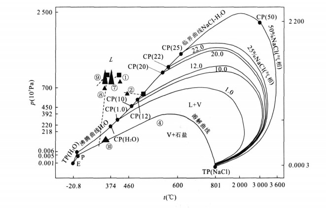
Synthetic fluid inclusions were studied in order to discuss formational mechanisms of homogeneous fluid and boiling fluid in detail.The results of experiments of fluid inclusion synthesizing show frequent occurrences of homogeneous fluid and boiling fluid, was closely in relation to the position of its p-t locus in TP (H2O)-CP(H2O)-CP(NaCl-H2O) curve of p-t phase diagram of NaCl-H2O system determined whether the fluid was homogeneous.If it was at the upper zone of TP (H2O)-CP(H2O)-CP(NaCl-H2O) curve, then the fluid was homogeneous, otherwise, the fluid was boiling.But the fluid trapped on the solution curve of NaCl in water was an exception, for example No.10 experiment.This was very beneficial for us to study on the formation mechanism of fluid and mineralization in the ore deposit.
Synthetic fluid inclusions were studied in order to discuss formational mechanisms of homogeneous fluid and boiling fluid in detail.The results of experiments of fluid inclusion synthesizing show frequent occurrences of homogeneous fluid and boiling fluid, was closely in relation to the position of its p-t locus in TP (H2O)-CP(H2O)-CP(NaCl-H2O) curve of p-t phase diagram of NaCl-H2O system determined whether the fluid was homogeneous.If it was at the upper zone of TP (H2O)-CP(H2O)-CP(NaCl-H2O) curve, then the fluid was homogeneous, otherwise, the fluid was boiling.But the fluid trapped on the solution curve of NaCl in water was an exception, for example No.10 experiment.This was very beneficial for us to study on the formation mechanism of fluid and mineralization in the ore deposit.
2008, 33(2): 266-272.
Abstract:
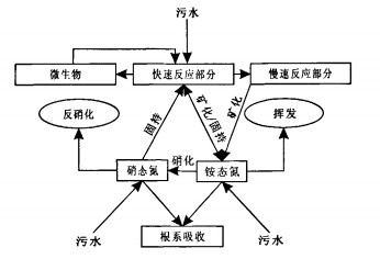
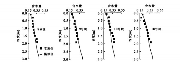
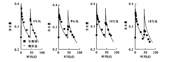
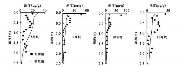
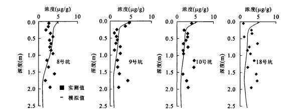
Nitrogen-2D is a physically-based model developed on the basis of SWMS-2D to predict the fate of nitrogen and phosphorus following irrigation with effluent.To test the model, a sewage effluent irrigation experiment was conducted.In this paper, the nitrogen-2D model is extended and tested with data from four effluent-irrigated winter wheat plantations.The results show that, on the whole, measured and simulated values are in reasonably good agreement, especially soil water content and soil ammonia content, which indicates that it can offer reliable prediction of the fate of water and nitrogen in spite of the relative simplicity of the model.The model is then used to estimate the soil nitrogen and phosphorus behavior in winter wheat field under the same situation with different concentrations of nitrogen and phosphorus in the sewage effluent.The results show that under the simulated conditions, no nitrogen or phosphorus leaching happened at 1.5 m depth in the period, and because of the strong adsorbability of the soil, 49% of the ammonia following irrigation with effluent was turned into nitrate by nitration instead of uptake.Denitrification of nitrate is the major channel resulting in loss of soil nitrogen fertilizer with a volume of about 12.6% of the input nitrogen.Nitrate is much more available for crop than ammonia and the current fertilization utilization rate is 23.3%.
Nitrogen-2D is a physically-based model developed on the basis of SWMS-2D to predict the fate of nitrogen and phosphorus following irrigation with effluent.To test the model, a sewage effluent irrigation experiment was conducted.In this paper, the nitrogen-2D model is extended and tested with data from four effluent-irrigated winter wheat plantations.The results show that, on the whole, measured and simulated values are in reasonably good agreement, especially soil water content and soil ammonia content, which indicates that it can offer reliable prediction of the fate of water and nitrogen in spite of the relative simplicity of the model.The model is then used to estimate the soil nitrogen and phosphorus behavior in winter wheat field under the same situation with different concentrations of nitrogen and phosphorus in the sewage effluent.The results show that under the simulated conditions, no nitrogen or phosphorus leaching happened at 1.5 m depth in the period, and because of the strong adsorbability of the soil, 49% of the ammonia following irrigation with effluent was turned into nitrate by nitration instead of uptake.Denitrification of nitrate is the major channel resulting in loss of soil nitrogen fertilizer with a volume of about 12.6% of the input nitrogen.Nitrate is much more available for crop than ammonia and the current fertilization utilization rate is 23.3%.
2008, 33(2): 273-278.
Abstract:
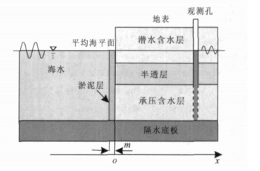
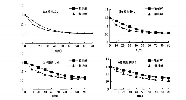
With the social and economic development in coastal areas, a variety of hydrogeological problems arise.In order to solve these problems, it is necessary to study hydraulic relation between ground water and seawater.This paper explores the tide-induced ground water head fluctuation in a coastal multi-layered aquifer system with a suboutcrop covered by a silt layer.The system consists of an unconfined aquifer, a leaky confined aquifer and a semi-permeable layer in the middle.The mathematical model for describing the system is built and the analytical solution to the model is derived.The analytical solution contains two dimensionless parameters: the leakances of the semi-permeable layer and the silt-layer, respectively.The silt layer reduces the amplitude of the hydraulic head fluctuation by a constant factor, and increases the phase by a positive shift (time-lag), both of which depend on the leakances of the silt layer and the semi-permeable layer.The time lag does not exceed 1.5 h and 3.0 h for semidiurnal and diurnal sea tides, respectively.When the leakance of the semi-permeable layer or the silt layer assumes certain special values, the solutions are in accordance with the ones derived by several previous researchers.The amplitude of the hydraulic head fluctuation in the confined aquifer increases with the leakance of the silt-layer and decreases with the leakance of the semi-permeable layer; while the phase shift of fluctuation decreases with both of them.The solution analysis indicates that both the silt layer and the leakance of the semi-permeable layer influence significantly the hydraulic head fluctuation in the confined aquifer.
With the social and economic development in coastal areas, a variety of hydrogeological problems arise.In order to solve these problems, it is necessary to study hydraulic relation between ground water and seawater.This paper explores the tide-induced ground water head fluctuation in a coastal multi-layered aquifer system with a suboutcrop covered by a silt layer.The system consists of an unconfined aquifer, a leaky confined aquifer and a semi-permeable layer in the middle.The mathematical model for describing the system is built and the analytical solution to the model is derived.The analytical solution contains two dimensionless parameters: the leakances of the semi-permeable layer and the silt-layer, respectively.The silt layer reduces the amplitude of the hydraulic head fluctuation by a constant factor, and increases the phase by a positive shift (time-lag), both of which depend on the leakances of the silt layer and the semi-permeable layer.The time lag does not exceed 1.5 h and 3.0 h for semidiurnal and diurnal sea tides, respectively.When the leakance of the semi-permeable layer or the silt layer assumes certain special values, the solutions are in accordance with the ones derived by several previous researchers.The amplitude of the hydraulic head fluctuation in the confined aquifer increases with the leakance of the silt-layer and decreases with the leakance of the semi-permeable layer; while the phase shift of fluctuation decreases with both of them.The solution analysis indicates that both the silt layer and the leakance of the semi-permeable layer influence significantly the hydraulic head fluctuation in the confined aquifer.
2008, 33(2): 279-284.
Abstract:
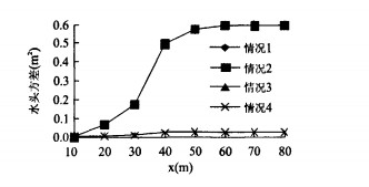
Dynamically stochastic simulation of flow in a phreatic aquifer is a complicated and challenging issue. A perturbation finite element model for transient two-dimensional flow in a phreatic aquifer is developed and presented in this paper. In the model, stochastic variables include hydraulic conductivity and specific yield in governing equation, as well as source/sink and boundary conditions, 9 equations are derived in order to solve expectation and variance of two-dimensional unsteady flow and specific numeric treatment is adopted for different equation discreteness. In the end, simulated results are analyzed by a hypothetical example, and it shows that the influence of variation of boundary condition variance and hydraulic conductivity variance is little and that of variation of specific yield variance is significant. This model can be applied to general stochastic simulation of unsteady flow in a phreatic aquifer due to the fact that it takes into account all relevant factors. The study presents the influence on dynamic simulation of flow in phreatic water by stochastic variables of boundary condition, hydraulic conductivity and specific yield and it offers an alternative theory of stochastic simulation of ground water flow.
Dynamically stochastic simulation of flow in a phreatic aquifer is a complicated and challenging issue. A perturbation finite element model for transient two-dimensional flow in a phreatic aquifer is developed and presented in this paper. In the model, stochastic variables include hydraulic conductivity and specific yield in governing equation, as well as source/sink and boundary conditions, 9 equations are derived in order to solve expectation and variance of two-dimensional unsteady flow and specific numeric treatment is adopted for different equation discreteness. In the end, simulated results are analyzed by a hypothetical example, and it shows that the influence of variation of boundary condition variance and hydraulic conductivity variance is little and that of variation of specific yield variance is significant. This model can be applied to general stochastic simulation of unsteady flow in a phreatic aquifer due to the fact that it takes into account all relevant factors. The study presents the influence on dynamic simulation of flow in phreatic water by stochastic variables of boundary condition, hydraulic conductivity and specific yield and it offers an alternative theory of stochastic simulation of ground water flow.
2008, 33(2): 285-288.
Abstract:
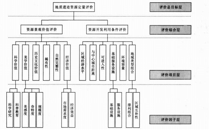
Although there is much work done on the geoparks at home and abroad, there are few researches done on the assessment index system of geological relic resources.Based on detailed studies on geological relic resources assessment, the authors plot the factors of index system into two classes: resources sight value and resources exploitation condition value.The first one includes science value, aesthetics value, history culture value, singularity, integrality and economic value.And the second one includes regional economic level, distance to the core city, access, foundation and service establishment, environment capacity and regional style combination.Employing the AHP method, the authors calculate their index weight in the index system and it is found that the index weight of the resources sight value is 70%, and the index weight of the resources exploitation condition value is 30%.
Although there is much work done on the geoparks at home and abroad, there are few researches done on the assessment index system of geological relic resources.Based on detailed studies on geological relic resources assessment, the authors plot the factors of index system into two classes: resources sight value and resources exploitation condition value.The first one includes science value, aesthetics value, history culture value, singularity, integrality and economic value.And the second one includes regional economic level, distance to the core city, access, foundation and service establishment, environment capacity and regional style combination.Employing the AHP method, the authors calculate their index weight in the index system and it is found that the index weight of the resources sight value is 70%, and the index weight of the resources exploitation condition value is 30%.