


Unified Correction and Connection Method of Stratigraphic Sequence with Complex Inversion
-
摘要: 在三维地质模型构建过程中,由于复杂地质构造运动形成的地层倒转、褶皱、节理等现象,传统的地层连接方法对相邻钻孔的地层对应考虑不足,从而导致三维模型地层连接不合理.针对该问题,提出一种含复杂倒转的地层层序统一修正与连接方法,引入逻辑钻孔递归统一地层层序思想,通过地层底板高程插值依据倒转地层的判别规则计算零厚度层的插入位置,统一钻孔的地层序列及修正标准地层层序,对钻孔中倒转、缺失、重复问题进行建模前的处理.通过讨论地层缺失、倒转、重复等复杂地层构造情况和实验验证,研究结果表明该方法能够充分解决零厚度层插入位置的二义性和倒转地层判定的二义性问题.该算法能够有效解决复杂地层倒转现象,为三维地质建模中地层连接提供依据.Abstract: In the process of 3D geological model construction, due to the phenomena of stratum inversion, fold and joint caused by complex geological structure movement, the traditional stratum connection method does not consider the stratum corresponding to adjacent boreholes, which leads to the 3D model construction error. According to the problem, it puts forward a kind of complex stratigraphic sequence and unified revision and connection methods, introducing logic recursive unified stratigraphic sequence of ideas, drilling through stratigraphic math discriminant rule interpolation based on reverse calculation of layer thickness of zero insertion position, so as to unify all the drilling stratigraphic sequence and the revised standard stratigraphic sequence, inverted in the borehole, loss, repeated problems for processing. The results show that this method can fully solve the ambiguity of zero thickness layer insertion position and the ambiguity of reversed formation determination through the discussion of complex formation structures such as stratum missing, inversion and duplication and experimental verification. The algorithm can effectively solve complex stratum inversion and provide scientific basis for stratum connection in 3D geological modeling.
-
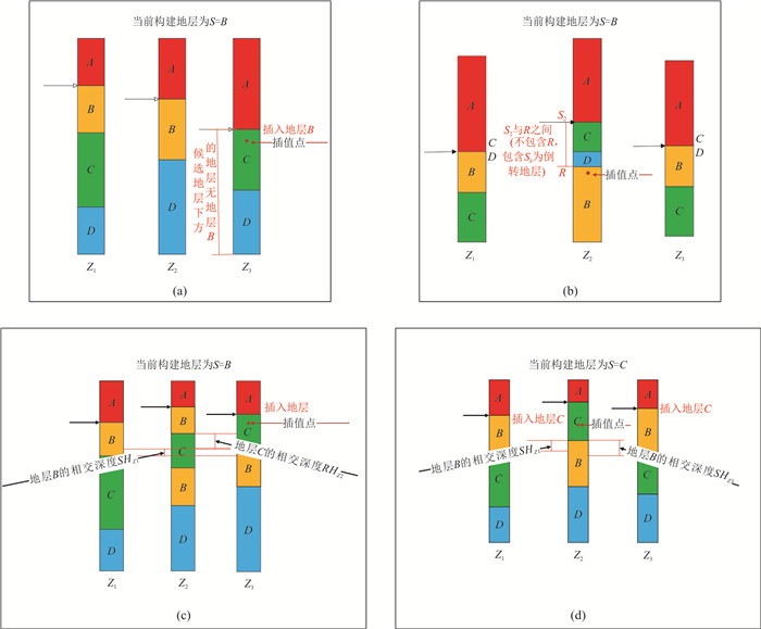
图 4 判定逻辑钻孔倒转地层的数学判别规则示例
Fig. 4. Example of mathematical discriminant rule to determine the inversion formation of logic borehole
图 10 含地层倒转的剖面图连接展示及对比实验
Fig. 10. Displaying and comparison test of section drawing with stratum inversion
表 1 各钻孔候选地层
Table 1. Candidate formations for drilling
$ {Z}_{1} $ $ {Z}_{2} $ $ {Z}_{3} $ $ {S}_{k} $ $ \mathrm{B} $ $ \mathrm{B} $ $ \mathrm{C} $  下载: 导出CSV
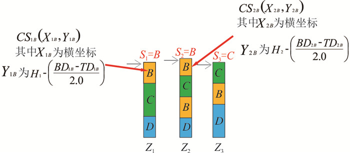
表 2 钻孔$ {Z}_{1} $及$ {Z}_{2} $的中心点坐标及深度取值范围
Table 2. Center point coordinates and depth range of boreholes $ {Z}_{1} $ and $ {Z}_{2} $
$ {Z}_{1} $ $ {Z}_{2} $ 候选地层 $ {S}_{1}=B $ $ {S}_{2}=B $ 中心点坐标 $ C{S}_{1B}({X}_{1B},{Y}_{1B}) $ $ C{S}_{2B}({X}_{2B},{Y}_{2B}) $ 深度取值范围 $ [{{S}_{1B}}_{\mathrm{m}\mathrm{i}\mathrm{n}},{{S}_{1B}}_{\mathrm{m}\mathrm{a}\mathrm{x}} $] $ [{{S}_{2B}}_{\mathrm{m}\mathrm{i}\mathrm{n}},{{S}_{2B}}_{\mathrm{m}\mathrm{a}\mathrm{x}} $] 并集范围 $ [{{S}_{1B}}_{\mathrm{m}\mathrm{i}\mathrm{n}},{{S}_{1B}}_{\mathrm{m}\mathrm{a}\mathrm{x}} $]U$ [{{S}_{2B}}_{\mathrm{m}\mathrm{i}\mathrm{n}},{{S}_{2B}}_{\mathrm{m}\mathrm{a}\mathrm{x}} $]
下载: 导出CSV
-
Che, D. F. , Jia, Q. R. , 2019. Three-Dimensional Geological Modeling of Coal Seams Using Weighted Kriging Method and Multi-Source Data. IEEE Access, 7: 118037-118045. https://doi.org/10.1109/ACCESS.2019.2936811 Chen, B. , Zhu, Y. B. , Zhang, Y. , 2020. Research on EVS-Based 3D Geological Modeling. High Speed Railway Technology, 11(6): 6-10, 18(in Chinese with English abstract). Dai, Y. , Dai, W. J. , 2022. Three-Dimensional Geological Modeling Based on Surfer FLAC3D and Its Verification. Geotechnical Investigation & Surveying, 50(3): 43-46(in Chinese with English abstract). Du, Z. C. , Liu, Z. , Ming, W. H. , et al. , 2019. Unified Stratigraphic Sequence Method for Three Dimensional Urban Geological Modeling. Rock and Soil Mechanics, 40(S1): 259-266(in Chinese with English abstract). Guo, J. T. , Wang, X. , Wang, J. , et al. , 2021. Three-Dimensional Geological Modeling and Spatial Analysis from Geotechnical Borehole Data Using an Implicit Surface and Marching Tetrahedra Algorithm. Engineering Geology, 284: 106047. https://doi.org/10.1016/j.enggeo.2021.106047 Hou, W. S. , Liu, H. G. , Zheng, T. C. , et al. , 2021. Hierarchical MPS-Based Three-Dimensional Geological Structure Reconstruction with Two-Dimensional Image(s). Journal of Earth Science, 32(2): 455-467. https://doi.org/10.1007/s12583-021-1443-x Jia, L. , 2021. Research on 3D Geological Modeling Based on GOCAD. Inner Mongolia Coal Economy, (7): 190-191(in Chinese with English abstract). doi: 10.3969/j.issn.1008-0155.2021.07.094 Kim, M. , Kim, H. S. , Chung, C. K. , 2020. A Three-Dimensional Geotechnical Spatial Modeling Method for Borehole Dataset Using Optimization of Geostatistical Approaches. KSCE Journal of Civil Engineering, 24(3): 778-793. https://doi.org/10.1007/s12205-020-1379-1 Li, J. , Wang, X. Y. , Liu, P. R. , et al. , 2022. Three-Dimensional Geological Hybrid Interpolation Method Combining Boreholes and Geological Sections. Journal of Zhengzhou University (Natural Science Edition), 54(3): 1-9(in Chinese with English abstract). Li, L. , Liu, X. G. , Wu, W. B. , 2018. Key Technology of 3D Stratum Modelling Based on Borehole Data. Rock and Soil Mechanics, 39(3): 1056-1062(in Chinese with English abstract). Li, N. , Li, C. B. , Chu, W. K. , et al. , 2021. Uncertainty Visualisation of a 3D Geological Geometry Model and Its Application in GIS-Based Mineral Resource Assessment: A Case Study in Huayuan District, Northwestern Hunan Province, China. Journal of Earth Science, 32(2): 358-369. https://doi.org/10.1007/s12583-021-1434-y Liu, L. , Yang, Z. , 2019. Comparative Study on Spatial Interpolation Methods of 3D Geological Modeling Based on Borehole Data. Energy Technology and Management, 44(3): 162-164(in Chinese with English abstract). doi: 10.3969/j.issn.1672-9943.2019.03.063 Liu, X. , Li, J. X. , Hu, L. T. , 2021.3D Geological Modeling of Complex Geological Mining Area Based on Multi-Source Data Fusion. Geotechnical Investigation & Surveying, 49(12): 35-39(in Chinese with English abstract). Liu, Z. , Zhang, Z. L. , Zhou, C. Y. , et al. , 2021. An Adaptive Inverse-Distance Weighting Interpolation Method Considering Spatial Differentiation in 3D Geological Modeling. Geosciences, 11(2): 51. https://doi.org/10.3390/geosciences11020051 Tang, B. Y. , Wu, C. L. , Li, X. C. , et al. , 2015. A Fast Progressive 3D Geological Modeling Method Based on Borehole Data. Rock and Soil Mechanics, 36(12): 3633-3638(in Chinese with English abstract). Wang, B. , He, K. , Zhong, D. Y. , 2021. Automatic Construction Method of Constraint Rules for Implicit Modeling of Geological Bodies Based on Borehole Data. Gold Science and Technology, 29(3): 345-354(in Chinese with English abstract). Wang, J. Y. , Cheng, Y. Y. , Ma, S. , et al. , 2021. City 3D Geological Model Based on Virtual Boreholes. Geotechnical Investigation & Surveying, 49(6): 46-52(in Chinese with English abstract). Xi, L. , Ni, Y. G. , He, J. , et al. , 2022. Three-Dimensional Geological Modeling and Resource Estimation of the Marine Sand and Gravel Orebodies Based on GMS. Geology and Exploration, 58(2): 429-441(in Chinese with English abstract). Yang, B. , Hu, H. F. , Zhao, P. F. , et al. , 2015. Multivariate Data-Based 3D Geological Modeling Study. Geology of Anhui, 25(4): 298-300, 317(in Chinese with English abstract). doi: 10.3969/j.issn.1005-6157.2015.04.013 Zhong, D. Y. , Wang, L. G. , Bi, L. , 2020. Extended Hermite Radial Basis Functions for Sparse Contours Interpolation. IEEE Access, 8: 58752-58762. https://doi.org/10.1109/ACCESS.2020.2982802 Zhong, D. Y. , Wang, L. G. , Lin, B. I. , et al. , 2019a. Implicit Modeling of Complex Orebody with Constraints of Geological Rules. Transactions of Nonferrous Metals Society of China, 29(11): 2392-2399. https://doi.org/10.1016/s1003-6326(19)65145-9 Zhong, D. Y. , Zhang, J. , Wang, L. G. , 2019b. Fast Implicit Surface Reconstruction for the Radial Basis Functions Interpolant. Applied Sciences, 9(24): 5335. https://doi.org/10.3390/app9245335 Zhong, P. , 2017. Research on 3D Geological Modeling Technology and Application Based on Virtual Drilling Technology. Modern Informationn Technology, 1(3): 100-101(in Chinese with English abstract). doi: 10.3969/j.issn.2096-4706.2017.03.041 Zou, J. C. , Hu, J. K. , Li, J. Y. , 2021. Research on 3D Geological Modeling of Mines Based on 3D Mine. Mineral Exploration, 12(3): 718-724(in Chinese with English abstract). doi: 10.3969/j.issn.1674-7801.2021.03.026 陈兵, 朱泳标, 张燕, 2020. 基于EVS的三维地质建模研究. 高速铁路技术, 11(6): 6-10, 18. https://www.cnki.com.cn/Article/CJFDTOTAL-GSTL202006002.htm 戴粤, 戴吾蛟, 2022. 基于Surfer平台的FLAC3D三维地质建模方法与模型验证. 工程勘察, 50(3): 43-46. https://www.cnki.com.cn/Article/CJFDTOTAL-GCKC202203007.htm 杜子纯, 刘镇, 明伟华, 等, 2019. 城市级三维地质建模的统一地层序列方法. 岩土力学, 40(增刊1): 259-266. https://www.cnki.com.cn/Article/CJFDTOTAL-YTLX2019S1039.htm 贾龙, 2021. 基于GOCAD的三维地质建模研究. 内蒙古煤炭经济, (7): 190-191. doi: 10.3969/j.issn.1008-0155.2021.07.094 李健, 王心宇, 刘沛溶, 等, 2022. 融合钻孔与地质剖面的三维地质混合插值方法. 郑州大学学报(理学版), 54(3): 1-9. https://www.cnki.com.cn/Article/CJFDTOTAL-ZZDZ202203001.htm 李璐, 刘新根, 吴蔚博, 2018. 基于钻孔数据的三维地层建模关键技术. 岩土力学, 39(3): 1056-1062. https://www.cnki.com.cn/Article/CJFDTOTAL-YTLX201803035.htm 刘乐, 杨智, 2019. 基于钻孔数据的三维地质建模空间插值方法的对比研究. 能源技术与管理, 44(3): 162-164. https://www.cnki.com.cn/Article/CJFDTOTAL-JSMT201903064.htm 刘鑫, 李季秀, 胡立堂, 2021. 基于多源数据融合的复杂地质矿区三维地质建模. 工程勘察, 49(12): 35-39. https://www.cnki.com.cn/Article/CJFDTOTAL-GCKC202112007.htm 唐丙寅, 吴冲龙, 李新川, 等, 2015. 一种基于钻孔地质数据的快速递进三维地质建模方法. 岩土力学, 36(12): 3633-3638. https://www.cnki.com.cn/Article/CJFDTOTAL-YTLX201512037.htm 王博, 贺康, 钟德云, 2021. 基于钻孔数据的地质体隐式建模约束规则自动构造方法. 黄金科学技术, 29(3): 345-354. https://www.cnki.com.cn/Article/CJFDTOTAL-HJKJ202103004.htm 王甲怡, 成远湲, 马莎, 等, 2021. 基于虚拟钻孔的城市三维地质模型构建方法. 工程勘察, 49(6): 46-52. https://www.cnki.com.cn/Article/CJFDTOTAL-GCKC202106010.htm 习龙, 倪玉根, 何健, 等, 2022. 基于GMS软件的海砂矿体三维地质建模和资源量估算. 地质与勘探, 58(2): 429-441. https://www.cnki.com.cn/Article/CJFDTOTAL-DZKT202202017.htm 杨波, 胡海风, 赵鹏飞, 等, 2015. 基于多元数据的三维地质建模研究. 安徽地质, 25(4): 298-300, 317. https://www.cnki.com.cn/Article/CJFDTOTAL-AHDZ201504014.htm 钟频, 2017. 基于虚拟钻孔技术的三维地质建模应用研究. 现代信息科技, 1(3): 100-101. https://www.cnki.com.cn/Article/CJFDTOTAL-XDXK201703042.htm 邹进超, 胡加昆, 李金勇, 2021. 基于3Dmine的矿山三维地质建模研究. 矿产勘查, 12(3): 718-724. https://www.cnki.com.cn/Article/CJFDTOTAL-YSJS202103026.htm -


 点击查看大图

计量
- 文章访问数: 1972
- HTML全文浏览量: 656
- PDF下载量: 67
- 被引次数: 0
