


Complex Orebody 3D Modeling Using Radial Basis Function Surface Incorporating Stacking Integration Strategy
-
摘要: 建立三维矿体模型是数字矿山、智慧矿山的基础.针对经典径向基函数曲面重建算法在原始数据稀疏时出现曲面边界自拟合及模型不连续现象,提出了一种集成多种机器学习模型的径向基函数曲面复杂矿体三维建模方法.该方法利用Stacking模型学习矿体轮廓线离散化点云数据的分布特征,建立表征矿体模型几何信息的有向点集;在此基础上提取边界点及法向量,通过Hermite型径向基函数建立隐式场,最后基于行进四面体算法建立三维矿体模型.与轮廓线拼接法、经典径向基函数曲面重建算法、简单克里金插值法相比,该方法能够有效减少曲面边界自拟合现象,减少模型多余孔洞,提高模型的连续性;建立的模型所切轮廓线与原始轮廓线相似度达75.14%,与人工干预程度较高的显式模型相当;在体积表征上与显式模型的差距达到最低.Abstract: Establishing a 3D orebody model is the foundation of digital mine and smart mine. In response to the phenomenon that the classical radial basis function surface reconstruction algorithm leads to surface boundary self-fitting and model discontinuity when the original data is sparse, this paper proposes a method of implicit automatic modeling of complex orebody with radial basis function incorporating multiple machine learning. This method uses the Stacking model to learn the distribution characteristics of the discrete point cloud data of the orebody contour lines to build a directed point set characterizing the geometric information of the orebody model. On this basis, the boundary points and normal vectors are extracted, the implicit field is established by the Hermite radial basis function, and finally the 3D orebody model is visualized based on the marching tetrahedron algorithm. The analysis was compared with the contour line splicing method, the classical radial basis function surface reconstruction algorithm, and the simple kriging interpolation method. The method can effectively reduce the phenomenon of self-fitting of surface boundaries, reduce redundant holes in the model, and improve the continuity of the model; the similarity between the contour lines cut by the established model and the original contour lines reaches 75.14%, which is comparable to the explicit model with a high degree of manual intervention; the gap between the model and the explicit model in volume characterization reaches the lowest.
-
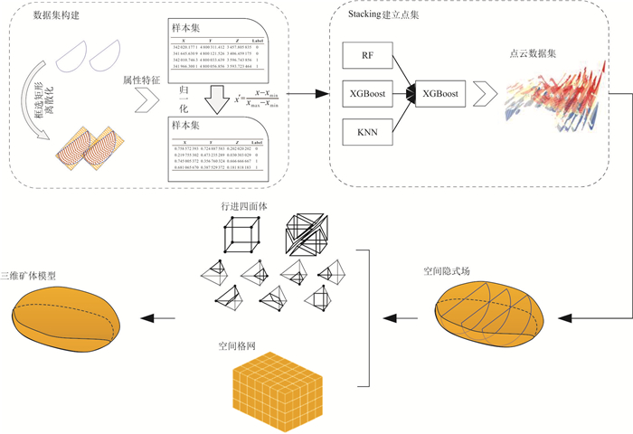
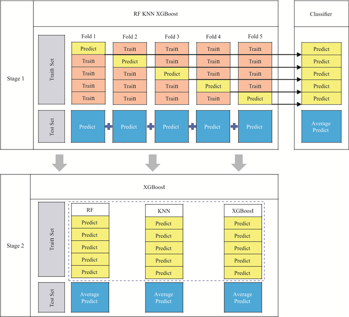
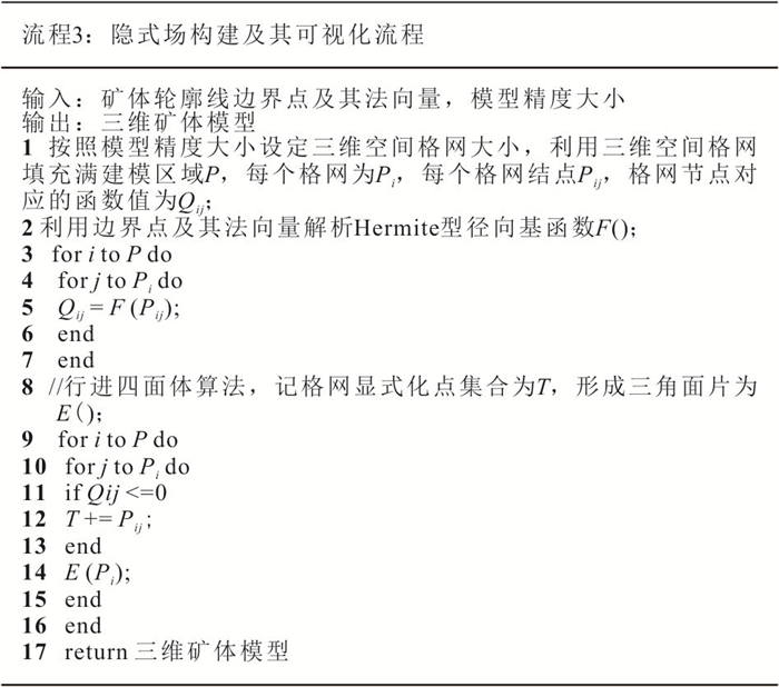
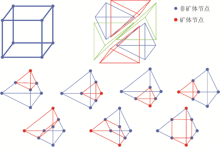
图 2 基于Stacking集成策略的隐式三维地质建模流程
Fig. 2. Implicit 3D geological modeling process based on Stacking integration strategy
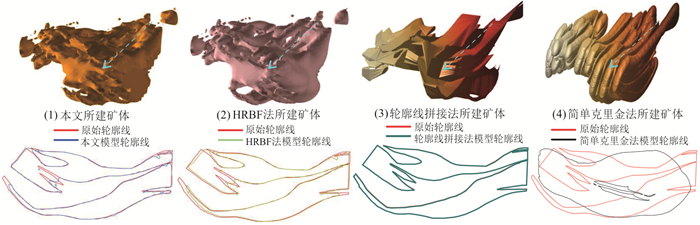
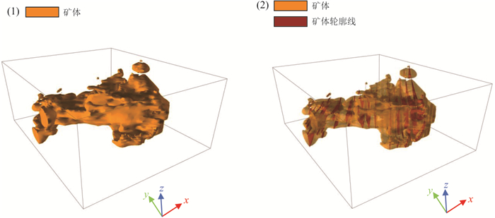
图 12 不同方法所建矿体模型
(1)为本文所建模型,(2)为HRBF法所建模型,(3)为轮廓线拼接法所建模型,(4)为简单克里金插值法所建模型
Fig. 12. Orebody models constructed by different methods
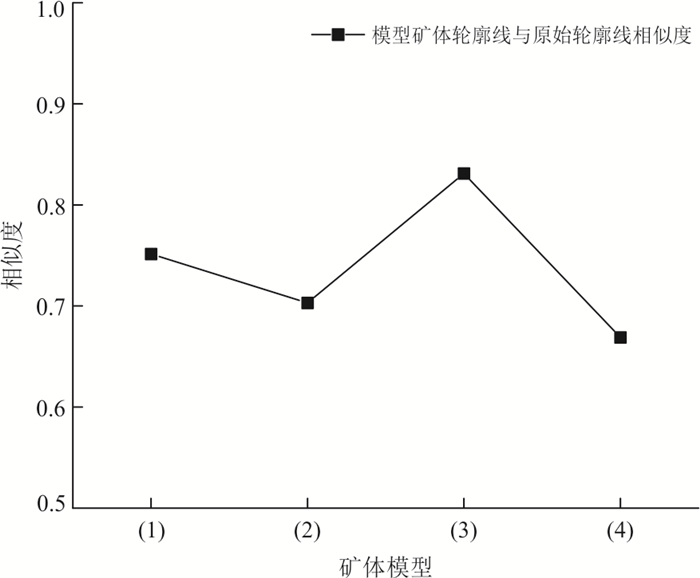
图 13 模型所切轮廓线与原始轮廓线相似度
Fig. 13. Similarity between the contour line cut by the model and the original contour line
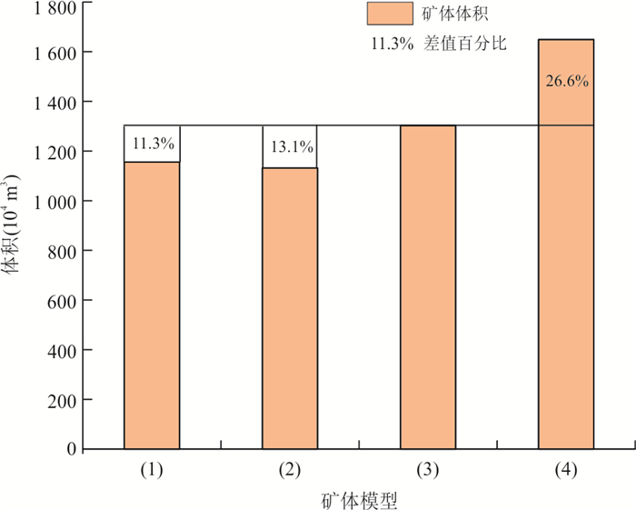
图 14 矿体模型体积对比
差值百分比计算公式:(轮廓线拼接法模型和其他模型体积之差/轮廓线拼接法模型体积)×100%(保留1位小数);(1)为本文所建模型,(2)为HRBF法所建模型,(3)为轮廓线拼接法所建模型,(4)为简单克里金插值法所建模型
Fig. 14. Orebody model volume comparison chart
表 1 Stacking集成策略各分类器超参数信息
Table 1. Stacking integration strategy hyperparameter information for each classifier
分类器 超参数 参数值 搜索范围 Stage 1 RF max_depth 15 [1, 50] Criterion ‘gini’ - n_estimators 300 [200, 300, 400] KNN n_neighbors 3 [1, 11] Weight ‘uniform’ [‘uniform’, ‘distance’] Algorithm ‘auto’ - XGBoost learning_rate 0.3 [0.1, 1] max_depth 6 [1, 10] n_estimators 100 [50, 100, 150, 200] Stage 2 XGBoost learning_rate 0.3 [0.1, 1] max_depth 6 [1, 10] n_estimators 100 [50, 100, 150, 200]  下载: 导出CSV
表 2 各分类器F1-score对比情况
Table 2. Comparison of F1-score of each classifier
类别 度量 RF KNN XGBoost Stacking 矿体 Precision 0.92 0.82 0.84 0.88 Recall 0.64 0.79 0.62 0.79 F1-score 0.75 0.80 0.72 0.83 岩石 Precision 0.87 0.92 0.86 0.92 Recall 0.98 0.93 0.95 0.96 F1-score 0.92 0.92 0.90 0.94
下载: 导出CSV
-
Apel, M., 2006. From 3D Geomodelling Systems towards 3D Geoscience Information Systems: Data Model, Query Functionality, and Data Management. Computers & Geosciences, 32(2): 222-229. https://doi.org/10.1016/j.cageo.2005.06.016 Bi, L., Zhao, H., Li, Y. L., 2018. Automatic 3D Orebody Modeling Based on Biased-SVM and Poisson Surface. Journal of China University of Mining & Technology, 47(5): 1123-1130 (in Chinese with English abstract). Calcagno, P., Chilès, J. P., Courrioux, G., et al., 2008. Geological Modelling from Field Data and Geological Knowledge. Physics of the Earth and Planetary Interiors, 171(1-4): 147-157. https://doi.org/10.1016/j.pepi.2008.06.013 Chen, T. Q., Guestrin, C., 2016. XGBoost: A Scalable Tree Boosting System. The 22nd ACM SIGKDD International Conference on Knowledge Discovery and Data Mining, San Francisco. Feito, F., Torres, J. C., Ureña, A., 1995. Orientation, Simplicity, and Inclusion Test for Planar Polygons. Computers & Graphics, 19(4): 595-600. https://doi.org/10.1016/0097-8493(95)00037-D Feng, C., Pan, J. G., Li, C., et al., 2023. Fault High-Resolution Recognition Method Based on Deep Neural Network. Earth Science, 48(8): 3044-3052 (in Chinese with English abstract). Geng, R. R., Fan, H. H., Sun, Y. Q., et al., 2020. 3D Quantitative Prediction of Shazijiang Uranium Deposit Based on GOCAD Software. Mineral Deposits, 39(6): 1078-1090 (in Chinese with English abstract). Guo, J. T., Liu, Y. H., Han, Y. F., et al., 2019. Implicit 3D Geological Modeling Method for Borehole Data Based on Machine Learning. Journal of Northeastern University (Natural Science), 40(9): 1337-1342 (in Chinese with English abstract). Guo, J. T., Wang, J. M., Wu, L. X., et al., 2020. Explicit-Implicit-Integrated 3-D Geological Modelling Approach: A Case Study of the Xianyan Demolition Volcano (Fujian, China). Tectonophysics, 795: 228648. https://doi.org/10.1016/j.tecto.2020.228648 Guo, J. T., Wu, L. X., Zhou, W. H., 2016. Automatic Ore Body Implicit 3D Modeling Based on Radial Basis Function Surface. Journal of China Coal Society, 41(8): 2130-2135 (in Chinese with English abstract). Huang, C., Lang, X. H., Lou, Y. M., et al., 2021. 3D Geological Modeling and Deep Visualization Application of Xiongcun No. Ⅰ Orebody, Tibet. Geological Bulletin of China, 40(5): 753-763 (in Chinese with English abstract). Jia, R., Lü, Y. K., Wang, G. W., et al., 2021. A Stacking Methodology of Machine Learning for 3D Geological Modeling with Geological-Geophysical Datasets, Laochang Sn Camp, Gejiu (China). Computers & Geosciences, 151: 104754. https://doi.org/10.1016/j.cageo.2021.104754 Li, F. S., Li, X. J., Chen, W. T., et al., 2022. Automatic Lithology Classification Based on Deep Features Using Dual Polarization SAR Images. Earth Science, 47(11): 4267-4279 (in Chinese with English abstract). Li, X. J., Hu, J. H., Zhu, H. H., et al., 2008. The Estimation of Coal Thickness Based on Kriging Technique and 3D Coal Seam Modeling. Journal of China Coal Society, 33(7): 765-769 (in Chinese with English abstract). Li, Z. L., Wu, C. L., Zhang, X. L., et al., 2013. Dynamical Ore-Body Modeling by Property-Structure (P-S) Method. Earth Science, 38(6): 1331-1338 (in Chinese with English abstract). Liu, Z., Zhang, Z. L., Zhou, C. Y., et al., 2021. An Adaptive Inverse-Distance Weighting Interpolation Method Considering Spatial Differentiation in 3D Geological Modeling. Geosciences, 11(2): 51. https://doi.org/10.3390/geosciences11020051 Macêdo, I., Gois, J. P., Velho, L., 2011. Hermite Radial Basis Functions Implicits. Computer Graphics Forum, 30(1): 27-42. https://doi.org/10.1111/j.1467-8659.2010.01785.x Pedregosa, F., Varoquaux, G., Gramfort, A., et al., 2012. Scikit-Learn: Machine Learning in Python. Journal of Machine Learning Research, 12: 2825-2830. Rodriguez-Galiano, V., Sanchez-Castillo, M., Chica-Olmo, M., et al., 2015. Machine Learning Predictive Models for Mineral Prospectivity: An Evaluation of Neural Networks, Random Forest, Regression Trees and Support Vector Machines. Ore Geology Reviews, 71: 804-818. https://doi.org/10.1016/j.oregeorev.2015.01.001 Shi, T. D., Zhong, D. Y., Wang, L. G., 2021. Geological Modeling Method Based on the Normal Dynamic Estimation of Sparse Point Clouds. Mathematics, 9(15): 1819. https://doi.org/10.3390/math9151819 Smirnoff, A., Boisvert, E., Paradis, S. J., 2008. Support Vector Machine for 3D Modelling from Sparse Geological Information of Various Origins. Computers & Geosciences, 34(2): 127-143. https://doi.org/10.1016/j.cageo.2006.12.008 Sun, J., Zhang, R. J., Chen, M. Q., et al., 2021. Real-Time Updating Method of Local Geological Model Based on Logging while Drilling Process. Arabian Journal of Geosciences, 14(9): 1-17. https://doi.org/10.1007/s12517-021-07034-1 Tai, W. X., Zhou, Q., Yang, C. F., et al., 2023. 3D Geological Visualization Modeling and Its Application in Zhexiang Gold Deposit, Southwest Guizhou Province. Earth Science, 48(11): 4017-4033 (in Chinese with English abstract). Wang, J. M., Zhao, H., Bi, L., et al., 2018a. Implicit 3D Modeling of Ore Body from Geological Boreholes Data Using Hermite Radial Basis Functions. Minerals, 8(10): 443. https://doi.org/10.3390/min8100443 Wang, M., Yang, J. L., Wang, X., et al., 2023. Identification of Shale Lithofacies by Well Logs Based on Random Forest Algorithm. Earth Science, 48(1): 130-142 (in Chinese with English abstract). Wang, X. D., Yang, S. C., Zhao, Y. F., et al., 2018b. Lithology Identification Using an Optimized KNN Clustering Method Based on Entropy-Weighed Cosine Distance in Mesozoic Strata of Gaoqing Field, Jiyang Depression. Journal of Petroleum Science and Engineering, 166: 157-174. https://doi.org/10.1016/j.petrol.2018.03.034 Wolpert, D. H., 1992. Stacked Generalization. Neural Networks, 5(2): 241-259. https://doi.org/10.1016/S0893-6080(05)80023-1 Wu, L. X., Wang, Y. J., Ding, E. J., et al., 2012. Thirdly Study on Digital Mine: Serve for Mine Safety and Intellimine with Support from IoT. Journal of China Coal Society, 37(3): 357-365 (in Chinese with English abstract). Xu, G., Wang, C. H., 2013. Complex Geological Object Visualization and Numerical Modeling for Wanjiakou Hydropower Station. Engineering Journal of Wuhan University, 46(4): 469-474 (in Chinese with English abstract). Xuan, W., Hua, X. H., Zou, J. G., et al., 2019. A New Method of Normal Estimation for Point Cloud Based on Adaptive Optimal Neighborhoods. Science of Surveying and Mapping, 44(10): 101-108, 116 (in Chinese with English abstract). Zhang, M. L., Zhou, Z. H., 2007. ML-KNN: A Lazy Learning Approach to Multi-Label Learning. Pattern Recognition, 40(7): 2038-2048. https://doi.org/10.1016/j.patcog.2006.12.019 Zhang, Q. F., Wan, B., Cao, Z. X., et al., 2021. Exploring the Potential of Unmanned Aerial Vehicle (UAV) Remote Sensing for Mapping Plucking Area of Tea Plantations. Forests, 12(9): 1214. https://doi.org/10.3390/f12091214 Zhang, S., Ding, E. J., Zhao, X. H., et al., 2007. Digital Mine and Constructing of Its Two Basic Platforms. Journal of China Coal Society, 32(9): 997-1001 (in Chinese with English abstract). Zhang, X. L., Wu, C. L., Zhou, Q., et al., 2020. Multi-Scale 3D Modeling and Visualization of Super Large Manganese Ore Gathering Area in Guizhou China. Earth Science, 45(2): 634-644 (in Chinese with English abstract). Zhong, D. Y., Wang, L. G., Bi, L., et al., 2019. Implicit Modeling of Complex Orebody with Constraints of Geological Rules. Transactions of Nonferrous Metals Society of China, 29(11): 2392-2399. https://doi.org/10.1016/S1003-6326(19)65145-9 Zhou, J., Wang, G. H., Cui, Y. L., et al., 2017. Three-Dimensional Modeling of Orebody Morphology in the Anba Section of the Yangshan Gold Deposit Based on 3D Mine. Geology and Exploration, 53(2): 390-397 (in Chinese with English abstract). 毕林, 赵辉, 李亚龙, 2018. 基于Biased-SVM和Poisson曲面矿体三维自动建模方法. 中国矿业大学学报, 47(5): 1123-1130. https://www.cnki.com.cn/Article/CJFDTOTAL-ZGKD201805021.htm 丰超, 潘建国, 李闯, 等, 2023. 基于深度神经网络的断层高分辨率识别方法. 地球科学, 48(8): 3044-3052. doi: 10.3799/dqkx.2022.276 耿瑞瑞, 范洪海, 孙远强, 等, 2020. 基于GOCAD软件的沙子江铀矿床三维定量预测. 矿床地质, 39(6): 1078-1090. https://www.cnki.com.cn/Article/CJFDTOTAL-KCDZ202006008.htm 郭甲腾, 刘寅贺, 韩英夫, 等, 2019. 基于机器学习的钻孔数据隐式三维地质建模方法. 东北大学学报(自然科学版), 40(9): 1337-1342. https://www.cnki.com.cn/Article/CJFDTOTAL-DBDX201909021.htm 郭甲腾, 吴立新, 周文辉, 2016. 基于径向基函数曲面的矿体隐式自动三维建模方法. 煤炭学报, 41(8): 2130-2135. https://www.cnki.com.cn/Article/CJFDTOTAL-MTXB201608034.htm 黄超, 郎兴海, 娄渝明, 等, 2021. 西藏雄村Ⅰ号矿体三维地质建模与深部可视化应用. 地质通报, 40(5): 753-763. https://www.cnki.com.cn/Article/CJFDTOTAL-ZQYD202105010.htm 李发森, 李显巨, 陈伟涛, 等, 2022. 基于深度特征的双极化SAR遥感图像岩性自动分类. 地球科学, 47(11): 4267-4279. doi: 10.3799/dqkx.2022.129 李晓军, 胡金虎, 朱合华, 等, 2008. 基于Kriging方法的煤层厚度估计及三维煤层建模. 煤炭学报, 33(7): 765-769. https://www.cnki.com.cn/Article/CJFDTOTAL-MTXB200807009.htm 李章林, 吴冲龙, 张夏林, 等, 2013. 属性‒结构(P-S)矿体动态建模方法. 地球科学, 38(6): 1331-1338. doi: 10.3799/dqkx.2013.000 邰文星, 周琦, 杨成富, 等, 2023. 黔西南者相金矿床三维地质可视化建模及应用. 地球科学, 48(11): 4017-4033. doi: 10.3799/dqkx.2022.095 王民, 杨金路, 王鑫, 等, 2023. 基于随机森林算法的泥页岩岩相测井识别. 地球科学, 48(1): 130-142. doi: 10.3799/dqkx.2022.181 吴立新, 汪云甲, 丁恩杰, 等, 2012. 三论数字矿山: 借力物联网保障矿山安全与智能采矿. 煤炭学报, 37(3): 357-365. https://www.cnki.com.cn/Article/CJFDTOTAL-MTXB201203002.htm 许国, 王长海, 2013. 万家口水电站复杂地质体三维模型及其数值模型构建. 武汉大学学报(工学版), 46(4): 469-474. https://www.cnki.com.cn/Article/CJFDTOTAL-WSDD201304012.htm 宣伟, 花向红, 邹进贵, 等, 2019. 自适应最优邻域尺寸选择的点云法向量估计方法. 测绘科学, 44(10): 101-108, 116. https://www.cnki.com.cn/Article/CJFDTOTAL-CHKD201910015.htm 张申, 丁恩杰, 赵小虎, 等, 2007. 数字矿山及其两大基础平台建设. 煤炭学报, 32(9): 997-1001. https://www.cnki.com.cn/Article/CJFDTOTAL-MTXB200709022.htm 张夏林, 吴冲龙, 周琦, 等, 2020. 贵州超大型锰矿集区的多尺度三维地质建模. 地球科学, 45(2): 634-644. doi: 10.3799/dqkx.2018.384 周洁, 王根厚, 崔玉良, 等, 2017. 基于3D Mine的阳山金矿安坝矿段三维建模研究及矿体形态分析. 地质与勘探, 53(2): 390-397. https://www.cnki.com.cn/Article/CJFDTOTAL-DZKT202401019.htm -


 点击查看大图
计量
- 文章访问数: 1391
- HTML全文浏览量: 563
- PDF下载量: 60
- 被引次数: 0
