




A Multilevel Optimization Framework for Off-Road Path Planning Incorporating Multiscale Geomechanical Constraints and Integrated Soil Modeling
-
摘要: 越野路径规划在应急救援等特殊场景任务中具有重要战略价值,但现有模型在复杂地形中存在通行性模型精度不足与求解效率低下的问题.为此,基于地质力学约束和融合土壤建模的思想,构建了通行性评估支撑的越野路径规划模型.首先,引入土壤湿度-硬度经验模型(SMSP Ⅱ)预测土壤额定圆锥系数(rating cone index,RCI),结合车辆额定圆锥指数(vehicle cone index,VCI),构建多要素约束且融合土壤通行性指标的通行度栅格图;在此基础上,提出一种融合分治策略与启发式搜索的改进NSGA-Ⅱ算法,并与Dijkstra算法集成,构建了多级混合路径优化框架.研究结果表明,论文提出的模型在路径可行性保持不变的前提下,计算效率提升约45%,路径通行度提升2%,路径长度缩短约2.1%.研究验证了论文提出的技术方法体系在复杂地质环境下越野路径规划的优越性能.Abstract: Off-road path planning plays a strategically important role in special mission scenarios such as emergency rescue. However, existing algorithmic models often suffer from low accuracy in passability modeling and poor computational efficiency in complex terrains. To improve planning accuracy and efficiency, this study introduces the Soil Moisture-Strength Prediction model (SMSP Ⅱ) to estimate the rated cone index (RCI) of soil, and combines it with the vehicle cone index (VCI) to construct a traversability grid map that integrates multiple constraints and soil passability indicators. On this basis, an improved NSGA-Ⅱ algorithm is proposed, incorporating a divide-and-conquer strategy and heuristic search, and is further integrated with the Dijkstra algorithm to build a multi-level hybrid path optimization framework. Experimental results demonstrate that the proposed method improves computational efficiency by approximately 45%, enhances path passability by 2%, and reduces path length by about 2.1%, while maintaining path feasibility. The findings verify the superior performance of the proposed technical framework for off-road path planning in complex geological environments.
-
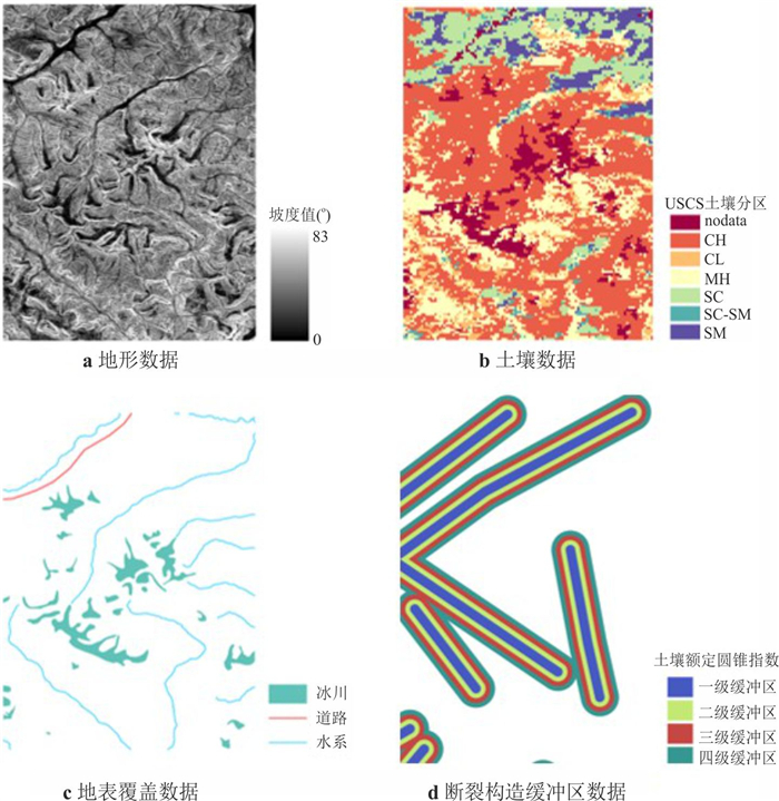
图 1 越野机动环境构建数据
地形、地表覆盖、断裂构造数据来源于遥感数据解译,土壤数据来自SoilGrids2.0平台的空间分辨率为250 m的数据集.b图土壤数据中:CH.高塑性黏土;CL.低塑性黏土;MH.高塑性粉土;SC.黏土质砂;SC-SM.含粉土的黏土质砂;SM.粉土质砂
Fig. 1. Off-road mobility environment construction data
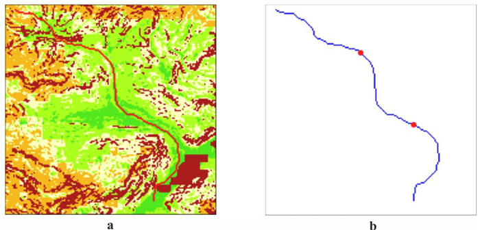
图 6 全局路径规划
a图为Dijkstra算法在90m空间分辨率通行度栅格图中全局路径规划结果;b图蓝色线代表全局规划路径,红色点代表在全局规划路径上的分段点.
Fig. 6. Large-scale global route planning
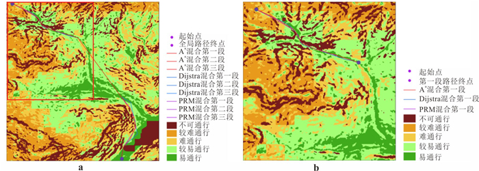
图 7 不同算法路径对比
a图为A*、Dijkstra、改进PRM 3种不同改进混合算法全局路径规划结果;b图为3种算法在采取分段策略后第一段路径规划结果,红色框区域为b图路径规划区域
Fig. 7. Path comparison of different algorithms
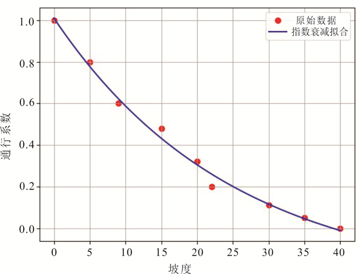
表 1 多项式插值与指数衰减插值模型效果对比
Table 1. Performance comparison between polynomial inter-polation and exponential decay interpolation models
模型 MSE R2 三次多项式 0.000 196 0.998 4 指数衰减 0.000 103 0.999 1  下载: 导出CSV
表 2 地质灾害胁迫缓冲区量化
Table 2. Quantitative analysis of geological hazard threat buffer zones
缓冲距离(m) 通行度系数 0~300 0.10 300~600 0.25 600~900 0.50 900~1 200 0.75 1 200以上 1.00
下载: 导出CSV
表 3 土壤类型通行量化
Table 3. Quantitative analysis of soil type traversability
USCS分类 通行评级 通行度系数 CH 差(Poor) 0.50 CL 中等(Fair) 0.65 CL⁃ML 中等(Fair) 0.60 MH 差(poor) 0.55 ML 中等(Fair) 0.70 SC 良好(Good) 0.85 SC⁃SM 中等(Fair) 0.80 SM 中等(Fair) 0.75 SP 良好(Good) 0.95 SP⁃SM 中等(Fair) 0.90 注:本研究首次将USCS工程分类与RCI阈值联合用于越野通行评级; CH.高塑性黏土; CL.低塑性黏土; CL⁃ML.低塑性粉质黏土; MH.高塑性粉土; ML.低塑性粉土; SC.黏土质砂; SC⁃SM.含粉土的黏土质砂; SM.粉土质砂; SP.级配不良砂; SP⁃SM.含粉土的级配不良砂.
下载: 导出CSV
表 4 栅格合并算法
Table 4. Raster merging process workflow
算法1 栅格合并算法过程 输入:栅格文件 步骤1读取文件、计算output_rows、output_cols 步骤2 for i in长度out_rows按行遍历 for j in长度out_clos按列遍历 Windows获取,规则判断: 如果不可通行栅格占优,合并栅格不可通行 否则,可通行栅格平均值赋值给中心点 步骤3 Return output文件
下载: 导出CSV
表 5 算法参数
Table 5. Algorithm parameters
参数名称 参数值 population 200 generations 300 Crossover_rate 0.5 Mutation_rate 0.5 resolution 30 obstacle_penalty 106
下载: 导出CSV
表 6 A*与Dijkstra算法全局规划性能对比
Table 6. Performance comparison between A* and Dijkstra algorithms for global path planning
算法 路径栅格数 总距离(km) 平均通
行度算法平均时间(s) A*算法 211 22.18 0.642 4.210 7 Dijkstra算法 211 22.36 0.771 0.544 2
下载: 导出CSV
表 7 全局规划与分段规划对比
Table 7. Performance comparison between global and segmented planning approaches
路径方法 搜索栅格数 平均通行度 路径距离(km) 全局规划 91 351 0.629 19.647 分段规划 50 305 0.642 19.234
下载: 导出CSV
表 8 不同算法性能对比
Table 8. Algorithm performance comparison
算法 搜索栅格数 平均通行度 路径距离(m) A*+改进NSGA⁃Ⅱ 50 305 0.642 19 234.00 Dijkstra+改进NSGA⁃Ⅱ 165 967 0.663 19 516.46 PRM+改进NSGA⁃Ⅱ - 0.635 19 521.17
下载: 导出CSV
-
Chen, W. T., Xu, J. H., Wang, R., et al., 2025. Hyperspectral Remote Sensing Inversion of Black Soil Organic Matter Content Based on Multi-Scale Feature Enhancement. Earth Science, 50(12): 4909-4918. doi: 10.3799/dqkx.2025.154 Cui, W., Liu, G., Yu, F., et al., 2020. Appropriate Buffer Distance Size for Correlation Analysis between Chasm and Landslide Based on Buffer GIS. Journal of Jiamusi University (Natural Science Edition), 38(1): 4-8(in Chinese with English abstract). Deb, K., Pratap, A., Agarwal, S., et al., 2002. A Fast and Elitist Multiobjective Genetic Algorithm: NSGA⁃Ⅱ. IEEE Transactions on Evolutionary Computation, 6(2): 182-197. https://doi.org/10.1109/4235.996017 Dijkstra, E. W., 1959. A Note on Two Problems in Connexion with Graphs. Numerische Mathematik, 1(1): 269-271. https://doi.org/10.1007/BF01386390 Fan, L. L., Qiu, D. N., Cao, Z., et al., 2022. Research on Cross Country Shortest Path Planning Based on Optimized A* Algorithm. Geospatial Information, 20(6): 71-73, 105(in Chinese with English abstract). Gai, S., Wu, C. H., Ma, L. L., et al., 2020. Research on Path Planning Simulation Model of Mobile Unit in Land Battlefield. Command Control Simulation, 42(3): 27-32(in Chinese with English abstract). Gao, H. C., Lian, Y., Ren, Y. Q. Q., et al., 2024. Vehicles Trafficability Considering Cone Index and Multi⁃Scale Terrain Dependence: Case on Xizang Autonomous Region. Journal of Tianjin Normal University (Natural Science Edition), 44(3): 60-67(in Chinese with English abstract). Han, G., Zhao, C. X., 2008. Traversability Classification Based on Multi⁃Visual Features Fusion. Journal of Huazhong University of Science and Technology (Natural Science Edition), 36(Suppl.1): 105-108(in Chinese with English abstract). Hart, P. E., Nilsson, N. J., Raphael, B., 1968. A Formal Basis for the Heuristic Determination of Minimum Cost Paths. IEEE Transactions on Systems Science and Cybernetics, 4(2): 100-107. https://doi.org/10.1109/TSSC.1968.300136 He, X. G., Yuan, J. Y., Lai, X. Y., et al., 2004 Military Topography. Training and Technology, 25(2): 58-59 (in Chinese with English abstract). Huang, L. F., 2008. A Study of the Comprehensive Analysis of Natural Environmental Factors in Battlefield Based on GIS (Dissertation). PLA Information Engineering University, Zhengzhou(in Chinese with English abstract). Li, H., Liu, X. Q., 2011. Summary of Evaluating the Mobility of Vehicle Based on Cone Index. Agricultural Equipment Vehicle Engineering, 49(7): 16-20(in Chinese with English abstract). Li, K. W., You, X., Zhang, X., et al., 2018. Evaluation of Soil Trafficability Based on Multi⁃Source Data. Journal of Geomatics Science and Technology, 35(2): 206-210(in Chinese with English abstract). Li, T. Q., 2021. Accessible Area Modeling and Path Calculation for Vehicle Field Path Planning (Dissertation). Liaoning Technical University, Fuxin(in Chinese with English abstract). Li, Y., Zhou, Y., Lei, X., et al., 2019. Simulation of Quantitative Relationship between Positive and Negative Topographic Factors of Loess Based on Catchment Unit. Journal of Arid Land Resources and Environment, 33(7): 78-84(in Chinese with English abstract). Liu, H. J., Lu, J. F., Yang, J. Y., 2006. Rough Terrain Traversability Analysis Based on Relative Features. Journal of Data Acquisition Processing, 21(1): 58-63(in Chinese with English abstract). Poggio, L., de Sousa, L. M., Batjes, N. H., et al., 2021. SoilGrids 2.0: Producing Soil Information for the Globe with Quantified Spatial Uncertainty. Soil, 7(1): 217-240. https://doi.org/10.5194/soil⁃7⁃217⁃2021 Schreier, H., Lavkulich, L. M., 1978. A Numerical Terrain Classification Scheme for Off⁃Road Terrain Trafficability Assessments. Geoforum, 9(3): 225-234. https://doi.org/10.1016/0016⁃7185(78)90012⁃X Song, C. Y., 2005. Research on Cross⁃Country Path Planning of ALV Based on Simulate Anneal Algorithm(Dissertation). National University of Defense Technology, Changsha(in Chinese with English abstract). Song, W. H., Tan, Q. L., Xia, Y., et al., 2020. Three⁃Dimensional Terrain Construction and Lightweight of Railway Line Engineering Ribbon Corridor. Railway Computer Application, 29(1): 29-33(in Chinese with English abstract). Sullivan, P. M., Bullock, C. D., Renfroe, N. A., et al., 1997. Soil Moisture Strength Prediction Model Version Ⅱ (SMSP Ⅱ) (Tech. Rep. GL⁃97⁃15). Vicksburg, MS: US Army Waterways Experiment Station, U. S. A. . Sun, Y. Z., 2020. Global Path Planning and Trajectory Tracking of Unmanned Wheeled Vehicles on Terrains(Dissertation). Jilin University, Changchun(in Chinese with English abstract). Wang, Q. S., Zhu, C. Q., Zhang, Z., 2007. An Optimal Algorithm for Shortcut Problem in Channel Analysis. Journal of Zhengzhou Institute of Surveying and Mapping, 24(4): 291-293(in Chinese with English abstract). Wang, R. Z., Wan, S. Y., Chen, W. T., et al., 2024. A Novel Finer Soil Strength Mapping Framework Based on Machine Learning and Remote Sensing Images. Computers Geosciences, 182: 105479. https://doi.org/10.1016/j.cageo.2023.105479 Wu, T. Y., Xu, J. H., Liu, J. Y., et al., 2013. Research of Cross⁃Country Path Planning Based on Improved A* Algorithm. Application Research of Computers, 30(6): 1724-1726(in Chinese with English abstract). Yuan, R. J., Chen, G., Wang, B. B., 2017. Analysis of Influence of Terrain Slope on Off⁃Road Maneuvering Time. Geomatics World, 24(6): 87-91(in Chinese with English abstract). Zhang, H. D., Zheng, R., Cen, Y. W., 2005. Present Situation and Future Development of Mobile Robot Path Planning Technology. Journal of System Simulation, 17(2): 439-443(in Chinese with English abstract). Zhang, H. F., Wang, M. X., Wu, C. H., 2018. A Method of Force Maneuvering Path Planning with Improved a Algorithm. Journal of Geomatics Science and Technology, 35(5): 529-532, 539(in Chinese with English abstract). Zhang, J. X., Liu, J., 1997. A New Method for Terrain Modeling. Signal Processing, 13(4): 369-373(in Chinese with English abstract). Zhang, W. S., Dong, C. Q., 1996. Study on Terrain Traffic Performance. Journal of Geomatics Science and Technology, 13(2): 143-147(in Chinese with English abstract). 陈伟涛, 徐佳辉, 王锐, 等, 2025. 基于多尺度特征增强的黑土有机质含量高光谱卫星遥感反演. 地球科学, 50(12): 4909-4918. doi: 10.3799/dqkx.2025.154 崔伟, 刘高, 于飞, 等, 2020. 基于缓冲区GIS断层和滑坡相关性分析中缓冲距离大小选取分析. 佳木斯大学学报(自然科学版), 38(1): 4-8. 范林林, 邱德楠, 曹震, 等, 2022. 基于优化A*算法的越野最短路径规划研究. 地理空间信息, 20(6): 71-73, 105. 盖森, 吴从晖, 马雷雷, 等, 2020. 陆战场机动单元路径规划仿真模型研究. 指挥控制与仿真, 42(3): 27-32. 高晖春, 连懿, 任杨千千, 等, 2024. 基于圆锥指数与多尺度地形因子的车辆通行性研究: 以西藏自治区为例. 天津师范大学学报(自然科学版), 44(3): 60-67. 韩光, 赵春霞, 2008. 融合多可视化特征的可通行性地形分类. 华中科技大学学报(自然科学版), 36(增刊1): 105-108. 何西刚, 袁家喻, 赖学勇, 等, 2004. 军事地形学. 训练与科技, 25(2): 58-59. 黄鲁峰, 2008. 基于GIS的战场自然环境因子综合分析研究(硕士学位论文). 郑州: 解放军信息工程大学. 李灏, 刘新全, 2011. 基于圆锥指数评估车辆机动性能综述. 农业装备与车辆工程, 49(7): 16-20. 李坤伟, 游雄, 张欣, 等, 2018. 基于多源数据的土壤越野通行性评估. 测绘科学技术学报, 35(2): 206-210. 李天琪, 2021. 面向车辆野外路径规划的可通行区域建模与路径计算(硕士学位论文). 阜新: 辽宁工程技术大学. 李阳, 周毅, 雷雪, 等, 2019. 基于流域单元的黄土地貌正负地形因子量化关系模拟. 干旱区资源与环境, 33(7): 78-84. 刘华军, 陆建峰, 杨静宇, 2006. 基于相对特征的越野地形可通行性分析. 数据采集与处理, 21(1): 58-63. 宋彩云, 2005. 基于模拟退火的ALV越野路径规划研究(硕士学位论文). 长沙: 国防科学技术大学. 宋伟华, 谭衢霖, 夏宇, 等, 2020. 线路工程带状走廊三维地形构建及轻量化研究. 铁路计算机应用, 29(1): 29-33. 孙玉泽, 2020. 无人轮式车辆越野路面全局路径规划与轨迹跟踪(硕士学位论文). 长春: 吉林大学. 王奇胜, 朱长青, 张真, 2007. 越野通道最短路径分析的优化算法. 测绘科学技术学报, 24(4): 291-293. 吴天羿, 许继恒, 刘建永, 等, 2013. 基于改进A*算法的越野路径规划研究. 计算机应用研究, 30(6): 1724-1726. 袁仁进, 陈刚, 王冰冰, 2017. 地形坡度对越野机动时间影响分析. 地理信息世界, 24(6): 87-91. 张捍东, 郑睿, 岑豫皖, 2005. 移动机器人路径规划技术的现状与展望. 系统仿真学报, 17(2): 439-443. 张涵斐, 王明孝, 吴超辉, 2018. 一种利用改进A算法的部队机动路径规划. 测绘科学技术学报, 35(5): 529-532, 539. 张继贤, 柳健, 1997. 地形数学模型建立的新方法. 信号处理, 13(4): 369-373. 张文诗, 董成全, 1996. 地形通行性能的研究. 解放军测绘学院学报, 13(2): 143-147. -

 点击查看大图
计量
- 文章访问数: 446
- HTML全文浏览量: 15
- PDF下载量: 55
- 被引次数: 0
