


Intelligent Monitoring and Distribution Characteristics of Seismic Activity in Huai'an Salt Mining Area, Jiangsu Province
-
摘要: 淮安地区2021年小震活动短期内显著增强,为解答该地区地震活动与盐矿开采的关系,覆盖盐矿区加密布设了由54个短周期地震仪组成的台阵,开展了为期一年的地震观测.利用深度学习地震自动检测方法,并经绝对和相对重新定位后,构建的矿区高分辨地震目录,极大提升了矿区微小地震位置尤其是震源深度的定位精准性,有效提升了对小尺度盐矿区地震活动的监测能力.结合该区工业生产背景和地质情况,得出以下主要认识:矿区以微震活动为主,在空间上呈两个震群分布,1号震群位于盐井下方,震源深度上明显浅于2号震群;2号震群位于距盐井数公里的地表涌水区,时间上滞后于1号震群约8个月.据分析判断,1号震群可能与开采活动直接相关,而2号震群可能与流体扩散引起的局部断层活化有关.该研究表明,基于覆盖矿区、密集布设的台阵和智能检测技术,可极大提升对盐矿区微小地震活动分布特征及发震机理的认识,为盐矿区优化生产管控方案提供关键依据.Abstract: In 2021, the small earthquake activity significantly increased in the short term. To investigate the relationship between seismic activity and salt mining in the region, it deployed a dense array of 54 short period seismographs in the salt mining area and carried out a one-year microseismic monitoring. The high-resolution earthquake catalog for mining areas, constructed using deep learning earthquake automatic detection methods and absolute and relative repositioning, greatly improves the accuracy of locating the epicenter position, especially the depth of the earthquake source, of small earthquakes in mining areas, effectively enhancing the monitoring ability of seismic activity in small-scale salt mining areas. Combined with the industrial production background and geological conditions of the area, the following main understandings are obtained. The mining area is mainly characterized by microseismic activity, which is distributed in two independent earthquake clusters in space. The cluster 1 is located below the salt well, with a significantly shallower depth of the earthquake source than the cluster 2. The cluster 2 is located in the surface water inflow area that several kilometers far from the salt well, and lags behind the cluster 1 by about 8 months in time. After analysis, it is possible that the cluster 1 is directly related to mining activities, while the cluster 2 may be related to local fault activation caused by fluid diffusion. This study indicates that based on dense array covering mining areas and intelligent detection technology, the understanding of the distribution characteristics and seismic mechanisms of small earthquakes in salt mining areas can be greatly improved, which can provide key basis for optimizing production control plans.
-
Key words:
- artificial intelligence /
- earthquake detection /
- inducing seismic activity /
- seismic hazard /
- seismology
-
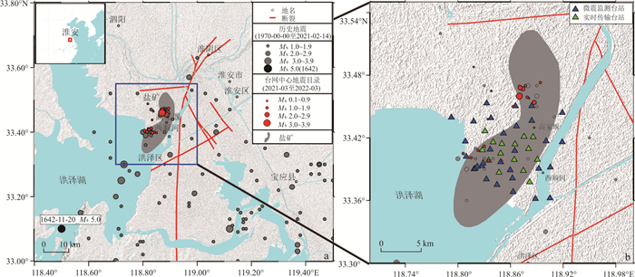
图 1 (a)研究区的主要断层和地震活动以及(b)台站分布
灰色实心圆表示历史地震,红色实心圆表示中国数字地震台网(CDSN)在本研究观测期内记录到的地震.灰色阴影表示淮安盐矿区(舒福明,2004)
Fig. 1. (a) Main faults and seismic activity of the study area, and (b) observation stations distribution
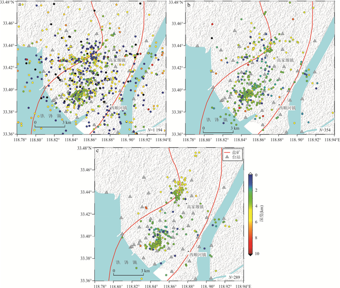
图 2 (a)REAL、(b)Hypoinverse和(c)HypoDD方法给出的地震位置
Fig. 2. Earthquake locations determined by (a) REAL, (b) Hypoinverse, and (c) HypoDD methods
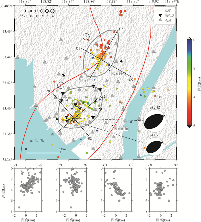
图 3 微震监测台阵地震相对定位震源分布
Fig. 3. Relative earthquake location distribution obtained from the microseismic monitoring array
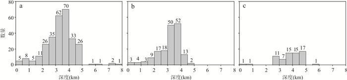
图 4 地震监测台阵相对定位震源深度分布
a.全部震源;b.1号震群;c.2号震群
Fig. 4. Focal depth distribution of earthquakes detected by the microseismic monitoring array
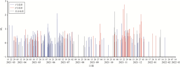
图 5 微震监测台阵相对定位震源M-T图
Fig. 5. Magnitude-time (M-T) diagram of earthquake locations obtained from the microseismic monitoring array
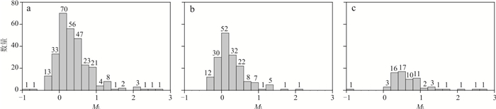
图 6 地震监测台阵相对定位震源震级分布
a.全部震源;b.1号震群;c.2号震群
Fig. 6. Magnitude distribution of earthquake locations detected by the microseismic monitoring array
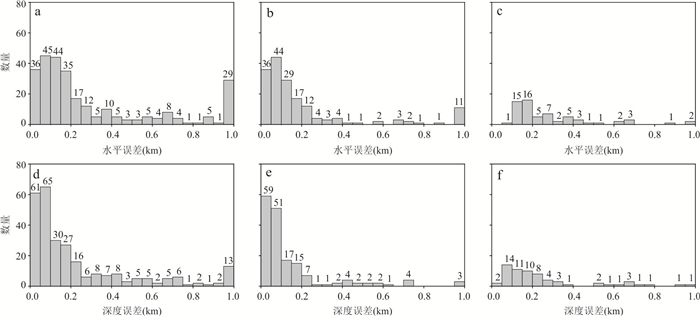
图 7 地震监测台阵相对定位水平和深度误差分布
a、d.全部震源;b、e.1号震群;c、f.2号震群
Fig. 7. Distribution of horizontal and depth errors in earthquake relative location estimates for the microseismic monitoring array
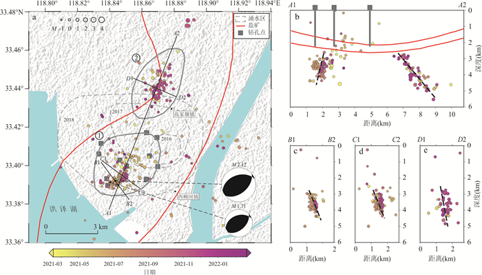
图 8 微震监测台阵地震相对定位震源时间分布(a)和剖面上的事件投影分布(b~e)
a. 灰色虚线分别表示2016年、2017年和2018年盐矿区的涌水范围(修改自王岩生和胡新兆,2019);红线表示盐矿分布形态(舒福明,2004). A1A2、B1B2、C1C2和D1D2上的黑色虚线表示可能存在隐伏断层
Fig. 8. Distribution of earthquake origin times relative to location, as detected by the microseismic monitoring array (a) and vents projection on profiles (b-e)
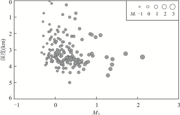
图 9 1号震群震源震级‒深度分布
Fig. 9. Magnitude-depth distribution of earthquakes within Cluster 1
表 1 定位中使用的速度模型
Table 1. Velocity model used in location
顶层深度(km) P波速度(km/s) S波速度(km/s) 0.00 2.663 9 1.046 0.70 3.018 0 1.185 0.90 3.445 8 1.353 1.80 3.692 9 1.450 2.40 3.920 4 1.539 3.00 4.00 2.250 5.00 6.10 3.430 10.00 6.20 3.480 20.00 6.30 3.540 27.00 6.50 3.650 30.00 6.80 3.820  下载: 导出CSV
表 2 HASH方法获得的震源机制解
Table 2. Focal mechanism solution obtained by HASH method
发震时刻 经度(°) 纬度(°) 深度(km) 震级 走向(°) 倾角(°) 滑动角(°) 残差 2021.06.30 07:19:48.7 118.844 33.392 3.44 2.12 250 43 105 3 2021.06.30 08:13:09.2 118.840 33.391 3.23 1.71 250 42 107 4
下载: 导出CSV
表 3 震群特征及发震机理
Table 3. Characteristics and mechanisms of earthquake clusters
特征参数 1号震群 2号震群 震中位置 盐矿主要开采区 盐矿开采区北侧,线性特征明显 震源深度 5 km以上,深度优势分布1.5~4.5 km(159个地震,93%),峰值深度为3~4 km(102个地震,59.6%) 6 km以上,优势深度分布2.5~5 km,各深度地震数量差异不大 地震震级(ML) 集中分布在-0.4~1.0,0.2级以下地震94个(55%),1.0级以上地震8个 集中分布在0.2~1.0,0.2级以下地震4个(5.9%),1.0级以上地震10个. 发震时刻 集中分布在2021年3~7月、9月和11~12月 集中分布在2021年11~12月,滞后于1号震群 MC 0.4 0.4 平均定位误差 0.165 km 0.199 km 发震机理 浅部地震由流体与裂缝直接作用而诱发,深部地震是流体压力扩散改变了盐矿层底部的局部应力条件,激活了隐伏断层,触发微震 1号震群区域的高压注水活动导致地下流体通过运移通道激活了隐伏断层,沿断层诱发了2号震群
下载: 导出CSV
-
Billings, S. D., 1994. Simulated Annealing for Earthquake Location. Geophysical Journal International, 118(3): 680-692. https://doi.org/10.1111/j.1365-246x.1994.tb03993.x Chen, C. F., Zhang, R. Q., Qiang, Z. Y., 2023. High-Precision Seismic Relocation and Three-Dimensional Shallow Crustal Structure in the Southern Sichuan Basin. Tectonophysics, 862: 229933. https://doi.org/10.1016/j.tecto.2023.229933 Chen, J., Fu, D. J., 2015. Distribution Characteristics and Exploitation Strategy for Salt Mine in QF Mining Area of Hongze Sag. China Well and Rock Salt, 46(1): 21-23 (in Chinese with English abstract). Chen, J., Qiu, Z. Y., Liu, J. B., et al., 2016. About Monitoring Ability of Huaian Digital Seismic Network. Seismological and Geomagnetic Observation and Research, 37(1): 70-75 (in Chinese with English abstract). Duan, Y. H., Liu, B. J., Zhao, J. R., et al., 2015.2-D P-Wave Velocity Structure of Lithosphere in the North China Tectonic Zone: Constraints from the Yancheng-Baotou Deep Seismic Profile. Scientia Sinica Terrae, 45(8): 1183-1197 (in Chinese). Ellsworth, W. L., 2013. Injection-Induced Earthquakes. Science, 341(6142): 1225942. https://doi.org/10.1126/science.1225942 Eyre, T. S., Eaton, D. W., Garagash, D. I., et al., 2019. The Role of A Seismic Slip in Hydraulic Fracturing-Induced Seismicity. Science Advances, 5(8): eaav7172. https://doi.org/10.1126/sciadv.aav7172 Gutenberg, B., Richter, C. F., 1944. Frequency of Earthquakes in California. Bulletin of the Seismological Society of America, 34(4): 185-188. https://doi.org/10.1785/bssa0340040185 Hardebeck, J. L., Shearer, P. M., 2002. A New Method for Determining First-Motion Focal Mechanisms. Bulletin of the Seismological Society of America, 92(6): 2264-2276. https://doi.org/10.1785/0120010200 Huang, Q. H., 2008. Seismicity Changes Prior to the Ms8.0 Wenchuan Earthquake in Sichuan, China. Geophysical Research Letters, 35(23): 2008GL036270. https://doi.org/10.1029/2008gl036270 Jiang, C., Lü, Z. Y., Fang, L. H., 2024. Earthquake Detection Model Trained on Velocity and Acceleration Records and Its Application in Xinfengjiang Reservoir. Earth Science, 49(2): 469-479 (in Chinese with English abstract). Lei, X. L., Wang, Z. W., Su, J. R., 2019. Possible Link between Long-Term and Short-Term Water Injections and Earthquakes in Salt Mine and Shale Gas Site in Changning, South Sichuan Basin, China. Earth and Planetary Physics, 3(6): 510-525. https://doi.org/10.26464/epp2019052 Ross, Z. E., Meier, M. A., Hauksson, E., 2018. P Wave Arrival Picking and First-Motion Polarity Determination with Deep Learning. Journal of Geophysical Research: Solid Earth, 123(6): 5120-5129. https://doi.org/10.1029/2017jb015251 Rydelek, P. A., Sacks, I. S., 1989. Testing the Completeness of Earthquake Catalogues and the Hypothesis of Self-Similarity. Nature, 337(6204): 251-253. https://doi.org/10.1038/337251a0 Schultz, R., Skoumal, R. J., Brudzinski, M. R., et al., 2020. Hydraulic Fracturing-Induced Seismicity. Reviews of Geophysics, 58(3): e2019RG000695. https://doi.org/10.1029/2019rg000695 Shu, F. M., 2004. Sedimentary Characteristics and Origin of Salt Rock of Member 4 of Funing Formation in Zhaoji Subsag of Hongze Sag. Geology of Anhui, 14(2): 81-85 (in Chinese with English abstract). Si, X., Wu, X. M., Li, Z. F., et al., 2024. An All-in-One Seismic Phase Picking, Location, and Association Network for Multi-Task Multi-Station Earthquake Monitoring. Communications Earth & Environment, 5: 22. https://doi.org/10.1038/s43247-023-01188-4 Waldhauser, F., Ellsworth, W. L., 2000. A Double-Difference Earthquake Location Algorithm: Method and Application to the Northern Hayward Fault, California. Bulletin of the Seismological Society of America, 90(6): 1353-1368. https://doi.org/10.1785/0120000006 Wang, H. W., Tian, X. F., Liu, Q. X., et al., 2025. Sedimentary Structure Characteristics and Spatial Distribution Pattern of the Zhaoji Salt Mine Derived from Dense Array Ambient Noise Tomography. Journal of Earth Science, 36(5): 2094-2108. https://doi.org/10.1007/s12583-024-0050-z Wang, Y. S., Hu, X. Z., 2019. Analysis and Management of Water Surge in the Zhaoji Rock Salt Mine, Huai'an. Journal of Geology, 43(4): 690-695 (in Chinese with English abstract). Wang, Z. W., Wang, X. L., Ma, S. L., et al., 2018. Detailed Temporal-Spatial Distribution of Induced Earthquakes by Water Injection in Rongchang, Chongqing. Seismology and Geology, 40(3): 523-538 (in Chinese with English abstract). Wen, X. X., Shen, X. Z., Zhou, Q. M., 2022. Study on the Characters of the Aftershocks of Beiliu 5.2 Earthquake Using Machine Learning Method and Dense Nodal Seismic Array. Chinese Journal of Geophysics, 65(9): 3297-3308 (in Chinese with English abstract). Wessel, P., Smith, W. H. F., Scharroo, R., et al., 2013. Generic Mapping Tools: Improved Version Released. EOS, Transactions American Geophysical Union, 94(45): 409-410. https://doi.org/10.1002/2013eo450001 Wiemer, S., 2001. A Software Package to Analyze Seismicity: ZMAP. Seismological Research Letters, 72(3): 373-382. https://doi.org/10.1785/gssrl.72.3.373 Wiemer, S., Wyss, M., 2000. Minimum Magnitude of Completeness in Earthquake Catalogs: Examples from Alaska, the Western United States, and Japan. Bulletin of the Seismological Society of America, 90(4): 859-869. https://doi.org/10.1785/0119990114 Yang, W., Chen, G. Y., Meng, L. Y., et al., 2021. Determination of the Local Magnitudes of Small Earthquakes Using a Dense Seismic Array in the Changning-Zhaotong Shale Gas Field, Southern Sichuan Basin. Earth and Planetary Physics, 5(3): 1-15. https://doi.org/10.26464/epp2021026 Yang, Y., Yu, Y. Y., Xu, T., 2022. Study on the Location of Small Earthquakes in the Huai'an Area. Seismological and Geomagnetic Observation and Research, 43(S1): 400-402 (in Chinese with English abstract). Zhang, M., Ellsworth, W. L., Beroza, G. C., 2019. Rapid Earthquake Association and Location. Seismological Research Letters, 90(6): 2276-2284. https://doi.org/10.1785/0220190052 Zhang, M., Liu, M., Feng, T., et al., 2022. LOC-FLOW: An End-to-End Machine Learning-Based High-Precision Earthquake Location Workflow. Seismological Research Letters, 93(5): 2426-2438. https://doi.org/10.1785/0220220019 Zhao, J. R., Liu, B. J., Duan, Y. H., et al., 2017. High Resolution Velocity Structure of the North China Craton Basement by Explosion Seismic Sounding—Results from Dafeng-Baotou Refraction Profile. Chinese Journal of Geophysics, 60(7): 2628-2640 (in Chinese with English abstract). Zhao, Y. N., Zhang, M., Duan, Y. H., et al., 2023. Seismogenic Structures and Earthquake Mechanisms in the Changning Area, China: Insights from Seismicity and Tomography. Tectonophysics, 869: 230086. https://doi.org/10.1016/j.tecto.2023.230086 Zheng, K. F., Peng, X. L., 2012. The Geological Characteristics and Potential Geological Disaster of the Rock Salt Mining Area in Zhaoji. Complex Hydrocarbon Reservoirs, 5(3): 14-18 (in Chinese with English abstract). Zheng, Y., Ma, H. S., Lü, J., et al., 2009. The Focal Mechanism Solution of Strong Aftershocks (Ms≥5.6) of the Wenchuan Earthquake and Its Relationship with the Seismogenic Structure. Scientia Sinica Terrae, 39(4): 413-426 (in Chinese). Zhou, P. C., Ellsworth, W. L., Yang, H. F., et al., 2021. Machine-Learning-Facilitated Earthquake and Anthropogenic Source Detections near the Weiyuan Shale Gas Blocks, Sichuan, China. Earth and Planetary Physics, 5(6): 501-519. https://doi.org/10.26464/epp2021053 Zhou, S. R., Wu, J. F., Zhu, P., 2023. The Hazards of the Deep Water Outflow of Zhaoji Mining Area in Hongze Salt Basin and Its Prevention Strategy. Journal of Salt Science and Chemical Industry, 52(7): 22-25 (in Chinese with English abstract). Zhu, H., He, C., 2014. Focal Mechanism Changing Character of Earthquake Sequence Induced by Water Injection: A Case Study of Changning Sequence, Sichuan Province. Earth Science, 39(12): 1776-1782 (in Chinese with English abstract). Zhu, W. Q., Beroza, G. C., 2019. PhaseNet: A Deep-Neural-Network-Based Seismic Arrival Time Picking Method. Geophysical Journal International, 216(1): 261-273. https://doi.org/10.1093/gji/ggy423 Zhu, W. Q., Hou, A. B., Yang, R., et al., 2022. QuakeFlow: A Scalable Machine-Learning-Based Earthquake Monitoring Workflow with Cloud Computing. Geophysical Journal International, 232(1): 684-693. https://doi.org/10.1093/gji/ggac355 陈敬, 符登军, 2015. 洪泽凹陷QF矿区盐矿分布特征及开发对策. 中国井矿盐, 46(1): 21-23. 陈健, 仇中阳, 刘江斌, 等, 2016. 淮安数字测震台网地震监测能力分析. 地震地磁观测与研究, 37(1): 70-75. 段永红, 刘保金, 赵金仁, 等, 2015. 华北构造区岩石圈二维P波速度结构特征: 来自盐城‒包头深地震测深剖面的约束. 中国科学: 地球科学, 45(8): 1183-1197. 蒋策, 吕作勇, 房立华, 2024. 融合处理速度和加速度记录的地震检测模型及其在新丰江水库的应用. 地球科学, 49(2): 469-479. doi: 10.3799/dqkx.2023.186 舒福明, 2004. 洪泽凹陷赵集次凹阜宁组四段盐岩沉积特征及成因. 安徽地质, 14(2): 81-85. 王岩生, 胡新兆, 2019. 淮安赵集岩盐矿井涌水分析及治理. 地质学刊, 43(4): 690-695. 王志伟, 王小龙, 马胜利, 等, 2018. 重庆荣昌地区注水诱发地震的时空分布特征. 地震地质, 40(3): 523-538. 文玺翔, 沈旭章, 周启明, 2022. 基于机器学习和短周期密集台阵资料研究北流地震余震特征. 地球物理学报, 65(9): 3297-3308. 杨云, 于悦颖, 许田, 2022. 淮安地区小震精定位研究. 地震地磁观测与研究, 43(S1): 400-402. 赵金仁, 刘保金, 段永红, 等, 2017. 利用爆破地震揭示华北克拉通基底的高分辨速度结构——大丰‒包头折射剖面的探测结果. 地球物理学报, 60(7): 2628-2640. 郑开富, 彭霞玲, 2012. 赵集岩盐矿区地质特征与潜在的地质灾害. 复杂油气藏, 5(3): 14-18. 郑勇, 马宏生, 吕坚, 等, 2009. 汶川地震强余震(Ms≥5.6)的震源机制解及其与发震构造的关系. 中国科学: 地球科学, 39(4): 413-426. 周绍荣, 吴进飞, 朱培, 2023. 洪泽盐盆赵集矿区深部涌漏水的危害及防治水对策. 盐科学与化工, 52(7): 22-25. 朱航, 何畅, 2014. 注水诱发地震序列的震源机制变化特征: 以四川长宁序列为例. 地球科学, 39(12): 1776-1782. doi: 10.3799/dqkx.2014.161 -

 点击查看大图
计量
- 文章访问数: 187
- HTML全文浏览量: 14
- PDF下载量: 14
- 被引次数: 0
