


Geological Modeling Method of Generative Adversarial Networks Based on Multi-Scale Feature Fusion and Depthwise Separable Convolutions
-
摘要:
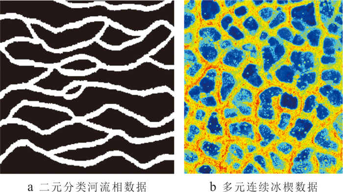
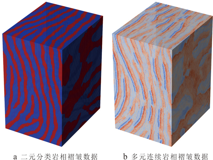
复杂地质结构建模在资源勘查、地下工程设计与地质灾害预测等领域具有重要意义. 生成对抗网络(GANs)在地质建模中展现出较强的非线性建模能力和模式迁移能力,但在处理复杂地质约束及精细结构重建时,其在建模精度、结构连通性及建模效率方面仍面临一些挑战. 针对上述问题,本文提出一种基于多尺度特征融合和深度可分离卷积的生成对抗网络地质建模方法,通过设计多尺度特征融合模块强化地质结构的细节表达与整体一致性,并引入深度可分离卷积以降低模型参数量和计算成本,提升建模效率. 同时,结合条件特征融合与渐进式分辨率生成策略,增强模型对条件数据的感知能力. 为验证方法的有效性,选取二维河流相、多属性冰楔和三维褶皱构造等典型数据,从空间变异性、连通性、属性一致性与条件点重建准确率等方面进行系统评估,并与多点统计方法(QS)和改进型生成对抗网络(CWGAN-GP)进行对比分析. 结果表明,在64×64和64×64×64的分辨率下,二维和三维四个数据集生成的模型MS-SWD指标分别为0.016、0.025和0.007 9、0.008 7,均显著低于对比方法;同时所生成模型的平均连通区域大小最接近参考模型(二维河流数据为300.59像素,三维褶皱数据为17 814.17像素);在整体准确度方面,本文方法的准确率和MSE指标均优于对比方法(分别为73.24%、69.48%和0.024、0.047),并通过效率分析和消融实验证明了该方法在效率和参数量方面的优势. 实验表明所提方法在保证合理与高保真性的同时,显著提升了建模效率,适用于复杂非平稳地质体的高效建模任务,具有广阔的工程应用前景.
Abstract:Complex geological structure modeling is of significant importance in fields such as resources exploration, underground engineering design, and geological hazard prediction. Generative Adversarial Networks (GANs) have demonstrated strong nonlinear modeling capabilities and pattern transfer abilities in geological modeling. However, when dealing with complex geological constraints and the reconstruction of fine structures, they still face challenges in modeling accuracy, structural connectivity, and modeling efficiency. To address these issues, this paper proposes a GAN-based geological modeling method incorporating multi-scale feature fusion and deep separable convolutions. A multi-scale feature fusion module enhances the expression of geological structure details and overall consistency, while deep separable convolutions reduce model parameters and computational costs, improving modeling efficiency. Additionally, a conditional feature adaptive fusion and progressive resolution generation strategy enhances the model's sensitivity to conditional data. To validate the method's effectiveness, typical models including two-dimensional river phases, multi-attribute ice wedges, and three-dimensional fold structures were selected. Systematic evaluations were conducted across spatial variability, connectivity, attribute consistency, and conditional point reconstruction accuracy. Comparative analyses were performed against multi-point statistical methods (e.g., QS) and an improved generative adversarial network (e.g., CWGAN-GP). The results show that at resolutions of 64×64 and 64×64×64, the MS-SWD indicators of the generated models for the two-dimensional and three-dimensional datasets are 0.016, 0.025, 0.007 9, and 0.008 7 respectively, which are significantly lower than those of the comparison methods. At the same time, the average connected region size of the generated models is closest to that of the reference model (300.59 pixels for the two-dimensional river data and 17 814.17 pixels for the three-dimensional fold data). In terms of overall accuracy, the accuracy rate and MSE indicators of the proposed method are superior to those of the comparison method (73.24%, 69.48% and 0.024, 0.047 respectively), and the advantages in efficiency and parameter quantity are proved through efficiency analysis and ablation experiments. The experiments show that the proposed method is suitable for efficient modeling tasks of complex non-stationary geological bodies since it significantly improves the modeling efficiency while ensuring reasonable and high fidelity, endowed with broad engineering application prospects.
-
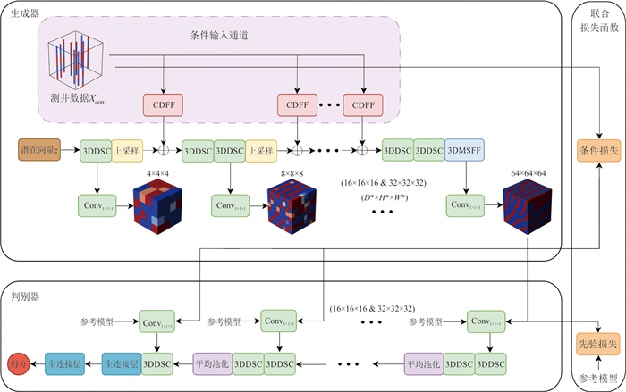
图 1 基于多尺度特征融合和深度可分离卷积的生成对抗网络地质建模方法总体框架设计
Fig. 1. Overall framework design of geological modeling method based on multi-scale features and depthwise separable convolution
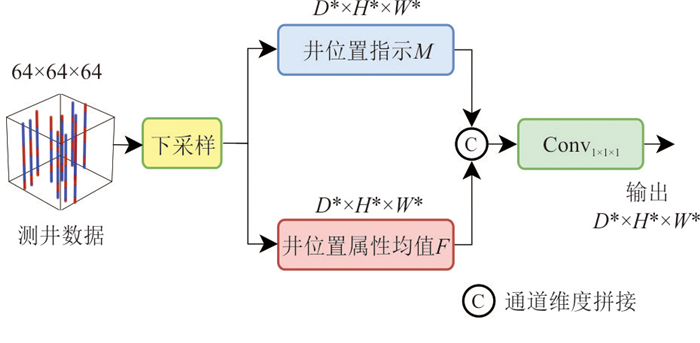
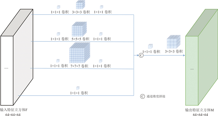
图 2 条件数据特征融合模块结构
Fig. 2. Structure diagram of the conditional data feature fusion module
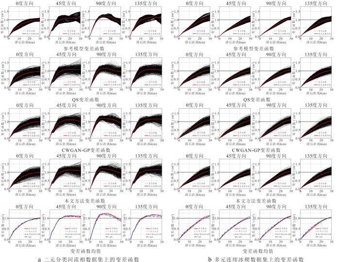
图 7 二维数据集上的变差函数及其均值对比图
Fig. 7. The contrast diagram of the variance function and its mean on the two-dimensional dataset
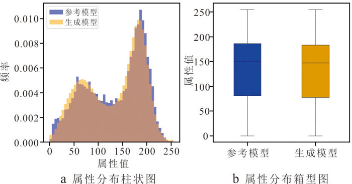
图 8 多元连续冰楔数据集的属性分布柱状图和箱型图
Fig. 8. Bar and box plots of attribute distributions for the multivariate continuous ice wedge dataset
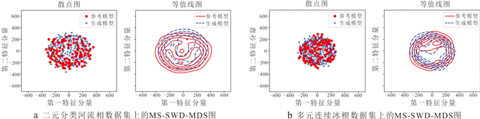
图 9 二维数据集生成结果和参考模型MS-SWD-MDS图
Fig. 9. The generation results of the two-dimensional dataset and the reference model MS-SWD-MDS graph
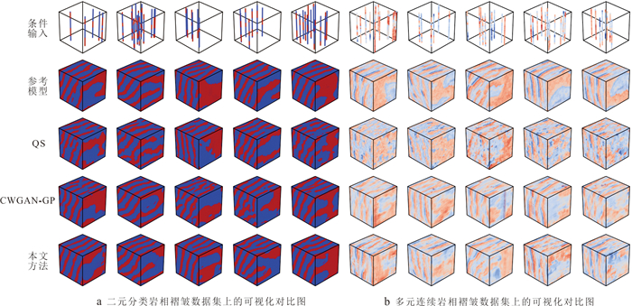
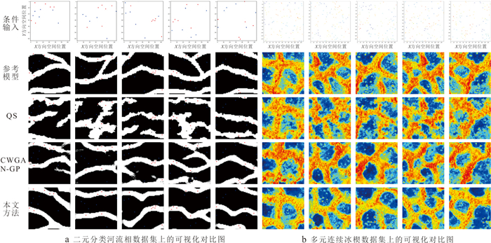
图 10 三维数据集上的可视化对比图
Fig. 10. Visualization comparison chart on three-dimensional dataset
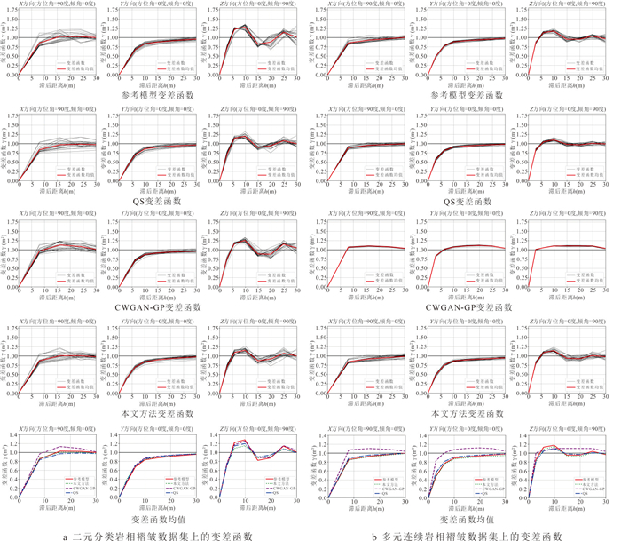
图 11 三维数据集上的变差函数及其均值对比
Fig. 11. The variogram and mean comparison graph of the three-dimensional dataset
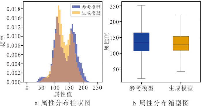
图 12 多元连续岩相褶皱数据集的属性分布柱状图(a)和箱型图(b)
Fig. 12. Histograms (a) and box plots (b) of attribute distribution in a multivariate continuous lithofacies fold dataset
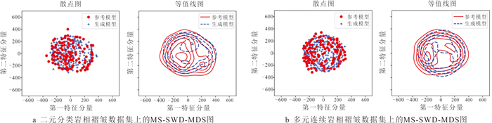
图 13 三维数据集生成结果和参考模型MS-SWD-MDS图
Fig. 13. The generation results of the three-dimensional dataset and the reference model MS-SWD-MDS graph
表 1 超参数设置
Table 1. Hyperparameter settings
超参数 训练数据 二维数据 三维数据 a b c d 4×4(×4)* 5 000 5 000 6 000 6 000 8×8(×8)* 10 000 12 000 15 000 15 000 16×16(×16)* 10 000 12 000 15 000 15 000 32×32(×32)* 10 000 12 000 15 000 15 000 64×64(×64)* 10 000 12 000 20 000 30 000 128×128(×128)* 无 12 000 无 无 批量大小 32 32 16 16 输入噪声维度 128 256 8 8 梯度惩罚权重($ {\lambda }_{\mathrm{g}\mathrm{p}} $) 10 10 10 10 条件损失权重($ {\lambda }_{\mathrm{c}\mathrm{o}\mathrm{n}} $) 500 500 500 500 学习率(生成器/判别器) 1×10‒4/1×10‒5 1×10‒4/1×10‒4 1×10‒3/1×10‒4 1×10‒3/1×10‒3 优化器 Adam 注:a为二元分类河流相数据集;b为多元连续冰楔数据集;c为二元分类岩相褶皱数据集;d为多元连续岩相褶皱数据集;*为分辨率等级.  下载: 导出CSV
表 2 不同权重下的生成结果
Table 2. Generation results under different weights
权重值 MS-SWD(64*)(10‒3) 二维数据 三维数据 a b c d λgp=5,λcon=400 23.15 35.96 8.05 8.91 λgp=5,λcon=500 19.42 29.34 7.99 10.53 λgp=5,λcon=600 21.27 31.62 8.11 9.14 λgp=10,λcon=400 18.25 29.37 7.96 11.06 λgp=10,λcon=600 21.16 26.78 8.03 9.72 λgp=10,λcon=500 16.13 24.76 7.92 8.66 注:a、b、c、d和*含义同表 1.
下载: 导出CSV
表 3 二元分类河流相数据集上的连通性指标
Table 3. Connectivity metrics on binary classification river facies dataset
连通区域(个) 平均连通区域大小(像素) 参考模型 1 229 475.58 QS 2 550 243.43 CWGAN-GP 2 950 195.22 本文方法 1 938 300.59
下载: 导出CSV
表 4 二维数据集上的MS-SWD指标和条件点准确率
Table 4. MS-SWD metric and condition point accuracy on the two-dimensional dataset
二元分类河流相数据集 多元连续冰楔数据集 MS-SWD (10‒3) 条件点准确率 MS‒SWD (10‒3) 条件点准确率 64* 32* 16* 64* 32* 16* QS 30.12 40.23 62.41 1 64.13 39.67 61.65 1 CWGAN-GP 25.29 33.48 63.32 0.97 55.21 33.28 25.22 0.97 本文方法 16.13 30.47 60.94 0.99 24.76 17.28 20.84 0.98 注:*代表不同的分辨率等级,加粗字体表示同组中的最优结果.
下载: 导出CSV
表 5 二元分类岩相褶皱数据集上的连通性指标
Table 5. Connectivity metrics on a binary classification lithofacies fold dataset
连通区域(个) 平均连通区域大小(像素) 参考模型 231 42 838.32 QS 1 490 6 742.76 CWGAN-GP 1 980 5 145.35 本文方法 556 17 814.17
下载: 导出CSV
表 6 三维数据集上的MS-SWD指标和条件点准确率
Table 6. The MS-SWD metric and conditional point accuracy on the 3D dataset
二元分类岩相褶皱数据集 多元连续岩相褶皱数据集 MS-SWD(10‒3) 条件点准确率 处理速度(ms/it) MS-SWD(10‒3) 条件点准确率 处理速度(ms/it) 64* 32* 16* 64* 32* 16* QS 12.57 20.49 35.34 1 7 000 20.59 27.28 28.77 1 7 000 CWGAN-GP 9.37 15.63 31.26 0.90 1.99 15.33 18.67 44.66 0.91 1.98 本文方法 7.92 14.13 29.21 0.99 1.65 8.66 9.51 17.55 0.99 1.66 注:*代表不同的分辨率等级,加粗字体表示同组中的最优结果,it代表iteration.
下载: 导出CSV
表 7 二元分类数据集上的整体准确度
Table 7. Overall accuracy on a binary classification dataset
二元分类河流相数据集准确率(%) 二元分类岩相褶皱数据集准确率(%) QS 65.38 61.41 CWGAN-GP 68.71 65.47 本文方法 73.24 69.48
下载: 导出CSV
表 8 多元连续数据集上的整体准确度
Table 8. Overall accuracy on multivariate continuous dataset
多元连续冰楔数据集(MSE) 多元连续岩相褶皱数据集(MSE) QS 0.033 0.066 CWGAN-GP 0.038 0.059 本文方法 0.024 0.047
下载: 导出CSV
表 9 不同分辨率阶段的标准卷积与深度可分离卷积训练效率对比
Table 9. Comparison of training efficiency between standard convolution and depthwise separable convolution at different resolution stages
数据集 卷积类型 分辨率 平均单epoch训练时间(s) 收敛轮数(epoch) GPU显存占用(GB) 总训练时间(h) 二元分类河流相数据集 标准卷积 4×4 1.136 3 892 3.2 1.58 8×8 1.194 6 975 4.5 3.32 16×16 1.382 6 451 6.8 3.84 32×32 1.526 7 253 9.2 4.24 64×64 1.717 7 792 12.5 4.77 深度可分离卷积 4×4 0.219 3 427 2.8 0.30 8×8 0.347 6 684 2.5 0.96 16×16 0.562 7 092 3.8 1.56 32×32 0.694 6 934 5.2 1.93 64×64 0.936 7 529 7.1 2.60 多元连续冰楔数据集 标准卷积 4×4 0.945 4 134 3.5 1.31 8×8 1.162 8 697 5.1 3.87 16×16 1.321 8 231 7.6 4.40 32×32 1.584 9 053 10.2 5.28 64×64 1.652 9 837 14.3 5.51 128×128 1.838 10 461 20.5 6.13 深度可分离卷积 4×4 0.416 4 074 2.1 0.58 8×8 0.543 8 453 3.2 1.81 16×16 0.694 9 879 4.5 2.31 32×32 0.829 8 125 6.3 2.76 64×64 0.987 8 396 8.7 3.29 128×128 1.125 9 837 12.4 3.75 二元分类岩相褶皱数据集 标准卷积 4×4×4 1.076 4 657 3.3 1.79 8×8×8 1.227 9 672 4.7 5.11 16×16×16 1.594 10 245 7.2 6.64 32×32×32 1.817 11 476 9.5 7.57 64×64×64 2.178 15 783 13.1 12.10 深度可分离卷积 4×4×4 0.347 5 247 1.9 0.58 8×8×8 0.424 9 782 2.7 1.77 16×16×16 0.754 10 347 4.1 3.14 32×32×32 1.189 9 978 5.5 4.95 64×64×64 1.515 12 267 7.8 8.42 多元连续岩相褶皱数据集 标准卷积 4×4×4 1.272 5 127 3.7 2.12 8×8×8 1.715 11 276 5.3 7.15 16×16×16 1.987 12 378 8.3 8.28 32×32×32 2.142 11 786 10.8 8.93 64×64×64 3.267 13 275 15.2 18.15 深度可分离卷积 4×4×4 0.594 4 937 2.3 0.99 8×8×8 0.772 9 834 3.4 3.22 16×16×16 1.171 10 276 4.8 4.88 32×32×32 1.481 12 176 6.7 6.17 64×64×64 1.490 12 976 9.2 12.42
下载: 导出CSV
表 10 不同组件的消融实验分析
Table 10. Ablation experimental analysis of different components
Baseline 3DMSFF 3DDSC MS-SWD(10‒3) 参数量(M) 浮点计算次数(G) 处理速度(ms/it) 64 32 16 √ 8.35 16.36 31.54 3.40 138.71 1.77 √ √ 7.81 14.28 28.79 5.58 711.82 21.68 √ √ √ 7.92 14.13 29.21 0.25 32.22 1.65
下载: 导出CSV
表 11 不同数据集下的不确定性量化指标
Table 11. Quantitative indicators of uncertainty under different dataset
MS-SWD (均值) MS-SWD (方差) 95%置信区间 P值 二维数据集 二元分类河流相数据集 0.048 4.1×10‒5 [0.045,0.051] 0.34 多元连续冰楔数据集 0.024 1.8×10‒5 [0.022,0.026] 0.47 三维数据集 二元分类岩相褶皱数据集 27.86 4.56 [26.86,28.86] 0.40 多元连续岩相褶皱数据集 15.14 1.64 [14.54,15.74] 0.51
下载: 导出CSV
-
Abedi, M., Norouzi, G. H., 2012. Integration of Various Geophysical Data with Geological and Geochemical Data to Determine Additional Drilling for Copper Exploration. Journal of Applied Geophysics, 83: 35-45. https://doi.org/10.1016/j.jappgeo.2012.05.003 Chan, S., Elsheikh, A. H., 2019. Parametric Generation of Conditional Geological Realizations Using Generative Neural Networks. Computational Geosciences, 23(5): 925-952. https://doi.org/10.1007/s10596-019-09850-7 Chen, Q. Y., Cui, Z. S., Liu, G., et al., 2022. Deep Convolutional Generative Adversarial Networks for Modeling Complex Hydrological Structures in Monte-Carlo Simulation. Journal of Hydrology, 610: 127970. https://doi.org/10.1016/j.jhydrol.2022.127970 Cui, Z. S., Chen, Q. Y., Liu, G., et al., 2024a. SA-RelayGANs: A Novel Framework for the Characterization of Complex Hydrological Structures Based on GANs and Self-Attention Mechanism. Water Resources Research, 60: e2023WR035932. https://doi.org/10.1029/2023wr035932 Cui, Z. S., Chen, Q. Y., Luo, J., et al., 2024b. Characterizing Subsurface Structures from Hard and Soft Data with Multiple-Condition Fusion Neural Network. Water Resources Research, 60(11): e2024WR038170. https://doi.org/10.1029/2024wr038170 Fan, W. Y., Liu, G., Chen, Q. Y., et al., 2023. Geological Model Automatic Reconstruction Based on Conditioning Wasserstein Generative Adversarial Network with Gradient Penalty. Earth Science Informatics, 16(3): 2825-2843. https://doi.org/10.1007/s12145-023-01012-9 Feng, R. H., Mosegaard, K., Grana, D., et al., 2024. Stochastic Facies Inversion with Prior Sampling by Conditional Generative Adversarial Networks Based on Training Image. Mathematical Geosciences, 56(4): 665-690. https://doi.org/10.1007/s11004-023-10119-0 Gravey, M., Mariethoz, G., 2020. QuickSampling V1.0: A Robust and Simplified Pixel-Based Multiple-Point Simulation Approach. Geoscientific Model Development, 13(6): 2611-2630. https://doi.org/10.5194/gmd-13-2611-2020 Heusel, M., Ramsauer, H., Unterthiner, T., et al., 2017. Gans Trained by a Two Time-Scale Update Rule Converge to a Local Nash Equilibrium. arXiv, 1706.08500. https://doi.org/10.48550/arXiv.1706.08500 Hou, W. S., Liu, H. G., Zheng, T. C., et al., 2022. Extended GOSIM: MPS-Driven Simulation of 3D Geological Structure Using 2D Cross-Sections. Earth and Space Science, 9(6): e2021EA001801. https://doi.org/10.1029/2021ea001801 Hu, F., Wu, C. L., Shang, J. W., et al., 2023. Multi-Condition Controlled Sedimentary Facies Modeling Based on Generative Adversarial Network. Computers & Geosciences, 171: 105290. https://doi.org/10.1016/j.cageo.2022.105290 Hu, X., Song, S. H., Hou, J. G., et al., 2024. Stochastic Modeling of Thin Mud Drapes Inside Point Bar Reservoirs with ALLUVSIM-GANSim. Water Resources Research, 60(6): e2023WR035989. https://doi.org/10.1029/2023wr035989 Hua, W. H., Zeng, X. L., Guo, D. Y., et al., 2024. 3D Geological Modeling Method Based on Tectonic Restoration Theory. Earth Science, 49(4): 1411-1420 (in Chinese with English abstract). Karras, T., Aila, T., Laine, S., et al., 2018. Progressive Growing of GANs for Improved Quality, Stability, and Variation. 6th International Conference on Learning Representations, ICLR 2018, Vancouver. Liu, G., Fang, H. F., Chen, Q. Y., et al., 2022. A Feature-Enhanced MPS Approach to Reconstruct 3D Deposit Models Using 2D Geological Cross Sections: A Case Study in the Luodang Cu Deposit, Southwestern China. Natural Resources Research, 31(6): 3101-3120. https://doi.org/10.1007/s11053-022-10113-z Marano, G. C., Rosso, M. M., Aloisio, A., et al., 2024. Generative Adversarial Networks Review in Earthquake-Related Engineering Fields. Bulletin of Earthquake Engineering, 22(7): 3511-3562. https://doi.org/10.1007/s10518-023-01645-7 Mariethoz, G., Renard, P., Straubhaar, J., 2010. The Direct Sampling Method to Perform Multiple-Point Geostatistical Simulations. Water Resources Research, 46(11): 2008WR007621. https://doi.org/10.1029/2008wr007621 Mohaghegh, S. D., 2013. Reservoir Modeling of Shale Formations. Journal of Natural Gas Science and Engineering, 12: 22-33. https://doi.org/10.1016/j.jngse.2013.01.003 Mosser, L., Dubrule, O., Blunt, M. J., 2020. Stochastic Seismic Waveform Inversion Using Generative Adversarial Networks as a Geological Prior. Mathematical Geosciences, 52(1): 53-79. https://doi.org/10.1007/s11004-019-09832-6 Mustapha, H., Dimitrakopoulos, R., 2011. HOSIM: A High-Order Stochastic Simulation Algorithm for Generating Three-Dimensional Complex Geological Patterns. Computers & Geosciences, 37(9): 1242-1253. https://doi.org/10.1016/j.cageo.2010.09.007 Song, S. H., Mukerji, T., Hou, J. G., 2021. GANSim: Conditional Facies Simulation Using an Improved Progressive Growing of Generative Adversarial Networks (GANs). Mathematical Geosciences, 53(7): 1413-1444. https://doi.org/10.1007/s11004-021-09934-0 Song, S. H., Shi, Y. Q., Hou, J. G., 2022. Review of a Generative Adversarial Networks(GANs)-Based Geomodelling Method. Petroleum Science Bulletin, 7(1): 34-49 (in Chinese with English abstract). Strebelle, S., 2002. Conditional Simulation of Complex Geological Structures Using Multiple-Point Statistics. Mathematical Geology, 34(1): 1-21. https://doi.org/10.1023/A:1014009426274 Tang, J. F., Tang, M. M., Lu, S. F., et al., 2024. Three-Dimensional Modeling of Estuary Reservoir Based on Coupling Sedimentary Dynamics Simulation and Multipoint Geostatistics Method. Earth Science, 49(1): 174-188 (in Chinese with English abstract). Wang, G. C., Xu, Y. X., Chen, X. J., et al., 2015. Three-Dimensional Geological Mapping and Visualization of Complex Orogenic Belts. Earth Science, 40(3): 397-406 (in Chinese with English abstract). Wang, L. F., Liu, X. L., Xu, K., et al., 2024. Bayesian-MCMC (Markov Chain Monte Carlo) Based Three-Dimensional Geological Model Optimization by Data and Knowledge Fusion. Earth Science, 49(8): 3056-3070 (in Chinese with English abstract). Zhang, T. F., Tilke, P., Dupont, E., et al., 2019. Generating Geologically Realistic 3D Reservoir Facies Models Using Deep Learning of Sedimentary Architecture with Generative Adversarial Networks. Petroleum Science, 16(3): 541-549. https://doi.org/10.1007/s12182-019-0328-4 Zhang, T., Yang, Z. H., Li, D. Y., 2022. Stochastic Simulation of Deltas Based on a Concurrent Multi-Stage VAE-GAN Model. Journal of Hydrology, 607: 127493. https://doi.org/10.1016/j.jhydrol.2022.127493 Zhou, T., Li, Q., Lu, H. L., et al., 2023. GAN Review: Models and Medical Image Fusion Applications. Information Fusion, 91: 134-148. https://doi.org/10.1016/j.inffus.2022.10.017 花卫华, 曾新灵, 郭丹阳, 等, 2024. 基于构造恢复理论的含复杂断层三维地质建模方法. 地球科学, 49(4): 1411-1420. doi: 10.3799/dqkx.2022.452 宋随宏, 史燕青, 侯加根, 2022. 基于生成对抗网络的储层地质建模方法研究进展. 石油科学通报, 7(1): 34-49. 唐佳凡, 唐明明, 卢双舫, 等, 2024. 基于耦合沉积动力学模拟与多点地质统计学方法的河口湾储层三维建模. 地球科学, 49(1): 174-188. doi: 10.3799/dqkx.2022.199 王国灿, 徐义贤, 陈旭军, 等, 2015. 基于地表地质调查剖面网络基础上的复杂造山带三维地质调查与建模方法. 地球科学, 40(3): 397-406. doi: 10.3799/dqkx.2015.031 王丽芳, 刘肖莉, 徐坤, 等, 2024. 数据和知识融合的Bayesian-MCMC三维地质建模. 地球科学, 49(8): 3056-3070. doi: 10.3799/dqkx.2023.069 -

 点击查看大图
计量
- 文章访问数: 160
- HTML全文浏览量: 25
- PDF下载量: 44
- 被引次数: 0
