2012 Vol. 37, No. 6
Display Method:
 PDF 513KB
2012, 37(6): 1109-1125.
doi: 10.3799/dqkx.2012.118
Abstract:
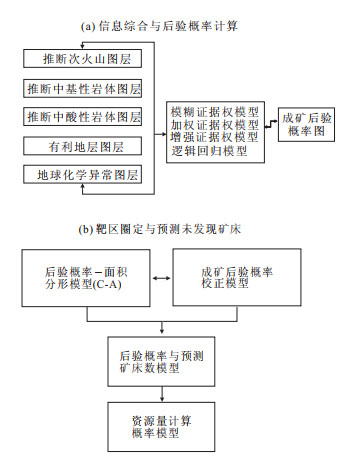
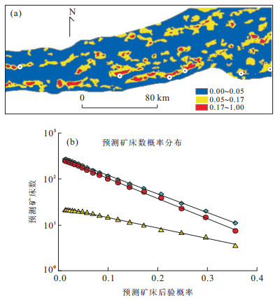
In this paper, it is shown that the element concentration in the stream sediments in the covered areas can be very low due to decay and mask effects even if a thin layer of overburden exists. The examples introduced in the paper for prediction of mineral deposits of skarn types have demonstrated that the nonlinear singularity and generalized self-similarity theories and methods can be used to map anomalies for locating undiscovered mineral deposits in areas covered by transported regolith. Three main aspects of difficulties facing mineral exploration and mineral deposit prediction in covered areas are discussed in the paper which include weak anomalies detection and recognition, decomposition of complex and mixing anomalies due to multiple geo-processes, and application of evidential layers with missing or incomplete information due to covers. Various models have been proposed for prediction of various objects including felsic intrusions, skarn and hydrothermal alterations and local geochemical anomalies. Several datasets, including 1∶200 000 scale geological maps, stream sediment geochemical data, aeromagnetic and gravity data were applied for delineation of potential target areas for Fe mineral deposits of volcanic skarn and hydrothermal types in the areas covered by desert and Ternary to Quaternary sediments.
In this paper, it is shown that the element concentration in the stream sediments in the covered areas can be very low due to decay and mask effects even if a thin layer of overburden exists. The examples introduced in the paper for prediction of mineral deposits of skarn types have demonstrated that the nonlinear singularity and generalized self-similarity theories and methods can be used to map anomalies for locating undiscovered mineral deposits in areas covered by transported regolith. Three main aspects of difficulties facing mineral exploration and mineral deposit prediction in covered areas are discussed in the paper which include weak anomalies detection and recognition, decomposition of complex and mixing anomalies due to multiple geo-processes, and application of evidential layers with missing or incomplete information due to covers. Various models have been proposed for prediction of various objects including felsic intrusions, skarn and hydrothermal alterations and local geochemical anomalies. Several datasets, including 1∶200 000 scale geological maps, stream sediment geochemical data, aeromagnetic and gravity data were applied for delineation of potential target areas for Fe mineral deposits of volcanic skarn and hydrothermal types in the areas covered by desert and Ternary to Quaternary sediments.

2012, 37(6): 1126-1132.
doi: 10.3799/dqkx.2012.119
Abstract:
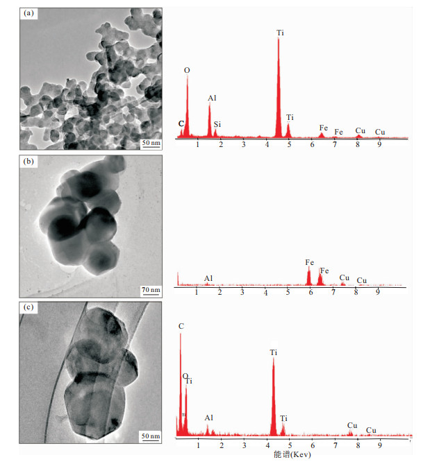
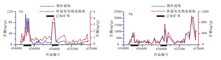
Recent years, a great progress on exploration geochemistry has been made in findings of evidences of nanoparticles of metals and metals in vegetable cells. The findings have provided nanoscale and molecular-level understanding of metal transportation from the concealed ore bodies through the overburden covers. The case history studies from concealed Au, Cu-Ni, Cu-Au-Ag deposits show that these nanoparticles of metals could penetrate through sedimentary, metamorphic and soil covers to the surface. Nanoparticle sampling and selective leaching of oxide coatings are effective to indicate concealed deposits. Case study on sandstone-type uranium deposits show that uranium is converted to uranyl ions (UO22+) under oxidizing conditions and is sorbed on clay minerals to accumulate in anomalous concentrations, which comprise from 17.9% to 40% of the total U content. Separation of fine-grained clay-rich soils or selective leaching of absorbed U onto clays are effective for deep-penetrating geochemical surveys for sandstone-type uranium deposits.
Recent years, a great progress on exploration geochemistry has been made in findings of evidences of nanoparticles of metals and metals in vegetable cells. The findings have provided nanoscale and molecular-level understanding of metal transportation from the concealed ore bodies through the overburden covers. The case history studies from concealed Au, Cu-Ni, Cu-Au-Ag deposits show that these nanoparticles of metals could penetrate through sedimentary, metamorphic and soil covers to the surface. Nanoparticle sampling and selective leaching of oxide coatings are effective to indicate concealed deposits. Case study on sandstone-type uranium deposits show that uranium is converted to uranyl ions (UO22+) under oxidizing conditions and is sorbed on clay minerals to accumulate in anomalous concentrations, which comprise from 17.9% to 40% of the total U content. Separation of fine-grained clay-rich soils or selective leaching of absorbed U onto clays are effective for deep-penetrating geochemical surveys for sandstone-type uranium deposits.
2012, 37(6): 1133-1139.
doi: 10.3799/dqkx.2012.120
Abstract:
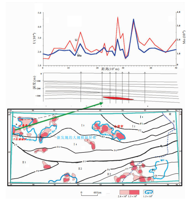
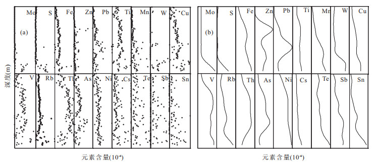
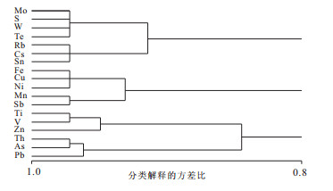
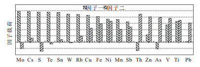
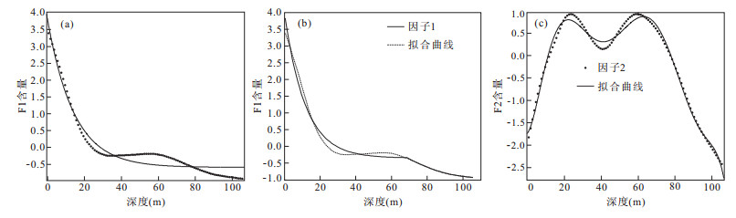
106 samples were sequentially collected from a 106.5 m vertical core of the loess cover on the Diyanqinamu Mo-Ag deposit in the grassland area in the Inner Mongolia. The contents of 33 elements were measured by Niton XL3t X-ray fluorescence analyzer. After the normality test, the correlation between the contents of elements and the depth were analyzed by Kendall τ correlation coefficient method, which shows that the contents of 18 elements Mo, S, W, Te, Fe, Cu, Ni, Mn, Sb, Rb, Cs, Sn, Zn, Ti, V, Pb, Th and As from the loess cover are statistically correlated with the distances from the ore source. The long-term trends of the 18 elements were detached from the content spatial series, which were classified into several clusters. Ore-forming factors Mo-W factor and Pb-Zn factor were obtained by factor analysis, and the exponent transportation modes of the Mo-W factor were simulated. The research approach and results of this paper could be useful references for evaluating mineral resources of covered areas from the surface geochemical anomalies.
106 samples were sequentially collected from a 106.5 m vertical core of the loess cover on the Diyanqinamu Mo-Ag deposit in the grassland area in the Inner Mongolia. The contents of 33 elements were measured by Niton XL3t X-ray fluorescence analyzer. After the normality test, the correlation between the contents of elements and the depth were analyzed by Kendall τ correlation coefficient method, which shows that the contents of 18 elements Mo, S, W, Te, Fe, Cu, Ni, Mn, Sb, Rb, Cs, Sn, Zn, Ti, V, Pb, Th and As from the loess cover are statistically correlated with the distances from the ore source. The long-term trends of the 18 elements were detached from the content spatial series, which were classified into several clusters. Ore-forming factors Mo-W factor and Pb-Zn factor were obtained by factor analysis, and the exponent transportation modes of the Mo-W factor were simulated. The research approach and results of this paper could be useful references for evaluating mineral resources of covered areas from the surface geochemical anomalies.
2012, 37(6): 1140-1148.
doi: 10.3799/dqkx.2012.121
Abstract:
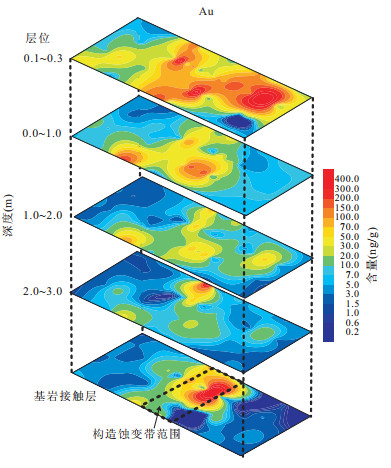
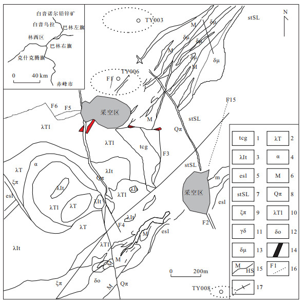
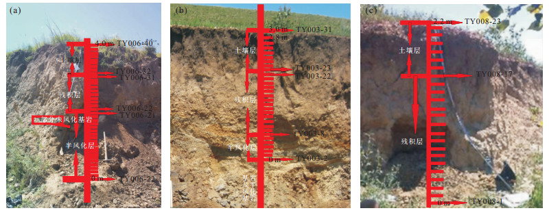
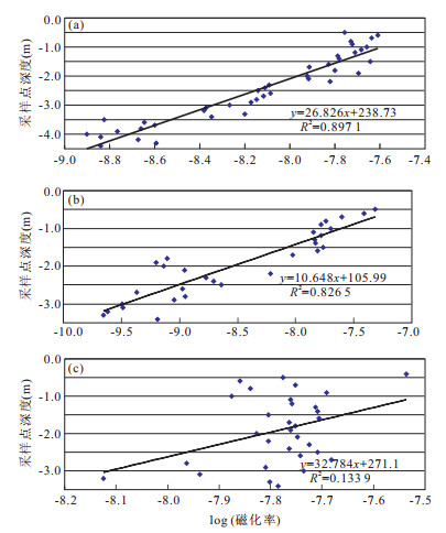
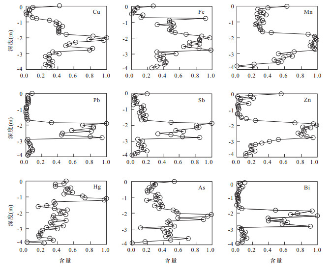
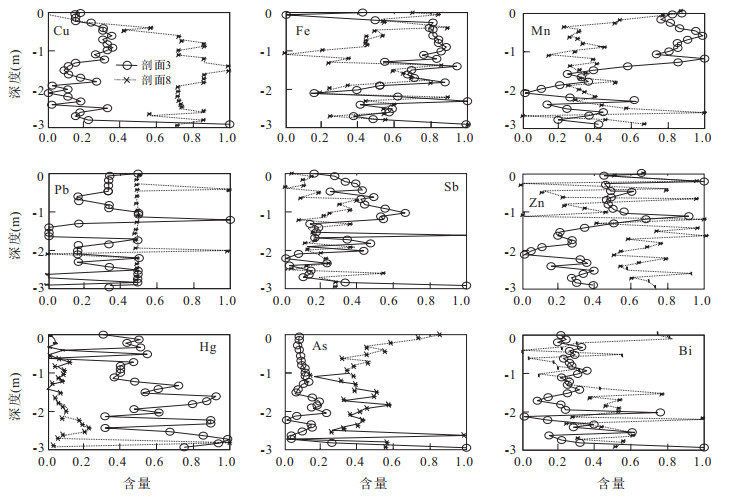
Geochemical soil survey is of great significance to find the geochemical soil anomalies related to ore deposits. Baiyinnuoer lead-zinc deposit in Inner Mongolia is one typical Skarn deposit in North China and detailed geological mining survey had been done in this area to prospect ore-bodies. In this study, 3 typical vertical soil profiles had been sampled to study the geochemical vertical transportation modes and then to further explore new ideas for mineral resource prospecting. Soil profile 6 was collected upon one Pb-Zn ore-body. Profile 3 and Profile 8 were 1 km and 4.5 km away from Profile 6, respectively. Along Profile 6 and Profile 3, soil magnetic susceptibility values decrease significantly with the depth of the soil samples increasing. The distribution patterns of all the 9 geochemical elements along Profile 6 display a similar trend which shows the concentrations are lower in both topsoil layer and half-weathered rock layer, but higher in residual subsoil layer, showing as "C-shape", which are quite different from those patterns for profile 3 and profile 8, since the element concentration values do fluctuate violently without a similar trend as shown in Profile 6. The research approach and results of this paper could be useful references for evaluating mineral resources in covered areas from the surface geochemical soil surveys and it also could provide new avenues for detecting the geochemical mechanisms for vertical transportation.
Geochemical soil survey is of great significance to find the geochemical soil anomalies related to ore deposits. Baiyinnuoer lead-zinc deposit in Inner Mongolia is one typical Skarn deposit in North China and detailed geological mining survey had been done in this area to prospect ore-bodies. In this study, 3 typical vertical soil profiles had been sampled to study the geochemical vertical transportation modes and then to further explore new ideas for mineral resource prospecting. Soil profile 6 was collected upon one Pb-Zn ore-body. Profile 3 and Profile 8 were 1 km and 4.5 km away from Profile 6, respectively. Along Profile 6 and Profile 3, soil magnetic susceptibility values decrease significantly with the depth of the soil samples increasing. The distribution patterns of all the 9 geochemical elements along Profile 6 display a similar trend which shows the concentrations are lower in both topsoil layer and half-weathered rock layer, but higher in residual subsoil layer, showing as "C-shape", which are quite different from those patterns for profile 3 and profile 8, since the element concentration values do fluctuate violently without a similar trend as shown in Profile 6. The research approach and results of this paper could be useful references for evaluating mineral resources in covered areas from the surface geochemical soil surveys and it also could provide new avenues for detecting the geochemical mechanisms for vertical transportation.
2012, 37(6): 1149-1159.
doi: 10.3799/dqkx.2012.122
Abstract:
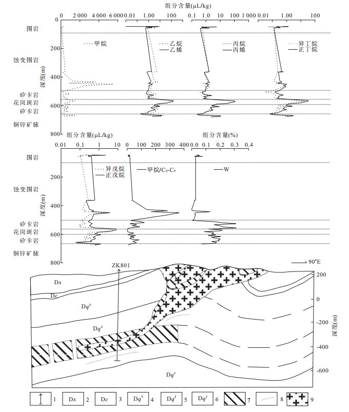
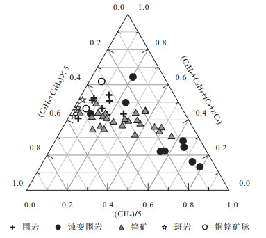
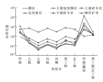
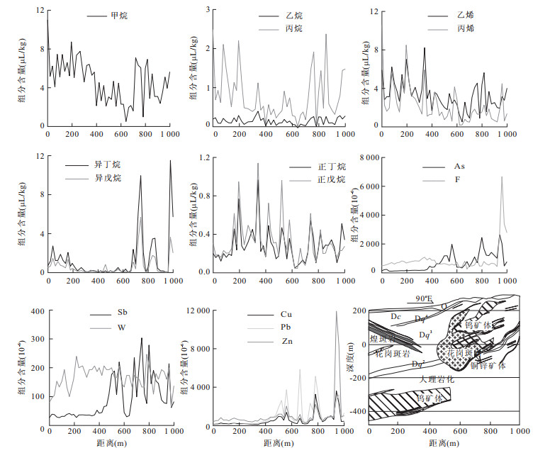
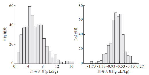
Weijia tungsten ore is located at Xiang Linpu Town, Hunan Province. It is in the Xiang Linpu porphyry groups near the Tong Shanling porphyry. The large skarn type deposit was detected using comprehensive exploration method during the recent exploration activities in China. Being buried deeply in 500 m and covered by limestone and thick soil in the surface, it has hardly been indicated by traditional pathfinder elements. It is proved that hydrocarbons promoted the transport and enrichment of elements in the ore forming, so Weijia tungsten ore is taken as a case to study the effect of hydrocarbons to the concealed deposits in coverage area. Acidolysis hydrocarbon of 46 rock samples in ZK801 and heat release hydrocarbon of 3 soil profiles were analyzed. The results show that the contents of hydrocarbons decrease from porphyry, ore body to wall rock, and the rates of methane, olefins and heavy alkane are different in porphyry, ore body and wall rock. The standard curves shapes of ore are similar to those of the porphyry and wall rock. The soil heat release hydrocarbons show bimodal distribution and low value above the ore body. This study proves that the hydrocarbons are more useful to indicate the concealed mine than the traditional pathfinder elements.
Weijia tungsten ore is located at Xiang Linpu Town, Hunan Province. It is in the Xiang Linpu porphyry groups near the Tong Shanling porphyry. The large skarn type deposit was detected using comprehensive exploration method during the recent exploration activities in China. Being buried deeply in 500 m and covered by limestone and thick soil in the surface, it has hardly been indicated by traditional pathfinder elements. It is proved that hydrocarbons promoted the transport and enrichment of elements in the ore forming, so Weijia tungsten ore is taken as a case to study the effect of hydrocarbons to the concealed deposits in coverage area. Acidolysis hydrocarbon of 46 rock samples in ZK801 and heat release hydrocarbon of 3 soil profiles were analyzed. The results show that the contents of hydrocarbons decrease from porphyry, ore body to wall rock, and the rates of methane, olefins and heavy alkane are different in porphyry, ore body and wall rock. The standard curves shapes of ore are similar to those of the porphyry and wall rock. The soil heat release hydrocarbons show bimodal distribution and low value above the ore body. This study proves that the hydrocarbons are more useful to indicate the concealed mine than the traditional pathfinder elements.
2012, 37(6): 1160-1168.
doi: 10.3799/dqkx.2012.123
Abstract:
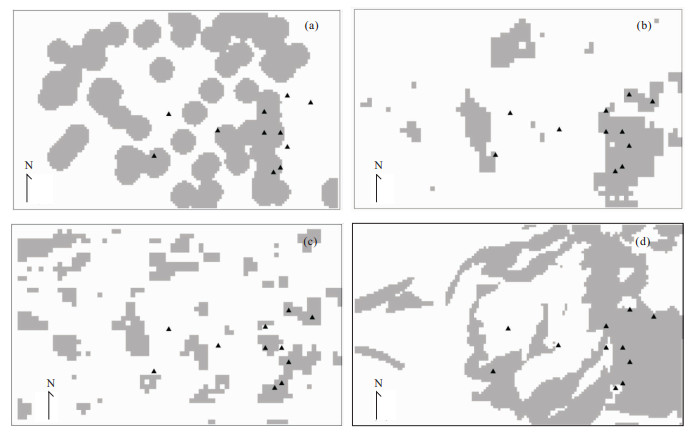
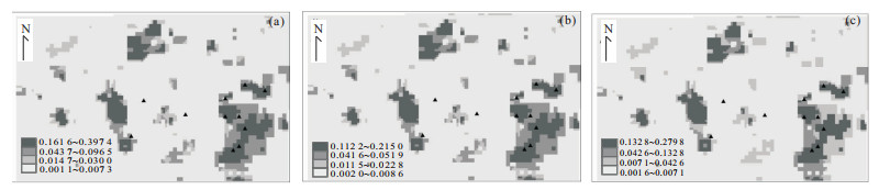
Weights of evidence (WofE) is one of the most widely used methods in prediction and evaluation of mineral resources. It requires the independence of geological variables. However, it is almost impossible to meet the requirement among geological variables. The study of reducing the influence of the independence of variables has become a hot topic. One way to solve the problem is to modify the traditional WofE model such as modifying the weights of each evidential layer by calculating correction factor. In this study, some weighted WofE models proposed in recent years are systematically studied, i.e., the same data of case and the same test program are used to compare these models. The results illustrate that weighted WofE models can reduce the influence of dependence among variables to some extent, and the weighted WofE model based on logistic regression performs better than others.
Weights of evidence (WofE) is one of the most widely used methods in prediction and evaluation of mineral resources. It requires the independence of geological variables. However, it is almost impossible to meet the requirement among geological variables. The study of reducing the influence of the independence of variables has become a hot topic. One way to solve the problem is to modify the traditional WofE model such as modifying the weights of each evidential layer by calculating correction factor. In this study, some weighted WofE models proposed in recent years are systematically studied, i.e., the same data of case and the same test program are used to compare these models. The results illustrate that weighted WofE models can reduce the influence of dependence among variables to some extent, and the weighted WofE model based on logistic regression performs better than others.
2012, 37(6): 1169-1174.
doi: 10.3799/dqkx.2012.124
Abstract:
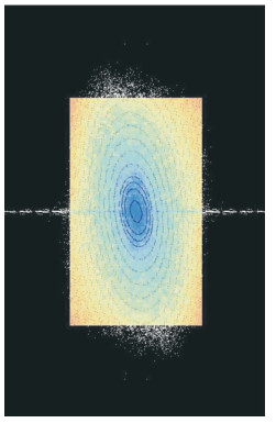
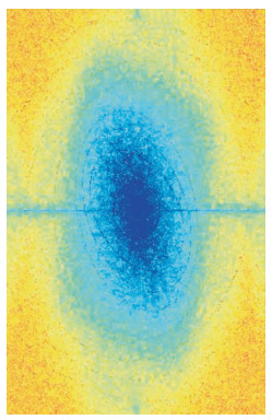
Mixing fields caused by processes and effects with different scales are very common in geosciences researches. It is important to work out methods to quantify anisotropic scale invariance for these fields. This paper puts forward a newly developed anisotropic scale invariance quantification and mixing data decomposition method for images and applies it to remote sensing image processing, which is an integrated model of the SIG (scale invariant generator) model and S-A (spectrum-area) model. For any 2D fields, S-A model is used to identify if it is a mixing field. If it is, decompose it into different components also by S-A. Then use SIG model to quantify the decomposed components' anisotropic scale invariance and describe their transformation characteristics. An application of processing a mixing remote sensing image demonstrates that this method is able to quantify anisotropic scale invariance for 2D mixing fields and mixing fields must be decomposed properly before application.
Mixing fields caused by processes and effects with different scales are very common in geosciences researches. It is important to work out methods to quantify anisotropic scale invariance for these fields. This paper puts forward a newly developed anisotropic scale invariance quantification and mixing data decomposition method for images and applies it to remote sensing image processing, which is an integrated model of the SIG (scale invariant generator) model and S-A (spectrum-area) model. For any 2D fields, S-A model is used to identify if it is a mixing field. If it is, decompose it into different components also by S-A. Then use SIG model to quantify the decomposed components' anisotropic scale invariance and describe their transformation characteristics. An application of processing a mixing remote sensing image demonstrates that this method is able to quantify anisotropic scale invariance for 2D mixing fields and mixing fields must be decomposed properly before application.


2012, 37(6): 1175-1182.
doi: 10.3799/dqkx.2012.125
Abstract:
This paper proposes a new method to estimate weighting coefficients in weighted weights of evidence (WWofE) in order to reduce the influence of correlation among evidence layers when hypothesis of conditional independence is not true. Sequential estimation method in WWofE combines WWofE and dual weights of evidence (DWofE) to gradually add evidence layers with specific sequence to WWofE model. In the process, the posterior probability obtained by former evidence layers is considered as fuzzy training layer in DWofE to correct the sequence of layers. The weighting coefficients are estimated by using conditional correlation coefficient. As a case study, a group data generated by four variable normal distribution and Sn-Cu mineral resources assessment in Gejiu, Yunan, southwestern China are used. The results show that WWofE model is effective to reduce the influence of correlations among evidence layers.
This paper proposes a new method to estimate weighting coefficients in weighted weights of evidence (WWofE) in order to reduce the influence of correlation among evidence layers when hypothesis of conditional independence is not true. Sequential estimation method in WWofE combines WWofE and dual weights of evidence (DWofE) to gradually add evidence layers with specific sequence to WWofE model. In the process, the posterior probability obtained by former evidence layers is considered as fuzzy training layer in DWofE to correct the sequence of layers. The weighting coefficients are estimated by using conditional correlation coefficient. As a case study, a group data generated by four variable normal distribution and Sn-Cu mineral resources assessment in Gejiu, Yunan, southwestern China are used. The results show that WWofE model is effective to reduce the influence of correlations among evidence layers.
2012, 37(6): 1183-1190.
doi: 10.3799/dqkx.2012.126
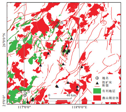
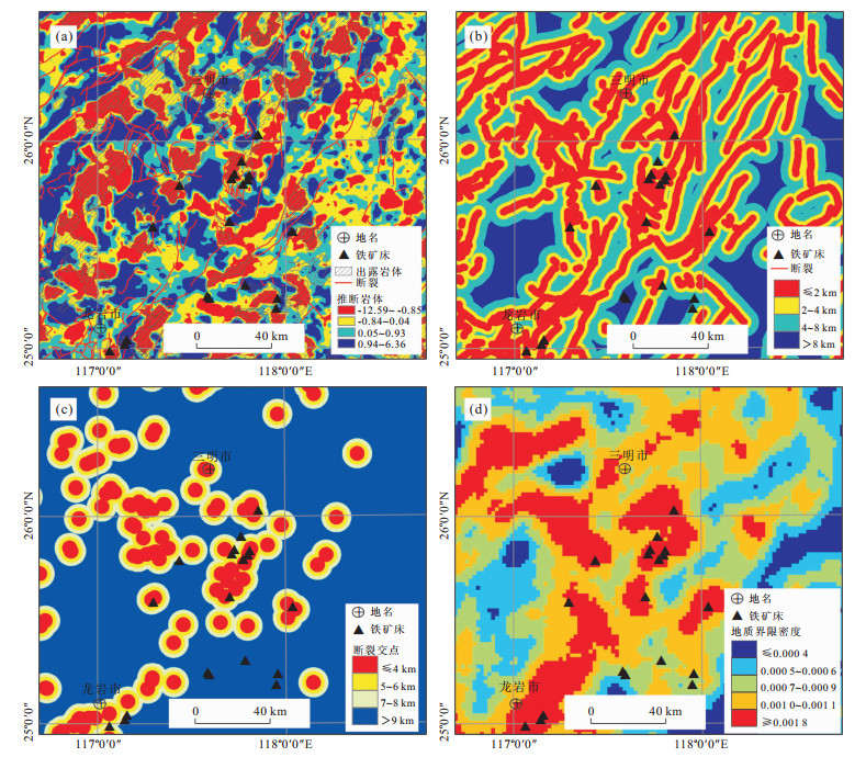
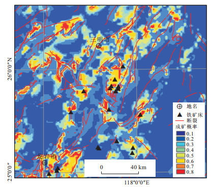
Abstract:
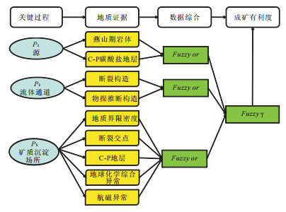
Study of geological processes including: (1) establishment of energy gradients to drive the system, (2) generation of hydrothermal fluids, (3)extraction of metals and chemical ligands for metal complexation from suitable sources, (4) transportation of metals from sources regions to trap zones, (5)deposition of metals triggered by chemical and physical processes that alter the make-up of melts or fluids migrating through trap zones, and (6) preservation of mineral deposits through time is the basis for mineral resource quantitative prediction and assessment (MRQPA) since the forming and preservation of mineral deposits is a spatial-temporal function of geological processes. In this study, geological process-based mineral resource quantitative prediction and assessment for Makeng type iron polymetallic deposits in Fujian Province is implemented. The focuses are to study the critical geological processes and evidences that these processes have occurred, and to evaluate the probability of occurrences of the critical geological processes. This study offers a new prospective for mineral resource exploration, and provides a new strategy for further Makeng type iron polymetallic mineral exploration in Fujian province.
Study of geological processes including: (1) establishment of energy gradients to drive the system, (2) generation of hydrothermal fluids, (3)extraction of metals and chemical ligands for metal complexation from suitable sources, (4) transportation of metals from sources regions to trap zones, (5)deposition of metals triggered by chemical and physical processes that alter the make-up of melts or fluids migrating through trap zones, and (6) preservation of mineral deposits through time is the basis for mineral resource quantitative prediction and assessment (MRQPA) since the forming and preservation of mineral deposits is a spatial-temporal function of geological processes. In this study, geological process-based mineral resource quantitative prediction and assessment for Makeng type iron polymetallic deposits in Fujian Province is implemented. The focuses are to study the critical geological processes and evidences that these processes have occurred, and to evaluate the probability of occurrences of the critical geological processes. This study offers a new prospective for mineral resource exploration, and provides a new strategy for further Makeng type iron polymetallic mineral exploration in Fujian province.
2012, 37(6): 1191-1198.
doi: 10.3799/dqkx.2012.127
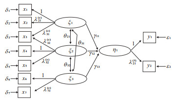
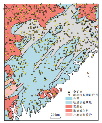
Abstract:
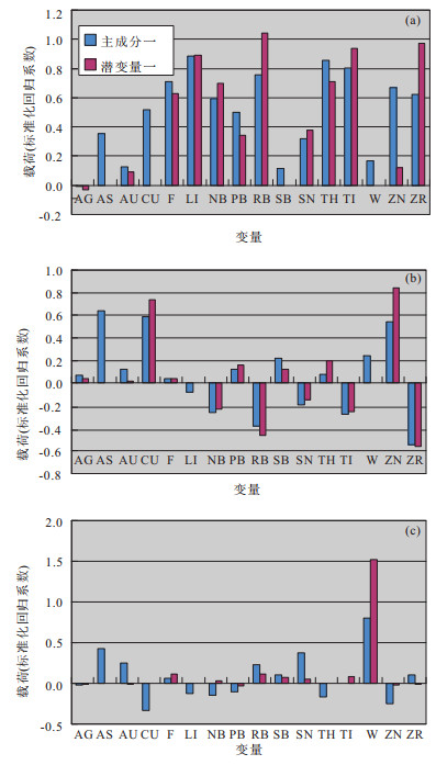
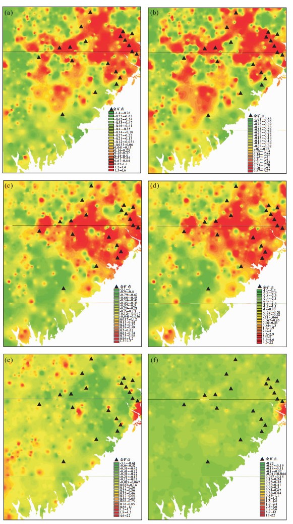
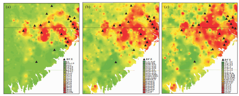
In order to find a combination of geochemical elements reflecting the abnormal mineralization, this paper provides a method of structural equation modeling (SEM) for geochemical data processing based on principal component analysis (PCA). Different from the PCA, the structural equation model takes the favorable fitness with studying object as the criterion to determine the optimal solution, through which the new component will be determined; it is a combination of factor analysis and path analysis. Therefore, the component determined by the structural model is not necessarily the one with the largest variability, but the one closest to the object of study, which can thus better reflect the research target. This study not only describes the principle of structural equation modeling, but also makes use of it in the geochemical data analysis experiment. The geochemical data is measured from lake sediments samples obtained from the Southwest Nova Scotia, Canada, a model of geochemical elements related to the hydrothermal fluid gold mine is established. The spatial distribution law of the composite variables given by the structural model, and the relation between those variables and the gold deposits as well, is studied. A comparison with those of the PCA results shows that the factor variables related to the gold mine computed by the structural equation modeling are highly correlated to the space of the gold deposits, and they can also better predict the gold deposits.
In order to find a combination of geochemical elements reflecting the abnormal mineralization, this paper provides a method of structural equation modeling (SEM) for geochemical data processing based on principal component analysis (PCA). Different from the PCA, the structural equation model takes the favorable fitness with studying object as the criterion to determine the optimal solution, through which the new component will be determined; it is a combination of factor analysis and path analysis. Therefore, the component determined by the structural model is not necessarily the one with the largest variability, but the one closest to the object of study, which can thus better reflect the research target. This study not only describes the principle of structural equation modeling, but also makes use of it in the geochemical data analysis experiment. The geochemical data is measured from lake sediments samples obtained from the Southwest Nova Scotia, Canada, a model of geochemical elements related to the hydrothermal fluid gold mine is established. The spatial distribution law of the composite variables given by the structural model, and the relation between those variables and the gold deposits as well, is studied. A comparison with those of the PCA results shows that the factor variables related to the gold mine computed by the structural equation modeling are highly correlated to the space of the gold deposits, and they can also better predict the gold deposits.
2012, 37(6): 1199-1208.
doi: 10.3799/dqkx.2012.128
Abstract:
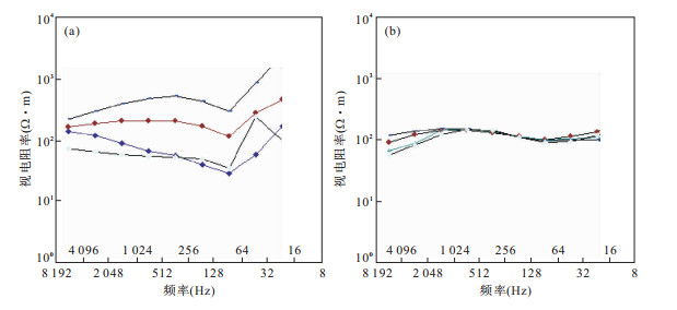
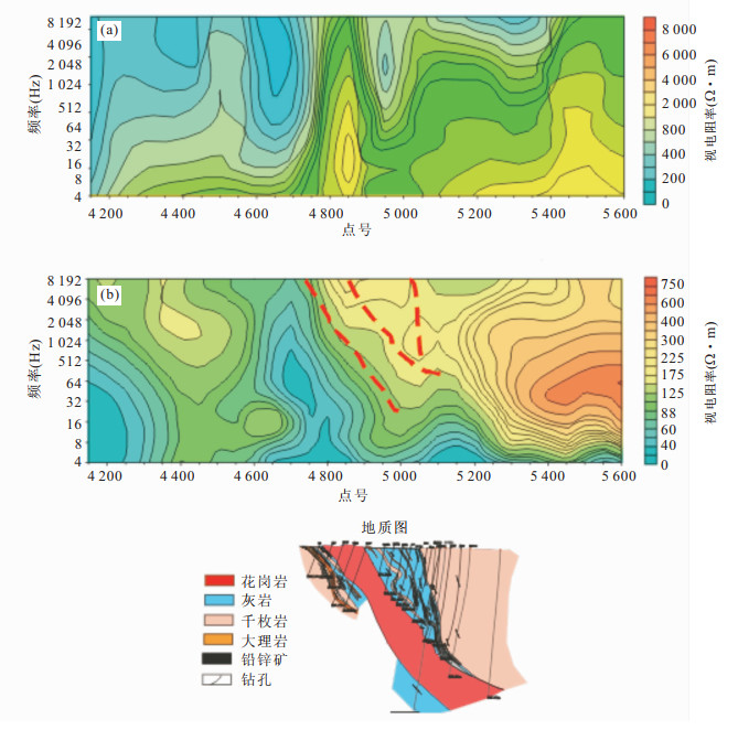
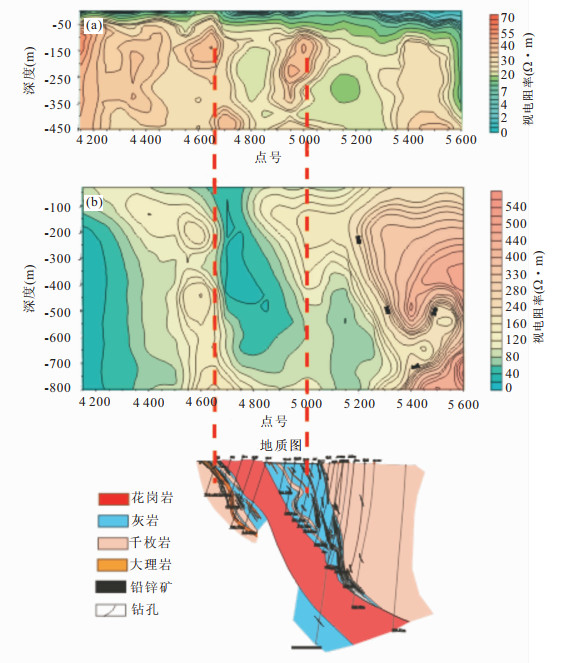
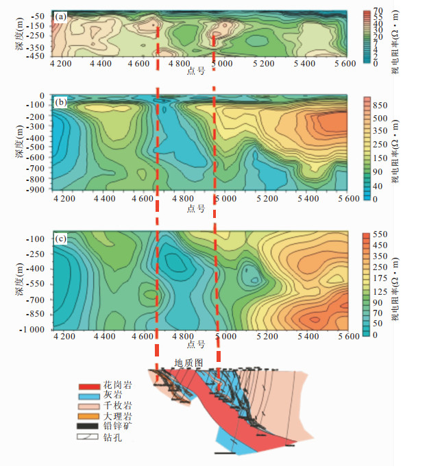
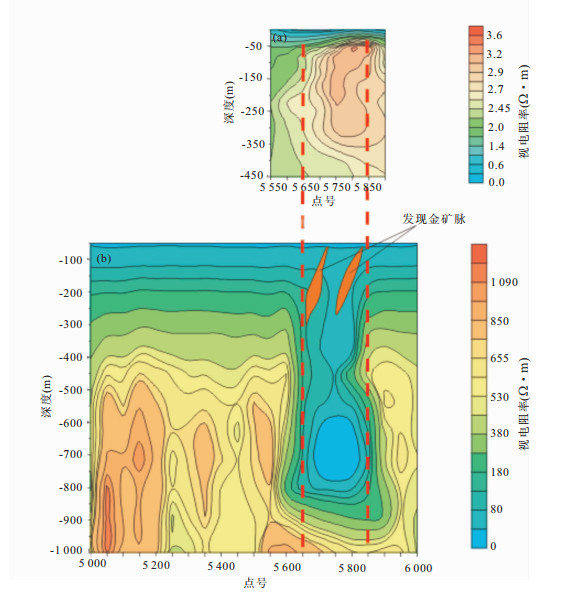
The geophysical anomalies are very weak in mineral prospecting of the areas with thick covering layer, especially in the second exploration of crisis mines where the cultural disturbances are strong, which makes it more difficult for ore prospecting. In order to carry out the explorations for hidden ore deposits in coverage areas, we adopt three methods with artificial source, namely, transient electromagnetic method (TEM), controlled source audio-frequency magnetotelluric (CSAMT) and induced polarization (IP) respectively, whose signals are strong enough for prospecting in the working areas. In addition, we have analyzed the advantages of the combination of these three methods in theory. It is found that the three methods can not only complement with one another in depth but also correct one another in interpretation. The electrical joint interpretation method has achieved a satisfying result in metal prospecting in Gansu Province, where these three methods complement and validate each other well. Therefore, the electrical joint interpretation method provides an effective way for mineral exploration in coverage areas.
The geophysical anomalies are very weak in mineral prospecting of the areas with thick covering layer, especially in the second exploration of crisis mines where the cultural disturbances are strong, which makes it more difficult for ore prospecting. In order to carry out the explorations for hidden ore deposits in coverage areas, we adopt three methods with artificial source, namely, transient electromagnetic method (TEM), controlled source audio-frequency magnetotelluric (CSAMT) and induced polarization (IP) respectively, whose signals are strong enough for prospecting in the working areas. In addition, we have analyzed the advantages of the combination of these three methods in theory. It is found that the three methods can not only complement with one another in depth but also correct one another in interpretation. The electrical joint interpretation method has achieved a satisfying result in metal prospecting in Gansu Province, where these three methods complement and validate each other well. Therefore, the electrical joint interpretation method provides an effective way for mineral exploration in coverage areas.
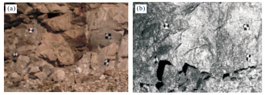
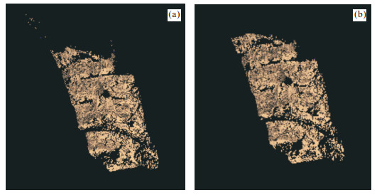
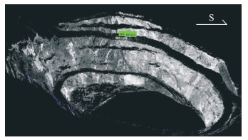
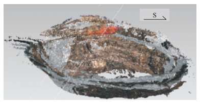
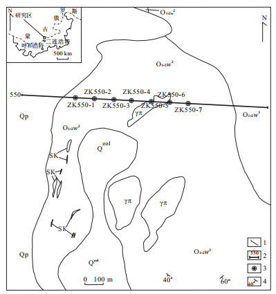
2012, 37(6): 1209-1216.
doi: 10.3799/dqkx.2012.129
Abstract:
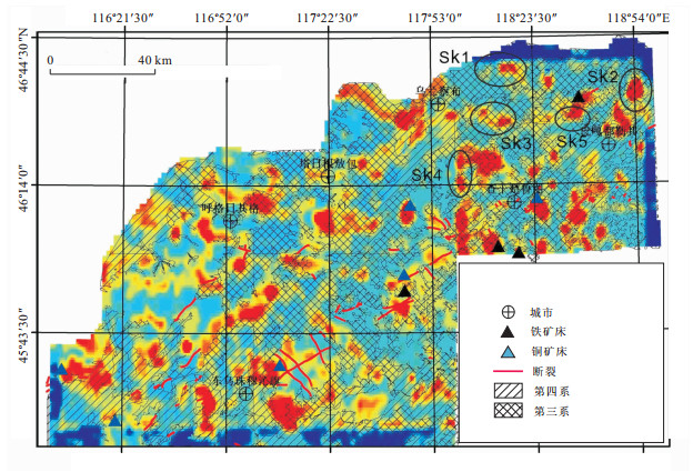
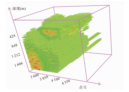
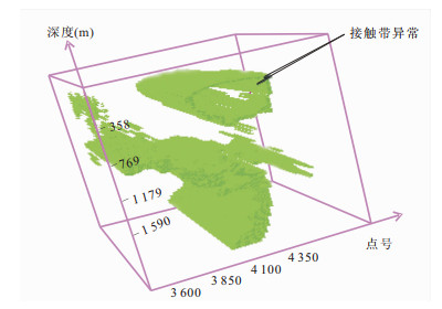
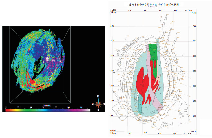
As a new mapping technology, light detection and ranging has been applied in many areas so far. However, for many aspects, such as the alignment of mass data, the location of geographic coordinates and so on, it still suffers some shortages. This paper, focusing on these two issues, puts forward the method of aligning by division parts to solve the problem of the large amounts of data, and to establish the geology modeling by using Rodrigo matrix algorithm to complete the absolute coordinates for the mine, which is a new method of the geological modeling. By comparison with the coordinate data, it indicates that the error of the method is within the allowed value range for mine modeling, with good applicability. Taking the modeling of Baiyinnuo'er Pb-Zn mine area for example, it can facilitate comprehensive mineral resources prediction for the coverage area, especially in perspectives of the 3D deposit modeling and prediction factor spatial characteristics.
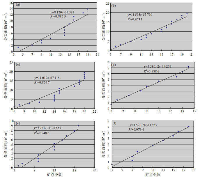
As a new mapping technology, light detection and ranging has been applied in many areas so far. However, for many aspects, such as the alignment of mass data, the location of geographic coordinates and so on, it still suffers some shortages. This paper, focusing on these two issues, puts forward the method of aligning by division parts to solve the problem of the large amounts of data, and to establish the geology modeling by using Rodrigo matrix algorithm to complete the absolute coordinates for the mine, which is a new method of the geological modeling. By comparison with the coordinate data, it indicates that the error of the method is within the allowed value range for mine modeling, with good applicability. Taking the modeling of Baiyinnuo'er Pb-Zn mine area for example, it can facilitate comprehensive mineral resources prediction for the coverage area, especially in perspectives of the 3D deposit modeling and prediction factor spatial characteristics.


2012, 37(6): 1217-1231.
doi: 10.3799/dqkx.2012.130
Abstract:
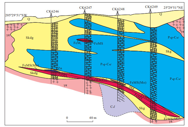
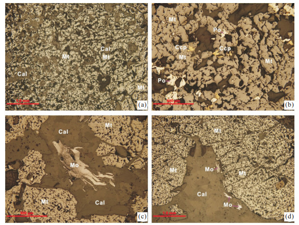
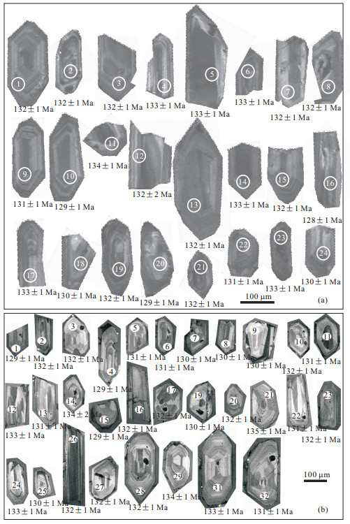
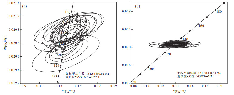
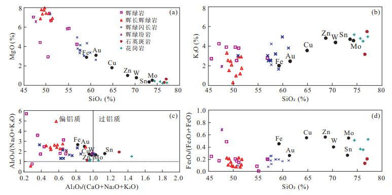
In order to determine the main mineralization time and ore forming genesis in the southwestern Fujian Province, this paper selects the Luoyang iron deposit to develop the study of LA-ICP-MS zircon U-Pb isotopic dating for granite and Re-Os geochronology for molybdenite from the iron ore body. According to the results, the molybdenite Re-Os isotopic model date is (133.0±1.9) to (134.0±4.2) Ma, which belongs to Early Cretaceous; and LA-ICP-MS zircon U-Pb isotopic dates for the granite porphyry and fine grain porphyritic granite are (131±1) Ma and (131.64 ±0.62) Ma respectively, which is very close to the mineralization time achieved by the Re-Os isotopic dating. According to the analysis of the granites, spatial distribution of magnetite and molybdenite ore bodies, and the mineralization and alteration characteristics, combining with the above granite and deposit chronological data, it is suggested that the Luoyang iron deposit mainly formed at Early Cretaceous when the contact thermofluid metasomatism occurred between the Early Cretaceous granites and the Carboniferous clastic and carbonate strata.
In order to determine the main mineralization time and ore forming genesis in the southwestern Fujian Province, this paper selects the Luoyang iron deposit to develop the study of LA-ICP-MS zircon U-Pb isotopic dating for granite and Re-Os geochronology for molybdenite from the iron ore body. According to the results, the molybdenite Re-Os isotopic model date is (133.0±1.9) to (134.0±4.2) Ma, which belongs to Early Cretaceous; and LA-ICP-MS zircon U-Pb isotopic dates for the granite porphyry and fine grain porphyritic granite are (131±1) Ma and (131.64 ±0.62) Ma respectively, which is very close to the mineralization time achieved by the Re-Os isotopic dating. According to the analysis of the granites, spatial distribution of magnetite and molybdenite ore bodies, and the mineralization and alteration characteristics, combining with the above granite and deposit chronological data, it is suggested that the Luoyang iron deposit mainly formed at Early Cretaceous when the contact thermofluid metasomatism occurred between the Early Cretaceous granites and the Carboniferous clastic and carbonate strata.
2012, 37(6): 1232-1242.
doi: 10.3799/dqkx.2012.131
Abstract:
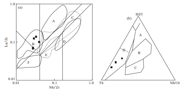
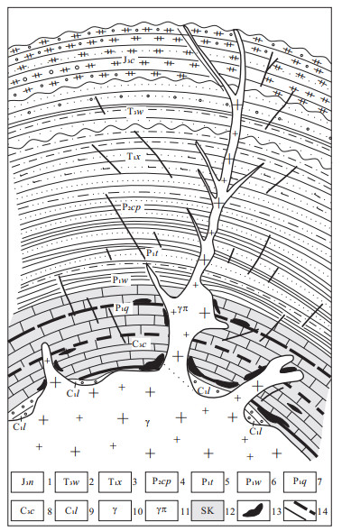
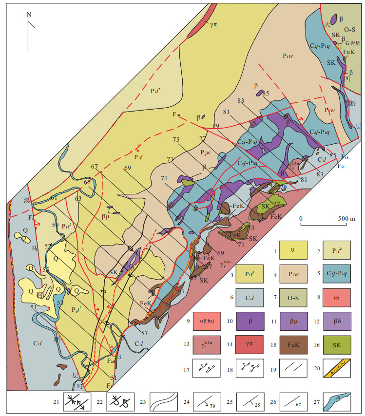
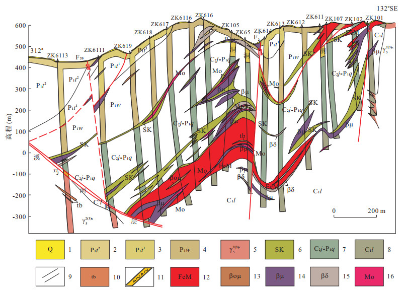
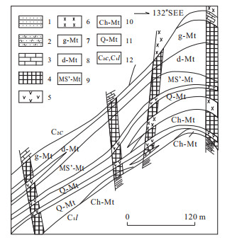
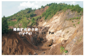
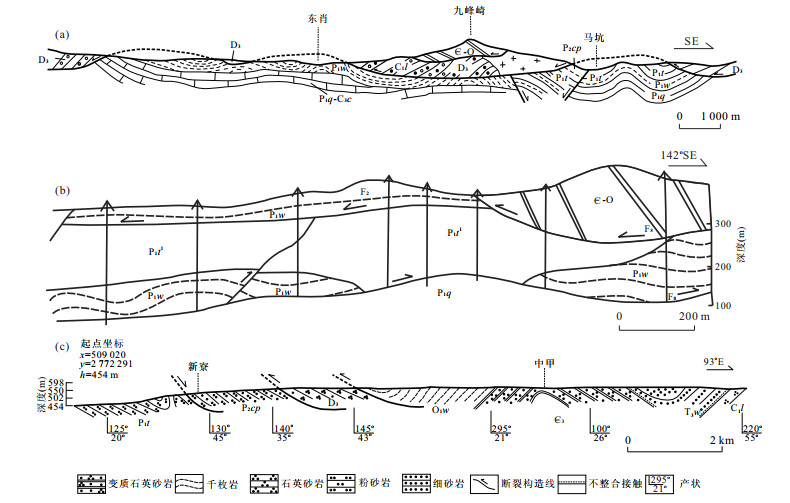
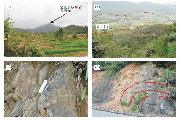
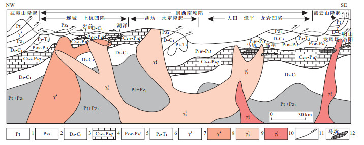
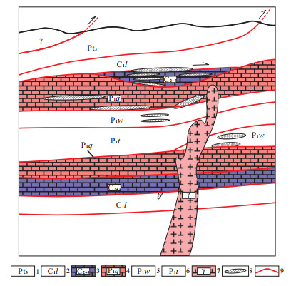
Makeng type iron deposit is a large deposit in the secondary NE-trending Longzhang basal fracture sag zone of the Late Paleozoic depression of Yongmei. The prospecting breakthrough has been hindered due to the fact that we are not very clear about the type of the strata hosted Makeng type iron deposits. On the basis of field investigation and conscientious study of the results of previous researches, this paper explores ore-controlling factors of the Makeng type iron deposit. It is found that the fold in the Makeng mine district is an overturned anticline instead of one limb of the anticline, and that the Yanshanian thrust nappe structure is the results generated by the subduction of Izanagi plate under the Eurasian plate from southeast to northwest. It is suggested that the Jingshe Formation-Qixia Formation (C2j-P1q) and interface between the Jingshe Formation-Qixia Formation (C2j-P1q) and the Wenbishan Formation (P1w) are the horizon hosted Makeng type iron deposit, and that the thrust nappe structure is also important ore-controlling factors. In addition, this paper also presents the prospecting direction.
Makeng type iron deposit is a large deposit in the secondary NE-trending Longzhang basal fracture sag zone of the Late Paleozoic depression of Yongmei. The prospecting breakthrough has been hindered due to the fact that we are not very clear about the type of the strata hosted Makeng type iron deposits. On the basis of field investigation and conscientious study of the results of previous researches, this paper explores ore-controlling factors of the Makeng type iron deposit. It is found that the fold in the Makeng mine district is an overturned anticline instead of one limb of the anticline, and that the Yanshanian thrust nappe structure is the results generated by the subduction of Izanagi plate under the Eurasian plate from southeast to northwest. It is suggested that the Jingshe Formation-Qixia Formation (C2j-P1q) and interface between the Jingshe Formation-Qixia Formation (C2j-P1q) and the Wenbishan Formation (P1w) are the horizon hosted Makeng type iron deposit, and that the thrust nappe structure is also important ore-controlling factors. In addition, this paper also presents the prospecting direction.

2012, 37(6): 1243-1251.
doi: 10.3799/dqkx.2012.132
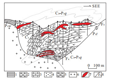
Abstract:
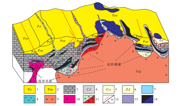
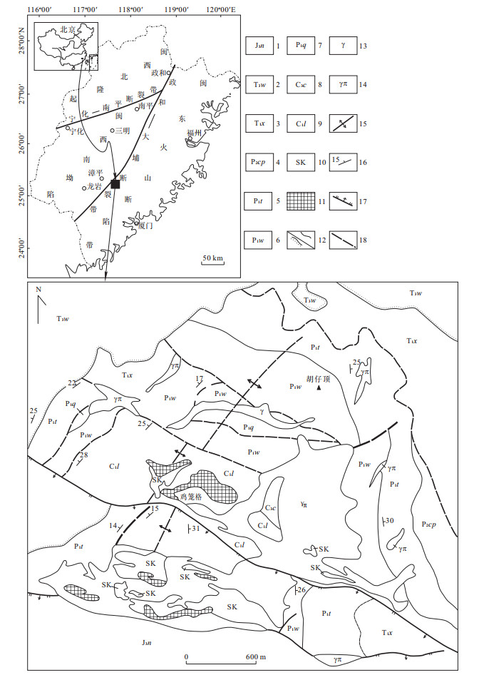
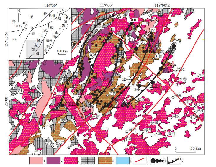
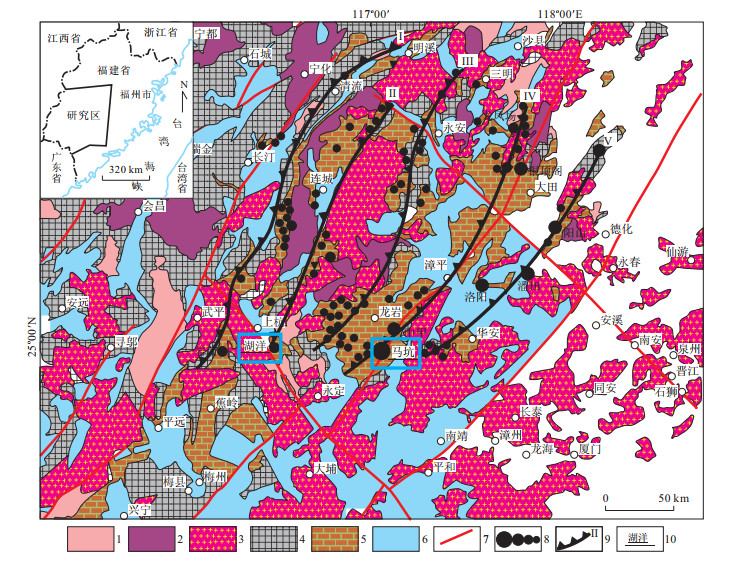
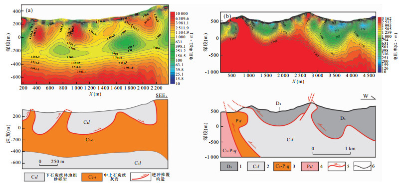
The southwestern Fujian is located in southwestern Wuyishan mineralization zone, where nappe (slippage) structures extensively developed after a multi-stage tectonic evolution since the Proterozoic, with control over "Ma Keng"-small, medium and large iron polymetallic deposits in the region. It is found in this study on nappe structures associated with ore-bearing rocks and nappe interfaces that the ore-bearing strata mainly consist of C2+3-P1q; the nappe mainly occurred along the AnD/C1l and C1l/C2+3+P1q interfaces; and these two regional nappe structures may be the geochemical shield of the hydrothermal ore-forming fluid. A ore-controlling geological-geophysical model of the nappe structure in southwestern Fujian is established by surface geological analysis of distribution and tectonic framework of the deep ore-bearing rock and nappe interface combining the interpretation of deep controlled source audio magnetotelluric method (CSAMT), which will certainly facilitate deep prospecting.
The southwestern Fujian is located in southwestern Wuyishan mineralization zone, where nappe (slippage) structures extensively developed after a multi-stage tectonic evolution since the Proterozoic, with control over "Ma Keng"-small, medium and large iron polymetallic deposits in the region. It is found in this study on nappe structures associated with ore-bearing rocks and nappe interfaces that the ore-bearing strata mainly consist of C2+3-P1q; the nappe mainly occurred along the AnD/C1l and C1l/C2+3+P1q interfaces; and these two regional nappe structures may be the geochemical shield of the hydrothermal ore-forming fluid. A ore-controlling geological-geophysical model of the nappe structure in southwestern Fujian is established by surface geological analysis of distribution and tectonic framework of the deep ore-bearing rock and nappe interface combining the interpretation of deep controlled source audio magnetotelluric method (CSAMT), which will certainly facilitate deep prospecting.
2012, 37(6): 1252-1258.
doi: 10.3799/dqkx.2012.133
Abstract:
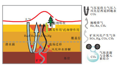
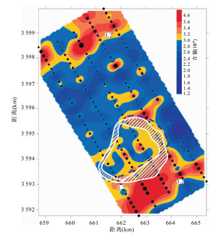
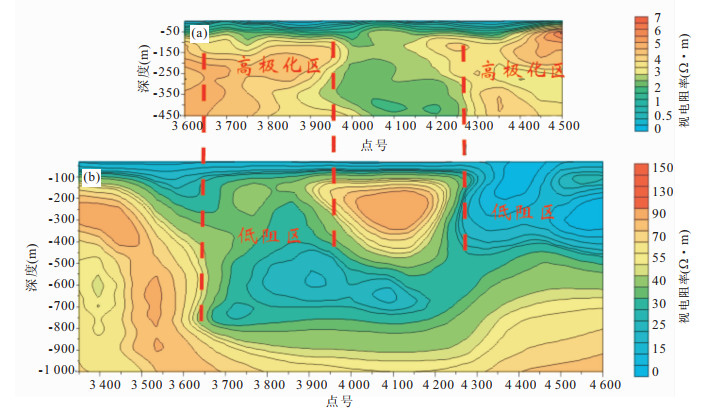
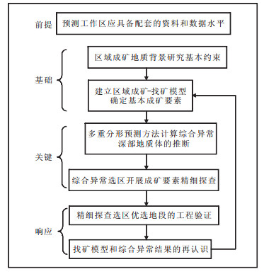
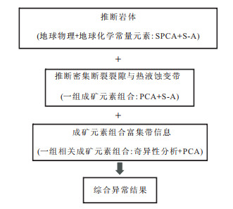
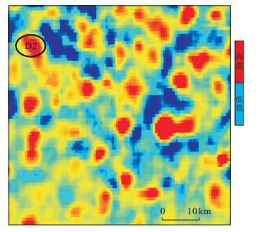
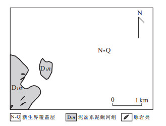
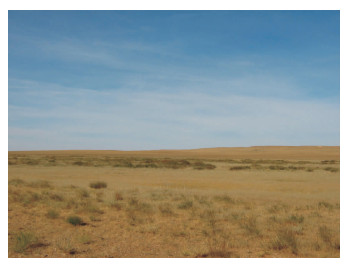
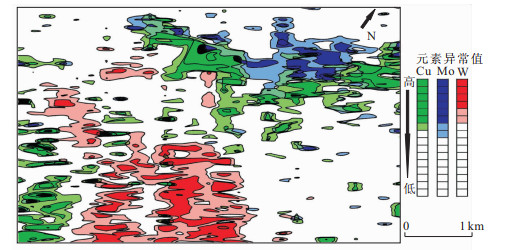
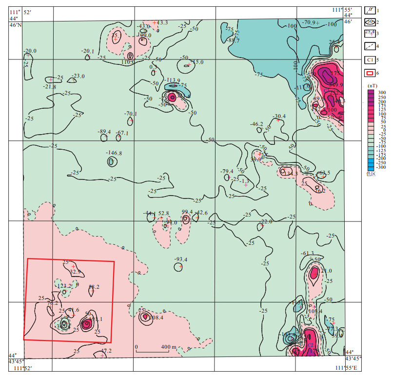
Geological prospection in covered areas is an important issue, which is confronted with a series of problems to be worked out, such as overcoming ore-generated messages faults ranging from weak to sluggish, overlapping, absent to uncompleted faults and to gain effectively the ore-generated information associated with ore bodies in the covered areas. Identifying the main ore elements and type of mineralization, establishing a regional model of ore genesis-prospection and using the method of nonlinear integrated prediction should be better to strengthen and extract mineralized information from the existing geological data. A primary framework of a new approach on integrated geological prospection in covered areas is presented in this paper. With a case study of Northwestern Xilinguole of Inner Mongolia, it shows the approach and result in detail of its application to grassland-covered area for integrated geological prospection.
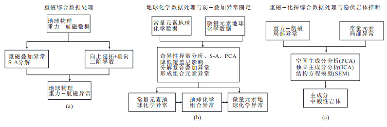
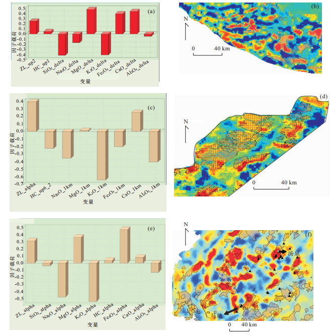
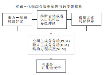
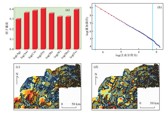
Geological prospection in covered areas is an important issue, which is confronted with a series of problems to be worked out, such as overcoming ore-generated messages faults ranging from weak to sluggish, overlapping, absent to uncompleted faults and to gain effectively the ore-generated information associated with ore bodies in the covered areas. Identifying the main ore elements and type of mineralization, establishing a regional model of ore genesis-prospection and using the method of nonlinear integrated prediction should be better to strengthen and extract mineralized information from the existing geological data. A primary framework of a new approach on integrated geological prospection in covered areas is presented in this paper. With a case study of Northwestern Xilinguole of Inner Mongolia, it shows the approach and result in detail of its application to grassland-covered area for integrated geological prospection.
2012, 37(6): 1259-1267.
doi: 10.3799/dqkx.2012.134
Abstract:
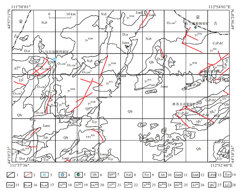
The geological settings,geological characteristics,petrochemical features of tungsten and molybdenum ore deposits in Wurinitu of Sunitezuoqi,Inner Mongolia,are studied in detail,metallogenic relationship between the characteristics of tungsten and molybdenum ore deposit in Wurinitu and that of small neutral and acid rock bodies is explored and the controlling effect of its wall rocks on the mineralization is discussed,and the relationship between the alteration types of the wall rocks is also probed. In addition,geophysical and geochemical features of tungsten and molybdenum deposits,the distribution and evolution laws of the deposits are presented in this paper. It is found that neutral and acid rock bodies in Early Cretaceous granite are source rocks for the metallogenic belt in Erenhot-Dongwuqi-Lizishang and is promising for future tungsten and molybdenum mineral exploration in the grassland of Inner Mongolia.
The geological settings,geological characteristics,petrochemical features of tungsten and molybdenum ore deposits in Wurinitu of Sunitezuoqi,Inner Mongolia,are studied in detail,metallogenic relationship between the characteristics of tungsten and molybdenum ore deposit in Wurinitu and that of small neutral and acid rock bodies is explored and the controlling effect of its wall rocks on the mineralization is discussed,and the relationship between the alteration types of the wall rocks is also probed. In addition,geophysical and geochemical features of tungsten and molybdenum deposits,the distribution and evolution laws of the deposits are presented in this paper. It is found that neutral and acid rock bodies in Early Cretaceous granite are source rocks for the metallogenic belt in Erenhot-Dongwuqi-Lizishang and is promising for future tungsten and molybdenum mineral exploration in the grassland of Inner Mongolia.
2012, 37(6): 1268-1278.
doi: 10.3799/dqkx.2012.135
Abstract:
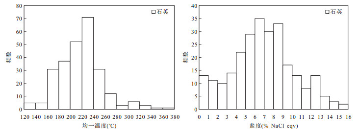
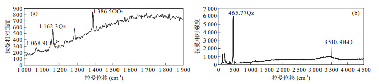
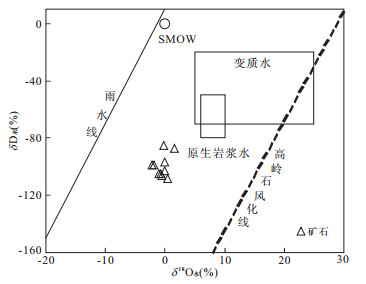
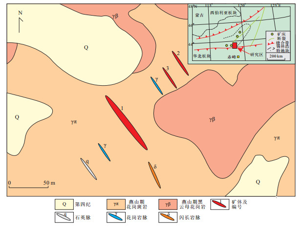
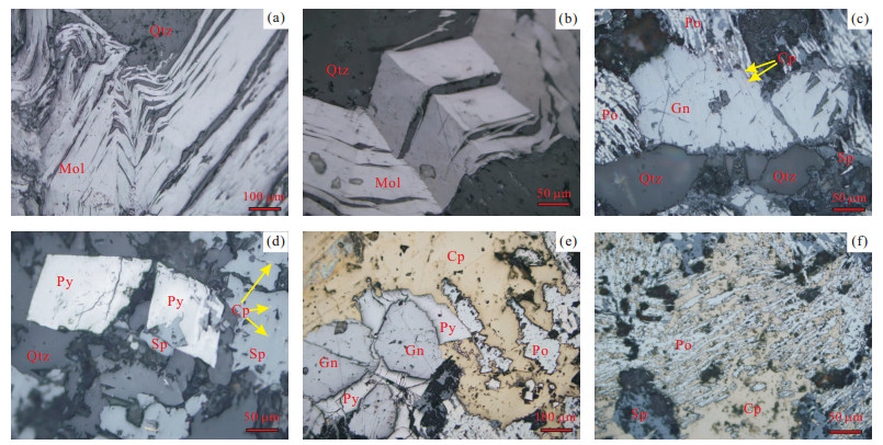
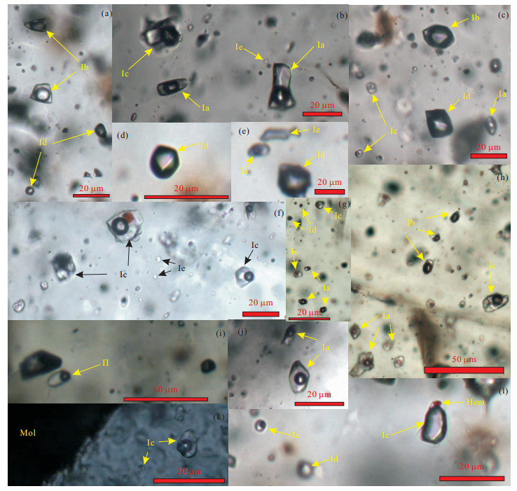
The Wurinitu W-Mo deposit,located in Sunid Zuoqi area in the Inner Mongolia autonomous region,is a large W-Mo deposit discovered in recent years. The W-Mo orebodies mainly occurred in Yanshanian granite rock body and the nearby contact zone,with the major type of veinlet mineralization. Petrographic study of fluid inclusions suggests that the main types of fluid inclusions of Wurinitu metallogenic fluid system are two-phase vapor-liquid inclusions,vapor-rich phase inclusions,liquid-rich phase inclusions and pure liquid phase inclusions. The homogenization temperature and salinity of the fluid inclusions vary in 130.0-371.7 ℃ (the peak value vary in 160-260 ℃) and 0.2%-15.9% NaCl eqv (the peak value vary in 0.2%-12.5% NaCl eqv). The deposit belongs to a medium-low temperature,medium-low salinity W-Mo deposit. Laser Raman spectroscopic and inclusion groups components studies indicate that gas composition of the ore-forming fluid are mainly H2O and CO2,some N2 and O2,and less CO,CH4,C2H2,C2H4 and C2H6,liquid composition are mainly Ca2+,Na+,SO42-,Cl-,some K+,F-,Mg2+ and NO3-,and less Br- and Li+. The ore-forming fluids belong to the H2O-NaCl-CO2 system. The hydrogen and oxygen isotopic compositions of fluid inclusions showed that the ore-forming fluids had lower values of δ18Owater ranging from -2.11% to -0.11%,and the value of δDwater ranged from -85% to -108%. The ore-forming fluids came from the mixing of magma water and meteoric water. Based on the geological and ore-forming fluids characteristics of the deposit,it is concluded that the Wurinitu quartz vein type W-Mo deposit is a Yanshanian magmatism-related and moderate-low temperature hydrothermal system. The ore-forming materials were mainly derived from the depth.
The Wurinitu W-Mo deposit,located in Sunid Zuoqi area in the Inner Mongolia autonomous region,is a large W-Mo deposit discovered in recent years. The W-Mo orebodies mainly occurred in Yanshanian granite rock body and the nearby contact zone,with the major type of veinlet mineralization. Petrographic study of fluid inclusions suggests that the main types of fluid inclusions of Wurinitu metallogenic fluid system are two-phase vapor-liquid inclusions,vapor-rich phase inclusions,liquid-rich phase inclusions and pure liquid phase inclusions. The homogenization temperature and salinity of the fluid inclusions vary in 130.0-371.7 ℃ (the peak value vary in 160-260 ℃) and 0.2%-15.9% NaCl eqv (the peak value vary in 0.2%-12.5% NaCl eqv). The deposit belongs to a medium-low temperature,medium-low salinity W-Mo deposit. Laser Raman spectroscopic and inclusion groups components studies indicate that gas composition of the ore-forming fluid are mainly H2O and CO2,some N2 and O2,and less CO,CH4,C2H2,C2H4 and C2H6,liquid composition are mainly Ca2+,Na+,SO42-,Cl-,some K+,F-,Mg2+ and NO3-,and less Br- and Li+. The ore-forming fluids belong to the H2O-NaCl-CO2 system. The hydrogen and oxygen isotopic compositions of fluid inclusions showed that the ore-forming fluids had lower values of δ18Owater ranging from -2.11% to -0.11%,and the value of δDwater ranged from -85% to -108%. The ore-forming fluids came from the mixing of magma water and meteoric water. Based on the geological and ore-forming fluids characteristics of the deposit,it is concluded that the Wurinitu quartz vein type W-Mo deposit is a Yanshanian magmatism-related and moderate-low temperature hydrothermal system. The ore-forming materials were mainly derived from the depth.

2012, 37(6): 1279-1290.
doi: 10.3799/dqkx.2012.136
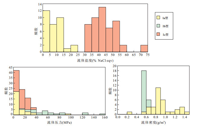
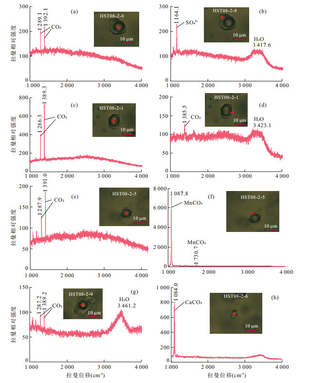
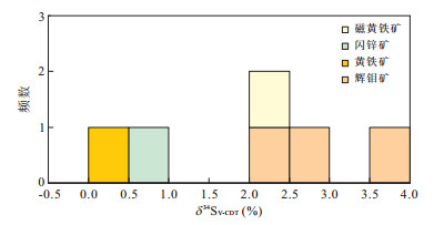
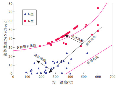
Abstract:
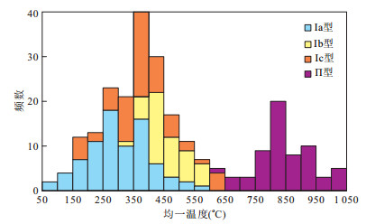
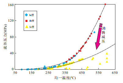
The Hashitu Mo deposit was discovered recently in the middle section of the Da Hinggan Montain district. The ore body occurs in granite intrusion and this deposit is regarded as an endogenic metallic ore deposit related to acid magmatism. The metallic minerals are composed of molybdenite,chalcopyrite,pyrite,sphalerite,galena,and arsenopyrite,etc. The fluid inclusions study demonstrates that inclusion types mainly involve liquid inclusion (Ia type),gaseous inclusion (Ib type),daughter crystal inclusion (Ic type) and melt inclusion (II type). Co-existence of different inclusion types indicates the fluid boiling. The heating and freezing study shows that homogenization temperature of fluid and melt inclusions ranges 250~500 ℃ and 750~950 ℃,respectively. The calculation of fluid salinity,pressure and density indicates that these values range 1%~49% NaCl eqv,5~100 MPa and 0.7~1.1 g/cm3,respectively. The fluid inclusion study indicates that ore forming fluid are characterized by high temperature,high salinity,high pressure,high-moderate density and CO2 bearing,which can be classified as H2O-NaCl-CO2-SO42- system. δ34Sv-cdt(‰) values of sulfides and δ34SH2S(‰) values of ore forming fluid range from 0.4‰ to 3.8‰ and 1.1‰ to 4.7‰,respectively. These isotopic values indicate that mineralization is related with magmatism in this region. Both fluid boiling and mixing are identified in ore forming fluid evolution and fluid boiling resulting in pressure decrease was the mainly mechanism for sulfide minerals deposition form hydrothermal fluid. Discovery of the Hashitu Mo deposit in this region is helpful to the exploration of other magmatic-hydrothermal Mo-W-Cu-Pb-Zn-Au deposits. More attention should be paid to the contact and intersection parts between intrusions and other host rocks,intrusions and structural zones in future mining exploration.
The Hashitu Mo deposit was discovered recently in the middle section of the Da Hinggan Montain district. The ore body occurs in granite intrusion and this deposit is regarded as an endogenic metallic ore deposit related to acid magmatism. The metallic minerals are composed of molybdenite,chalcopyrite,pyrite,sphalerite,galena,and arsenopyrite,etc. The fluid inclusions study demonstrates that inclusion types mainly involve liquid inclusion (Ia type),gaseous inclusion (Ib type),daughter crystal inclusion (Ic type) and melt inclusion (II type). Co-existence of different inclusion types indicates the fluid boiling. The heating and freezing study shows that homogenization temperature of fluid and melt inclusions ranges 250~500 ℃ and 750~950 ℃,respectively. The calculation of fluid salinity,pressure and density indicates that these values range 1%~49% NaCl eqv,5~100 MPa and 0.7~1.1 g/cm3,respectively. The fluid inclusion study indicates that ore forming fluid are characterized by high temperature,high salinity,high pressure,high-moderate density and CO2 bearing,which can be classified as H2O-NaCl-CO2-SO42- system. δ34Sv-cdt(‰) values of sulfides and δ34SH2S(‰) values of ore forming fluid range from 0.4‰ to 3.8‰ and 1.1‰ to 4.7‰,respectively. These isotopic values indicate that mineralization is related with magmatism in this region. Both fluid boiling and mixing are identified in ore forming fluid evolution and fluid boiling resulting in pressure decrease was the mainly mechanism for sulfide minerals deposition form hydrothermal fluid. Discovery of the Hashitu Mo deposit in this region is helpful to the exploration of other magmatic-hydrothermal Mo-W-Cu-Pb-Zn-Au deposits. More attention should be paid to the contact and intersection parts between intrusions and other host rocks,intrusions and structural zones in future mining exploration.
2012, 37(6): 1291-1304.
doi: 10.3799/dqkx.2012.137
Abstract:
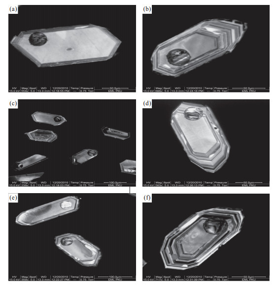
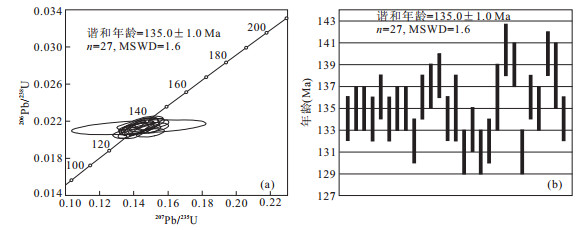
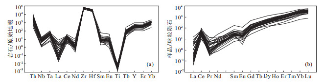
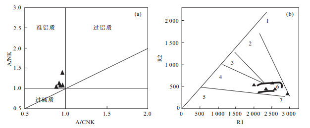
The Aolunhua Mo deposit is a typical porphyry deposit,which is located in middle southern section of the Da Hinggan metallogenic belt. In order to determinate the petrogenetic ages of the deposit,we focus our study on granite zircons LA-ICP-MS. Combined with the trace element geochemistry in granites zircons,we discuss in-depth the ore-forming rock's material sources of the deposit. The granite zircons LA-ICP-MS analysis shows that the crystallization age of the granite is 135.0±1.0 Ma,indicating that the granite related with mineralization resulted from magmatism in Early Cretaceous period. The Th/U ratios of the ore-forming rock is greater than 0.1 with a significant positive Ce anomaly(Ce*=1.72~188.71) and negative Eu anomalies (Eu*=0.05~0.57). It can be concluded that crust-derived magmatic zircon is characterized by poor LREE,rich HREE,low La,Pr content and positive Ce anomaly. Combined with ore deposit geology and mineralization epoch as well as regional tectonic evolution,we draw a conclusion that formation of the Aolunhua Mo deposit is in the peak metallogenic epoch as 140 Ma in the Da Hinggan region. The tectonic settings of the deposit are in the transition period from lithosphere compression to extension. We think that the Tianshan-Linxi is a crustal type section,it has an important role for research this area. At the same time,we contrast some newly discovered Mo deposits along north bank of Xilamulun River,and find that Tianshan-Linxi is an important Mo ore-forming belt,which facilitates the understanding of regional controlling tectonics and prospecting of the ore deposits.
The Aolunhua Mo deposit is a typical porphyry deposit,which is located in middle southern section of the Da Hinggan metallogenic belt. In order to determinate the petrogenetic ages of the deposit,we focus our study on granite zircons LA-ICP-MS. Combined with the trace element geochemistry in granites zircons,we discuss in-depth the ore-forming rock's material sources of the deposit. The granite zircons LA-ICP-MS analysis shows that the crystallization age of the granite is 135.0±1.0 Ma,indicating that the granite related with mineralization resulted from magmatism in Early Cretaceous period. The Th/U ratios of the ore-forming rock is greater than 0.1 with a significant positive Ce anomaly(Ce*=1.72~188.71) and negative Eu anomalies (Eu*=0.05~0.57). It can be concluded that crust-derived magmatic zircon is characterized by poor LREE,rich HREE,low La,Pr content and positive Ce anomaly. Combined with ore deposit geology and mineralization epoch as well as regional tectonic evolution,we draw a conclusion that formation of the Aolunhua Mo deposit is in the peak metallogenic epoch as 140 Ma in the Da Hinggan region. The tectonic settings of the deposit are in the transition period from lithosphere compression to extension. We think that the Tianshan-Linxi is a crustal type section,it has an important role for research this area. At the same time,we contrast some newly discovered Mo deposits along north bank of Xilamulun River,and find that Tianshan-Linxi is an important Mo ore-forming belt,which facilitates the understanding of regional controlling tectonics and prospecting of the ore deposits.
2012, 37(6): 1305-1314.
doi: 10.3799/dqkx.2012.138
Abstract:
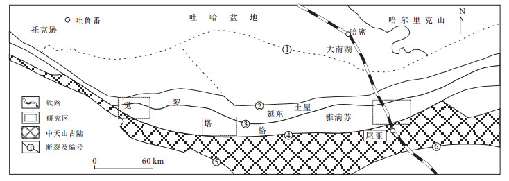
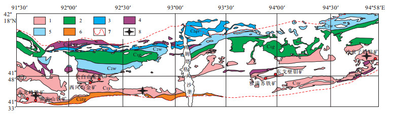
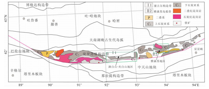
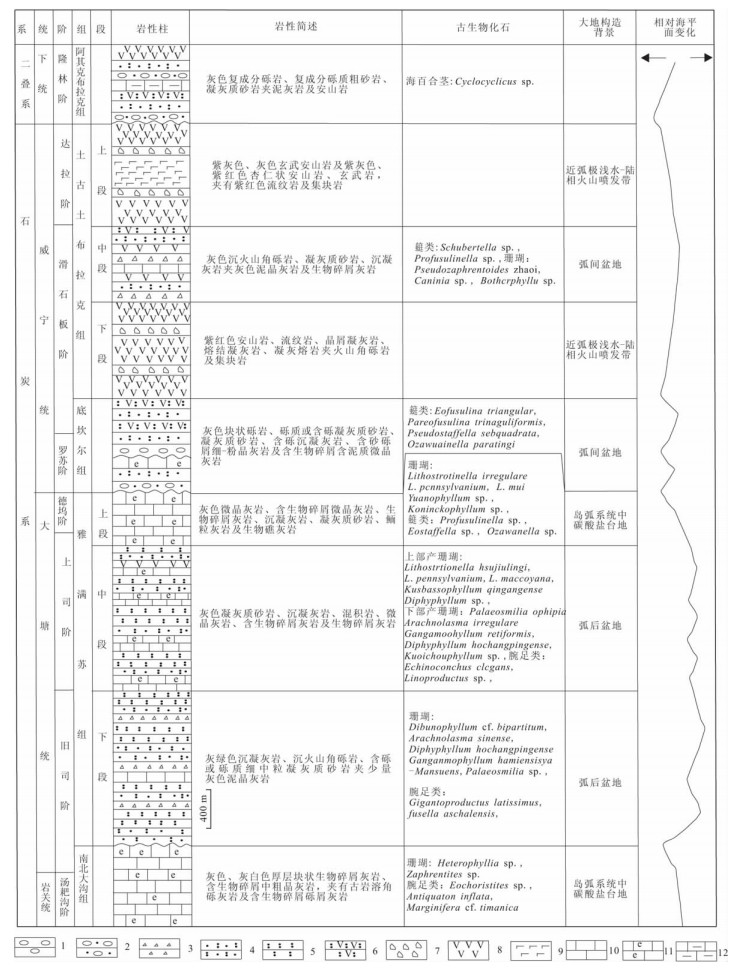
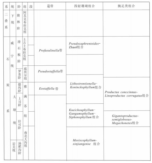
By the study on the Carboniferous biostratigraphy and geological age in Lubaishan,Jiabaishan and Yamansu areas in Jueluotage,the Carboniferous sequence is revised,and the fusulinid zone,coral assemblages and brachiopod assemblages are divided. It is suggested that the geological age of Lower and Middle member of Yamansu Formation is Jiusian-Shangsian in the Early Carboniferous; while the Upper member is Dewuan,and the strata of volcanic deposit which is correlated with the marine volcanic type iron is Jiusian. What's more,these fossil assemblages indicate that the age of Dikanr Formation is Luosuan in the Late Carboniferous,and the age of Tugutu Bulak Formation is Huashibanian,volcanics horizon here was forming in Huashibanian. Besides,this paper suggests that the Xiaorequanzi Formation should be abandoned since this formation can belong to the Middle-Lower part of Yamansu Formation in this area. The geotectonic background of Carboniferous is also discussed in this paper.
By the study on the Carboniferous biostratigraphy and geological age in Lubaishan,Jiabaishan and Yamansu areas in Jueluotage,the Carboniferous sequence is revised,and the fusulinid zone,coral assemblages and brachiopod assemblages are divided. It is suggested that the geological age of Lower and Middle member of Yamansu Formation is Jiusian-Shangsian in the Early Carboniferous; while the Upper member is Dewuan,and the strata of volcanic deposit which is correlated with the marine volcanic type iron is Jiusian. What's more,these fossil assemblages indicate that the age of Dikanr Formation is Luosuan in the Late Carboniferous,and the age of Tugutu Bulak Formation is Huashibanian,volcanics horizon here was forming in Huashibanian. Besides,this paper suggests that the Xiaorequanzi Formation should be abandoned since this formation can belong to the Middle-Lower part of Yamansu Formation in this area. The geotectonic background of Carboniferous is also discussed in this paper.
2012, 37(6): 1315-1326.
doi: 10.3799/dqkx.2012.139
Abstract:
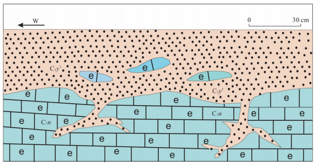
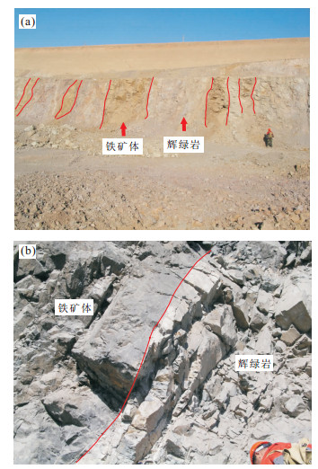
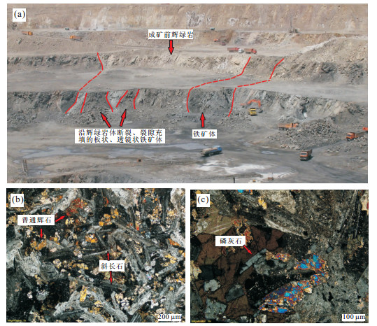
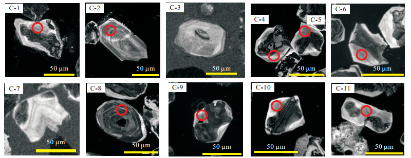
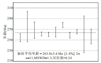
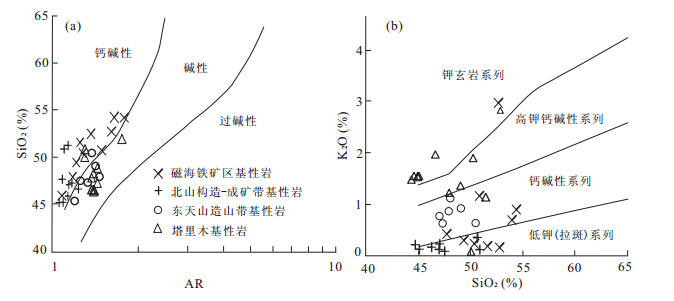
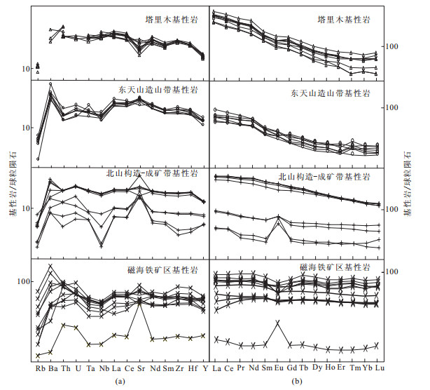
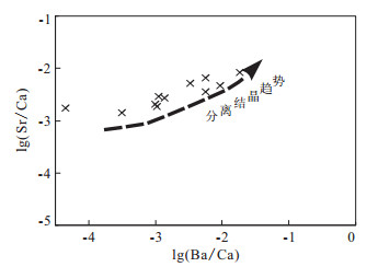
The basic igneous rock in Cihai giant iron district has a close relationship with the iron mineralization which is the key to understanding of the larger scale of iron metallization and the metallogenic setting. The diabase is the main basic igneous rock in Cihai iron district,and the platy iron-vein group are hosted by the fault-fissures in diabase; the U-Pb dating of single-grained zircon from diabase yielded an average weighted 206Pb/238U age of 263.8±3.6 Ma (n=11,MSWD=1.3)which is contemporary with that of the basic igneous rock in Permian Tarim basin,eastern Tianshan orogenic belt and Beishan tectonic-metallogenic belt. The trace elements chondrite-normalized patterns of basic igneous rock in Cihai iron district are relatively flat with Sr,Ba enriched and Nb lost lightly; the REE chondrite-normalized patterns are flat. The content of trace elements and magmatic nature of basic igneous rock in Cihai iron district are similar to that of the basic igneous rocks in Permian Tarim basin,eastern Tianshan orogenic belt and Beishan tectonic-metallogenic belt and they all belong to alkaline-calc-alkaline series with close genetic relationship; the basic igneous magma of Cihai district most possibly originated from asthenospheric mantle. The basic igneous rock in Cihai district is possibly a part of Tarim large igneous provinces formed by Permian mantle plum; and the large scale of iron mineralization are also formed in the setting of mantle plum which is a branch of mantle plum in Tarim basin as Beishan tectonic-metallogenic belt.
The basic igneous rock in Cihai giant iron district has a close relationship with the iron mineralization which is the key to understanding of the larger scale of iron metallization and the metallogenic setting. The diabase is the main basic igneous rock in Cihai iron district,and the platy iron-vein group are hosted by the fault-fissures in diabase; the U-Pb dating of single-grained zircon from diabase yielded an average weighted 206Pb/238U age of 263.8±3.6 Ma (n=11,MSWD=1.3)which is contemporary with that of the basic igneous rock in Permian Tarim basin,eastern Tianshan orogenic belt and Beishan tectonic-metallogenic belt. The trace elements chondrite-normalized patterns of basic igneous rock in Cihai iron district are relatively flat with Sr,Ba enriched and Nb lost lightly; the REE chondrite-normalized patterns are flat. The content of trace elements and magmatic nature of basic igneous rock in Cihai iron district are similar to that of the basic igneous rocks in Permian Tarim basin,eastern Tianshan orogenic belt and Beishan tectonic-metallogenic belt and they all belong to alkaline-calc-alkaline series with close genetic relationship; the basic igneous magma of Cihai district most possibly originated from asthenospheric mantle. The basic igneous rock in Cihai district is possibly a part of Tarim large igneous provinces formed by Permian mantle plum; and the large scale of iron mineralization are also formed in the setting of mantle plum which is a branch of mantle plum in Tarim basin as Beishan tectonic-metallogenic belt.
2012, 37(6): 1327-1337.
doi: 10.3799/dqkx.2012.140
Abstract:
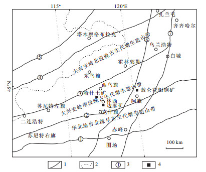
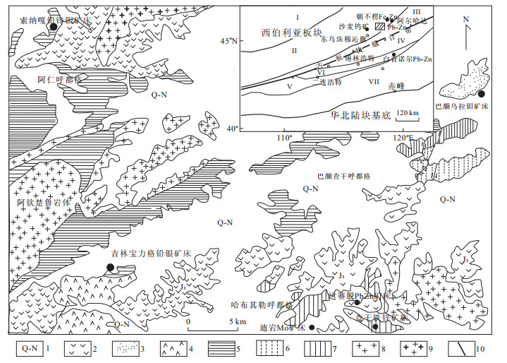
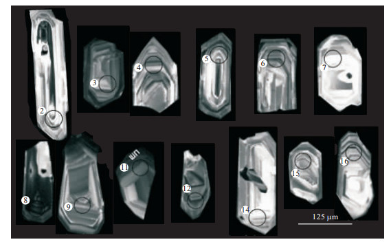
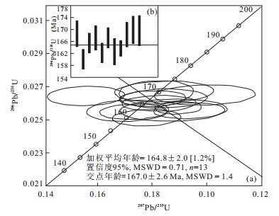
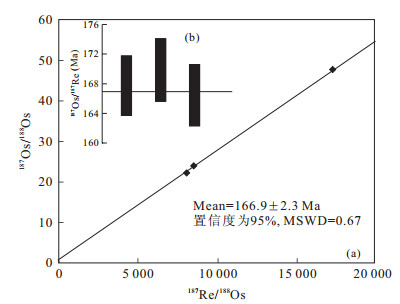
Suo Naga molybdenum-lead-zinc ore deposit has been discovered in Erenhot-Dong Ujimqin Banner metal metallogenic belt in recent years following the discovery of Di Yan porphyry molybdenum deposit. It is characterized by vienlet-type porphyry molybdenum and vien-type lead-zinc mineralization. By using in situ zircon LA-ICP-MS U-Pb and molybdenite ICP-MS Re-Os highly precise dating techniques,one zircon sample from Suo Naga granite-porphyry related to mineralization,and three samples of molybdenum from Mo ores are determined. Zircon 206Pb/238U Weighted mean age of 164.8±2.0 Ma (MSWD=0.71),concordant curve intercepts at 167.8±2.6 Ma (MSWD=1.4) Ma and molybenite 187Re-187Os weighted mean age of 127.82±0.87 Ma are obtained respectively. The results show that the age of granitic magma intrusion corresponds to that of mineralization in the range of deviation. An important metallogenic event,which occurred during early Yanshanian(167 Ma ±) at Erenhot-Dong Ujimqin Banner metal metallogenic belt,was confirmed. The time limit corresponds to that of large scale volcanic eruption in northern region of Inner Mongolia at early stage during Mesozoic period. By comprehensive analysis,it is proposed that the two important metallogenic events are respectively related to twice large-scale volcanic eruptions and intrusions during Mesozoic period in Dong Ujimqin Banner region and even southern area of Hinggan mountains.
Suo Naga molybdenum-lead-zinc ore deposit has been discovered in Erenhot-Dong Ujimqin Banner metal metallogenic belt in recent years following the discovery of Di Yan porphyry molybdenum deposit. It is characterized by vienlet-type porphyry molybdenum and vien-type lead-zinc mineralization. By using in situ zircon LA-ICP-MS U-Pb and molybdenite ICP-MS Re-Os highly precise dating techniques,one zircon sample from Suo Naga granite-porphyry related to mineralization,and three samples of molybdenum from Mo ores are determined. Zircon 206Pb/238U Weighted mean age of 164.8±2.0 Ma (MSWD=0.71),concordant curve intercepts at 167.8±2.6 Ma (MSWD=1.4) Ma and molybenite 187Re-187Os weighted mean age of 127.82±0.87 Ma are obtained respectively. The results show that the age of granitic magma intrusion corresponds to that of mineralization in the range of deviation. An important metallogenic event,which occurred during early Yanshanian(167 Ma ±) at Erenhot-Dong Ujimqin Banner metal metallogenic belt,was confirmed. The time limit corresponds to that of large scale volcanic eruption in northern region of Inner Mongolia at early stage during Mesozoic period. By comprehensive analysis,it is proposed that the two important metallogenic events are respectively related to twice large-scale volcanic eruptions and intrusions during Mesozoic period in Dong Ujimqin Banner region and even southern area of Hinggan mountains.

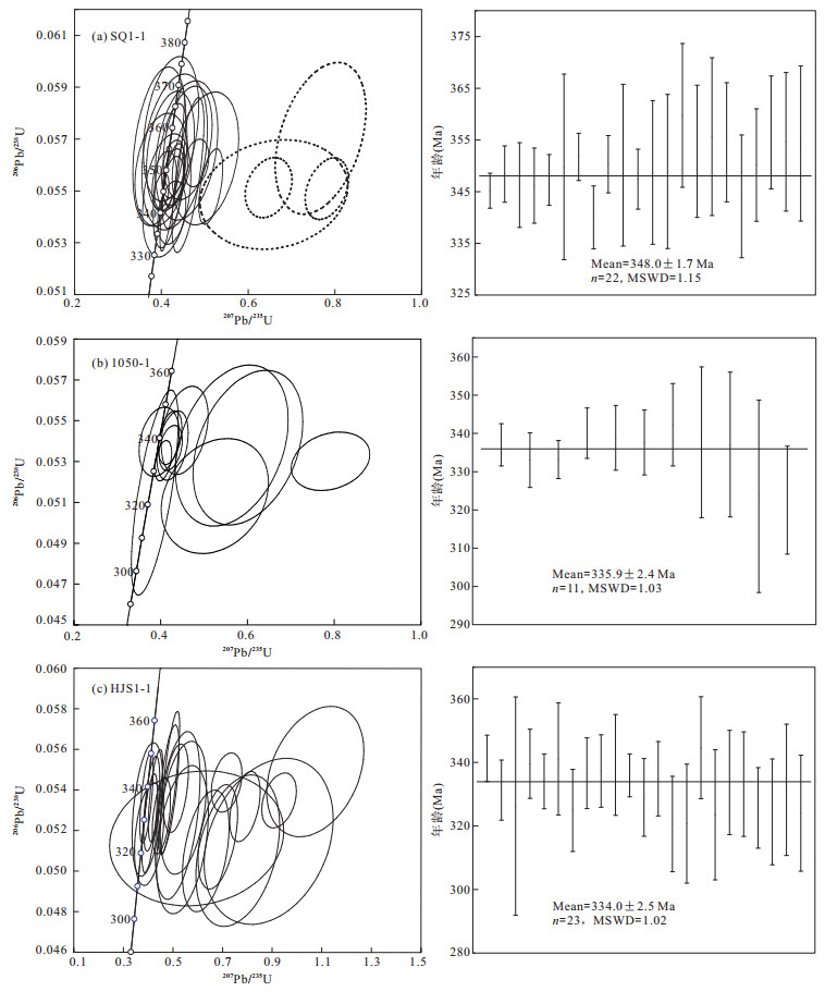
2012, 37(6): 1338-1352.
doi: 10.3799/dqkx.2012.141
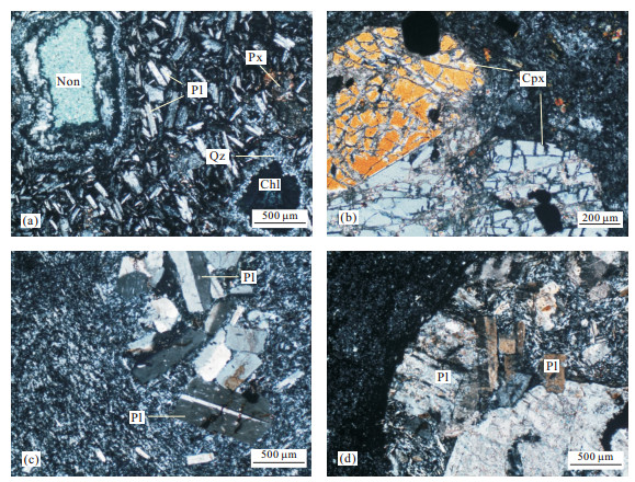
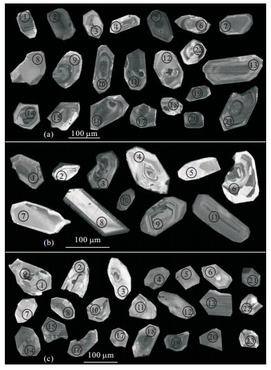
Abstract:
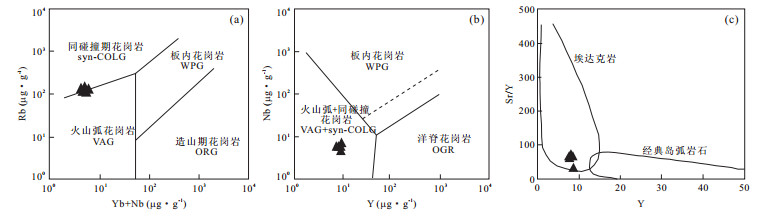
This paper presents the geochemical characteristics and isotope chronology of volcanics from Yamansu Formation,occurring in Jueluotage tectonic belt in the eastern Tianshan of China. Petrological,isotope chronology and geochemical features of these volcanic rocks show that: (1) Yamansu Formation is composed of basite-mesite-acidic volcanic rock,pyroclastic rocks and pyroclastic sedimentary rocks. And it is mainly of calc-alkaline series. The geochemical characteristics demonstrated and inherited zircon age suggests that Yamansu volcanic rocks were formed at arc settings with continental basement. (2) In situ zircon U-Pb LA-ICP-MS dating on the zircon of Yamansu Formation yielded an age of 348.0±1.7 Ma (MSWD=1.15) in the eastern section,335.9±2.4 Ma(MSWD=1.03)in the middle and 334.0±2.5 Ma (MSWD=1.02) in the western section,which stands for volcanic age. (3)The magmatic activity started from the east and then developed to the middle and western sections,like the close of scissors.
This paper presents the geochemical characteristics and isotope chronology of volcanics from Yamansu Formation,occurring in Jueluotage tectonic belt in the eastern Tianshan of China. Petrological,isotope chronology and geochemical features of these volcanic rocks show that: (1) Yamansu Formation is composed of basite-mesite-acidic volcanic rock,pyroclastic rocks and pyroclastic sedimentary rocks. And it is mainly of calc-alkaline series. The geochemical characteristics demonstrated and inherited zircon age suggests that Yamansu volcanic rocks were formed at arc settings with continental basement. (2) In situ zircon U-Pb LA-ICP-MS dating on the zircon of Yamansu Formation yielded an age of 348.0±1.7 Ma (MSWD=1.15) in the eastern section,335.9±2.4 Ma(MSWD=1.03)in the middle and 334.0±2.5 Ma (MSWD=1.02) in the western section,which stands for volcanic age. (3)The magmatic activity started from the east and then developed to the middle and western sections,like the close of scissors.