2020 Vol. 45, No. 11
Display Method:
 PDF 980KB
2020, 45(11): 4197-4197.
Abstract:
2020, 45(11): 3885-3899.
doi: 10.3799/dqkx.2020.246
Abstract:
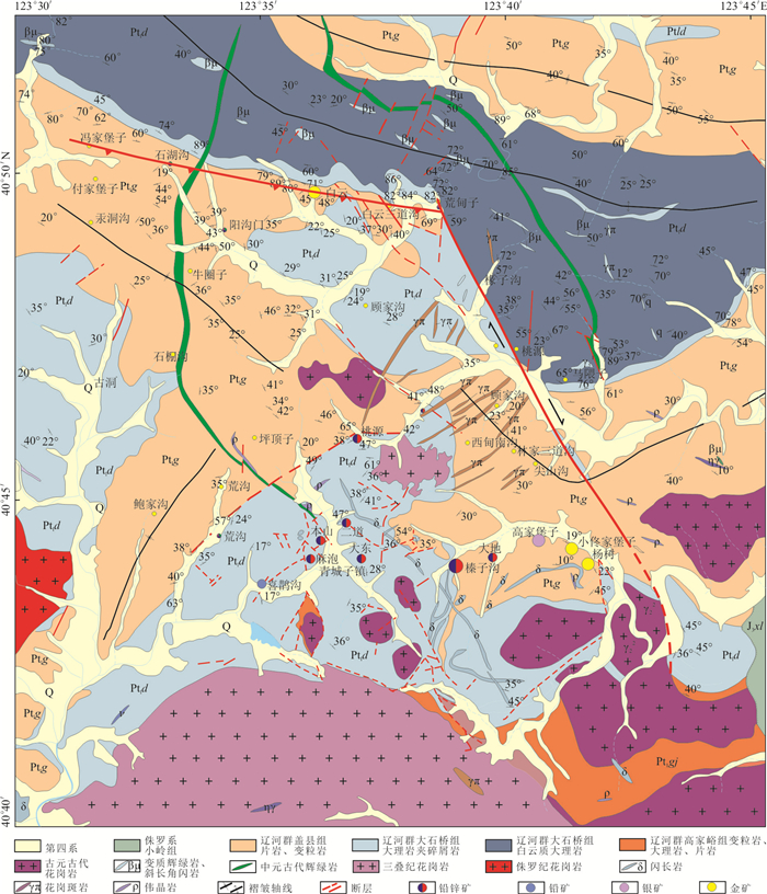
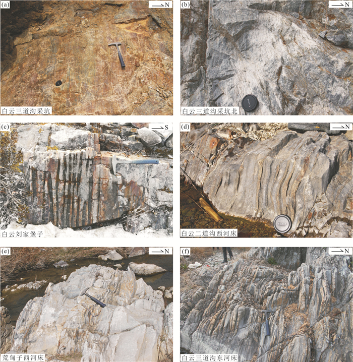
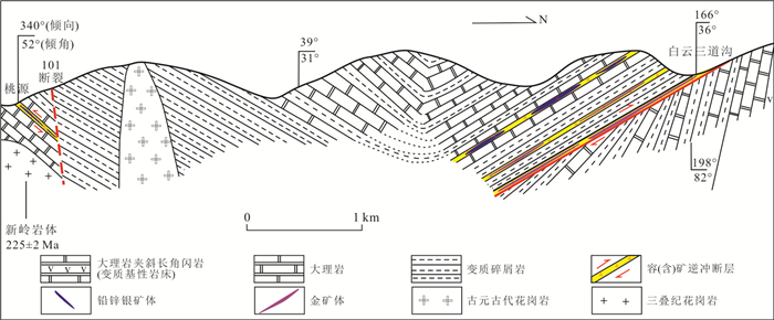
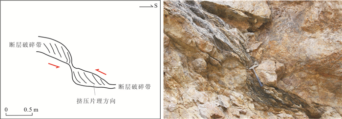
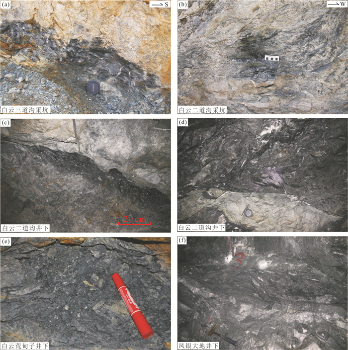
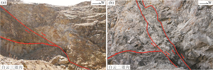
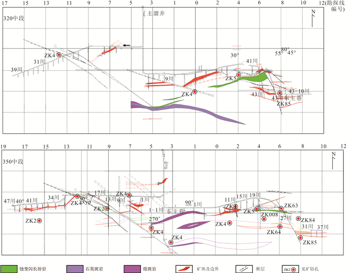
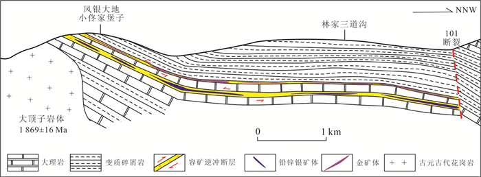
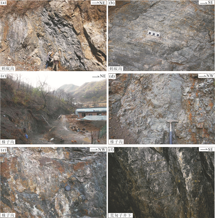
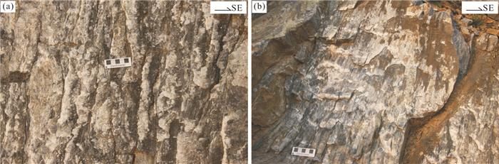
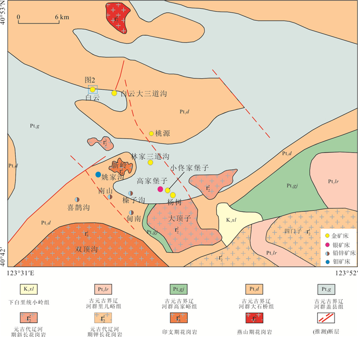
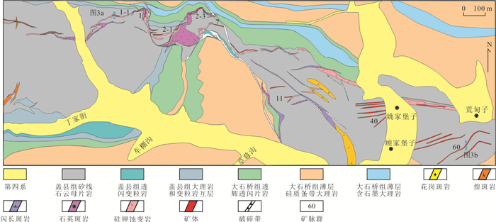
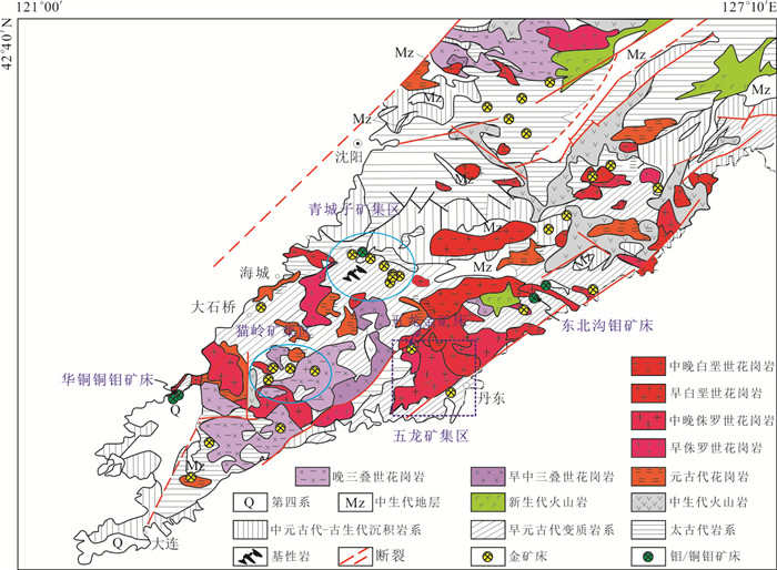
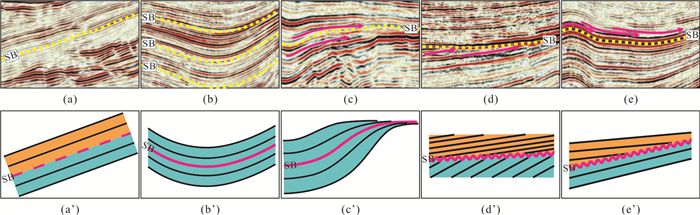
The Baiyun-Xiaotongjiabuzi ore concentration area is one main part of the Qingchengzi ore concentration areas in eastern Liaoning Province. It consists of Baiyun (Erdaogou,Sandaogou) and Huangdianzi gold ore deposits in the north and Linjiasandaogou,Xiaotongjiabuzi,Yangshu,Taoyuan gold ore deposits and Gaojiabuzi,Fengyindadi and Jiangjiagou Ag ore deposits in the south. The results show that the Baiyun (Erdaogou,Sandaogou) and Huangdianzi gold ore deposits in the north are controlled by east-west striking thrust fault system that is about 8 km long along its strike. The ore-hosting thrust fault system dips to south with an average dipping angle of 30°. It is composed of a main thrust fault and several paralleling thrust faults and is about 200 m wide. The main thrust fault cut through the foliations of Dashiqiao and Gaixian formations and other paralleling thrust faults are usually developed along foliations of Dashiqiao and Gaixian formations. The thrust faults are characterized by wave-like surface and the thrust surfaces with low angle are favorable areas for ore bodies. The Linjiasandaogou,Xiaotongjiabuzi,Yangshu,Taoyuan gold ore deposits and Gaojiabuzi,Fengyindadi and Jiangjiagou Ag ore deposits in the south are controlled by north-dipping low angle thrust fault. The ore-hosting thrust faults are developed near the contacts between the metaclastic rocks of Gaixian Formation and marbles of Dashiqiao Formation. Gold and Pb-Zn-Ag ore bodies exist within the thrust faults developed in the metaclastic rocks and marbles,respectively. The NW striking Jianshanzi fault is the largest and high angle fault in the area with a length over 13 km. Field investigation and kinematic analysis results show that the Jianshanzi fault is a multi-stage fault and served as dextral strike-slip in early stage and normal fault in late stage. After formation of the main gold and Pb-Zn-Ag ore deposits in the Baiyun-Xiaotongjiabuzi ore concentration area during the Triassic period,the Jianshanzi fault exhibited strong dextral strike-slip movement and the east-west striking ore-hosting thrust fault system in Baiyun-Huangdianzi ore deposits in west side of the Jianshanzi fault was most likely moved 6 km to south to the Hujiabuzi-north Maweizi-Maodianzi area in east side of the Jianshanzi fault. Based on the analysis results on the ore-controlling structures,ore-bearing strata and movements of the post-metallogenic faults,it is proposed south Baiyun-Huangdianzi ore deposits and Xiaotongjiabuzi-Fengyindadi as two deep metallogenic favorable areas,and Hujiabuzi-north Maweizi-Maodianzi and South Taoyuan village as two outside metallogenic favorable areas.
The Baiyun-Xiaotongjiabuzi ore concentration area is one main part of the Qingchengzi ore concentration areas in eastern Liaoning Province. It consists of Baiyun (Erdaogou,Sandaogou) and Huangdianzi gold ore deposits in the north and Linjiasandaogou,Xiaotongjiabuzi,Yangshu,Taoyuan gold ore deposits and Gaojiabuzi,Fengyindadi and Jiangjiagou Ag ore deposits in the south. The results show that the Baiyun (Erdaogou,Sandaogou) and Huangdianzi gold ore deposits in the north are controlled by east-west striking thrust fault system that is about 8 km long along its strike. The ore-hosting thrust fault system dips to south with an average dipping angle of 30°. It is composed of a main thrust fault and several paralleling thrust faults and is about 200 m wide. The main thrust fault cut through the foliations of Dashiqiao and Gaixian formations and other paralleling thrust faults are usually developed along foliations of Dashiqiao and Gaixian formations. The thrust faults are characterized by wave-like surface and the thrust surfaces with low angle are favorable areas for ore bodies. The Linjiasandaogou,Xiaotongjiabuzi,Yangshu,Taoyuan gold ore deposits and Gaojiabuzi,Fengyindadi and Jiangjiagou Ag ore deposits in the south are controlled by north-dipping low angle thrust fault. The ore-hosting thrust faults are developed near the contacts between the metaclastic rocks of Gaixian Formation and marbles of Dashiqiao Formation. Gold and Pb-Zn-Ag ore bodies exist within the thrust faults developed in the metaclastic rocks and marbles,respectively. The NW striking Jianshanzi fault is the largest and high angle fault in the area with a length over 13 km. Field investigation and kinematic analysis results show that the Jianshanzi fault is a multi-stage fault and served as dextral strike-slip in early stage and normal fault in late stage. After formation of the main gold and Pb-Zn-Ag ore deposits in the Baiyun-Xiaotongjiabuzi ore concentration area during the Triassic period,the Jianshanzi fault exhibited strong dextral strike-slip movement and the east-west striking ore-hosting thrust fault system in Baiyun-Huangdianzi ore deposits in west side of the Jianshanzi fault was most likely moved 6 km to south to the Hujiabuzi-north Maweizi-Maodianzi area in east side of the Jianshanzi fault. Based on the analysis results on the ore-controlling structures,ore-bearing strata and movements of the post-metallogenic faults,it is proposed south Baiyun-Huangdianzi ore deposits and Xiaotongjiabuzi-Fengyindadi as two deep metallogenic favorable areas,and Hujiabuzi-north Maweizi-Maodianzi and South Taoyuan village as two outside metallogenic favorable areas.


2020, 45(11): 3900-3912.
doi: 10.3799/dqkx.2020.158
Abstract:
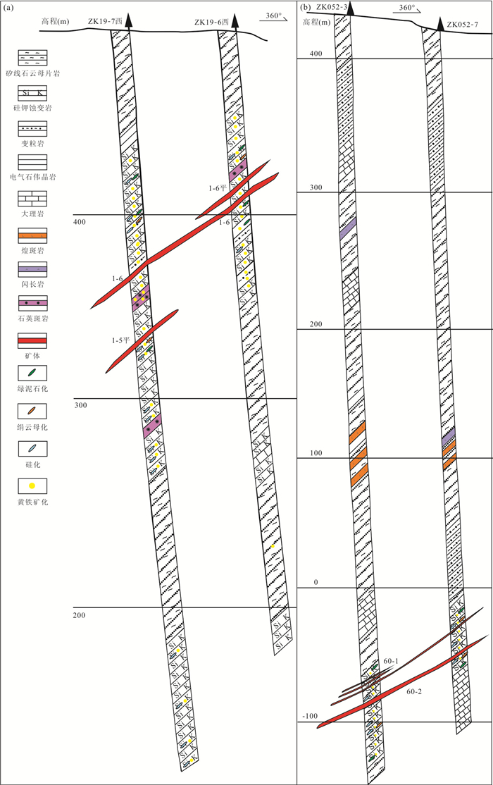
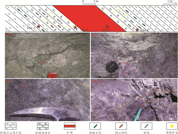
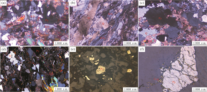
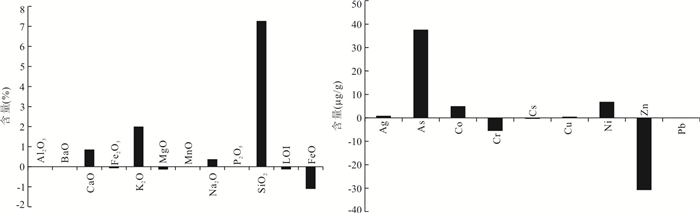
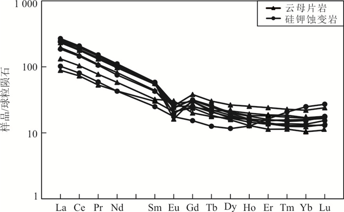
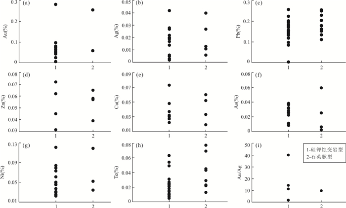
In order to clarify the genetic relationship between gold precipitation and silicic,K-feldspar alterations,silicic-potassic-altered and unaltered sillimanite/mica schist were selected for major and trace element analyses,while pyrites from quartz vein type and altered-rock type ore were selected for electron microprobe analyses. With Al2O3 chosen as inactive components,the mass balance calculations show that CaO,K2O,Na2O,SiO2,Ag,As,Co,Cu and Ni are brought in,contrary to FeO,Cr and Zn. Pyrites from altered-rock type ore and quartz vein type ore show the characteristics of depleted S and enriched Fe. The value of Au/Ag of pyrites is greater than 0.5,and the value of Fe/(S+As) ranges from 0.857 to 0.896. Pyrites are of hydrothermal origin and have formed in the medium-shallow depth and medium temperature environment. During the process of silicic and K-feldspar alterations,sulfur components are lost from hydrotherm. The decrease of sulfur activity destroys the stability of the gold-sulfur complex and leads to gold precipitation.
In order to clarify the genetic relationship between gold precipitation and silicic,K-feldspar alterations,silicic-potassic-altered and unaltered sillimanite/mica schist were selected for major and trace element analyses,while pyrites from quartz vein type and altered-rock type ore were selected for electron microprobe analyses. With Al2O3 chosen as inactive components,the mass balance calculations show that CaO,K2O,Na2O,SiO2,Ag,As,Co,Cu and Ni are brought in,contrary to FeO,Cr and Zn. Pyrites from altered-rock type ore and quartz vein type ore show the characteristics of depleted S and enriched Fe. The value of Au/Ag of pyrites is greater than 0.5,and the value of Fe/(S+As) ranges from 0.857 to 0.896. Pyrites are of hydrothermal origin and have formed in the medium-shallow depth and medium temperature environment. During the process of silicic and K-feldspar alterations,sulfur components are lost from hydrotherm. The decrease of sulfur activity destroys the stability of the gold-sulfur complex and leads to gold precipitation.
2020, 45(11): 3913-3933.
doi: 10.3799/dqkx.2020.220
Abstract:
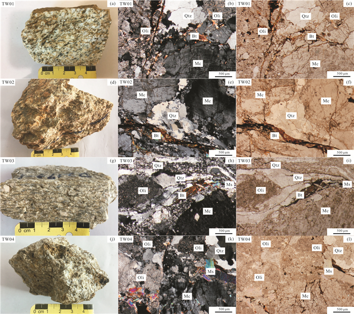
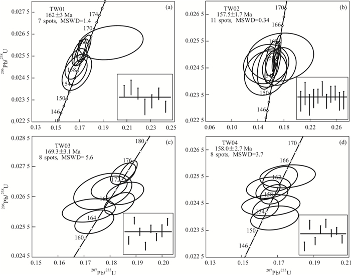
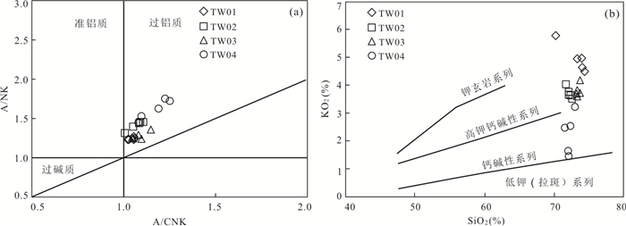
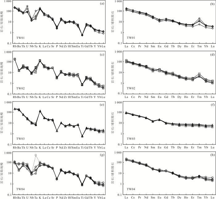
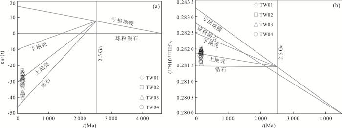
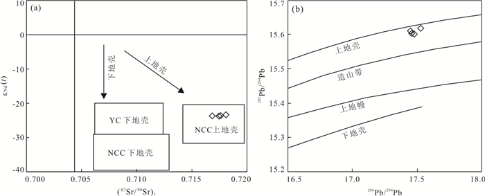
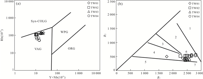
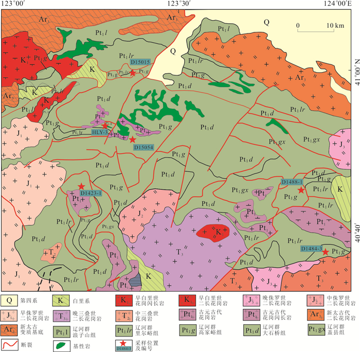
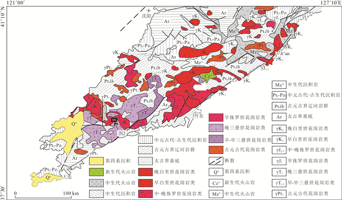
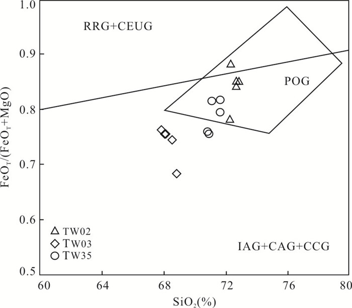
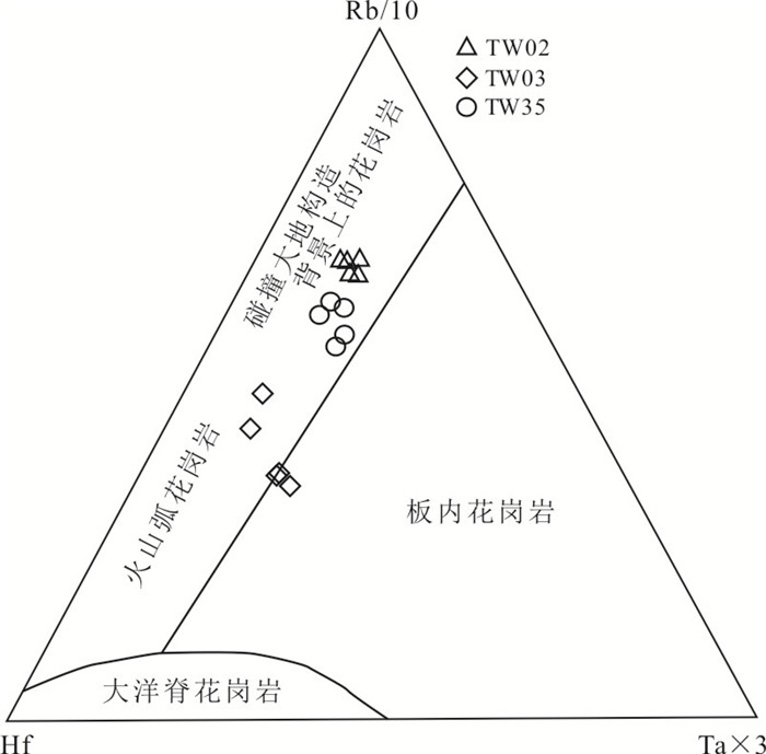
Jurassic granitic intrusions are widely exposed on the Liaodong Peninsula on the northeastern margin of the North China craton. The Wulong granitic pluton in the Dandong area is the wall rock of the Wulong gold deposit,which contains residues of Paleoproterozoic Liaohe Group metamorphic rocks and Paleoproterozoic intrusive rocks,with fragmentation and mylonitization developed locally. In this paper,the Wulong pluton is studied in detail,revealing that it is an assemblage of acid intrusive rocks containing biotite monzonitic granite,two-mica monzonitic granite,biotite syenite granite and granodiorite. According to zircon SHRIMP U-Pb isotope dating,the crystallization ages of these four rock types are 162±3 Ma,169.3±3.1 Ma,157.5±1.7 Ma and 158.0±2.7 Ma,respectively,or Middle-Late Jurassic. The geochemistry of the rocks shows that the Wulong pluton belongs to the calc-alkaline to high-K calc-alkaline,peraluminous and mesothermal granitic magma series,with enrichments in large ion lithophile elements (LILE) such as Rb,Th,U and K and depletions in high field strength elements (HFSE) such as Nb,Ta,P,and Ti. The εHf(t) values range from -39.7 to -22.9,and the tDM2 values are between 3 711 Ma and 2 653 Ma. The εNd(t) values vary from -23.8 to -20.2,and the tDM2 values are between 2 782 Ma and 2 487 Ma. These results show that the magma source is Archean to Paleoproterozoic crustal materials. Combining this information with Pb isotopes and the microstructural characteristics of quartz,feldspar and mica,it is believed that the large-scale Jurassic Wulong pluton on the Liaodong Peninsula is S-type granite,which recrystallized from Paleoproterozoic granites and Liaohe Group rocks in-situ in the upper crust affected by Late Jurassic (ca. 160 Ma) crustal remelting. The pluton was formed in a compressional orogenic tectonic setting influenced by the subduction of the Paleo-Pacific plate during the Middle-Late Jurassic.
Jurassic granitic intrusions are widely exposed on the Liaodong Peninsula on the northeastern margin of the North China craton. The Wulong granitic pluton in the Dandong area is the wall rock of the Wulong gold deposit,which contains residues of Paleoproterozoic Liaohe Group metamorphic rocks and Paleoproterozoic intrusive rocks,with fragmentation and mylonitization developed locally. In this paper,the Wulong pluton is studied in detail,revealing that it is an assemblage of acid intrusive rocks containing biotite monzonitic granite,two-mica monzonitic granite,biotite syenite granite and granodiorite. According to zircon SHRIMP U-Pb isotope dating,the crystallization ages of these four rock types are 162±3 Ma,169.3±3.1 Ma,157.5±1.7 Ma and 158.0±2.7 Ma,respectively,or Middle-Late Jurassic. The geochemistry of the rocks shows that the Wulong pluton belongs to the calc-alkaline to high-K calc-alkaline,peraluminous and mesothermal granitic magma series,with enrichments in large ion lithophile elements (LILE) such as Rb,Th,U and K and depletions in high field strength elements (HFSE) such as Nb,Ta,P,and Ti. The εHf(t) values range from -39.7 to -22.9,and the tDM2 values are between 3 711 Ma and 2 653 Ma. The εNd(t) values vary from -23.8 to -20.2,and the tDM2 values are between 2 782 Ma and 2 487 Ma. These results show that the magma source is Archean to Paleoproterozoic crustal materials. Combining this information with Pb isotopes and the microstructural characteristics of quartz,feldspar and mica,it is believed that the large-scale Jurassic Wulong pluton on the Liaodong Peninsula is S-type granite,which recrystallized from Paleoproterozoic granites and Liaohe Group rocks in-situ in the upper crust affected by Late Jurassic (ca. 160 Ma) crustal remelting. The pluton was formed in a compressional orogenic tectonic setting influenced by the subduction of the Paleo-Pacific plate during the Middle-Late Jurassic.

2020, 45(11): 3934-3949.
doi: 10.3799/dqkx.2020.222
Abstract:
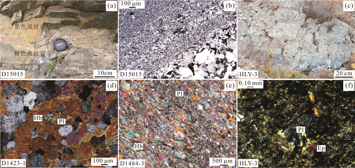
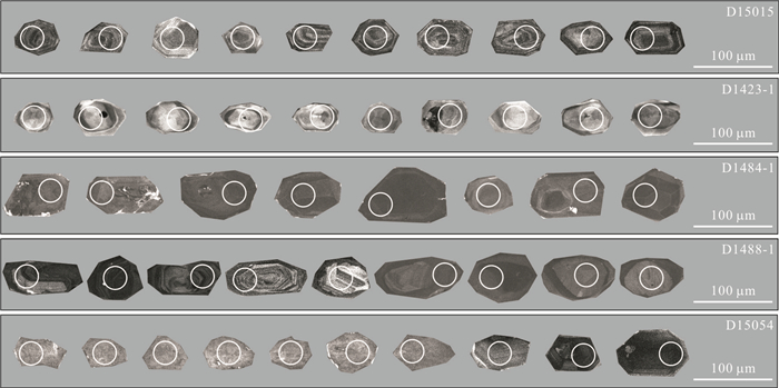
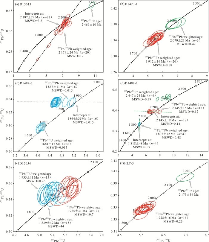
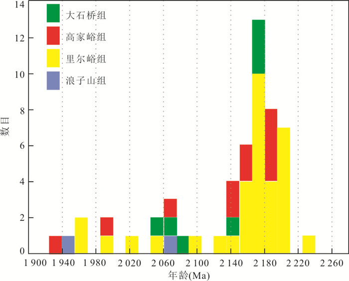
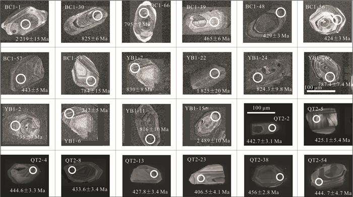
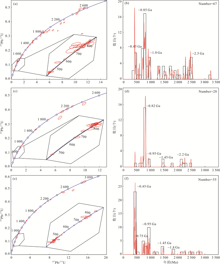
There are a large number of meta-sedimentary-volcanic strata in the Paleoproterozoic Liaoji belt between Longgang block and Langlin block,which is called Liaohe Group. There has been a debate on the sedimentary time of the Liaohe Group and the relationship among its inner groups. In order to solve these problems,the zircon U-Pb LA-ICP-MS geochronology of the volcanic rocks from the Gaojiayu Formation in the eastern Liaoning Province is studied. The dating results show that the magmatic activities of the Gaojiayu Formation can be divided into four stages:2 179-2 145 Ma,2 079 Ma,1 985 Ma and 1 928 Ma. Combining with the published chronological data,the volcanic activities in the Liaohe Group are mainly concentrated in three stages:the early magmatic activity in the first stage (2 210-2 140 Ma) is mainly acid volcanic rock,showing bimodal volcanic rock assemblage in the late stage; the second stage (2 100-2 050 Ma) magmatism is dominated by basic magmatism; the third stage (2 000-1 960 Ma) magmatism also shows bimodal volcanic rock assemblage. The sedimentary time of the Liaohe Group is limited to 2 229-1 928 Ma by the age of the volcanic rocks,and the deposition lasts at least 300 Ma. The chronological results show the ages of the of volcanic rocks in the Langzishan Formation,Lieryu Formation,Gaojiayu Formation and Dashiqiao Formation of Liaohe Group are alternant,and there is no regular upper-lower orderly relationship. In combination with the fact that the formations of Liaohe Group in the field mostly contact in the form of ductile shear zone,it is considered that the rock groups of Liaohe Group are not orderly sedimentary from the bottom to the top,but "disordered as a whole and orderly as a part".
There are a large number of meta-sedimentary-volcanic strata in the Paleoproterozoic Liaoji belt between Longgang block and Langlin block,which is called Liaohe Group. There has been a debate on the sedimentary time of the Liaohe Group and the relationship among its inner groups. In order to solve these problems,the zircon U-Pb LA-ICP-MS geochronology of the volcanic rocks from the Gaojiayu Formation in the eastern Liaoning Province is studied. The dating results show that the magmatic activities of the Gaojiayu Formation can be divided into four stages:2 179-2 145 Ma,2 079 Ma,1 985 Ma and 1 928 Ma. Combining with the published chronological data,the volcanic activities in the Liaohe Group are mainly concentrated in three stages:the early magmatic activity in the first stage (2 210-2 140 Ma) is mainly acid volcanic rock,showing bimodal volcanic rock assemblage in the late stage; the second stage (2 100-2 050 Ma) magmatism is dominated by basic magmatism; the third stage (2 000-1 960 Ma) magmatism also shows bimodal volcanic rock assemblage. The sedimentary time of the Liaohe Group is limited to 2 229-1 928 Ma by the age of the volcanic rocks,and the deposition lasts at least 300 Ma. The chronological results show the ages of the of volcanic rocks in the Langzishan Formation,Lieryu Formation,Gaojiayu Formation and Dashiqiao Formation of Liaohe Group are alternant,and there is no regular upper-lower orderly relationship. In combination with the fact that the formations of Liaohe Group in the field mostly contact in the form of ductile shear zone,it is considered that the rock groups of Liaohe Group are not orderly sedimentary from the bottom to the top,but "disordered as a whole and orderly as a part".
2020, 45(11): 3950-3961.
doi: 10.3799/dqkx.2020.201
Abstract:
In order to determine the petrogenesis and tectonic setting of the Early Cretaceous biotite monzodiorite in Liaodong Peninsula,the lithology identification,zircon LA-ICP-MS U-Pb dating,major and trace elements,and Hf isotope data for the Huangling rock mass from southwest of Xiuyan are presented in this paper. The LA-ICP-MS U-Pb ages of the Huangling pluton of the monzodiorite is 127.4±1.9 Ma. The results of elemental and isotope geochemistry show that the Huangling monzodiorite belongs to high-K calc-alkaline series,and enriched in LREE and LILE (Rb,Zr,K),but depleted in HREE and HFSE (Nb,P,Ti) with positive Eu anomalies. The zircon εHf(t) values of the pluton range from -20.1 to -18.0,TDM2 ranges between 2 450 and 2 316 Ma,suggesting that the monzodiorite was mainly derived from the partial melting of the Paleoproterozoic crustal material. Combined with regional tectonic evolution,it is proposed that the Huangling monzodiorite diagenetic tectonic environment is the active continental margin,maybe formed in the extension tectonic environment,which is closely associated with the subduction of the Paleo-Pacific plate.
In order to determine the petrogenesis and tectonic setting of the Early Cretaceous biotite monzodiorite in Liaodong Peninsula,the lithology identification,zircon LA-ICP-MS U-Pb dating,major and trace elements,and Hf isotope data for the Huangling rock mass from southwest of Xiuyan are presented in this paper. The LA-ICP-MS U-Pb ages of the Huangling pluton of the monzodiorite is 127.4±1.9 Ma. The results of elemental and isotope geochemistry show that the Huangling monzodiorite belongs to high-K calc-alkaline series,and enriched in LREE and LILE (Rb,Zr,K),but depleted in HREE and HFSE (Nb,P,Ti) with positive Eu anomalies. The zircon εHf(t) values of the pluton range from -20.1 to -18.0,TDM2 ranges between 2 450 and 2 316 Ma,suggesting that the monzodiorite was mainly derived from the partial melting of the Paleoproterozoic crustal material. Combined with regional tectonic evolution,it is proposed that the Huangling monzodiorite diagenetic tectonic environment is the active continental margin,maybe formed in the extension tectonic environment,which is closely associated with the subduction of the Paleo-Pacific plate.

2020, 45(11): 3962-3981.
doi: 10.3799/dqkx.2020.293
Abstract:
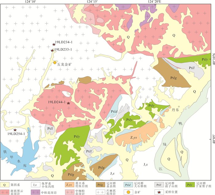
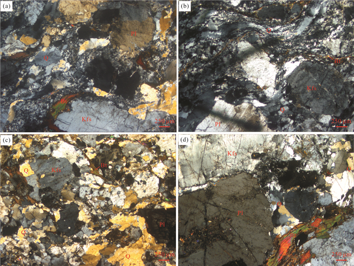
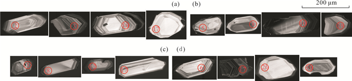
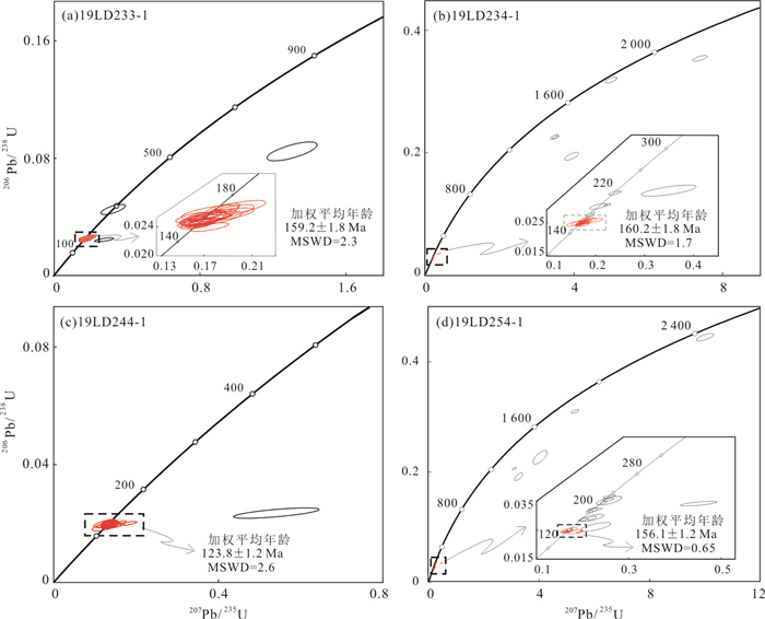
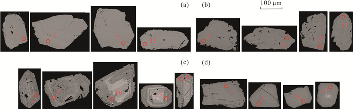
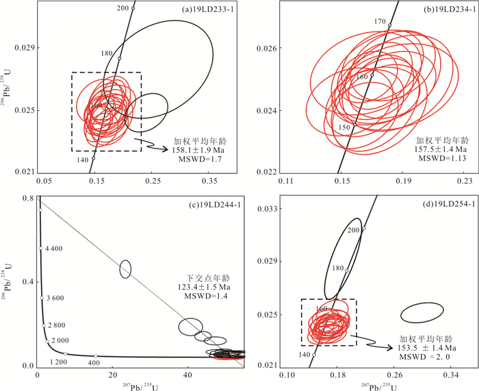
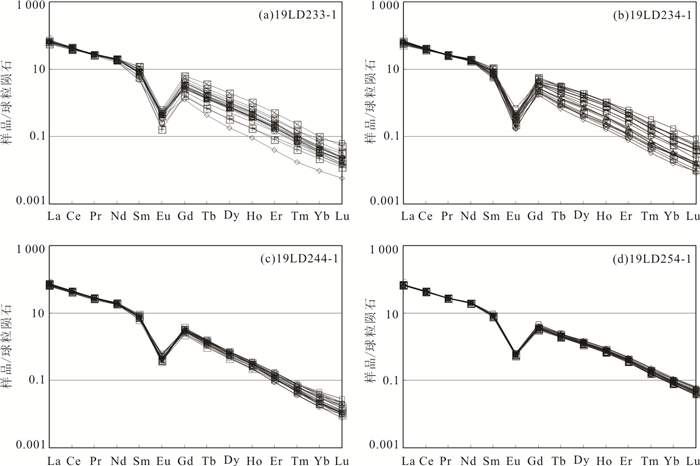
The Mesozoic magmatic activities extensively developed in East Liaoning Province accompanied by large-scale gold mineralization. Wulong gold deposit is a representative largest quartz-vein type gold deposit,and the gold ore bodies mainly hosted in Jurassic gneiss biotite granite and Early Cretaceous granodiorite. Therefore,Mesozoic magmatism has a significant genetic relation with the gold mineralization. In this paper,it presents zircon and monazite U-Pb dating of gneiss granite and Sanguliu rock mass in Wulong gold ore-concentrated district to constrain their emplacement ages. The gneiss granite is dominated by biotite monzogranite,the minerals of which show strong ductile deformation and are oriented. Their zircon U-Pb ages are 159.2±1.8 Ma,160.2±1.8 Ma,and 156.1±1.2 Ma,respectively. Zircons from Sanguliu biotite monzogranite yield a U-Pb age of 123.8±1.2 Ma. Mineralogical characteristics and chemical compositions of monazites from four granitic samples suggest a magmatic origin. New LA-ICP-MS dating of monazites from three gneiss granite samples yielded U-Pb ages of 158.1±1.9 Ma,157.5±1.4 Ma,and 153.5±1.4 Ma,respectively,and 123.4±1.5 Ma for Sanguliu biotite monzogranite. Monazite ages of Late Jurassic gneiss granite are 1.1-2.7 Ma younger than their zircon ages,two of which have high cooling rate of 55.56℃/Ma and 57.69℃/Ma,suggesting a rapid cooling process and crustal uplift. Both zircon and monazite U-Pb ages indicate that the gneiss granite and Sanguliu rock mass formed during Late Jurassic and Early Cretaceous,respectively. In combination with the available data,Wulong gold ore-concentrated district mainly developed Late Jurassic and Early Cretaceous magmatic activities,which were closely related to the subduction of Paleo-Pacific plate to Eurasia continent,accompanied by Early Cretaceous gold mineralization.
The Mesozoic magmatic activities extensively developed in East Liaoning Province accompanied by large-scale gold mineralization. Wulong gold deposit is a representative largest quartz-vein type gold deposit,and the gold ore bodies mainly hosted in Jurassic gneiss biotite granite and Early Cretaceous granodiorite. Therefore,Mesozoic magmatism has a significant genetic relation with the gold mineralization. In this paper,it presents zircon and monazite U-Pb dating of gneiss granite and Sanguliu rock mass in Wulong gold ore-concentrated district to constrain their emplacement ages. The gneiss granite is dominated by biotite monzogranite,the minerals of which show strong ductile deformation and are oriented. Their zircon U-Pb ages are 159.2±1.8 Ma,160.2±1.8 Ma,and 156.1±1.2 Ma,respectively. Zircons from Sanguliu biotite monzogranite yield a U-Pb age of 123.8±1.2 Ma. Mineralogical characteristics and chemical compositions of monazites from four granitic samples suggest a magmatic origin. New LA-ICP-MS dating of monazites from three gneiss granite samples yielded U-Pb ages of 158.1±1.9 Ma,157.5±1.4 Ma,and 153.5±1.4 Ma,respectively,and 123.4±1.5 Ma for Sanguliu biotite monzogranite. Monazite ages of Late Jurassic gneiss granite are 1.1-2.7 Ma younger than their zircon ages,two of which have high cooling rate of 55.56℃/Ma and 57.69℃/Ma,suggesting a rapid cooling process and crustal uplift. Both zircon and monazite U-Pb ages indicate that the gneiss granite and Sanguliu rock mass formed during Late Jurassic and Early Cretaceous,respectively. In combination with the available data,Wulong gold ore-concentrated district mainly developed Late Jurassic and Early Cretaceous magmatic activities,which were closely related to the subduction of Paleo-Pacific plate to Eurasia continent,accompanied by Early Cretaceous gold mineralization.
2020, 45(11): 3982-3997.
doi: 10.3799/dqkx.2020.217
Abstract:
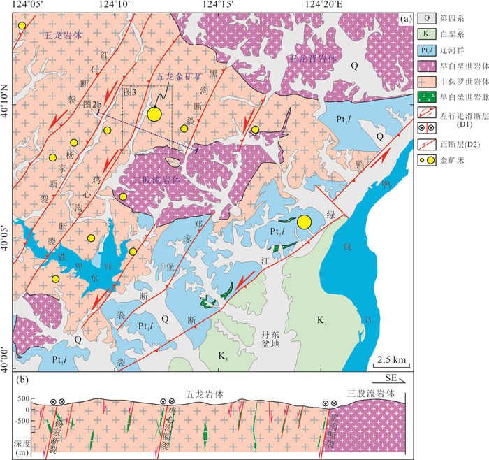
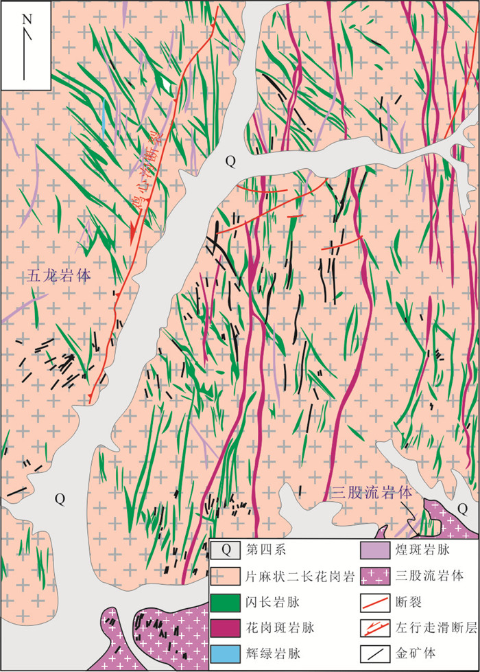
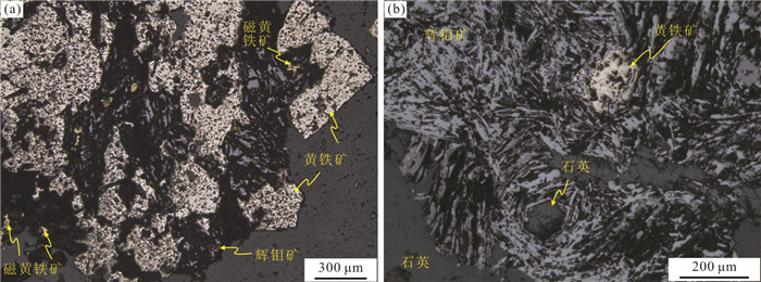
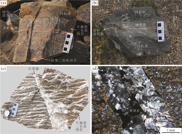
The Wulong gold deposit is one of the most representative quartz-vein gold deposits in the Liaodong district in the NE China. The ore bodies and dikes are controlled by faults. The geometry,kinematics and kinetics characteristics of the ore-bearing structures indicate that the structural framework in the Wulong gold district is composed of the N-S tensile fracture,several NE-striking sinistral and NW-striking dextral conjugate faults and associated conjugate riedal fractures caused by the nearly N-S compression at the beginning of the Early Cretaceous. The diorites,Sanguliu pluton and Wulongbei pluton intruded into the pre-existing structures and NE-striking normal faults accompanied with the NW-SE extension during the Early Cretaceous. Hydrothermal fluid exsolution from the Early Cretaceous magmas migrated into the residual space in the fractures which were intruded by diorite. The dextral shear deformation led to the break of the quartz. The fractures infilled by granite dikes and quartz vines reactivated and the ore-forming fluids were characterized by vertical transport and lateral replacement in these fractures. The fluids infilled into the fractures of the broken quartz and replaced the Early Cretaceous dikes and gneissic monzonite granite. Therefore,the auriferous quartz veins share the similar space with the previous quartz and dikes. Kinetic characteristics of the ore-bearing structures indicate that the north of the NE-striking faults has the exploration potential and has a similar regularity for lateral trending of orebodies in the Sanshandao gold belt,Jiaodong district. In the Wulong gold district,the exploration potential of NE-striking faults is better than in the NW-striking faults and the tensile fractures in the footwall blocks of NE-striking faults are the advantageous space for searching for the concealed orebodies. This study first defines a molybdenite Re-Os isotopic model age of 125 ±2.1 Ma for the molybdenite-pyrite-pyrrhotite-quartz stage which represents the major ore-forming stage of the Wulong gold deposit. The Re concentrations of the molybdenite is 12.8×10⁻⁶,suggesting that ore-forming material contained a mixture of crustal and mantle components. The comparison of previous studies indicate that both of the molybdenum and gold mineralization are related with the intense crust-mantle magma activity in NE China. In comparison with the metallogenic series in the Jiaodong district,both of the Liaodong and Jiaodong have two stages of molybdenum mineralization. Especially,the late of the Early Cretaceous molybdenum mineralization could be one of the clues for gold prespecting in the Liaodong district.
The Wulong gold deposit is one of the most representative quartz-vein gold deposits in the Liaodong district in the NE China. The ore bodies and dikes are controlled by faults. The geometry,kinematics and kinetics characteristics of the ore-bearing structures indicate that the structural framework in the Wulong gold district is composed of the N-S tensile fracture,several NE-striking sinistral and NW-striking dextral conjugate faults and associated conjugate riedal fractures caused by the nearly N-S compression at the beginning of the Early Cretaceous. The diorites,Sanguliu pluton and Wulongbei pluton intruded into the pre-existing structures and NE-striking normal faults accompanied with the NW-SE extension during the Early Cretaceous. Hydrothermal fluid exsolution from the Early Cretaceous magmas migrated into the residual space in the fractures which were intruded by diorite. The dextral shear deformation led to the break of the quartz. The fractures infilled by granite dikes and quartz vines reactivated and the ore-forming fluids were characterized by vertical transport and lateral replacement in these fractures. The fluids infilled into the fractures of the broken quartz and replaced the Early Cretaceous dikes and gneissic monzonite granite. Therefore,the auriferous quartz veins share the similar space with the previous quartz and dikes. Kinetic characteristics of the ore-bearing structures indicate that the north of the NE-striking faults has the exploration potential and has a similar regularity for lateral trending of orebodies in the Sanshandao gold belt,Jiaodong district. In the Wulong gold district,the exploration potential of NE-striking faults is better than in the NW-striking faults and the tensile fractures in the footwall blocks of NE-striking faults are the advantageous space for searching for the concealed orebodies. This study first defines a molybdenite Re-Os isotopic model age of 125 ±2.1 Ma for the molybdenite-pyrite-pyrrhotite-quartz stage which represents the major ore-forming stage of the Wulong gold deposit. The Re concentrations of the molybdenite is 12.8×10⁻⁶,suggesting that ore-forming material contained a mixture of crustal and mantle components. The comparison of previous studies indicate that both of the molybdenum and gold mineralization are related with the intense crust-mantle magma activity in NE China. In comparison with the metallogenic series in the Jiaodong district,both of the Liaodong and Jiaodong have two stages of molybdenum mineralization. Especially,the late of the Early Cretaceous molybdenum mineralization could be one of the clues for gold prespecting in the Liaodong district.

2020, 45(11): 3998-4013.
doi: 10.3799/dqkx.2020.292
Abstract:
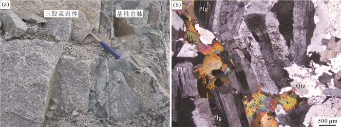
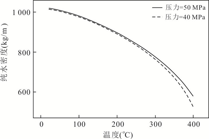
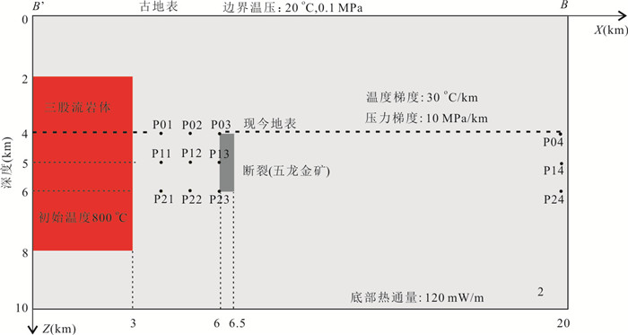
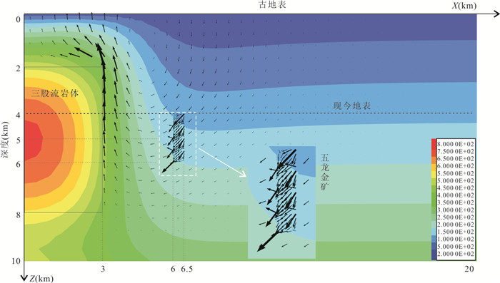
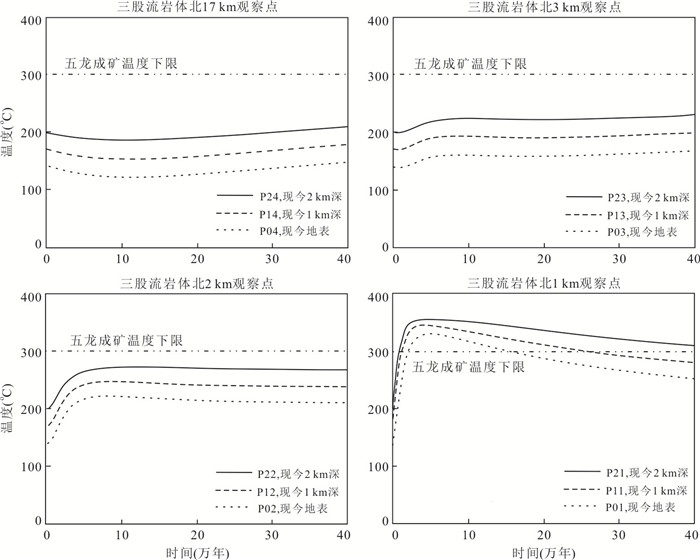
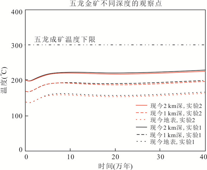
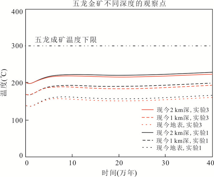
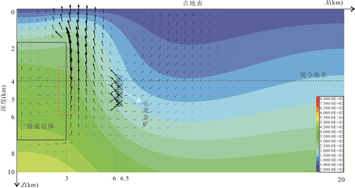
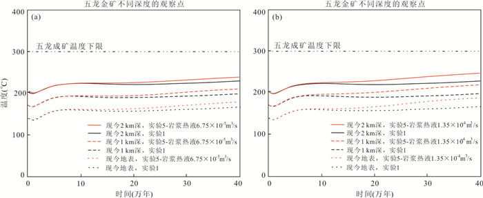
The Wulong gold deposit located in Liaoning Province is a typical vein-type gold deposit in the eastern part of the North China craton,but how this large-scale gold deposit formed remains controversial. This deposit was interpreted to be genetically related to the Sanguliu granite because they are spatially close and have close chronological ages and the mineralizing fluids have a magmatic-hydrothermal origin. There is no sufficient evidence supporting that the Sanguliu granite provided the gold-bearing magmatic-hydrothermal fluids required for forming the Wulong deposit,so did the former provide sufficient energy for the latter? In order to answer this question,numerical modeling of heat-driven convection of meteoric water and magmatic-hydrothermal fluids released by the Sanguliu granite was built based on its geochemical and geophysical characteristics to simulate the evolution of fluid flow and temperature after emplacement of the granite. Numerical results indicate that the temperatures within 1 km of the Sanguliu granite were elevated to over 300℃ for hundreds of thousands of years. This long high temperature filed favors formation of magmatic-hydrothermal deposits. In contrast,the position of the Wulong deposit received insignificant energy from the Sanguliu granite. If magmatic-hydrothermal fluids were released from the Sanguliu granite,those magmatic-hydrothermal fluids should have caused alteration and minerlization at the granite margin and the contact between the granite and its wallrock. However,these phenomena have not been identified in the field. Therefore,there is probably no genetic relationship between the large-scale Wulong deposit and the Sanguliu granite,and further investigations are needed to identify the source for Au-mineralizing fluids.
The Wulong gold deposit located in Liaoning Province is a typical vein-type gold deposit in the eastern part of the North China craton,but how this large-scale gold deposit formed remains controversial. This deposit was interpreted to be genetically related to the Sanguliu granite because they are spatially close and have close chronological ages and the mineralizing fluids have a magmatic-hydrothermal origin. There is no sufficient evidence supporting that the Sanguliu granite provided the gold-bearing magmatic-hydrothermal fluids required for forming the Wulong deposit,so did the former provide sufficient energy for the latter? In order to answer this question,numerical modeling of heat-driven convection of meteoric water and magmatic-hydrothermal fluids released by the Sanguliu granite was built based on its geochemical and geophysical characteristics to simulate the evolution of fluid flow and temperature after emplacement of the granite. Numerical results indicate that the temperatures within 1 km of the Sanguliu granite were elevated to over 300℃ for hundreds of thousands of years. This long high temperature filed favors formation of magmatic-hydrothermal deposits. In contrast,the position of the Wulong deposit received insignificant energy from the Sanguliu granite. If magmatic-hydrothermal fluids were released from the Sanguliu granite,those magmatic-hydrothermal fluids should have caused alteration and minerlization at the granite margin and the contact between the granite and its wallrock. However,these phenomena have not been identified in the field. Therefore,there is probably no genetic relationship between the large-scale Wulong deposit and the Sanguliu granite,and further investigations are needed to identify the source for Au-mineralizing fluids.


2020, 45(11): 4014-4026.
doi: 10.3799/dqkx.2020.312
Abstract:
As shallow responses to the destruction of North China craton,metamorphic core complex structures,which are widely distributed in Liaodong Peninsula,are of great significance to study the regional tectonic evolution. Xinfang metamorphic core complex is a newly discovered extensional unit with typical 3-layers structure. The hanging wall includes weakly deformed sedimentary strata from Neoproterozoic to Paleozoic and Zhuanghe faulted basin formed in Early Cretaceous. The footwall includes Archean metamorphic rocks and Mesozoic syntectonic granitic intrusive rocks. The contact relationship between the hanging wall and footwall is a detachment fault zone.The macroscopic characteristics in the field and microstructural characteristics under the microscope are obvious,indicating that the hanging wall has the kinematical characteristic from SEE to NWW,which is consistent with the movement direction of the Pacific plate during the early and middle period of Early Cretaceous. Using the method of LA-ICP-MS U-Pb isotope testing on zircons and testing of major,rare earth and trace elements,the forming age of the Xinfang metamorphic core complex is approximately limited to the early stage of Early Cretaceous(123-125 Ma),and the complex is regarded as a product of the destruction of the North China craton. The metamorphic core complex controls the formation of Xinfang large-scale gold deposit,and the research on the complex is of great significance under the situation that present complexes in Liaodong Peninsula have weak relationship with gold mineralization.
As shallow responses to the destruction of North China craton,metamorphic core complex structures,which are widely distributed in Liaodong Peninsula,are of great significance to study the regional tectonic evolution. Xinfang metamorphic core complex is a newly discovered extensional unit with typical 3-layers structure. The hanging wall includes weakly deformed sedimentary strata from Neoproterozoic to Paleozoic and Zhuanghe faulted basin formed in Early Cretaceous. The footwall includes Archean metamorphic rocks and Mesozoic syntectonic granitic intrusive rocks. The contact relationship between the hanging wall and footwall is a detachment fault zone.The macroscopic characteristics in the field and microstructural characteristics under the microscope are obvious,indicating that the hanging wall has the kinematical characteristic from SEE to NWW,which is consistent with the movement direction of the Pacific plate during the early and middle period of Early Cretaceous. Using the method of LA-ICP-MS U-Pb isotope testing on zircons and testing of major,rare earth and trace elements,the forming age of the Xinfang metamorphic core complex is approximately limited to the early stage of Early Cretaceous(123-125 Ma),and the complex is regarded as a product of the destruction of the North China craton. The metamorphic core complex controls the formation of Xinfang large-scale gold deposit,and the research on the complex is of great significance under the situation that present complexes in Liaodong Peninsula have weak relationship with gold mineralization.
2020, 45(11): 4026-4026.
Abstract:
2020, 45(11): 4027-4037.
doi: 10.3799/dqkx.2020.283
Abstract:
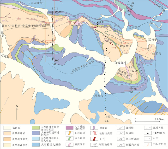
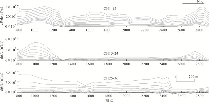
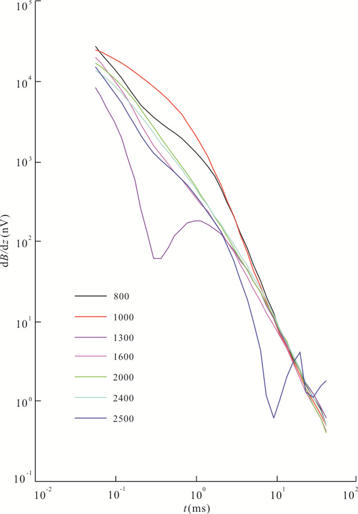
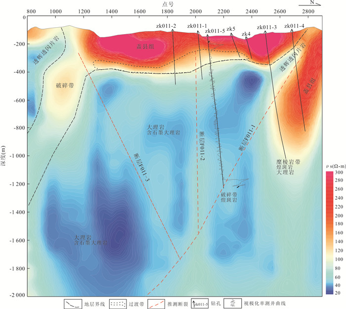
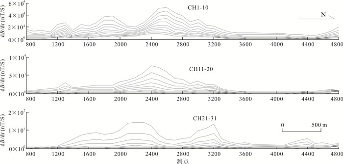
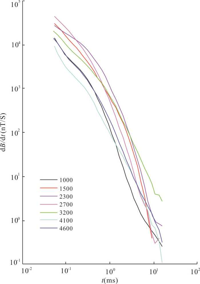
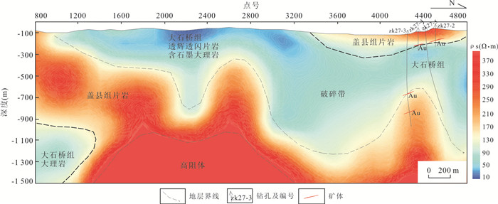
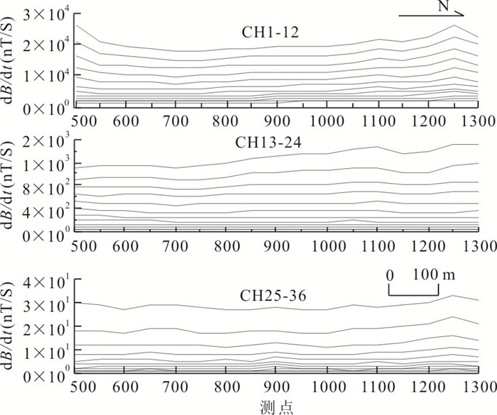
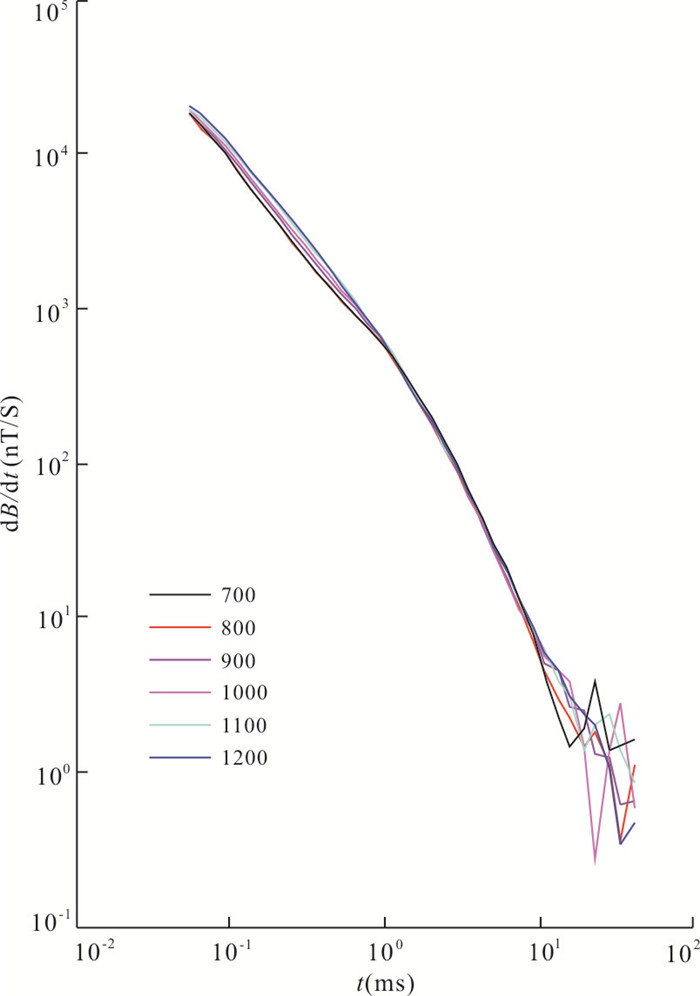
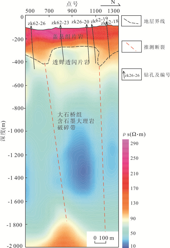
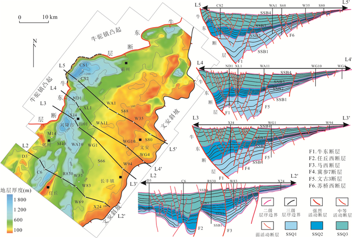
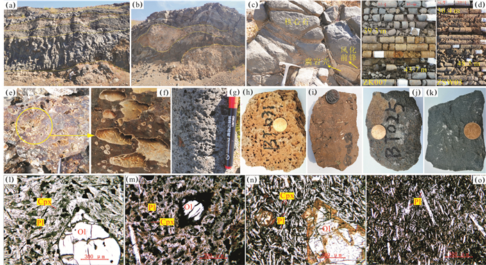
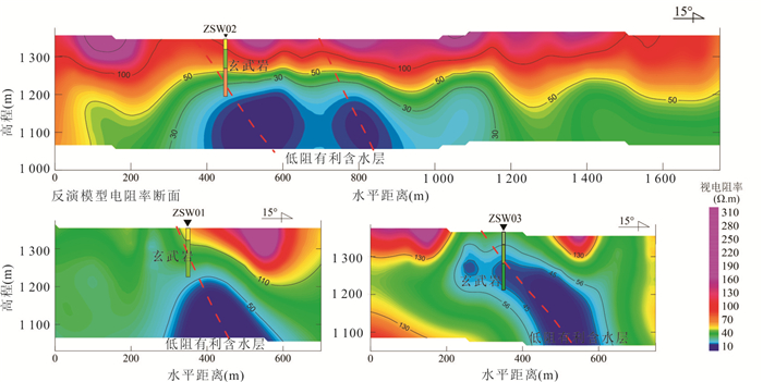
The Baiyun gold deposit in the Liaodong Province,NE,North China craton (NCC),is a large-scale gold deposit with great potential for deep exploration. In order to find deep and peripheral ore in the Baiyun gold deposit,transient electromagnetic (TEM) method was applied to the exploration of strata and structures. Both fixed-loop and central-loop configurations were used in field data acquisition with a high-power transmitting system to ensure high data quality and long observation time. The local strata are mainly the third member of Dashiqiao Formation and Gaixian Formation. The third member of Dashiqiao Formation is of low resistivity in general,which is mainly caused by diopside diorite schist and graphite bearing marble. The main components of Gaixian Formation are schist and granulite,which are of middle to high resistivity. The results show that TEM method can detect the distribution of Gaixian Formation,Dashiqiao Formation,and the folds and faults within these formations. The inversion results of three TEM lines show that the western part of the Baiyun deposit has been greatly compressed,forming obvious nappe structure,while the eastern part of the Baiyun deposit is gentler in fold and weaker in compression. Exploration results show that TEM methods are useful geophysical tools in the study of ore bearing strata and ore control structures in Baiyun gold deposit area.
The Baiyun gold deposit in the Liaodong Province,NE,North China craton (NCC),is a large-scale gold deposit with great potential for deep exploration. In order to find deep and peripheral ore in the Baiyun gold deposit,transient electromagnetic (TEM) method was applied to the exploration of strata and structures. Both fixed-loop and central-loop configurations were used in field data acquisition with a high-power transmitting system to ensure high data quality and long observation time. The local strata are mainly the third member of Dashiqiao Formation and Gaixian Formation. The third member of Dashiqiao Formation is of low resistivity in general,which is mainly caused by diopside diorite schist and graphite bearing marble. The main components of Gaixian Formation are schist and granulite,which are of middle to high resistivity. The results show that TEM method can detect the distribution of Gaixian Formation,Dashiqiao Formation,and the folds and faults within these formations. The inversion results of three TEM lines show that the western part of the Baiyun deposit has been greatly compressed,forming obvious nappe structure,while the eastern part of the Baiyun deposit is gentler in fold and weaker in compression. Exploration results show that TEM methods are useful geophysical tools in the study of ore bearing strata and ore control structures in Baiyun gold deposit area.
2020, 45(11): 4038-4053.
doi: 10.3799/dqkx.2020.263
Abstract:
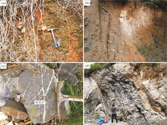
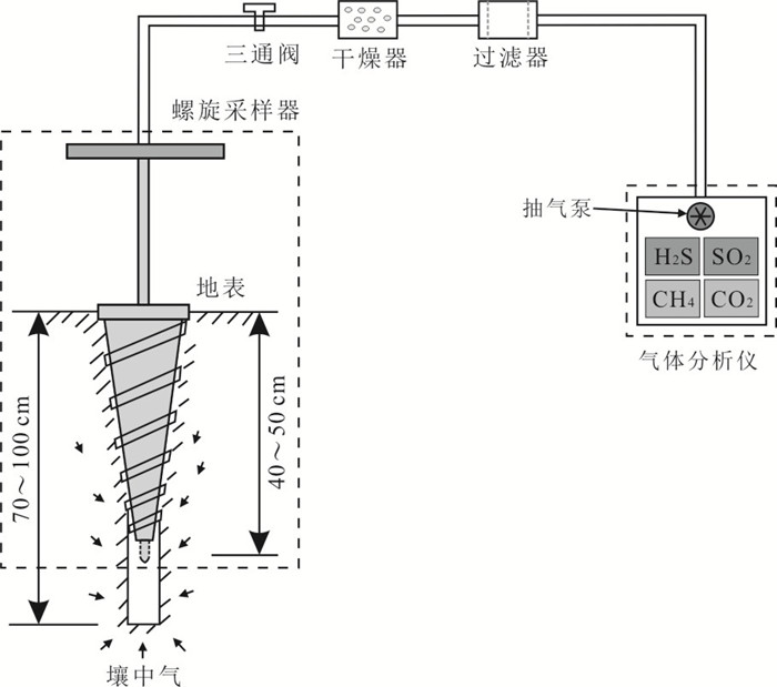
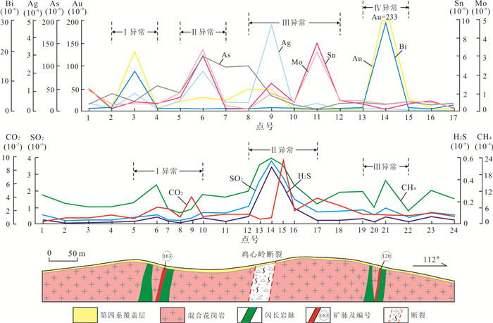
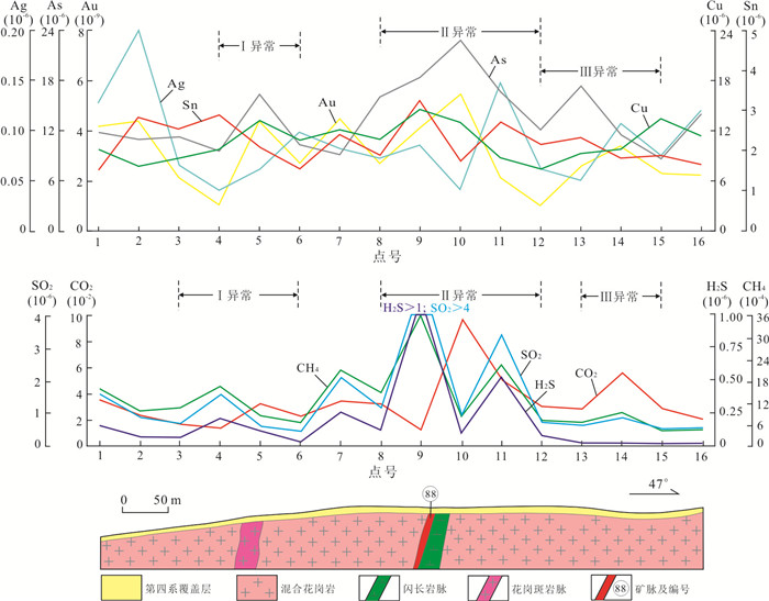
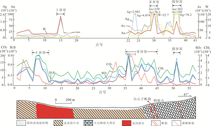
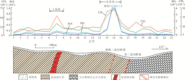
Gas can carry deep mineralization information migrated to the surface along the rock fissures and fault zones. Therefore, gas geochemical methods can be used to find hidden faults and ore bodies below the cover layer. Based on the Portable Multi-Component Gas Rapid Analyzer (PMGRA) geochemical method, exploratory experimental studies were carried out in Wulong gold mining area and Qingchengzi area, Liaodong area, and supplemented by corresponding soil geochemical surveys for comparison. The results show that the concentration of the gas in the abnormal area is very large, with the abnormal peaks of CO2 appearing before H2S, SO2 and CH4 in part of the gas anomaly area, along the structural dip direction. In the shallow covered area of Liaodong, both gas and soil geochemical surveys can reflect hidden structures and ore bodies. However, in the thicker covered area, gas geochemical surveys can more clearly reflect the faults and ore bodies, and are less affected by the type and thickness of the cover layer. The results of this test initially show the feasibility of PMGRA geochemical survey method in shallow covered area.
Gas can carry deep mineralization information migrated to the surface along the rock fissures and fault zones. Therefore, gas geochemical methods can be used to find hidden faults and ore bodies below the cover layer. Based on the Portable Multi-Component Gas Rapid Analyzer (PMGRA) geochemical method, exploratory experimental studies were carried out in Wulong gold mining area and Qingchengzi area, Liaodong area, and supplemented by corresponding soil geochemical surveys for comparison. The results show that the concentration of the gas in the abnormal area is very large, with the abnormal peaks of CO2 appearing before H2S, SO2 and CH4 in part of the gas anomaly area, along the structural dip direction. In the shallow covered area of Liaodong, both gas and soil geochemical surveys can reflect hidden structures and ore bodies. However, in the thicker covered area, gas geochemical surveys can more clearly reflect the faults and ore bodies, and are less affected by the type and thickness of the cover layer. The results of this test initially show the feasibility of PMGRA geochemical survey method in shallow covered area.
2020, 45(11): 4054-4071.
doi: 10.3799/dqkx.2020.998
Abstract:
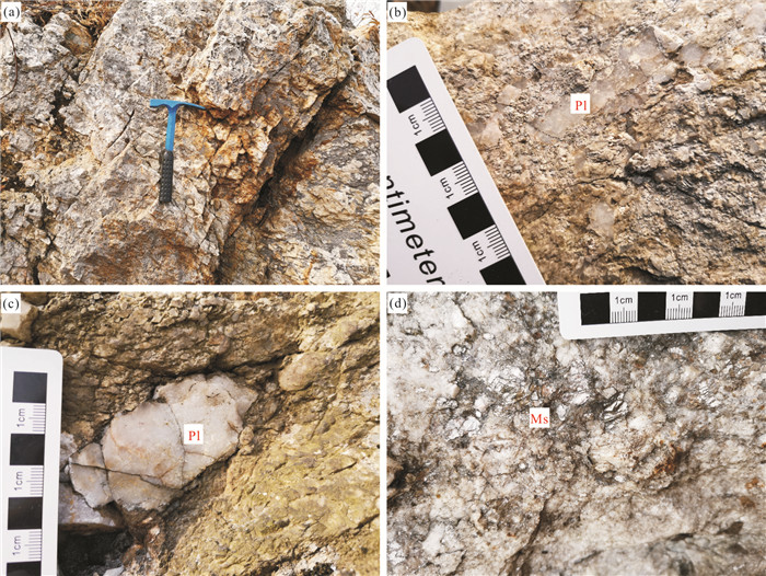
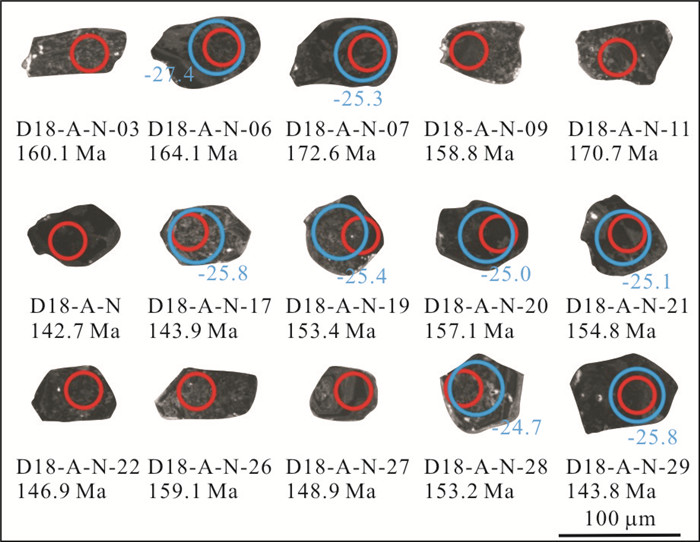
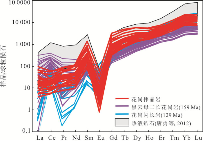
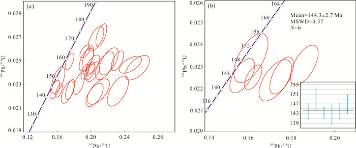
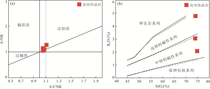
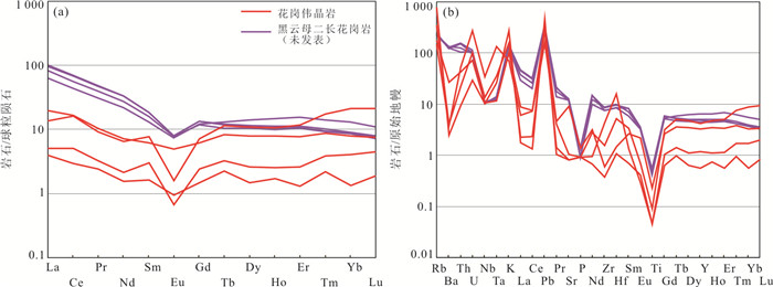
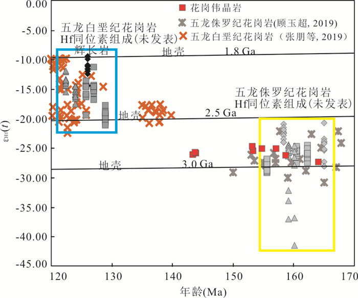
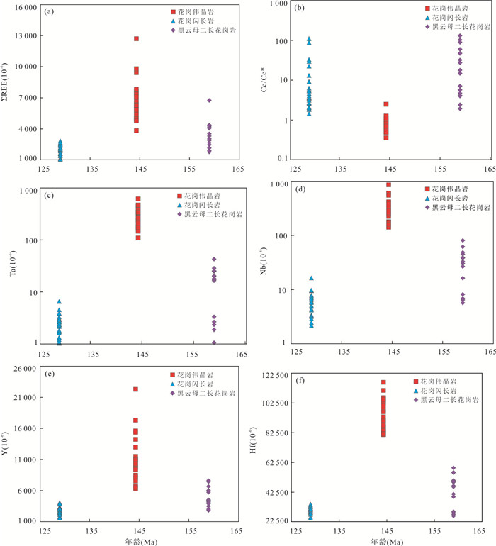
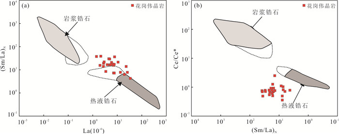
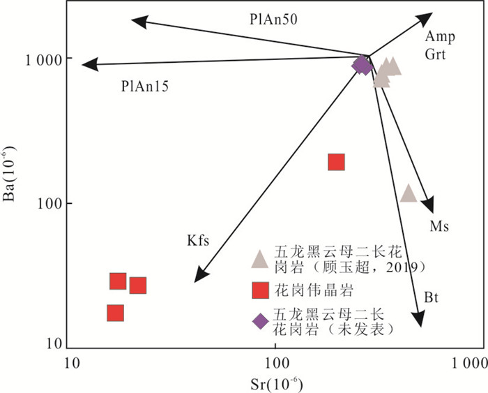
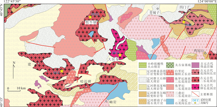
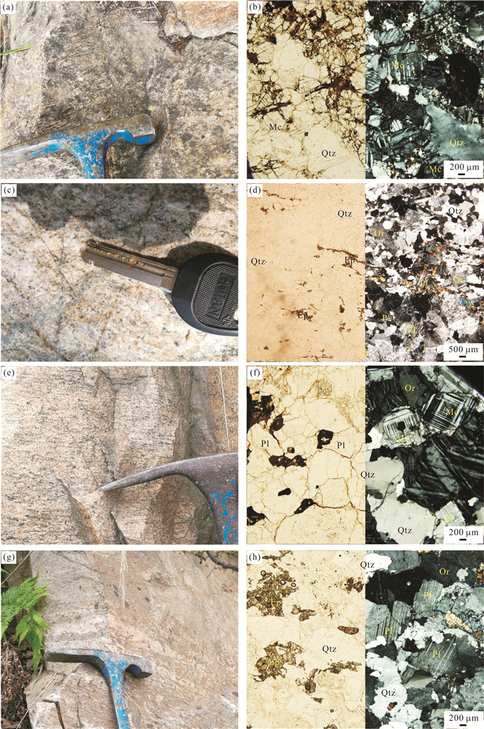
The early stage of Early Cretaceous magmatic activity in the Liaodong Peninsula was extremely rare and the research has been inadequate, which leads to the lack of direct evidence for constraints on the tectonic setting. Here, it presents new petrological, whole-rock geochemical, zircon U-Pb geochronological, cathodoluminescence (CL) imaging, trace element and Lu-Hf isotopic data for granitic pegmatite of the Sanguliu region, Liaodong Peninsula. Most of the zircon grains show very weak cathodoluminescence, with few oscillatory zoning, low Th/U ratios(< 0.1), and the zircon REEs are also markedly different from magmatic zircons, which is typical of hydrothermal zircon. Zircon U-Pb dating shows that the granitic pegmatite was formed at 144.3 ±2.7 Ma. The granitic pegmatite is characterized by enrichment in Si, Al and alkali, and depletion in Fe and Mg. In addition, the granitic pegmatite is enriched in lithophile elements and depleted in high-field strength elements, with REE tetrad effect. The zircon grains from the granitic pegmatite have εHf(t) values of -27.4 to -24.7, with two-stage Hf model ages ranging from 2.91 to 2.74 Ga, which is similar to the Wulong Middle-Late Jurassic granites. It can infer that Sanguliu granitic pegmatite may have genetic relationship with Wulong Middle-Late Jurassic granites, and Sanguliu granitic pegmatite may be originated from the hybrid of hydrothermal fluid and magma after the highly fractional crystallization of parental magma. By combining these findings with the previous research results, this study proposes that the early stage of Early Cretaceous magmation was formed at extension setting in the Liaodong Peninsula, which is related to the post-collision of the Mongol-Okhotsk Ocean and the back-arc basin of the Pacific plate subduction.
The early stage of Early Cretaceous magmatic activity in the Liaodong Peninsula was extremely rare and the research has been inadequate, which leads to the lack of direct evidence for constraints on the tectonic setting. Here, it presents new petrological, whole-rock geochemical, zircon U-Pb geochronological, cathodoluminescence (CL) imaging, trace element and Lu-Hf isotopic data for granitic pegmatite of the Sanguliu region, Liaodong Peninsula. Most of the zircon grains show very weak cathodoluminescence, with few oscillatory zoning, low Th/U ratios(< 0.1), and the zircon REEs are also markedly different from magmatic zircons, which is typical of hydrothermal zircon. Zircon U-Pb dating shows that the granitic pegmatite was formed at 144.3 ±2.7 Ma. The granitic pegmatite is characterized by enrichment in Si, Al and alkali, and depletion in Fe and Mg. In addition, the granitic pegmatite is enriched in lithophile elements and depleted in high-field strength elements, with REE tetrad effect. The zircon grains from the granitic pegmatite have εHf(t) values of -27.4 to -24.7, with two-stage Hf model ages ranging from 2.91 to 2.74 Ga, which is similar to the Wulong Middle-Late Jurassic granites. It can infer that Sanguliu granitic pegmatite may have genetic relationship with Wulong Middle-Late Jurassic granites, and Sanguliu granitic pegmatite may be originated from the hybrid of hydrothermal fluid and magma after the highly fractional crystallization of parental magma. By combining these findings with the previous research results, this study proposes that the early stage of Early Cretaceous magmation was formed at extension setting in the Liaodong Peninsula, which is related to the post-collision of the Mongol-Okhotsk Ocean and the back-arc basin of the Pacific plate subduction.
2020, 45(11): 4072-4090.
doi: 10.3799/dqkx.2020.218
Abstract:
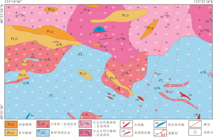
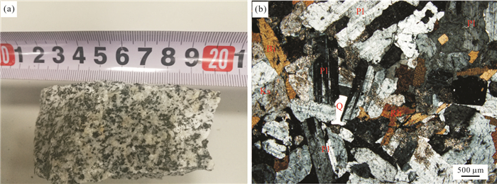
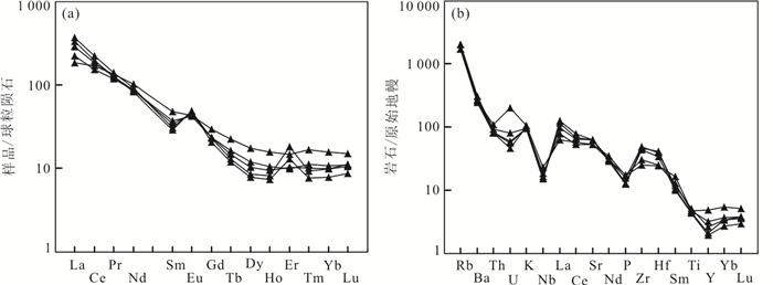
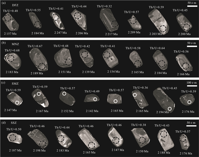
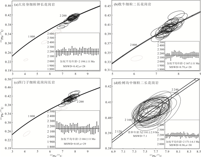
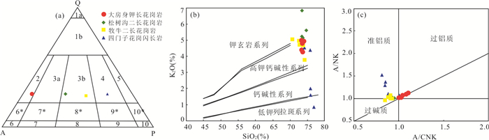
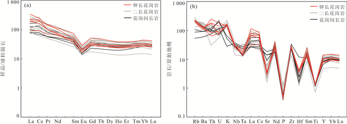
The Xiuyan region in Liaodong Peninsula is an ideal place for studying early evolution process of the Jiao-Liao-Ji orogenic belt, due to quantities of outcropped meta-sidimentary rocks and granitoids. A study of petrography, geochemistry and chronology is carried out on one K-feldspar granite, two mozogranite and one granodiorite samples collected from the Dafangshen, Muniu, Songshugou and Simenzi intrusions respectively. Although the K-feldspar granite and mozogranite samples show different features by petrography observation, they display similar geochemical natures of A-type granite. The samples have high contents of SiO2, ranging from 70.56% to 74.52%, relatively low Al2O3 contents of 11.85% to 14.03%, and high ratio of K2O/Na2O, with enrichment of Ga, Zr and REE elements and depletion of Sr, P and Ti. The granodiorite sample from the Simenzi intrusion, on the other hand, shows characteristics of I-type granite. They have high content of CaO (0.50%-3.76%), but low ratio of K2O/Na2O and A/CNK, with relative depletion of some high field strength elements like Nb, Ta and Hf. Zircon LA-ICP-MS testing also reveals these granitoids intruded nearly simultaneously, with the K-feldspar granite sample yielding an U-Pb age of 2 198±11 Ma, mozogranite samples yielding U-Pb ages between 2 171-2 167 Ma and granodiorite sample giving an U-Pb age of 2 166±11 Ma. The I-type granite may have derived from an arc magmatism in middle Paleoproterozoic (about 2.2-2.1 Ga), while the A-type granitoids intrusions may have sourced from a low pressure and high temperature environment of middle to lower crust partial melting. Taking previous studies on Paleoproterozoic granitoids into consideration, the K-feldspar granite and mozogranite intrusions are believed to be formed under a back-arc geodynamic setting. An arc-continent collison model is confirmed in middle stage of the Paleoproterozoic Jiao-Liao-Ji belt evolution, and the subduction of early ocean crust may have started by then from west to east and have lasted a relatively long time.
The Xiuyan region in Liaodong Peninsula is an ideal place for studying early evolution process of the Jiao-Liao-Ji orogenic belt, due to quantities of outcropped meta-sidimentary rocks and granitoids. A study of petrography, geochemistry and chronology is carried out on one K-feldspar granite, two mozogranite and one granodiorite samples collected from the Dafangshen, Muniu, Songshugou and Simenzi intrusions respectively. Although the K-feldspar granite and mozogranite samples show different features by petrography observation, they display similar geochemical natures of A-type granite. The samples have high contents of SiO2, ranging from 70.56% to 74.52%, relatively low Al2O3 contents of 11.85% to 14.03%, and high ratio of K2O/Na2O, with enrichment of Ga, Zr and REE elements and depletion of Sr, P and Ti. The granodiorite sample from the Simenzi intrusion, on the other hand, shows characteristics of I-type granite. They have high content of CaO (0.50%-3.76%), but low ratio of K2O/Na2O and A/CNK, with relative depletion of some high field strength elements like Nb, Ta and Hf. Zircon LA-ICP-MS testing also reveals these granitoids intruded nearly simultaneously, with the K-feldspar granite sample yielding an U-Pb age of 2 198±11 Ma, mozogranite samples yielding U-Pb ages between 2 171-2 167 Ma and granodiorite sample giving an U-Pb age of 2 166±11 Ma. The I-type granite may have derived from an arc magmatism in middle Paleoproterozoic (about 2.2-2.1 Ga), while the A-type granitoids intrusions may have sourced from a low pressure and high temperature environment of middle to lower crust partial melting. Taking previous studies on Paleoproterozoic granitoids into consideration, the K-feldspar granite and mozogranite intrusions are believed to be formed under a back-arc geodynamic setting. An arc-continent collison model is confirmed in middle stage of the Paleoproterozoic Jiao-Liao-Ji belt evolution, and the subduction of early ocean crust may have started by then from west to east and have lasted a relatively long time.

2020, 45(11): 4091-4117.
doi: 10.3799/dqkx.2020.009
Abstract:
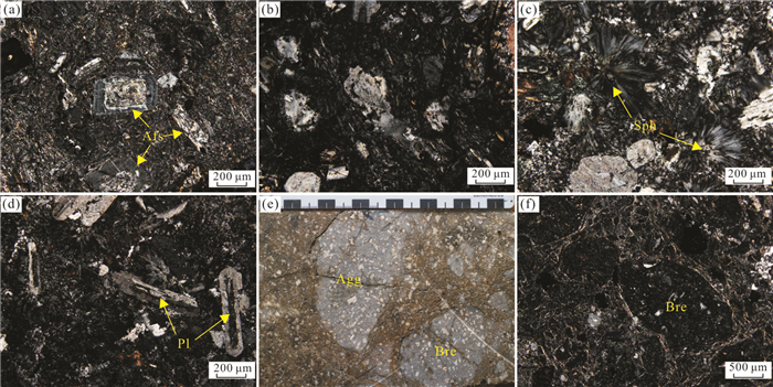
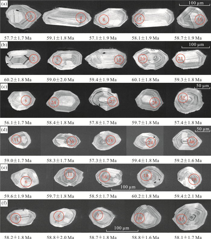
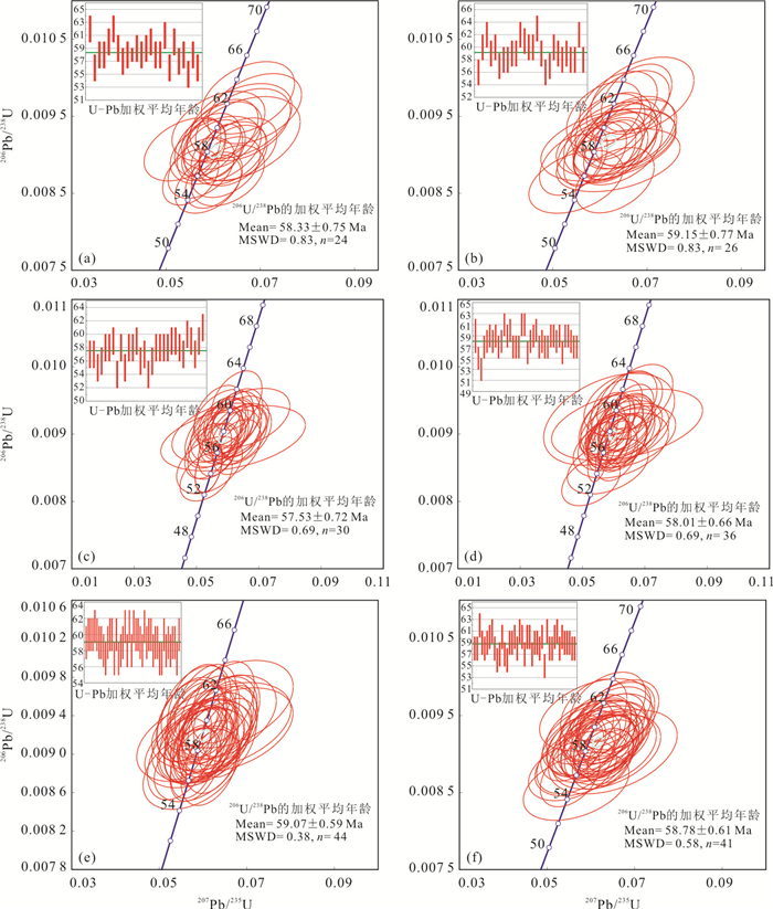
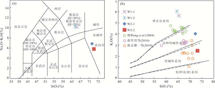
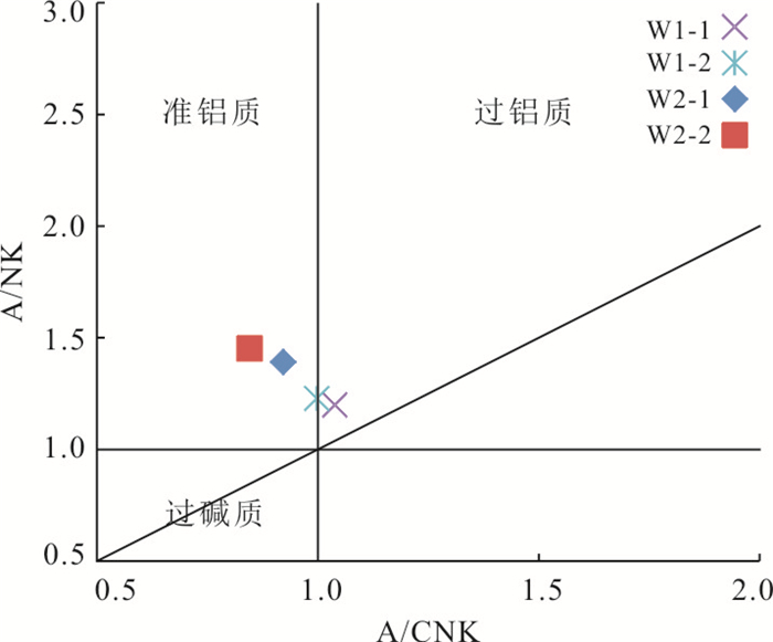
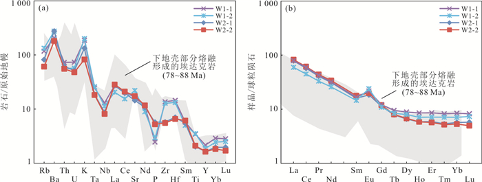
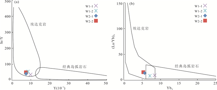
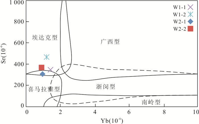
There are different understandings on the types, genesis and geodynamic mechanism of the volcanic rocks formed in the Early Cenozoic in the northern margin of the South China Sea. In this paper, it presents zircon U-Pb data and geochemical data for the trachytic agglomerate or breccia lava, trachyte, rhyolite and trachydacite revealed by drilling in Huizhou sag of the Pearl River Mouth basin. The results show that the Cenozoic volcanic rocks in the study area were formed at 57.53-59.15 Ma, near the boundary between Paleocene and Eocene, and fell into the Thanetian stage. These rocks are characterized by high SiO2(64.60%-73.22%), Al2O3(11.86%-16.57%), low MgO(1.16%-1.80%), high Sr(305.20×10⁻⁶-465.50×10⁻⁶, 371.15×10⁻⁶ on average), low Y(7.47×10⁻⁶-9.84×10⁻⁶), Yb(0.90×10⁻⁶-1.43×10⁻⁶) and high Sr/Y ratios (35.19-54.55). They are enriched in LREE and depleted in HREE, together with enrichment in large-ion lithophile elements (LILE) Ba, K and depletion in high field strength elements (HFSE) Nb, Ta, Ti and P, as well as small positive Eu anomalies, similar to those of adakite. These rocks are calc-alkaline, high-K calc-alkaline and shoshonite metalumious (A/CNK=0.85-1.04). The Early Paleogene adakites are interpreted as the products of partial melting of newly underplated mafic lower crust under garnet-amphibolite facies conditions. It is concluded that the Cenozoic delamination in the northern margin of the South China Sea plays an important role in the formation and evolution of magma.
There are different understandings on the types, genesis and geodynamic mechanism of the volcanic rocks formed in the Early Cenozoic in the northern margin of the South China Sea. In this paper, it presents zircon U-Pb data and geochemical data for the trachytic agglomerate or breccia lava, trachyte, rhyolite and trachydacite revealed by drilling in Huizhou sag of the Pearl River Mouth basin. The results show that the Cenozoic volcanic rocks in the study area were formed at 57.53-59.15 Ma, near the boundary between Paleocene and Eocene, and fell into the Thanetian stage. These rocks are characterized by high SiO2(64.60%-73.22%), Al2O3(11.86%-16.57%), low MgO(1.16%-1.80%), high Sr(305.20×10⁻⁶-465.50×10⁻⁶, 371.15×10⁻⁶ on average), low Y(7.47×10⁻⁶-9.84×10⁻⁶), Yb(0.90×10⁻⁶-1.43×10⁻⁶) and high Sr/Y ratios (35.19-54.55). They are enriched in LREE and depleted in HREE, together with enrichment in large-ion lithophile elements (LILE) Ba, K and depletion in high field strength elements (HFSE) Nb, Ta, Ti and P, as well as small positive Eu anomalies, similar to those of adakite. These rocks are calc-alkaline, high-K calc-alkaline and shoshonite metalumious (A/CNK=0.85-1.04). The Early Paleogene adakites are interpreted as the products of partial melting of newly underplated mafic lower crust under garnet-amphibolite facies conditions. It is concluded that the Cenozoic delamination in the northern margin of the South China Sea plays an important role in the formation and evolution of magma.
2020, 45(11): 4118-4127.
doi: 10.3799/dqkx.2019.274
Abstract:
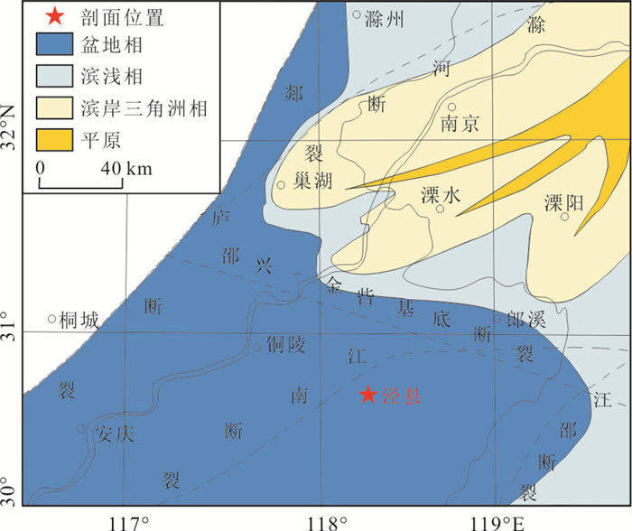
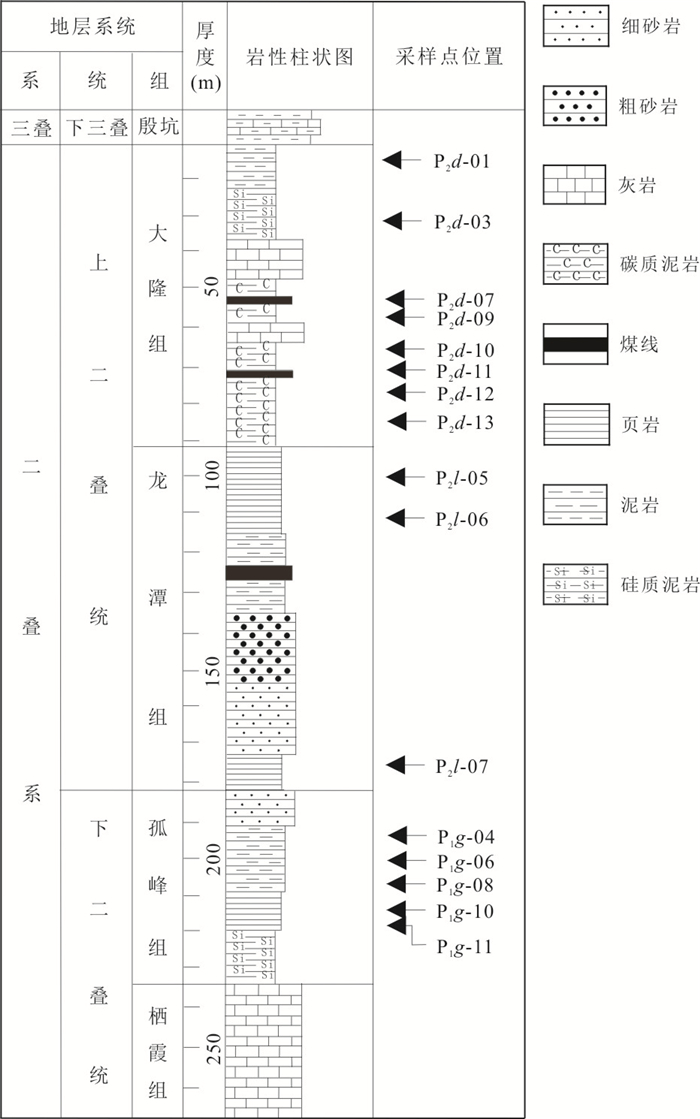
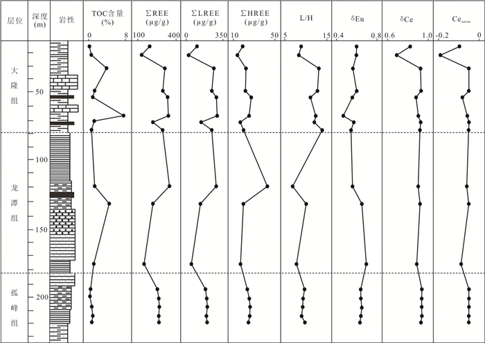
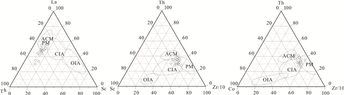
In order to find out the characteristics, provenance and geological significance of rare earth elements (REEs) in Permian shale in Lower Yangtze area, 16 samples collected from Dalong Formation, Longtan Formation and Gufeng Formation were selected for the trace and REE analyses. The results show that the REE distribution in research area is similar with upper crust, which is characterized by obvious "right-leaning" distribution pattern, with enrichment in LREE and depletion in HREE. In addition, Eu shows negative anomaly in a distinct "V" shape and Ce generally shows a slight negative anomaly based on REE curve. The characteristics of Ceanom(-0.07) and δCe(0.90) indicate that the mudstone is deposited in an anoxic environment which is conductive to the formation of excellent source rock. The value of (La/Yb)N reflects the vertical sedimentation rate in the study area as follows:Longtan Formation < Gufeng Formation < Dalong Formation. In the diagrams of La/Th-Hf and La/Yb-∑REE, it can be found that the parent rock is feldspathic-quartz, mainly intermediate to granite. By the comparison of REE characteristic parameters from graywackes in different settings, combined with La-Th-Sc, Th-Sc-Zr/10, Th-Co-Zr/10 triangle diagram, a conclusion can be drawn that the tectonic setting of the study area is determined to be a passive continental margin.
In order to find out the characteristics, provenance and geological significance of rare earth elements (REEs) in Permian shale in Lower Yangtze area, 16 samples collected from Dalong Formation, Longtan Formation and Gufeng Formation were selected for the trace and REE analyses. The results show that the REE distribution in research area is similar with upper crust, which is characterized by obvious "right-leaning" distribution pattern, with enrichment in LREE and depletion in HREE. In addition, Eu shows negative anomaly in a distinct "V" shape and Ce generally shows a slight negative anomaly based on REE curve. The characteristics of Ceanom(-0.07) and δCe(0.90) indicate that the mudstone is deposited in an anoxic environment which is conductive to the formation of excellent source rock. The value of (La/Yb)N reflects the vertical sedimentation rate in the study area as follows:Longtan Formation < Gufeng Formation < Dalong Formation. In the diagrams of La/Th-Hf and La/Yb-∑REE, it can be found that the parent rock is feldspathic-quartz, mainly intermediate to granite. By the comparison of REE characteristic parameters from graywackes in different settings, combined with La-Th-Sc, Th-Sc-Zr/10, Th-Co-Zr/10 triangle diagram, a conclusion can be drawn that the tectonic setting of the study area is determined to be a passive continental margin.

2020, 45(11): 4128-4142.
doi: 10.3799/dqkx.2020.136
Abstract:
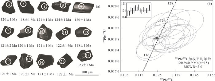
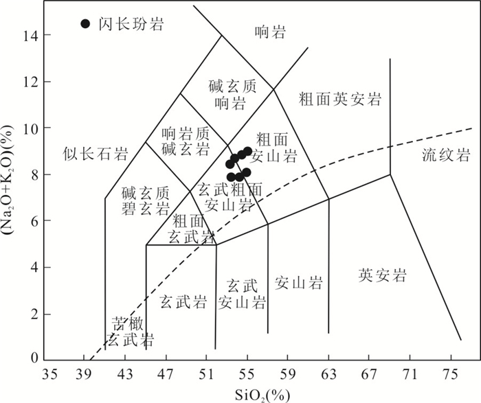
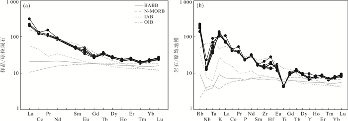
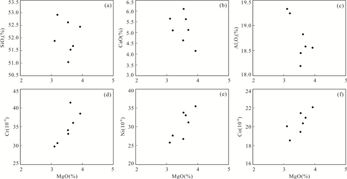
There are relatively few reports on the intermediate-acid intrusive rocks in the Bangonghu-Nujiang ophiolitic melange belt, the study on the petrogenesis and tectonic setting of this rocks is important to define the geodynamic evolution of Bangonghu-Nujiang Tethys oceanic. It reports zircon U-Pb age and major-trace elements for the diorite porphyrite from the Jiangma area in the Bangonghu-Nujiang suture zone. Zircon LA-ICP-MS U-Pb dating of the diorite porphyrite yields an Early Cretaceous age of a 121±1 Ma, indicating that the intruded rocks were formed in the late Early Cretaceous period. Geochemical studies show that diorite porphyrite has typical geochemical characteristics similar to the high-alumina basalts. They are characterized by high Al2O3 contents (18.2%-19.3%), and enriched in light rare earth elements and large ion lithophile elements (Rb and K), but depleted in high field strength elements (Nb, Ta and Ti). All of these geochemistry characteristics of the rocks are the same as the typically island arc basalts. Combined with the regional geological setting, the diorite porphyrite may be formed in an accretive arc environment related to the southward subduction of Bangonghu-Nujiang Tethys oceanic crust in late Early Cretaceous. The fluids derived from the subducted oceanic crust would metasomatize the overlying mantle peridotite to generate the mantle source of the studied diorite porphyrite.
There are relatively few reports on the intermediate-acid intrusive rocks in the Bangonghu-Nujiang ophiolitic melange belt, the study on the petrogenesis and tectonic setting of this rocks is important to define the geodynamic evolution of Bangonghu-Nujiang Tethys oceanic. It reports zircon U-Pb age and major-trace elements for the diorite porphyrite from the Jiangma area in the Bangonghu-Nujiang suture zone. Zircon LA-ICP-MS U-Pb dating of the diorite porphyrite yields an Early Cretaceous age of a 121±1 Ma, indicating that the intruded rocks were formed in the late Early Cretaceous period. Geochemical studies show that diorite porphyrite has typical geochemical characteristics similar to the high-alumina basalts. They are characterized by high Al2O3 contents (18.2%-19.3%), and enriched in light rare earth elements and large ion lithophile elements (Rb and K), but depleted in high field strength elements (Nb, Ta and Ti). All of these geochemistry characteristics of the rocks are the same as the typically island arc basalts. Combined with the regional geological setting, the diorite porphyrite may be formed in an accretive arc environment related to the southward subduction of Bangonghu-Nujiang Tethys oceanic crust in late Early Cretaceous. The fluids derived from the subducted oceanic crust would metasomatize the overlying mantle peridotite to generate the mantle source of the studied diorite porphyrite.
2020, 45(11): 4143-4152.
doi: 10.3799/dqkx.2020.002
Abstract:
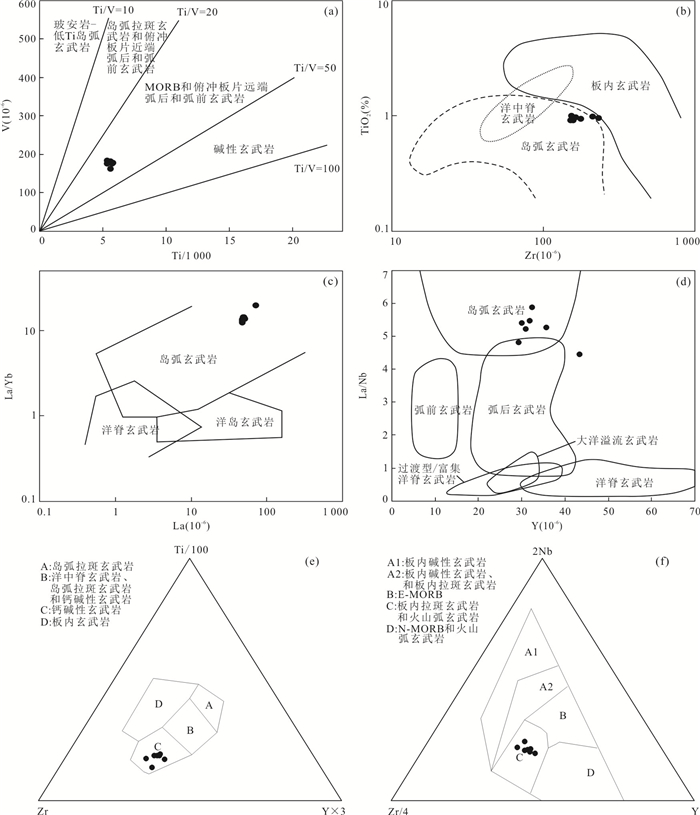
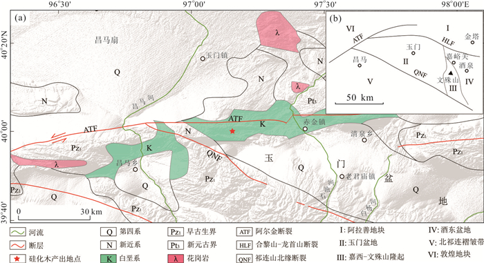
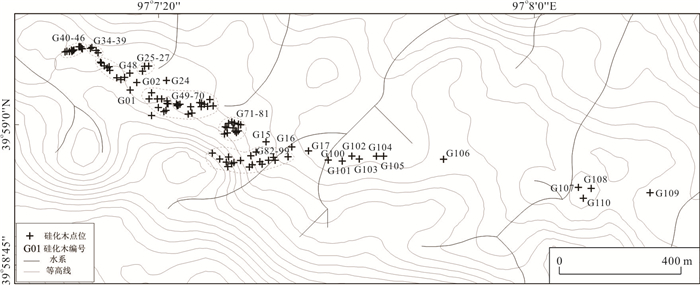
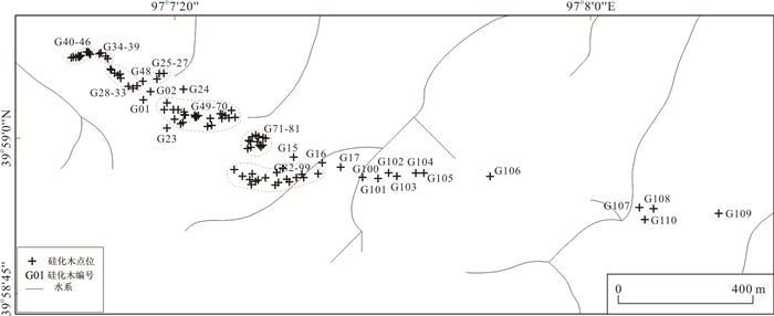
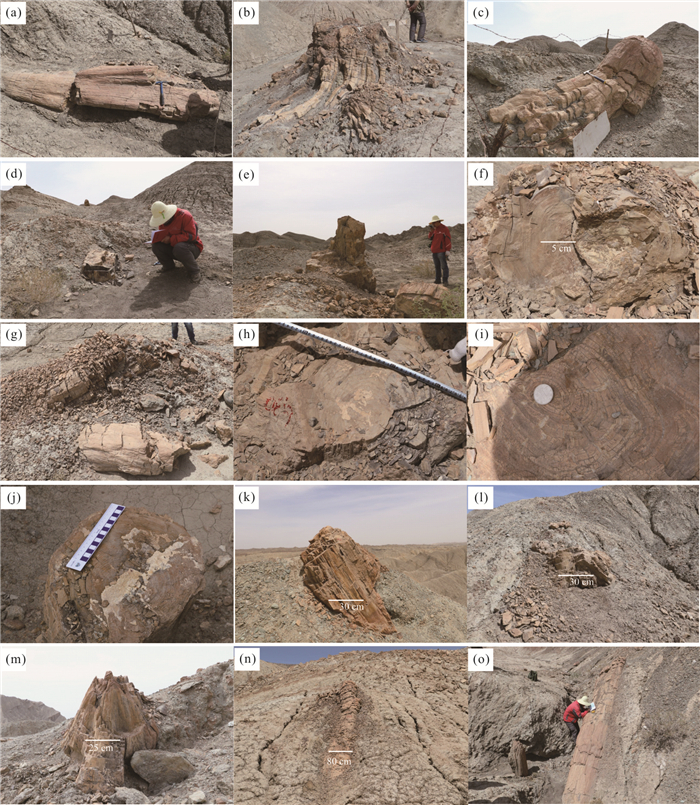
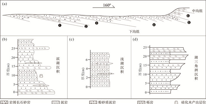
The Hongliuxia region of Yumen basin in northern margin of the Tibetan plateau is the only place where the silicified woods are concentrated and consecutively distributed. These cluster extinctions of the ancient extinct life may be related to the catastrophic event usually. In this paper, it presents an account of the characteristics and strata bearing of the silicified woods, further discusses the evolution of the Yumen basin and the formation of the silicified woods. The results show that the Yumen basin has experienced the growth, expansion and the shrink of the ancient lake. During the growth and the expansion stage of the lake, the paleoclimate was hot and moist, and trees were growing around the ancient lakeside. During the Early Cretaceous between 102-120 Ma, with the reactivation of Altyn Tagh fault (ATF), large-scale volcanic activities occurred in Yumen basin. The volcanism led to the large-scale burning and burial of the tall arbor tree vegetation, finally forming the silicified wood fossil belt. Formation and evolution of Yumen basin are mainly controlled and affected by the activity of the ATF since the Early Cretaceous.
The Hongliuxia region of Yumen basin in northern margin of the Tibetan plateau is the only place where the silicified woods are concentrated and consecutively distributed. These cluster extinctions of the ancient extinct life may be related to the catastrophic event usually. In this paper, it presents an account of the characteristics and strata bearing of the silicified woods, further discusses the evolution of the Yumen basin and the formation of the silicified woods. The results show that the Yumen basin has experienced the growth, expansion and the shrink of the ancient lake. During the growth and the expansion stage of the lake, the paleoclimate was hot and moist, and trees were growing around the ancient lakeside. During the Early Cretaceous between 102-120 Ma, with the reactivation of Altyn Tagh fault (ATF), large-scale volcanic activities occurred in Yumen basin. The volcanism led to the large-scale burning and burial of the tall arbor tree vegetation, finally forming the silicified wood fossil belt. Formation and evolution of Yumen basin are mainly controlled and affected by the activity of the ATF since the Early Cretaceous.
2020, 45(11): 4153-4175.
doi: 10.3799/dqkx.2019.287
Abstract:
Geochemistry, zircon U-Pb dating and heavy mineral compositional analysis were carried out for the clastic rocks from Ordovician-Devonian drilling samples, to constrain the tectonic evolution of Proto-Tethys in southwestern Tarim. The zircon grains are divided into three genetic types, i.e. magmatic zircon, metamorphic zircon and trapped or residual zircon, recording the tectonic-thermal events in the periods of the 482-443 Ma, 438-425 Ma and 414-406 Ma since the Cambrian, as well as the Neoproterozoic rift magma events between 840 Ma and 750 Ma. The clastic rocks have high content of SiO2 but relatively low content of Al2O3 and TFe2O3+MgO. They are characterized by right-dip chondrite-normalized REE pattern and flat HREE distribution, with weak to medium Eu negative anomaly. The ratios of trace elements, such as Th/U ratio, Cr/Zr ratio, Rb/Cs ratio, and La/Sc, suggests the terrigenous clastic components were derived from the felsic rocks in upper crust. It is assumed that the tectonic setting of sedimentary basin was characterized by continental island arc and active continental margin in late Ordovician. From the Early Silurian to Middle Devonian, the provenance was then predominated by continental island arc and passive continental margin, and mingled with active continental margin slightly. After the Late Devonian, it gradually changed over to evidential passive continental margin. It is indicated by the heavy minerals that the medium to acid magma activity became frequent while the basic magma activity became quiet during the time from Early Silurian to Middle Devonian, and the mountain uplifted massively since Late Devonian. Thus, the tectonic evolution of Proto-Tethys in south-western margin of Tarim could be divided into three stages, i.e. the northward subduction in Ordovician, the closure of back-arc ocean and folding orogeny in Silurian, and post-collision extension in Devonian.
Geochemistry, zircon U-Pb dating and heavy mineral compositional analysis were carried out for the clastic rocks from Ordovician-Devonian drilling samples, to constrain the tectonic evolution of Proto-Tethys in southwestern Tarim. The zircon grains are divided into three genetic types, i.e. magmatic zircon, metamorphic zircon and trapped or residual zircon, recording the tectonic-thermal events in the periods of the 482-443 Ma, 438-425 Ma and 414-406 Ma since the Cambrian, as well as the Neoproterozoic rift magma events between 840 Ma and 750 Ma. The clastic rocks have high content of SiO2 but relatively low content of Al2O3 and TFe2O3+MgO. They are characterized by right-dip chondrite-normalized REE pattern and flat HREE distribution, with weak to medium Eu negative anomaly. The ratios of trace elements, such as Th/U ratio, Cr/Zr ratio, Rb/Cs ratio, and La/Sc, suggests the terrigenous clastic components were derived from the felsic rocks in upper crust. It is assumed that the tectonic setting of sedimentary basin was characterized by continental island arc and active continental margin in late Ordovician. From the Early Silurian to Middle Devonian, the provenance was then predominated by continental island arc and passive continental margin, and mingled with active continental margin slightly. After the Late Devonian, it gradually changed over to evidential passive continental margin. It is indicated by the heavy minerals that the medium to acid magma activity became frequent while the basic magma activity became quiet during the time from Early Silurian to Middle Devonian, and the mountain uplifted massively since Late Devonian. Thus, the tectonic evolution of Proto-Tethys in south-western margin of Tarim could be divided into three stages, i.e. the northward subduction in Ordovician, the closure of back-arc ocean and folding orogeny in Silurian, and post-collision extension in Devonian.
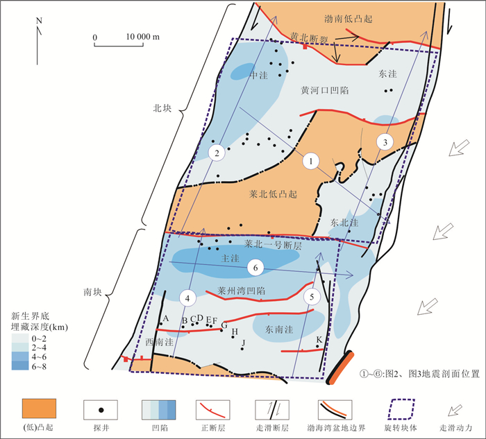
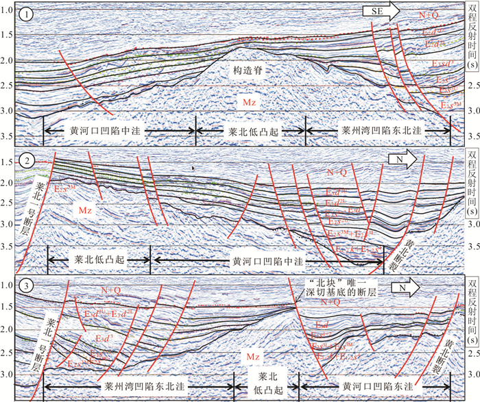
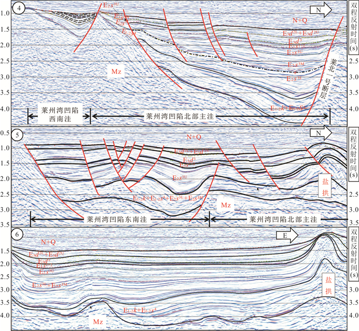
2020, 45(11): 4176-4186.
doi: 10.3799/dqkx.2019.288
Abstract:
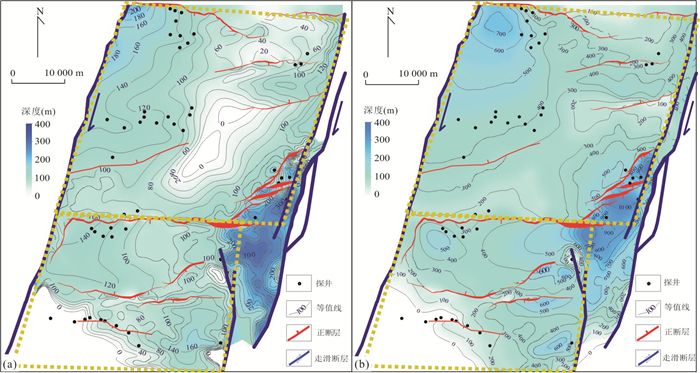
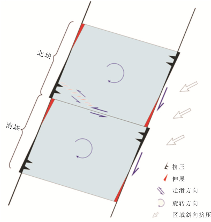
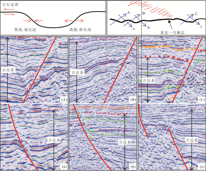
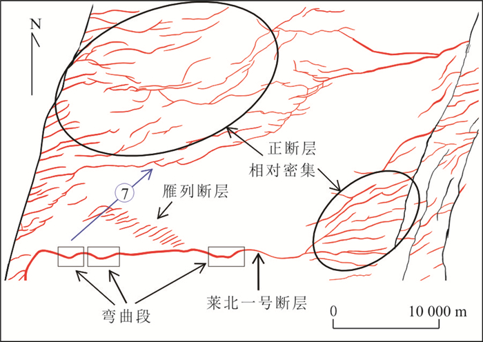
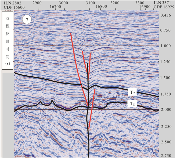
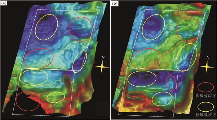
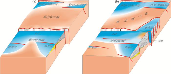
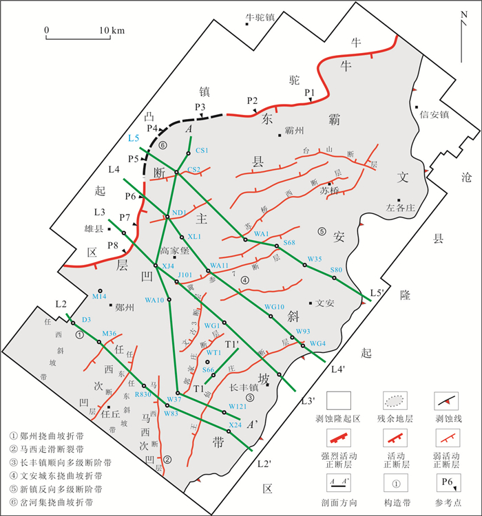
In order to explore the starting time of dextral strike slip of the Laizhou Bay segment of the Tanlu fault and its tectonic response, structural sedimentary responses closely related to right strike slip movement are studied in depth based on the latest drilling data and 3D seismic data. It is found that the clamped geological block rotated clockwise passively as soon as the double track strike slip began its dextral strike slip, resulting in differential strain (extension or extrusion) effect. During a regional extensional background, subsiding would be promoted if the extension effect is produced, enlarging the subsidence area of the partial depression and changing the part of the uplift into the depression area, both proved to be hydrocarbon rich depressions. If the extrusion effect is produced, subsiding would be inhibited, resulting in the slowdown, even shrinking, uplifting and eroding of the settlement of some depression areas, and the potential of hydrocarbon generation decreases or even disappears, and convex areas still maintain a state of protruding. The comprehensive information of stratigraphic residuals and regional tectonic environment indicate that tectonic responses to the dextral strike slip of the Tanlu fault (Laizhou Bay segment) simultaneously appeared when the E2s3M was deposited.
In order to explore the starting time of dextral strike slip of the Laizhou Bay segment of the Tanlu fault and its tectonic response, structural sedimentary responses closely related to right strike slip movement are studied in depth based on the latest drilling data and 3D seismic data. It is found that the clamped geological block rotated clockwise passively as soon as the double track strike slip began its dextral strike slip, resulting in differential strain (extension or extrusion) effect. During a regional extensional background, subsiding would be promoted if the extension effect is produced, enlarging the subsidence area of the partial depression and changing the part of the uplift into the depression area, both proved to be hydrocarbon rich depressions. If the extrusion effect is produced, subsiding would be inhibited, resulting in the slowdown, even shrinking, uplifting and eroding of the settlement of some depression areas, and the potential of hydrocarbon generation decreases or even disappears, and convex areas still maintain a state of protruding. The comprehensive information of stratigraphic residuals and regional tectonic environment indicate that tectonic responses to the dextral strike slip of the Tanlu fault (Laizhou Bay segment) simultaneously appeared when the E2s3M was deposited.

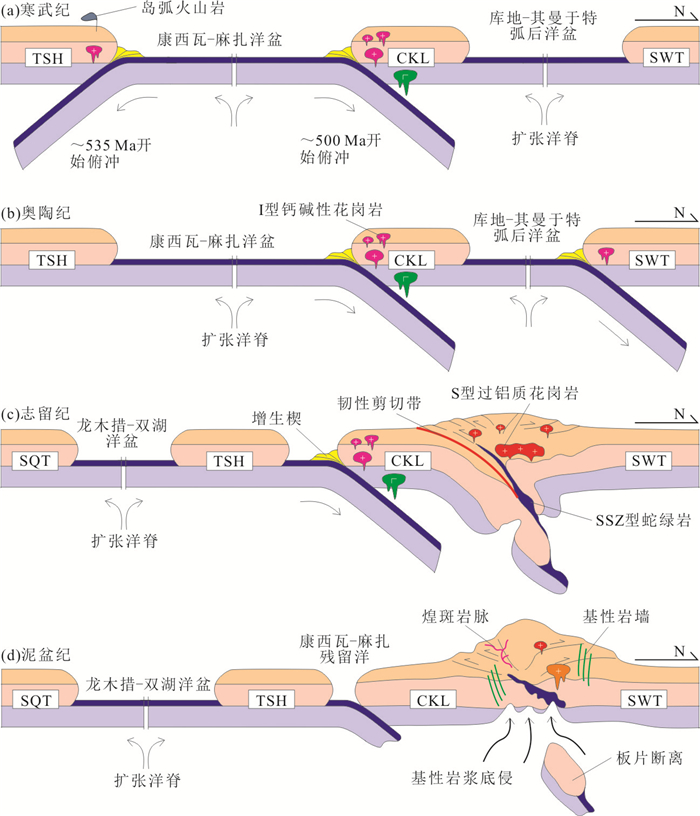
2020, 45(11): 4187-4197.
doi: 10.3799/dqkx.2020.053
Abstract:
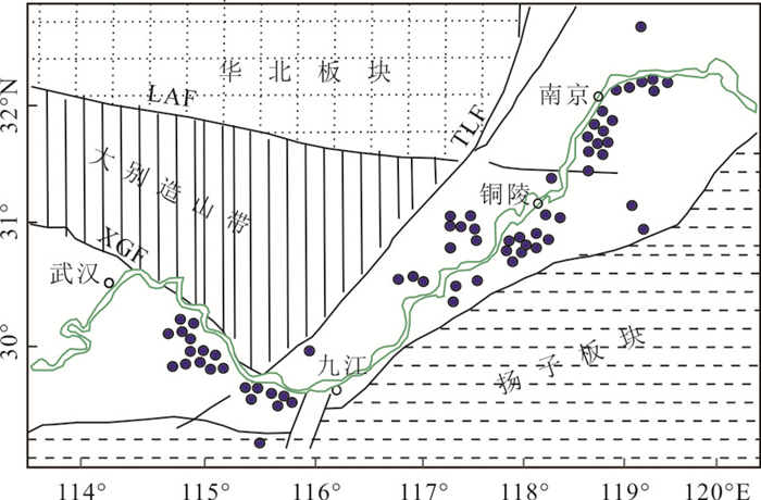
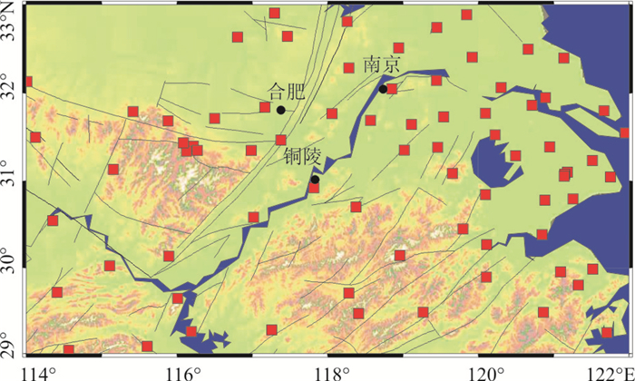
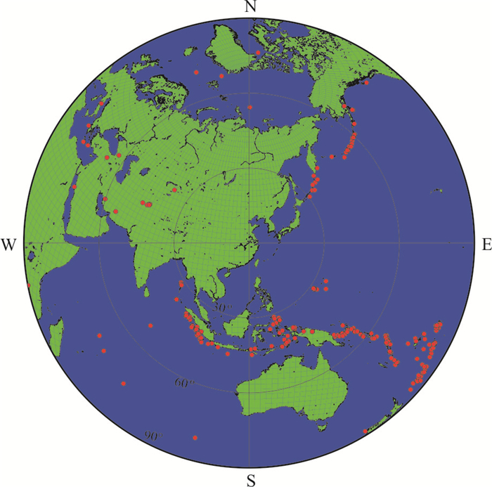
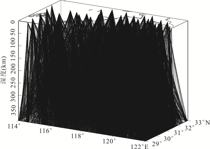
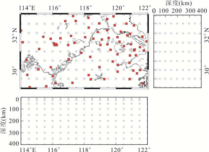
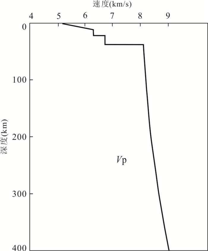
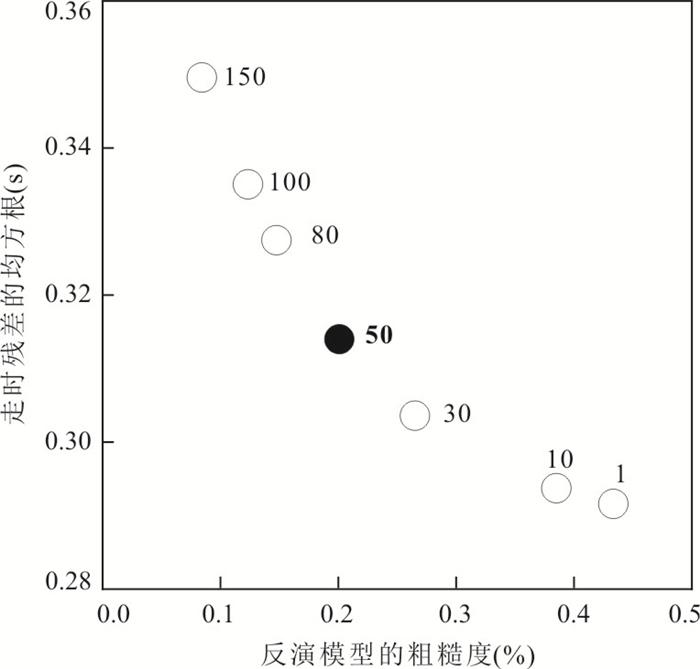
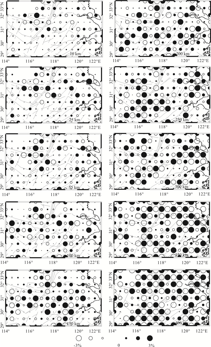
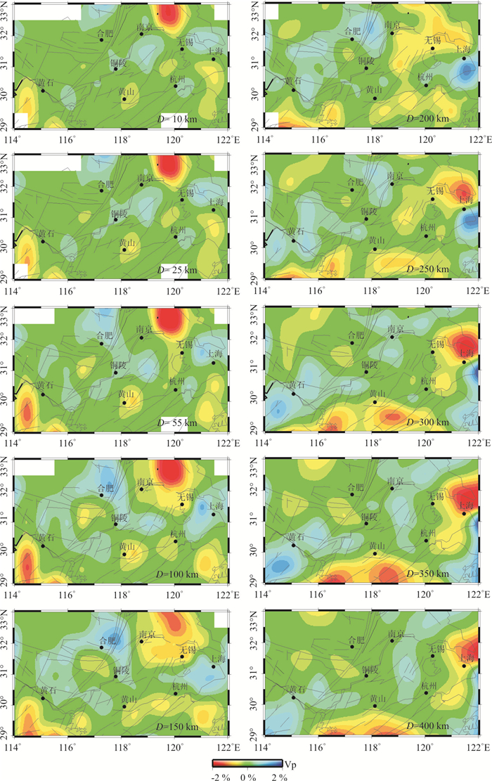
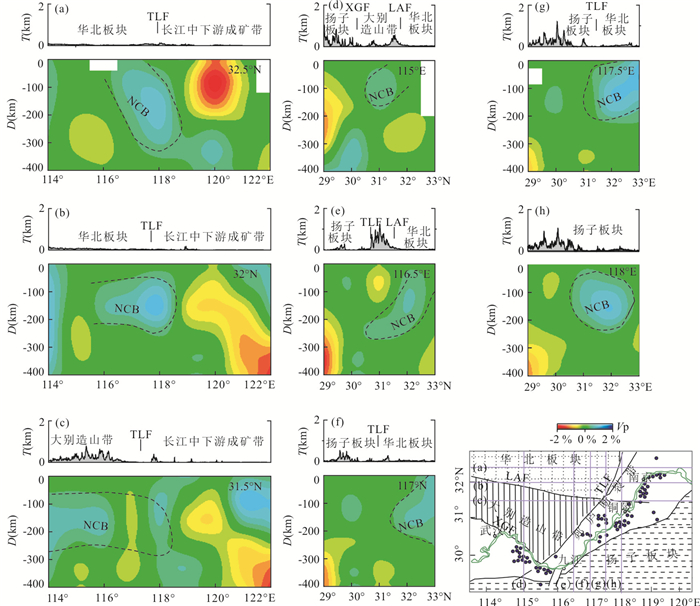
What the North China block southeastward subducted under the Yangtze plate revealed by the tomography images is important for reunderstanding the metallogenic mechanism in the Middle and Lower reaches of the Yangtze River. In this paper, It determines the 3-D P-wave velocity structure beneath the Middle and Lower Reaches of Yangtze River metallogenic belt by using waveform data recorded by the China Seismic Network Center including Hubei, Henan, Anhui, Jiangxi, Zhejiang and Jiangsu seismic networks. The results show that North China block subducted southeastward under the Yangtze plate in the Triassic period. It is concluded that the deep suture between North China block and Yangtze block is located in the south of Dabie orogenic belt to the west of Tanlu fault and in the Yangtze River to the east of Tanlu fault. After the Late Mesozoic tectonic transformation, the deep suture belt was reactivated and became a channel for the uplift of ore-bearing magma and fluid in Mesozoic, and formed a famous large metallogenic belt.
What the North China block southeastward subducted under the Yangtze plate revealed by the tomography images is important for reunderstanding the metallogenic mechanism in the Middle and Lower reaches of the Yangtze River. In this paper, It determines the 3-D P-wave velocity structure beneath the Middle and Lower Reaches of Yangtze River metallogenic belt by using waveform data recorded by the China Seismic Network Center including Hubei, Henan, Anhui, Jiangxi, Zhejiang and Jiangsu seismic networks. The results show that North China block subducted southeastward under the Yangtze plate in the Triassic period. It is concluded that the deep suture between North China block and Yangtze block is located in the south of Dabie orogenic belt to the west of Tanlu fault and in the Yangtze River to the east of Tanlu fault. After the Late Mesozoic tectonic transformation, the deep suture belt was reactivated and became a channel for the uplift of ore-bearing magma and fluid in Mesozoic, and formed a famous large metallogenic belt.
2020, 45(11): 4198-4206.
doi: 10.3799/dqkx.2020.021
Abstract:
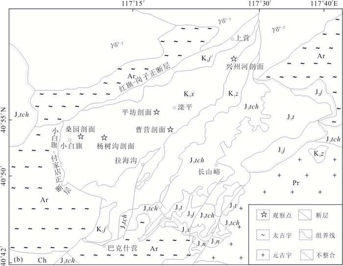
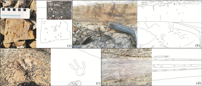
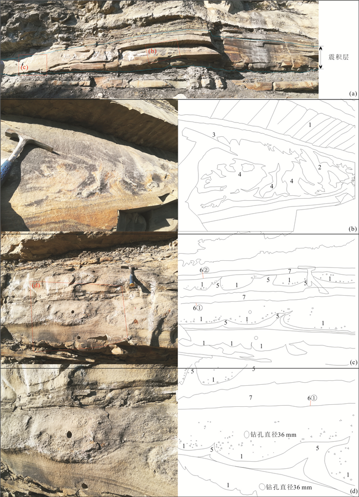
In order to improve the understanding of soft-sediment deformation structures caused by earthquake of the Xiguayuan Formation in Luanping basin, they were studied by the method of combination of both the field investigation with laboratory analysis, and the macroscopic sedimentary system with microscopic soft-sediment deformation structure. In two sections at the angle between the main and secondary basin-controlling faults in the basin, pillow structure, liquefied sand veins, liquefied sand emplacement, liquefied breccias, liquefaction curl deformation, liquefied droplet, flame structure, ball-and-pillow structure, pillow beds, load structure and seismic unconformity plane were developed. Seismites deposited continuously in fan delta front. According to the location of these soft-sediment deformation, their association, continuous development and regional distribution, two successive earthquakes can be identified.
In order to improve the understanding of soft-sediment deformation structures caused by earthquake of the Xiguayuan Formation in Luanping basin, they were studied by the method of combination of both the field investigation with laboratory analysis, and the macroscopic sedimentary system with microscopic soft-sediment deformation structure. In two sections at the angle between the main and secondary basin-controlling faults in the basin, pillow structure, liquefied sand veins, liquefied sand emplacement, liquefied breccias, liquefaction curl deformation, liquefied droplet, flame structure, ball-and-pillow structure, pillow beds, load structure and seismic unconformity plane were developed. Seismites deposited continuously in fan delta front. According to the location of these soft-sediment deformation, their association, continuous development and regional distribution, two successive earthquakes can be identified.
2020, 45(11): 4207-4217.
doi: 10.3799/dqkx.2020.003
Abstract:
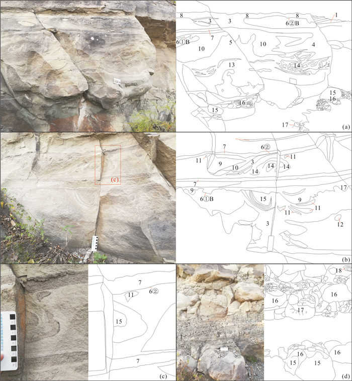
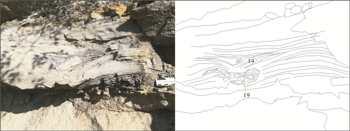
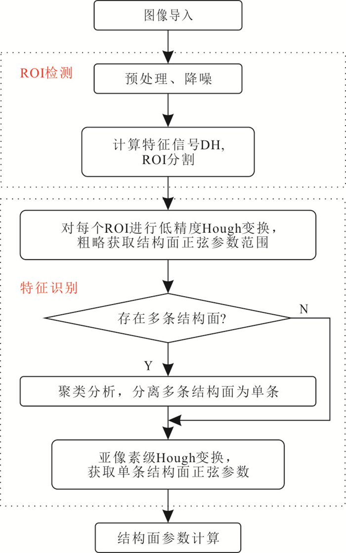
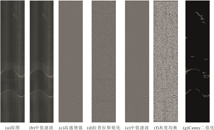
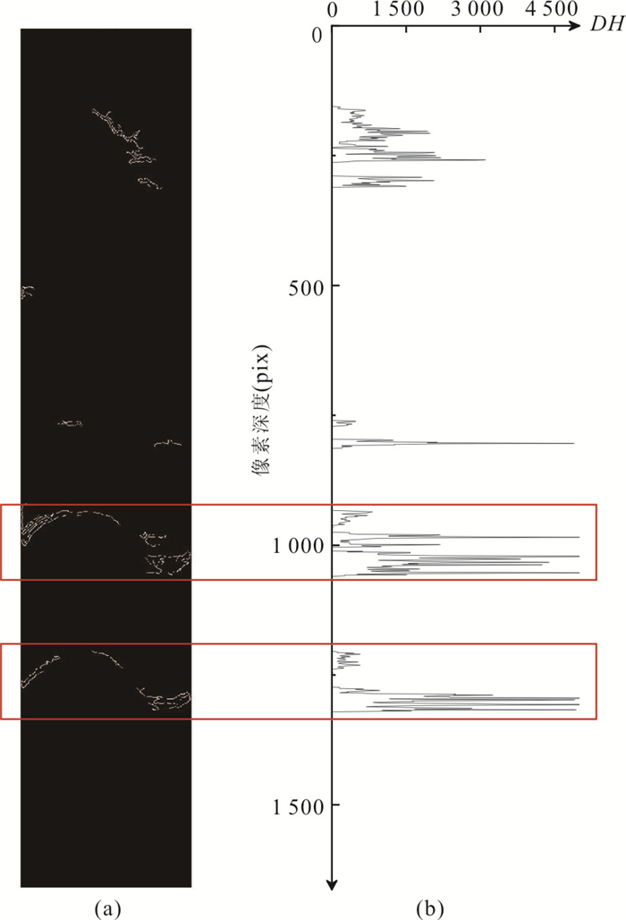
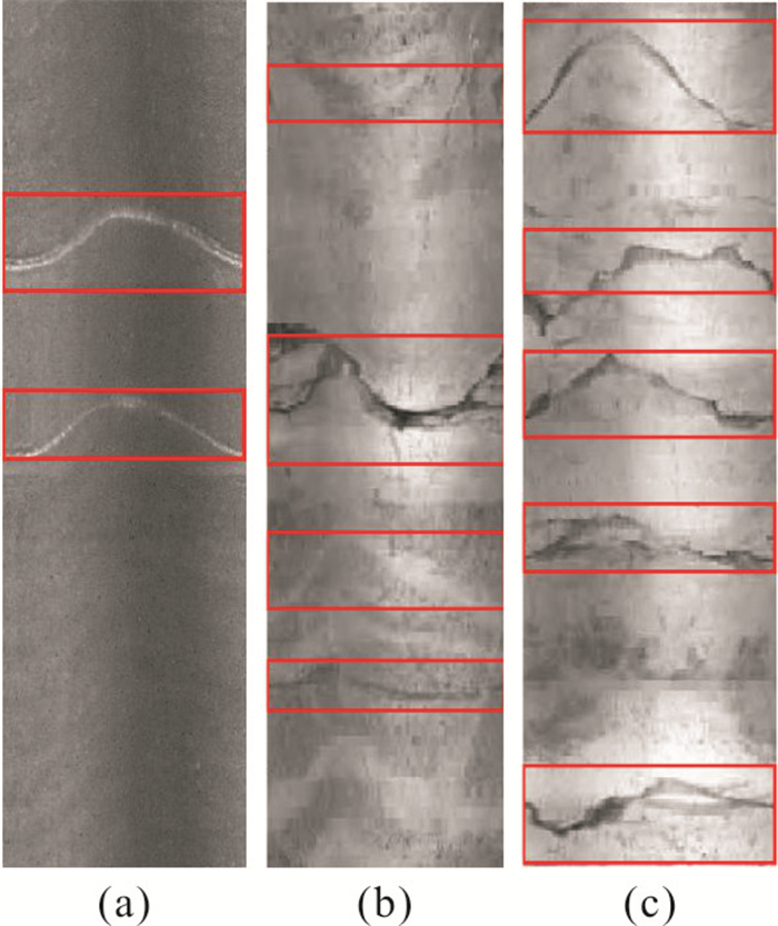
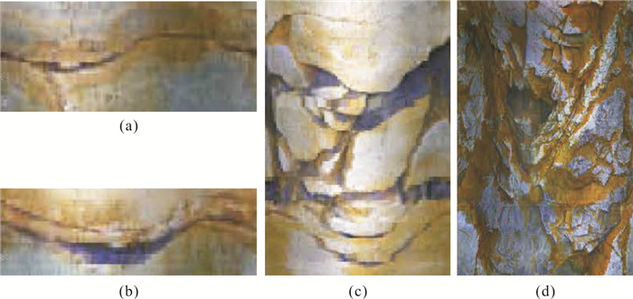
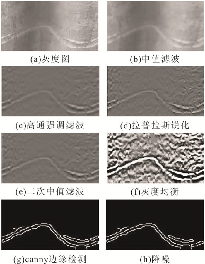
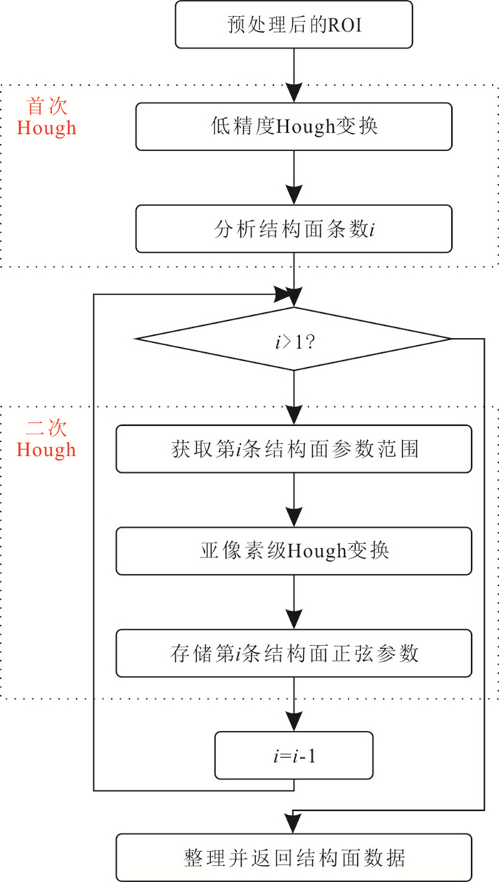
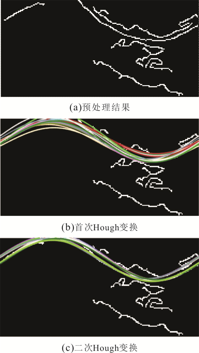
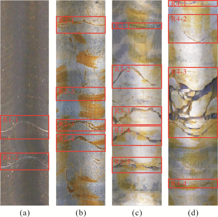
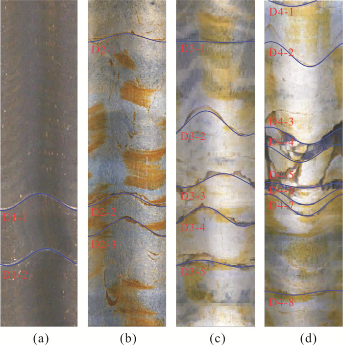
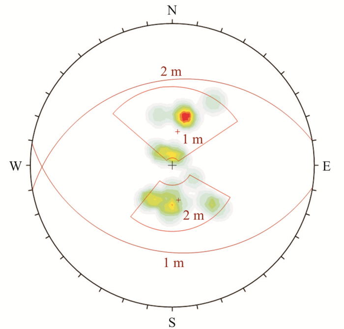
Aiming at the limitations of previous Digital Borehole Image Analysis Technology, a new analysis scheme to realize automatic quantitative analysis of borehole inner wall images collected by Borehole Camera Technology (BCT) was developed. First, feature signal DH was designed to detect the pre-treated image and obtain Region of Interest (ROI) automatically. Second, low accuracy Hough transform was used to detect the distribution of discontinuities in the ROI rapidly. After separating discontinuities with clustering algorithm, the sub-pixel Hough transform was carried out for single discontinuity to obtain its sine parameters. Finally, the dip direction and dip of each single discontinuity were calculated using its sine parameters. In the case study, the automatic segmentation and feature recognition of the discontinuities in the digital images from the left bank of Rumei hydropower station were completed using proposed method, and the geometric data of discontinuities matched with the results of traditional artificial assistance method, verifying the reliability of proposed method.
Aiming at the limitations of previous Digital Borehole Image Analysis Technology, a new analysis scheme to realize automatic quantitative analysis of borehole inner wall images collected by Borehole Camera Technology (BCT) was developed. First, feature signal DH was designed to detect the pre-treated image and obtain Region of Interest (ROI) automatically. Second, low accuracy Hough transform was used to detect the distribution of discontinuities in the ROI rapidly. After separating discontinuities with clustering algorithm, the sub-pixel Hough transform was carried out for single discontinuity to obtain its sine parameters. Finally, the dip direction and dip of each single discontinuity were calculated using its sine parameters. In the case study, the automatic segmentation and feature recognition of the discontinuities in the digital images from the left bank of Rumei hydropower station were completed using proposed method, and the geometric data of discontinuities matched with the results of traditional artificial assistance method, verifying the reliability of proposed method.

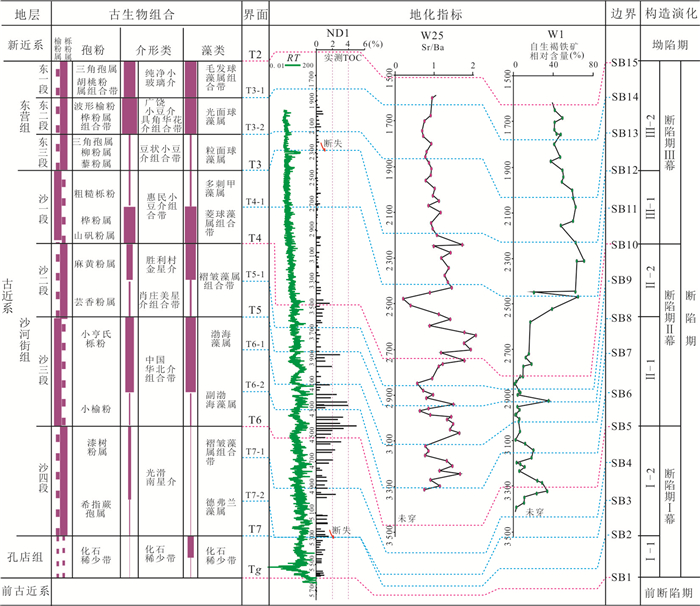
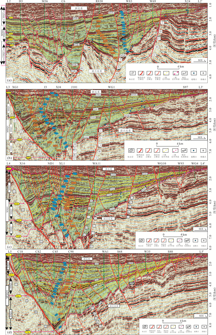
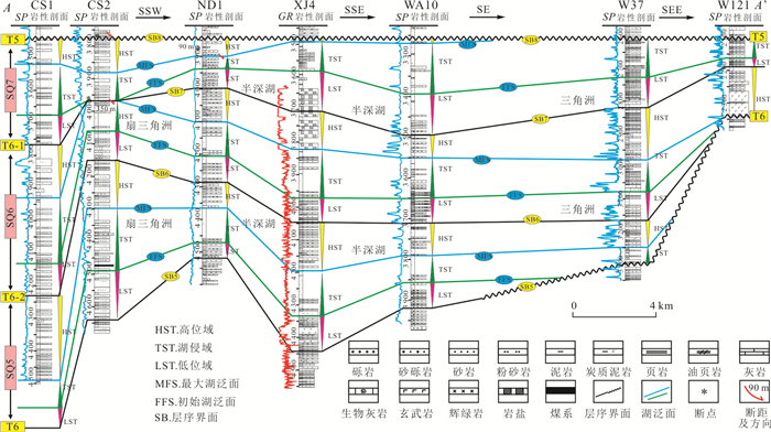
2020, 45(11): 4218-4235.
doi: 10.3799/dqkx.2020.013
Abstract:
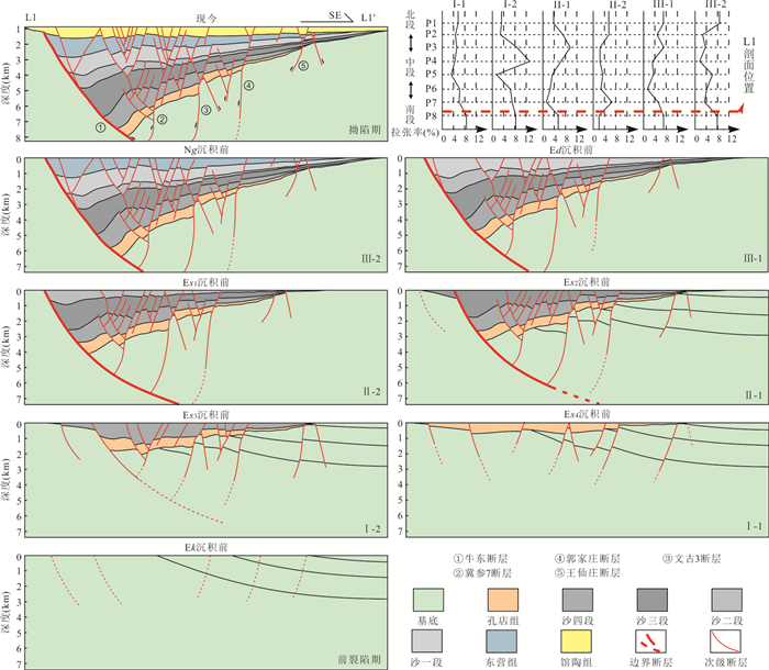
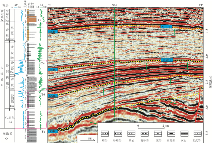
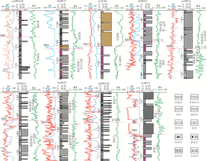
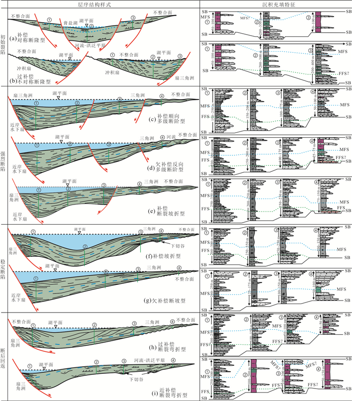
Unconformity interface is considered to be an isochronal interface. In lacustrine basin, these unconformity interfaces of different sizes usually correspond to sequence boundaries of different levels. In this study, It takes the typical asymmetrical half-graben of the Paleogene Baxian sag, in Bohai Bay basin as the study object, and is based on 2 552 km2 3D seismic data, combined with more than 800 wells/logs, cores and previous research results. Utilizing tectonic-sequence analysis method, starting with the basin structure analysis, in this paper it analyzes the structural evolution and unconformity surface characteristics, sorts out the unconformity surface and the corresponding relationship between the integration surface and the sequence interface according to the structural strata, and clarifies the sequence archtecture under the different provenance and paleostructures. The Paleogene in Baxian sag is divided into 1 first-order sequence, 3 second-order sequences and 14 third-order sequences, and four types and nine sedimentary filling patterns under established sequence framework. It is believed that the filling process of sequence is similar to tectonic activity, and has the characteristics of segmentation and episode. The sequence filling of lacustrine rift basin is diverse, the sequence cycle structure is asymmetric, and the system tract is incomplete. By establishing a typical sequence architecture and sedimentary model in rift basin, it provides the necessary theoretical methods and technical support for lithologic oil and gas exploration in the same type of basin.
Unconformity interface is considered to be an isochronal interface. In lacustrine basin, these unconformity interfaces of different sizes usually correspond to sequence boundaries of different levels. In this study, It takes the typical asymmetrical half-graben of the Paleogene Baxian sag, in Bohai Bay basin as the study object, and is based on 2 552 km2 3D seismic data, combined with more than 800 wells/logs, cores and previous research results. Utilizing tectonic-sequence analysis method, starting with the basin structure analysis, in this paper it analyzes the structural evolution and unconformity surface characteristics, sorts out the unconformity surface and the corresponding relationship between the integration surface and the sequence interface according to the structural strata, and clarifies the sequence archtecture under the different provenance and paleostructures. The Paleogene in Baxian sag is divided into 1 first-order sequence, 3 second-order sequences and 14 third-order sequences, and four types and nine sedimentary filling patterns under established sequence framework. It is believed that the filling process of sequence is similar to tectonic activity, and has the characteristics of segmentation and episode. The sequence filling of lacustrine rift basin is diverse, the sequence cycle structure is asymmetric, and the system tract is incomplete. By establishing a typical sequence architecture and sedimentary model in rift basin, it provides the necessary theoretical methods and technical support for lithologic oil and gas exploration in the same type of basin.
2020, 45(11): 4236-4253.
doi: 10.3799/dqkx.2020.011
Abstract:
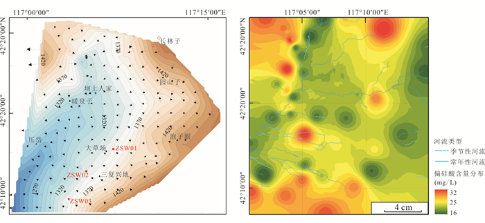
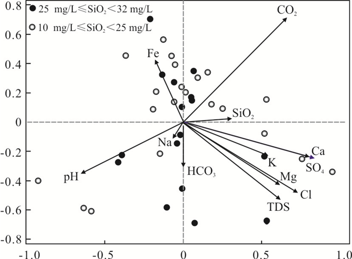
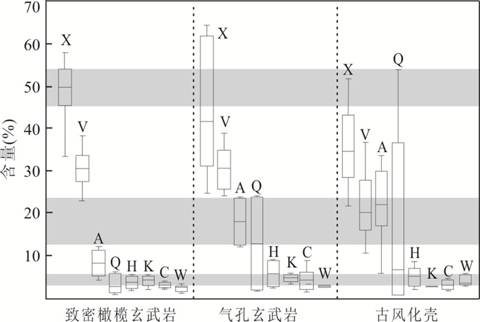
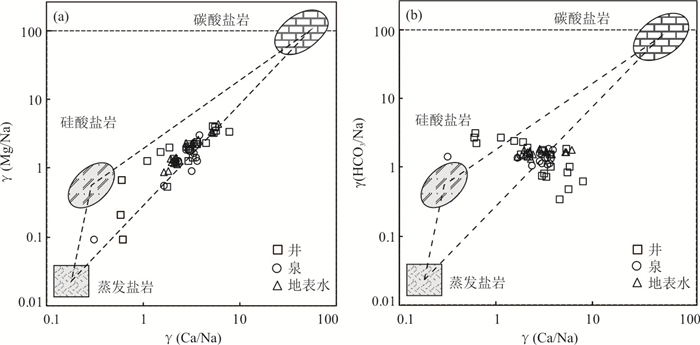
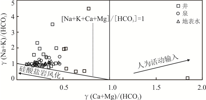
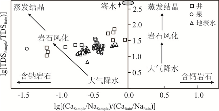
Metasilicate mineral groundwater is widely distributed in basaltic area of Bashang area in North Hebei Province. It is of great significance to ascertain the formation mechanism and water-rock interaction process for the rational development and utilization of mineral water and the water conservation function of Beijing-Tianjin-Hebei region. Hydrochemical components statistical analysis, chemical weathering process of basaltic, mineral equilibrium phase of water-rock interaction process, δD, δ18O, δ13C isotopes and radioisotope dating by 14C were used to identify the geological construction constraints and ascertain the formation mechanism of metasilicate mineral groundwater. The results show that the mineral groundwater of study area is characterized by low mineralization while the main hydrochemical types of groundwater are HCO3- Ca·Mg and HCO3- Na·Ca. The outcropping mechanism of mineral water can be divided into two types:deep cyclic leaching of tectonic faults and stratified enrichment of recharge type. The age of groundwater in the upper paleoweathering crust is about 4 050 a, and the dissolved inorganic carbon of groundwater comes from the mixing of soil CO2 and mantle CO2. Metasilicic acid in groundwater originates from the weathering and hydrolysis of plagioclase, pyroxene and forsterite in basaltic. Hydrogeochemical response of rock weathering is controlled by rock mineral leaching and affected by hydrochemical parameters cation exchange. The formation and distribution of metasilicate mineral water are restricted by the basalt geological construction, and controlled by weathering mechanism of rocks and hydrogeochemical conditions.
Metasilicate mineral groundwater is widely distributed in basaltic area of Bashang area in North Hebei Province. It is of great significance to ascertain the formation mechanism and water-rock interaction process for the rational development and utilization of mineral water and the water conservation function of Beijing-Tianjin-Hebei region. Hydrochemical components statistical analysis, chemical weathering process of basaltic, mineral equilibrium phase of water-rock interaction process, δD, δ18O, δ13C isotopes and radioisotope dating by 14C were used to identify the geological construction constraints and ascertain the formation mechanism of metasilicate mineral groundwater. The results show that the mineral groundwater of study area is characterized by low mineralization while the main hydrochemical types of groundwater are HCO3- Ca·Mg and HCO3- Na·Ca. The outcropping mechanism of mineral water can be divided into two types:deep cyclic leaching of tectonic faults and stratified enrichment of recharge type. The age of groundwater in the upper paleoweathering crust is about 4 050 a, and the dissolved inorganic carbon of groundwater comes from the mixing of soil CO2 and mantle CO2. Metasilicic acid in groundwater originates from the weathering and hydrolysis of plagioclase, pyroxene and forsterite in basaltic. Hydrogeochemical response of rock weathering is controlled by rock mineral leaching and affected by hydrochemical parameters cation exchange. The formation and distribution of metasilicate mineral water are restricted by the basalt geological construction, and controlled by weathering mechanism of rocks and hydrogeochemical conditions.

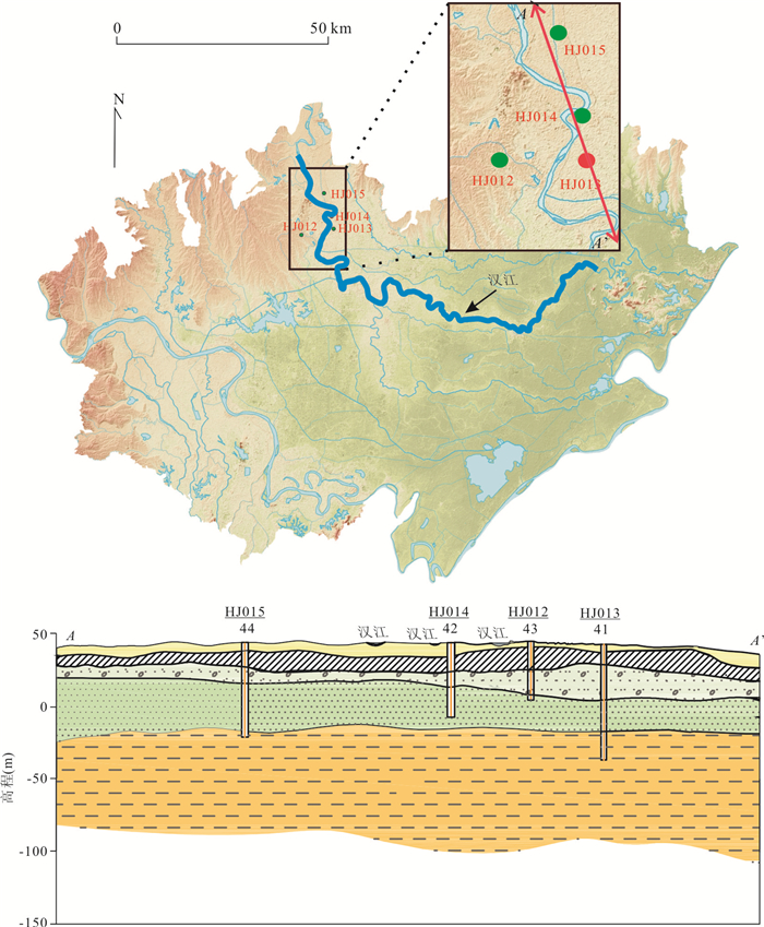
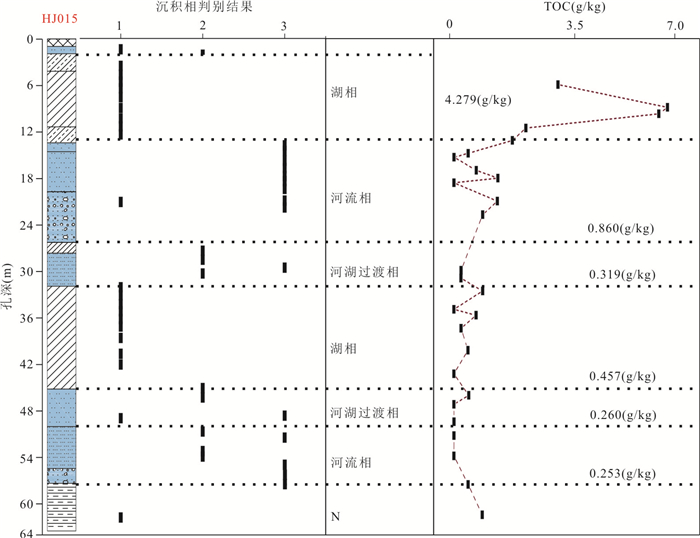
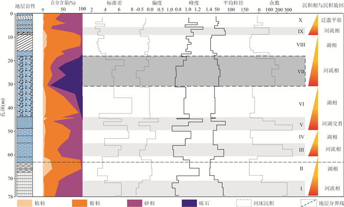
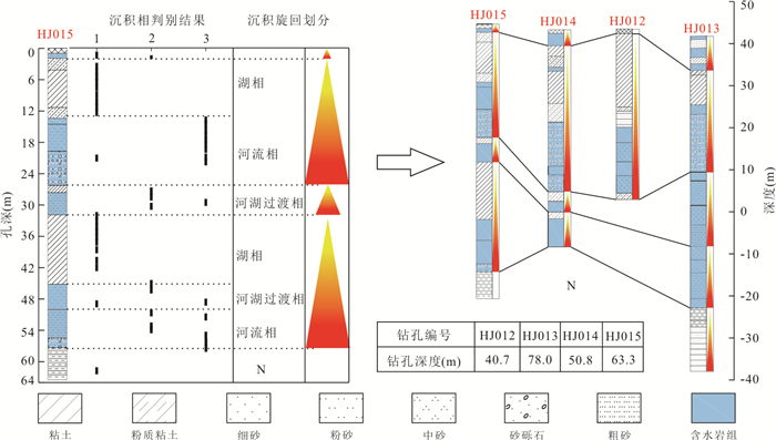
2020, 45(11): 4254-4266.
doi: 10.3799/dqkx.2019.291
Abstract:
In order to explore the practicality of the Fisher model in the Quaternary river-lake evolution of the basin, in this paper it takes the particle size data and sedimentary facies of a single borehole in the upper reach of the Hanjiang River in the Jianghan basin as the training samples of the model, which is calculated by Fisher's basic principle. Then the river-lake phase discrimination model is used to analyze the sedimentary environment evolution of the study area by using the model discrimination results. According to the one-way variance and the significance analysis results, the Fisher model has a good distinguishing effect on the river phase, the river-lake transition phase, and the lake phase. The leave-one-out-cross-validation result reaches 80.6%, exceeding the 75% standard required for the discriminant model application. At the same time, the results of the quantitative evaluation of porous sedimentary facies are compared with the qualitative classification results, and the comprehensive coincidence rate reaches 85.06%, which further verifies the practicality of the Fisher model in the identification of rivers and lakes. According to the results of discriminant analysis, since the Early Pleistocene, there are four large sedimentary cycles in the study area, which can be divided into eight sedimentary stages. The hydrodynamic sources are complex and changing rapidly in different sedimentary stages, and the regional sedimentary environment evolution and Neotectonic movement are consistent. This study demonstrates that it is feasible to establish Fisher model based on particle size data for analyzing sedimentary facies and sedimentary environment, and enrich the sedimentary environment data of Hanjiang Section of Jianghan basin. It provides an important reference for basin water resources investigation and protection.
In order to explore the practicality of the Fisher model in the Quaternary river-lake evolution of the basin, in this paper it takes the particle size data and sedimentary facies of a single borehole in the upper reach of the Hanjiang River in the Jianghan basin as the training samples of the model, which is calculated by Fisher's basic principle. Then the river-lake phase discrimination model is used to analyze the sedimentary environment evolution of the study area by using the model discrimination results. According to the one-way variance and the significance analysis results, the Fisher model has a good distinguishing effect on the river phase, the river-lake transition phase, and the lake phase. The leave-one-out-cross-validation result reaches 80.6%, exceeding the 75% standard required for the discriminant model application. At the same time, the results of the quantitative evaluation of porous sedimentary facies are compared with the qualitative classification results, and the comprehensive coincidence rate reaches 85.06%, which further verifies the practicality of the Fisher model in the identification of rivers and lakes. According to the results of discriminant analysis, since the Early Pleistocene, there are four large sedimentary cycles in the study area, which can be divided into eight sedimentary stages. The hydrodynamic sources are complex and changing rapidly in different sedimentary stages, and the regional sedimentary environment evolution and Neotectonic movement are consistent. This study demonstrates that it is feasible to establish Fisher model based on particle size data for analyzing sedimentary facies and sedimentary environment, and enrich the sedimentary environment data of Hanjiang Section of Jianghan basin. It provides an important reference for basin water resources investigation and protection.