2025 Vol. 50, No. 9
 PDF 343KB
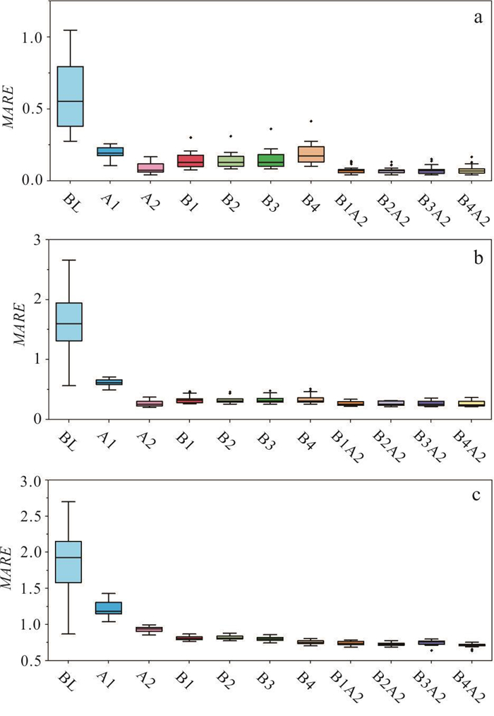
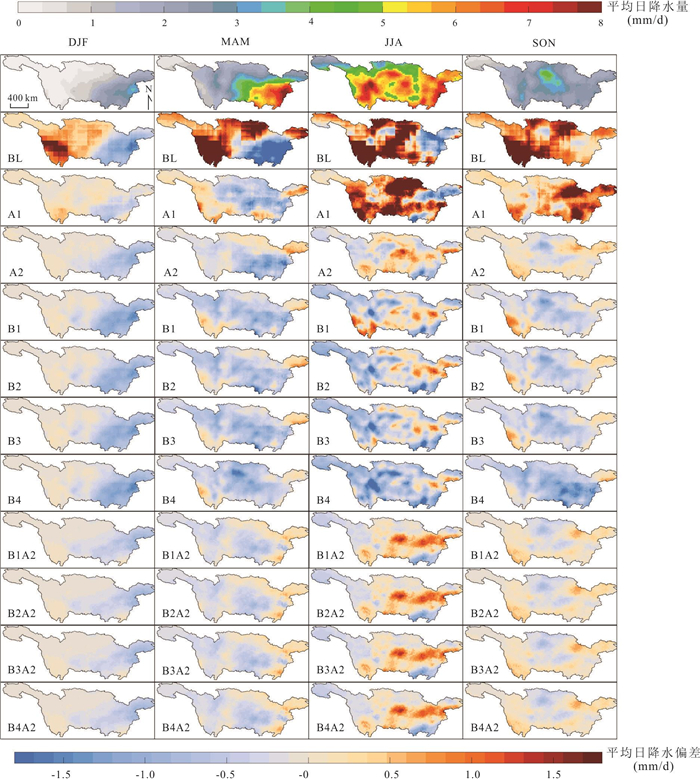
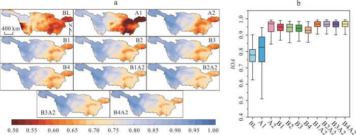
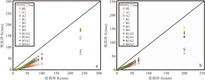
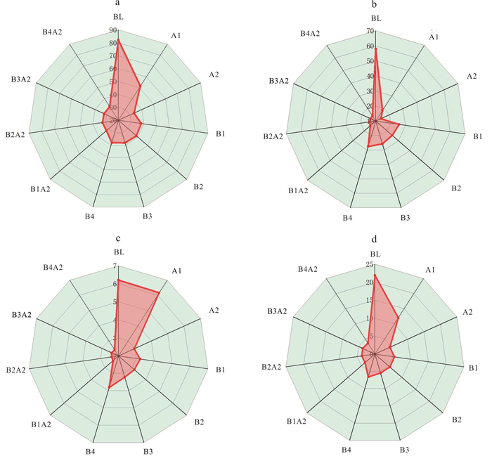
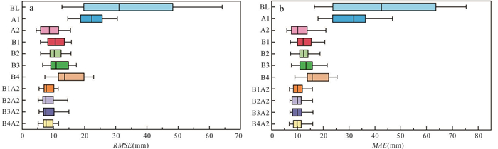
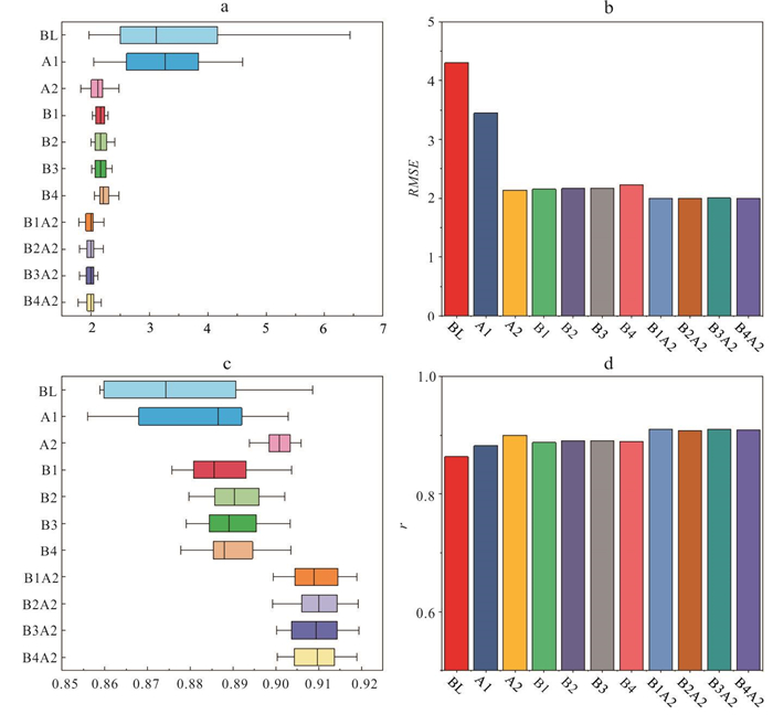
To improve the downscaling effectiveness of deep learning methods for daily precipitation from global climate models (GCMs). Targeting at the Yangtze River basin, we constructed four deep learning downscaling models based on historical daily precipitation outputs from 20 GCMs. A hybrid method (DL-DBC) was proposed by integrating these models with the daily bias correction method. The four deep learning models exhibited comparable performance in daily precipitation downscaling. Compared to DBC, they achieved lower mean absolute relative error (MARE) for multi-year average daily precipitation but slightly higher MARE for multi-year average monthly and annual precipitation. The DL-DBC method outperformed standalone deep learning models, reducing MARE for multi-year average annual precipitation by 6.7%-11.3% and monthly precipitation by 6.3%-7.6%, while also demonstrating superior performance in precipitation frequency analysis. The DL-DBC method enhances the downscaling effectiveness of deep learning models and further reduces biases in daily precipitation data from GCMs.
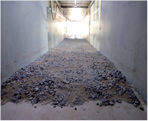
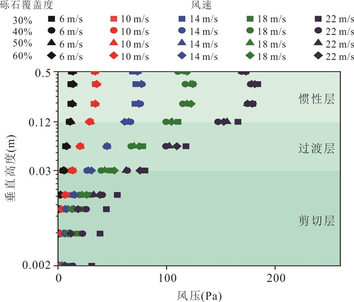
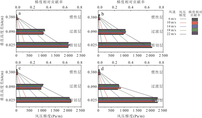
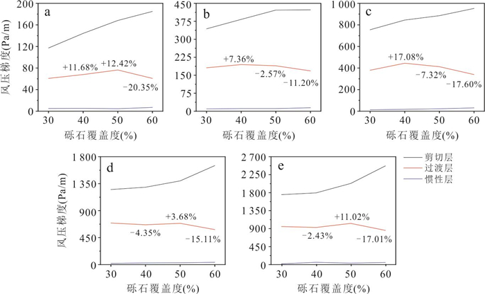
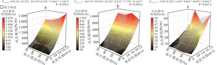
The Gobi Desert is a critical source area for cross-border dust transport, where the interaction between surface gravel coverage and the near-surface wind pressure gradient exerts a significant influence on the dust emission mechanism. Through two-phase flow wind tunnel experiments, the near-surface wind field characteristics of the Gobi were simulated. Nonlinear regression models and two-factor analysis were employed to reveal the regulatory mechanisms. (1) The wind pressure increase exhibits stratified variation, with the wind pressure gradient decaying linearly or exponentially with increasing height. (2) Gravel coverage significantly regulates the vertical differentiation of the wind pressure gradient. (3) Incoming wind speeds directly controls the intensity of the wind pressure gradient, while gravel coverage induces energy absorption and momentum transfer. Surface heterogeneity in the Gobi Desert dynamically regulates wind pressure gradient through the interplay between near-surface roughness and wind forces. Maintaining optimal gravel coverage (40%-50%) effectively balances aeolian erosion control and momentum transfer, providing a mechanistic foundation for refining dust emission models and developing precision windbreak-sand stabilization strategies in arid ecosystems.
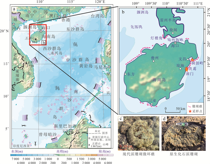
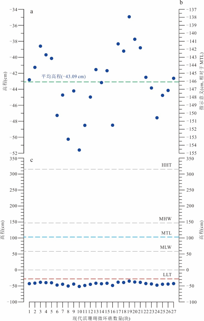
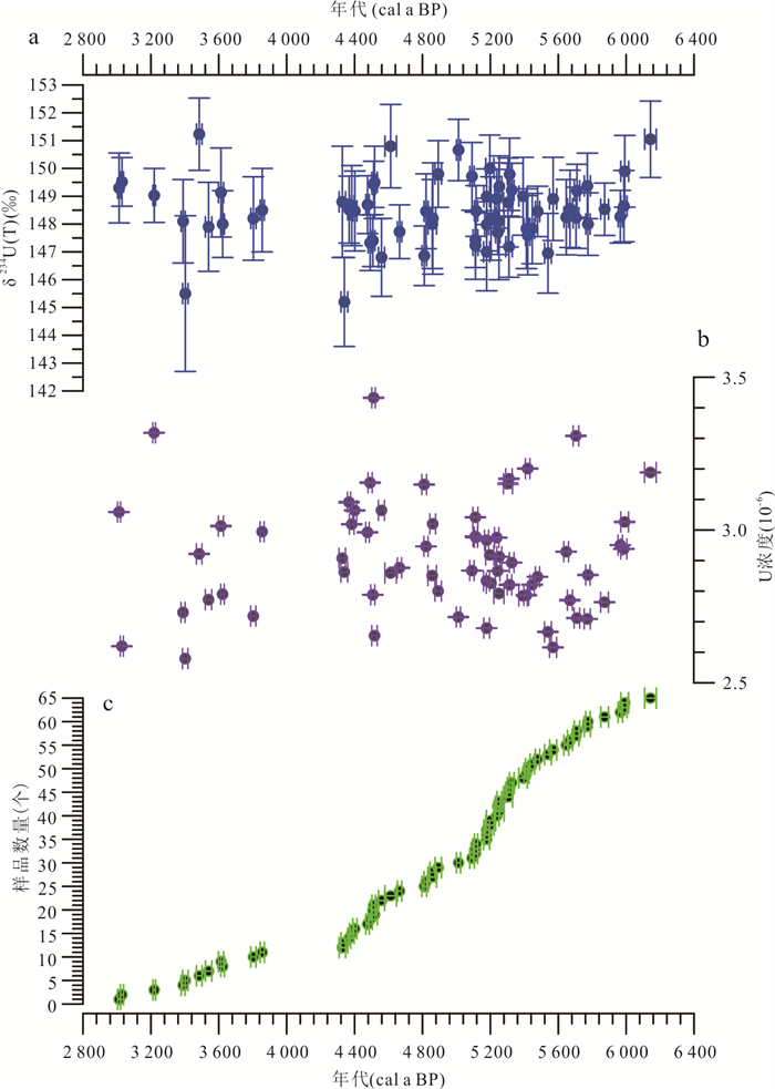
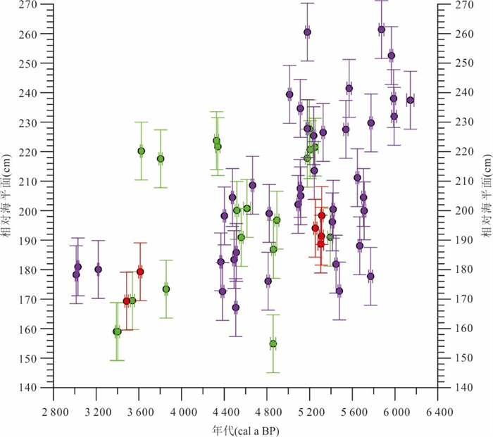
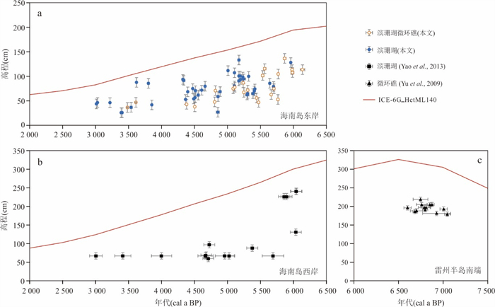
The coral reefs along the Leiqiong Coast in the northern part of the South China Sea are key indicators for studying paleo-sea level changes. However, due to the lack of unified standards, significant spatiotemporal discrepancies exist in coral-derived sea-level data. In this study, through field measurements of the top surface elevation of 27 modern Porites microatolls in the coral reef area of eastern Hainan Island, the sea level indicative meaning of Porites microatolls was first precisely quantified. Meanwhile, 65 published sea-level index proxies based on U-Th dated fossil Porites (microatoll) corals from the region were systematically recalibrated and integrated to reconstruct a more accurate and reliable sea-level change history during the Middle Holocene in the northern South China Sea. The research reveals that those modern Porites colonies with dead upper surfaces but intact overall viability have reached their growth limits. Their top elevation lies 146.09 cm below the mean tide level of Qinglan Port and 15.09 cm below the lowest low tide, and the height difference of the growth limit is only ±8.35 cm, representing a typical developmental pattern of Porites microatolls. It is confirmed that their growth limits are primarily controlled by the lowest low tide level, and they are ideal indicators for reconstructing past sea levels. Sea level reconstruction results indicate that the relative sea level in the northern South China Sea exhibited a fluctuating downward trend from (6 143±34) cal a BP to (3 013±9) cal a BP, ranging from (25.0±9.8) cm to (136.09±9.80) cm. Comparison with sea level records from surrounding South China Sea regions reveals spatiotemporal variations in the timing and magnitude of Middle Holocene high sea-level, which may be attributable to differences in indicator elevation estimation methods and dating techniques. In addition, a comparison of the research results with the sea level predicted by the GIA model (ICE-6G_HetML14), reveals that the Middle and Late Holocene sea-level data at three locations along the Leqiong coast are all below the model curve. This indicates that these regions may have undergone tectonic subsidence over the past several thousand years. The results of this study offer an important scientific basis for predicting the future sea-level change trend in the northern South China Sea, and provide a new perspective on regional tectonic evolution studies.
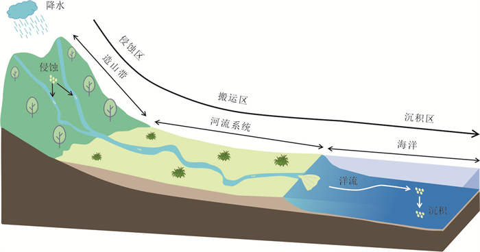
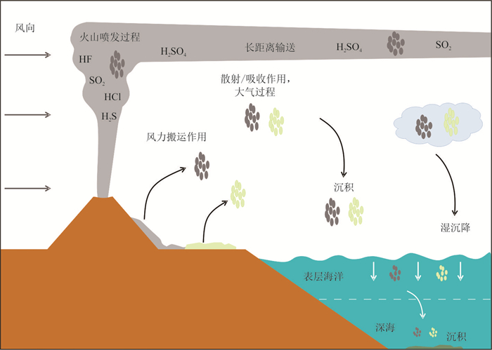
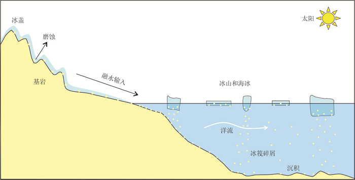
The source-to-sink process in marine sediments is a critical link connecting terrestrial weathering, oceanic dynamics, and global climate change, playing a vital role in reconstructing paleoenvironmental evolution. This paper reviews the transport processes of terrestrial and volcanic materials to the ocean and their control mechanisms. The transport of terrestrial materials is regulated by the lithology-climate-sea level-current system: the nature of the source rocks and climate conditions determine the output and physicochemical properties of the sediments by controlling weathering; sea level changes dominate the distance of sediment transport; and the current pattern determines the final distribution of the sediments. The input of volcanic materials is controlled by the intensity of volcanic activity, climate, hydrology and regional tectonic context. Recent advances in geochemical and mineralogical provenance techniques have significantly improved the identification capacity of sediment sources. However, this field still faces methodological challenges in transitioning from qualitative assessments to quantitative reconstructions. Future research should focus on developing integrated, multidisciplinary approaches to enhance our understanding of the evolution of marine sedimentary source-to-sink systems.
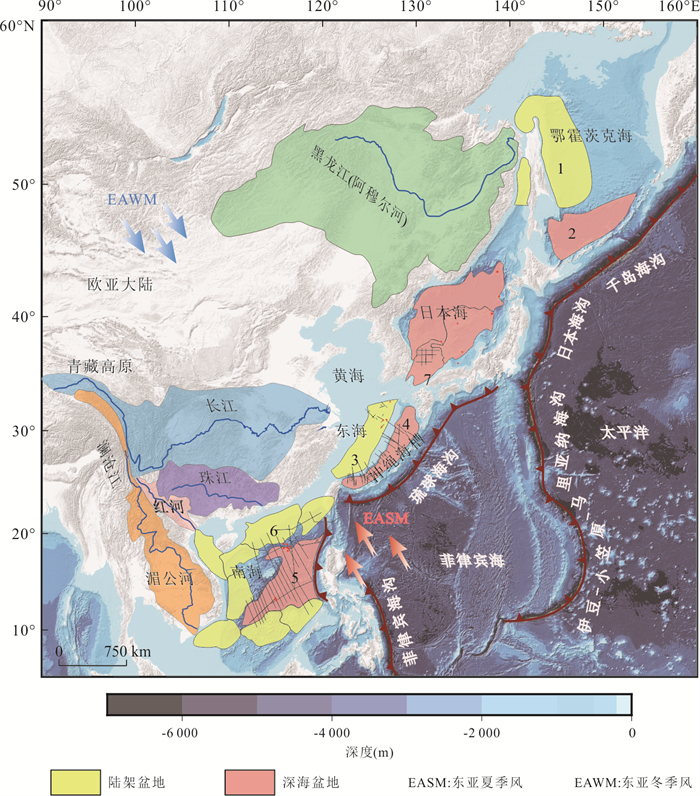
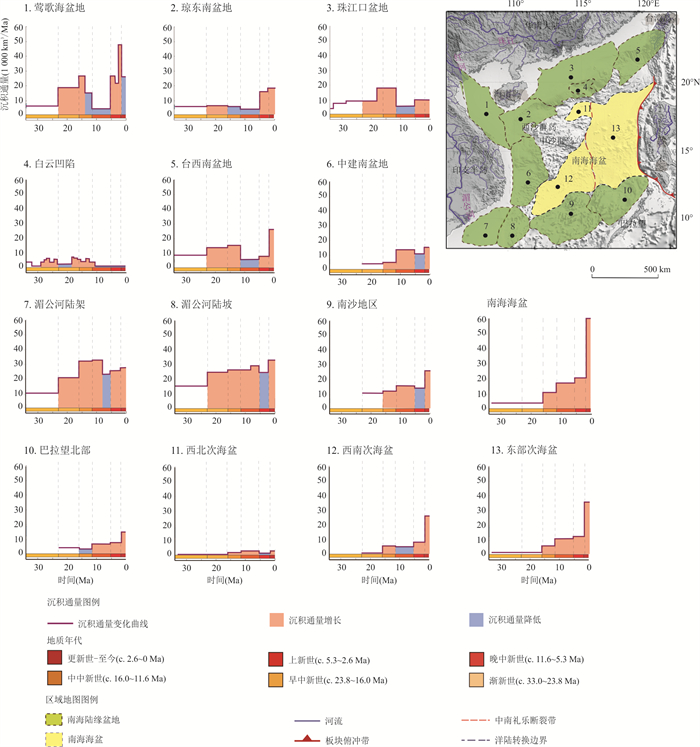
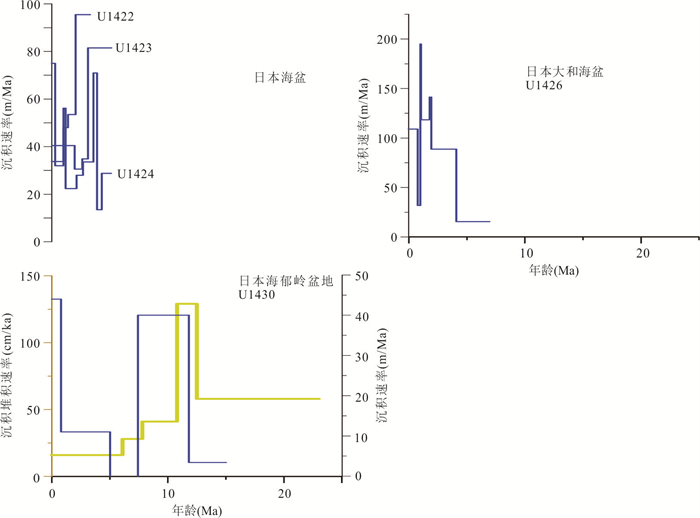
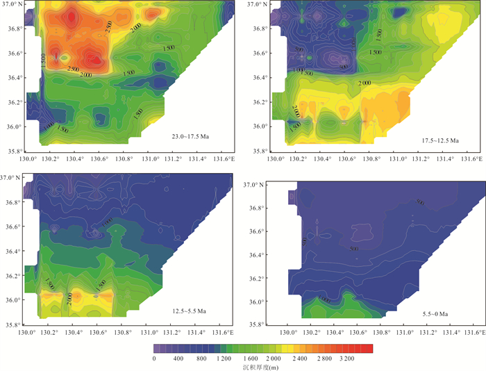
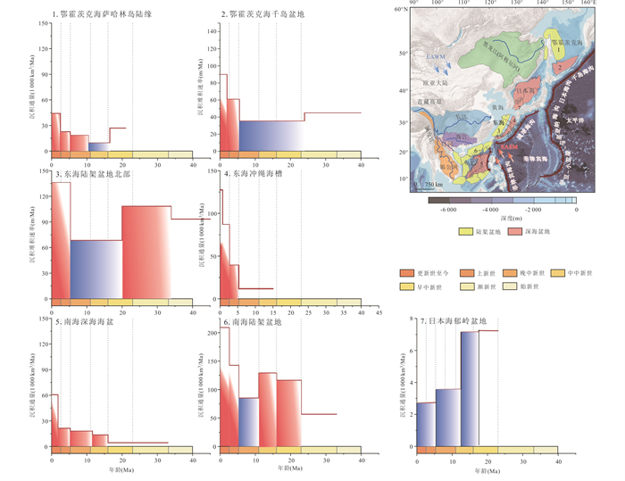
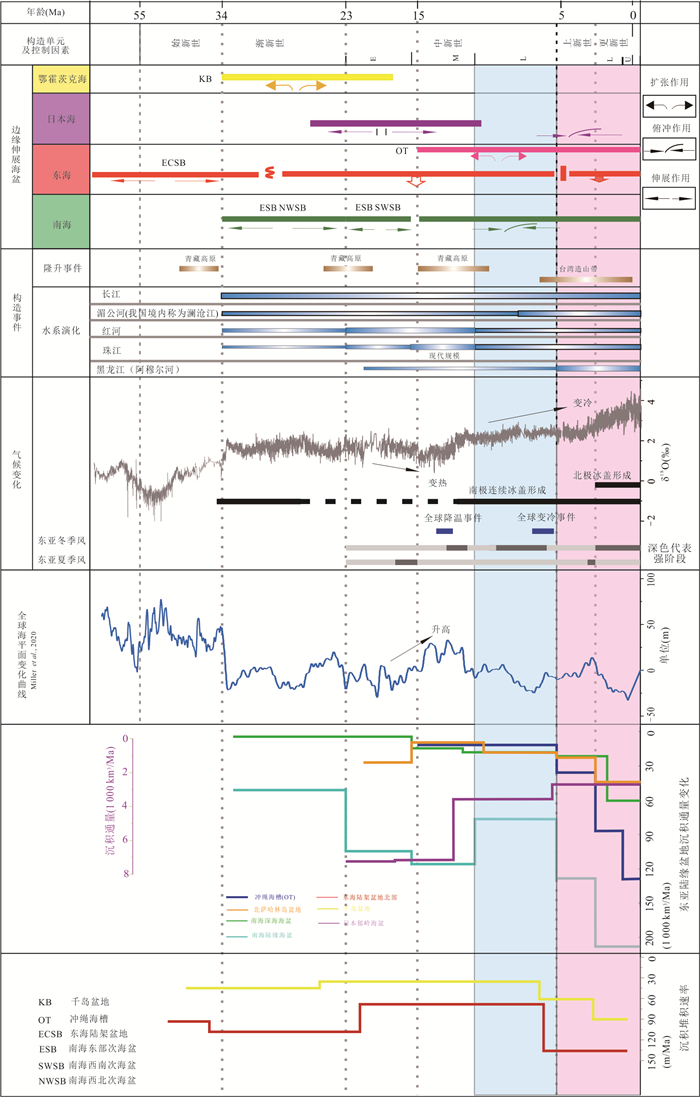
The East Asian continental margin located at the convergent and collisional boundary of the Pacific Plate and the Eurasian Plate, is not only the most tectonically and climatically active region in the world, but also an important place of the sedimentary "source to sink" process since the Cenozoic, However, the sedimentary dynamic processes and key controlling factors of basins at different latitudes remain unclear. This study calculates and statistically analyzes Cenozoic sedimentary flux in high-latitude (Okhotsk Sea), mid-latitude (Japan Sea, East China Sea), and low-latitude (South China Sea) basins. It is found that the evolution of sedimentary flux along the East Asian continental margin shows pronounced latitudinal differentiation: Mid- to Low-latitude basins (South China Sea, East China Sea, and Japan Sea) are primarily influenced by the coupling of tectonics, East Asian monsoon, and river systems. During the Late Miocene (11.6-5.3 Ma), the uplift of the Tibetan Plateau resulted in river reorganization and the intensification of the East Asian winter monsoon, reducing sedimentary flux by approximately 1/3 compared to the Middle Miocene. Since the Pliocene (5.3-0 Ma), the strengthening of the East Asian summer monsoon and the uplift of Taiwan Island increased it by 2 to 3 times compared to the Late Miocene, while the Japan Sea was mainly controlled by monsoon and local tectonics. High latitudes basin (Okhotsk Sea) is subject to the synergy of tectonics and glaciation. During the Middle to Late Miocene (16.0-5.3 Ma), global cooling events caused a decline in sedimentary flux by approximately 60% compared to the Early Miocene. Since the Pliocene (5.3-2.5 Ma), the expansion of the Heilongjiang River (Amur River) basin and the uplift of Sakhalin Island have led to an approximately 2-fold increase in sedimentary flux.
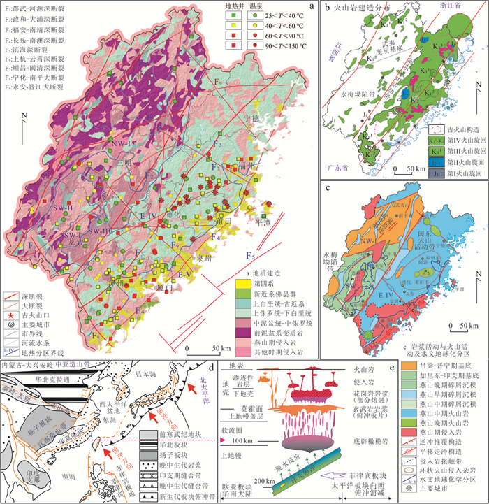
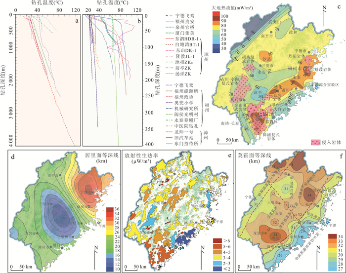
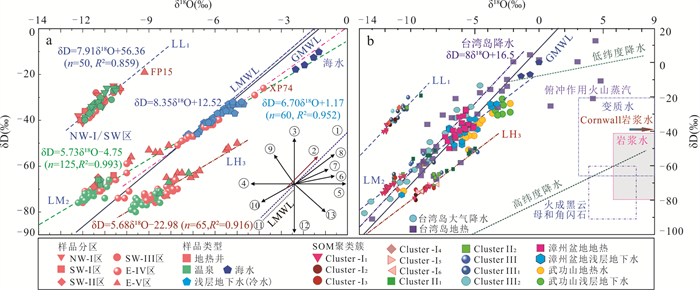
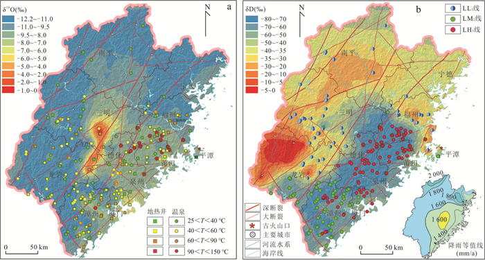
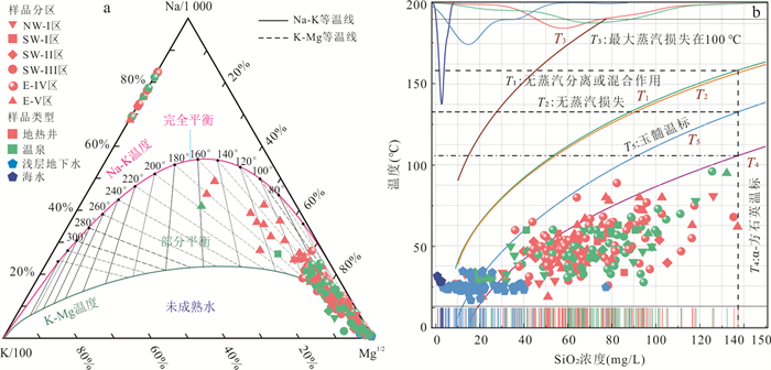
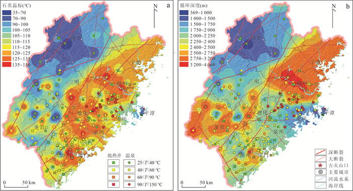
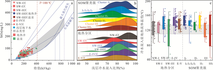
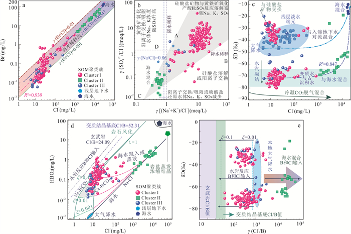
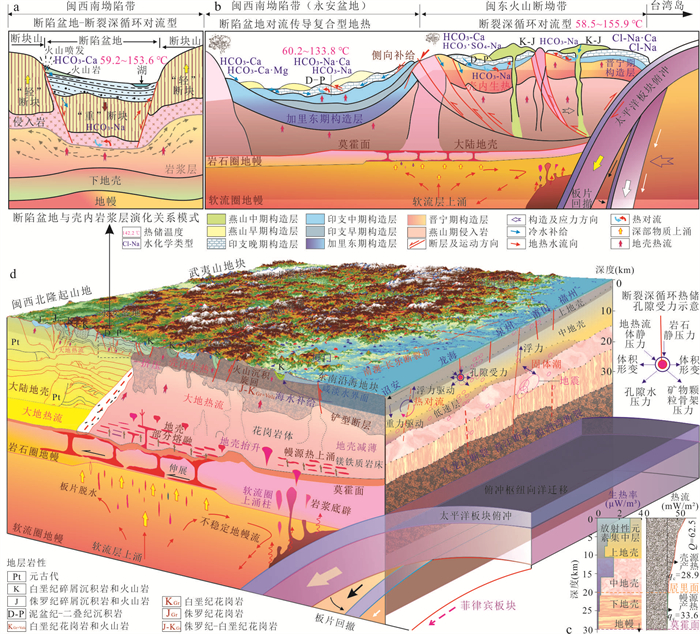
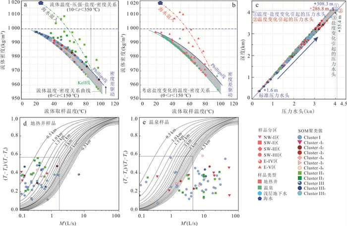
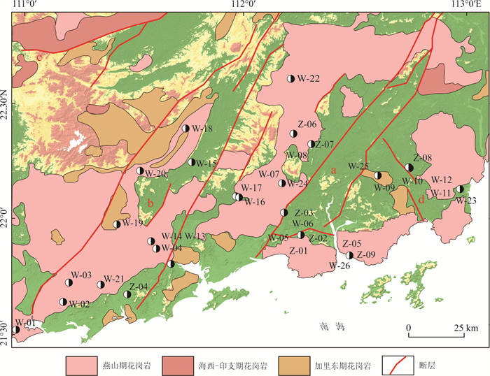
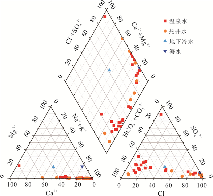
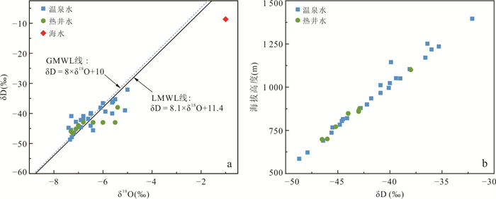
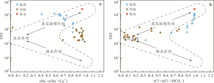
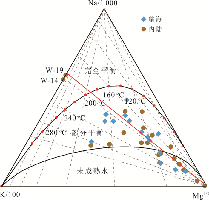
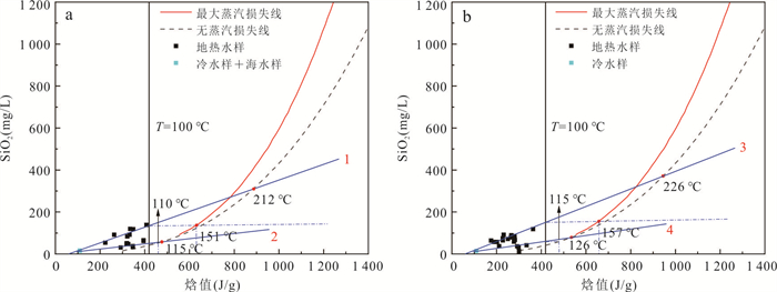
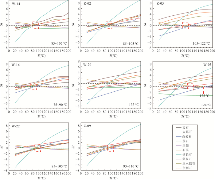
Fujian Province is one of the most important geothermal anomaly areas in the southern margin of China. It is of great significance for the scientific utilization of geothermal resources to reveal the formation mechanisms of geothermal system in the area. The circulation and evolutionary characteristics of geothermal fluid were clarified, and the conceptual formation mode and driving force of hydrothermal system were established in each hydrogeochemical zone based on the implications of hydrochemical and isotopic characteristics of geothermal water samples, GIS spatial analysis, and the overview of regional geothermal geological and crustal thermal structure conditions. The results show that the geothermal system in Fujian Province can be divided into deep circulation convection type of uplifted mountain faults in northwestern region, complex convection conduction hydrothermal type of fault basin in southeastern region, and deep circulation convection type of fault depression zone in eastern and southeastern region. The endowment of geothermal resources in Fujian is controlled by regional tectonics and crustal thermal structure that the geothermal systems of Wuyi uplift zone in western Zhenghe-Dapu fault and the coastal margin zone in eastern Fujian obtained different crust and mantle heat source compositions, but relatively uniform hydrothermal transmission channels. The heat accumulation of the geothermal system in the Wuyi uplift zone is mainly derived by mantle conduction, while the lithospheric thermal structure of eastern volcanic depression zone is the "hot crust-cold mantle" type in which radioactive element decay of intrusive-volcanic rock mass contributed a relatively high amount of crustal heat accumulation. The regional tensile torsional NW faults turned out to be the water conducting channels of geothermal systems, while compression-dominated NE-trending faults were the water-blocking and heat-conducting channels for heat accumulation. The standard head of total geothermal driving force generated by temperature rise and salinity increase in hydrothermal system of northwestern, southwestern, eastern volcanic depression zone and coastal margin region was +218.75 m, +202.24~+250.60 m, +261.72 m and +308.32 m respectively. The Yongmei depression zone in western Fujian, and intersection zones of regional NW and NE deep faults, namely the hydraulic fracture of the faulted basin and the sunken bay extend deep into the mainland, the basement uplift zone of fault basins such as Fuzhou and Zhangzhou basins, intersection zones of regional NE deep faults and ring-shaped volcanic apparatus in eastern Fujian were the optimal target areas for exploitation of medium-high temperature geothermal resources in bulk.
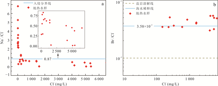
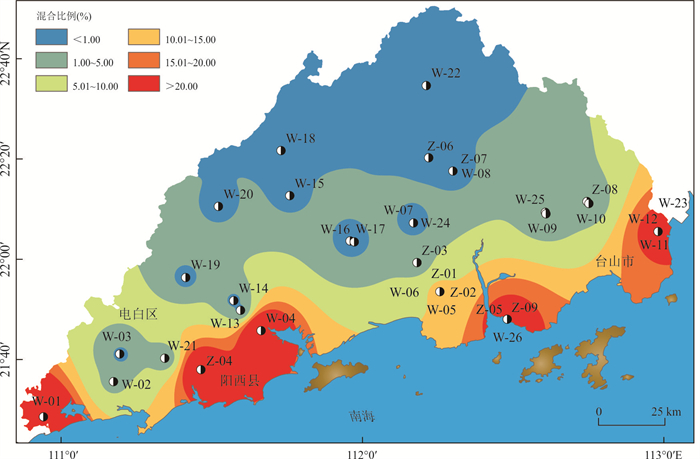
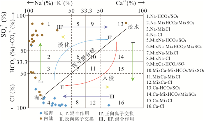
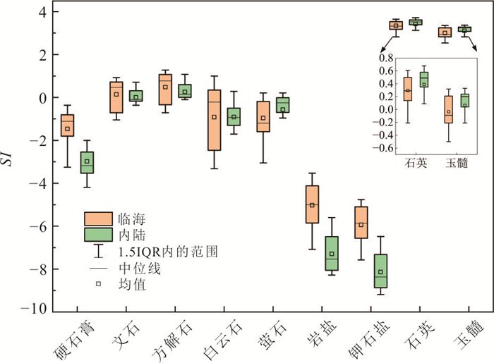
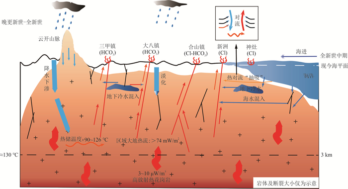
Coastal geothermal systems are prone to seawater intrusion, which can increase the salinity of geothermal water, reduce its utilization efficiency, and raise operational costs. As a significant region for medium-low temperature geothermal resources in China, the coastal areas of Guangdong Province still lack systematic research on seawater intrusion into geothermal systems and its impacts. This study investigates the hydrochemical characteristics, seawater intrusion extent and formation mechanisms based on physicochemical data from 35 geothermal water samples, one cold groundwater sample and one seawater sample in western Guangdong Province. Comprehensive analyses including hydrochemistry, isotopes and multivariate graphical interpretation methods, are employed to explore these aspects. The research results indicate that coastal geothermal water exhibits visible seawater intrusion characteristics with high salinity levels, demonstrating a maximum mixing proportion reaching 41.88%. The hydrochemical types evolve from bicarbonate-type in inland areas to chloride-type in coastal zones. The geothermal water is primarily recharged by atmospheric precipitation. During the Late Pleistocene to Holocene period, infiltrated meteoric water from the Yunkai Mountain and Tianlu Mountain areas interacted with geothermal reservoir rocks at a temperature of 90-126 ℃, undergoing gradual temperature elevation. Subsequently, marine transgression events induced large-scale paleo-seawater mixing into the geothermal system, where seawater migration was accelerated by thermal convection "pumping effects". Thereafter, sustained seawater intrusion has persistently affected coastal areas, ultimately forming medium-low temperature geothermal water with high salinity characteristics.
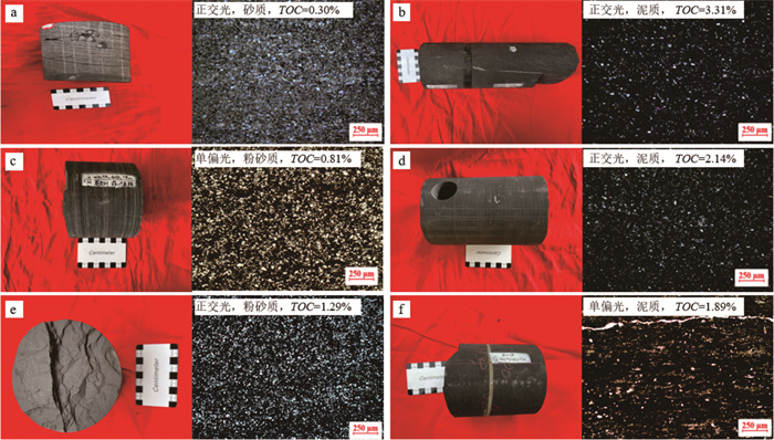
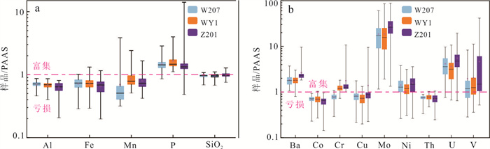
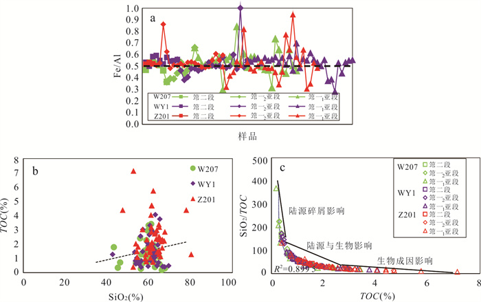
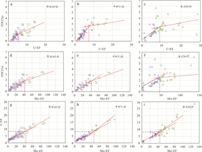
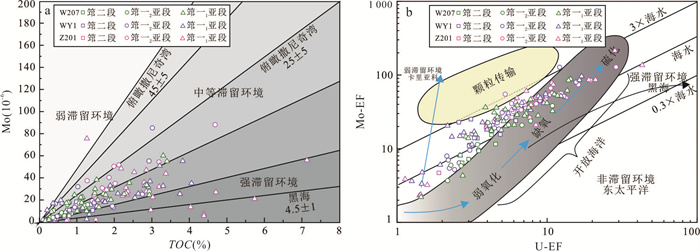
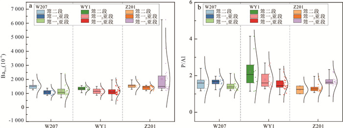
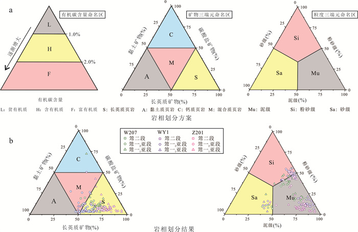
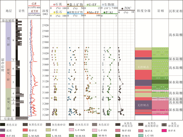
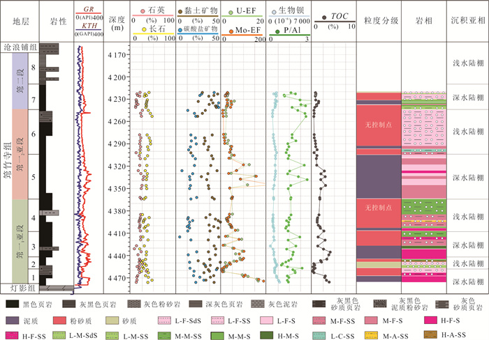
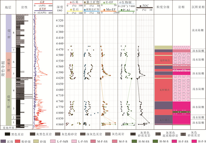
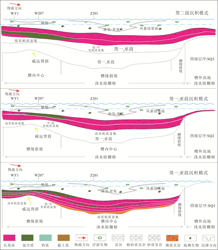
The sedimentation of the Qiongzhusi Formation shale in the Sichuan Basin is controlled by the tectonic-sedimentary differentiation of the Deyang-Anyue Rift Trough. Its lithofacies types and distribution are closely related to sedimentary environments. Based on previous studies of the Qiongzhusi Formation, this research comprehensively uses core observation, thin-section identification, and geochemical testing and analysis to classify the lithofacies types of the Qiongzhusi Formation shale in the middle segment of the rift trough, and discusses the high quality shale lithofacies types and their distribution controlled by sedimentary environments. The results show that: (1) The sedimentary environment within the rift depression exhibits distinct differentiation characteristics. The central part of the depression is dominated by biogenic high-silica deposits, forming a strong reducing environment with a dual-threshold boundary, where ancient productivity and water retention reach their peak; the trough margin is dominated by terrigenous clastic input. Horizontally, it shows a gradational pattern of "oxidizing margin-anoxic trough, " while vertically, it exhibits a cyclic evolution of " anoxic at the bottom-dysoxic in the middle-oxidizing at the top." (2) "TOC-mineral-grain size" coupling lithofacies classification system is established, with 36 lithofacies types divided. It is clarified that 16 lithofacies types develop in the middle segment of the rift trough, such as organic-rich felsic shale (H-F-S) and organic-rich mixed silty shale (H-M-SS), systematically revealing the heterogeneity characteristics of shale and providing new ideas for predicting deep shale gas sweet spots. (3) The high-quality lithofacies are mainly organic-rich felsic shale (H-F-S), organic-rich mixed shale (H-M-S), organic-rich felsic silty shale (H-F-SS), organic-rich argillaceous silty shale (H-A-SS), and organic-rich mixed silty shale (H-M-SS), which are concentrated in the deep-water shelf facies of the 1st, 3rd, 5th, and 7th sub-layers of the Qiongzhusi Formation. The deep-water dysoxic-anoxic environments promote organic matter enrichment and preservation, and high felsic mineral content provides high-quality reservoir spaces. The research results provide key geological bases for the evaluation and development of deep shale gas resources in the Sichuan Basin.
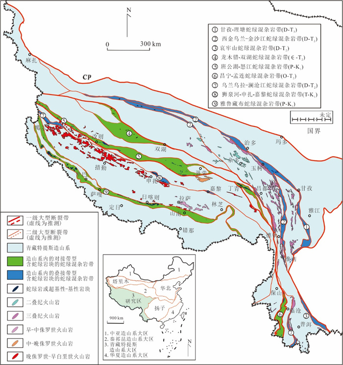
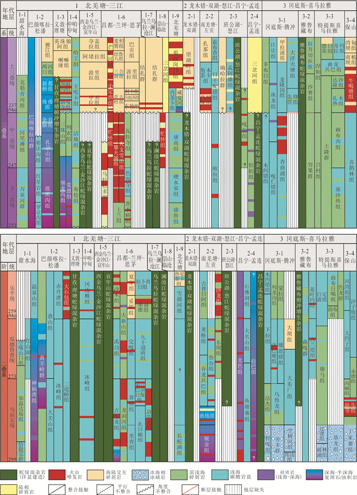
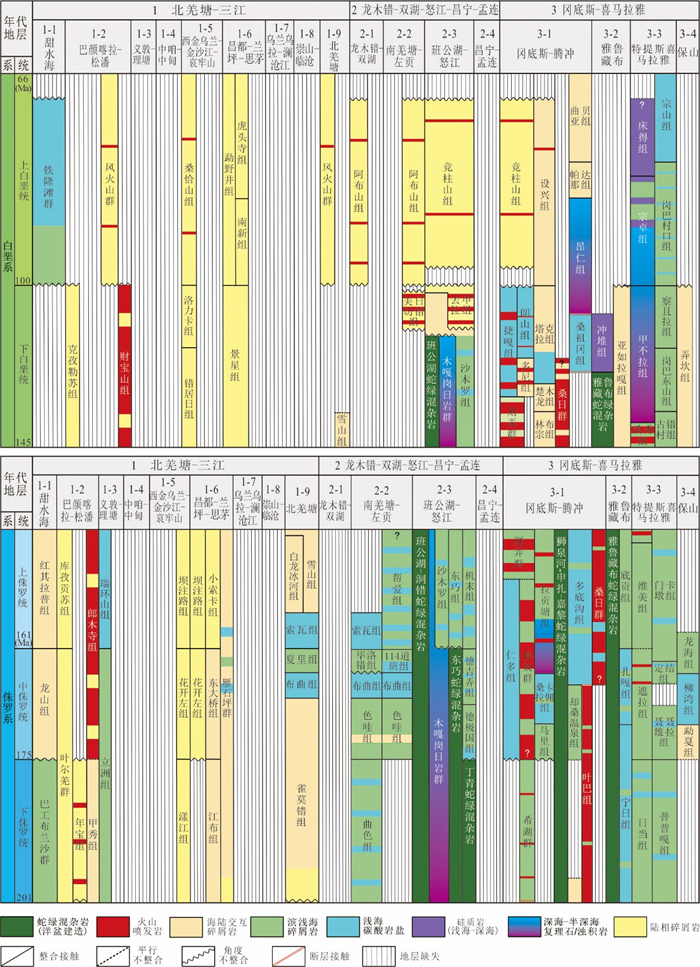
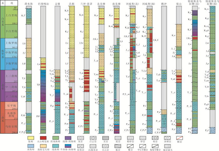
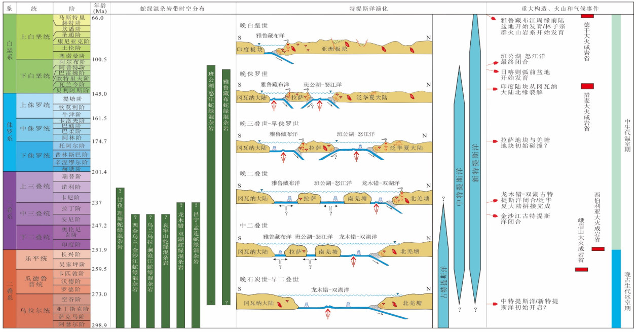
The Late Paleozoic-Mesozoic (Permian-Cretaceous) was a crucial period for major reorganization of the tectonic-paleogeographic pattern of the Tethyan Qinghai-Xizang Plateau. Three first-order tectonic-stratigraphic units (super-realms) and seventeen second-order tectonic-stratigraphic units (realms) have been devised. Through detailed research of lithostratigraphic unit and its characteristics of sedimentary background and contact-correlation relationship for the continental blocks and their closely associated continental arcs, forearc basins, marginal sea basins, micro-continents etc. In each tectonic-stratigraphic units, we have finally established the Late Paleozoic-Mesozoic ocean plate stratigraphy (OPS) framework for the Tethyan Qinghai-Xizang Plateau. In particular, the spatiotemporal distribution of the ophiolite mélange zones in different tectonic-stratigraphic units are highlighted. By systematically researching the temporal-spatial features of the ophiolite mélange zones and their associated island arc-basin systems in Tethyan Qinghai-Xizang Plateau, we reviewed the evolution history of the Paleo-Tethys Ocean (Longmuco-Shuanghu Ocean, Changning-Menglian Ocean), the Meso-Tethys Ocean (Bangong-Nujiang Ocean) and Neo-Tethys Ocean (Yarlung Zangbo Ocean), thus revealing the evolution process of the Late Paleozoic-Mesozoic tectonic-paleogeographic pattern of the Tethyan Qinghai-Xizang Plateau.
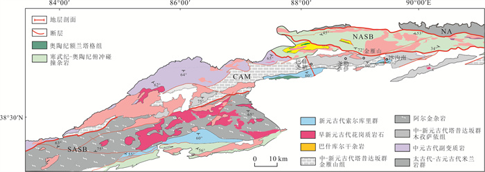
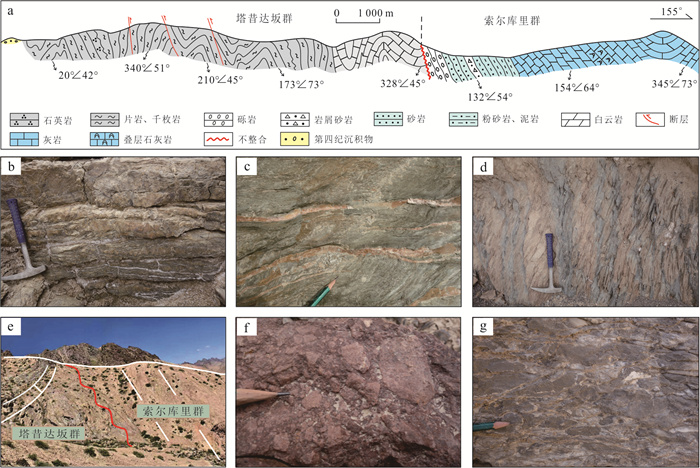
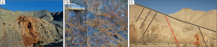
To elucidate the Meso-Neoproterozoic tectonic evolution associated with the amalgamation and breakup of the Rodinia supercontinent in the Altyn Tagh Orogenic Belt, the field geological mapping is conducted and the structural analysis is carried out on the Taxidaban Group (1 080-950 Ma) and Suoerkuli Group (~930 Ma) in the region. The results show that the Taxidaban Group comprises low greenschist-facies para-metamorphic rocks subjected to three phases of deformation: (1) The D1 phase is characterized by pervasive schistosity S1 transposing primary bedding S0; (2) the D2 phase developed WNW-ESE trending folds and crenulation cleavage S2 under NNE-SSW compression; (3) the D3 phase presents as NW-SE directed thrust faults and upright folds induced by SE-NW compression. The Suoerkuli Group unconformably overlies the Taxidaban Group, exhibiting distinct discontinuities in depositional environments and structural deformation between the two units. Integrating lithological compositions, deformation sequences, and spatiotemporal distribution of early Neoproterozoic magmatic rocks with their tectonic settings, this study proposes that the Altyn region completed a tectonic transition from an active continental margin to post-collisional extension during the late Mesoproterozoic to early Neoproterozoic. The findings provide critical evidence for constraining its relationship with Rodinia supercontinent cycles and paleogeographic affinity.

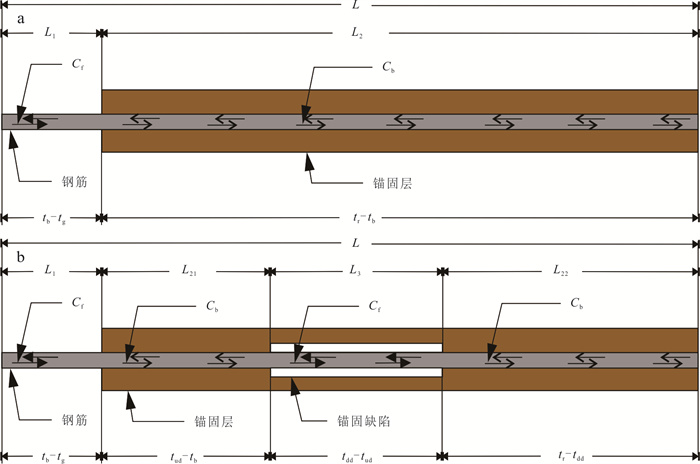
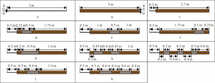
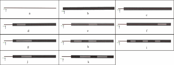
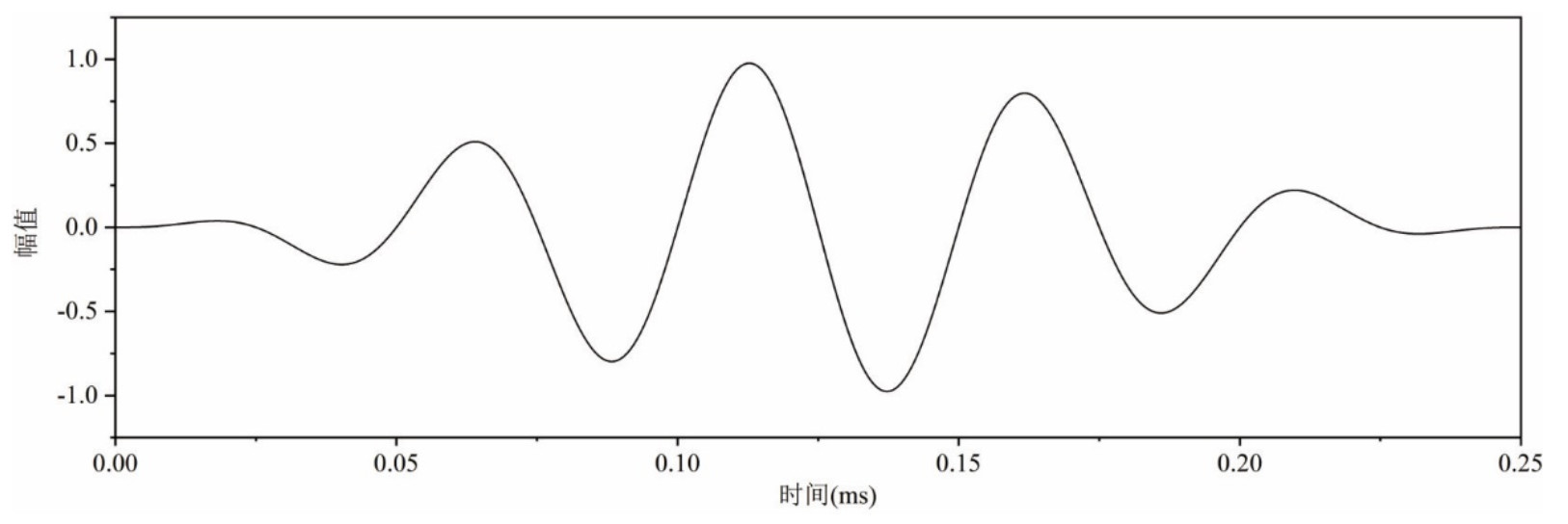
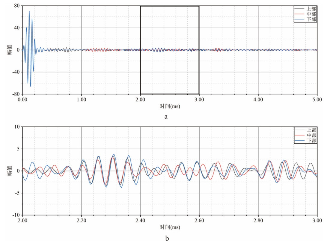
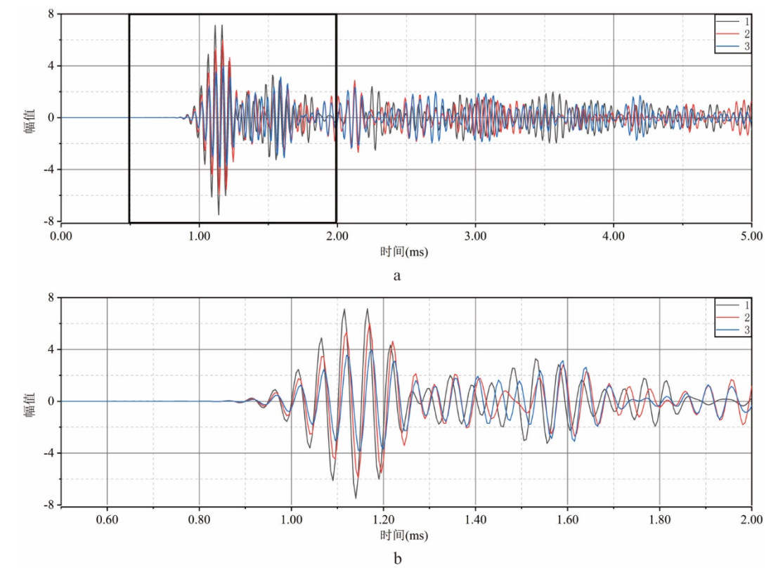
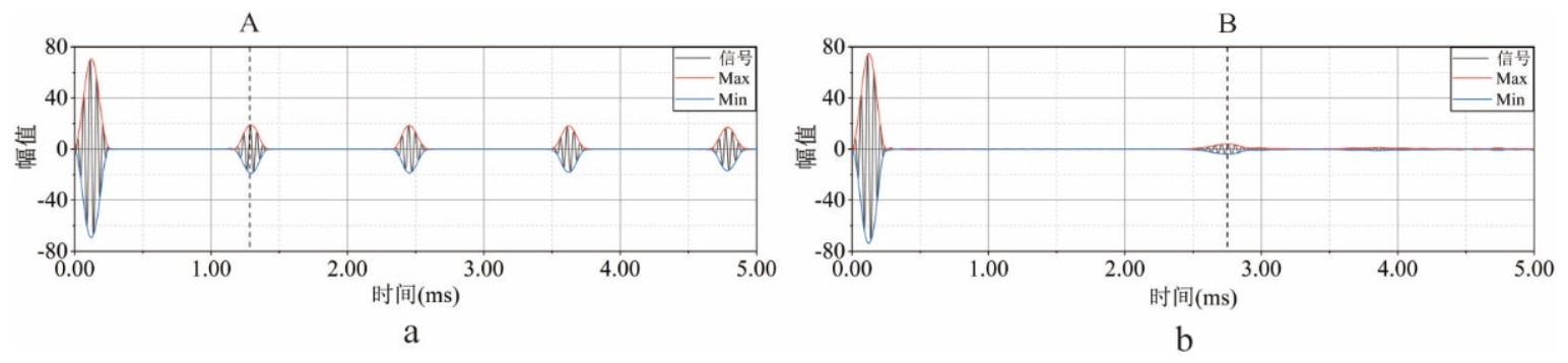
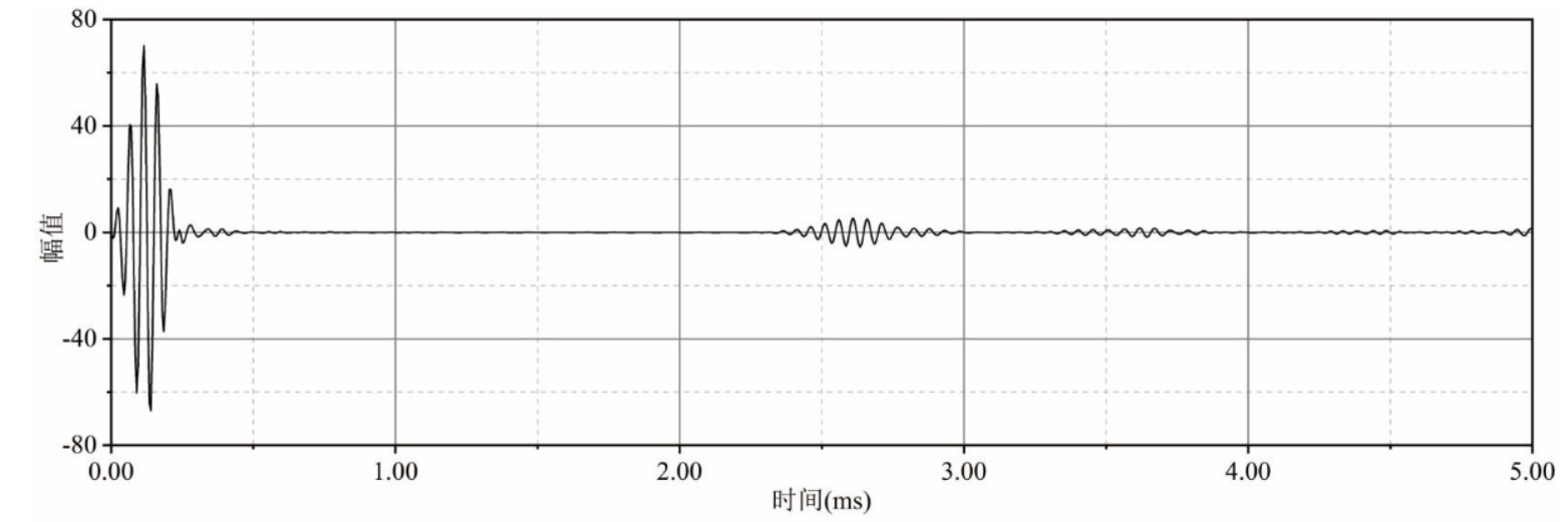
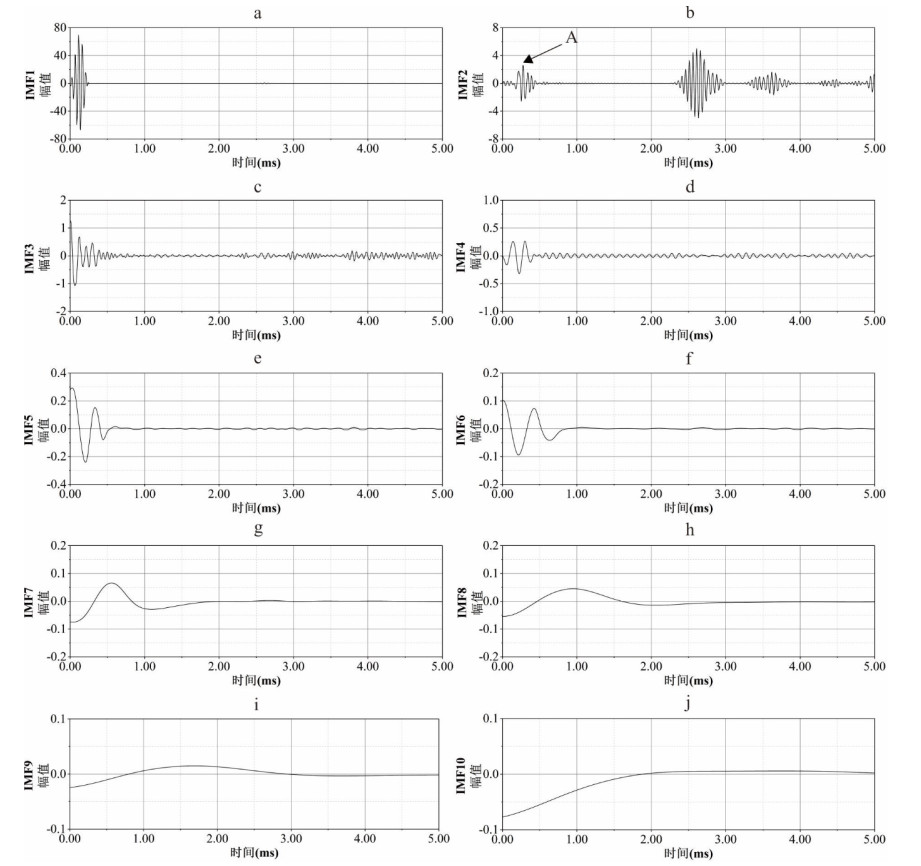
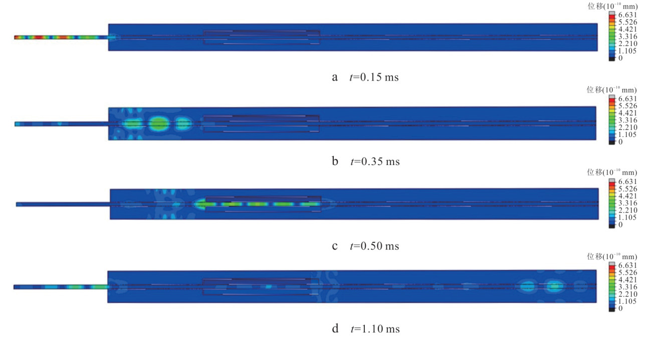
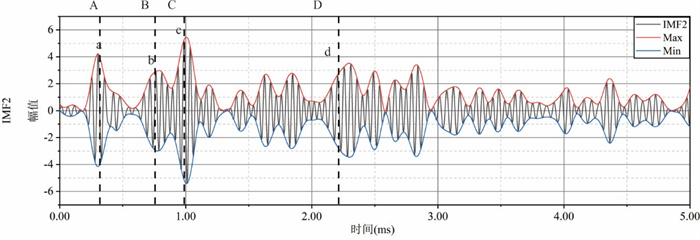
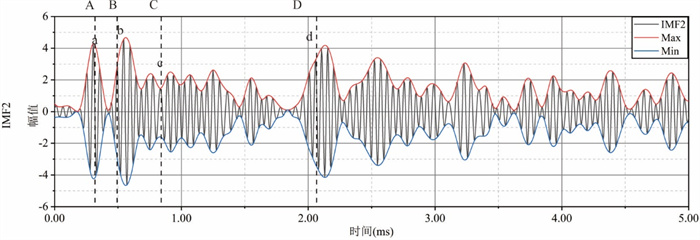
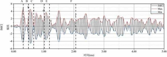
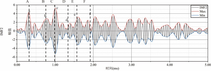
In order to quantitatively detect the internal defects of anchor, it is proposed to use the finite element method to simulate the propagation process of the ultrasonic guided wave in the defective anchor, and to use the improved adaptive noise complete ensemble empirical mode decomposition (ICEEMDAN) method to process the ultrasonic guided wave reflection signal. Then, according to the peak value in the decomposed intrinsic mode function (IMF), the arrival time of the defect reflection wave is obtained, based on which the position and length of the anchorage defects are evaluated. A series of parameter analyses show that the defect location deduced based on the proposed method is in good agreement with the actual situation, and the calculation error of single defect length is within 3.3%, and the calculation error of multiple defect length is less than 10%. Hence, the ultrasonic guided wave method based on ICEEMDAN can be used as an effective means to detect the internal defects of the bolt.
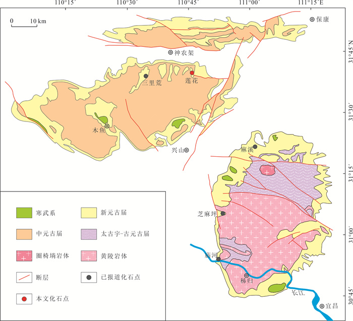
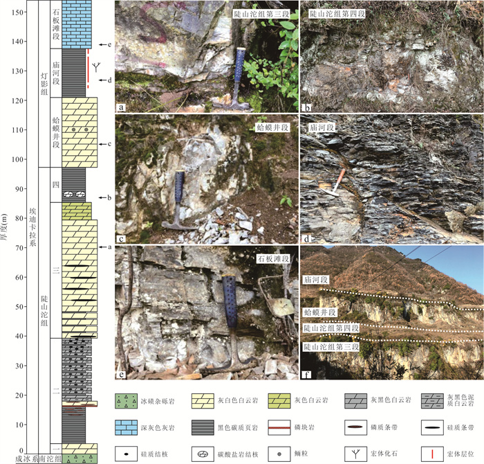
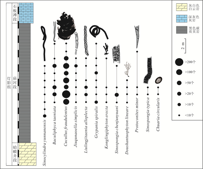
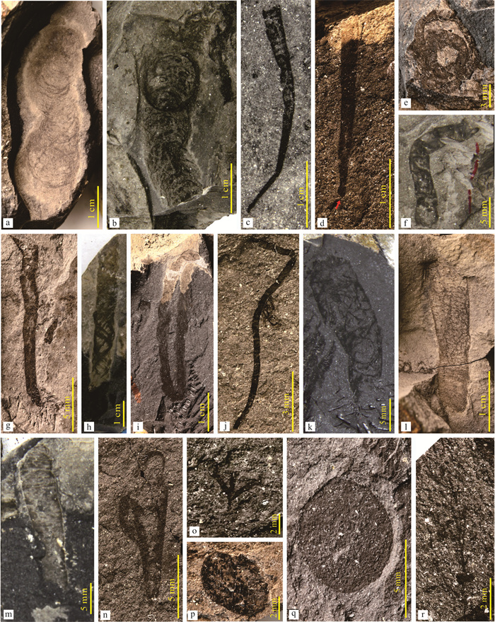
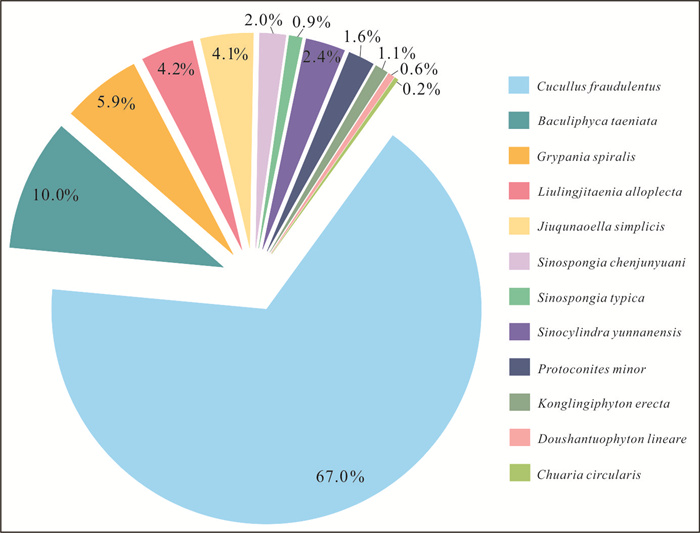
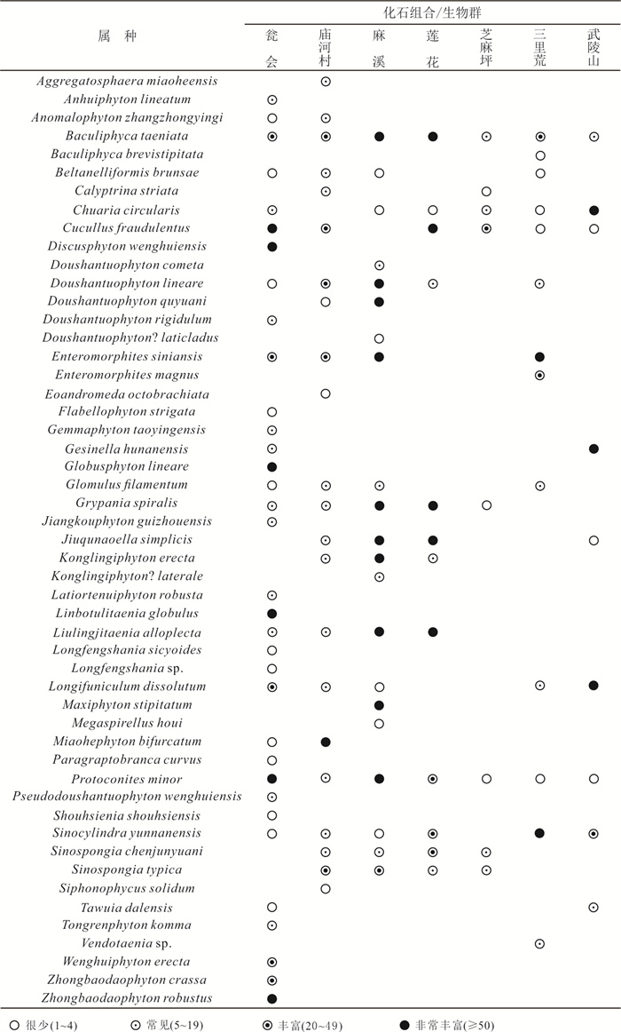
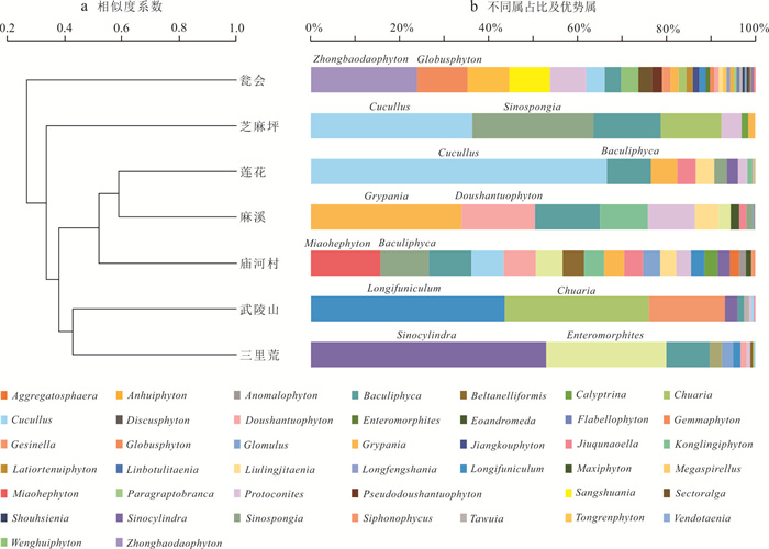
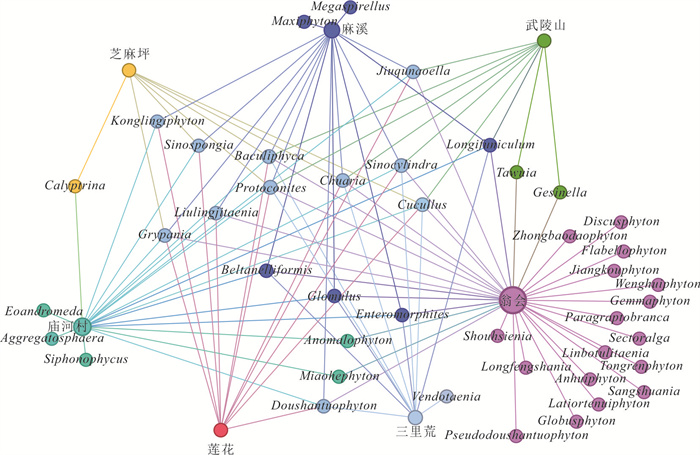
The Ediacaran Miaohe biota is one of the key windows on the evolution and radiation of complex multicellular eukaryotes between the Snowball Earth and the Cambrian Explosion. Recently, several localities of the Miaohe biota have been reported in western Hubei Province, sparking different opinions on its stratigraphic position. In order to better reveal characteristics of the Miaohe biota in different regions/facies, we conducted systematic paleontological analysis on a newly discovered fossil site of the Miaohe biota at the Lianhua section in eastern Shennongjia area. A total of 11 genera and 12 species of macrofossils were identified, including typical fossils previously described in the Miaohe biota, with dominant species being Cucullus fraudulentus, Baculiphyca taeniata and Grypania spiralis. The discovery of the new macrofossil assemblage not only expands the paleogeographic distribution of the Miaohe biota, but also provides significant insights into the evolution of Ediacaran macrofossils in different environments.
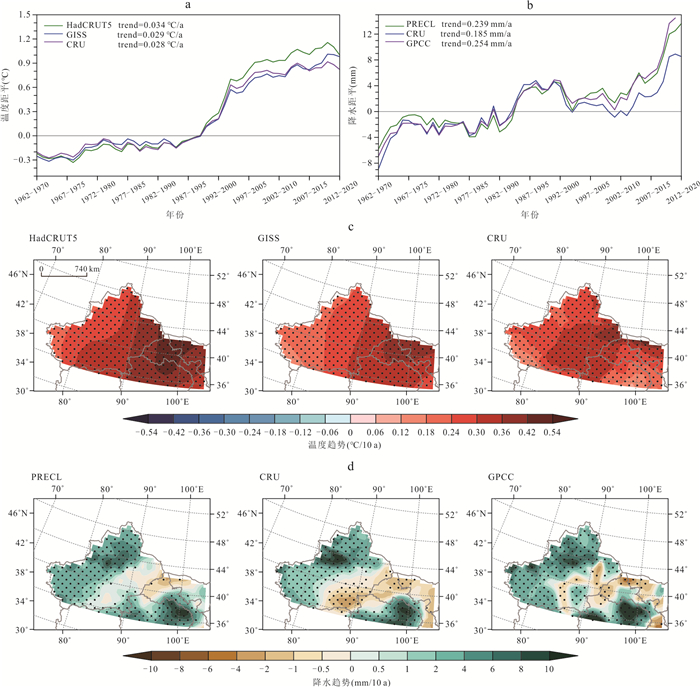
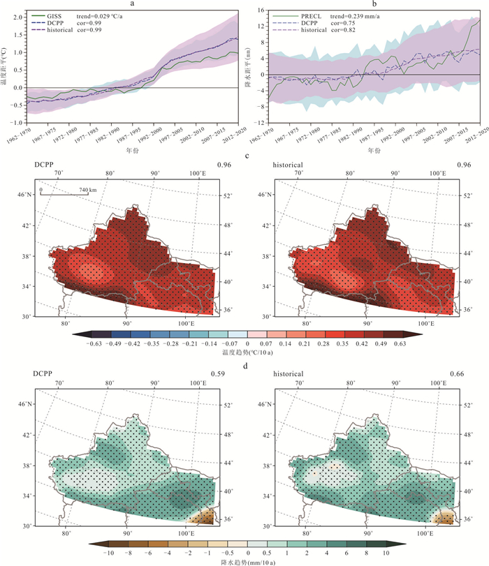
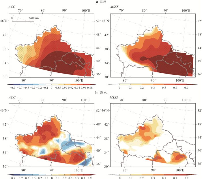
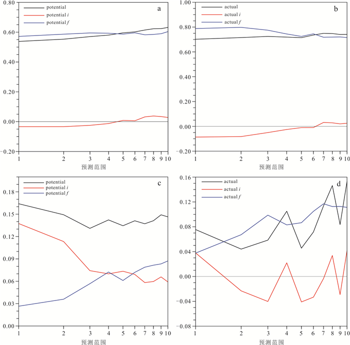
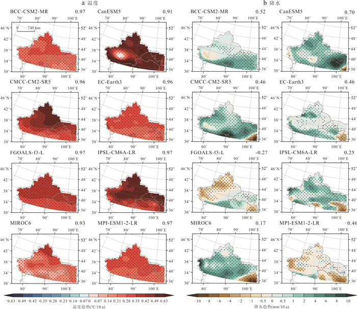
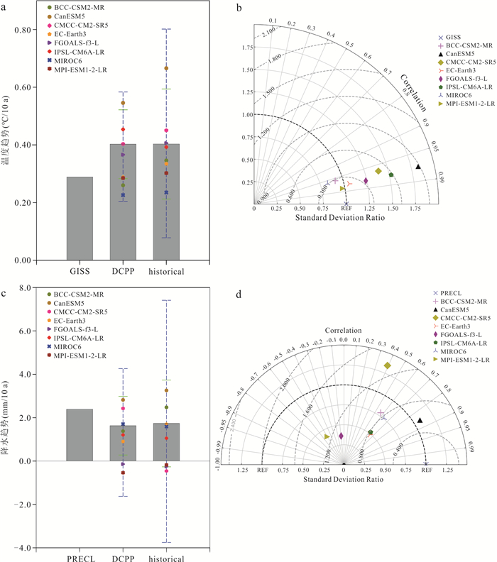
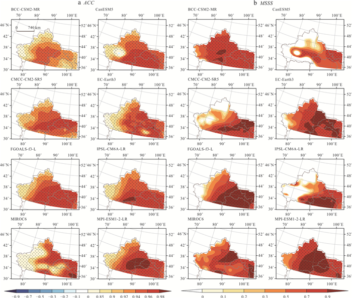
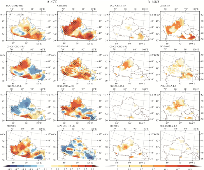
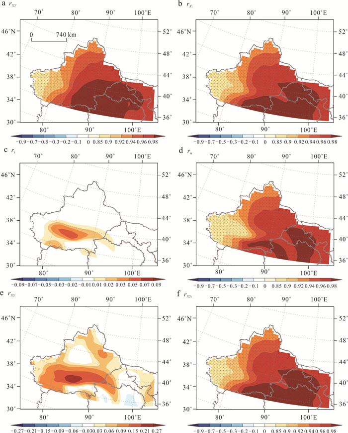
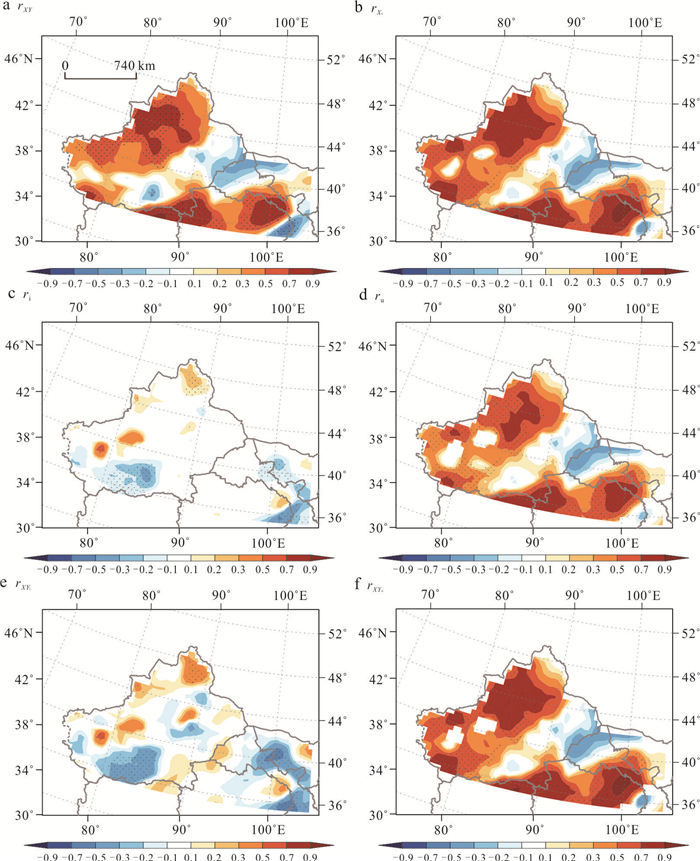
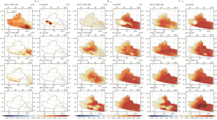
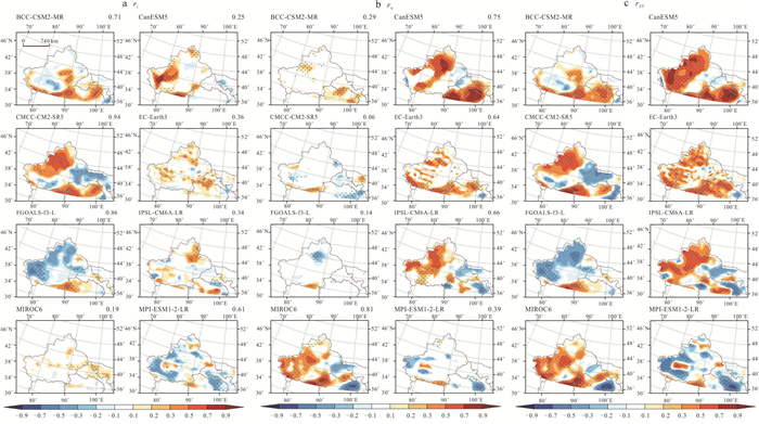
Based on observational data from 1962 to 2020 and the multi-model decadal hindcast and historical simulation experiments from the Decadal Climate Prediction Project (DCPP) under the Coupled Model Intercomparison Project Phase 6 (CMIP6), this paper primarily evaluates the interdecadal predictive skill of the significant summer warming and wetting trends in northwestern China over the past 60 years and its main sources. The interdecadal predictive skill of the multi-model ensemble for warming in Northwestern China, as indicated by the correlation coefficient with observations, is above 0.9. The high predictive skill is mainly attributed to the external forcing component, contributing between 80% and 99%. However, due to the combined influence of external forcing and initialization, there is significant variation in the predictive skill for wetting trends. The contribution of initialize to the predictive skill varies widely among models, ranging from 19% to 94%. This suggests that to achieve accurate short-term projections of future temperature and precipitation changes in Northwestern China, it is crucial to consider not only the impact of external forcing but also the influence of initialize on precipitation.
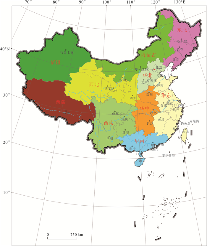
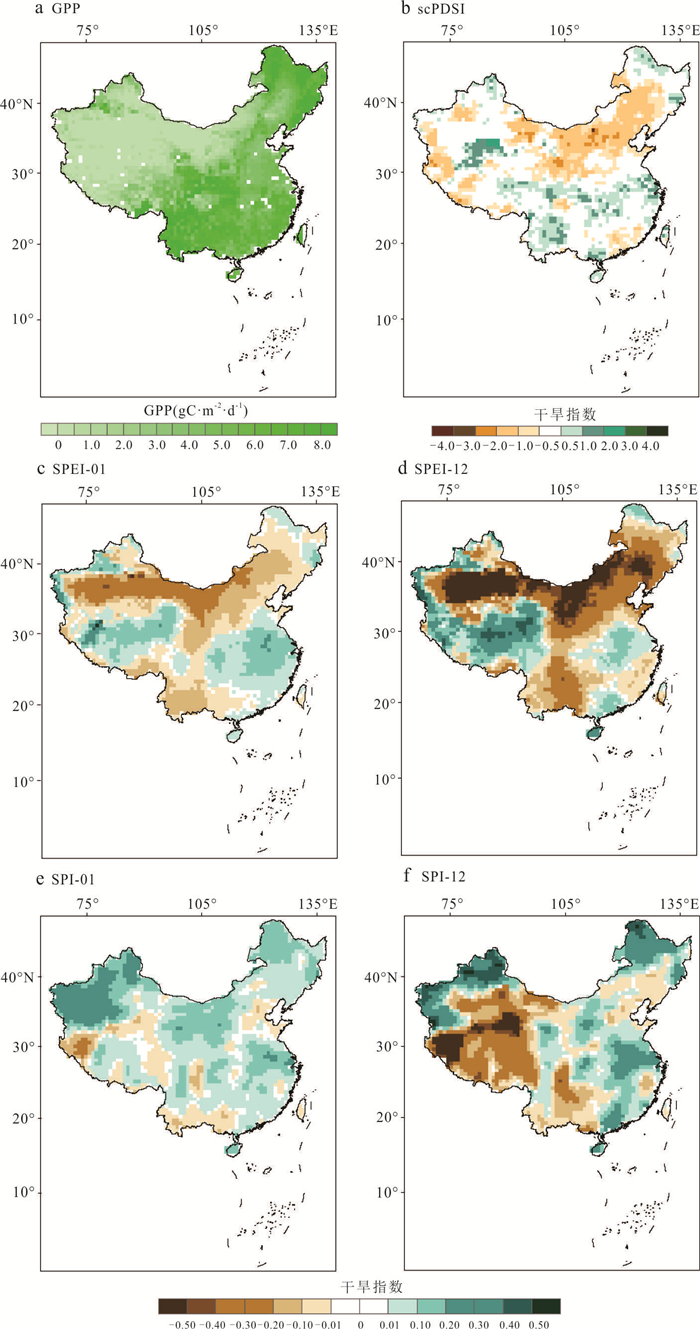
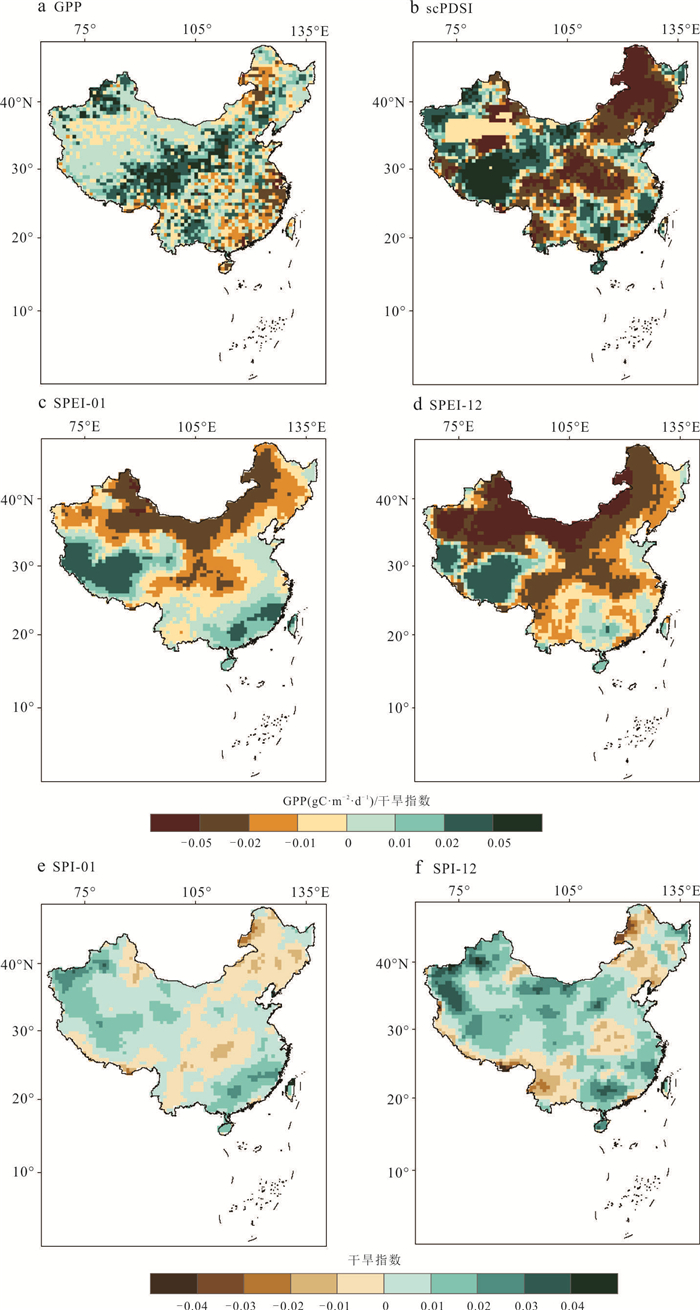
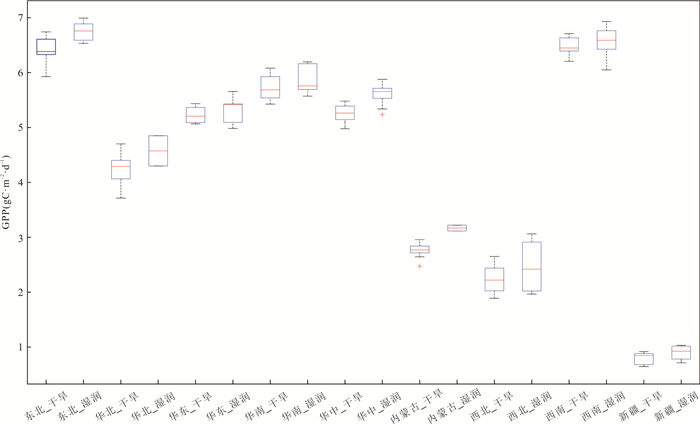
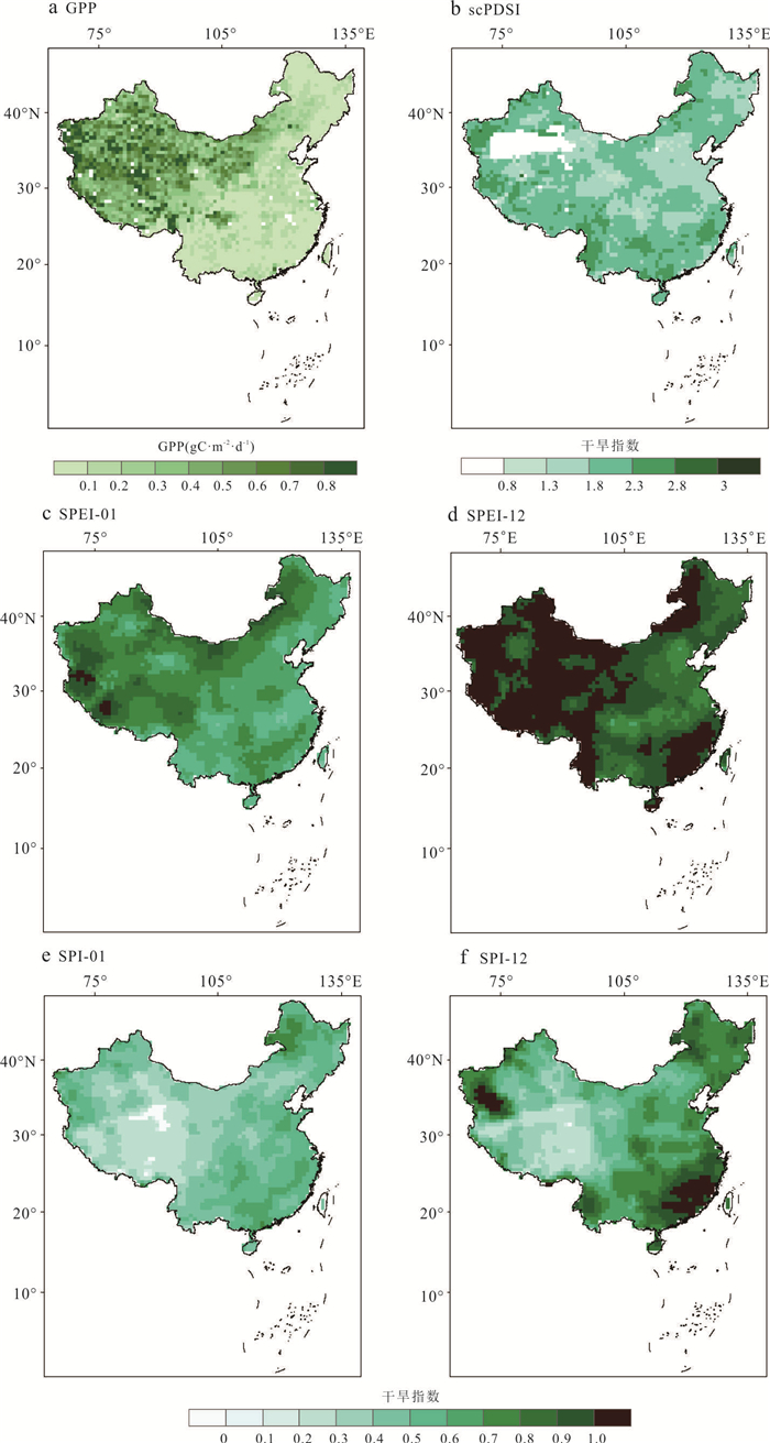
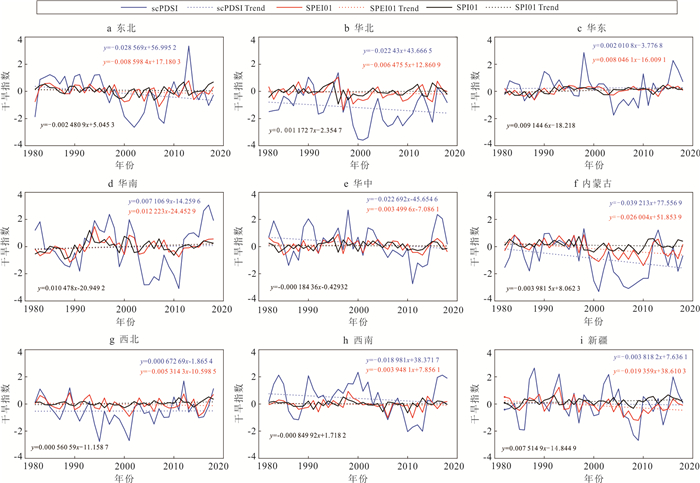
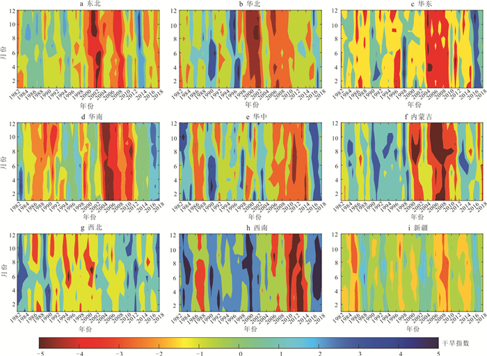
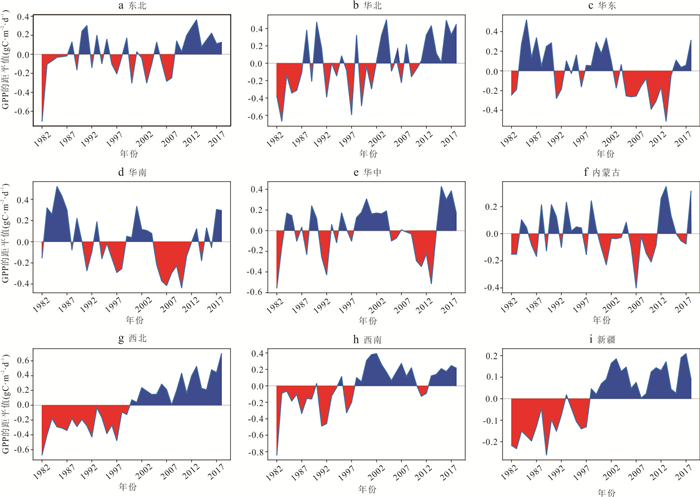
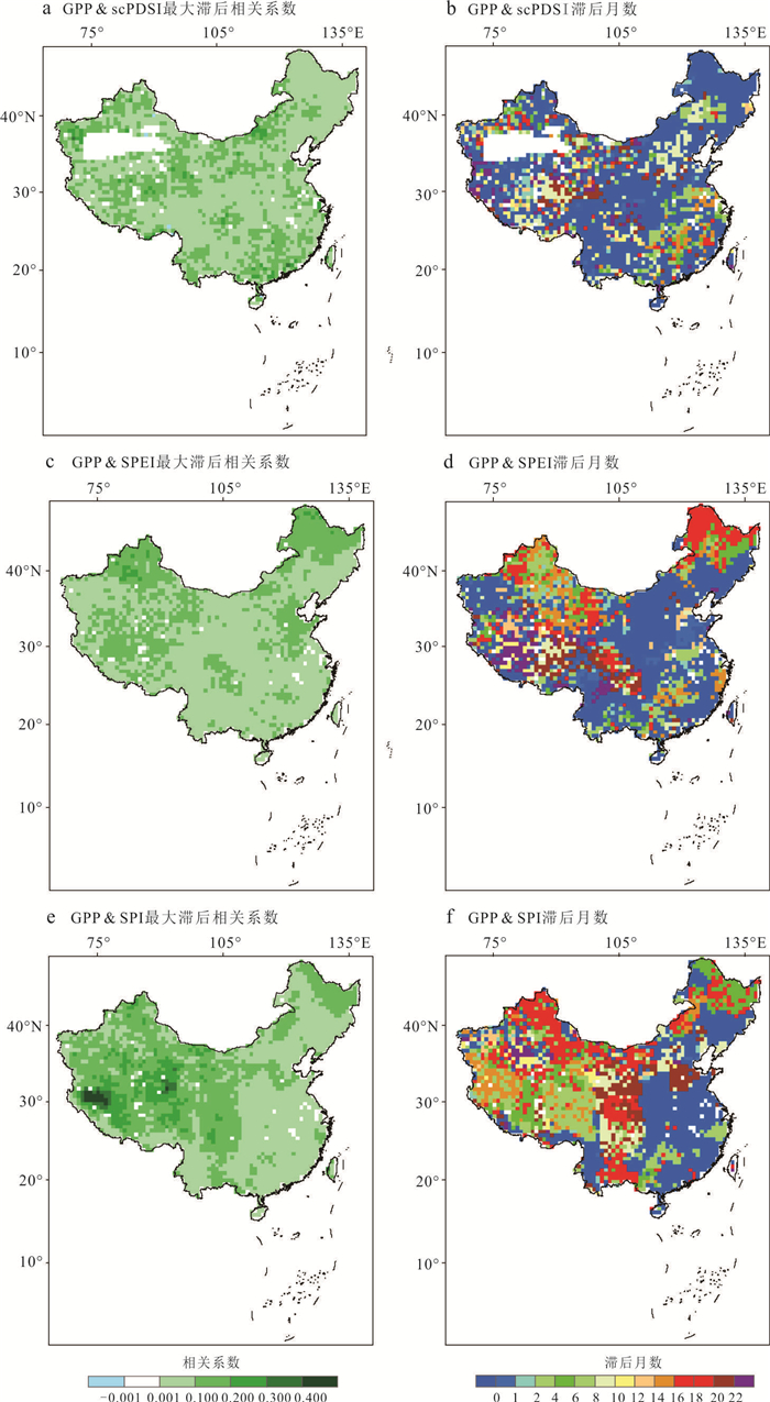
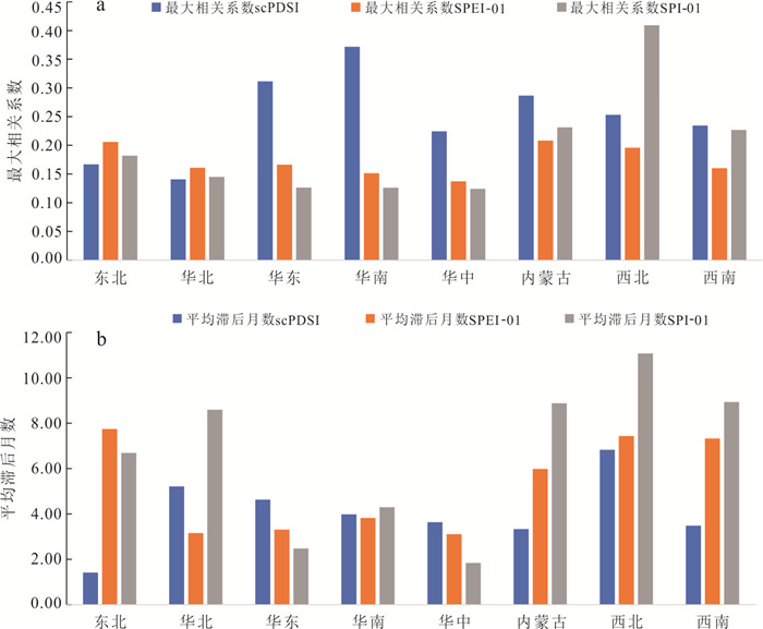
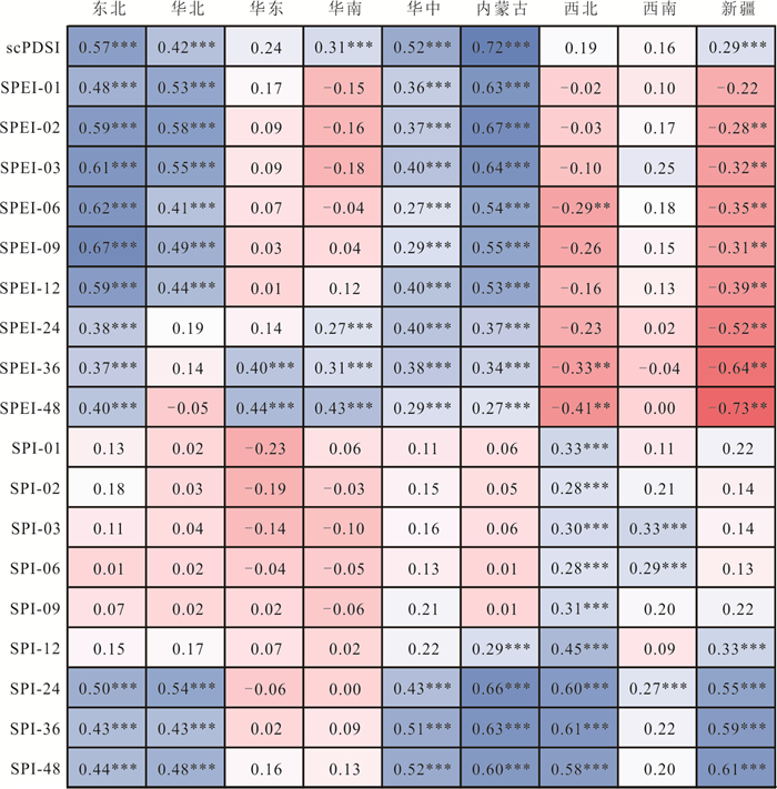
To describe the evolution characteristics of different types of drought and accurately estimate their impact on ecosystems, based on methods such as Mann-Kendall and Pearson correlation coefficients, using the gross primary productivity (GPP) dataset from 1982 to 2018 and concurrent drought indices at different time scales (including scPDSI, SPEI, and SPI), a quantitative assessment was conducted on the response mechanism of the GPP of vegetation in China to different spatiotemporal scales of drought types. The results show that the most significant trend of drought intensification in China is in Inner Mongolia, with the regional averaged scPDSI, SPEI, and SPI declining at an annual rate of 0.039, 0.026, and 0.004, respectively. Further analysis indicates that there are significant differences in the correlation and lag effects between GPP and monthly drought indices in various regions of China. The response to the agricultural drought index is most pronounced in the East China and South China regions, with an average lag time of 4 to 6 months. In contrast, the Inner Mongolia, Northwest, and Southwest regions have a more intense response to meteorological drought, with an average lag time of 9 to 11 months, while the Central and East China regions have a shorter response cycle to meteorological drought, only 0 to 3 months.
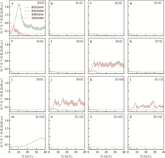
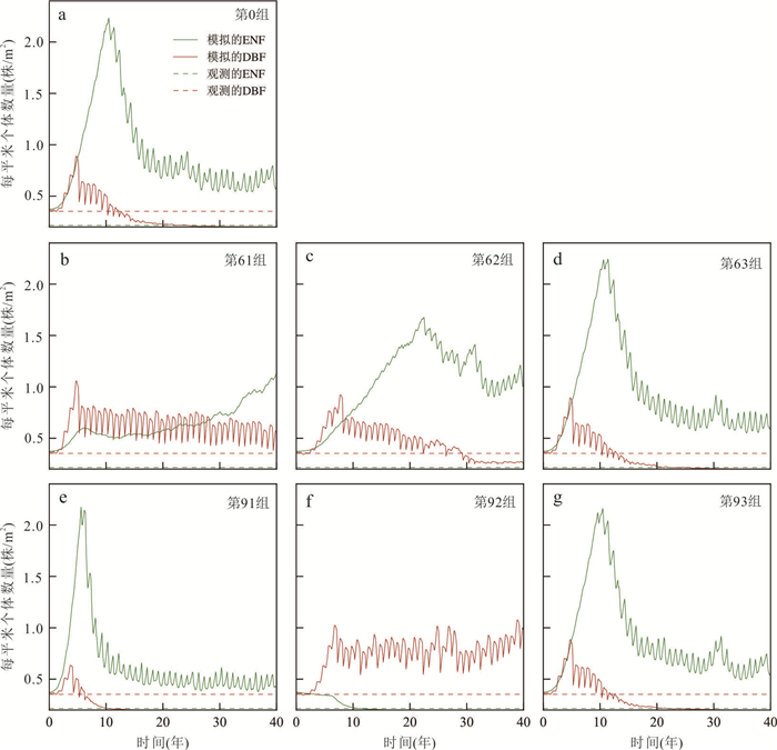
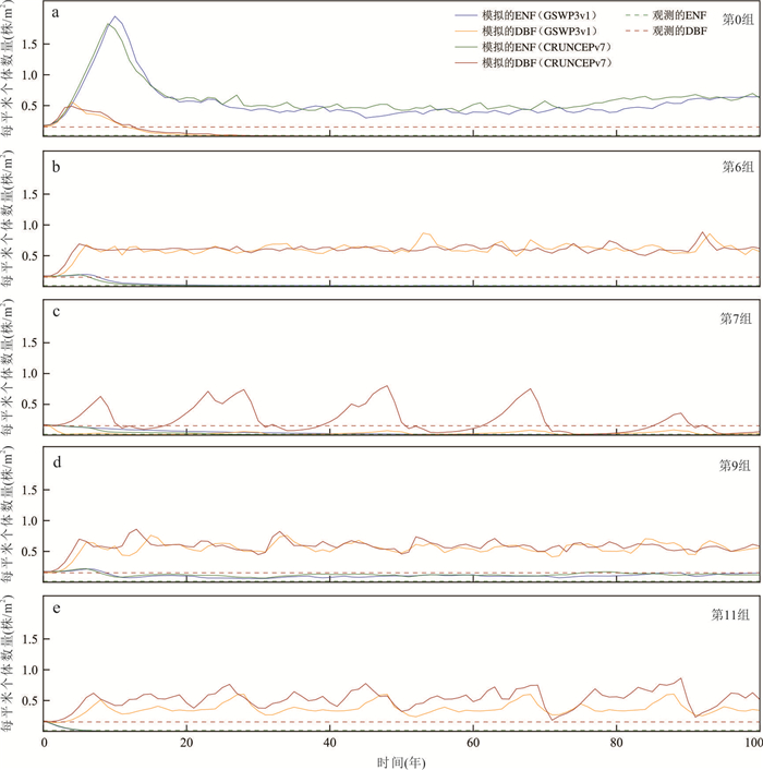
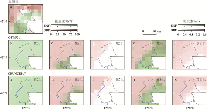
The broadleaved Korean pine forest in Changbai Mountain is one of the few large-area primary mixed needleleaf and broadleaf forest in the world, so it is particularly necessary to conduct simulation research on it. This study is based on the new generation dynamic vegetation model CLM5-FATES (Community Land Model version 5-Functionally Assembled Terrestrial Ecosystem Simulator), by selecting the maximum carboxylation rate at 25 ℃, specific leaf area, and leaf longevity to simulate the distribution of mixed needleleaf and broadleaf forest in Changbai Mountain. This paper explores the parameter sensitivity of the distribution of mixed needleleaf and broadleaf forest in the model, and investigates the model's ability to simulate the distribution of these forests. The study finds that different combinations of trait parameters significantly affect the distribution of vegetation types in the region. The maximum carboxylation rate at 25 ℃ and specific leaf area have a greater impact compared to leaf longevity. Under an appropriate combination of trait parameters, the model can reproduce the observed distribution of mixed needleleaf and broadleaf forest in Changbai Mountain. This study validates the applicability of the model to the mixed needleleaf and broadleaf forest in Changbai Mountain, providing crucial support for further research on climate-vegetation interactions.
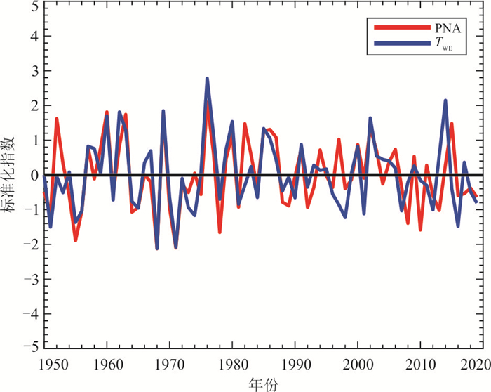
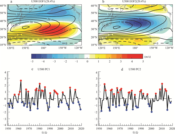
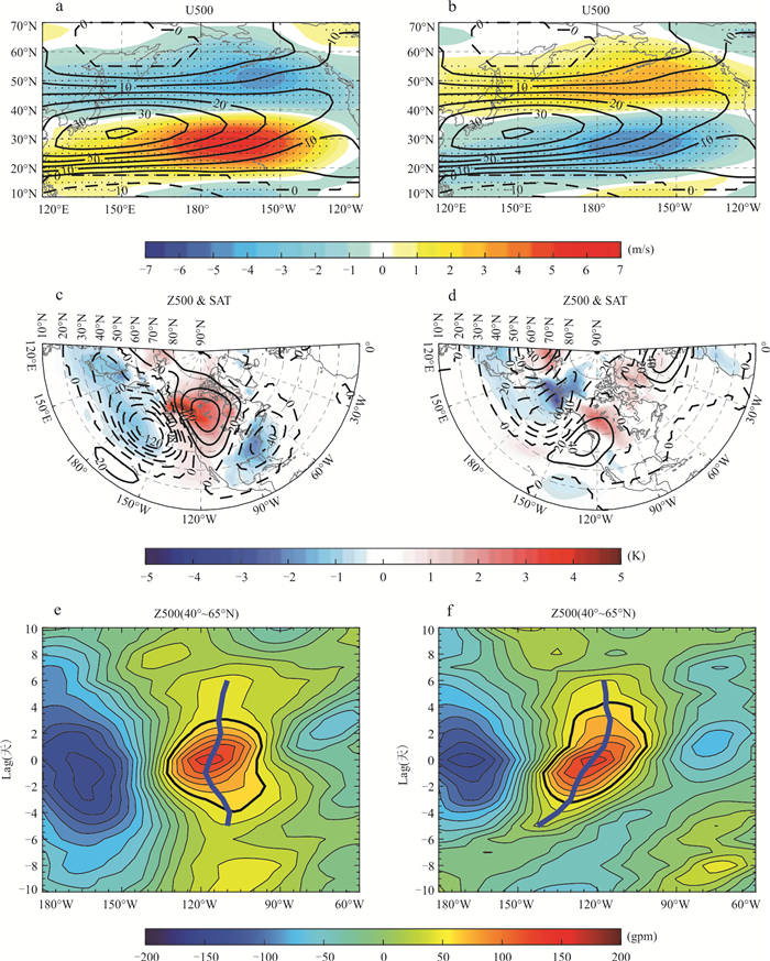
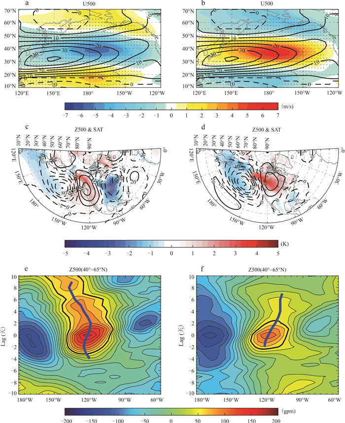
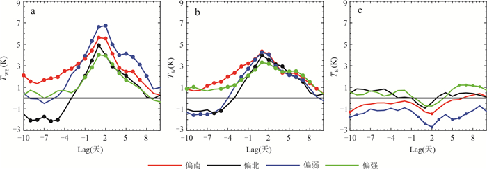
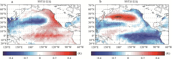
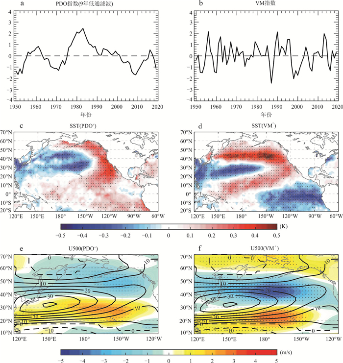
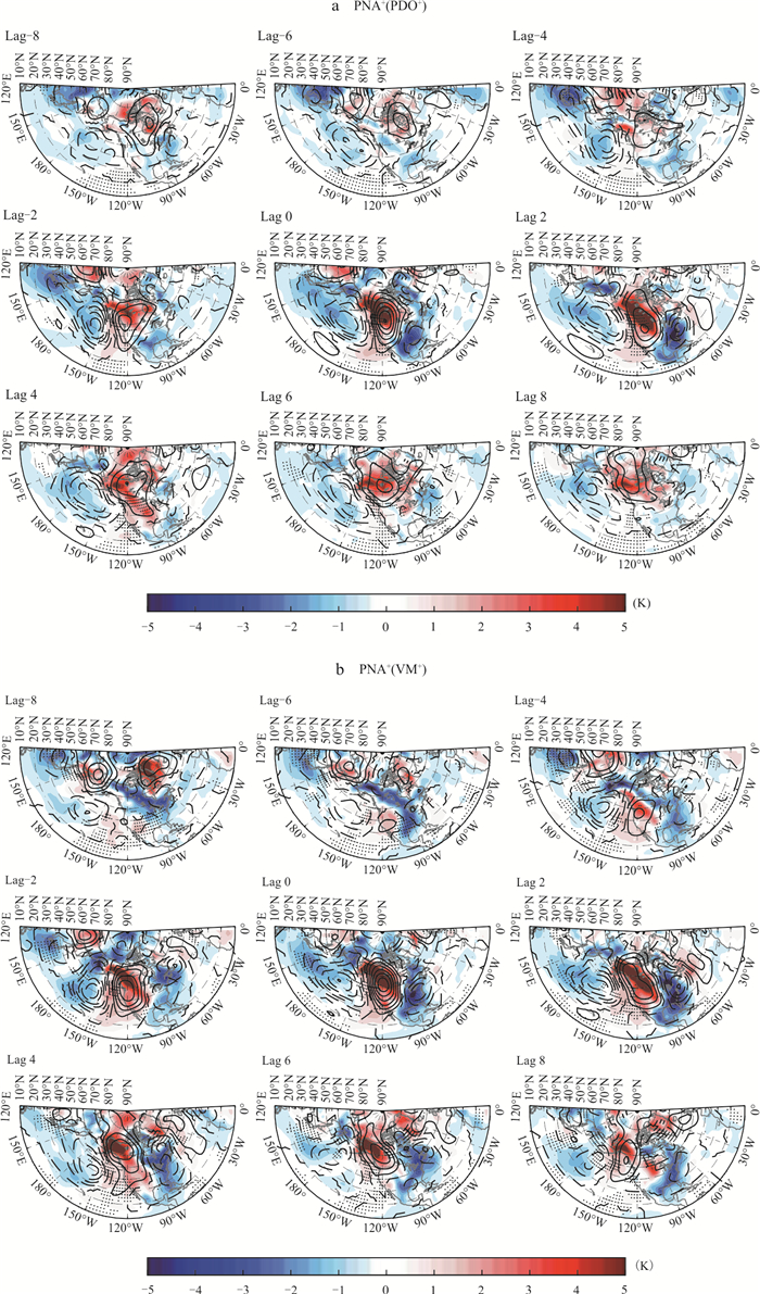
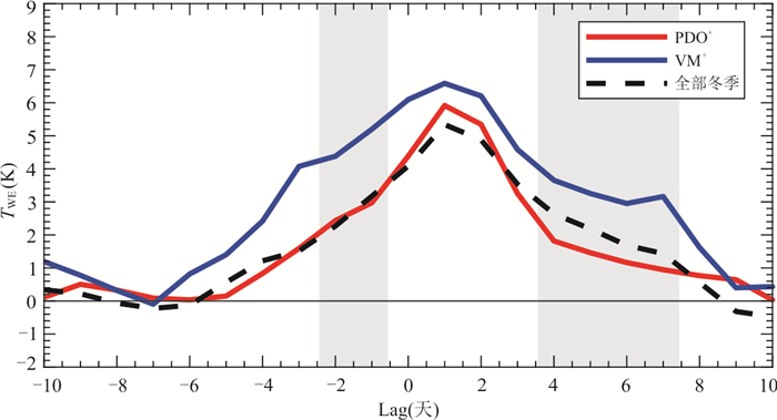
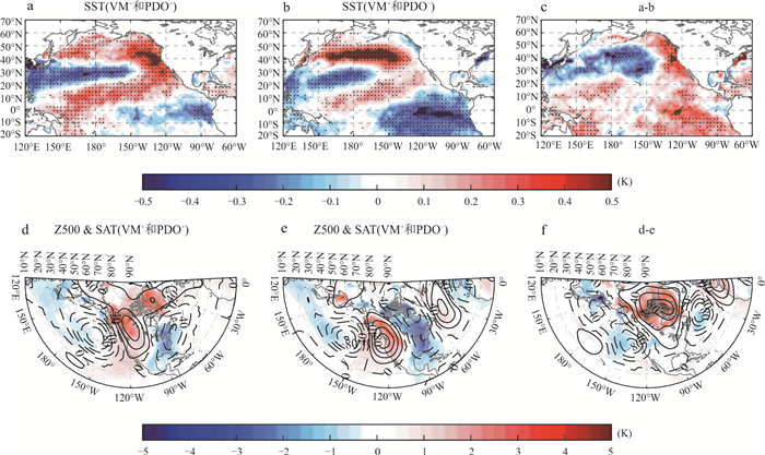
To understand the causes of extreme temperature dipoles in North America during winter, we analyse atmospheric circulation, the westerly jet stream, and the sea surface temperature (SST) background based on reanalysis data. Our study reveals the role of the positive Pacific-North American pattern (PNA+) in driving sub-seasonal temperature dipoles on North America. The results indicate that a weakened North Pacific jet favors the formation of the temperature dipole. Additionally, North Pacific SSTs can modulate the structure and strength of the temperature dipole by influencing the jet stream. Specifically, during the positive phase of the Pacific decadal oscillation (PDO) in winter, a meridionally oriented wave train structure related to PNA+ events is more easily formed, with the North Pacific westerly jet stream shifting southward. This structure contributes to a "warm northwest-cold southeast" temperature anomaly pattern on North America. Conversely, during the positive phase of the Victoria SST pattern, the mid-latitude jet stream is weakened. As a result, the high-pressure system associated with PNA+ shifts westward, while the eastern low-pressure system persists. This forms a horizontal wave train structure, which strengthens the intensity of the "west warm-east cold" surface air temperature dipole anomaly on North America associated with PNA+.
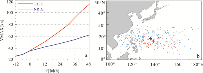
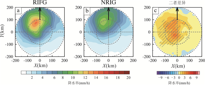
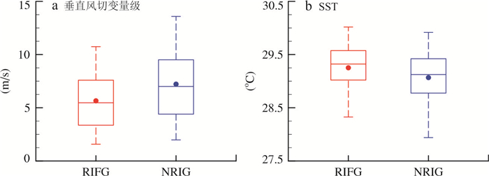
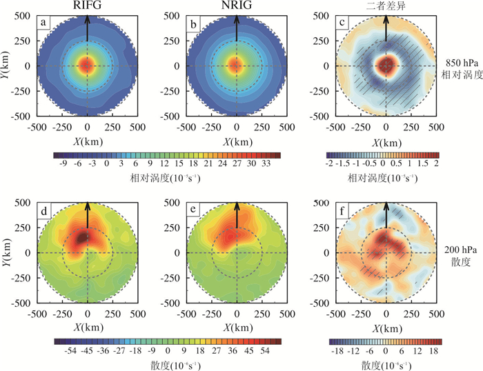
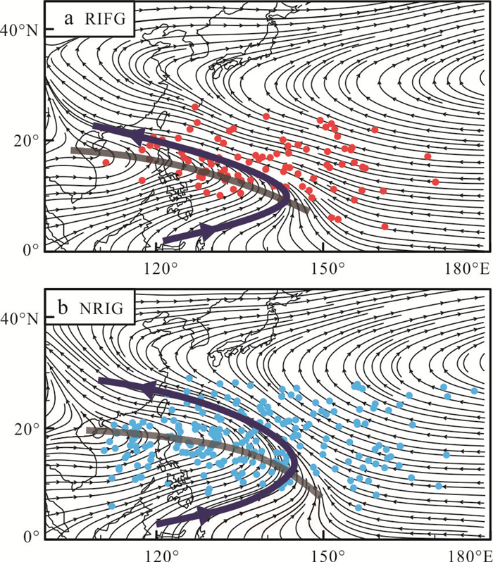
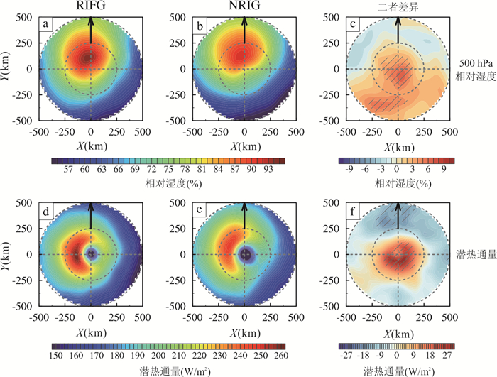
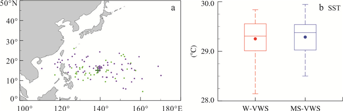
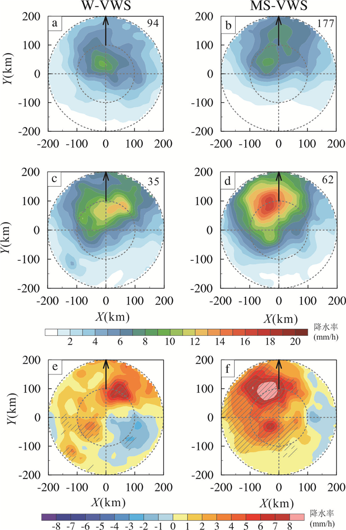
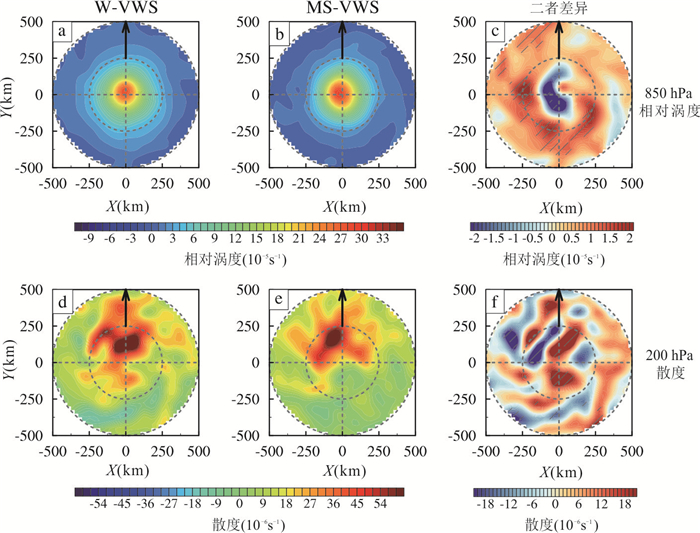
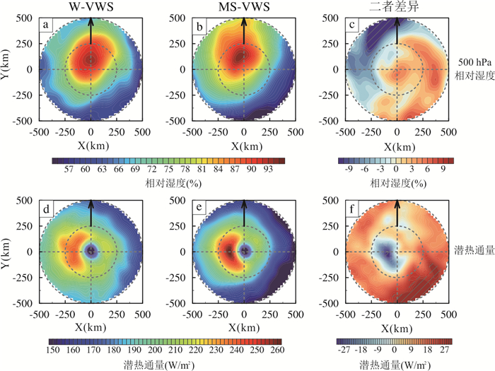
As one of the main challenges in operational forecasting, clarifying the mechanisms behind tropical cyclone (TC) genesis, rapid intensification (RI), and their compound events (RIFG) is of great significance for disaster prevention and mitigation. Based on observational data, this study examines the convective and environmental characteristics of RIFG events and non-RI genesis events (NRIG) over the western North Pacific. On average, RIFG cases occur at lower latitudes compared to NRIG cases, and have stronger inner-core precipitation on the upshear left side. These cases are also associated with weaker vertical wind shear and background relative vorticity, higher inner-core relative vorticity, upper-level divergence, sea surface temperature, mid-level relative humidity, and surface latent heat flux. These favorable dynamic and thermodynamic conditions provide the basis for RIFG events. Further comparison between RIFG cases under weak vertical wind shear (W-VWS) and moderate-strong vertical wind shear (MS-VWS) shows that MS-VWS cases exhibit stronger and more asymmetric precipitation. Additionally, W-VWS (MS-VWS) cases experience more favorable environmental dynamic and thermodynamic conditions on the upshear and right-of-shear sides (downshear and left-of-shear sides), respectively.
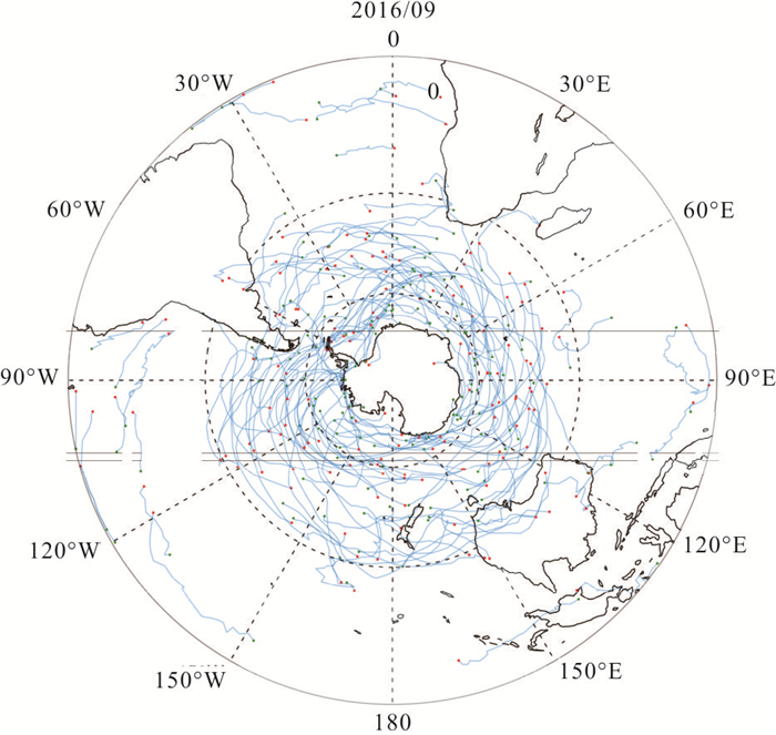
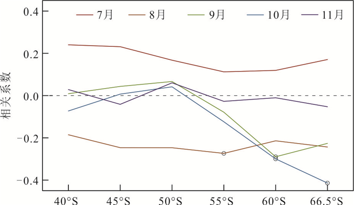
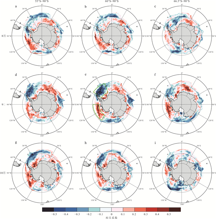
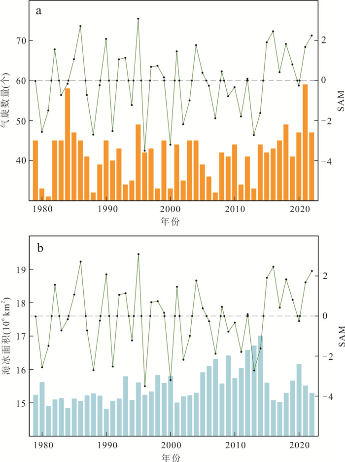
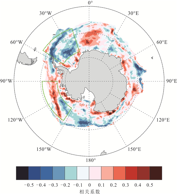
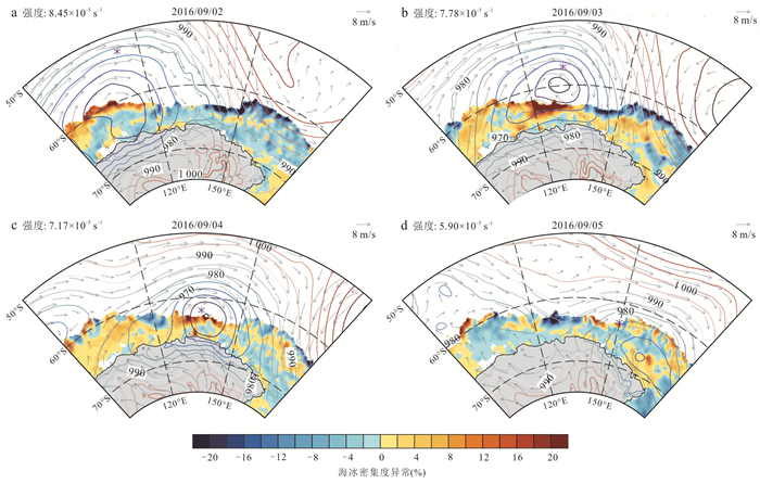
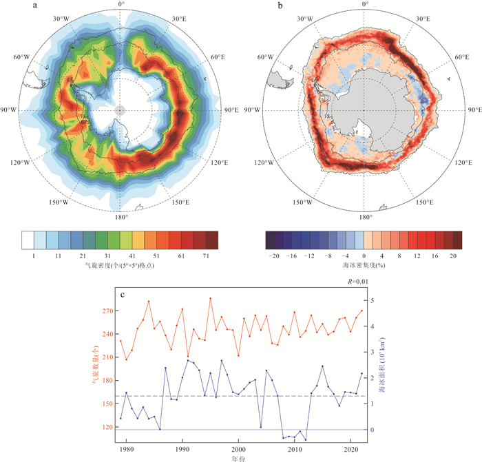
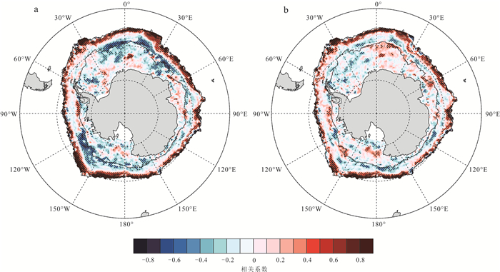
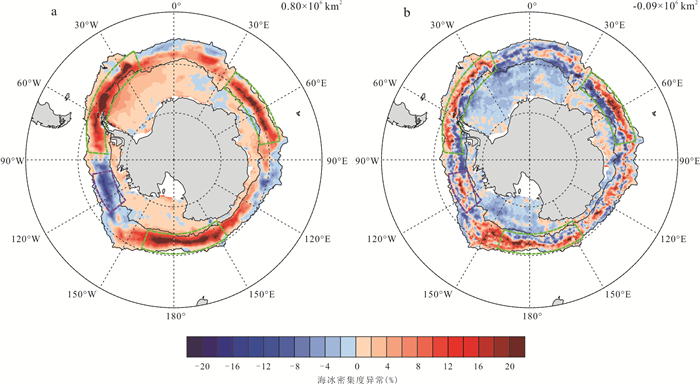
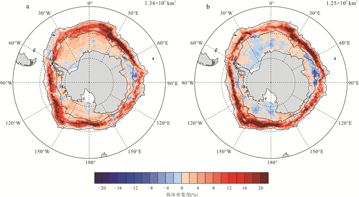
The long-term effects of mid-high latitude cyclones on Antarctic sea ice extent (SIE) were investigated using reanalysis data from European Center for Medium-Range Weather Forecasts (ECMWF) for September, spanning from 1979 to 2022. This study examines the correlation between the frequency of mid-high latitude cyclones and SIE, as well as analyzes the spatiotemporal distribution of SIE anomalies caused by cyclones. The results indicate that the mid-high latitude cyclones predominantly influence Antarctic sea ice within the marginal ice zone, where the sea ice concentration (SIC) is less than 80% and exhibits frequent changes across most regions. These findings reveal that SIE is more susceptible to Southern Annular Mode (SAM) than to cyclones in most regions of Antarctica. However, cyclone-induced variations in SIC are significant within the Antarctic marginal ice zone, particularly near the sea ice edges, where cyclones are the primary drivers of SIC fluctuations. The influence of cyclones on SIC variations depends on the initial SIC amount, with variations decreasing as SIC reaches a certain high value.

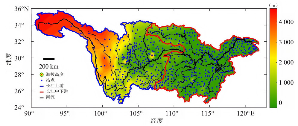
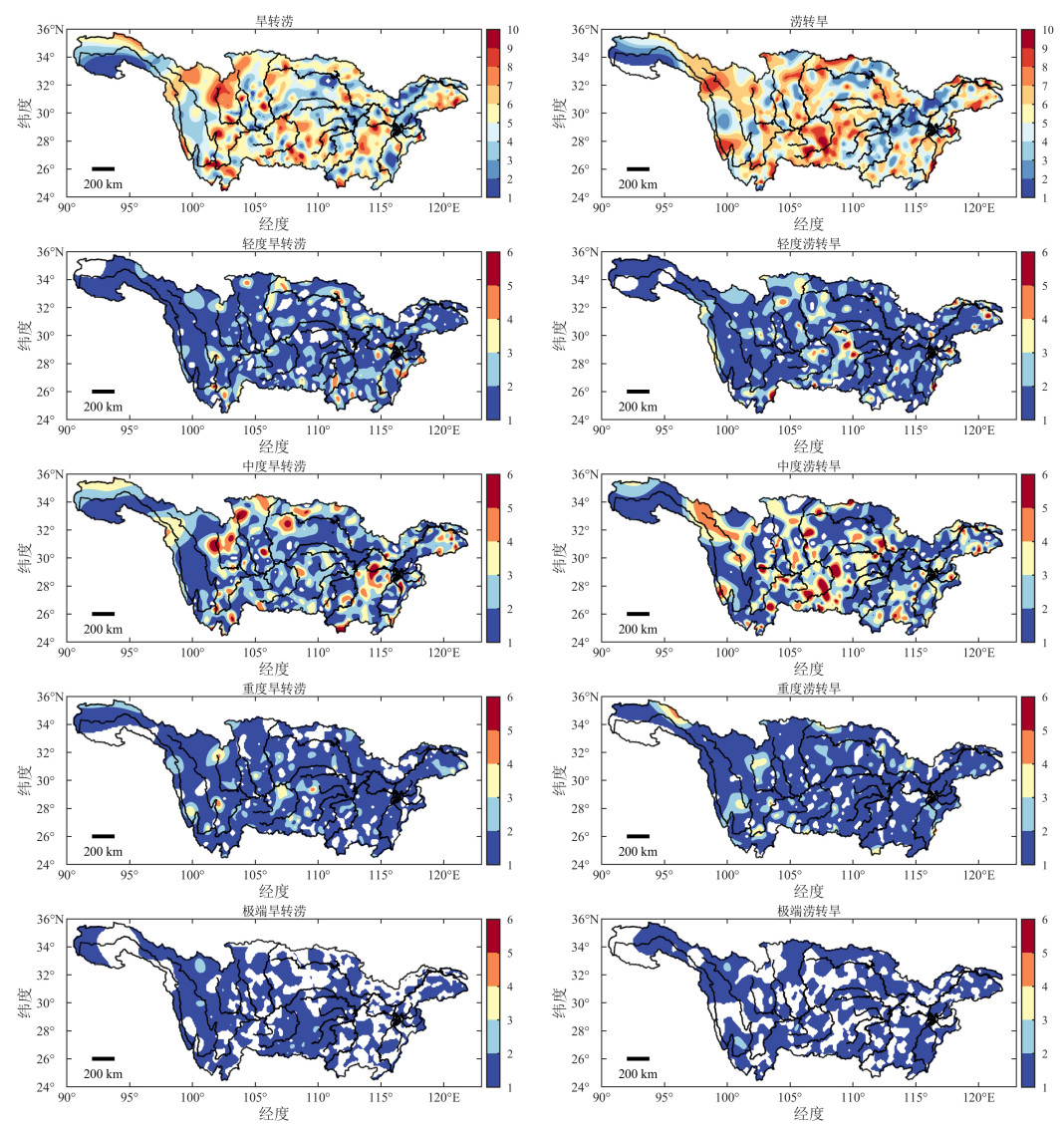
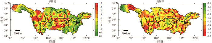
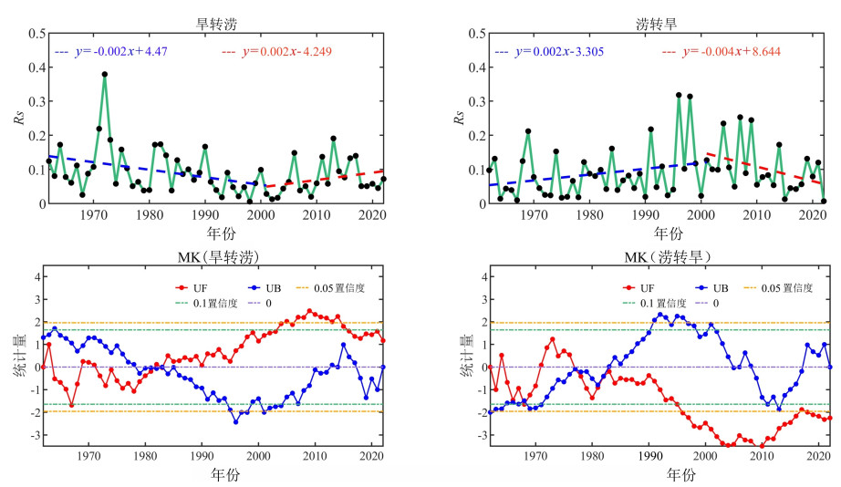
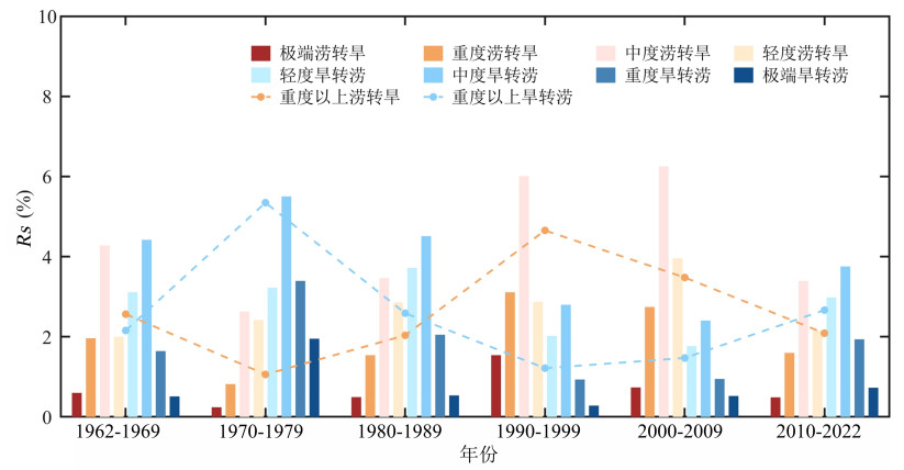
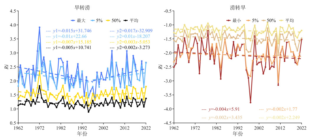
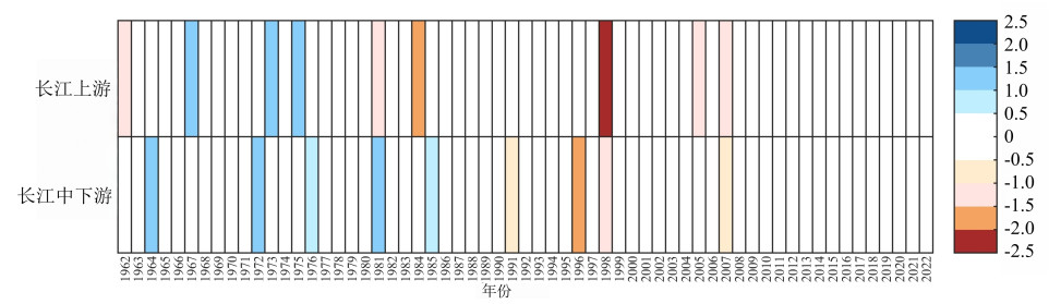
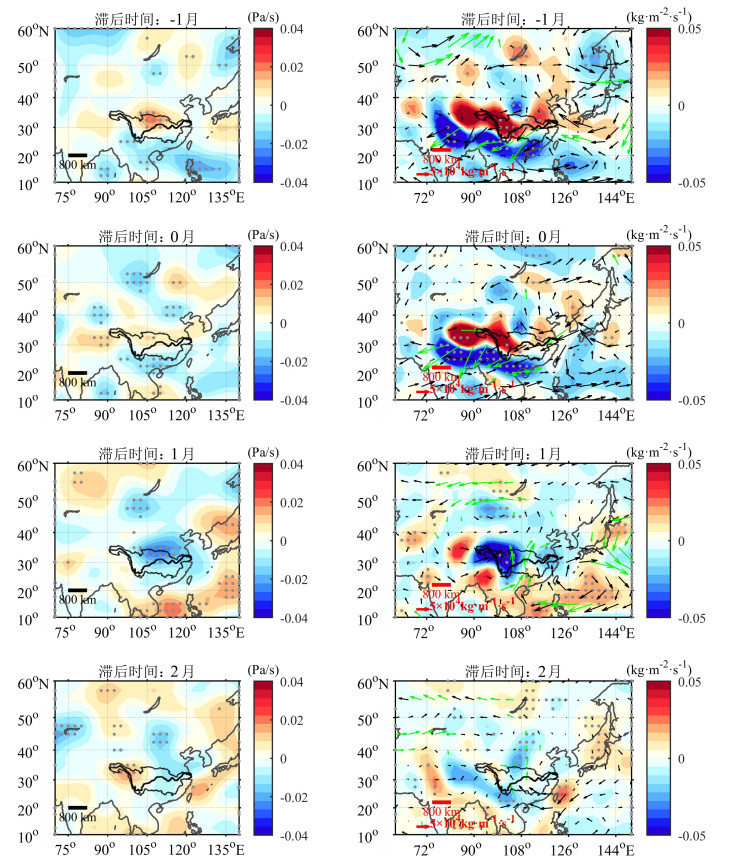
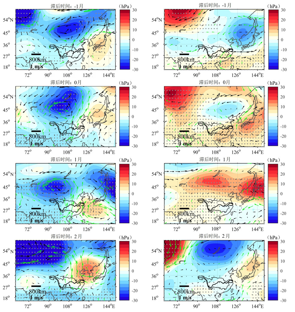
Autumn drought and flood alternation (DFA) has very serious impacts on water storage in reservoirs, power generation, and water supply in the Yangtze River basin (YRB). This paper analyzed the spatial and temporal characteristics of autumn DFA in the YRB by using the multi-scale standardized DFAI index (MSDFAI), which comprehensively considers the effects of alternation intensity and speed, and the associated weather situation alternation was analyzed from the perspective of the atmospheric driving. The results show that the high incidence areas of autumn drought to flood alternation events (DTF) from 1962 to 2022 in the YRB are mostly located in the middle and lower Jinsha River, upper Yalong River, Jialing, Min and Wu Rivers, Hanjiang River above the Shiquan station, and the Poyang Lake water network, in which the frequency of moderate events is the highest. The range of DTF in the YRB shows a decreasing trend before the mid-90s, and then turn to an increasing trend. Similarly, the intensity of extreme DTF in local areas weaken before mid-90s, and then increase, while the flood to drought alternation events (FTD) are on the contrary. The mode decomposition shows that the second pattern is mainly characterized by consistent DTF anomalies in the north of the main stream of the upper reaches of the Yangtze River and the upper reaches of the Han River (key area). Before the alternation, most of southern China is controlled by negative geopotential height anomalies, and the wind field and water vapor transport in the key area are divergent anomalies, and the vertical direction is controlled by the dry subsiding flow, which is unfavorable to the occurrence of rainfall. One month after the alternation, there is a positive anomaly in the geopotential height in the middle and lower YRB, the west Pacific subtropical high is intensified and extends westward and the northern low-pressure trough extends southward. Meanwhile, the wind field and water vapor transport in the key area shows a converging anomaly, and the vertical direction is controlled by updrafts and conduced to heavy rainfall. The above weather situation transition leads to a DTF event, while the FTD event is the opposite.

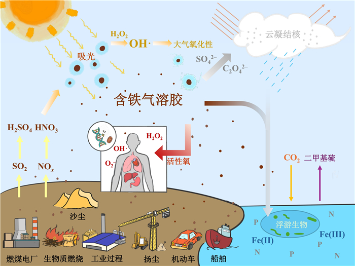
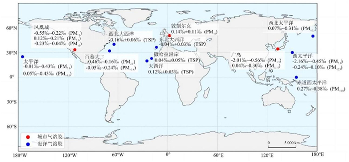
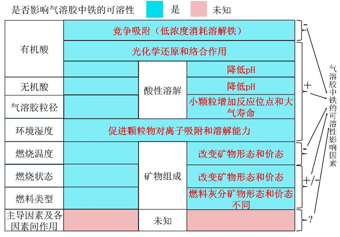
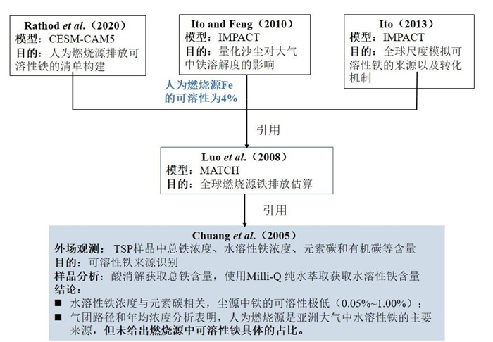
Soluble iron in atmospheric aerosols substantially influences marine primary productivity, climate change, secondary atmospheric pollution, and human health. Identifying sources and developing high-accuracy emission inventories of soluble iron are fundamental for refining biogeochemical models to simulate iron deposition fluxes and marine productivity, improving atmospheric chemistry transport models for secondary aerosol simulations and quantifying the sources and contributions of soluble iron affecting human health. This study systematically reviews the source apportionment of iron and soluble iron in atmospheric aerosols, the key factors and underlying mechanisms governing iron solubility, and recent methodological advances in sampling and characterization of combustion-derived iron-containing aerosols. With particular focus on emission inventory development for combustion-related soluble iron, we critically examine current methodologies and identify persistent challenges. It is expected the summarization here provides a basic dataset and theoretical frameworks for accurate assessment of iron's climatic, environmental and health impacts.
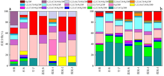
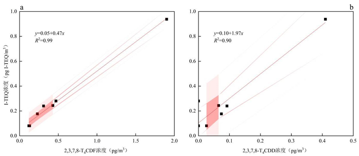
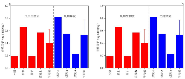
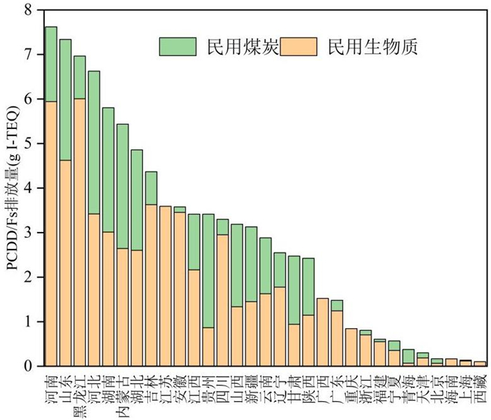
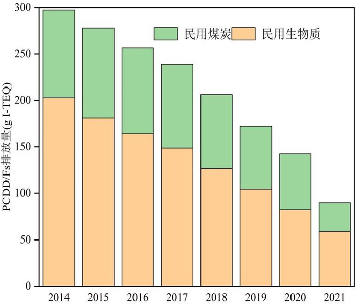
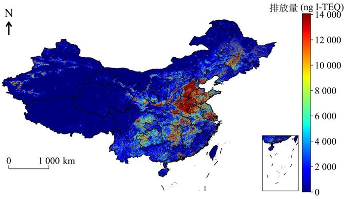
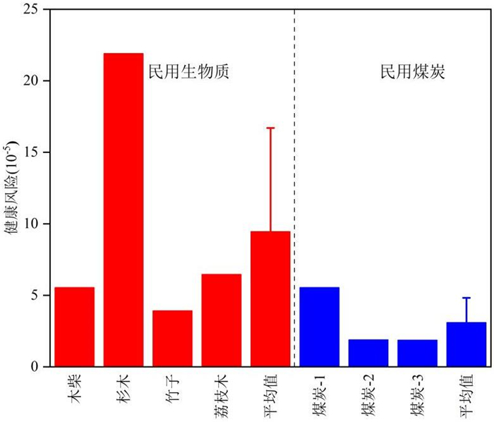
Indoor simulation combustion experiments were performed using a dilution tunnel sampling system. The emission characteristics of PCDD/Fs in PM2.5 from domestic biomass and coal combustion were analyzed using isotope dilution high-resolution gas chromatography/mass spectrometry (HRGC/HRMS), with subsequent calculation of emission factors. By integrating China's fuel consumption and population density data, we developed a "bottom-up" emission inventory for PM2.5-bound PCDD/Fs from domestic biomass and coal combustion in China. The key findings are as follows: (1) The mass concentrations of PCDD/Fs in PM2.5 from domestic biomass and coal combustion ranged from 0.181 to 4.700 pg/m3, with international toxic equivalent (I-TEQ) concentrations of 0.081 to 2.300 pg I-TEQ/m3. Congener analysis revealed that 2, 3, 7, 8-T4CDD (P < 0.01, R2=0.90) showed strong correlations with I-TEQ concentration, suggesting its potential as reliable toxicity indicators for PM2.5-bound PCDD/Fs from domestic biomass and coal combustion. (2) The mass-based emission factors of PCDD/Fs in PM2.5 were (1.82±0.97) ng/kg for biomass combustion and (4.09±2.76) ng/kg for coal combustion. The corresponding I-TEQ emission factors were (0.40±0.21) ng I-TEQ/kg (domestic biomass) and (0.53±0.24) ng I-TEQ/kg (domestic coal). (3) In 2021, the total emissions of PCDD/Fs in PM2.5 from domestic biomass and coal combustion reached 90.0 g I-TEQ. With spatial analysis showing emission hotspots (> 8 μg I-TEQ/km2) concentrated in Northeast and East China. Compared to previous studies, the emissions of PCDD/Fs in PM2.5 from waste incineration (22.56 g I-TEQ) and industrial combustion (208 g I-TEQ) were 0.2 times and 1.5 times those from domestic biomass and coal combustion, respectively. These results highlight that domestic biomass and coal combustion represent non-negligible and substantial sources of PCDD/Fs in PM2.5. (4) The estimated inhalation cancer risks were (9.5±7.2)×10-5 for domestic biomass combustion and (3.1±1.7)×10-5 for domestic coal combustion, representing 3.3-fold and 1.1-fold increases respectively over occupational exposure risks for industrial workers ((2.88±2.45)×10-5).
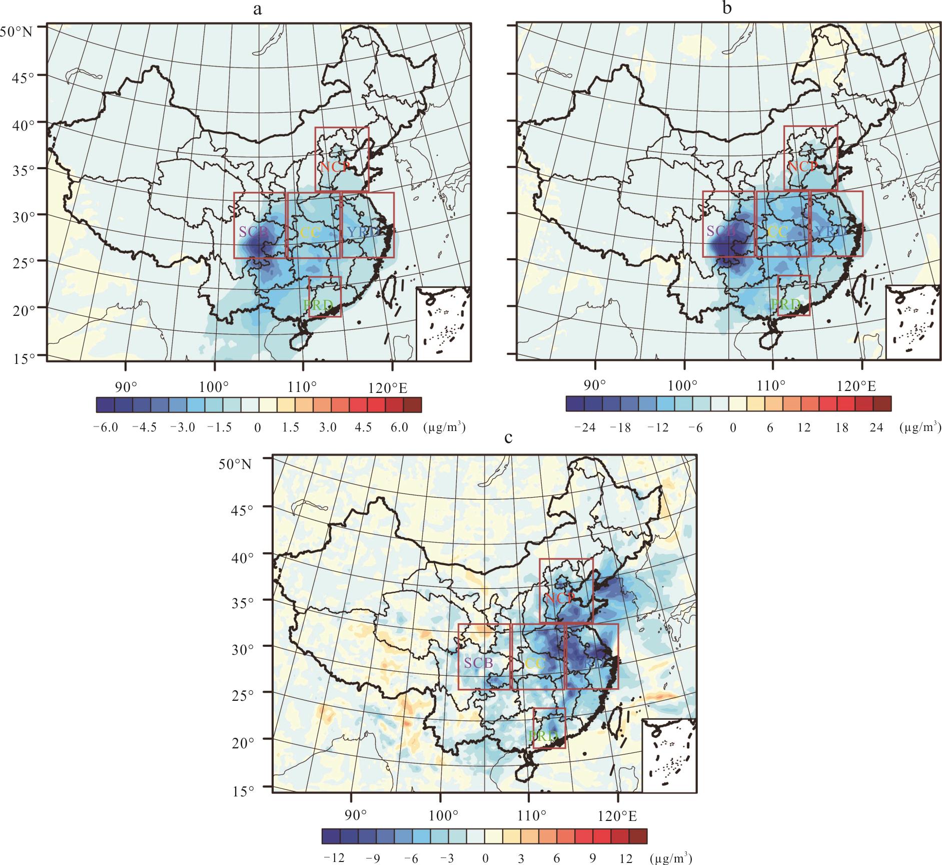
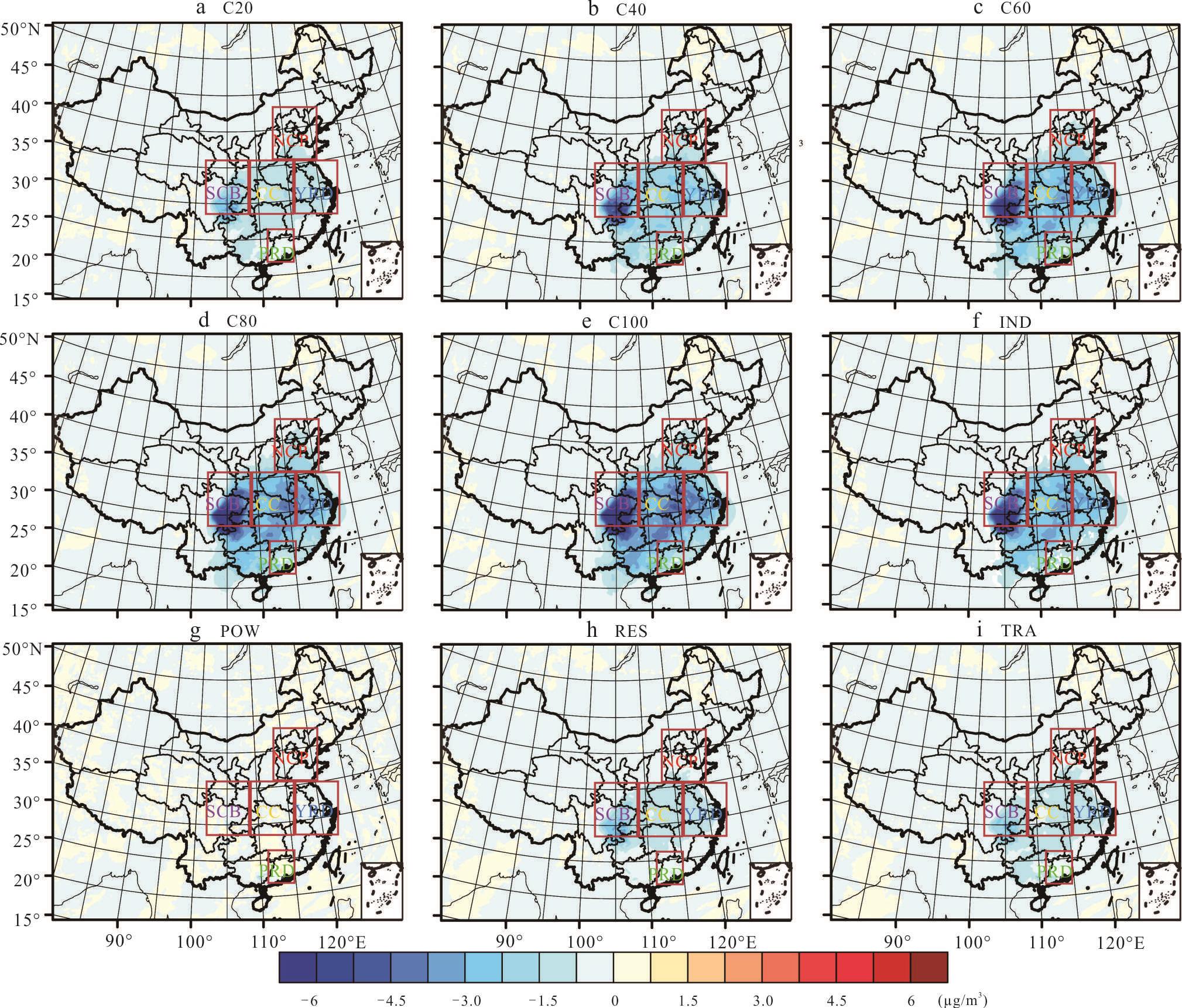
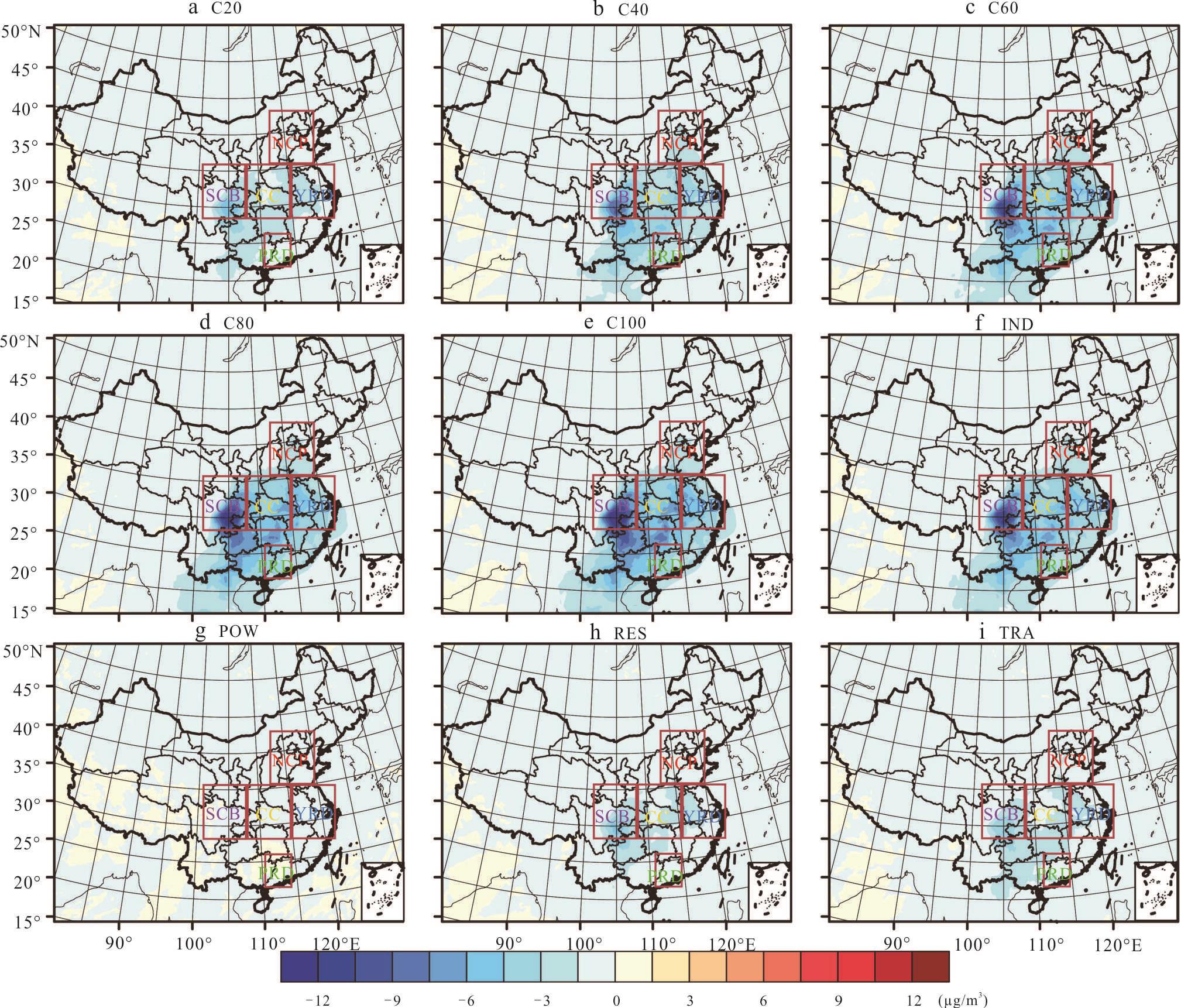
Volatile organic compounds (VOCs) are the important precursors of ozone (O3) and secondary organic aerosols (SOA). However, current research on the mitigation of SOA and O3 by VOCs emission reduction is still insufficient. In this study, based on previous research and policies, a refined VOCs emission reduction potential covering four major emission sources was summarized. The benefits of VOCs emission reduction on SOA and ozone mitigation during the pollution events for five major air pollution regions in China were quantified using the WRF-Chem model. The results showed that the refined VOCs emission reduction strategy could reduce the SOA concentrations by 89.2%, 81.2%, 74.5%, 72.0%, and 77.3% in the North China Plain region, Yangtze River Delta, Central China, Pearl River Delta and Sichuan Basin, respectively. The reduction potential of industrial VOCs emissions is the main contributor to the SOA mitigation in these five regions. Nevertheless, such VOCs emission reduction could only reduce ozone concentration by less than 10%, due to the nonlinear photochemical processes of ozone and its precursors. The refined VOCs emission reduction strategy could reduce the O3 concentrations by 7.55, 9.05, 7.29, 4.31, and 3.15 μg/m3 in five areas, respectively. VOCs emission reduction of industry, transportation and residential could reduce the ozone concentration by 3.6% (3.48 μg/m3), 2.2% (2.07 μg/m3) and 1.1% (0.98 μg/m3), respectively, on average in the five main air pollution regions.
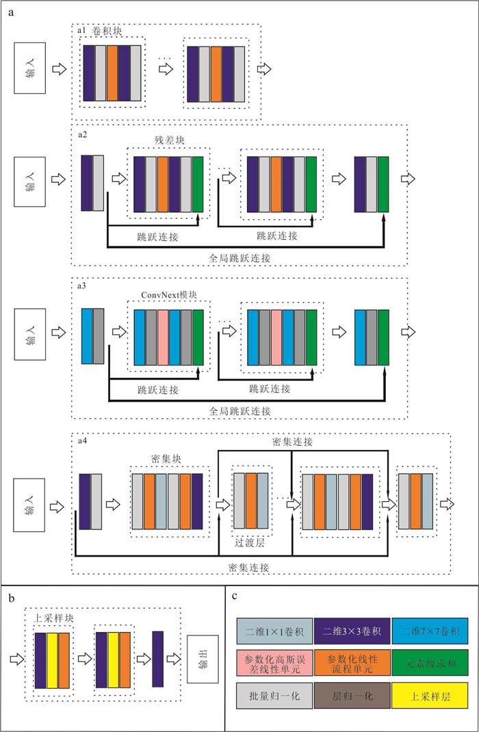
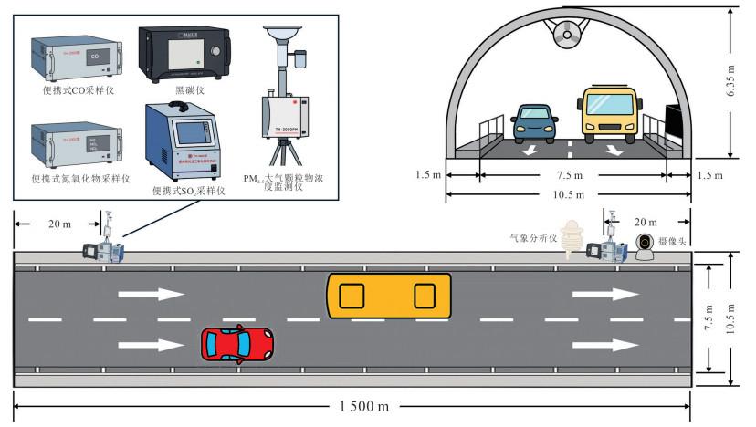
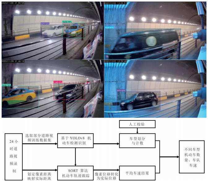
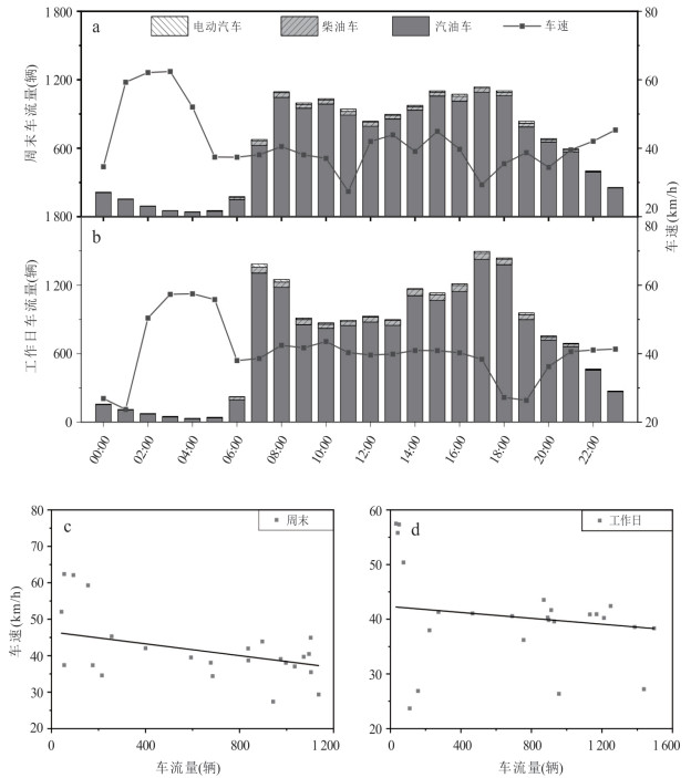
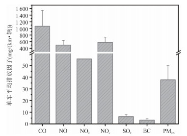
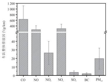
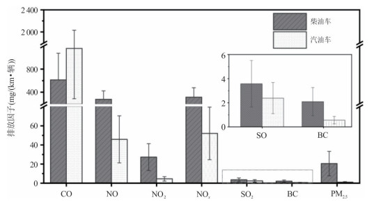
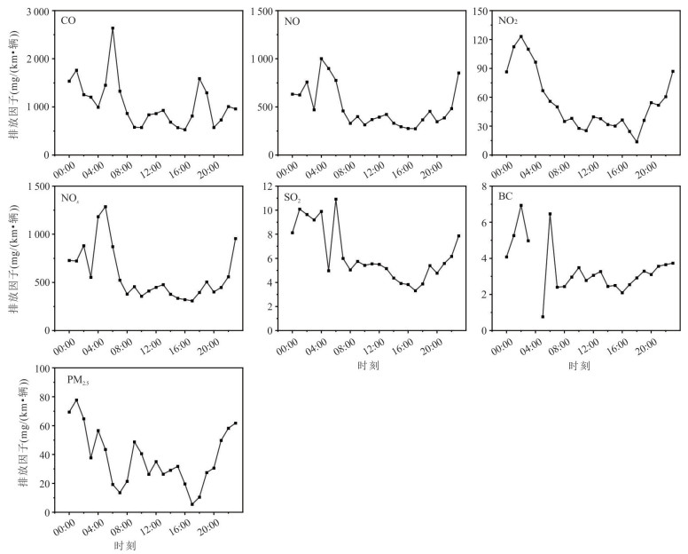
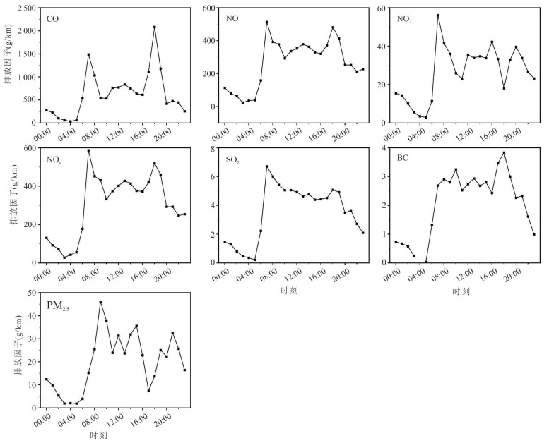
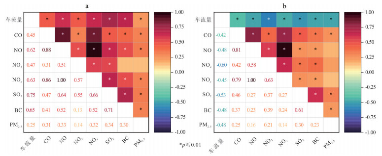
Dynamic emission factors of motor vehicle air pollutants are a key parameter limiting the improvement of real-time emission inventory accuracy. In this study, a tunnel in a metropolitan area was selected as an observation site. Real-time monitoring of the concentrations of seven air pollutants (CO, NO, NO2, NOx, SO2, BC, and PM2.5) and traffic flow was conducted using online monitoring instruments and surveillance cameras. Vehicle type and speed were obtained by applying the YOLOv8l deep learning object detection model in combination with the SORT tracking algorithm. Based on the emission intensity ratio method, the average emission factors for the entire fleet and for different vehicle categories were estimated to be (1 064.9±479.8), (496.5±209.3), (55.5±30.4), (578.6±267.6), (6.3±2.2), (3.3±1.5), and (37.7±19.2) mg/(km·veh) for CO, NO, NO2, NOx, SO2, BC, and PM2.5, respectively. The overall fleet emission factors were (634.7±477.2), (266.0±142.9), (26.4±13.5), (302.3±159.5), (3.5±1.9), (2.0±1.1), and (19.8±12.3) g/km for these pollutants, respectively. During the observation period, the average daily traffic volume on weekends was 88.6% of that on weekdays. Except for PM2.5, weekday emission factors for all pollutants were 1.0-1.48 times higher than those on weekends. Hourly analysis showed that the proportion of diesel vehicles during the early morning was 1.6 times that of other periods, with pollutant emission peaks 2.0-3.5 times the daily average. Fleet emissions exhibited a bimodal diurnal pattern, peaking during morning (07:00-09:00) and evening (17:00-19:00) rush hours at 1.8-3.3 times the daily average. The findings provide essential data and scientific support for constructing high-resolution dynamic motor vehicle emission inventories and implementing refined control strategies for vehicular pollutant emissions.
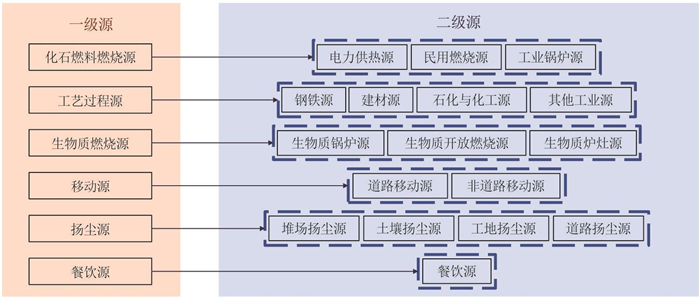
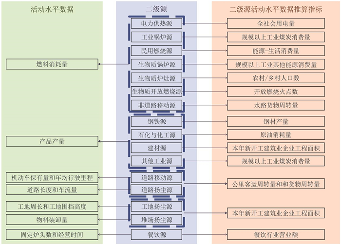
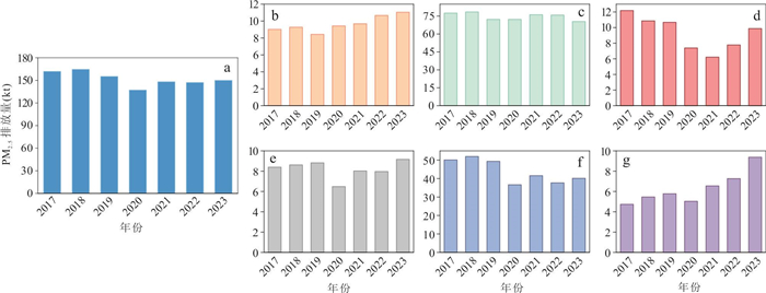
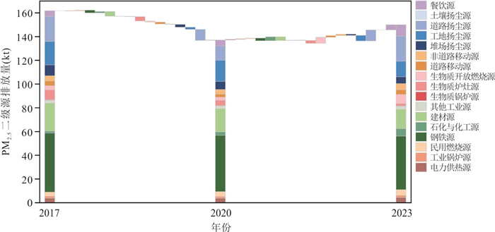
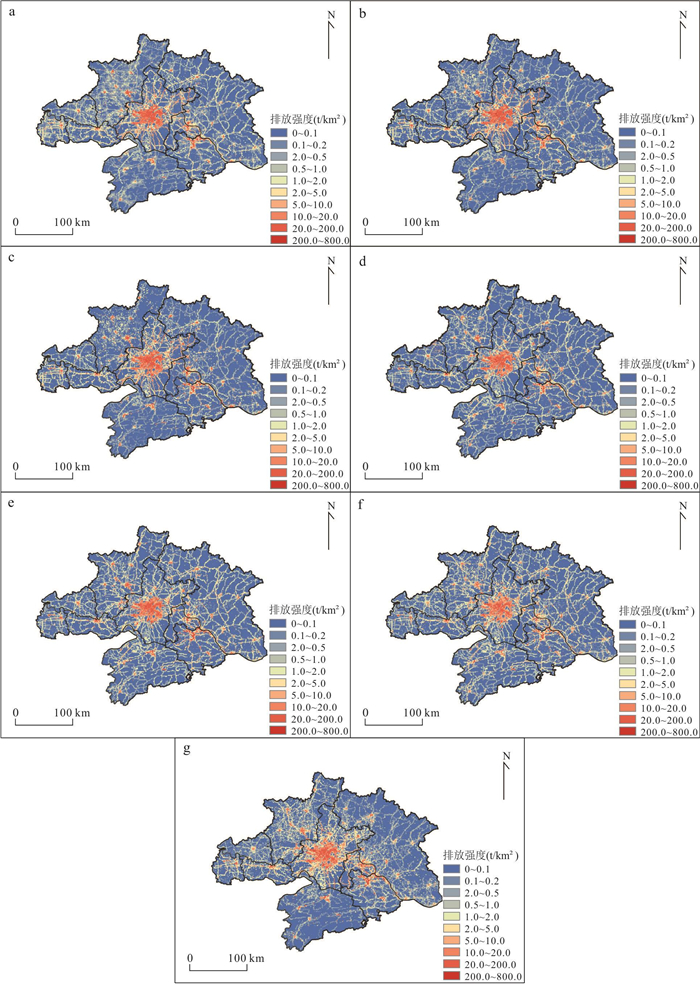
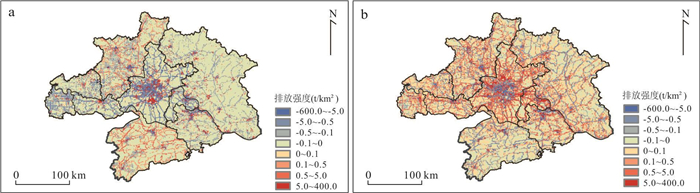
The lack of high spatio-temporal resolution emission inventories for atmospheric fine particulate matter (PM2.5) in the Wuhan metropolitan area limits the accurate simulation and control of regional PM2.5 pollution. In this study, the emission factor method was adopted, integrating point of interest data from Amap as well as relevant allocation indices including population, road network and land use type, etc., to construct a high-spatial-resolution (1 km×1 km) emission inventory of anthropogenic PM2.5 emissions in the region from 2017 to 2023. Its uncertainty was evaluated, and its temporal and spatial evolution patterns were revealed. Results show that the total PM2.5 emissions peaked in 2018 at 164.59 kt, dropped to 137.15 kt in 2020 due to the pandemic, and rebounded to 149.97 kt in 2023. The uncertainty of PM2.5 emissions from various source categories ranged from -31.7% to 42.2%, fossil fuel combustion sources (-13.2% to 35.8%) and process sources (-15.2% to 34.3%) have high uncertainty, while dust sources have the lowest uncertainty (-8.2% to 15.4%). Industrial and dust sources were the main contributors, accounting for 46.5%-52.6% and 26.7%-31.8% of total PM2.5 emissions, respectively. The emission intensity of PM2.5 in urban central area was 600-800 t/km2, which was 40-50 times that in suburban and rural areas. This study can provide reliable high-precision emission inventory data support for improving the accuracy of atmospheric chemistry numerical simulations.