2014 Vol. 39, No. 11
Display Method:
 PDF 276KB
2014, 39(11): 1473-1486.
doi: 10.3799/dqkx.2014.140
Abstract:
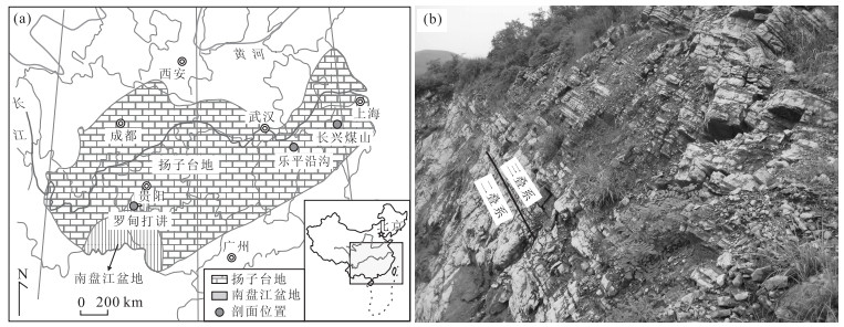
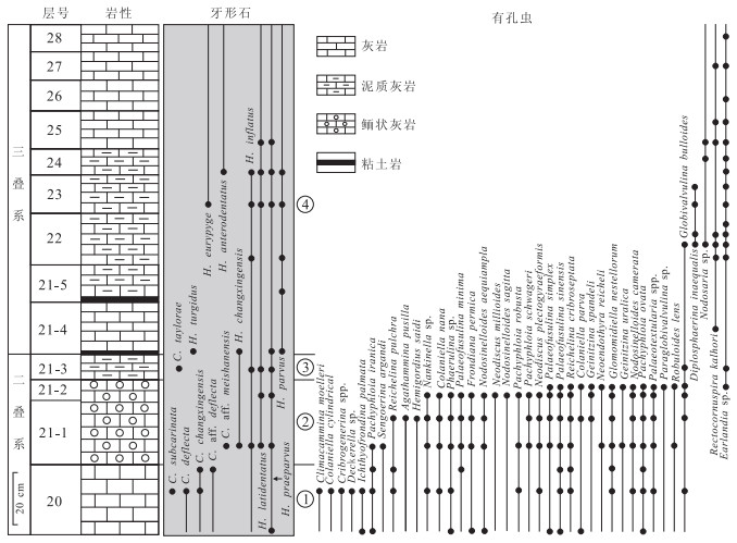
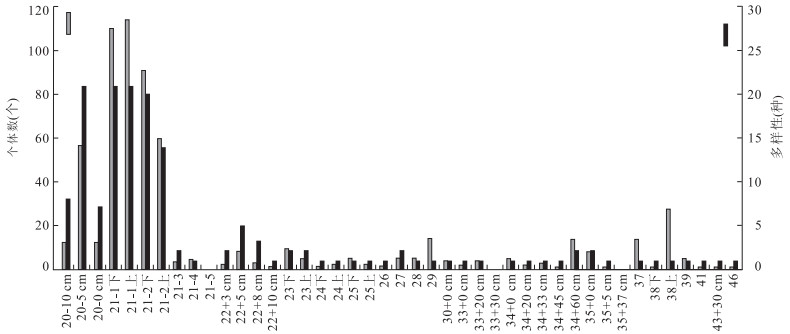
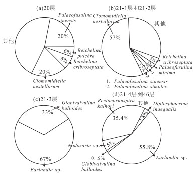
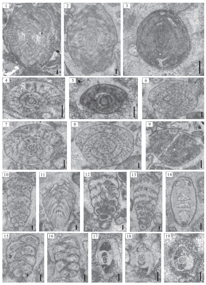
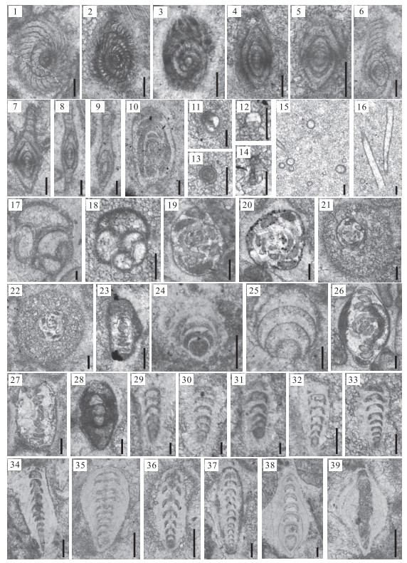
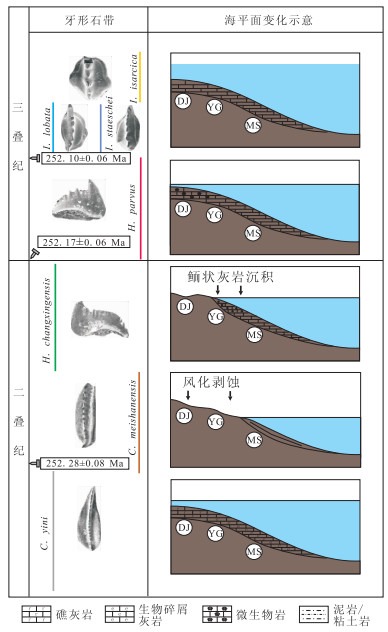
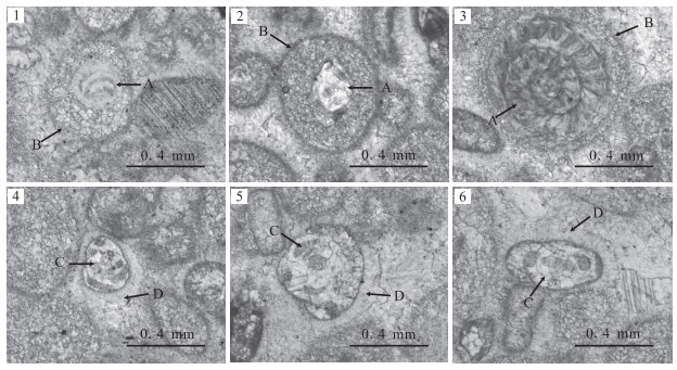
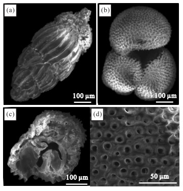
The homogeneous carbonate Permian-Triassic boundary section at Yangou records the integrated extinction process of the shallow marine area, which killed over 90% marine invertebrates. This study of foraminifers explores the extinction pattern and deposition progress during the Paleozoic-Mesozoic transition. In total, 39 species in 27 genera of foraminifers have been identified, including 7 species in 4 genera of fusulinids. The richness and diversity remarkably decrease at the top of Bed 21-2, marking the disappearance horizon. 4 distinct assemblages evolved within the Permian-Triassic boundary beds: the assemblages with low richness and low disparity replaced those with high richness and high disparity. The diversity and assemblage analysis exhibit a rapid decline process at the top of Bed 21-2. Whereas, the mixing of pre-extinction fauna, fusulinids, with post-extinction fauna, Hindeodus changxingensis, within the oolitic beds, implies that the fossil could be reworked to the shoal by the sea level changes. Meanwhile, the coating of foraminifers and aragonite-calcite cement around the grains indicate a catastrophic ocean with high water velocity, elevated microbes and carbonate super-saturation.
The homogeneous carbonate Permian-Triassic boundary section at Yangou records the integrated extinction process of the shallow marine area, which killed over 90% marine invertebrates. This study of foraminifers explores the extinction pattern and deposition progress during the Paleozoic-Mesozoic transition. In total, 39 species in 27 genera of foraminifers have been identified, including 7 species in 4 genera of fusulinids. The richness and diversity remarkably decrease at the top of Bed 21-2, marking the disappearance horizon. 4 distinct assemblages evolved within the Permian-Triassic boundary beds: the assemblages with low richness and low disparity replaced those with high richness and high disparity. The diversity and assemblage analysis exhibit a rapid decline process at the top of Bed 21-2. Whereas, the mixing of pre-extinction fauna, fusulinids, with post-extinction fauna, Hindeodus changxingensis, within the oolitic beds, implies that the fossil could be reworked to the shoal by the sea level changes. Meanwhile, the coating of foraminifers and aragonite-calcite cement around the grains indicate a catastrophic ocean with high water velocity, elevated microbes and carbonate super-saturation.
2014, 39(11): 1487-1499.
doi: 10.3799/dqkx.2014.141
Abstract:
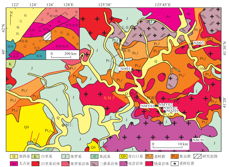
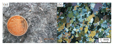
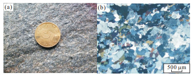
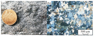
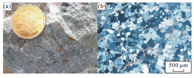
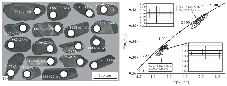
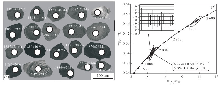
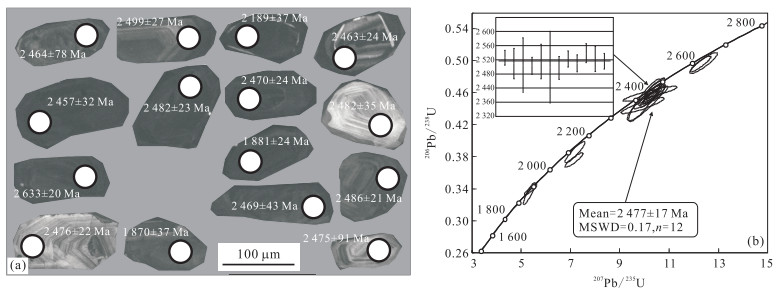
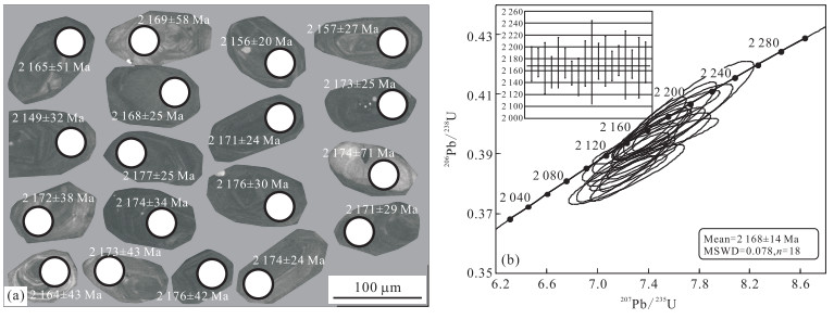
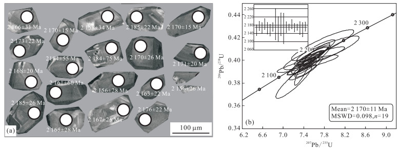
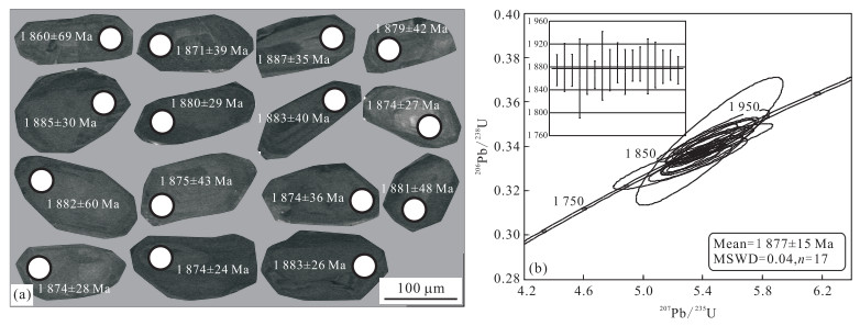
The chronology of volcanic and sedimentary rocks of Ji'an Group, and the granites of the Tonghua area of the Liaoji rift zone by the LA-ICP-MS zircon U-Pb dating are studied in the paper. The results show that the Ji'an Group formed in 2156 to 2189Ma, and subsequently underwent regional metamorphism between 1870 and 1881Ma.Accompanied by the volcanic-sedimentation and the metamorphism of the Ji'an Group, two periods of granitic intrusions occurred; one was at 2156 to 2189Ma during the rifting stage, whereas the other at 1870 to 1881Ma during the orogenic period. In addition, ages of magmatic zircons from the detrital zircons and the inherited zircons peaked at 2471 to 2494Ma and 2633 to 2653Ma, representing two magmatic events of the crystalline basement. Sedimentary provenance of the Ji'an Group was derived from the Archean basement and products of the magmatism during the rifting events.
The chronology of volcanic and sedimentary rocks of Ji'an Group, and the granites of the Tonghua area of the Liaoji rift zone by the LA-ICP-MS zircon U-Pb dating are studied in the paper. The results show that the Ji'an Group formed in 2156 to 2189Ma, and subsequently underwent regional metamorphism between 1870 and 1881Ma.Accompanied by the volcanic-sedimentation and the metamorphism of the Ji'an Group, two periods of granitic intrusions occurred; one was at 2156 to 2189Ma during the rifting stage, whereas the other at 1870 to 1881Ma during the orogenic period. In addition, ages of magmatic zircons from the detrital zircons and the inherited zircons peaked at 2471 to 2494Ma and 2633 to 2653Ma, representing two magmatic events of the crystalline basement. Sedimentary provenance of the Ji'an Group was derived from the Archean basement and products of the magmatism during the rifting events.

2014, 39(11): 1500-1506.
doi: 10.3799/dqkx.2014.142
Abstract:
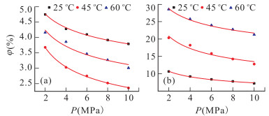
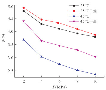
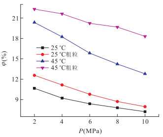
Taking the simulation of indigenous coal and tectonically deformed coal in Pingdingshan coal district as the research object, porosity and permeability of different coal samples under different factors are determined in this paper. The variation trend of porosity and permeability under different factors is analyzed. The experimental results show that four factors analyzed have significant impact on both porosity and permeability of coal. The effect of confining pressure is greater than temperature when confining pressure and temperature work together. And part of experiment data are fitted by the Origin software, concluding with the function relationship of porosity and permeability of coal.
Taking the simulation of indigenous coal and tectonically deformed coal in Pingdingshan coal district as the research object, porosity and permeability of different coal samples under different factors are determined in this paper. The variation trend of porosity and permeability under different factors is analyzed. The experimental results show that four factors analyzed have significant impact on both porosity and permeability of coal. The effect of confining pressure is greater than temperature when confining pressure and temperature work together. And part of experiment data are fitted by the Origin software, concluding with the function relationship of porosity and permeability of coal.
2014, 39(11): 1507-1516.
doi: 10.3799/dqkx.2014.143
Abstract:
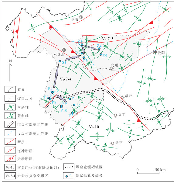
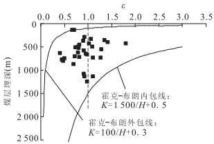
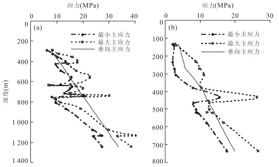
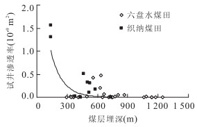
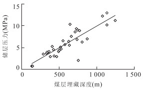
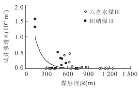
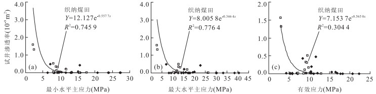
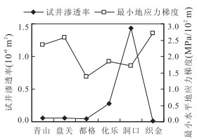
Based on geological analysis of data of 16 testing wells in the Liupanshui and Zhina coalfields, the spatial distribution of coal reservoir permeability and characteristics of in-situ stress in the western Guizhou are discussed, and the control mechanism of buried depth and in-situ stress for coal reservoir permeability is obtained in this study. It is shown that the coal reservoirs have the characteristic of ultra-low and low permeability (< 0.1×10⁻⁹m2), and the permeability of coal reservoir with 0.1×10⁻⁹-1.0×10⁻⁹m2 has considerably large proportion. The type of in-situ stress field is gradually undergoing a possible change from dynamic field in shallow layer to hydrostatic pressure field in deep layer. It has a negative power exponent relationship of coal reservoir permeability and buried depth, but the change of permeability is in accordance with in-situ stress field changed. The permeability of coal reservoir varies in different testing wells, decreasing with the increased in-situ stress and depth, and its spatial distribution has a law of "low-high-low" from SW to NE for the intensity of the stress controlled. The role of coal depth to permeability is supposed to be the in-situ stress in action essentially. The main control mechanism of coal permeability difference is that the pore and fracture tend to compress or close caused by the deformation and fragmentation of coal reservoirs under the influence of high in-situ stress in regional tectonic location of study area.
Based on geological analysis of data of 16 testing wells in the Liupanshui and Zhina coalfields, the spatial distribution of coal reservoir permeability and characteristics of in-situ stress in the western Guizhou are discussed, and the control mechanism of buried depth and in-situ stress for coal reservoir permeability is obtained in this study. It is shown that the coal reservoirs have the characteristic of ultra-low and low permeability (< 0.1×10⁻⁹m2), and the permeability of coal reservoir with 0.1×10⁻⁹-1.0×10⁻⁹m2 has considerably large proportion. The type of in-situ stress field is gradually undergoing a possible change from dynamic field in shallow layer to hydrostatic pressure field in deep layer. It has a negative power exponent relationship of coal reservoir permeability and buried depth, but the change of permeability is in accordance with in-situ stress field changed. The permeability of coal reservoir varies in different testing wells, decreasing with the increased in-situ stress and depth, and its spatial distribution has a law of "low-high-low" from SW to NE for the intensity of the stress controlled. The role of coal depth to permeability is supposed to be the in-situ stress in action essentially. The main control mechanism of coal permeability difference is that the pore and fracture tend to compress or close caused by the deformation and fragmentation of coal reservoirs under the influence of high in-situ stress in regional tectonic location of study area.
2014, 39(11): 1517-1526.
doi: 10.3799/dqkx.2014.144
Abstract:
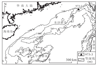
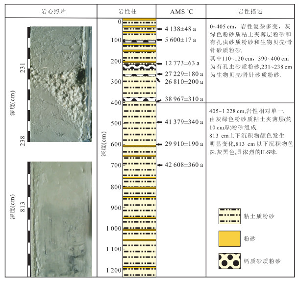
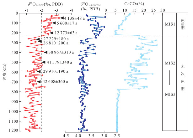
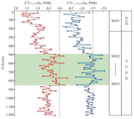
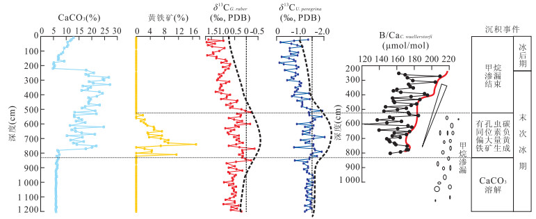
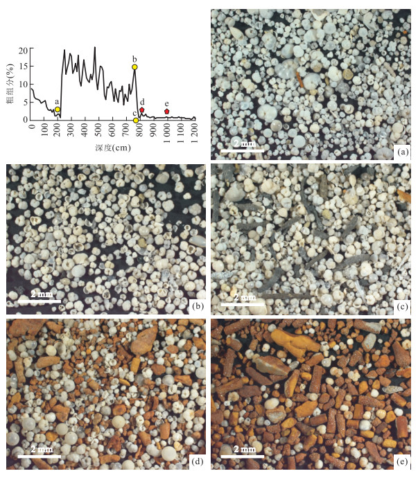
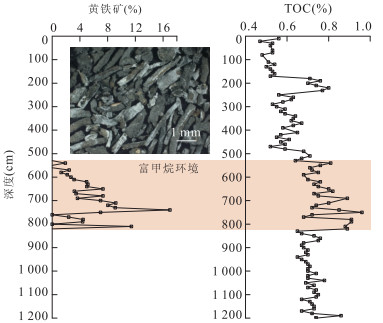
Core 973-3 is located at the potential gas hydrate area on the slope within Dongsha area of the South China Sea, with the water depth of 1026m. According to the sedimentology, chronology, isotope and B/Ca ratio of the foraminiferal tests, carbonate and pyrite content, the light δ13C values of planktonic Globigerinoides ruber and benthic Uvigerina peregrine are found in several core layers with the most negative value of -2.03‰. In the δ13C distinctly depleted layers, the concentration of environmental [CO32-] is relatively low, and the pyrites are abundant up to 17%, which indicates abnormal seepage of methane. Below the δ13C depleted layers, the carbonate intensely dissolves, and its content decreases to the bottom. It suggests that it has probably been caused by the gas hydrate dissociation. The seepage and anaerobic oxidation of methane resulted from the dissociation and release of gas hydrates is the primary reason of the depleted δ13C values of foraminiferal tests, carbonate dissolution and the deposits of enormous pyrites. Methane release events occurred in the last glacial period, which implies that the descending sea level induced the gas hydrate dissociation. According to the δ13C depleted record of foraminiferas, it is concluded that there were at least four times release events of methane, and their intensities were almost at the same level.
Core 973-3 is located at the potential gas hydrate area on the slope within Dongsha area of the South China Sea, with the water depth of 1026m. According to the sedimentology, chronology, isotope and B/Ca ratio of the foraminiferal tests, carbonate and pyrite content, the light δ13C values of planktonic Globigerinoides ruber and benthic Uvigerina peregrine are found in several core layers with the most negative value of -2.03‰. In the δ13C distinctly depleted layers, the concentration of environmental [CO32-] is relatively low, and the pyrites are abundant up to 17%, which indicates abnormal seepage of methane. Below the δ13C depleted layers, the carbonate intensely dissolves, and its content decreases to the bottom. It suggests that it has probably been caused by the gas hydrate dissociation. The seepage and anaerobic oxidation of methane resulted from the dissociation and release of gas hydrates is the primary reason of the depleted δ13C values of foraminiferal tests, carbonate dissolution and the deposits of enormous pyrites. Methane release events occurred in the last glacial period, which implies that the descending sea level induced the gas hydrate dissociation. According to the δ13C depleted record of foraminiferas, it is concluded that there were at least four times release events of methane, and their intensities were almost at the same level.
2014, 39(11): 1527-1538.
doi: 10.3799/dqkx.2014.145
Abstract:
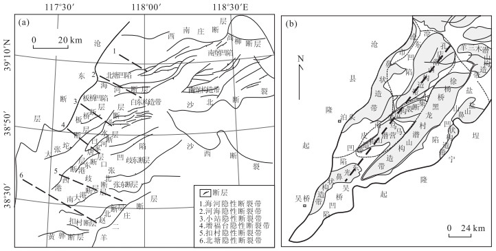
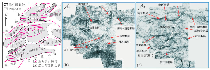
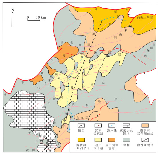
Potential fault zones refer to the fault zones which are influenced by regional or local stress field, basement rift activities, buried hill blocks twist and formed in the cover layer of sedimentary basin. It is a type of fault zone associated with dominant fault, which is often ignored because of the absence of inherent characteristics of dominant faults. It can be identified from 7 aspects below: ① large potential fault zones reflected by en-echelon, intermittent, dislocation of symmetrical arranged small dominant structure (small faults, small folds, fault blocks); ② potential fault zones produced by basement rift system activities; ③ linear, accommodated or side arranged potential fault zones formed by buried hills and sags; ④ potential fault zones reflected by the distribution of sandstone bodies; ⑤ potential fault zones reflected by the distribution, arrangement and strike of reservoirs; ⑥ potential fault zones reflected by coherent body slices; ⑦ potential fault zones formed by local stress field of overlapped fault, segment activities of deep and large faults. Taking the Bohai Bay basin as an example, a classification scheme of potential fault zone is established based on research results at home and abroad, and the characteristics of the potential faults in different levels of tectonic units are discussed. Potential fault zones are proved to be of geological significance in the following aspects. Firstly, it affects the tectonic pattern of basins by adjusting the inhomogeneous extension activities among different faulted blocks in basins and by separating the tectonic units such as sags and uplifts etc.. Secondly, it determines the development and distribution of basin sedimentary facies and influences the distribution range of the sandstone in faulted basin. Thirdly, it yields bead string-like, belt-like, and ring-like oil-gas accumulation zones. The activities of deep faults are prone to induce earthquake and form the potential fault zones on the surface. Therefore, identification and analysis of potential fault zones can be important in reality.
Potential fault zones refer to the fault zones which are influenced by regional or local stress field, basement rift activities, buried hill blocks twist and formed in the cover layer of sedimentary basin. It is a type of fault zone associated with dominant fault, which is often ignored because of the absence of inherent characteristics of dominant faults. It can be identified from 7 aspects below: ① large potential fault zones reflected by en-echelon, intermittent, dislocation of symmetrical arranged small dominant structure (small faults, small folds, fault blocks); ② potential fault zones produced by basement rift system activities; ③ linear, accommodated or side arranged potential fault zones formed by buried hills and sags; ④ potential fault zones reflected by the distribution of sandstone bodies; ⑤ potential fault zones reflected by the distribution, arrangement and strike of reservoirs; ⑥ potential fault zones reflected by coherent body slices; ⑦ potential fault zones formed by local stress field of overlapped fault, segment activities of deep and large faults. Taking the Bohai Bay basin as an example, a classification scheme of potential fault zone is established based on research results at home and abroad, and the characteristics of the potential faults in different levels of tectonic units are discussed. Potential fault zones are proved to be of geological significance in the following aspects. Firstly, it affects the tectonic pattern of basins by adjusting the inhomogeneous extension activities among different faulted blocks in basins and by separating the tectonic units such as sags and uplifts etc.. Secondly, it determines the development and distribution of basin sedimentary facies and influences the distribution range of the sandstone in faulted basin. Thirdly, it yields bead string-like, belt-like, and ring-like oil-gas accumulation zones. The activities of deep faults are prone to induce earthquake and form the potential fault zones on the surface. Therefore, identification and analysis of potential fault zones can be important in reality.
2014, 39(11): 1539-1546.
doi: 10.3799/dqkx.2014.146
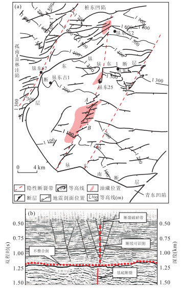
Abstract:
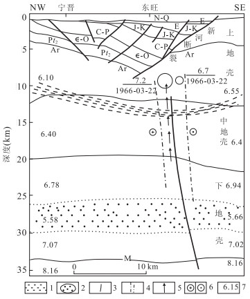
It is proved that fault possesses a typical characteristic of vertical segmentation growth if there is competent difference by field observation, typical seismic analysis and physical modeling. Fault evolution can be divided into three stages by competent difference: formation of lower fault, segmentation of upper and lower faults and formation of throughgoing fault. Taking Sanzhao depression as an example, rock mechanical properties and fault related fold theories prove that there widely exist faults in sandstone layer of Fuyang oil layer, whose propagation is stopped by mudstone in Qingshankou Formation Ⅰ member, leading to the vertical segmentation growth of fault. Combining fine reservoir anatomy, it can be concluded that the main oil source faults of the "reversed" migration in Fuyang oil layer must have been active in hydrocarbon migration and accumulation period, connecting oil source and reservoirs, and featuring vertical segmentation growth in Sanzhao depression.
It is proved that fault possesses a typical characteristic of vertical segmentation growth if there is competent difference by field observation, typical seismic analysis and physical modeling. Fault evolution can be divided into three stages by competent difference: formation of lower fault, segmentation of upper and lower faults and formation of throughgoing fault. Taking Sanzhao depression as an example, rock mechanical properties and fault related fold theories prove that there widely exist faults in sandstone layer of Fuyang oil layer, whose propagation is stopped by mudstone in Qingshankou Formation Ⅰ member, leading to the vertical segmentation growth of fault. Combining fine reservoir anatomy, it can be concluded that the main oil source faults of the "reversed" migration in Fuyang oil layer must have been active in hydrocarbon migration and accumulation period, connecting oil source and reservoirs, and featuring vertical segmentation growth in Sanzhao depression.
2014, 39(11): 1547-1554,1592.
doi: 10.3799/dqkx.2014.147
Abstract:
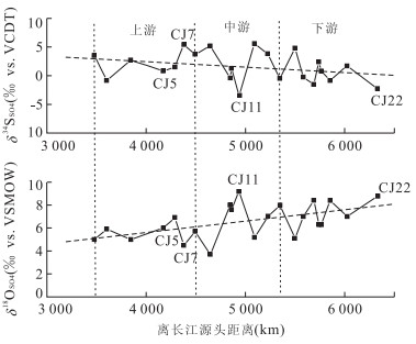
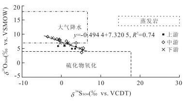
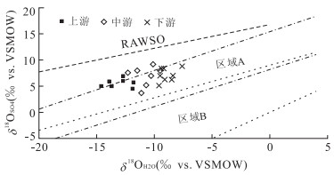
Crustal weathering by sulfuric acid and its relationship with carbon cycling is a subject of greatest concern in the domain of global carbon cycling, with its key issue of the identification of riverine sulfate sources. In this study, stable sulfur and oxygen isotope compositions of riverine sulfate in the mainstream of the Yangtze River during rainy season are determined to trace the riverine sulfate sources and controlling factors. The SO42-concentration keeps increasing with ever-increasing annual growth rate. The isotope compositions of dissolved sulfate in the Yangze River range from -3.5‰ to 5.6‰ for δ34SSO4 and from 3.7‰ to 9.2‰ for δ18OSO4, showing a significantly negative linear correlation between δ34SSO4 and δ18OSO4. The tendency of increased δ18OSO4 values from upstream to downstream is controlled by δ18OH2O values of the Yangtze River water. It is indicated that atmospheric acid deposition and sulfide oxidation are dominant sources of dissolved sulfate in the Yangze River. This study offers theoretical basis which facilitates further environmental explorations for chemical weathering of carbonate and carbon cycling.
Crustal weathering by sulfuric acid and its relationship with carbon cycling is a subject of greatest concern in the domain of global carbon cycling, with its key issue of the identification of riverine sulfate sources. In this study, stable sulfur and oxygen isotope compositions of riverine sulfate in the mainstream of the Yangtze River during rainy season are determined to trace the riverine sulfate sources and controlling factors. The SO42-concentration keeps increasing with ever-increasing annual growth rate. The isotope compositions of dissolved sulfate in the Yangze River range from -3.5‰ to 5.6‰ for δ34SSO4 and from 3.7‰ to 9.2‰ for δ18OSO4, showing a significantly negative linear correlation between δ34SSO4 and δ18OSO4. The tendency of increased δ18OSO4 values from upstream to downstream is controlled by δ18OH2O values of the Yangtze River water. It is indicated that atmospheric acid deposition and sulfide oxidation are dominant sources of dissolved sulfate in the Yangze River. This study offers theoretical basis which facilitates further environmental explorations for chemical weathering of carbonate and carbon cycling.
2014, 39(11): 1555-1565.
doi: 10.3799/dqkx.2014.148
Abstract:
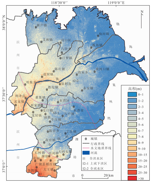
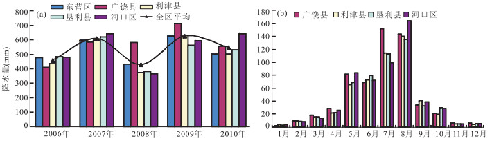
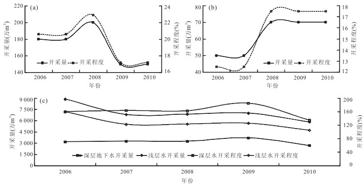
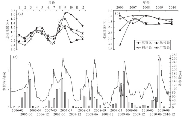
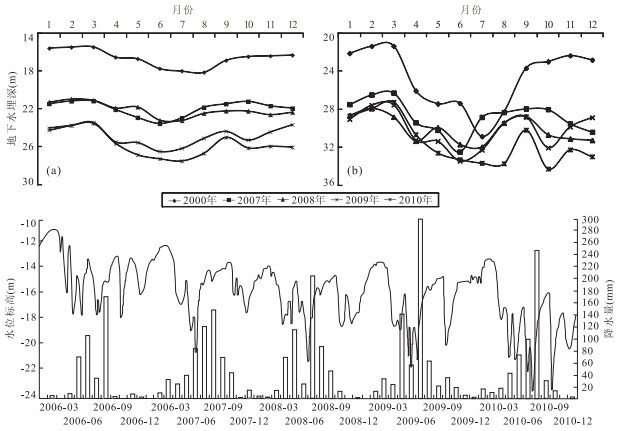
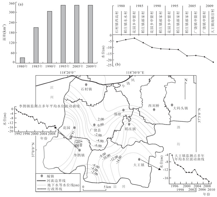
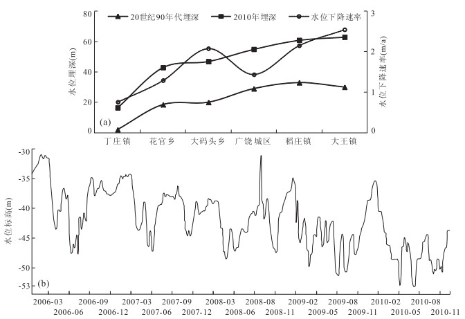
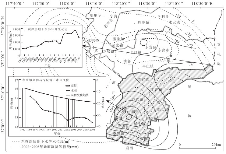
To analyze the groundwater dynamic and the relationship between groundwater level and land subsidence in the Yellow River Delta, drastic groundwater level depression and serious land subsidence have been researched by monitoring data of groundwater level and land subsidence for years. Persistent groundwater overexploitation has resulted in groundwater depression cones in both shallow and deep aquifers successively. The deep groundwater level decline rate of cone centers is 2 to 3m/a. In recent years, Dongying and Guangrao exhibit a typical subsidence area with cumulative settlement and subsidence rates of 155.1mm, 28.2mm/a and 356.0mm, 64.7mm/a, respectively. Using GIS and mathematical statistics, it is found that configuration of the subsidence cone is basically identical to the shape of the deep groundwater depression cone, and there exists a significant linear positive correlation between deep groundwater level and elevation in deep groundwater depression cone, with the correlation coefficient of 0.92. The deep groundwater overexploitation has been the most essential factor to land subsidence. The third compressed layer has become the main contribution layer of land subsidence in well-irrigated area. Because water level at centers of deep groundwater depression cone has fallen below critical water level of the third confined aquifer, land subsidence is becoming more and more serious.
To analyze the groundwater dynamic and the relationship between groundwater level and land subsidence in the Yellow River Delta, drastic groundwater level depression and serious land subsidence have been researched by monitoring data of groundwater level and land subsidence for years. Persistent groundwater overexploitation has resulted in groundwater depression cones in both shallow and deep aquifers successively. The deep groundwater level decline rate of cone centers is 2 to 3m/a. In recent years, Dongying and Guangrao exhibit a typical subsidence area with cumulative settlement and subsidence rates of 155.1mm, 28.2mm/a and 356.0mm, 64.7mm/a, respectively. Using GIS and mathematical statistics, it is found that configuration of the subsidence cone is basically identical to the shape of the deep groundwater depression cone, and there exists a significant linear positive correlation between deep groundwater level and elevation in deep groundwater depression cone, with the correlation coefficient of 0.92. The deep groundwater overexploitation has been the most essential factor to land subsidence. The third compressed layer has become the main contribution layer of land subsidence in well-irrigated area. Because water level at centers of deep groundwater depression cone has fallen below critical water level of the third confined aquifer, land subsidence is becoming more and more serious.

2014, 39(11): 1566-1574.
doi: 10.3799/dqkx.2014.149
Abstract:
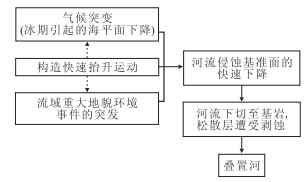
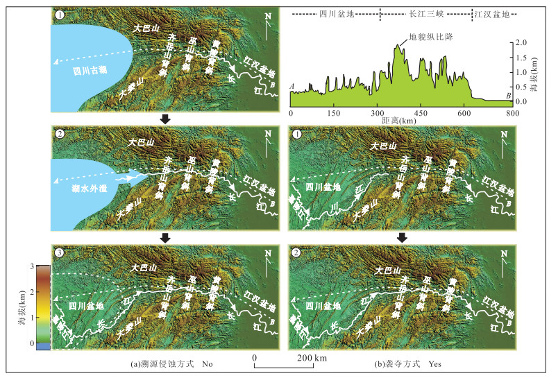
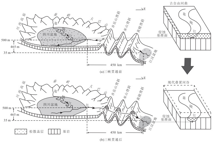
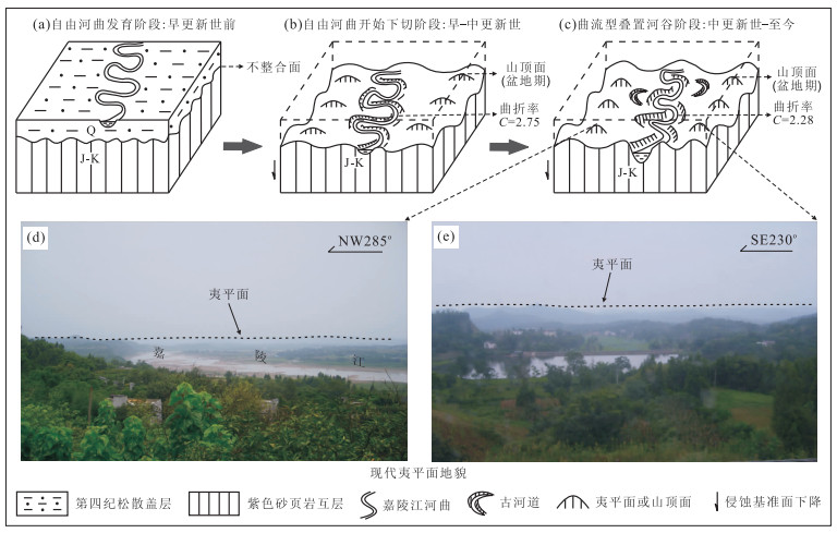
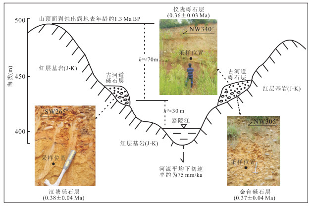
In order to define the formation of the Jialing meander shape-superimposed valley and response to the regional geological environment evolution, the regional geological background, together with the evolution model of water system are explored. It is found that origin of the meander shape-superimposed valley maybe controlled by cut-through of the Three Gorges. Water systems of the Sichuan basin and the Jianghan basin had developed separately due to the ancient watershed before the cut-through of the Three Gorges until the Jianghan basin drainage cut through the ancient watershed, captured the western drainage of watershed because of quick erosion rate in the eastern Jianghan basin, and the two drainages were unified at last. Ancient meander of the Jialing River was fast undercut, inset the bed rock and finally developed the meander shape-superimposed valley, the spectacular landscape. Based on ESR (electron spin resonance dating) ages of river sediments in the gravel layers, we believe that cut-through of the Three Gorges happened approximately in the Early-Middle Pleistocene. The cut-through maybe closely related with the "Kunlun-Huanghe Movement", which happened in this period because of the strong crustal activity in the Quaternary.
In order to define the formation of the Jialing meander shape-superimposed valley and response to the regional geological environment evolution, the regional geological background, together with the evolution model of water system are explored. It is found that origin of the meander shape-superimposed valley maybe controlled by cut-through of the Three Gorges. Water systems of the Sichuan basin and the Jianghan basin had developed separately due to the ancient watershed before the cut-through of the Three Gorges until the Jianghan basin drainage cut through the ancient watershed, captured the western drainage of watershed because of quick erosion rate in the eastern Jianghan basin, and the two drainages were unified at last. Ancient meander of the Jialing River was fast undercut, inset the bed rock and finally developed the meander shape-superimposed valley, the spectacular landscape. Based on ESR (electron spin resonance dating) ages of river sediments in the gravel layers, we believe that cut-through of the Three Gorges happened approximately in the Early-Middle Pleistocene. The cut-through maybe closely related with the "Kunlun-Huanghe Movement", which happened in this period because of the strong crustal activity in the Quaternary.
2014, 39(11): 1575-1583.
doi: 10.3799/dqkx.2014.150
Abstract:
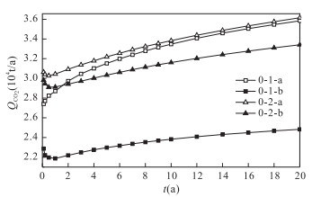
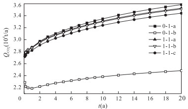
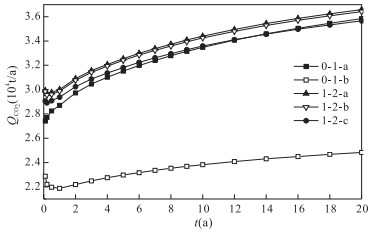
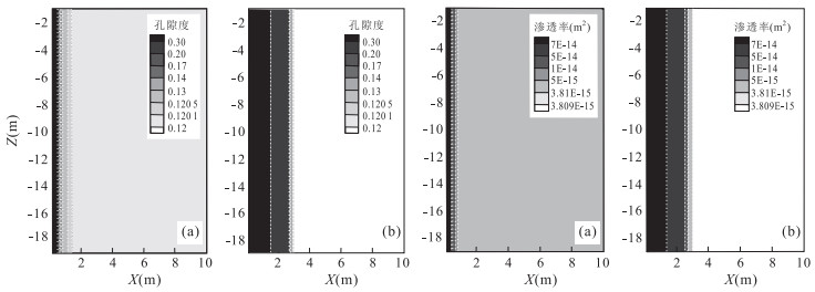
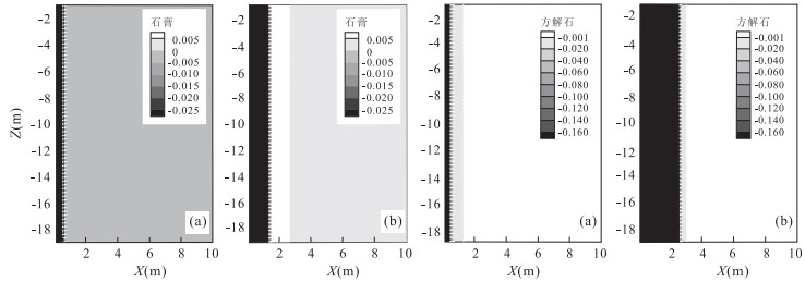
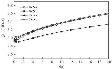
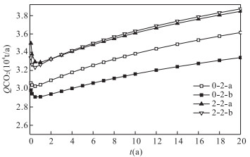
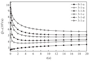
Injectivity is a crucial technical and economical issue for CO2 geological storage projects due to large volumes of CO2 to be stored. Assessment and enhancement of CO2 injectivity in ubiquitous low-permeability reservoirs in the continental sedimentary basins of China is of great significance to the application and development of carbon capture and storage (CCS) in China. Numerical simulation was carried out to investigate the potential and enhancement of CO2 injectivity in high-salinity and low-permeability aquifers by taking Jiangling depression of Jianghan basin as the study area. The results show that pre-injection of freshwater and low-salinity saline water can effectively mitigate salt precipitation around the CO2 injection well at different levels; pre-injection of CO2-saturation solution and diluted HCl solution can significantly improve the porosity and permeability values and enhance CO2 injectivity. However, it is difficult to achieve a significant increase in CO2 injection rate in a short time due to the limited migration distance resulted from the low-permeability nature. Hydraulic fracturing measures can significantly increase CO2 injectivity and the improved capacity largely depends on fracturing half-length and fracturing degree. Therefore, for a single vertical well, it is possible to achieve the injection of hundreds of thousands of tons of CO2 per year to low-permeability reservoirs by adopting hydraulic fracturing measures and multi-layer injection.
Injectivity is a crucial technical and economical issue for CO2 geological storage projects due to large volumes of CO2 to be stored. Assessment and enhancement of CO2 injectivity in ubiquitous low-permeability reservoirs in the continental sedimentary basins of China is of great significance to the application and development of carbon capture and storage (CCS) in China. Numerical simulation was carried out to investigate the potential and enhancement of CO2 injectivity in high-salinity and low-permeability aquifers by taking Jiangling depression of Jianghan basin as the study area. The results show that pre-injection of freshwater and low-salinity saline water can effectively mitigate salt precipitation around the CO2 injection well at different levels; pre-injection of CO2-saturation solution and diluted HCl solution can significantly improve the porosity and permeability values and enhance CO2 injectivity. However, it is difficult to achieve a significant increase in CO2 injection rate in a short time due to the limited migration distance resulted from the low-permeability nature. Hydraulic fracturing measures can significantly increase CO2 injectivity and the improved capacity largely depends on fracturing half-length and fracturing degree. Therefore, for a single vertical well, it is possible to achieve the injection of hundreds of thousands of tons of CO2 per year to low-permeability reservoirs by adopting hydraulic fracturing measures and multi-layer injection.
2014, 39(11): 1584-1592.
doi: 10.3799/dqkx.2014.151
Abstract:
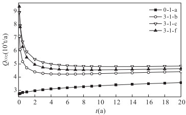
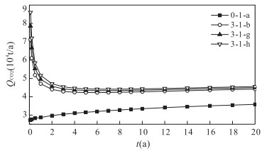
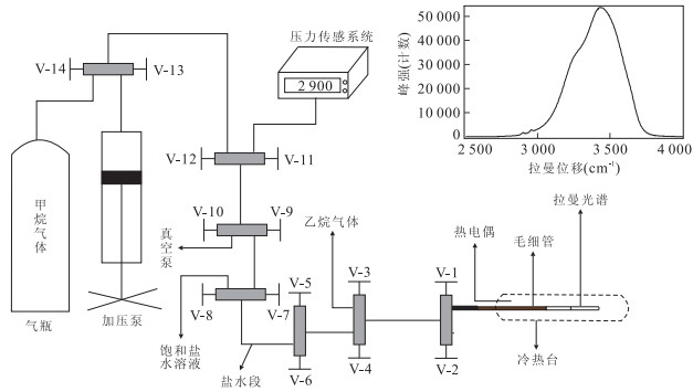
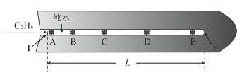
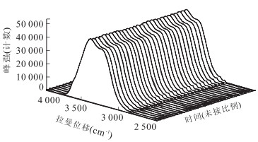
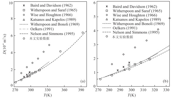
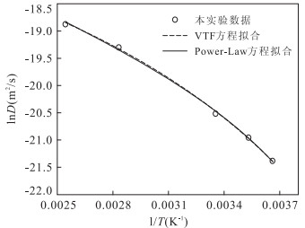
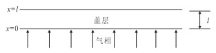
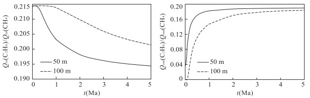
Ethane and methane are two main components of natural gas. Accurate diffusion coefficients at high temperature for ethane and methane are the key to calculate the diffusion and fractionation of gases in deep natural gas reservoirs, especially in unfractured shale and other geological materials with low permeability. However, the diffusion coefficients for ethane at pressures and temperatures near the reservoir conditions are scarce in the literature. In this study, diffusive transfer of ethane in water at 20MPa and from 273 to 393K was observed in a high-pressure optical capillary cell via Raman spectroscopy. Diffusion coefficients were then determined by the least-square method. The relationship between diffusion coefficients [D(C2H6) in m2/s] and temperature (T in K) was derived with Speedy-Angell power-law equation as: D(C2H6)=D0[(T/Ts)-1]γ, where D0=13.8055×10⁻⁹m2/s, Ts=237.4K, γ=1.7397. The diffusion coefficients of ethane are much smaller than those of methane at the same condition. The amount of methane and ethane diffused through some thick low permeability layers are calculated and the results show that such diffusivity difference can cause a significant fractionation of methane and ethane in thick shale layer.
Ethane and methane are two main components of natural gas. Accurate diffusion coefficients at high temperature for ethane and methane are the key to calculate the diffusion and fractionation of gases in deep natural gas reservoirs, especially in unfractured shale and other geological materials with low permeability. However, the diffusion coefficients for ethane at pressures and temperatures near the reservoir conditions are scarce in the literature. In this study, diffusive transfer of ethane in water at 20MPa and from 273 to 393K was observed in a high-pressure optical capillary cell via Raman spectroscopy. Diffusion coefficients were then determined by the least-square method. The relationship between diffusion coefficients [D(C2H6) in m2/s] and temperature (T in K) was derived with Speedy-Angell power-law equation as: D(C2H6)=D0[(T/Ts)-1]γ, where D0=13.8055×10⁻⁹m2/s, Ts=237.4K, γ=1.7397. The diffusion coefficients of ethane are much smaller than those of methane at the same condition. The amount of methane and ethane diffused through some thick low permeability layers are calculated and the results show that such diffusivity difference can cause a significant fractionation of methane and ethane in thick shale layer.


2014, 39(11): 1593-1598,1634.
doi: 10.3799/dqkx.2014.152
Abstract:
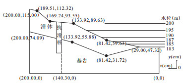
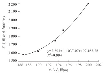
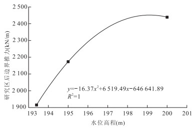
To study the deformation and stability in the condition of water level fluctuation and rainfall, the frame type model test was taken on the sliding body I of Majiagou landslide with a ratio of 1∶40.The shapes of sliding body and sliding zone in the front of the anti-slide pile were changed in the 2.0m×1.0m×1.5m frame to make sure that the stability coefficients were the same before and after being generalized. The reduction factors of the boundary thrust in the different water levels corresponding natural conditions were put forward. The rate of water level rise and fall was changed in order to guarantee equal stability coefficients, and the numerical simulation results show that the rate of 0.7m/d ranging from 183 to 204m is in accordance with the actual landslide, and the rationality of the model is verified.
To study the deformation and stability in the condition of water level fluctuation and rainfall, the frame type model test was taken on the sliding body I of Majiagou landslide with a ratio of 1∶40.The shapes of sliding body and sliding zone in the front of the anti-slide pile were changed in the 2.0m×1.0m×1.5m frame to make sure that the stability coefficients were the same before and after being generalized. The reduction factors of the boundary thrust in the different water levels corresponding natural conditions were put forward. The rate of water level rise and fall was changed in order to guarantee equal stability coefficients, and the numerical simulation results show that the rate of 0.7m/d ranging from 183 to 204m is in accordance with the actual landslide, and the rationality of the model is verified.
2014, 39(11): 1599-1606.
doi: 10.3799/dqkx.2014.153
Abstract:
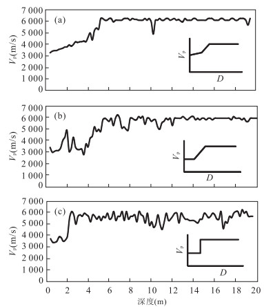
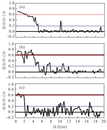
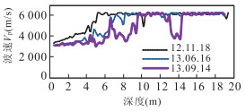
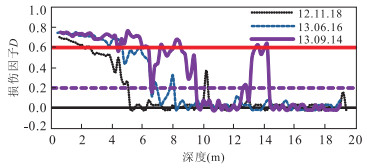
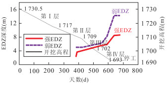
Excavation Damaged Zone (EDZ) assessment is important for the design, execution and operation of modern underground engineering. However, it is very difficult to determine EDZ because of the complexity of lithology, geostress, excavation method, cavern size and shape, etc.. Based on its definition, EDZ is subdivided into excavation highly damaged zone (EHDZ), excavation slightly damaged zone (ESDZ) and basically undamaged zone in this paper. Acoustic wave velocity method is suggested to determine EDZ. The acoustic wave curves are classified into type Ⅰ, type Ⅱ and type Ⅲ. EHDZ and ESDZ can be qualitatively determined by characteristic points of acoustic wave curves. A damage factor D calculated by the acoustic wave velocities is adapted to quantitatively assess EDZ. It is found that the comprehensive method and index provide us a good assessment of EDZ for underground caverns.
Excavation Damaged Zone (EDZ) assessment is important for the design, execution and operation of modern underground engineering. However, it is very difficult to determine EDZ because of the complexity of lithology, geostress, excavation method, cavern size and shape, etc.. Based on its definition, EDZ is subdivided into excavation highly damaged zone (EHDZ), excavation slightly damaged zone (ESDZ) and basically undamaged zone in this paper. Acoustic wave velocity method is suggested to determine EDZ. The acoustic wave curves are classified into type Ⅰ, type Ⅱ and type Ⅲ. EHDZ and ESDZ can be qualitatively determined by characteristic points of acoustic wave curves. A damage factor D calculated by the acoustic wave velocities is adapted to quantitatively assess EDZ. It is found that the comprehensive method and index provide us a good assessment of EDZ for underground caverns.
2014, 39(11): 1607-1616.
doi: 10.3799/dqkx.2014.154
Abstract:
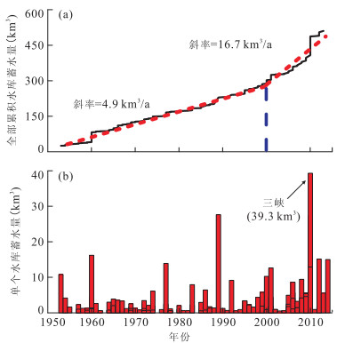
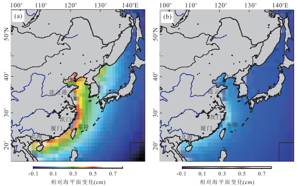
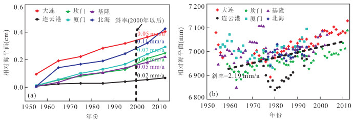
The spatial-temporal characteristics of water impoundment of large reservoirs in China are analyzed in this study. The results show that 697km3 of water has been impounded in the large reservoirs since 1950, which amounts to 83.3% and 6.5% of the total reservoir storage capacity in China and the whole world, respectively. The numbers of large reservoirs and water storage capacity have been accelerating since 2000, and rate of the capacity change is 16.7km3/a, much higher than the increase from 1950 to 2000 at 4.9km3/a. Meanwhile, terrestrial water storage in the south of the Yangtze River basin is estimated by using satellite gravity data by the Gravity Recovery and Climate Experiment (GRACE) after 2000, showing that the estimate by GRACE is only 63% of total reservoir volume changes, and the difference between GRACE and real reservoir storage variations suggests a long-term trend of groundwater in this area. Based on location and capacity of the large reservoirs and sea level equation, the dam-induced spatial distributions of coastal relative sea level (RSL) are calculated. The results depict that the RSL caused the water impounded behind dams rise most quickly in the Bohai Sea and southeast coastal areas, and the maximum of the RSL is approximately about 8mm. Besides, impact of the water impoundment on the RSL mainly concentrates in the southeast coast, where the rise of the RSL is approximately about 2 to 3mm since 2000. And the rising rate of the RSL in the China coastal tide gauge locations is 0.02-0.11mm/a.
The spatial-temporal characteristics of water impoundment of large reservoirs in China are analyzed in this study. The results show that 697km3 of water has been impounded in the large reservoirs since 1950, which amounts to 83.3% and 6.5% of the total reservoir storage capacity in China and the whole world, respectively. The numbers of large reservoirs and water storage capacity have been accelerating since 2000, and rate of the capacity change is 16.7km3/a, much higher than the increase from 1950 to 2000 at 4.9km3/a. Meanwhile, terrestrial water storage in the south of the Yangtze River basin is estimated by using satellite gravity data by the Gravity Recovery and Climate Experiment (GRACE) after 2000, showing that the estimate by GRACE is only 63% of total reservoir volume changes, and the difference between GRACE and real reservoir storage variations suggests a long-term trend of groundwater in this area. Based on location and capacity of the large reservoirs and sea level equation, the dam-induced spatial distributions of coastal relative sea level (RSL) are calculated. The results depict that the RSL caused the water impounded behind dams rise most quickly in the Bohai Sea and southeast coastal areas, and the maximum of the RSL is approximately about 8mm. Besides, impact of the water impoundment on the RSL mainly concentrates in the southeast coast, where the rise of the RSL is approximately about 2 to 3mm since 2000. And the rising rate of the RSL in the China coastal tide gauge locations is 0.02-0.11mm/a.
2014, 39(11): 1617-1624.
doi: 10.3799/dqkx.2014.155
Abstract:
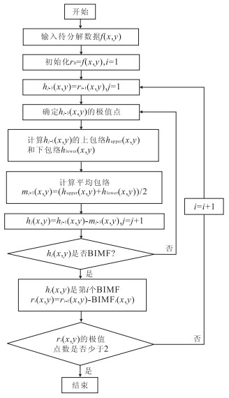
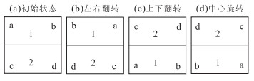
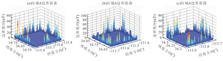
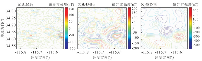
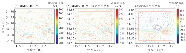
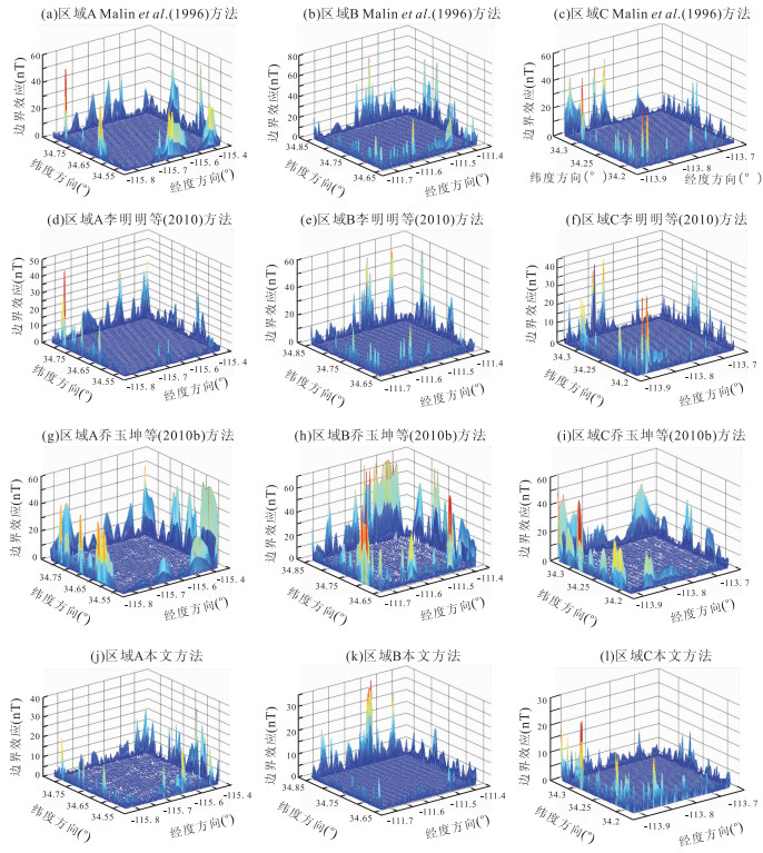
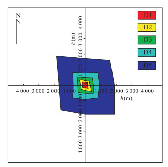
A boundary compensation method based on bi-dimensional empirical mode decomposition (BEMD) is proposed in this paper to address the boundary effect in preparation of geomagnetic navigation reference map. The local geomagnetic anomaly data are firstly decomposed into components with different scales with BEMD; then for small scale ones instant amplitude and frequency are computed with total Hilbert transform, and the boundary is compensated with self-sampling and feature-matching; whereas for the large scale ones, trigonometric function model is conducted and used to compute the values outside the boundary. After the compensation of local dataset, rectangular harmonic model is used to prepare geomagnetic map. Experimental results indicate that BEMD method could better compress the boundary effect of rectangular harmonic analysis, and improve the mapping precision steadily in comparison with other existing methods.
A boundary compensation method based on bi-dimensional empirical mode decomposition (BEMD) is proposed in this paper to address the boundary effect in preparation of geomagnetic navigation reference map. The local geomagnetic anomaly data are firstly decomposed into components with different scales with BEMD; then for small scale ones instant amplitude and frequency are computed with total Hilbert transform, and the boundary is compensated with self-sampling and feature-matching; whereas for the large scale ones, trigonometric function model is conducted and used to compute the values outside the boundary. After the compensation of local dataset, rectangular harmonic model is used to prepare geomagnetic map. Experimental results indicate that BEMD method could better compress the boundary effect of rectangular harmonic analysis, and improve the mapping precision steadily in comparison with other existing methods.
2014, 39(11): 1625-1634.
doi: 10.3799/dqkx.2014.156
Abstract:
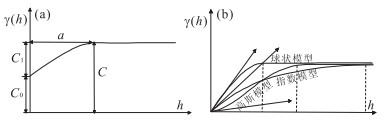
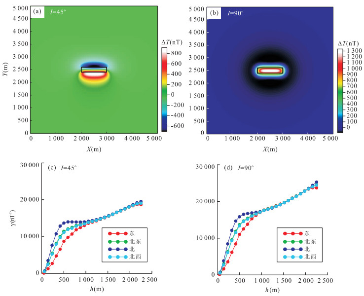
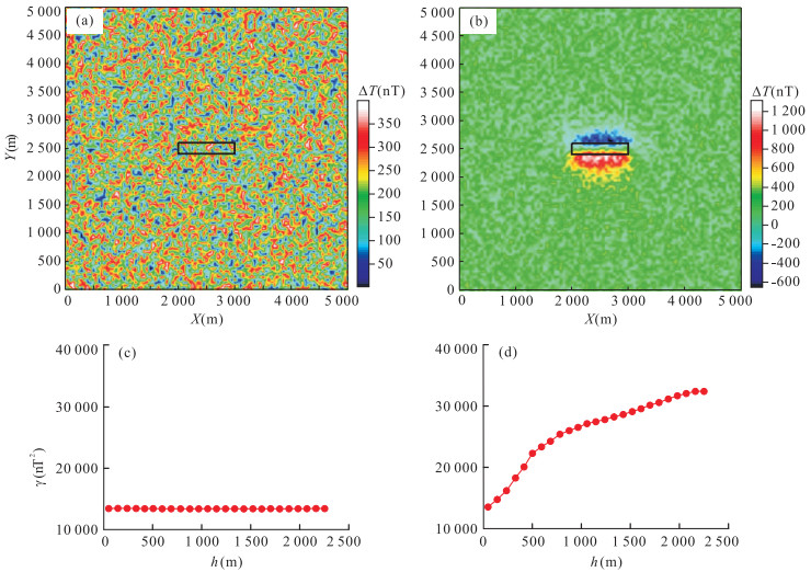
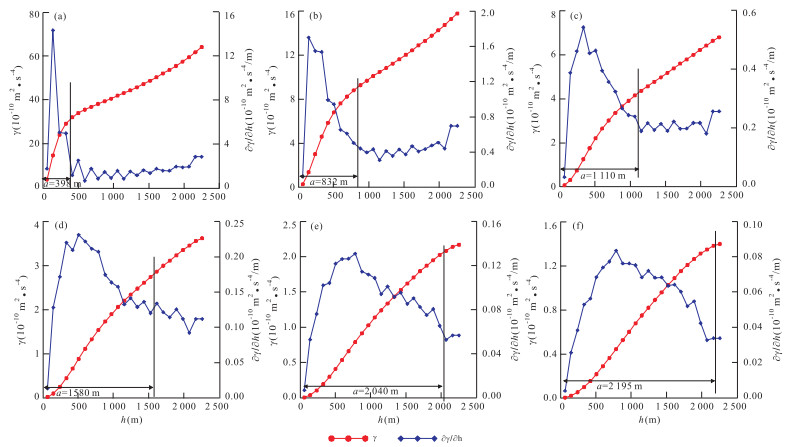
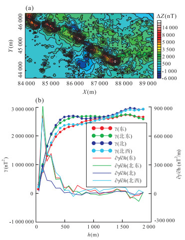
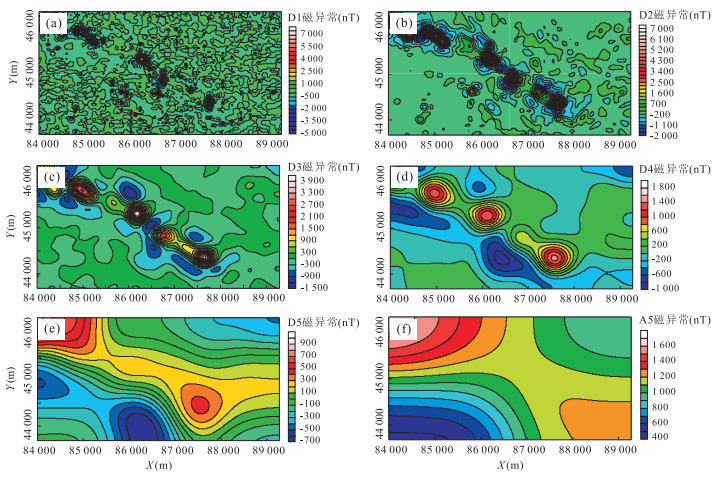
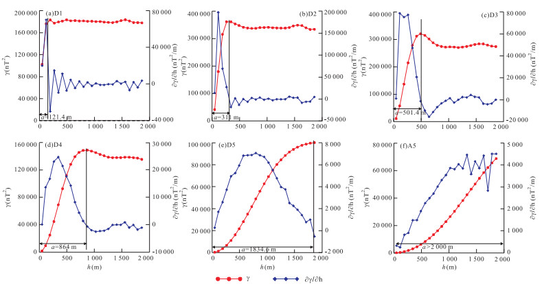
The variogram is used to investigate the regional variation characteristics of gravity and magnetic fields in this study. The range of variogram reflects the coherent area; the nugget effect represents the random disturbance; and the sill means the variation degree. The theoretical simulations involving gravity and magnetic fields show that the coherent range of gravity field is larger than that of magnetic field. The range of potential gravity and magnetic field is mainly determined by the depth of field sources. The variogram for shallow sources is approximate to be a spherical or exponential model, while with the increase of the depth, it nearly becomes a more continuously Gaussian model. The depth of magnetic source is approximately equal to the half of the range, whereas the depth of gravity source is approximately equal to one quarter of the range. The real example of the vertical component magnetic anomaly of the Daye iron-ore deposit in Hubei has geometric anisotropy striking northwest-southeast direction. The variogram reveals that the average depth of magnetite orebodies is about 250m. The decomposed details and approximations of magnetic anomaly using wavelet transform have the coordinate geometric anisotropy. And the estimated depths using variogram ranges are in agreement with those gained by power spectrum method.
The variogram is used to investigate the regional variation characteristics of gravity and magnetic fields in this study. The range of variogram reflects the coherent area; the nugget effect represents the random disturbance; and the sill means the variation degree. The theoretical simulations involving gravity and magnetic fields show that the coherent range of gravity field is larger than that of magnetic field. The range of potential gravity and magnetic field is mainly determined by the depth of field sources. The variogram for shallow sources is approximate to be a spherical or exponential model, while with the increase of the depth, it nearly becomes a more continuously Gaussian model. The depth of magnetic source is approximately equal to the half of the range, whereas the depth of gravity source is approximately equal to one quarter of the range. The real example of the vertical component magnetic anomaly of the Daye iron-ore deposit in Hubei has geometric anisotropy striking northwest-southeast direction. The variogram reveals that the average depth of magnetite orebodies is about 250m. The decomposed details and approximations of magnetic anomaly using wavelet transform have the coordinate geometric anisotropy. And the estimated depths using variogram ranges are in agreement with those gained by power spectrum method.

2014, 39(11): 1635-1643.
doi: 10.3799/dqkx.2014.157
Abstract:
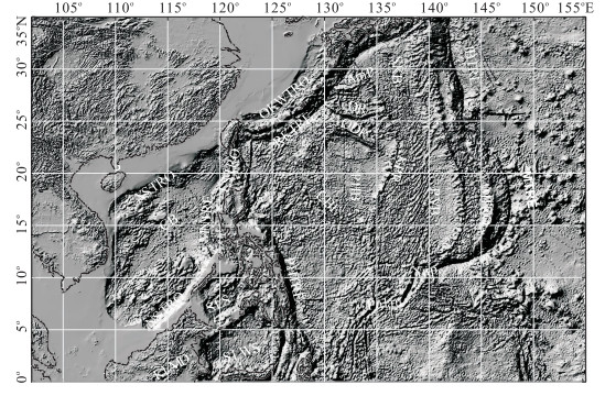
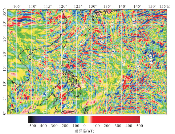
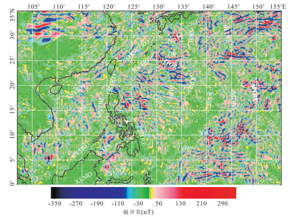
In this paper, we analyze characteristics of magnetic anomalies calculated from NGDC720 geomagnetic model in the Philippine Sea plate and then decompose magnetic anomalies into the shallow and the deep components. Further, we interpret the causes of magnetic anomalies in the study area. Magnetic anomalies in the Philippine Sea plate not only show tectonic features in the shallow part of the lithosphere, also imply the deep structure information. In the Philippine basin and Daito tectonic zone, shallow magnetic anomalies inherit deep structural features better and magnetic characteristics in these regions reflect the integrity of the lithosphere. The shallow magnetic anomalies in Shikoku and Parece Vela basin show the characteristics corresponded with spreading axis during about 10Ma and magnetic anomaly trends do not agree with those of the seafloor structures. In the Parece Vela basin, the deep anomalies show a consistency with those in Philippine basin, which indicates that Parece Vela basin might have undergone a similar evolution of the Philippine basin.
In this paper, we analyze characteristics of magnetic anomalies calculated from NGDC720 geomagnetic model in the Philippine Sea plate and then decompose magnetic anomalies into the shallow and the deep components. Further, we interpret the causes of magnetic anomalies in the study area. Magnetic anomalies in the Philippine Sea plate not only show tectonic features in the shallow part of the lithosphere, also imply the deep structure information. In the Philippine basin and Daito tectonic zone, shallow magnetic anomalies inherit deep structural features better and magnetic characteristics in these regions reflect the integrity of the lithosphere. The shallow magnetic anomalies in Shikoku and Parece Vela basin show the characteristics corresponded with spreading axis during about 10Ma and magnetic anomaly trends do not agree with those of the seafloor structures. In the Parece Vela basin, the deep anomalies show a consistency with those in Philippine basin, which indicates that Parece Vela basin might have undergone a similar evolution of the Philippine basin.
2014, 39(11): 1644-1650.
doi: 10.3799/dqkx.2014.158
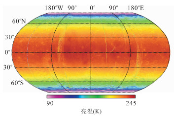
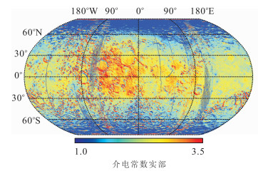
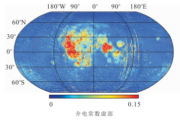
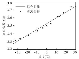
Abstract:
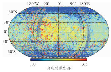
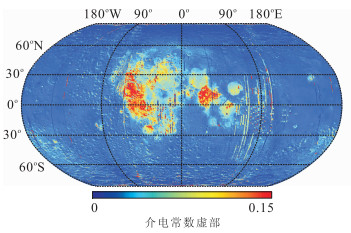
Dielectric constant of lunar soil is the basis of lunar microwave remote sensing detection and it is an indispensable parameter for information extraction of lunar regolith layer thickness and composition. With the aim to simulate dielectric constant for the whole moon, the correction of time angle on brightness temperature data captured by microwave radiometer on board of Chang'E-2 is carried out in the paper and the distribution map of the whole lunar surface microwave brightness temperature under the same time angle with various lunar terrains is obtained, soil compositions and latitudes is obtained. By applying the radiative transfer model to the corrected microwave temperature brightness, the distribution of dielectric constants for 3GHz channel in the whole moon is obtained. The real part of dielectric constant in the lunar mare region is higher than that in highland and this value is low in polar region. The imaginary part in lunar mare and Aitken basin are relatively higher. The dielectric constant data have been calibrated in the experiment to obtain dielectric constant temperature at 22℃. To compare the electric constant of real lunar soil samplings under normal temperature on Earth with inversed results, the results show as follows: the relative error of the real part of dielectric constant is less than 11%; the relative error of the imaginary part of dielectric constant is higher, but the maximum difference is below 0.02. So it is feasible to derive the dielectric constant inversion in the manner of utilizing brightness temperature data of microwave radiometer on board of Chang'E-2.
Dielectric constant of lunar soil is the basis of lunar microwave remote sensing detection and it is an indispensable parameter for information extraction of lunar regolith layer thickness and composition. With the aim to simulate dielectric constant for the whole moon, the correction of time angle on brightness temperature data captured by microwave radiometer on board of Chang'E-2 is carried out in the paper and the distribution map of the whole lunar surface microwave brightness temperature under the same time angle with various lunar terrains is obtained, soil compositions and latitudes is obtained. By applying the radiative transfer model to the corrected microwave temperature brightness, the distribution of dielectric constants for 3GHz channel in the whole moon is obtained. The real part of dielectric constant in the lunar mare region is higher than that in highland and this value is low in polar region. The imaginary part in lunar mare and Aitken basin are relatively higher. The dielectric constant data have been calibrated in the experiment to obtain dielectric constant temperature at 22℃. To compare the electric constant of real lunar soil samplings under normal temperature on Earth with inversed results, the results show as follows: the relative error of the real part of dielectric constant is less than 11%; the relative error of the imaginary part of dielectric constant is higher, but the maximum difference is below 0.02. So it is feasible to derive the dielectric constant inversion in the manner of utilizing brightness temperature data of microwave radiometer on board of Chang'E-2.