2024 Vol. 49, No. 9
Display Method:
2024, 49(9): 3071-3088.
doi: 10.3799/dqkx.2023.086
 PDF 30499KB
Abstract:
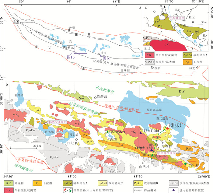
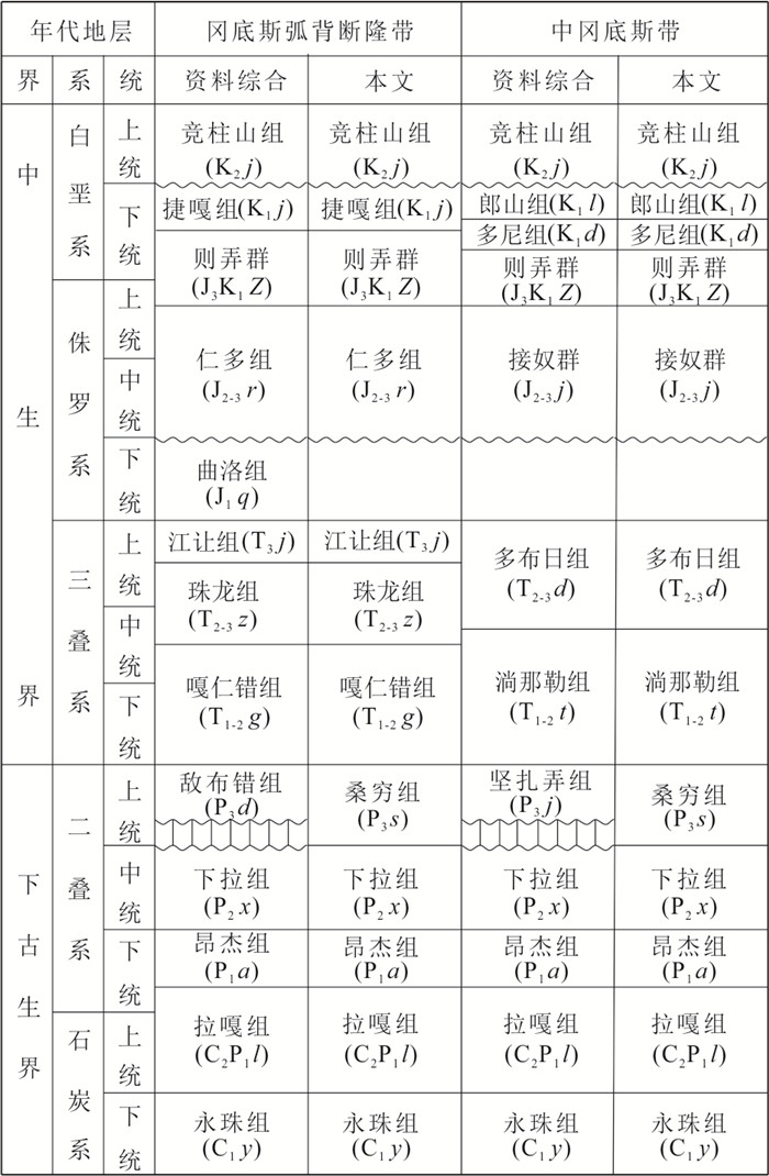
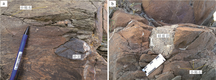
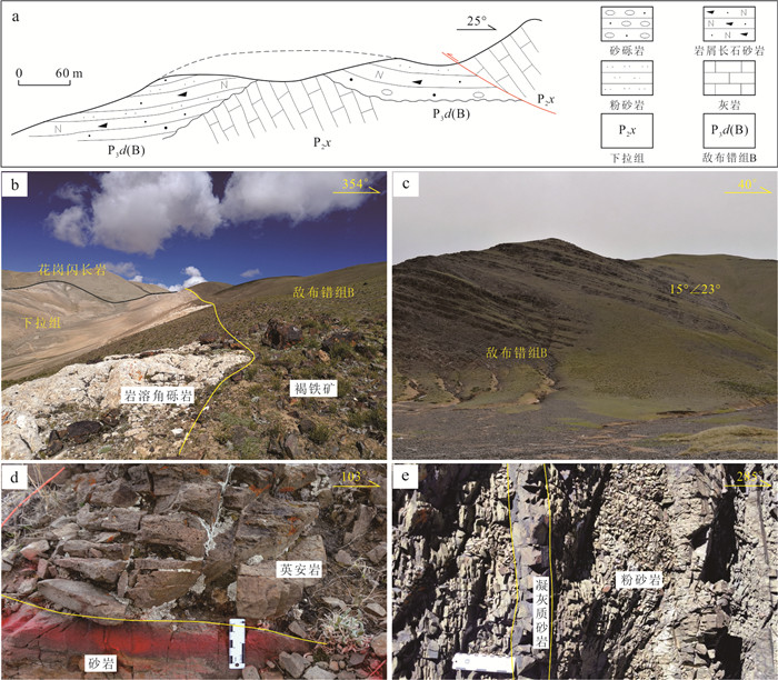
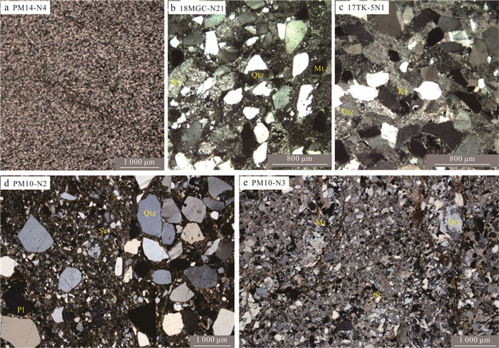
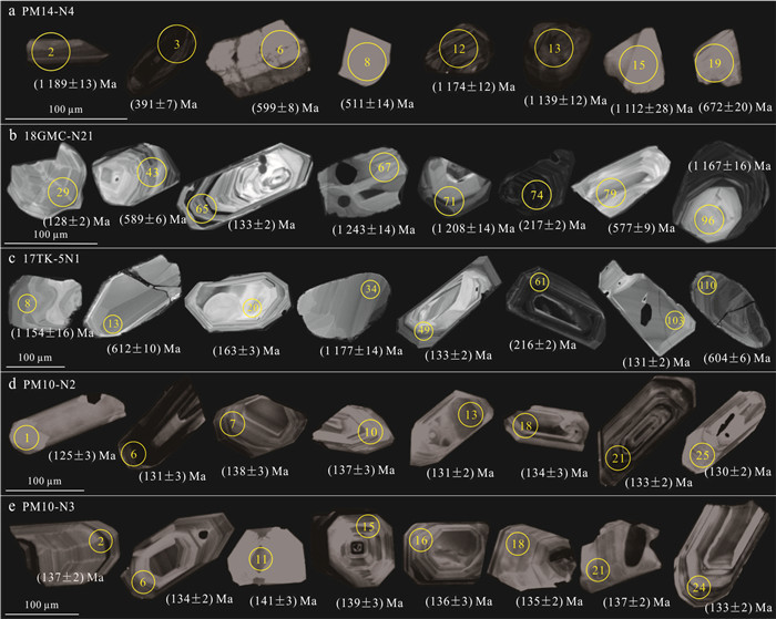
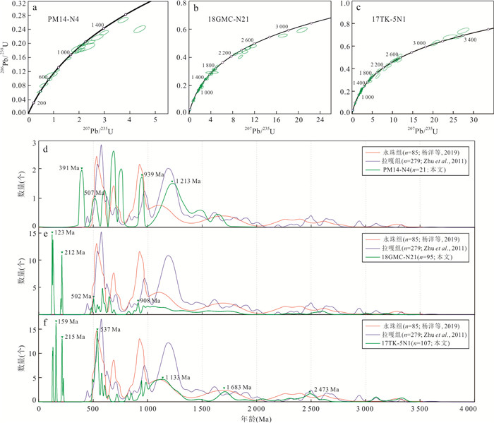
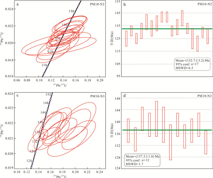
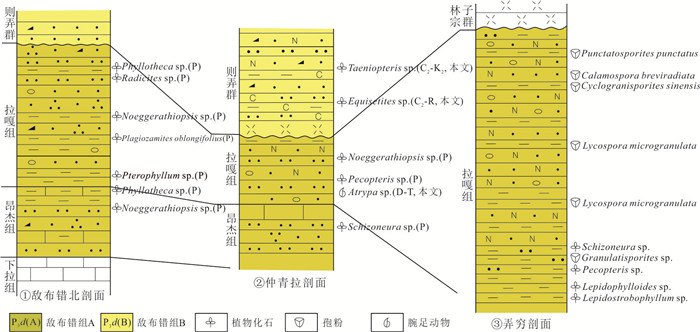
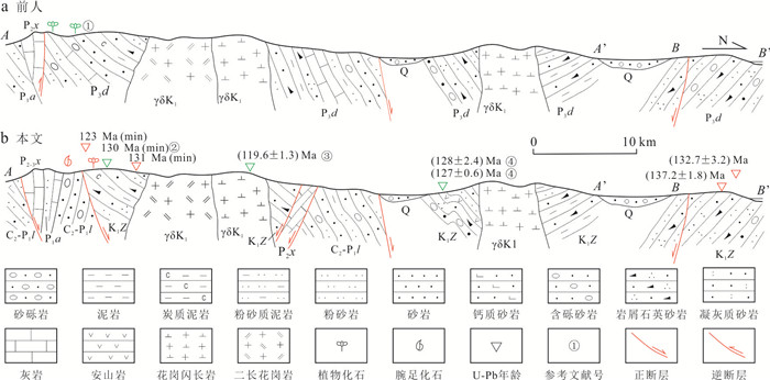
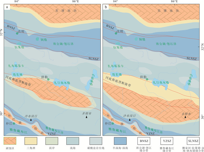
The Upper Permian Dibucuo Formation in Cuoqin area is subject to age redetermination to accurately understand its geological significance since it is contradicted by the research progress of regional paleontology and stratigraphy. Based on field survey, regional stratigraphic correlation and detrital zircons U-Pb dating, the Dibucuo Formation is reclassified into three lithostratigraphic units of different ages. The Dibucuo Formation A is characterized by conglomerate-bearing sand-slate and Late Paleozoic plant fossils, and similar clastic zircons age spectrum with the Laga Formation, which should be classified into Laga Formation or Angjie Formation. Dibucuo Formation B is mainly composed of marine-continental clastic rocks, which is determined as the lower part of the Lower Cretaceous Zenong Group according to the Early Cretaceous clastic zircons and its emplacement by Early Cretaceous intrusive rocks. Dibucuo Formation C is almost completely composed of the late Early Cretaceous volcanic and pyroclastic rocks, consistent with the upper part of the Lower Cretaceous Zenong Group. Combined with the regional data, it is believed that the Cuoqin area was a continuous carbonate deposit from the Middle Permian to the Late Triassic, which was not affected by the Late Paleozoic Gangdese island arc orogenesis. The Early Cretaceous southern boundary of Bangongco-Nujiang residual sea basin in Cuoqin area is pushed about 50 km southward compared with the previous understanding.
The Upper Permian Dibucuo Formation in Cuoqin area is subject to age redetermination to accurately understand its geological significance since it is contradicted by the research progress of regional paleontology and stratigraphy. Based on field survey, regional stratigraphic correlation and detrital zircons U-Pb dating, the Dibucuo Formation is reclassified into three lithostratigraphic units of different ages. The Dibucuo Formation A is characterized by conglomerate-bearing sand-slate and Late Paleozoic plant fossils, and similar clastic zircons age spectrum with the Laga Formation, which should be classified into Laga Formation or Angjie Formation. Dibucuo Formation B is mainly composed of marine-continental clastic rocks, which is determined as the lower part of the Lower Cretaceous Zenong Group according to the Early Cretaceous clastic zircons and its emplacement by Early Cretaceous intrusive rocks. Dibucuo Formation C is almost completely composed of the late Early Cretaceous volcanic and pyroclastic rocks, consistent with the upper part of the Lower Cretaceous Zenong Group. Combined with the regional data, it is believed that the Cuoqin area was a continuous carbonate deposit from the Middle Permian to the Late Triassic, which was not affected by the Late Paleozoic Gangdese island arc orogenesis. The Early Cretaceous southern boundary of Bangongco-Nujiang residual sea basin in Cuoqin area is pushed about 50 km southward compared with the previous understanding.
2024, 49(9): 3089-3105.
doi: 10.3799/dqkx.2022.241
Abstract:
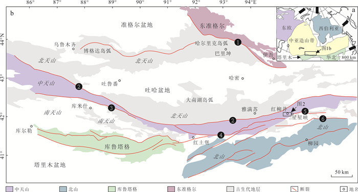
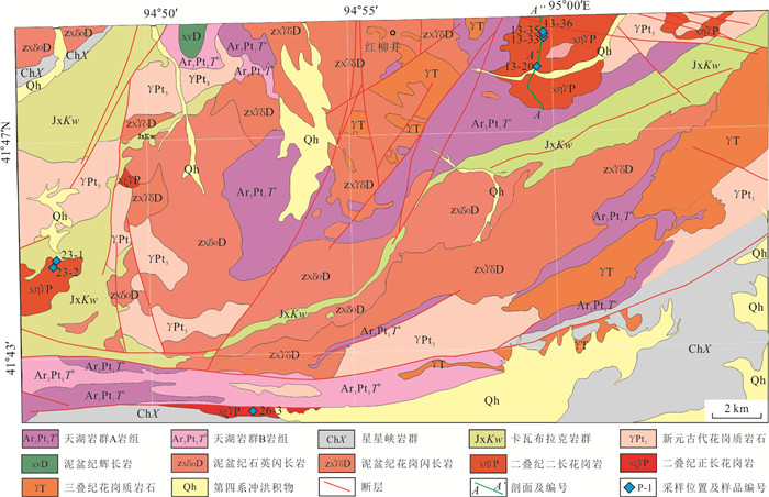
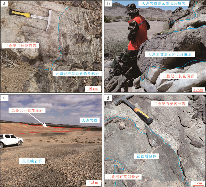
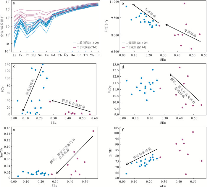
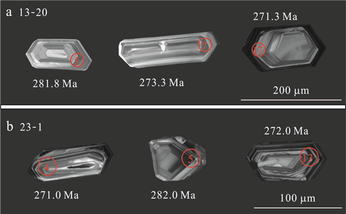
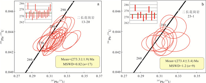
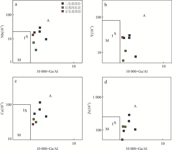
Time of terminal accretion of the Central Asian Orogenic Belt (CAOB) is still controversial, and A-type granite in the southern margin of the CAOB can provide critical constraints on the termination of collision. However, the A-type granite in the southern margin of eastern Tianshan remains insufficiently studied. Three kinds of newly identified A-type granitoids, monzogranite, quartz diorite and syenogranite, were reported in this paper and zircon LA-ICP-MS U-Pb dating, trace elements as well as petrogeochemical analysis were conducted. All these granitoids are characterized by high SiO2 (71.32%-76.35%), alkali (Na2O+K2O=5.67%-9.18%), being metaluminous (molar A/CNK=0.85-0.98) and ferroan (FeOT/MgO=5.52-21.28). The granitoids are enriched in Pb, Hf, Zr, Sm, but depleted in P, Ti, Nb, with high Ga value (18.2×10⁻⁶-31.1×10⁻⁶) and Ga/Al > 2.6. In addition, these granitoids have ΣREE of 77.67×10⁻⁶-271.82×10⁻⁶, LREE/HREE of 2.82-16.26, (La/Yb)N of 1.80-21.89. Eu anomalies are obviously positive (δEu=0.16-0.84) for both Monzogranite and syenogranite but weakly negative or positive (δEu=0.85-1.20) for the quartz diorite. Monzogranite and syenogranite rather than quartz diorite experienced obvious crystalline fractionation of plagioclase. Monzogranite associated with syenogranite and quartz diorite was also subjected to fractional crystalization of zircon, while the independent one experienced separation of sphene and apatite. Zircon U-Pb dating of monzogranite yields crystallization ages of (273.3±1.9) Ma and (273.4±3.4) Ma. These geochemical features indicate that the primary magma of these A-type granitoids most likely originated from the Xingxingxia complex with minor mantle component, and underwent a fractional crystallization. There exist two distinguished ranges of 307-284 Ma and 273 Ma for A-type granitoids in the Tianshan Orogen, and the elder formed in partial extension environment during the compression period while the younger were emplaced in post-collision background. The eastern section of the southern CAOB had been in post-collision environment in ~273 Ma, and final collision between the eastern section of CAOB and the Tarim Plate should be earlier than 273 Ma.
Time of terminal accretion of the Central Asian Orogenic Belt (CAOB) is still controversial, and A-type granite in the southern margin of the CAOB can provide critical constraints on the termination of collision. However, the A-type granite in the southern margin of eastern Tianshan remains insufficiently studied. Three kinds of newly identified A-type granitoids, monzogranite, quartz diorite and syenogranite, were reported in this paper and zircon LA-ICP-MS U-Pb dating, trace elements as well as petrogeochemical analysis were conducted. All these granitoids are characterized by high SiO2 (71.32%-76.35%), alkali (Na2O+K2O=5.67%-9.18%), being metaluminous (molar A/CNK=0.85-0.98) and ferroan (FeOT/MgO=5.52-21.28). The granitoids are enriched in Pb, Hf, Zr, Sm, but depleted in P, Ti, Nb, with high Ga value (18.2×10⁻⁶-31.1×10⁻⁶) and Ga/Al > 2.6. In addition, these granitoids have ΣREE of 77.67×10⁻⁶-271.82×10⁻⁶, LREE/HREE of 2.82-16.26, (La/Yb)N of 1.80-21.89. Eu anomalies are obviously positive (δEu=0.16-0.84) for both Monzogranite and syenogranite but weakly negative or positive (δEu=0.85-1.20) for the quartz diorite. Monzogranite and syenogranite rather than quartz diorite experienced obvious crystalline fractionation of plagioclase. Monzogranite associated with syenogranite and quartz diorite was also subjected to fractional crystalization of zircon, while the independent one experienced separation of sphene and apatite. Zircon U-Pb dating of monzogranite yields crystallization ages of (273.3±1.9) Ma and (273.4±3.4) Ma. These geochemical features indicate that the primary magma of these A-type granitoids most likely originated from the Xingxingxia complex with minor mantle component, and underwent a fractional crystallization. There exist two distinguished ranges of 307-284 Ma and 273 Ma for A-type granitoids in the Tianshan Orogen, and the elder formed in partial extension environment during the compression period while the younger were emplaced in post-collision background. The eastern section of the southern CAOB had been in post-collision environment in ~273 Ma, and final collision between the eastern section of CAOB and the Tarim Plate should be earlier than 273 Ma.
2024, 49(9): 3106-3121.
doi: 10.3799/dqkx.2023.097
Abstract:
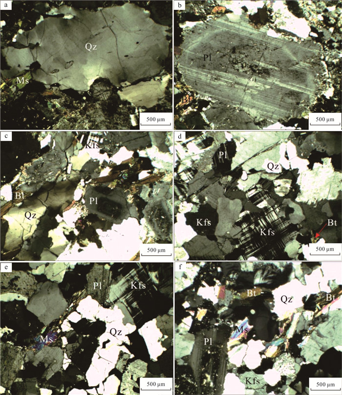
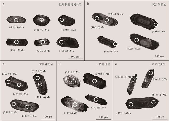
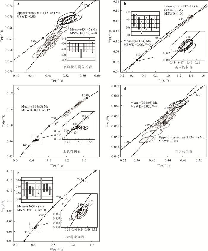
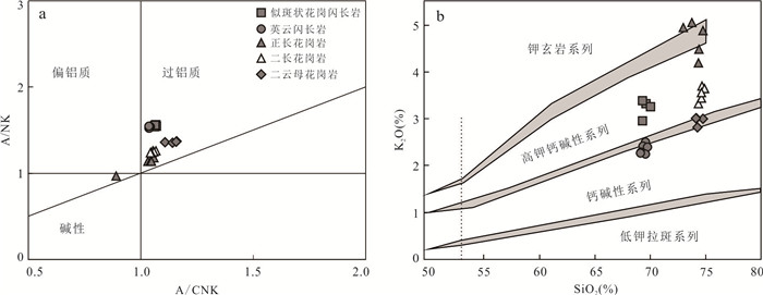
Magmatism plays an important role in rebuilding evolutionary history of orogenic belts. This paper presents a systematic study of petrology, geochemistry and geochronology on the Lüliangshan granite pluton at west segment of the North Qaidam ultrahigh pressure metamorphic belt. The results show that the Lüliangshan pluton is a composite granite pluton formed in three magma periods in response to continental crust subduction, exhumation and mountain collapse. The first period (436-430 Ma) formed mainly small scale porphyry granodiorite, which is partial melting products of thickened mafic lower crust during continental subduction. The second period (400-390 Ma) formed tonalite and minor synogranite and monzonitic granite, which are partial melting products of exhumed eclogite-bearing ultrahigh pressure metamorphic terrane and lower continental crust during post-collisional extension. The third period (365-360 Ma) formed large scale two-mica granite, with strong peraluminous S-type granite geochemical characteristics and is partial melting products of metapelite during orogen unrooting and collapse.
Magmatism plays an important role in rebuilding evolutionary history of orogenic belts. This paper presents a systematic study of petrology, geochemistry and geochronology on the Lüliangshan granite pluton at west segment of the North Qaidam ultrahigh pressure metamorphic belt. The results show that the Lüliangshan pluton is a composite granite pluton formed in three magma periods in response to continental crust subduction, exhumation and mountain collapse. The first period (436-430 Ma) formed mainly small scale porphyry granodiorite, which is partial melting products of thickened mafic lower crust during continental subduction. The second period (400-390 Ma) formed tonalite and minor synogranite and monzonitic granite, which are partial melting products of exhumed eclogite-bearing ultrahigh pressure metamorphic terrane and lower continental crust during post-collisional extension. The third period (365-360 Ma) formed large scale two-mica granite, with strong peraluminous S-type granite geochemical characteristics and is partial melting products of metapelite during orogen unrooting and collapse.
2024, 49(9): 3122-3139.
doi: 10.3799/dqkx.2023.095
Abstract:
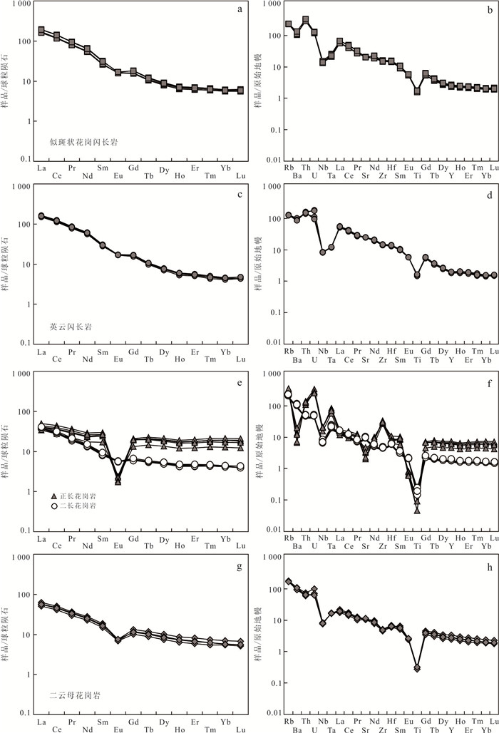
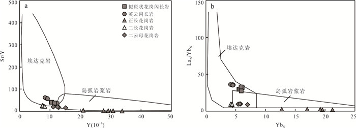
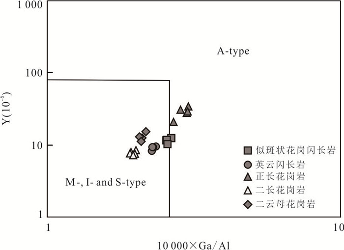
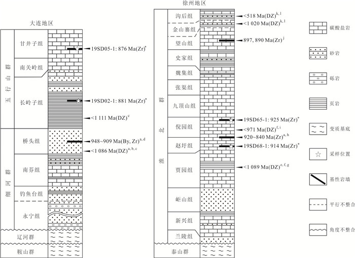
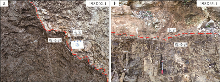
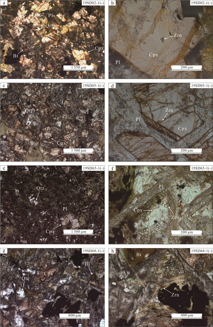
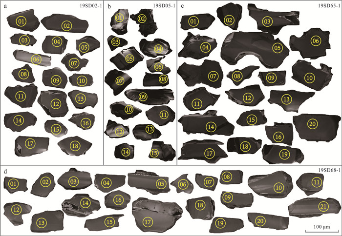
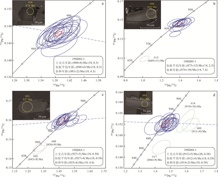
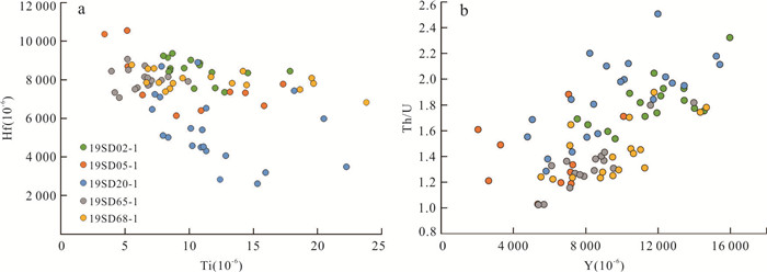
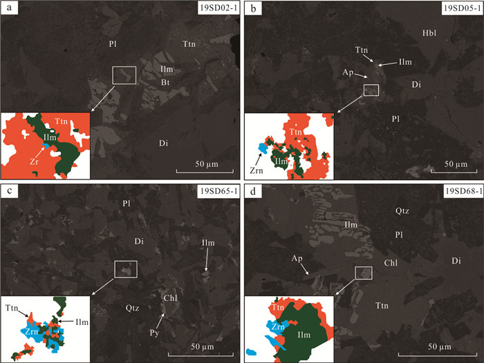
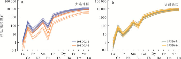
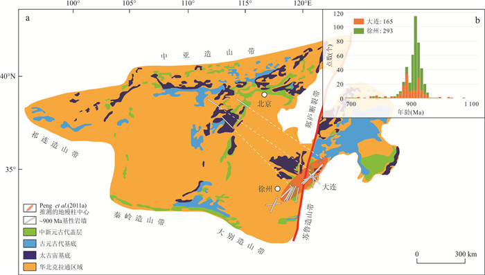
The tectonic setting of the Neoproterozoic mafic sills (dykes) in the eastern margin of the North China Craton is of great significance for reconstructing the position of the Craton in Rodinia supercontinent. By analyzing the structure, paragenetic relationship with other minerals, and trace element characteristics of zircons in four mafic rock sill samples from Dalian and Xuzhou regions, it is found that they have typical structural and trace element characteristics of mafic magmatic zircons. Most of the crystallization temperatures (about 800-900 ℃) are consistent with those of zircons in mid-ocean ridge basalts, and some zircons can be observed to appear in clinopyroxene as inclusions. The above characteristics indicate that these zircons were formed in the early stage of cooling crystallization of mafic magma. Their U-Pb ages (881 Ma, 876 Ma, 914 Ma, and 925 Ma) can represent the emplacement age of mafic sills, and their trace elements show the characteristics of continental island arc magmatic zircons. Based on the geometric distribution of mafic sills (dykes) and the duration of magmatic activity, we suggest that they may have formed in a subduction related tensile environment.
The tectonic setting of the Neoproterozoic mafic sills (dykes) in the eastern margin of the North China Craton is of great significance for reconstructing the position of the Craton in Rodinia supercontinent. By analyzing the structure, paragenetic relationship with other minerals, and trace element characteristics of zircons in four mafic rock sill samples from Dalian and Xuzhou regions, it is found that they have typical structural and trace element characteristics of mafic magmatic zircons. Most of the crystallization temperatures (about 800-900 ℃) are consistent with those of zircons in mid-ocean ridge basalts, and some zircons can be observed to appear in clinopyroxene as inclusions. The above characteristics indicate that these zircons were formed in the early stage of cooling crystallization of mafic magma. Their U-Pb ages (881 Ma, 876 Ma, 914 Ma, and 925 Ma) can represent the emplacement age of mafic sills, and their trace elements show the characteristics of continental island arc magmatic zircons. Based on the geometric distribution of mafic sills (dykes) and the duration of magmatic activity, we suggest that they may have formed in a subduction related tensile environment.


2024, 49(9): 3140-3154.
doi: 10.3799/dqkx.2023.120
Abstract:
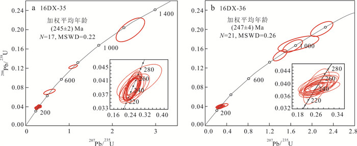
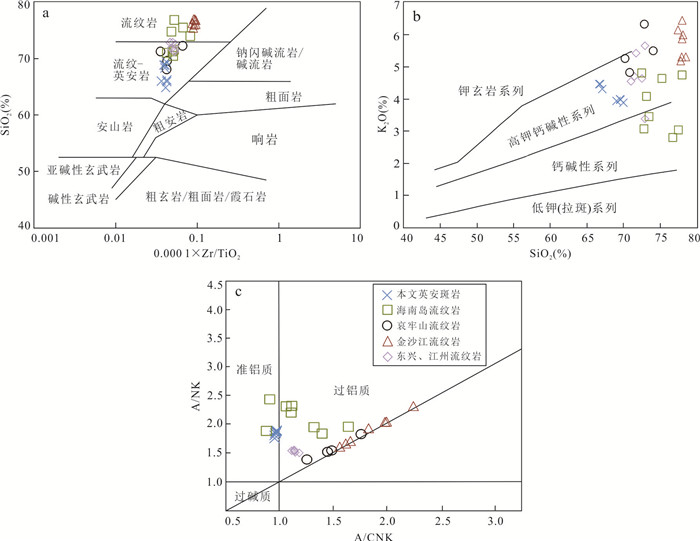
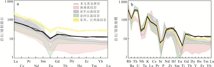
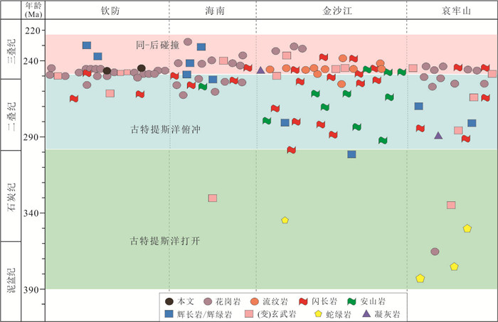
To determine the availability of the magmatism records of Palaeo-Tethyan evolution in the southeastern margin of the South China continent, detailed LA-ICP-MS zircon U-Pb geochronological and elemental geochemical analyses of the Indosinian volcanic rocks in the southeastern Guangxi have been carried out in this paper. Geochronological results show that two representative dacite porphyry samples yield zircon U-Pb ages of (245±2) Ma and (247±4) Ma, respectively, indicating that Early to Middle Triassic volcanism occurred in the southeastern Guangxi. Elemental geochemical results show that the dacite porphyry is characterized by high K2O and Al2O3 contents, and low TiO2 and MgO contents, belonging to the metaluminous high-K calc-alkaline series rocks. The samples show enrichment in Rb, Th, and U, and are characterized by negative Ba, Ti, Sr, P, and Nb-Ta anomalies. They also show obvious LREE and HREE fractionation, and have moderate negative Eu anomalies. The above data indicate that the dacite porphyry mainly originated from the melting of crustal materials, and fractional crystallization occurred during the process of magmatic evolution. Combined with regional geological data, it is suggested that the Indosinian magmatic rock assemblages, geochemical characteristics, sedimentary sequences, and paleontological fossils in the southeastern Guangxi are comparable to those in the Hainan Island and Jinshajiang-Ailaoshan regions, suggesting that these regions may have experienced similar tectonic events during the Indosinian Period, which were mainly controlled by the Palaeo-Tethyan tectonic domain during the Indosinian. The formation of the Indosinian dacite porphyry in southeastern Guangxi possibly represents a syn-collisional stage during the Early to Middle Triassic.
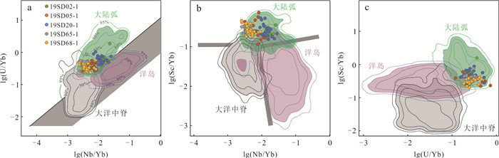
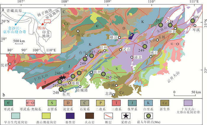
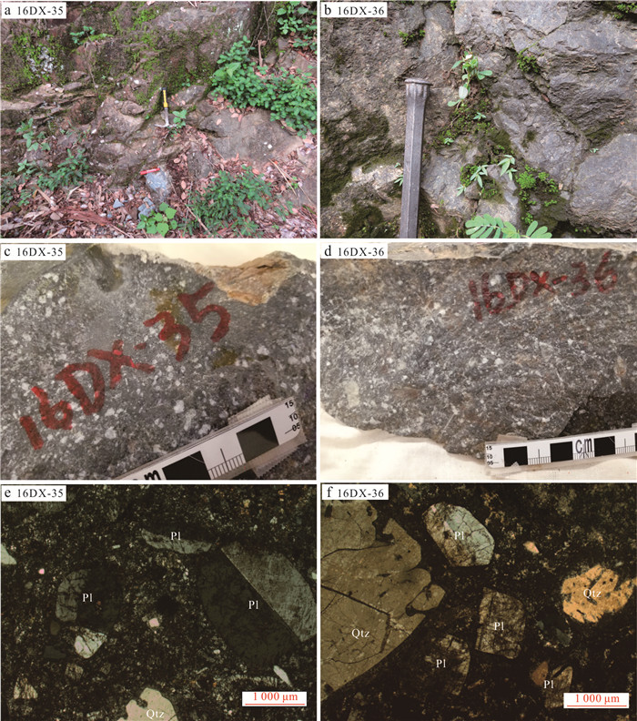
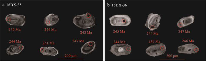
To determine the availability of the magmatism records of Palaeo-Tethyan evolution in the southeastern margin of the South China continent, detailed LA-ICP-MS zircon U-Pb geochronological and elemental geochemical analyses of the Indosinian volcanic rocks in the southeastern Guangxi have been carried out in this paper. Geochronological results show that two representative dacite porphyry samples yield zircon U-Pb ages of (245±2) Ma and (247±4) Ma, respectively, indicating that Early to Middle Triassic volcanism occurred in the southeastern Guangxi. Elemental geochemical results show that the dacite porphyry is characterized by high K2O and Al2O3 contents, and low TiO2 and MgO contents, belonging to the metaluminous high-K calc-alkaline series rocks. The samples show enrichment in Rb, Th, and U, and are characterized by negative Ba, Ti, Sr, P, and Nb-Ta anomalies. They also show obvious LREE and HREE fractionation, and have moderate negative Eu anomalies. The above data indicate that the dacite porphyry mainly originated from the melting of crustal materials, and fractional crystallization occurred during the process of magmatic evolution. Combined with regional geological data, it is suggested that the Indosinian magmatic rock assemblages, geochemical characteristics, sedimentary sequences, and paleontological fossils in the southeastern Guangxi are comparable to those in the Hainan Island and Jinshajiang-Ailaoshan regions, suggesting that these regions may have experienced similar tectonic events during the Indosinian Period, which were mainly controlled by the Palaeo-Tethyan tectonic domain during the Indosinian. The formation of the Indosinian dacite porphyry in southeastern Guangxi possibly represents a syn-collisional stage during the Early to Middle Triassic.

2024, 49(9): 3155-3181.
doi: 10.3799/dqkx.2023.079
Abstract:
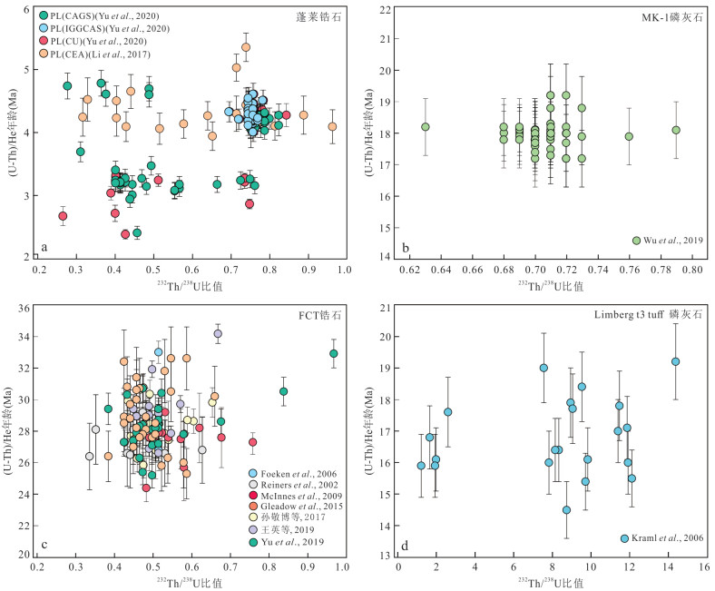
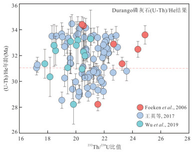
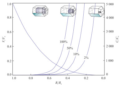
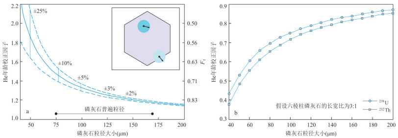
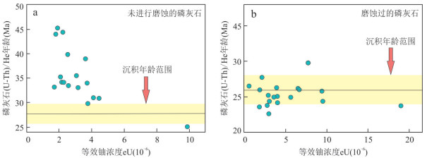
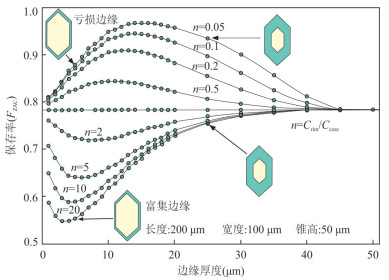
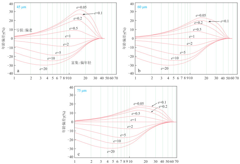
(U-Th)/He isotopic dating with its low-temperature sensitivity (70 ℃), provides an accurate time-temperature evolution model for the construction of temporal-spatial framework of uplift and denudation rates in orogenic belts, temporal constraints on hydrocarbon formation, recovery of burial history in sedimentary basins, the study of denudation and preservation of mineral deposits, and reconstruction of paleotopography and geomorphology, with promising applications. Understanding mineral closure temperatures, internal structure, 4He diffusion mechanisms, and uranium-thorium zoning effects are keys to interpreting (U-Th)/He data. A detailed discussion of (U-Th)/He technical studies is presented, including the appropriate target minerals and different geological applications for dating, the development of test methods and standard references, a focus on the factors that contribute to age bias, and a brief description of the radiation damage mechanisms for the major minerals. Research has shown that China's (U-Th)/He dating technology has advanced significantly, progressing from the non-dilution method to the single-particle laser fusion technique, and subsequently to the in-situ micro-area dual dating method using the RESOlution excimer laser ablation system. Measurement results from FCT zircon, Durango apatite, and Penglai zircon align closely with international calibration ages, falling within the expected margin of error. Moreover, an MK-1 apatite standard sample has been developed independently, indicating the maturity of the technology. Most of the uranium-thorium bearing minerals that have effectively preserved 4He can be suitable objects for dating. A summary of strategies to effectively avoid the effects of mineral inclusions, mineral grain size, α-particle ejection and implantation effects, and compositional ring-banding can help Chinese scholars interpret (U-Th)/He data.
(U-Th)/He isotopic dating with its low-temperature sensitivity (70 ℃), provides an accurate time-temperature evolution model for the construction of temporal-spatial framework of uplift and denudation rates in orogenic belts, temporal constraints on hydrocarbon formation, recovery of burial history in sedimentary basins, the study of denudation and preservation of mineral deposits, and reconstruction of paleotopography and geomorphology, with promising applications. Understanding mineral closure temperatures, internal structure, 4He diffusion mechanisms, and uranium-thorium zoning effects are keys to interpreting (U-Th)/He data. A detailed discussion of (U-Th)/He technical studies is presented, including the appropriate target minerals and different geological applications for dating, the development of test methods and standard references, a focus on the factors that contribute to age bias, and a brief description of the radiation damage mechanisms for the major minerals. Research has shown that China's (U-Th)/He dating technology has advanced significantly, progressing from the non-dilution method to the single-particle laser fusion technique, and subsequently to the in-situ micro-area dual dating method using the RESOlution excimer laser ablation system. Measurement results from FCT zircon, Durango apatite, and Penglai zircon align closely with international calibration ages, falling within the expected margin of error. Moreover, an MK-1 apatite standard sample has been developed independently, indicating the maturity of the technology. Most of the uranium-thorium bearing minerals that have effectively preserved 4He can be suitable objects for dating. A summary of strategies to effectively avoid the effects of mineral inclusions, mineral grain size, α-particle ejection and implantation effects, and compositional ring-banding can help Chinese scholars interpret (U-Th)/He data.
2024, 49(9): 3182-3198.
doi: 10.3799/dqkx.2023.073
Abstract:
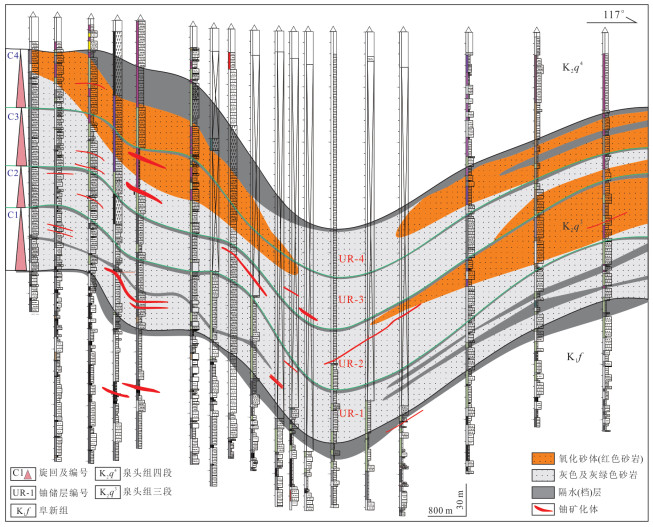
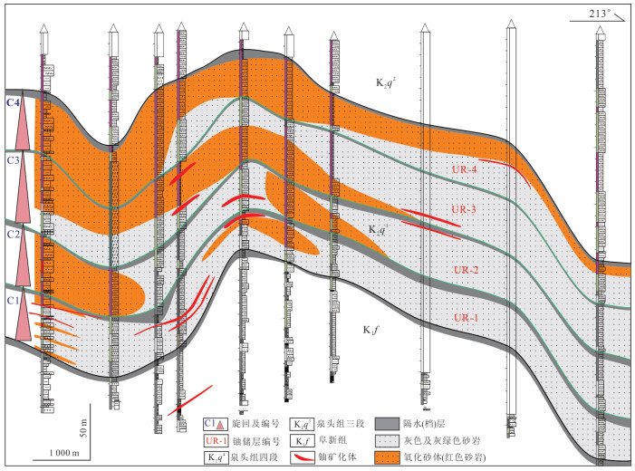
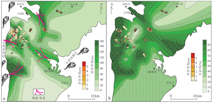
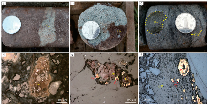
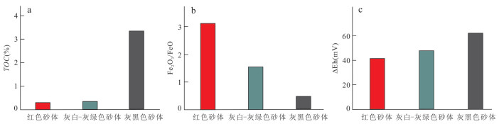
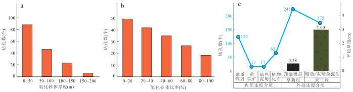
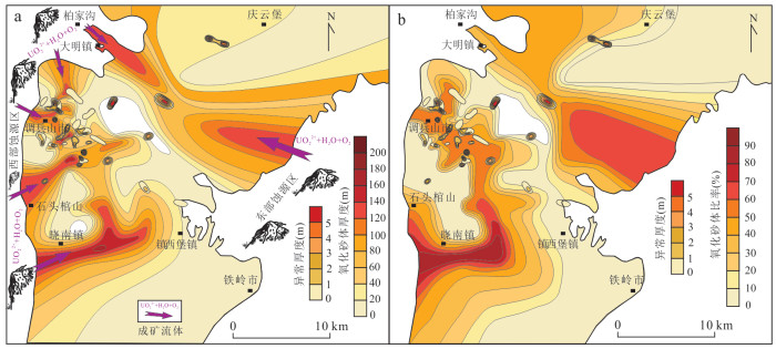
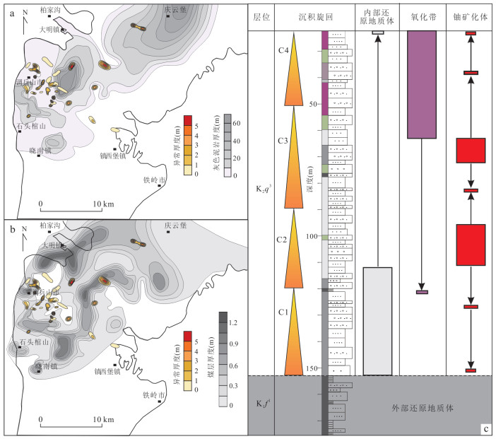
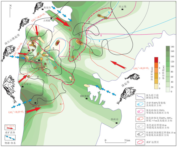
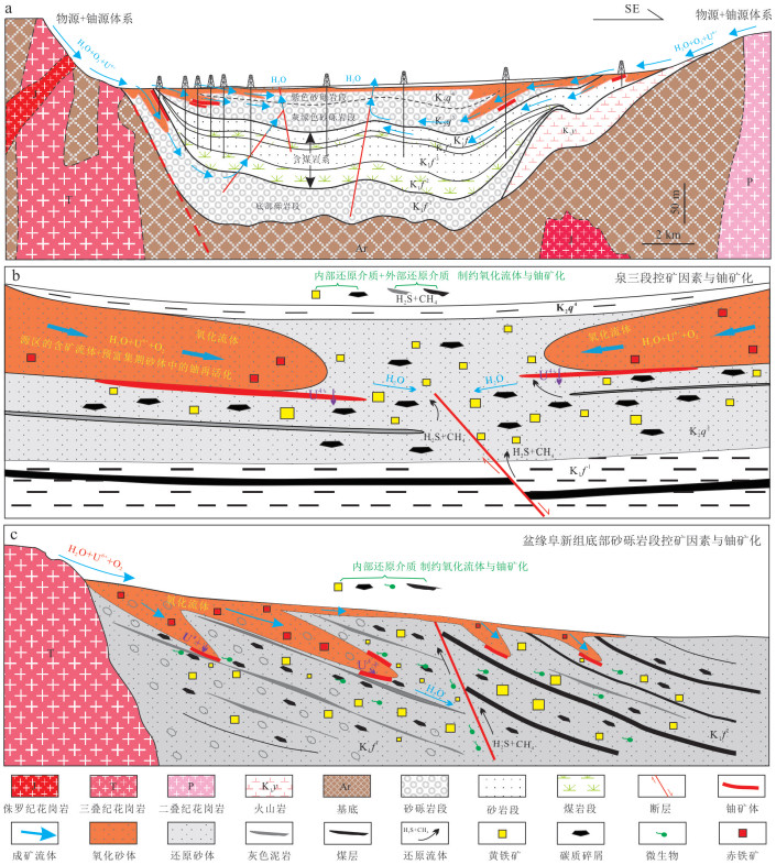
A new uranium deposit and many uranium mineralization spots have been discovered in the Cretaceous strata of the Tiefa area in the southeastern Songliao basin. Based on the regional geological background investigation and the analysis of more than 1 000 drilling data, the author conducts a quantitative and systematic study on the key ore-controlling factors, such as uranium reservoir, interlayer oxidation zone and reducing medium in the uranium metallogenic system from source to sink in the study area. The sandstone-type uranium deposits in the study area have experienced two important stages: the pre-enrichment stage in the depositional stage and the main metallogenic stage in the interlayer oxidation stage. The basin-mountain coupling driven by regional tectonic evolution not only controls the formation and migration of uranium sources, but also drives the tectonic inversion between the two metallogenic stages. The distribution law of uranium mineralization in the study area has obvious spatial coupling relationship with ore control factors such as uranium reservoir heterogeneity, oxidized sand body size, and reducing medium, etc. The gray mudstone at the bottom of the 3rd member of Quantou Formation and the coal seam at the top of the Fuxin Formation restrict the scale of the interlayer oxidation zone and the distribution of uranium mineralization. The 3rd member of Quantou Formation has developed uranium reservoir sand bodies with a complete "mud-sand-mud" structure and obvious clues of uranium mineralization. It is the most favorable layer for sandstone-type uranium mineralization in this area, followed by the glutenite at the bottom of the Fuxin Formation in the western margin of the depression. The most favorable parts for sandstone-type uranium mineralization is in the west of the depression, where the sandstone body of uranium reservoir in the 3rd member of Quantou Formation has changed from thick to thin, the sand content has changed from high to low, the ratio of the thickness to the oxidized sand body decreased, and the external reducing geological bodies such as gray mudstone and coal seams have changed from thin to thick.
A new uranium deposit and many uranium mineralization spots have been discovered in the Cretaceous strata of the Tiefa area in the southeastern Songliao basin. Based on the regional geological background investigation and the analysis of more than 1 000 drilling data, the author conducts a quantitative and systematic study on the key ore-controlling factors, such as uranium reservoir, interlayer oxidation zone and reducing medium in the uranium metallogenic system from source to sink in the study area. The sandstone-type uranium deposits in the study area have experienced two important stages: the pre-enrichment stage in the depositional stage and the main metallogenic stage in the interlayer oxidation stage. The basin-mountain coupling driven by regional tectonic evolution not only controls the formation and migration of uranium sources, but also drives the tectonic inversion between the two metallogenic stages. The distribution law of uranium mineralization in the study area has obvious spatial coupling relationship with ore control factors such as uranium reservoir heterogeneity, oxidized sand body size, and reducing medium, etc. The gray mudstone at the bottom of the 3rd member of Quantou Formation and the coal seam at the top of the Fuxin Formation restrict the scale of the interlayer oxidation zone and the distribution of uranium mineralization. The 3rd member of Quantou Formation has developed uranium reservoir sand bodies with a complete "mud-sand-mud" structure and obvious clues of uranium mineralization. It is the most favorable layer for sandstone-type uranium mineralization in this area, followed by the glutenite at the bottom of the Fuxin Formation in the western margin of the depression. The most favorable parts for sandstone-type uranium mineralization is in the west of the depression, where the sandstone body of uranium reservoir in the 3rd member of Quantou Formation has changed from thick to thin, the sand content has changed from high to low, the ratio of the thickness to the oxidized sand body decreased, and the external reducing geological bodies such as gray mudstone and coal seams have changed from thin to thick.
2024, 49(9): 3199-3211.
doi: 10.3799/dqkx.2023.115
Abstract:
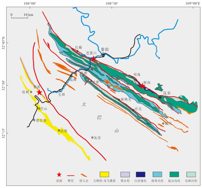
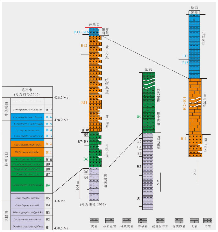
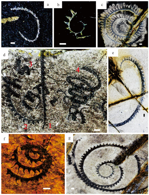
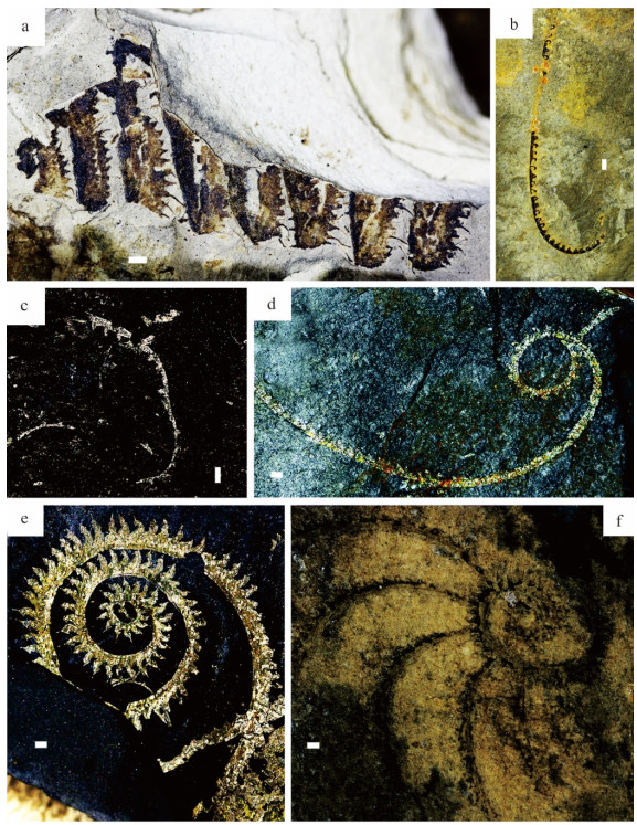
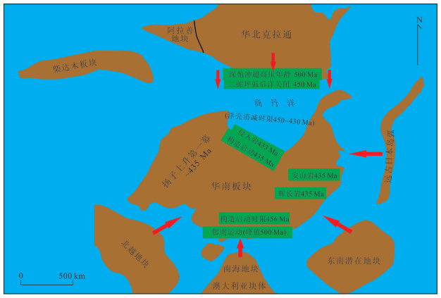
There is still much debate on whether the Kwangsian Orogeny involved in the northern margin of the South China Block, which consequently restricts our understanding of the tectonic dynamics.In this research, the biostratigraphic and petrological evidence from the North Daba Mountains indicates that the tectonic-sedimentary marks the Kwangsian Orogeny in the north margin of the South China Block. Here, the Kwangsian initiated at Spirograptus turriculatus Biozone (Telychian stage, Silurian), consistent with the first episode of the "Yangtze uplift" (~435 Ma), and it reached the peak of the tectonic activity for the first time at Oktavites spiralis⁃Cyrtograptus lapworthi Biozone (Telychian stage, Silurian) accompanied with the ~433 Ma intensive magmatism.This study further expands the tectonic scope of the Kwangsian Orogeny to the north margin of the South China Block, providing important new insights into the tectonic model and dynamics.It is suggested that the distant effects of the collision between the North China Block and South China Block may be one of the important tectonic driving force of the Kwangsian Orogeny.
There is still much debate on whether the Kwangsian Orogeny involved in the northern margin of the South China Block, which consequently restricts our understanding of the tectonic dynamics.In this research, the biostratigraphic and petrological evidence from the North Daba Mountains indicates that the tectonic-sedimentary marks the Kwangsian Orogeny in the north margin of the South China Block. Here, the Kwangsian initiated at Spirograptus turriculatus Biozone (Telychian stage, Silurian), consistent with the first episode of the "Yangtze uplift" (~435 Ma), and it reached the peak of the tectonic activity for the first time at Oktavites spiralis⁃Cyrtograptus lapworthi Biozone (Telychian stage, Silurian) accompanied with the ~433 Ma intensive magmatism.This study further expands the tectonic scope of the Kwangsian Orogeny to the north margin of the South China Block, providing important new insights into the tectonic model and dynamics.It is suggested that the distant effects of the collision between the North China Block and South China Block may be one of the important tectonic driving force of the Kwangsian Orogeny.
2024, 49(9): 3212-3227.
doi: 10.3799/dqkx.2023.116
Abstract:
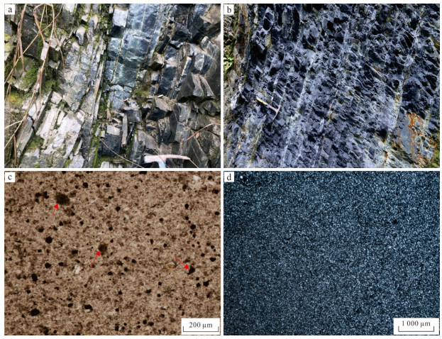
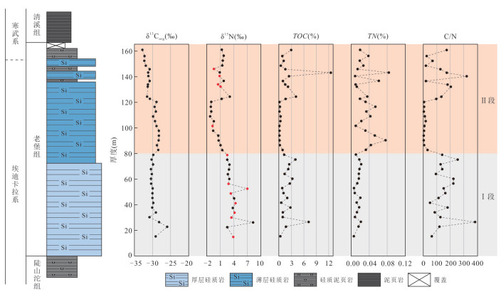
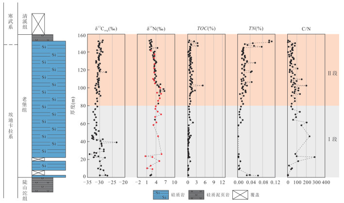
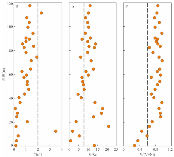
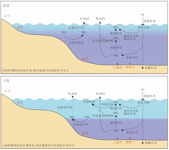
The reconstruction of the paleo-ocean nitrogen cycle in geological history is helpful to understanding the REDOX state of the ocean at that time, whereas the study of the Late Ediacaran marine nitrogen cycle is relatively insufficient. Here we report detailed nitrogen isotope (δ15N) and organic carbon isotopic compositions (δ13Corg) from the Silikou section in northern Guangxi and the Shangdiping section in southeastern Guizhou Province. The results show that the average values of δ15N from the Silikou section and Shangdiping section are (1.6±2.0)‰ and (3.5±1.1)‰, respectively, both of which show a gradual decrease from old to new. The mean δ13Corg values of the two sections are (-30.0±1.4)‰ and (-30.6±1.4)‰, respectively. The relatively high δ15N values indicate that there was an aerobic nitrogen cycle coupled with nitrification and denitrification, and there was a stable marine nitrate reservoir in the Late Ediacaran. The gradual decrease from old to new in δ15N may result from the expansion of deep water anoxia in which denitrification and anammox can consume a large amount of NO3‒ and stimulate nitrogen fixation. Thus, the expansion of deep anoxic water column at the end of the Ediacaran may have exacerbated the extinction of the Ediacaran biota at ~542 Ma.
The reconstruction of the paleo-ocean nitrogen cycle in geological history is helpful to understanding the REDOX state of the ocean at that time, whereas the study of the Late Ediacaran marine nitrogen cycle is relatively insufficient. Here we report detailed nitrogen isotope (δ15N) and organic carbon isotopic compositions (δ13Corg) from the Silikou section in northern Guangxi and the Shangdiping section in southeastern Guizhou Province. The results show that the average values of δ15N from the Silikou section and Shangdiping section are (1.6±2.0)‰ and (3.5±1.1)‰, respectively, both of which show a gradual decrease from old to new. The mean δ13Corg values of the two sections are (-30.0±1.4)‰ and (-30.6±1.4)‰, respectively. The relatively high δ15N values indicate that there was an aerobic nitrogen cycle coupled with nitrification and denitrification, and there was a stable marine nitrate reservoir in the Late Ediacaran. The gradual decrease from old to new in δ15N may result from the expansion of deep water anoxia in which denitrification and anammox can consume a large amount of NO3‒ and stimulate nitrogen fixation. Thus, the expansion of deep anoxic water column at the end of the Ediacaran may have exacerbated the extinction of the Ediacaran biota at ~542 Ma.
2024, 49(9): 3228-3240.
doi: 10.3799/dqkx.2023.082
Abstract:
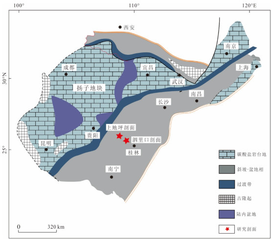
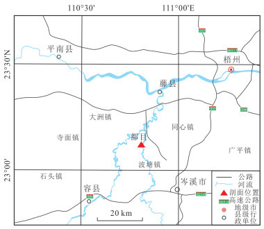
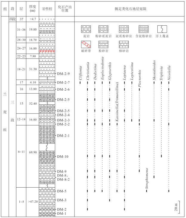
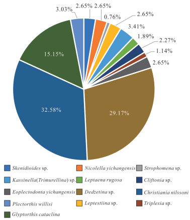
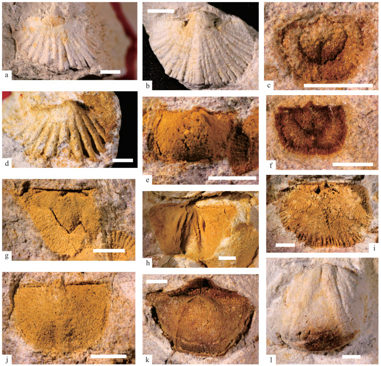
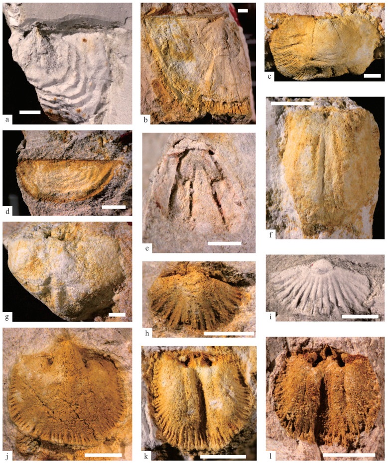
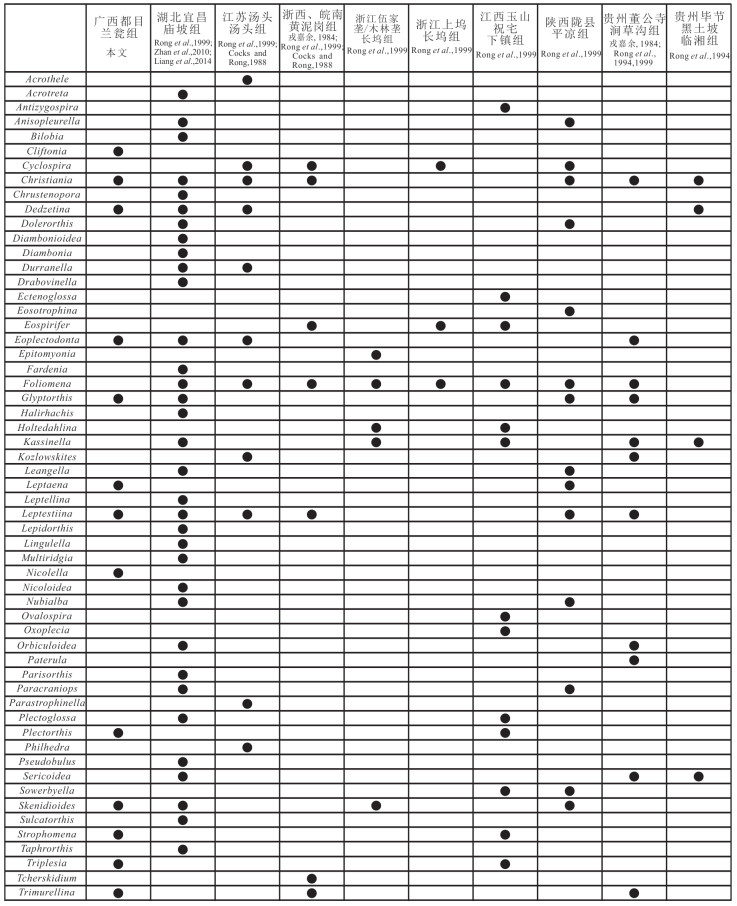
South China has recorded multiple significant geological events related to the assembly and breakup of supercontinents from the Neoproterozoic to the Early Paleozoic. However, the Cathaysia Block, one of the two major blocks constituting South China, still faces unresolved issues in the basic stratigraphic sequencing and correlation, resulting in considerable controversy regarding its tectonic attributes and its relationship with supercontinent cycles. Therefore, the marine fossils, which serve as the most direct geological evidence for stratigraphic division and correlation, is of exceptional importance in the Cathaysia Block. This paper reports the brachiopod fossils from the third member of Upper Ordovician Lanweng Formation in Cenxi area, Guangxi, of which 13 genera and 13 species have been identified. Christiania and Dedzetina are the dominant genera. The fauna generally shows the characteristics of small size, thin shell, high abundance and moderate diversity, and is dominated by Strophomenida and Orthotetida, which is similar to the atypical Foliomena fauna in the region. The fossils are produced in mudstone and silty mudstone. It is speculated that the fauna inhabits in relatively deep water environment, corresponding to BA4. The regional comparison of brachiopods confirms that the age of the occurrence horizon is the Middle-Late Katian of Late Ordovician. This fauna provides paleontological evidence for the division and correlation of the Upper Ordovician in the study area and the paleogeographic reconstruction of the South China Paleoplate.
South China has recorded multiple significant geological events related to the assembly and breakup of supercontinents from the Neoproterozoic to the Early Paleozoic. However, the Cathaysia Block, one of the two major blocks constituting South China, still faces unresolved issues in the basic stratigraphic sequencing and correlation, resulting in considerable controversy regarding its tectonic attributes and its relationship with supercontinent cycles. Therefore, the marine fossils, which serve as the most direct geological evidence for stratigraphic division and correlation, is of exceptional importance in the Cathaysia Block. This paper reports the brachiopod fossils from the third member of Upper Ordovician Lanweng Formation in Cenxi area, Guangxi, of which 13 genera and 13 species have been identified. Christiania and Dedzetina are the dominant genera. The fauna generally shows the characteristics of small size, thin shell, high abundance and moderate diversity, and is dominated by Strophomenida and Orthotetida, which is similar to the atypical Foliomena fauna in the region. The fossils are produced in mudstone and silty mudstone. It is speculated that the fauna inhabits in relatively deep water environment, corresponding to BA4. The regional comparison of brachiopods confirms that the age of the occurrence horizon is the Middle-Late Katian of Late Ordovician. This fauna provides paleontological evidence for the division and correlation of the Upper Ordovician in the study area and the paleogeographic reconstruction of the South China Paleoplate.
2024, 49(9): 3241-3251.
doi: 10.3799/dqkx.2023.112
Abstract:
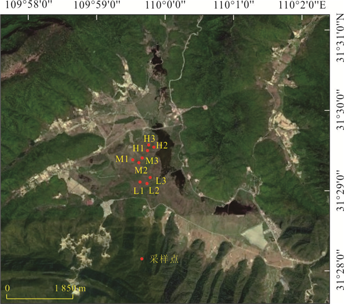
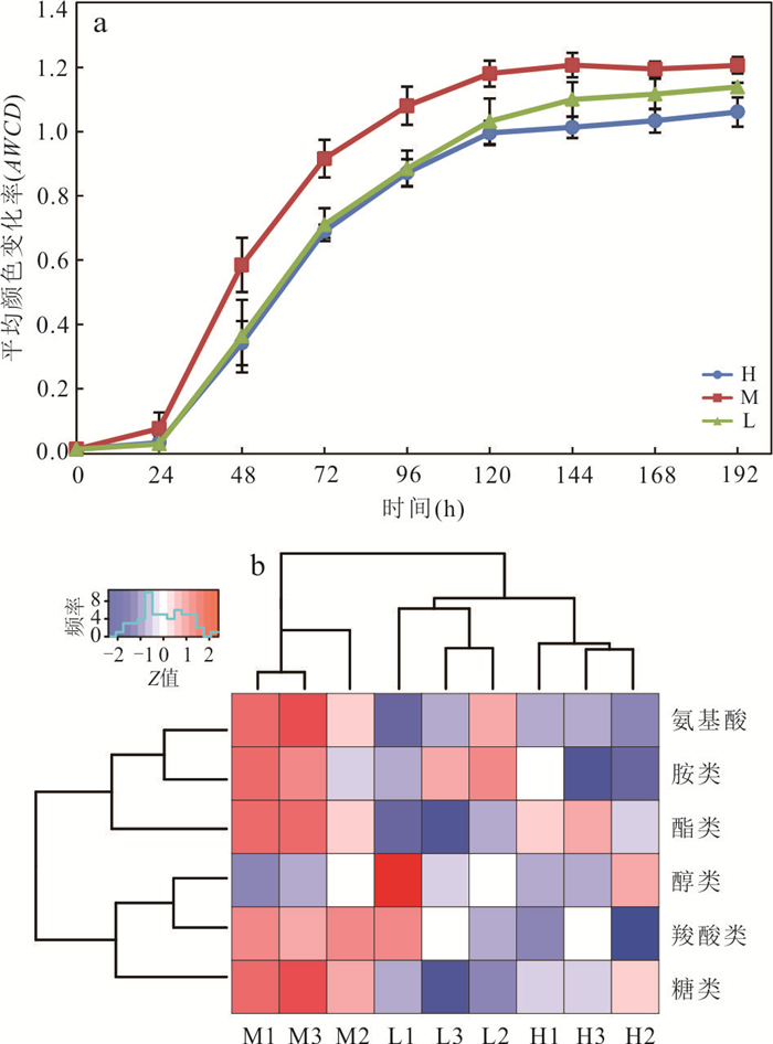
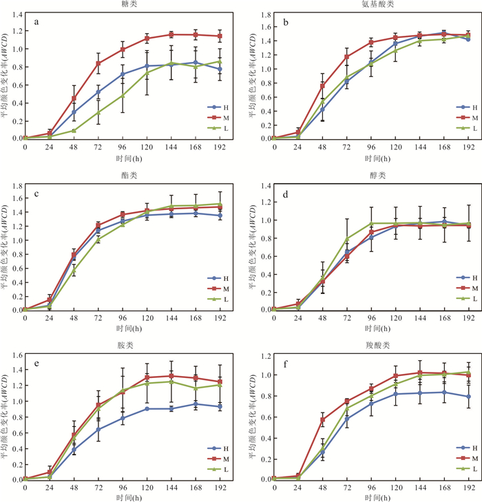
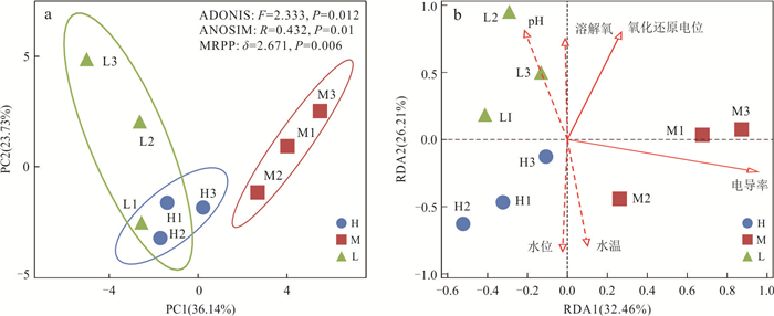
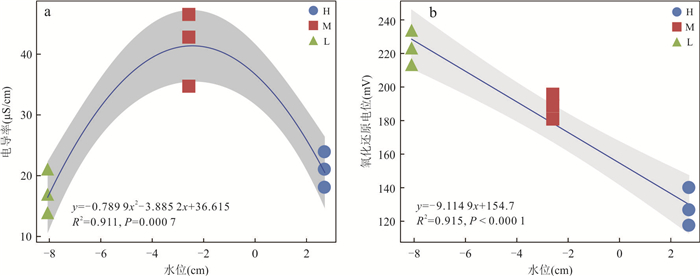
In order to investigate the characteristics of microbial carbon metabolic activity in peatlands with water table fluctuation, microbial community-level physiological profiling of peat pore water was determined with the different water table levels using Biolog-Eco microplate technology in the Dajiuhu Peatland, Shennongjia Forestry District. The results show that the rate and diversity of microbial carbon utilization at the mediate water table were the highest, followed by the low water table, with the lowest at the high water table. Esters (pyruvic acid methyl ester, Tween 40, Tween 80 and D-Galactonic acid γ-lactone), amino acids (L-arginine, L-asparagine, L-phenylalanine, L-serine and glycyl-L-glutamic acid) and amines (phenylethylamine, putrescine and N-acetyl-D-glucosamine) were the main contributors to the variations in microbial carbon utilization of peat pore water. Redundancy analysis and fitting regression model indicate that electrical conductivity (F=3.2, P=0.018) and oxidation-reduction potential (F=2.6, P=0.044) driven by water table level affected microbial carbon utilization of peat pore water. This study reveals the effect of water table fluctuation on microbial carbon utilization in peat pore water, which enriches our understanding of carbon cycle in peatlands in the context of global climate change.
In order to investigate the characteristics of microbial carbon metabolic activity in peatlands with water table fluctuation, microbial community-level physiological profiling of peat pore water was determined with the different water table levels using Biolog-Eco microplate technology in the Dajiuhu Peatland, Shennongjia Forestry District. The results show that the rate and diversity of microbial carbon utilization at the mediate water table were the highest, followed by the low water table, with the lowest at the high water table. Esters (pyruvic acid methyl ester, Tween 40, Tween 80 and D-Galactonic acid γ-lactone), amino acids (L-arginine, L-asparagine, L-phenylalanine, L-serine and glycyl-L-glutamic acid) and amines (phenylethylamine, putrescine and N-acetyl-D-glucosamine) were the main contributors to the variations in microbial carbon utilization of peat pore water. Redundancy analysis and fitting regression model indicate that electrical conductivity (F=3.2, P=0.018) and oxidation-reduction potential (F=2.6, P=0.044) driven by water table level affected microbial carbon utilization of peat pore water. This study reveals the effect of water table fluctuation on microbial carbon utilization in peat pore water, which enriches our understanding of carbon cycle in peatlands in the context of global climate change.
2024, 49(9): 3252-3263.
doi: 10.3799/dqkx.2023.109
Abstract:
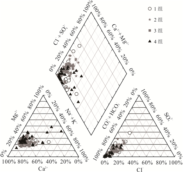
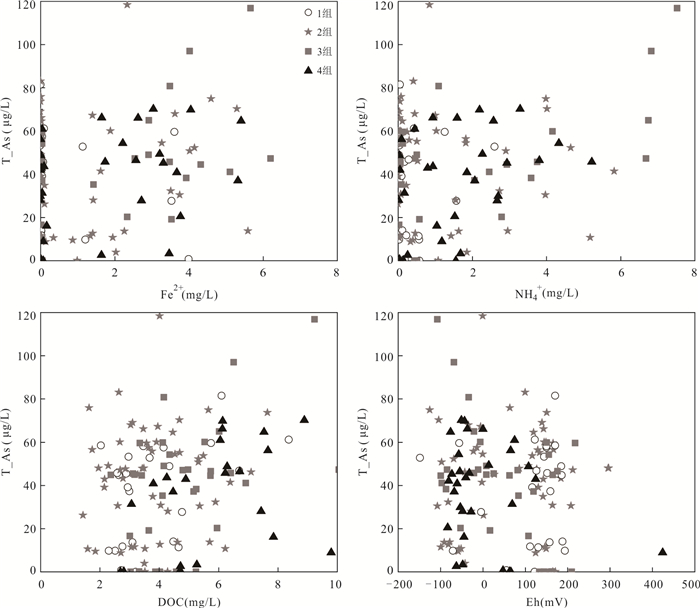
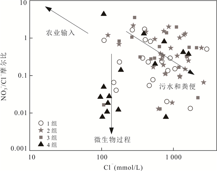
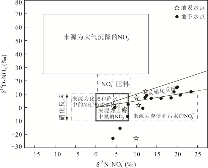
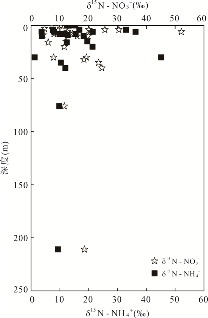
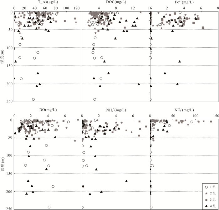
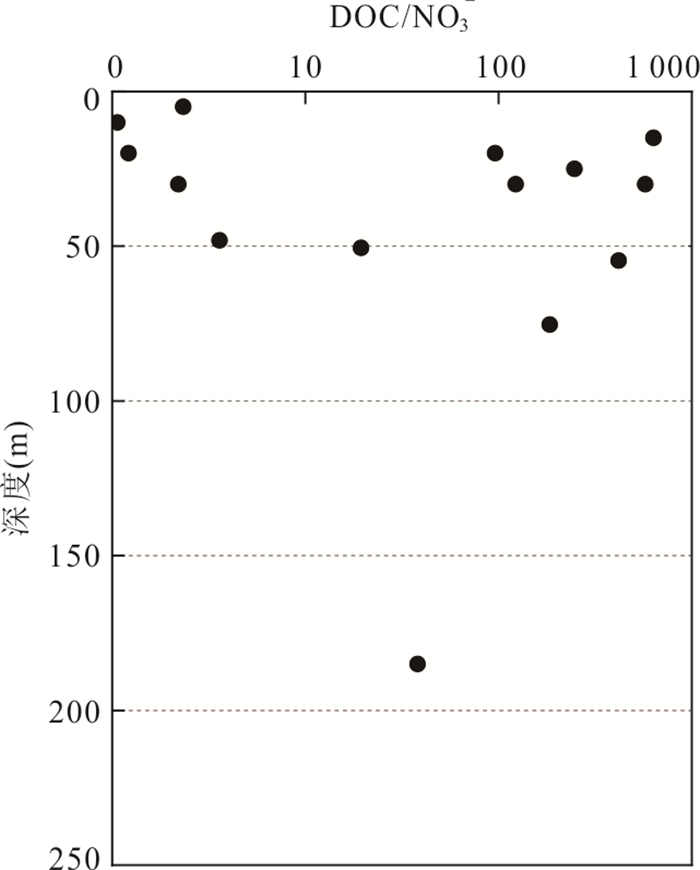
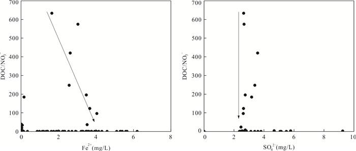
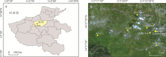
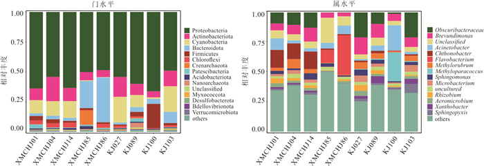
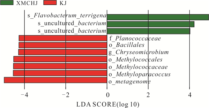
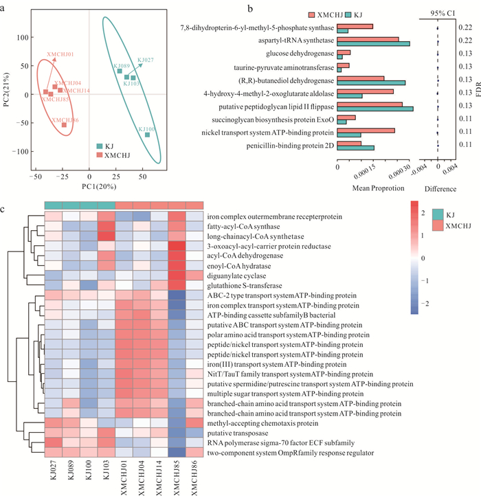
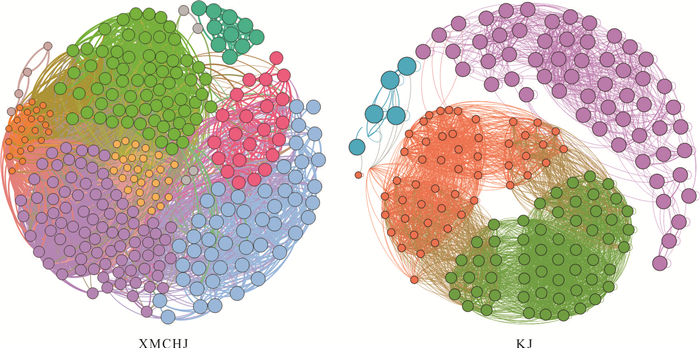
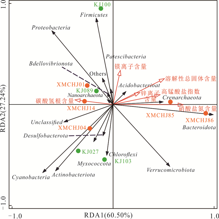
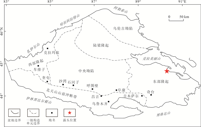
To reveal the spatial distribution characteristics and controlled factors of microorganisms in the groundwater of the coal mining area, and to lay the foundation for the ecological restoration of groundwater pollution in the coal mining area, the structure and function of microbial communities in drinking water wells and abandoned mine wells, and their responses to the local environment were analyzed by using 16S rRNA high-throughput sequencing technology in a coal mining area in Xinmi, Henan Province, China. The results show that at the genus level, drinking water wells were mainly composed of Acinetobacter, Chthonobacter and Flavobacterium, while Brevundimonas and Methylorubrum were dominant in abandoned mine wells. The significant functional differences between the two groups were in multiple synthases, dehydrogenases and ATP-binding proteins of the transporter system. Molecular ecological network analysis shows that microorganisms in mine water were not only more closely linked but also mostly positively correlated, and species might respond to the extreme oligotrophic environment by cooperation. The groundwater microbial communities in the region were mainly influenced by total dissolved solids and nitrate nitrogen content, indicating that nutrient conditions were the prerequisite factors governing the structure and function of local microbial communities.
To reveal the spatial distribution characteristics and controlled factors of microorganisms in the groundwater of the coal mining area, and to lay the foundation for the ecological restoration of groundwater pollution in the coal mining area, the structure and function of microbial communities in drinking water wells and abandoned mine wells, and their responses to the local environment were analyzed by using 16S rRNA high-throughput sequencing technology in a coal mining area in Xinmi, Henan Province, China. The results show that at the genus level, drinking water wells were mainly composed of Acinetobacter, Chthonobacter and Flavobacterium, while Brevundimonas and Methylorubrum were dominant in abandoned mine wells. The significant functional differences between the two groups were in multiple synthases, dehydrogenases and ATP-binding proteins of the transporter system. Molecular ecological network analysis shows that microorganisms in mine water were not only more closely linked but also mostly positively correlated, and species might respond to the extreme oligotrophic environment by cooperation. The groundwater microbial communities in the region were mainly influenced by total dissolved solids and nitrate nitrogen content, indicating that nutrient conditions were the prerequisite factors governing the structure and function of local microbial communities.

2024, 49(9): 3264-3275.
doi: 10.3799/dqkx.2024.022
Abstract:
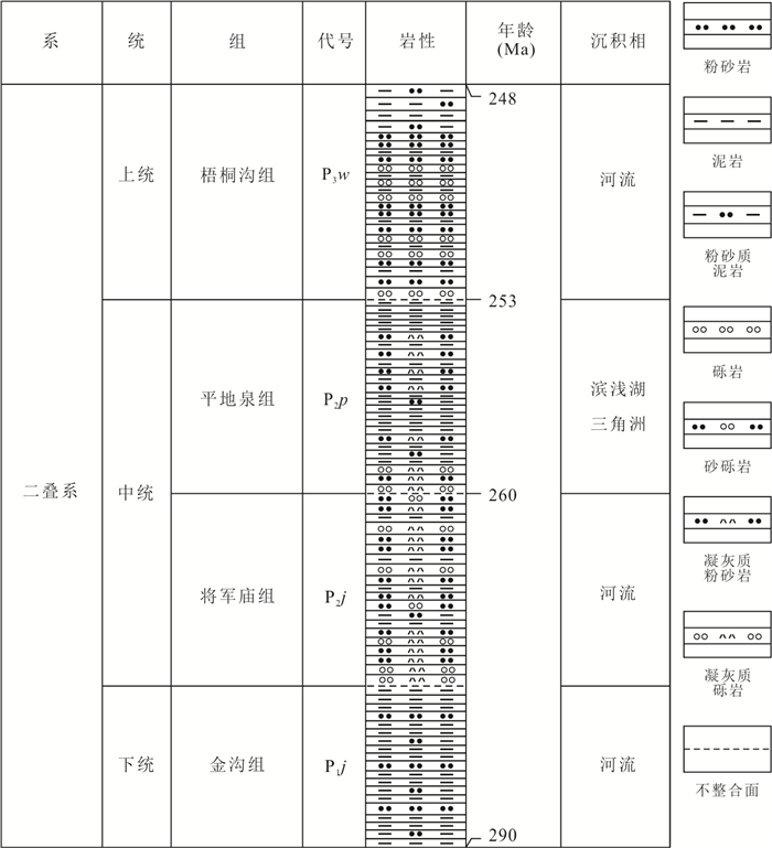
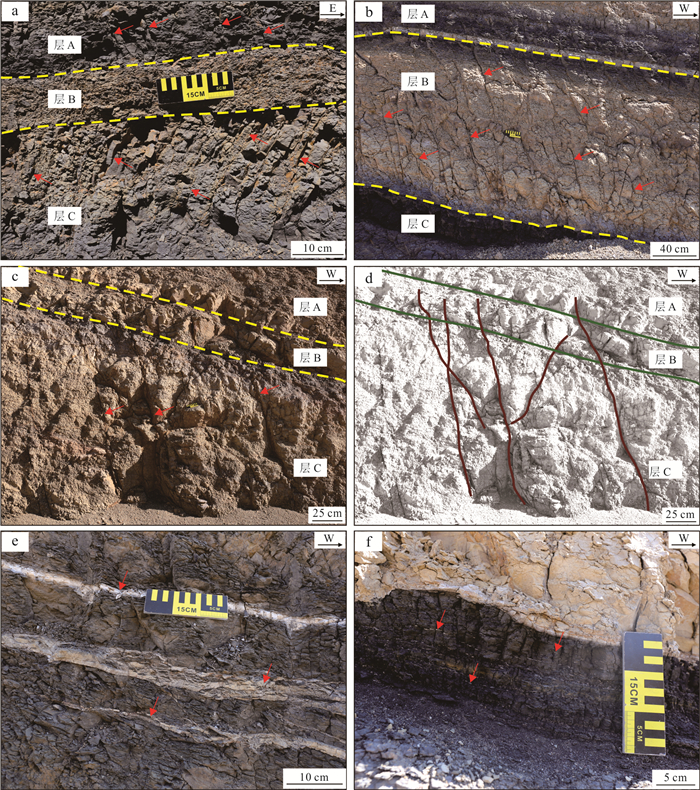
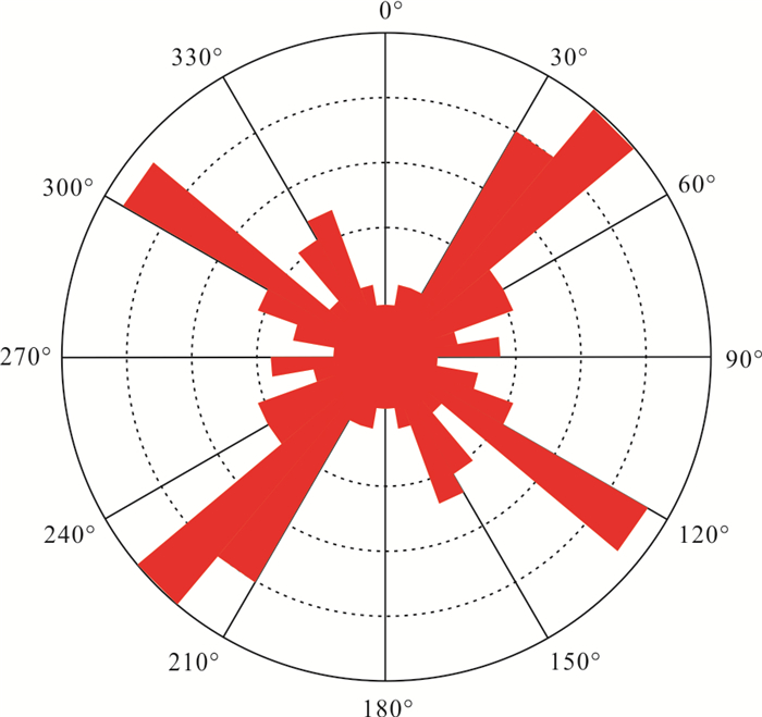
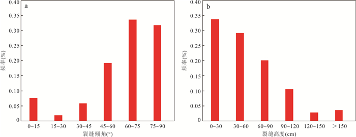
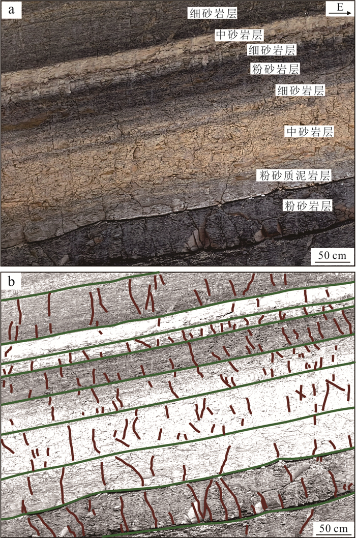
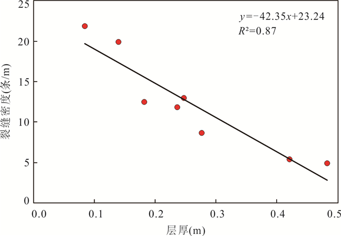
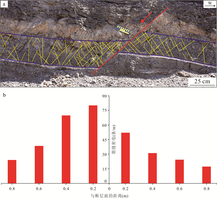
The Permian Pingdiquan Formation shale oil resources in the eastern Junggar basin are abundant, however, the exploration and development of shale oil are hindered since natural fractures serve as important storage spaces and fluid migration channels for hydrocarbons there. In this paper, the development characteristics and controlling factors of natural fractures in the Pingdiquan Formation were analyzed through detailed characterization of outcrops in the Shuangjizi area, and the distribution patterns of fractures were discussed based on these findings. The results show that the natural fractures in the Pingdiquan Formation in the Shuangjizi area of the Junggar basin include three types: bed-bounded fractures, unbounded fractures, and bed-parallel fractures, with the bed-bounded fractures being the most extensively developed and distributed. The development of natural fractures is influenced by lithology, rock mechanics layers, and structures, which is mainly manifested in: (1) the degree of development of fractures in different lithologies varies, with the most developed fractures occurring in siltstone and tuffaceous siltstone; (2) the development of fractures is controlled by rock mechanics layers, with the degree of development of natural fractures being higher in thinner rock mechanical stratigraphy; and (3) there is a fracture development zone near faults, with the degree of development of fractures being higher closer to the fault plane, on the footwall and at the end of the fault. The types and distribution characteristics of fractures differ greatly in different rock layers and structural positions, with intraformational open fractures being mostly developed in rock mechanical stratigraphy with greater brittleness, transformational shear fractures can cut through multiple sets of rock layers, and bed-parallel shear fractures mainly develop in rock layers with higher mud content. The formation and distribution of fractures are closely related to the differences in rock mechanics properties between sandstone and mudstone interbeds, as well as the thickness of mudstone interbeds.
The Permian Pingdiquan Formation shale oil resources in the eastern Junggar basin are abundant, however, the exploration and development of shale oil are hindered since natural fractures serve as important storage spaces and fluid migration channels for hydrocarbons there. In this paper, the development characteristics and controlling factors of natural fractures in the Pingdiquan Formation were analyzed through detailed characterization of outcrops in the Shuangjizi area, and the distribution patterns of fractures were discussed based on these findings. The results show that the natural fractures in the Pingdiquan Formation in the Shuangjizi area of the Junggar basin include three types: bed-bounded fractures, unbounded fractures, and bed-parallel fractures, with the bed-bounded fractures being the most extensively developed and distributed. The development of natural fractures is influenced by lithology, rock mechanics layers, and structures, which is mainly manifested in: (1) the degree of development of fractures in different lithologies varies, with the most developed fractures occurring in siltstone and tuffaceous siltstone; (2) the development of fractures is controlled by rock mechanics layers, with the degree of development of natural fractures being higher in thinner rock mechanical stratigraphy; and (3) there is a fracture development zone near faults, with the degree of development of fractures being higher closer to the fault plane, on the footwall and at the end of the fault. The types and distribution characteristics of fractures differ greatly in different rock layers and structural positions, with intraformational open fractures being mostly developed in rock mechanical stratigraphy with greater brittleness, transformational shear fractures can cut through multiple sets of rock layers, and bed-parallel shear fractures mainly develop in rock layers with higher mud content. The formation and distribution of fractures are closely related to the differences in rock mechanics properties between sandstone and mudstone interbeds, as well as the thickness of mudstone interbeds.
2024, 49(9): 3276-3291.
doi: 10.3799/dqkx.2023.085
Abstract:
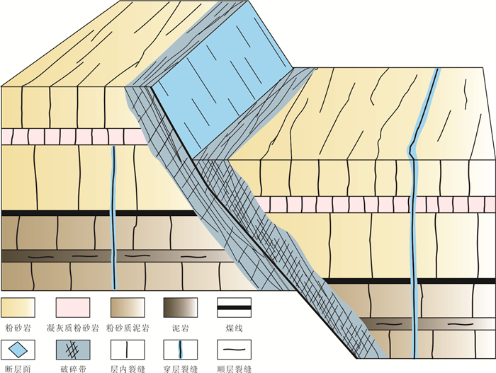
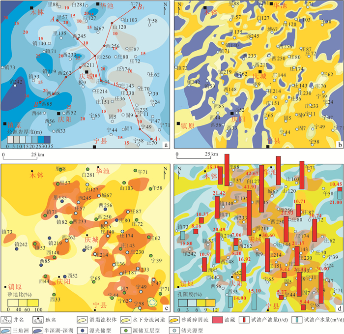
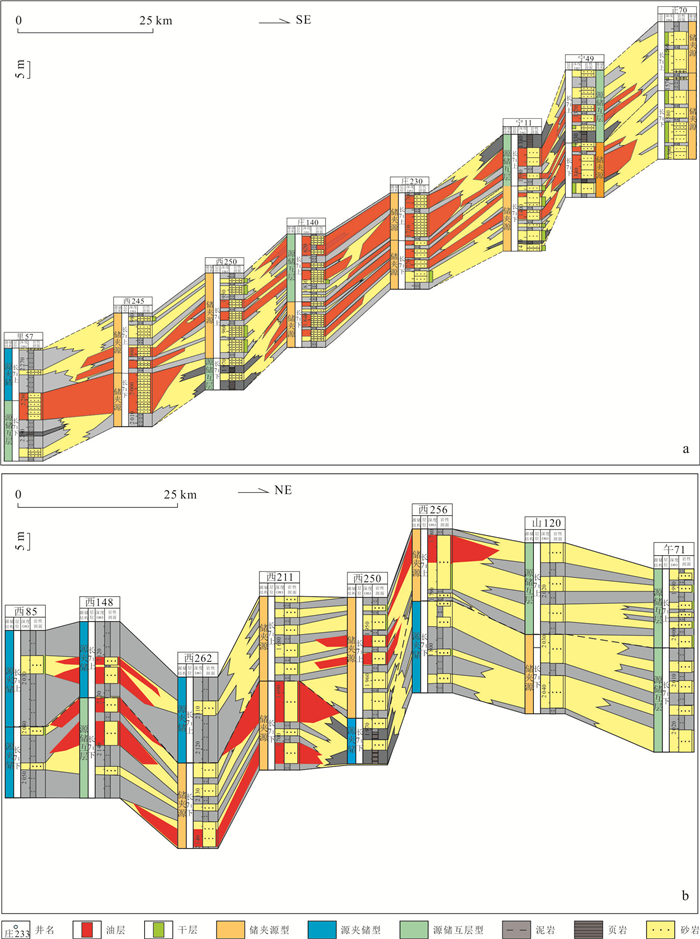
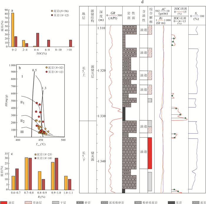
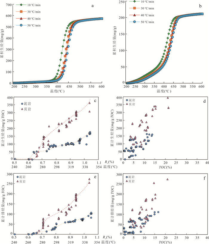
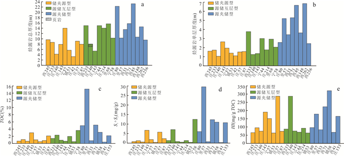
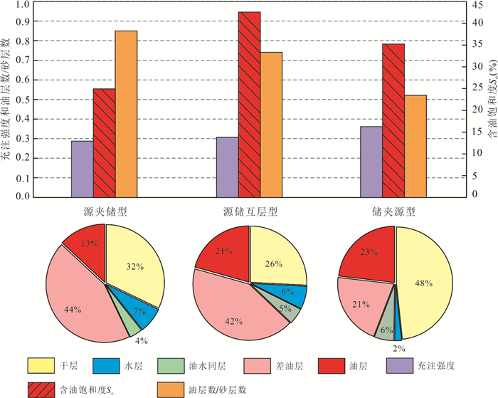
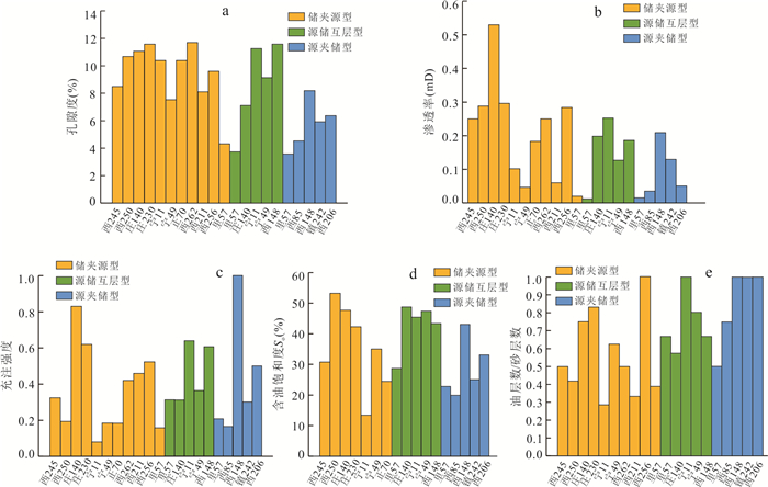
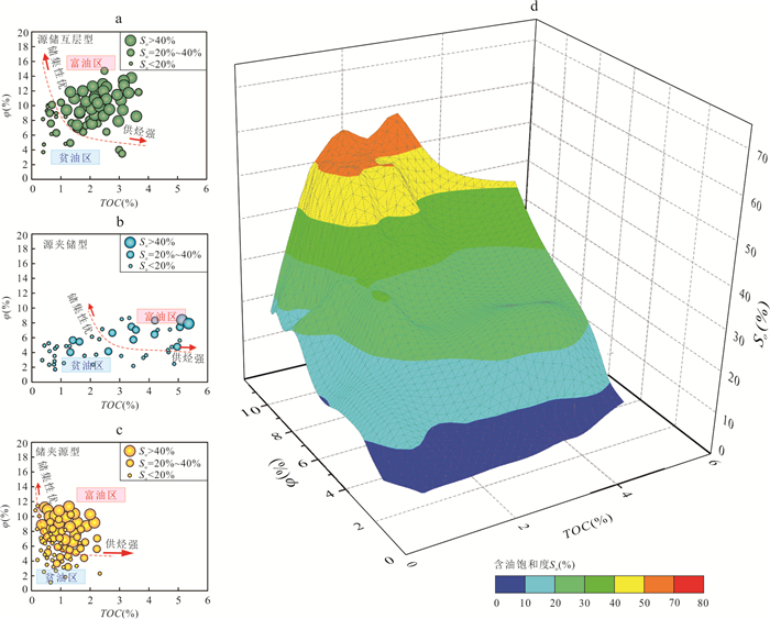
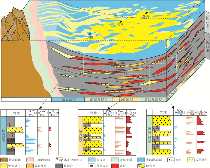
The Member 7 in the Longdong area of the Ordos basin mainly develops semi-deep lacustrine-deep lacustrine shale, which is a significant target for tight oil exploration. Based on the sand-ground ratio and lithologic thickness, the source-reservoir structures of submember 71 were systematically divided. Based on the rock pyrolysis, hydrocarbon generation thermal simulation and logging data, the source rocks' differences of different source-reservoir structures of submember 71 were evaluated, and the influence of source rocks on the oil bearing property of tight sandstone was explored. The results show that the submember 71 of Yanchang Formation can be divided into three types of primary source reservoir structures, namely reservoir sandwiching source(Type 1), source reservoir interbedding (Type 2), and source sandwiching reservoir (Type 3). The black shale has better hydrocarbon generation and expulsion ability than the dark mudstone, which leads to the result that the Type 3 structure with high source-land ratio has the best hydrocarbon generation and expulsion, followed by the Type 2 structure and Type 1 structure. The oil bearing property of tight sand in different source-reservoir structure is mainly controlled by the coupling relationship between source rock quality and reservoir physical properties. The high-quality reservoir and medium quality source rock in Type 2 structure make it stable with high oil-bearing property. For the Type 1 structure, the coupling between the high property sand bodies (> 6%) and the adjacent poor source rocks results in the large variation of oil saturation (13%-53%). The poor properties of the Type 3 structure's reservoir limit its oil enrichment.
The Member 7 in the Longdong area of the Ordos basin mainly develops semi-deep lacustrine-deep lacustrine shale, which is a significant target for tight oil exploration. Based on the sand-ground ratio and lithologic thickness, the source-reservoir structures of submember 71 were systematically divided. Based on the rock pyrolysis, hydrocarbon generation thermal simulation and logging data, the source rocks' differences of different source-reservoir structures of submember 71 were evaluated, and the influence of source rocks on the oil bearing property of tight sandstone was explored. The results show that the submember 71 of Yanchang Formation can be divided into three types of primary source reservoir structures, namely reservoir sandwiching source(Type 1), source reservoir interbedding (Type 2), and source sandwiching reservoir (Type 3). The black shale has better hydrocarbon generation and expulsion ability than the dark mudstone, which leads to the result that the Type 3 structure with high source-land ratio has the best hydrocarbon generation and expulsion, followed by the Type 2 structure and Type 1 structure. The oil bearing property of tight sand in different source-reservoir structure is mainly controlled by the coupling relationship between source rock quality and reservoir physical properties. The high-quality reservoir and medium quality source rock in Type 2 structure make it stable with high oil-bearing property. For the Type 1 structure, the coupling between the high property sand bodies (> 6%) and the adjacent poor source rocks results in the large variation of oil saturation (13%-53%). The poor properties of the Type 3 structure's reservoir limit its oil enrichment.
2024, 49(9): 3292-3305.
doi: 10.3799/dqkx.2023.093
Abstract:
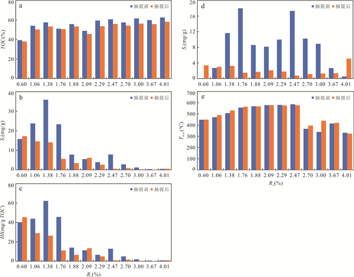
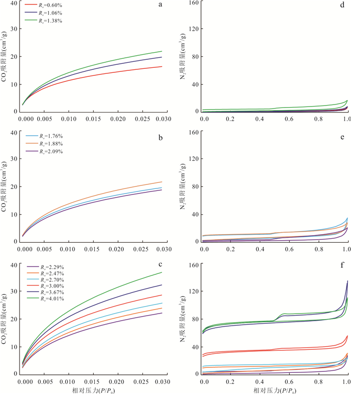
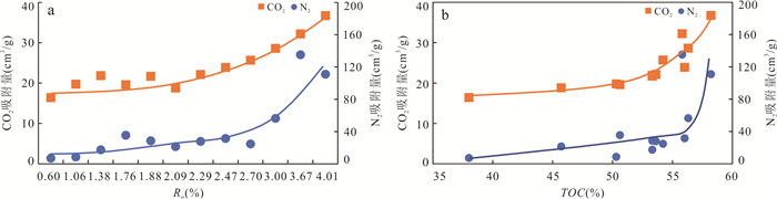
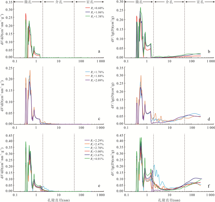
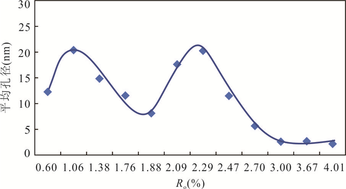
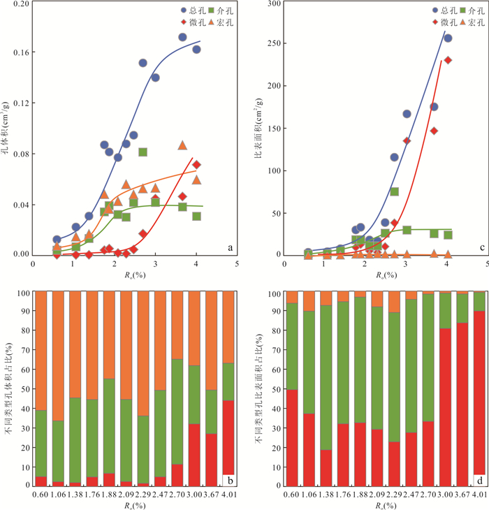
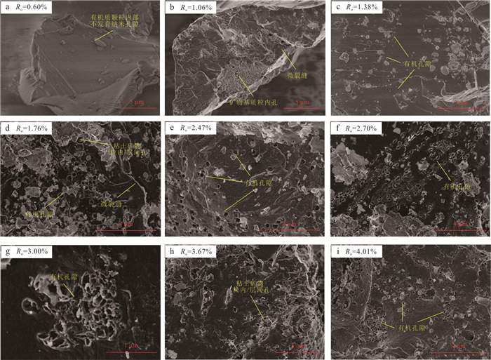
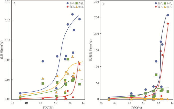
The development of organic nanopores is to some extent related to the economic benefits of unconventional natural gas reservoirs, but the influence of organic hydrocarbon generation on its formation and evolution needs in-depth study. In this paper, hydrous pyrolysis experiments were conducted on a Permian humic coal with low thermal maturity from the Ordos basin. The experimental results of TOC, Rock-Eval, gas adsorption and scanning electron microscope observation for the fresh and cocked coal samples are utilized to delineate the formation and evolution process of various nanopores within the fresh and cocked coal samples, and hence achieve a better understanding of the effects of hydrocarbon generation on the occurrence of organic nanopores from the low mature to overmature stages. The experimental results show that organic nanopores within the organic particles of pyrolyzed coal samples cannot be detected at the low mature to mature stages during which petroleum hydrocarbons were generated mainly by kerogen primary cracking. At the middle of high mature to the early of overmature stages, hydrocarbon generation from the secondary cracking of early formed crude oils resulted in the significant occurrence of various organic nanopores; At the middle to late of overmature stage, the polycondensation of aromatic rings within coal samples promoted the intensive formation of organic nanopores, in particular those with pore size < 2 nm. Accordingly, hydrocarbon secondary cracking and the polycondensation of aromatic rings within the pyrolyzed coals at high thermal maturity levels play a major role in the formation of organic nanopores. This study should be helpful to improving our understanding of the enrichment mechanisms for the deeply buried shale gas and coalbed methane.
The development of organic nanopores is to some extent related to the economic benefits of unconventional natural gas reservoirs, but the influence of organic hydrocarbon generation on its formation and evolution needs in-depth study. In this paper, hydrous pyrolysis experiments were conducted on a Permian humic coal with low thermal maturity from the Ordos basin. The experimental results of TOC, Rock-Eval, gas adsorption and scanning electron microscope observation for the fresh and cocked coal samples are utilized to delineate the formation and evolution process of various nanopores within the fresh and cocked coal samples, and hence achieve a better understanding of the effects of hydrocarbon generation on the occurrence of organic nanopores from the low mature to overmature stages. The experimental results show that organic nanopores within the organic particles of pyrolyzed coal samples cannot be detected at the low mature to mature stages during which petroleum hydrocarbons were generated mainly by kerogen primary cracking. At the middle of high mature to the early of overmature stages, hydrocarbon generation from the secondary cracking of early formed crude oils resulted in the significant occurrence of various organic nanopores; At the middle to late of overmature stage, the polycondensation of aromatic rings within coal samples promoted the intensive formation of organic nanopores, in particular those with pore size < 2 nm. Accordingly, hydrocarbon secondary cracking and the polycondensation of aromatic rings within the pyrolyzed coals at high thermal maturity levels play a major role in the formation of organic nanopores. This study should be helpful to improving our understanding of the enrichment mechanisms for the deeply buried shale gas and coalbed methane.
2024, 49(9): 3306-3317.
doi: 10.3799/dqkx.2023.151
Abstract:
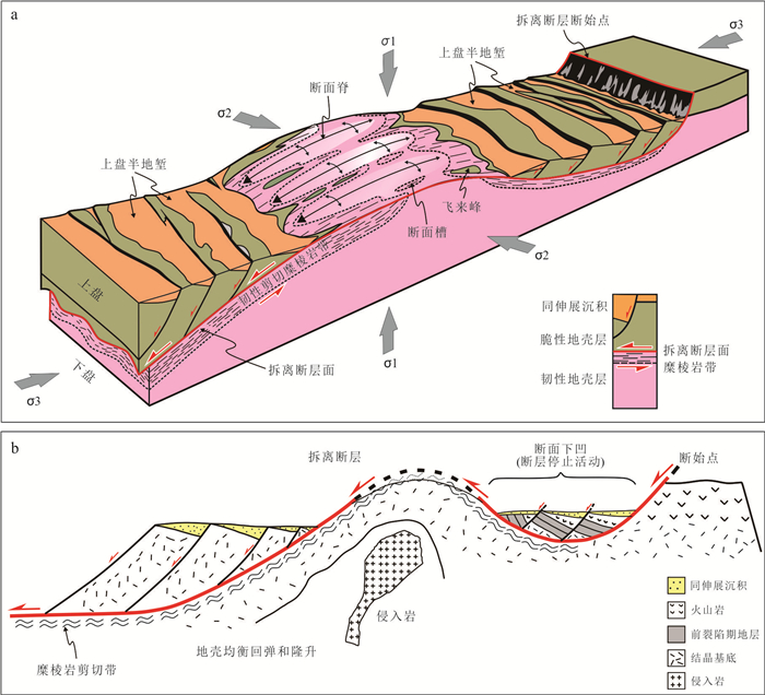
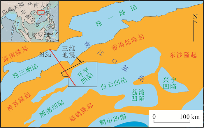
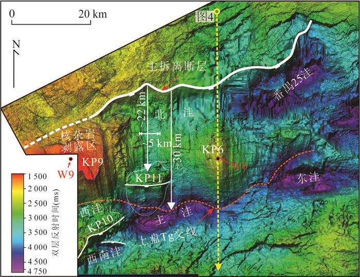
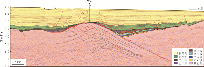
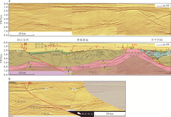
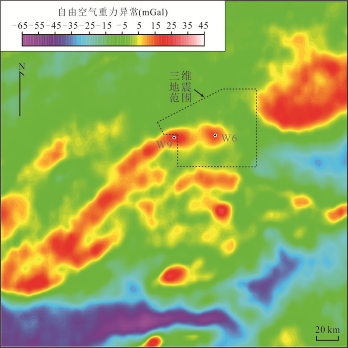
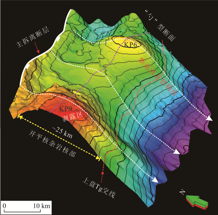
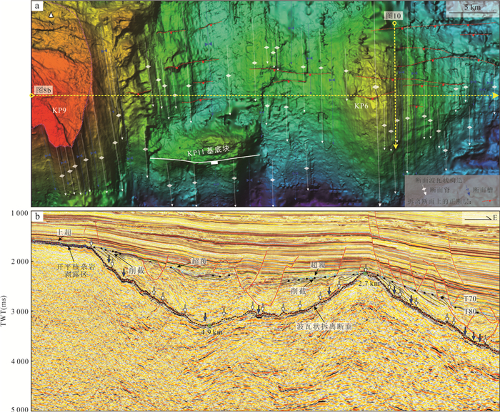
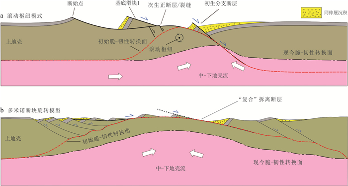
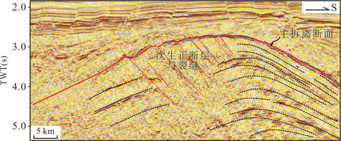
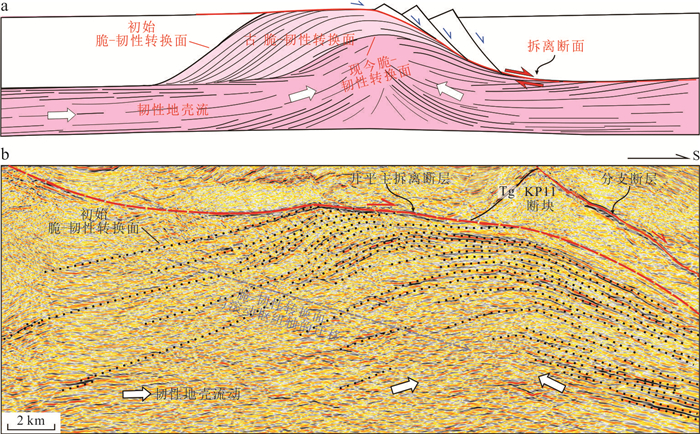
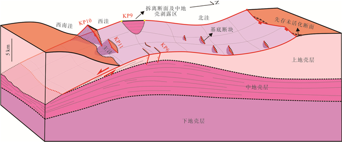
The Kaiping sag within the Pearl River Mouth basin, northern South China Sea rifted margin, shows a complex rift structure, and the rift structure and dynamics are the main factors that hinder our understanding on the petroleum geology and exploration process in this area. Based on the newly acquired 3D seismic reflection data, this study investigates the structure of the Kaiping sag, the geometric and kinematic characteristics of boundary faults, and the deep lithospheric structure. It is revealed that the Kaiping sag has a detachment structure related to core complex, and the E-W extending dome structure in the central part of the Kaiping sag is a standard oceanic core complex structure. The development of the core complex is related to the uplift of the ductile crust, which is exposed and truncated at the KP9 high. The detachment in the context of core complex uplifting controls the structural styles and sedimentary filling process in the Kaiping sag. The development of the Kaiping core complex shows a standard rolling-hinge model, and the domed layered seismic reflectors within the crust represent the brittle-ductile transition surface in geological history, which has a direction of migration same with the hanging-wall movement. The main detachment fault shows "spoon-shaped", and a large number of SN-trending corrugations on the detachment surface indicate top down to the south slip of the hanging wall. The development of oceanic core complexes in the Kaiping sag is closely related to the existence of a weak middle crust layer within the initial lithosphere in this area. This research offers a new explanation on the rift structure and dynamics of the Kaiping sag, which has promoted the understanding on source rocks and hydrocarbon accumulation and provided important guidance for the first commercial exploration breakthrough in forty years.
The Kaiping sag within the Pearl River Mouth basin, northern South China Sea rifted margin, shows a complex rift structure, and the rift structure and dynamics are the main factors that hinder our understanding on the petroleum geology and exploration process in this area. Based on the newly acquired 3D seismic reflection data, this study investigates the structure of the Kaiping sag, the geometric and kinematic characteristics of boundary faults, and the deep lithospheric structure. It is revealed that the Kaiping sag has a detachment structure related to core complex, and the E-W extending dome structure in the central part of the Kaiping sag is a standard oceanic core complex structure. The development of the core complex is related to the uplift of the ductile crust, which is exposed and truncated at the KP9 high. The detachment in the context of core complex uplifting controls the structural styles and sedimentary filling process in the Kaiping sag. The development of the Kaiping core complex shows a standard rolling-hinge model, and the domed layered seismic reflectors within the crust represent the brittle-ductile transition surface in geological history, which has a direction of migration same with the hanging-wall movement. The main detachment fault shows "spoon-shaped", and a large number of SN-trending corrugations on the detachment surface indicate top down to the south slip of the hanging wall. The development of oceanic core complexes in the Kaiping sag is closely related to the existence of a weak middle crust layer within the initial lithosphere in this area. This research offers a new explanation on the rift structure and dynamics of the Kaiping sag, which has promoted the understanding on source rocks and hydrocarbon accumulation and provided important guidance for the first commercial exploration breakthrough in forty years.
2024, 49(9): 3318-3333.
doi: 10.3799/dqkx.2023.099
Abstract:
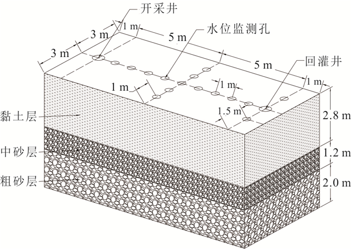
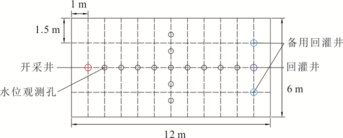
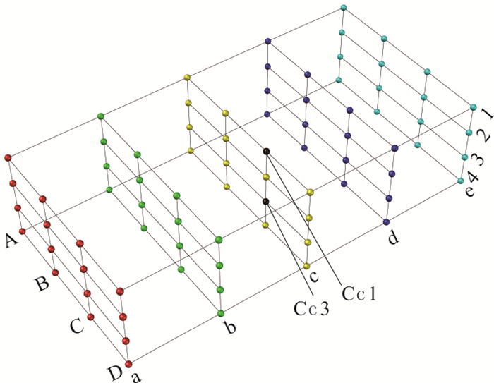
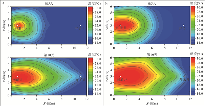
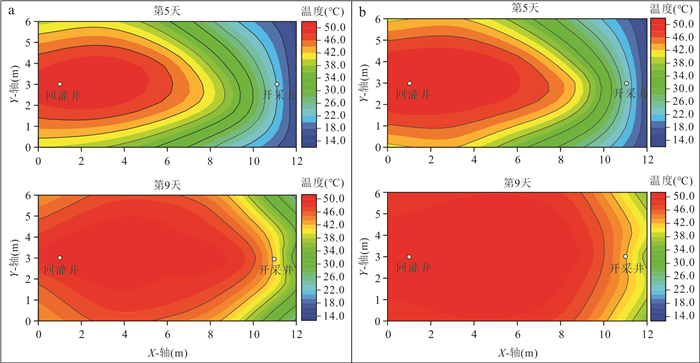
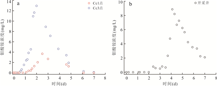
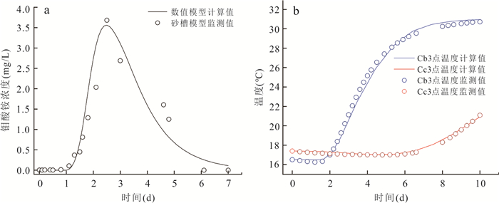
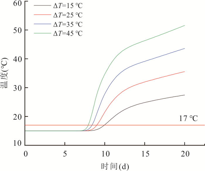
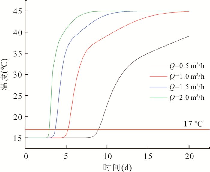
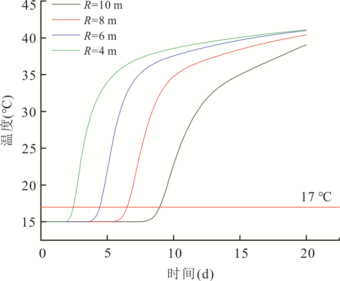
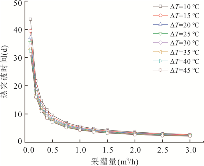
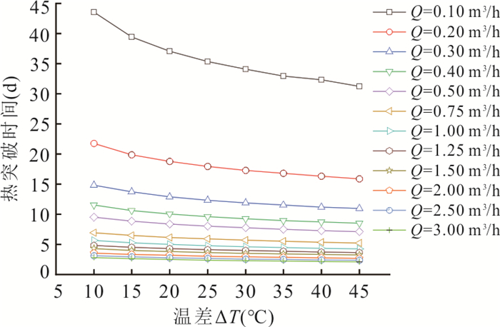
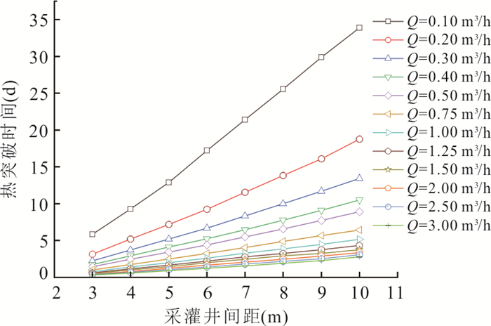
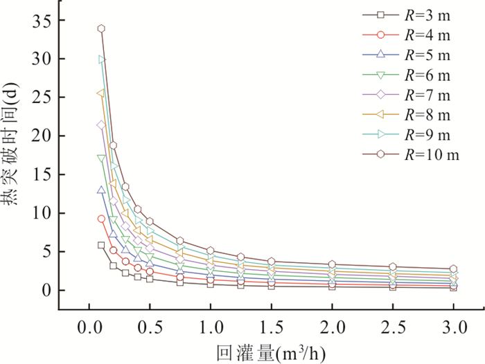
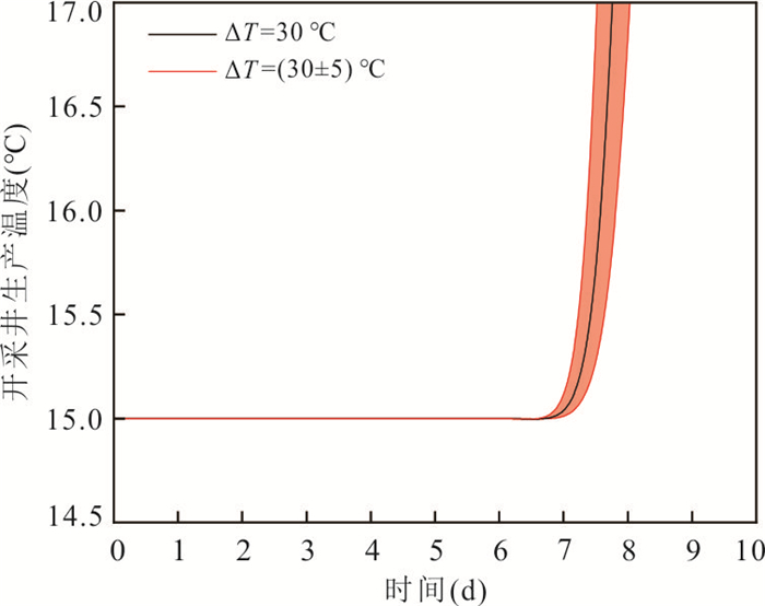
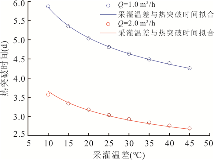
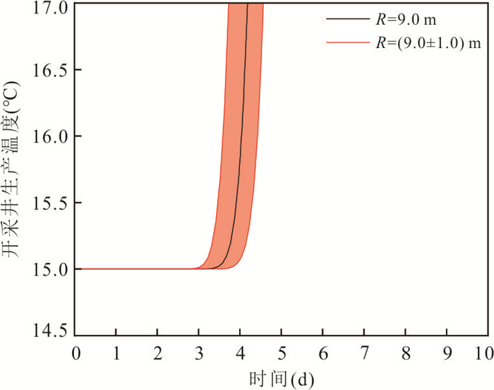
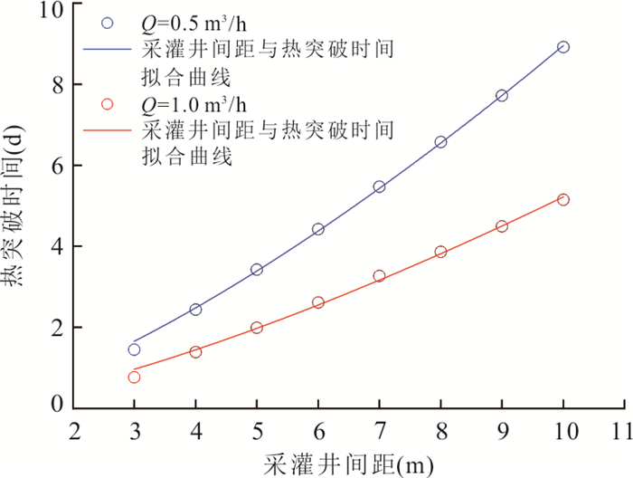
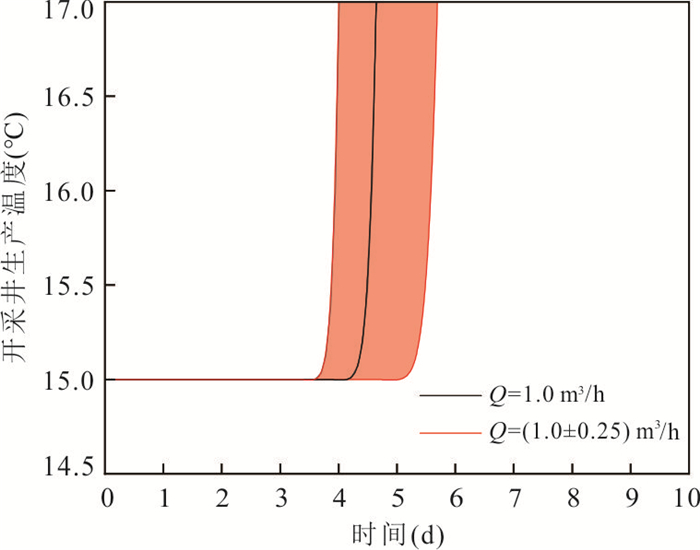
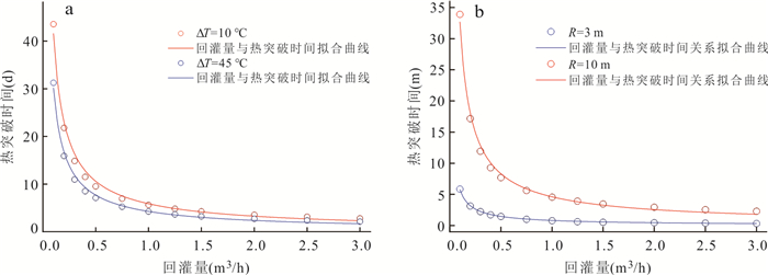
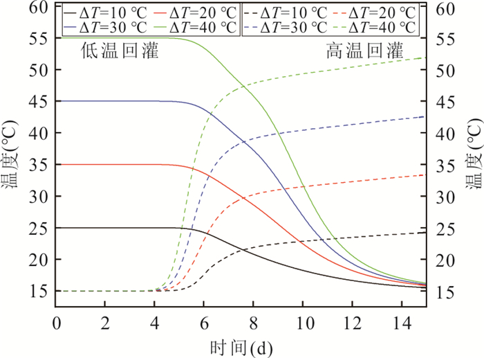
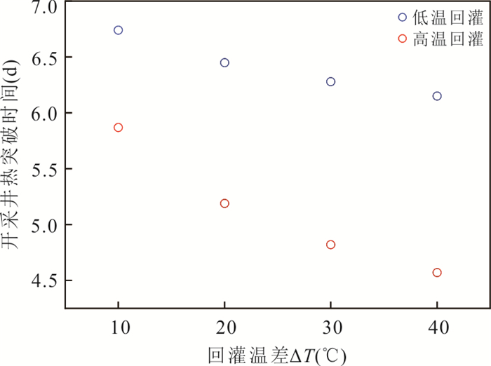
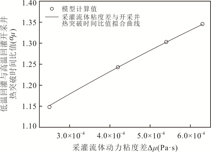
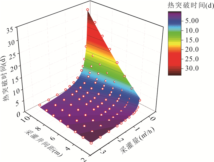
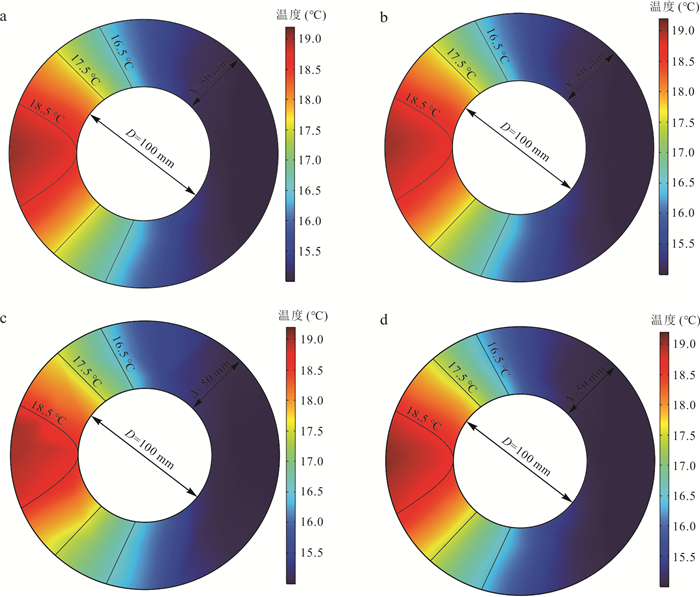
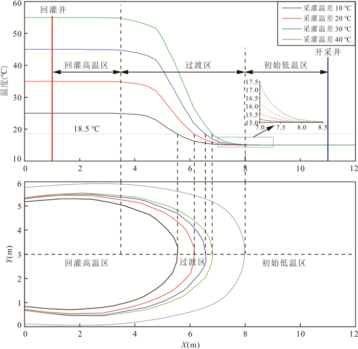
The evolution of geo-temperature within the geothermal reservoir induced by reinjection of geothermal cooled water is of great importance for the sustainable utilization of geothermal resources. This study focuses on examining the quantitative relationship between reinjection parameters and the thermal breakthrough time of production wells. A simulation test using a large sand tank combined with numerical simulation methods was conducted. Permeation tests, tracer tests, and reinjection tests were performed in the simulation test model. Additionally, sensitivity analysis and nonlinear fitting were carried out to discuss the impact of fluid viscosity and density on reinjection results, as well as the degree of influence of reinjection parameters on the thermal breakthrough time of production wells and its underlying mechanisms and principles. The results show that the migration speed of reinjection water is different in sand reservoirs with different permeability, and the thermal breakthrough time t is linearly correlated with Q‒0.85, ΔT‒0.21, and R1.4. The correlation equation and analysis show that when the temperature difference between production and reinjection ΔT is more than 30 ℃, the influence of ΔT on the thermal breakthrough time of production well becomes weak, because ΔT exerts an effect on the thermal breakthrough time of production well t by influencing the relative position of the 18.5 ℃ isotherm in the temperature transition region, and the error for reinjection from high temperature fluid to low temperature fluid can be corrected by introducing the viscosity correction coefficient αμ.
The evolution of geo-temperature within the geothermal reservoir induced by reinjection of geothermal cooled water is of great importance for the sustainable utilization of geothermal resources. This study focuses on examining the quantitative relationship between reinjection parameters and the thermal breakthrough time of production wells. A simulation test using a large sand tank combined with numerical simulation methods was conducted. Permeation tests, tracer tests, and reinjection tests were performed in the simulation test model. Additionally, sensitivity analysis and nonlinear fitting were carried out to discuss the impact of fluid viscosity and density on reinjection results, as well as the degree of influence of reinjection parameters on the thermal breakthrough time of production wells and its underlying mechanisms and principles. The results show that the migration speed of reinjection water is different in sand reservoirs with different permeability, and the thermal breakthrough time t is linearly correlated with Q‒0.85, ΔT‒0.21, and R1.4. The correlation equation and analysis show that when the temperature difference between production and reinjection ΔT is more than 30 ℃, the influence of ΔT on the thermal breakthrough time of production well becomes weak, because ΔT exerts an effect on the thermal breakthrough time of production well t by influencing the relative position of the 18.5 ℃ isotherm in the temperature transition region, and the error for reinjection from high temperature fluid to low temperature fluid can be corrected by introducing the viscosity correction coefficient αμ.
2024, 49(9): 3334-3346.
doi: 10.3799/dqkx.2023.083
Abstract:
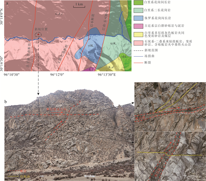
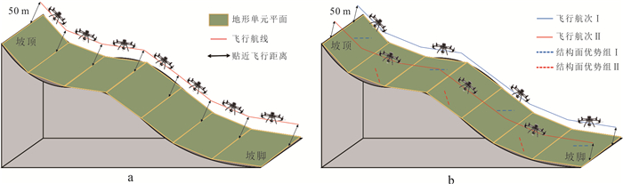
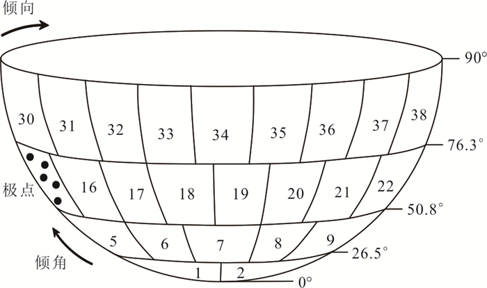
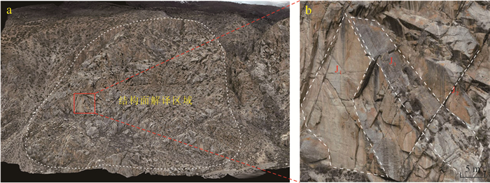
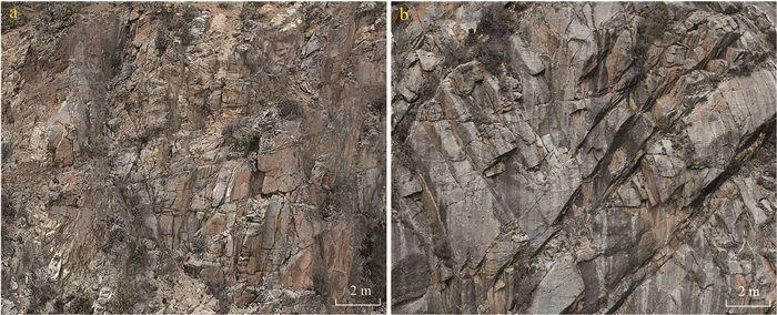
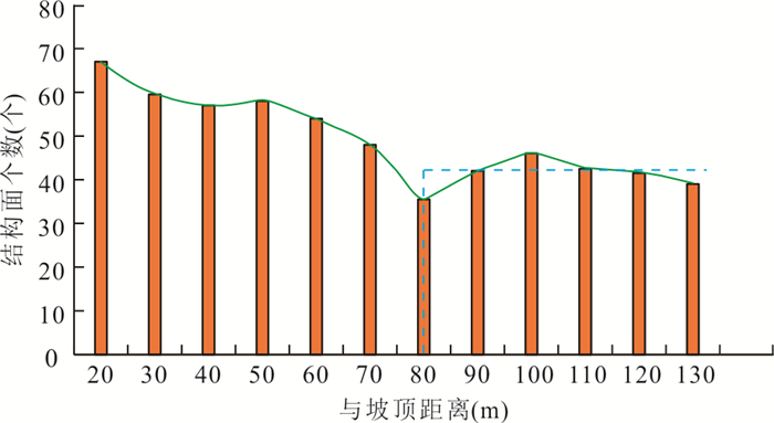
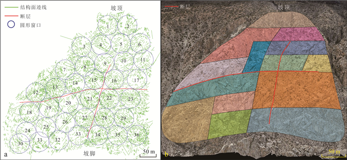
In order to reasonably demarcate the structural homogeneity according to the spatial distribution characteristics of the structural plane, this paper takes the high-steep rock slope of the left bank of Dongcuoqu, Chada Village, Luolong County, Changdu City, Xizang as the research object, adopts the multi-angle nap-of-the-object photography technology to obtain the high-precision image data of the study area and realize the reconstruction of slope 3D real scene model and the interpretation of structural plane information. Based on plenty of structural plane investigations, the development and genetic mechanism of structural plane are analyzed. On the basis of the spatial distribution characteristics of discontinuities with considering the orientation and density, the intraclass correlation coefficient method was introduced, combined with Schmidt plot divided into 38 equal areas, to divide structural homogeneity of rock mass and compared with Pearson's correlation coefficient method. The results show that the slope structure is controlled by tectonic stress field, fault and weathering, with the orientation and density of structural plane distributed differently in space. In addition, the slope is finally divided into 14 different homogeneous zones. In view of the characteristics of spatial differentiation of the orientation and density of structural plane, Pearson's correlation coefficient method has a weak ability to discriminate the homogeneity between samples, while the intraclass correlation coefficient method has a better evaluation effect, which is more suitable for the division of statistical homogeneity of complex rock structure with certain application value.
In order to reasonably demarcate the structural homogeneity according to the spatial distribution characteristics of the structural plane, this paper takes the high-steep rock slope of the left bank of Dongcuoqu, Chada Village, Luolong County, Changdu City, Xizang as the research object, adopts the multi-angle nap-of-the-object photography technology to obtain the high-precision image data of the study area and realize the reconstruction of slope 3D real scene model and the interpretation of structural plane information. Based on plenty of structural plane investigations, the development and genetic mechanism of structural plane are analyzed. On the basis of the spatial distribution characteristics of discontinuities with considering the orientation and density, the intraclass correlation coefficient method was introduced, combined with Schmidt plot divided into 38 equal areas, to divide structural homogeneity of rock mass and compared with Pearson's correlation coefficient method. The results show that the slope structure is controlled by tectonic stress field, fault and weathering, with the orientation and density of structural plane distributed differently in space. In addition, the slope is finally divided into 14 different homogeneous zones. In view of the characteristics of spatial differentiation of the orientation and density of structural plane, Pearson's correlation coefficient method has a weak ability to discriminate the homogeneity between samples, while the intraclass correlation coefficient method has a better evaluation effect, which is more suitable for the division of statistical homogeneity of complex rock structure with certain application value.
2024, 49(9): 3347-3362.
doi: 10.3799/dqkx.2023.025
Abstract:
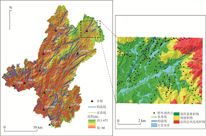
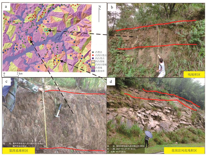
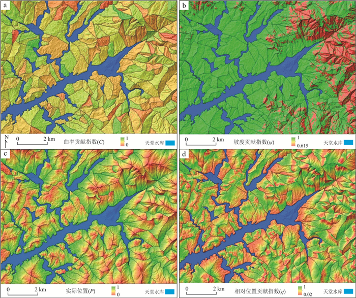
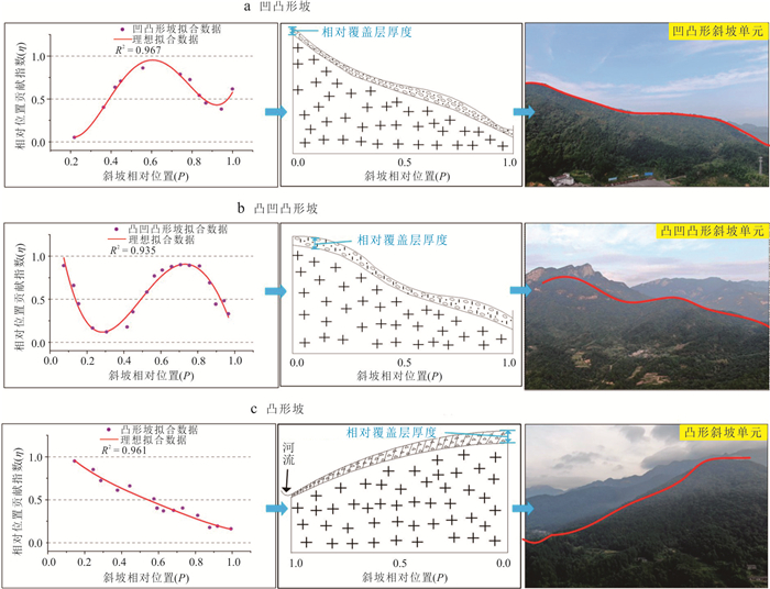
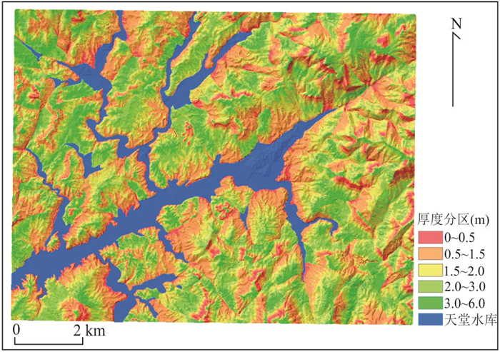
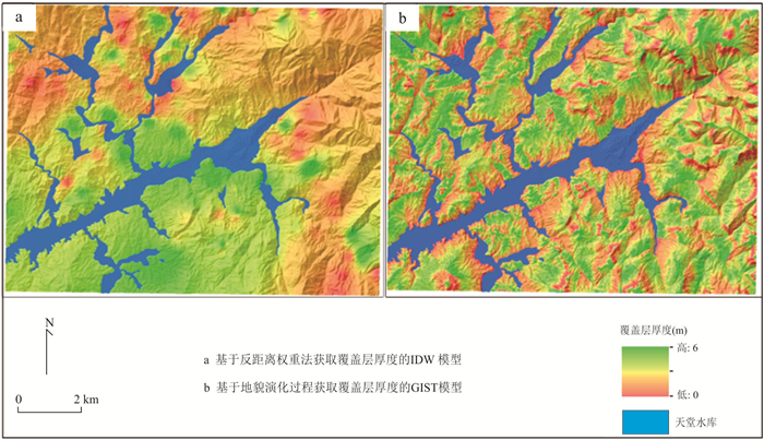
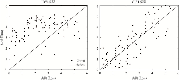
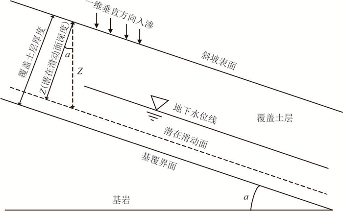
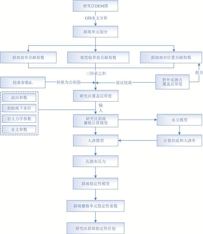
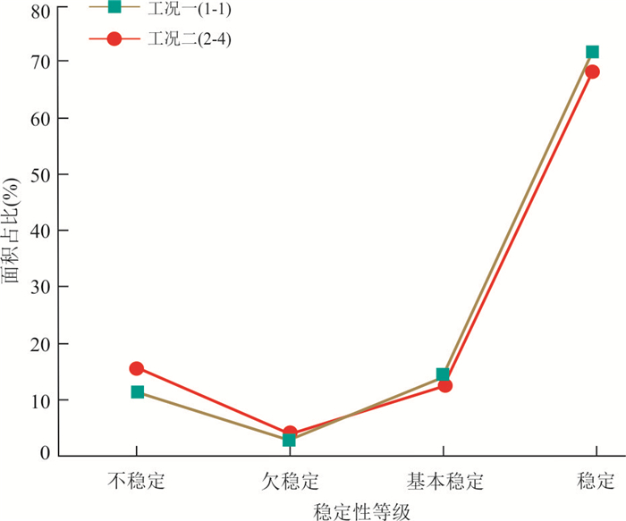
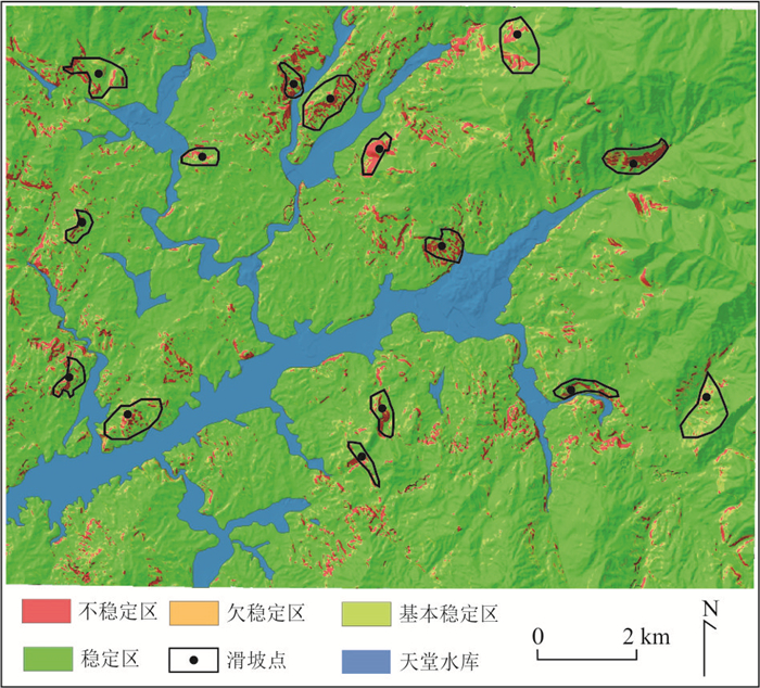
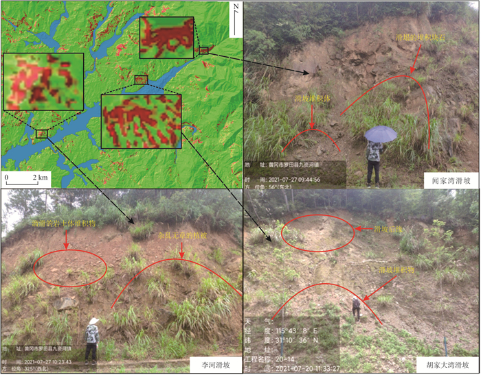
The overburden layer in the region conceives the shallow surface damage of slopes and is the main source for the regional slope damage. But, the spatial variation in the thickness of the overburden layer makes it difficult to reasonably determine the bottom of hazard development, which in turn makes it difficult for the stability assessment results to indicate actual landslide conditions. Taking Jiuzihe Town of Huanggang City as an example, the overburden thickness in this area was investigated in detail, and the spatial distribution of overburden thickness was determined by a geomorphic process-based method. On this basis, the stability of slopes in the study area under rainfall conditions was analyzed using a quantitative model of slope stability, and the distribution and likelihood of regional accumulated layer landslide were estimated accordingly. The results show that the proposed method is effective and highly practical, and that the estimated regional overburden thickness based on GIST model is close to the actual situation, mainly concentrated in 0.5-3.0 m. The reasonable determination of overburden thickness makes the evaluation results of regional slope rainfall infiltration stability more precise and has practical landslide indication significance. The basically stable and stable slopes are mainly distributed in the areas with large overburden thickness but small slope, such as terrace platform or floodplain. While the less stable and unstable slopes are mainly distributed in the reservoir and the bank of various tributaries. Short period of heavy rainfall has great influence on slope stability. This study is helpful to the development of regional slope disaster assessment towards the fine direction.
The overburden layer in the region conceives the shallow surface damage of slopes and is the main source for the regional slope damage. But, the spatial variation in the thickness of the overburden layer makes it difficult to reasonably determine the bottom of hazard development, which in turn makes it difficult for the stability assessment results to indicate actual landslide conditions. Taking Jiuzihe Town of Huanggang City as an example, the overburden thickness in this area was investigated in detail, and the spatial distribution of overburden thickness was determined by a geomorphic process-based method. On this basis, the stability of slopes in the study area under rainfall conditions was analyzed using a quantitative model of slope stability, and the distribution and likelihood of regional accumulated layer landslide were estimated accordingly. The results show that the proposed method is effective and highly practical, and that the estimated regional overburden thickness based on GIST model is close to the actual situation, mainly concentrated in 0.5-3.0 m. The reasonable determination of overburden thickness makes the evaluation results of regional slope rainfall infiltration stability more precise and has practical landslide indication significance. The basically stable and stable slopes are mainly distributed in the areas with large overburden thickness but small slope, such as terrace platform or floodplain. While the less stable and unstable slopes are mainly distributed in the reservoir and the bank of various tributaries. Short period of heavy rainfall has great influence on slope stability. This study is helpful to the development of regional slope disaster assessment towards the fine direction.
2024, 49(9): 3363-3376.
doi: 10.3799/dqkx.2023.096
Abstract:
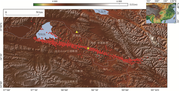
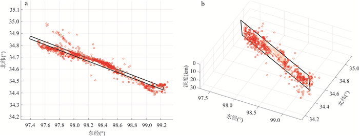
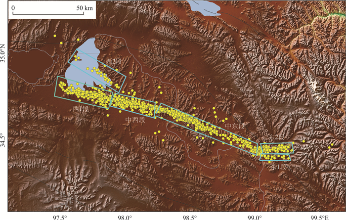
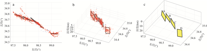
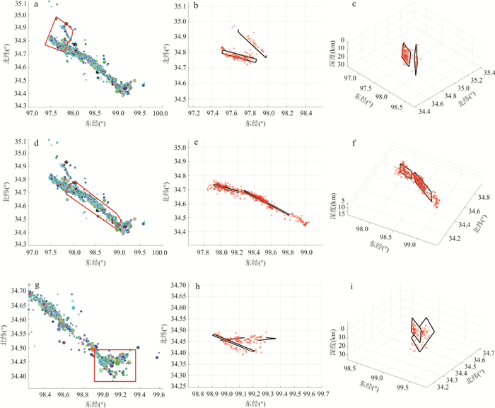
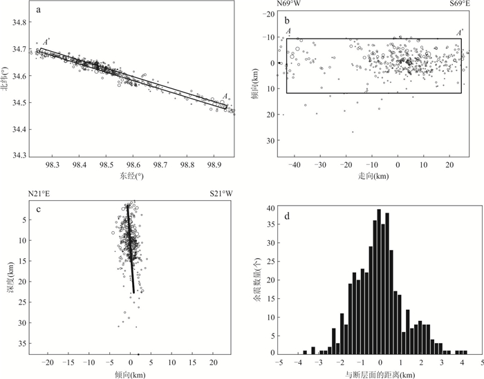
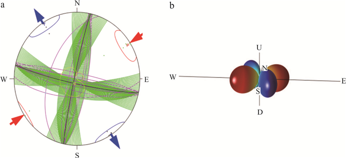
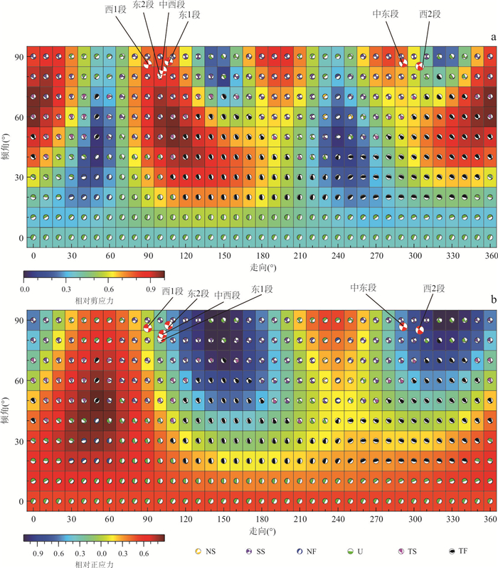
To gain a deeper understanding of the geological structure in the Maduo region of Qinghai, it is crucial to accurately determine the shapes and parameters of each branch fault planes in the area. Based on the principle that clusters of small earthquakes occur near the fault plane, by using the fuzzy clustering algorithm to cluster the seismic event, the geometry parameters of the fault planes of the 2021 Ms7.4 Qinghai Maduo earthquake sequence are determined. By projecting the stress field in study area onto the obtained fault planes, the relative shear stress and normal stress of each fault plane are obtained. The results show that the overall fault plane of these 2021 Maduo earthquake is mainly distributed on the Kunlun Pass-Jiangcuo fault, with rupture length of 163.71 km, strike of 285.81°, and dip angle of 85.62°. There are obvious bifurcations on the east and west sides of the earthquake distribution area. For the complex fault structure, we made various attempts through the fuzzy clustering algorithm, and obtained the fault plane solution by fuzzy clustering with 6 fault planes. By projecting the tectonic stress field onto the 6 obtained fault planes, we found that the relative shear stress on these fault planes is generally greater than the relative normal stress. Therefore, it is speculated that the earthquake was mainly caused by the tectonic stress field, and the small fault in the north branch at the western end of the bifurcation is the branch rupture caused by the main rupture. Due to the left-lateral strike-slip nature of this rupture, tail extension appeared in the northeastern part of the eastern segment of the fault, resulting in the formation of the 2 small faults on the bifurcation of the eastern segment. The fault parameters obtained by the fuzzy clustering method in this study are also highly consistent with the data of other authors and institutions. This method is an accurate and maneuverable method to obtain fault plane information based on a large amount of seismic sequence data. This method will have important significance for seismic structure, fault plane determination and analysis in the future.
To gain a deeper understanding of the geological structure in the Maduo region of Qinghai, it is crucial to accurately determine the shapes and parameters of each branch fault planes in the area. Based on the principle that clusters of small earthquakes occur near the fault plane, by using the fuzzy clustering algorithm to cluster the seismic event, the geometry parameters of the fault planes of the 2021 Ms7.4 Qinghai Maduo earthquake sequence are determined. By projecting the stress field in study area onto the obtained fault planes, the relative shear stress and normal stress of each fault plane are obtained. The results show that the overall fault plane of these 2021 Maduo earthquake is mainly distributed on the Kunlun Pass-Jiangcuo fault, with rupture length of 163.71 km, strike of 285.81°, and dip angle of 85.62°. There are obvious bifurcations on the east and west sides of the earthquake distribution area. For the complex fault structure, we made various attempts through the fuzzy clustering algorithm, and obtained the fault plane solution by fuzzy clustering with 6 fault planes. By projecting the tectonic stress field onto the 6 obtained fault planes, we found that the relative shear stress on these fault planes is generally greater than the relative normal stress. Therefore, it is speculated that the earthquake was mainly caused by the tectonic stress field, and the small fault in the north branch at the western end of the bifurcation is the branch rupture caused by the main rupture. Due to the left-lateral strike-slip nature of this rupture, tail extension appeared in the northeastern part of the eastern segment of the fault, resulting in the formation of the 2 small faults on the bifurcation of the eastern segment. The fault parameters obtained by the fuzzy clustering method in this study are also highly consistent with the data of other authors and institutions. This method is an accurate and maneuverable method to obtain fault plane information based on a large amount of seismic sequence data. This method will have important significance for seismic structure, fault plane determination and analysis in the future.
2024, 49(9): 3377-3386.
doi: 10.3799/dqkx.2023.101
Abstract:
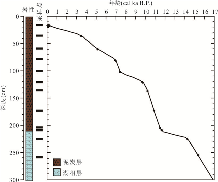
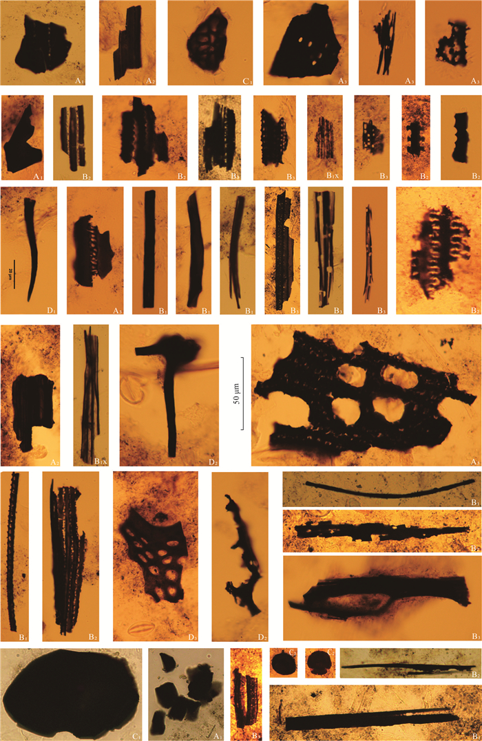
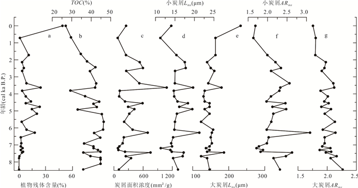
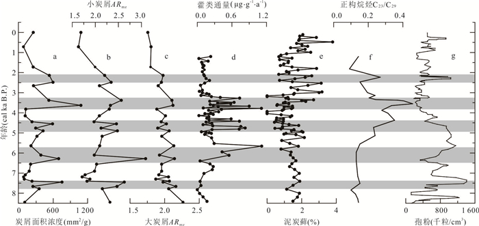
As the product of incomplete combustion of plants, fossil charcoal records the information of parent plants and paleofire events. In this paper, the morphology, concentration and aspect ratio of charcoal in deposits of the Dajiuhu peatland were analyzed and compared with other biogenic paleoenvironmental proxies, such as hopanoids flux and pollen, in order to reveal the paleofire and paleoenvironmental significance. The results show that the parent source information of charcoal can be identified by its geometric shape, surface texture and stomatal structure. The intensity of paleofires and the change of burning fuel types can be revealed by the concentration and aspect ratio of charcoal with obvious changes. These variations can be divided into two stages. During the Mid-Holocene period (approximately 8.5-4.3 ka B.P.), charcoal concentrations were generally high in association with drought climates; which means that paleofire events coincided with obvious drought events. However, during the period from 7.3 to 7.0 ka B.P., charcoal concentrations were low due to frequent rainfall restriction. In the Late Holocene (Since approximately 4.3 ka B.P.), transitioning from a dry to wet climate has led to decreased fluctuations in charcoal content. However, anomalies occurred around 3.6 ka B.P. and 2.5 ka B.P., indicating that fire frequency in humid background are closely related to drought events. Therefore, these findings suggest that charcoal can be used as a proxy paleofire associated with aridification in alpine peatland.
As the product of incomplete combustion of plants, fossil charcoal records the information of parent plants and paleofire events. In this paper, the morphology, concentration and aspect ratio of charcoal in deposits of the Dajiuhu peatland were analyzed and compared with other biogenic paleoenvironmental proxies, such as hopanoids flux and pollen, in order to reveal the paleofire and paleoenvironmental significance. The results show that the parent source information of charcoal can be identified by its geometric shape, surface texture and stomatal structure. The intensity of paleofires and the change of burning fuel types can be revealed by the concentration and aspect ratio of charcoal with obvious changes. These variations can be divided into two stages. During the Mid-Holocene period (approximately 8.5-4.3 ka B.P.), charcoal concentrations were generally high in association with drought climates; which means that paleofire events coincided with obvious drought events. However, during the period from 7.3 to 7.0 ka B.P., charcoal concentrations were low due to frequent rainfall restriction. In the Late Holocene (Since approximately 4.3 ka B.P.), transitioning from a dry to wet climate has led to decreased fluctuations in charcoal content. However, anomalies occurred around 3.6 ka B.P. and 2.5 ka B.P., indicating that fire frequency in humid background are closely related to drought events. Therefore, these findings suggest that charcoal can be used as a proxy paleofire associated with aridification in alpine peatland.
2024, 49(9): 3387-3398.
doi: 10.3799/dqkx.2023.105
Abstract:
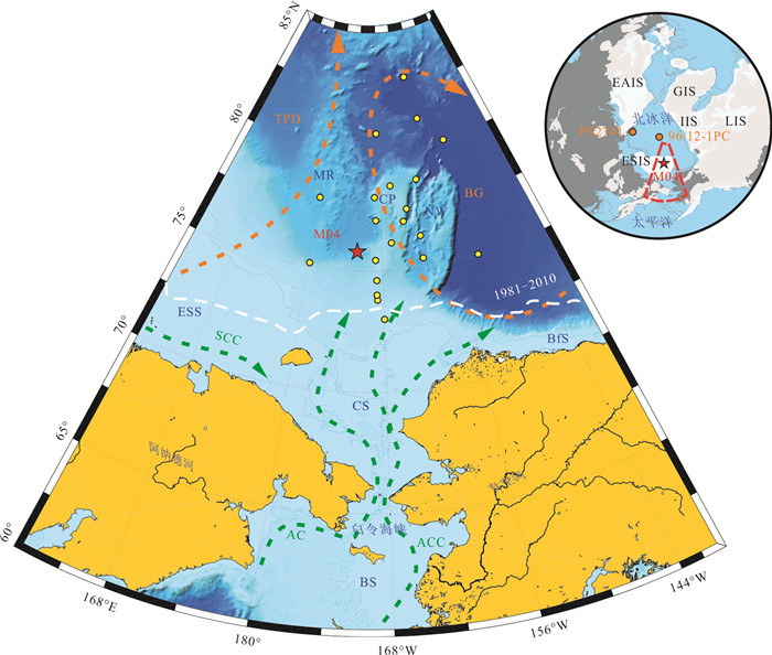
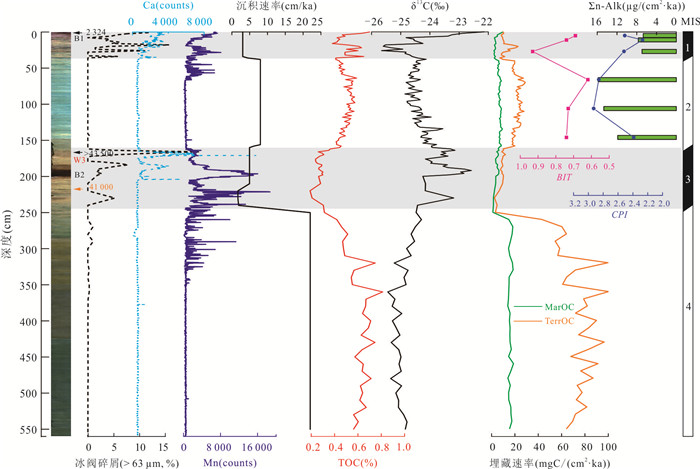
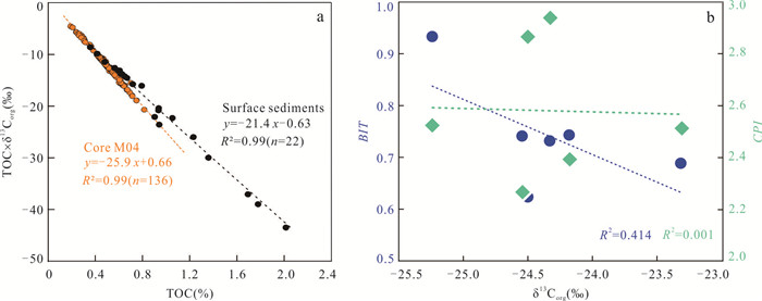
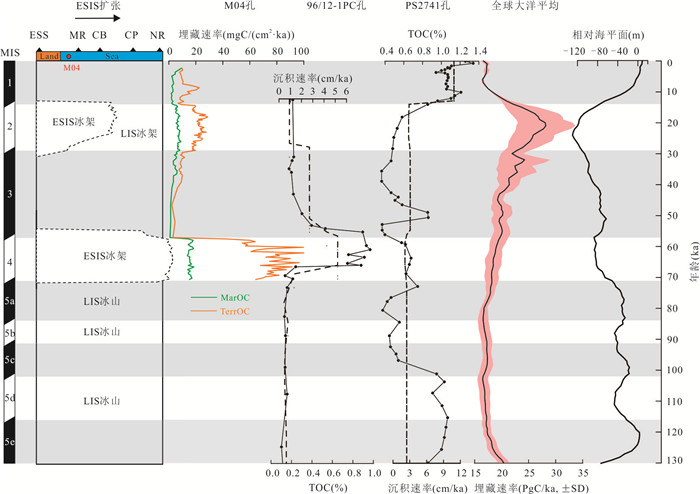
The burial of particulate organic carbon is a critical factor in assessing the Arctic Ocean's carbon sequestration capacity, but its burial characteristics on orbital timescales remain highly debated. This study further explores the composition, source, and burial rate of organic matter in the Late Pleistocene and its co-evolution with the surrounding ice sheet by analyzing indicators such as total organic carbon, stable isotopes, and biomarkers in Core M04 at the Chukchi continental margin and the surrounding surface sediments. Results show that terrestrial organic carbon is the primary component of organic carbon burial at the Chukchi continental margin, with significant differences observed over glacial-interglacial cycles, with a low burial rate during the interglacial periods (MIS1 and MIS3) and a sharp increase in burial rate during the glacial periods (MIS4 and MIS2). Combined with the geomorphic features and depositional environment, the expansion of the East Siberian ice sheet (ESIS) and the transport of subglacial drainage systems may be the main controlling factors for the secondary transport of shelf organic carbon and its rapid burial at the continental margin. M04's records provide a new perspective to unravel the characteristics of organic carbon burial, further revealing the mechanisms in the high-sedimentation-rate area of the Arctic Ocean, and help to objectively evaluate the role of Arctic Ocean carbon burial in promoting global carbon sequestration. However, further research, especially records from Arctic Canada, is needed to fully describe the coupling relationship between Arctic Ocean carbon burial and climate transition.
The burial of particulate organic carbon is a critical factor in assessing the Arctic Ocean's carbon sequestration capacity, but its burial characteristics on orbital timescales remain highly debated. This study further explores the composition, source, and burial rate of organic matter in the Late Pleistocene and its co-evolution with the surrounding ice sheet by analyzing indicators such as total organic carbon, stable isotopes, and biomarkers in Core M04 at the Chukchi continental margin and the surrounding surface sediments. Results show that terrestrial organic carbon is the primary component of organic carbon burial at the Chukchi continental margin, with significant differences observed over glacial-interglacial cycles, with a low burial rate during the interglacial periods (MIS1 and MIS3) and a sharp increase in burial rate during the glacial periods (MIS4 and MIS2). Combined with the geomorphic features and depositional environment, the expansion of the East Siberian ice sheet (ESIS) and the transport of subglacial drainage systems may be the main controlling factors for the secondary transport of shelf organic carbon and its rapid burial at the continental margin. M04's records provide a new perspective to unravel the characteristics of organic carbon burial, further revealing the mechanisms in the high-sedimentation-rate area of the Arctic Ocean, and help to objectively evaluate the role of Arctic Ocean carbon burial in promoting global carbon sequestration. However, further research, especially records from Arctic Canada, is needed to fully describe the coupling relationship between Arctic Ocean carbon burial and climate transition.
2024, 49(9): 3399-3410.
doi: 10.3799/dqkx.2023.161
Abstract:
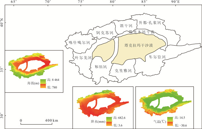
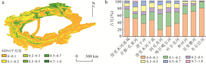
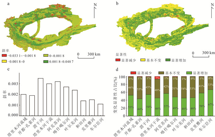
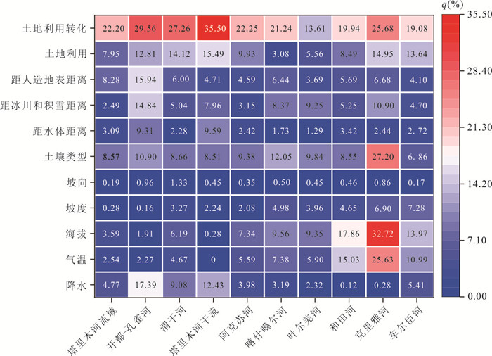
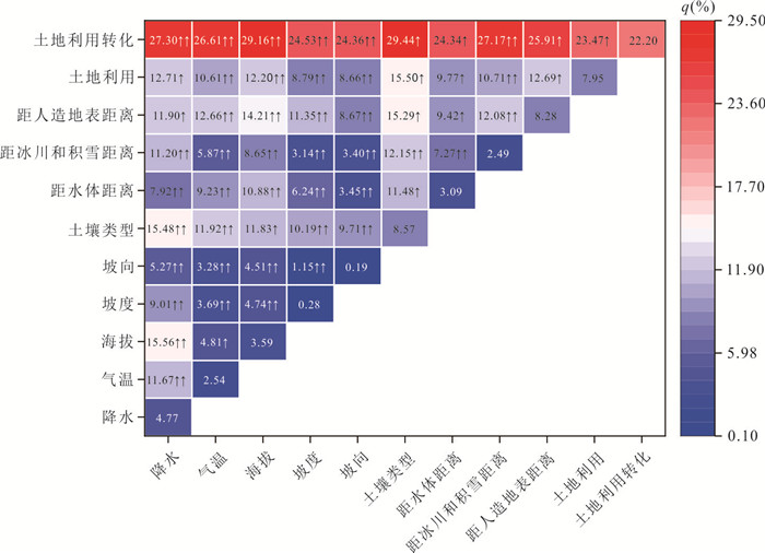
Given the extreme aridity of the Tarim River basin, it is critical to explore the characteristics of vegetation dynamics in the region and to quantitatively evaluate the strength of potential drivers to maintain ecosystem function and achieve sustainable development. The spatial and temporal trends and spatial autocorrelation of vegetation cover in the Tarim River basin from 2000 to 2020 are explored, based on long time series NDVI datasets, climate data, background data and land use data, and the strength of potential driving factors on NDVI changes is quantitatively assessed, using geographical detector. It is found that the average NDVI from 2000 to 2020 was 0.159, and 52.63% of the area showed a significant growth trend with a growth rate of 0.02/10a, and the global Moran's index of NDVI showed a fluctuating upward trend and exhibited a spatial agglomeration. Land use conversion, soil type, and distance from the man-made surface were the main driving factors of vegetation change in the Tarim River basin, with explanatory power of 22.20%, 8.57%, and 8.28% for NDVI change, respectively. Precipitation is the dominant climatic factor in the northern part of the Tarim River basin, temperature has a stronger explanatory power for NDVI changes in the west and south, and distance to glaciers and snow is a factor affecting NDVI changes that cannot be ignored. The interaction of any two factors can improve the explanatory power of NDVI changes, among which the strongest explanatory power is found in land use conversion ∩ soil type (q=29.44%) at the watershed scale, while there are differences in the combination and intensity of the strongest explanatory interactions at the sub-basin scale. The results help to improve the understanding of NDVI change mechanisms in the Tarim River basin and provide a scientific basis for ecological conservation in arid and semi-arid regions.
Given the extreme aridity of the Tarim River basin, it is critical to explore the characteristics of vegetation dynamics in the region and to quantitatively evaluate the strength of potential drivers to maintain ecosystem function and achieve sustainable development. The spatial and temporal trends and spatial autocorrelation of vegetation cover in the Tarim River basin from 2000 to 2020 are explored, based on long time series NDVI datasets, climate data, background data and land use data, and the strength of potential driving factors on NDVI changes is quantitatively assessed, using geographical detector. It is found that the average NDVI from 2000 to 2020 was 0.159, and 52.63% of the area showed a significant growth trend with a growth rate of 0.02/10a, and the global Moran's index of NDVI showed a fluctuating upward trend and exhibited a spatial agglomeration. Land use conversion, soil type, and distance from the man-made surface were the main driving factors of vegetation change in the Tarim River basin, with explanatory power of 22.20%, 8.57%, and 8.28% for NDVI change, respectively. Precipitation is the dominant climatic factor in the northern part of the Tarim River basin, temperature has a stronger explanatory power for NDVI changes in the west and south, and distance to glaciers and snow is a factor affecting NDVI changes that cannot be ignored. The interaction of any two factors can improve the explanatory power of NDVI changes, among which the strongest explanatory power is found in land use conversion ∩ soil type (q=29.44%) at the watershed scale, while there are differences in the combination and intensity of the strongest explanatory interactions at the sub-basin scale. The results help to improve the understanding of NDVI change mechanisms in the Tarim River basin and provide a scientific basis for ecological conservation in arid and semi-arid regions.

2024, 49(9): 3411-3427.
doi: 10.3799/dqkx.2023.158
Abstract:
The sedimentary tectonic background of the southeastern part of South China Block (SCB) remains controversial. This study focuses on the set of NE-SW stretching clastic sedimentary with alternating lithology of sand and slate with regional gravel interbeds, conducting the sedimentary strata correlation and detrital zircon U-Pb ages in order to constrain the sedimentary tectonic background. Four Nanhuan-Sinian sedimentary strata sections have been studied and the results show that Nanhuan-Sinian sedimentary of the southeastern part of SCB could be well correlated and provenance with detrital zircon age peak of 900-1 100 Ma migrated from southeast to northwest from the Early Nanhuan to Sinian. "Cathaysia-derived Clastic Strata" are identified according to the lithology and provenance features. The results challenge the opinions that there had been a wide ocean between the blocks of Yangtze and Cathaysia during Nanhuan-Sinian to the west of Zhenghe-Dapu Fault in study area.
The sedimentary tectonic background of the southeastern part of South China Block (SCB) remains controversial. This study focuses on the set of NE-SW stretching clastic sedimentary with alternating lithology of sand and slate with regional gravel interbeds, conducting the sedimentary strata correlation and detrital zircon U-Pb ages in order to constrain the sedimentary tectonic background. Four Nanhuan-Sinian sedimentary strata sections have been studied and the results show that Nanhuan-Sinian sedimentary of the southeastern part of SCB could be well correlated and provenance with detrital zircon age peak of 900-1 100 Ma migrated from southeast to northwest from the Early Nanhuan to Sinian. "Cathaysia-derived Clastic Strata" are identified according to the lithology and provenance features. The results challenge the opinions that there had been a wide ocean between the blocks of Yangtze and Cathaysia during Nanhuan-Sinian to the west of Zhenghe-Dapu Fault in study area.
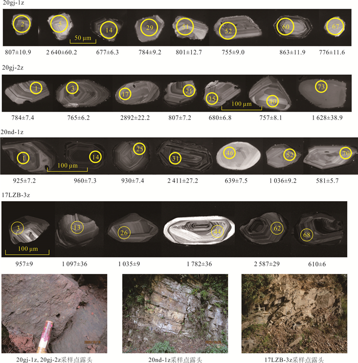
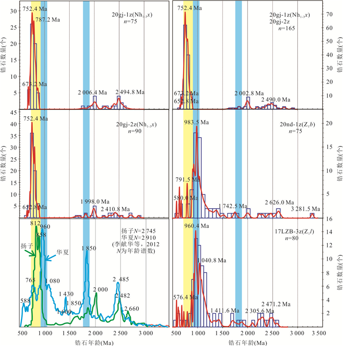
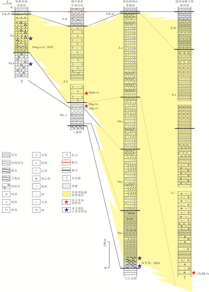
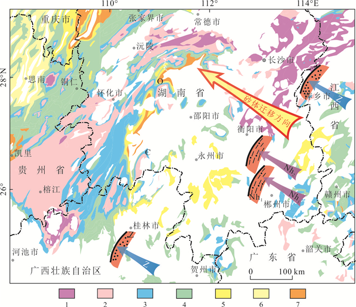
2024, 49(9): 3428-3439.
doi: 10.3799/dqkx.2022.189
Abstract:
Groundwater with high As concentration often contains high NH4+ components,but few studies have been conducted to investigate the effect of nitrogen cycling on the migration and release of As. The aquifer system in Jianghan Plain contains high arsenic as well as high content of ammonium in groundwater. The purpose of this study is to explore the effect of nitrogen reactive transport on the As release. In this study,the different water bodies in Jianghan Plain were sampled and their hydrochemical and isotopic indexes were tested,and hierarchical cluster analysis was performed on the sampling sites using the physicochemical indexes related to nitrogen and arsenic. The results show that along the direction of groundwater flow,due to the changes of groundwater redox conditions,the effect of nitrogen redox process on arsenic release process is different. Near the groundwater recharge area,the enrichment of NO3‒ in the relatively oxidized zone inhibits the dissolution of iron oxide. Along the groundwater flow path,the redox environment of aquifer system changes from oxidized to reduced condition. The enhanced denitrification occurring in the reduced environment could promote the dissolution of iron oxide,resulting in the release of As into groundwater. The denitrification is further enhanced in the groundwater discharge zone,and denitrification and DNRA using Fe2+ as electron donor may influence arsenic release.
Groundwater with high As concentration often contains high NH4+ components,but few studies have been conducted to investigate the effect of nitrogen cycling on the migration and release of As. The aquifer system in Jianghan Plain contains high arsenic as well as high content of ammonium in groundwater. The purpose of this study is to explore the effect of nitrogen reactive transport on the As release. In this study,the different water bodies in Jianghan Plain were sampled and their hydrochemical and isotopic indexes were tested,and hierarchical cluster analysis was performed on the sampling sites using the physicochemical indexes related to nitrogen and arsenic. The results show that along the direction of groundwater flow,due to the changes of groundwater redox conditions,the effect of nitrogen redox process on arsenic release process is different. Near the groundwater recharge area,the enrichment of NO3‒ in the relatively oxidized zone inhibits the dissolution of iron oxide. Along the groundwater flow path,the redox environment of aquifer system changes from oxidized to reduced condition. The enhanced denitrification occurring in the reduced environment could promote the dissolution of iron oxide,resulting in the release of As into groundwater. The denitrification is further enhanced in the groundwater discharge zone,and denitrification and DNRA using Fe2+ as electron donor may influence arsenic release.