2025 Vol. 50, No. 1
Display Method:
2025, 50(1): 1-18.
doi: 10.3799/dqkx.2024.137
 PDF 4031KB
Abstract:
Due to the coupled effects of the properties of minerals and the advantages offered by composite materials, mineral-based composite materials have exhibited unique performances and attracted significant attention in the field of eco-environmental studies with extensive applications in improving water quality. This paper reviews various methods for enhancing the structure and properties of mineral-based composites materials, including acid/alkali etching, thermal activation modification, surface modification, and metal nanoparticle load modification. The mechanisms of these materials in effectively fixing/removing heavy metals, organic and inorganic pollutants in the aquatic environmental pollutants include adsorption, catalytic reactions, and synergistic effects with aquatic organisms such as microorganisms and aquatic plants. Mineral-based composite material plays a vital role in advancing biological ecological restoration, promoting the growth of aquatic plants, and enhancing microbial diversity. And the paper summarizes application cases of mineral-based composite materials in water environment restoration and management, and emphasizes the focus of future research on assessing their performance and long-term effects in different water quality environments, exploring best approaches of their joint application with other advanced techniques, and optimizing their manufacturing processes and material costs.
Due to the coupled effects of the properties of minerals and the advantages offered by composite materials, mineral-based composite materials have exhibited unique performances and attracted significant attention in the field of eco-environmental studies with extensive applications in improving water quality. This paper reviews various methods for enhancing the structure and properties of mineral-based composites materials, including acid/alkali etching, thermal activation modification, surface modification, and metal nanoparticle load modification. The mechanisms of these materials in effectively fixing/removing heavy metals, organic and inorganic pollutants in the aquatic environmental pollutants include adsorption, catalytic reactions, and synergistic effects with aquatic organisms such as microorganisms and aquatic plants. Mineral-based composite material plays a vital role in advancing biological ecological restoration, promoting the growth of aquatic plants, and enhancing microbial diversity. And the paper summarizes application cases of mineral-based composite materials in water environment restoration and management, and emphasizes the focus of future research on assessing their performance and long-term effects in different water quality environments, exploring best approaches of their joint application with other advanced techniques, and optimizing their manufacturing processes and material costs.
2025, 50(1): 19-32.
doi: 10.3799/dqkx.2024.020
Abstract:
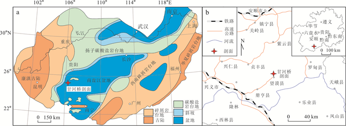
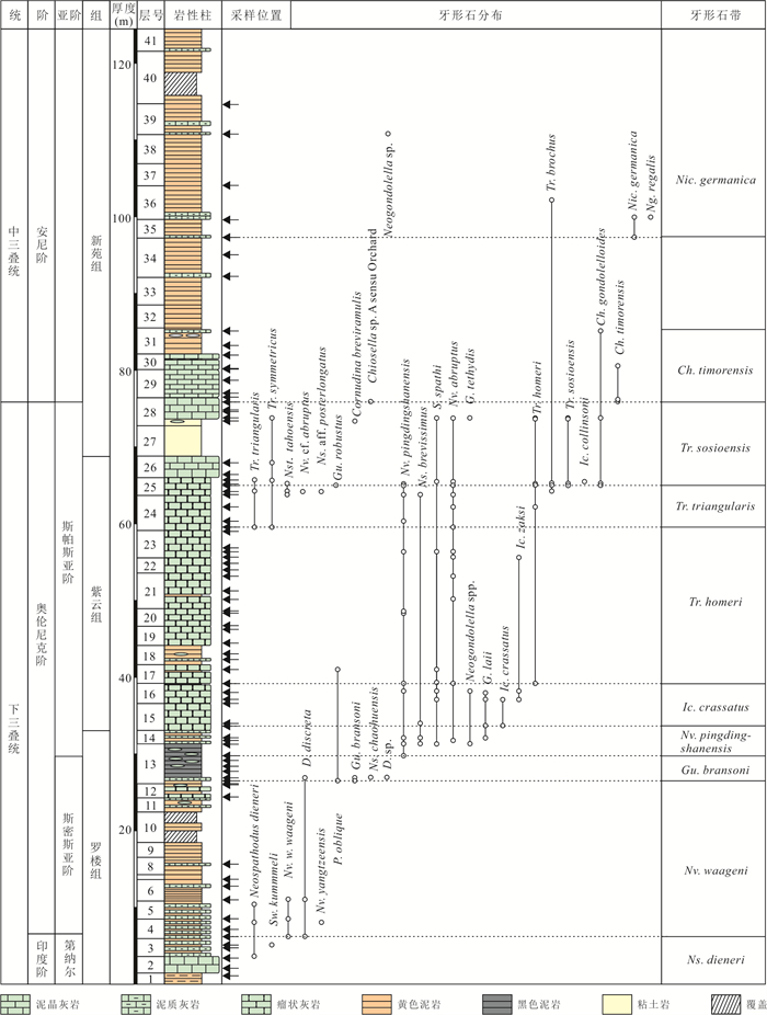
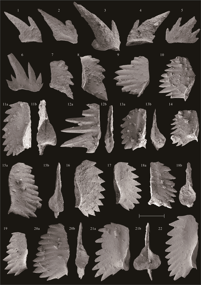
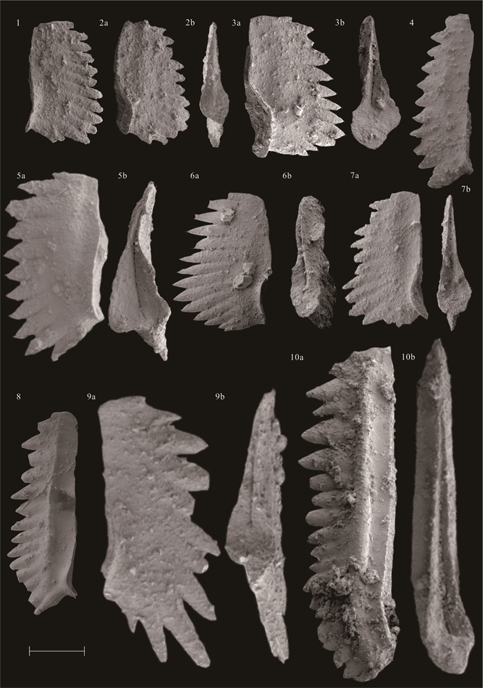
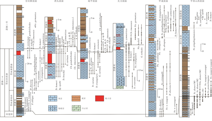
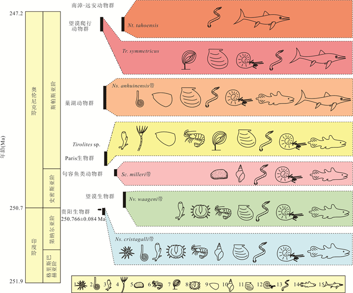
The establishment of modern ecosystem in Early Triassic is challenging and subject to frequent fluctuation of environment, thus a refined time scale is demanded to explore its process and mechanism. Although conodonts are often used as index fossils in the correlation and division of Paleozoic and Early Mesozoic marine strata, the international classification and comparison criteria for multiple stages and substages of the Early-Middle Triassic have been pending. Some candidate index fossils have yet to be further tested by regional and global correlation. The deep-water strata were well developed in the Lower-Middle Triassic at the Ganheqiao Section in Wangmo County of Guizhou. In this paper, a systematic study of conodont taxonomy and stratigraphy was carried out on the samples near the Lower-Middle Triassic boundaries of the section. A total of 29 species in 15 genera were identified and 10 conodont zones were recognized, namely Neospathodus dieneri Zone, Novispathodus waageni Zone, Guangxidella bransoni Zone, Novispathodus pingdingshanensis Zone, Icriospathodus crassatus Zone, Triassospthodus homeri Zone, Triassospthodus triangularis Zone, Triassospthodus sosioensis Zone, Chiosella timorensis Zone, Nicoraella germanica Zone in ascending order. According to the distribution of conodonts in this section and the comparison with other sections, it is supported that the first occurrences of conodonts Novispathodus waageni, Novispathodus pingdingshanensis and Chiosella timorensis are used as the criteria for the Indian-Olenekian, Smithian-Spathian and Lower-Middle Triassic boundaries, respectively. In the past few years, multiple layers of marine reptiles and diverse arthropod fossils have been reported in the Triassic in the Wangmo area, indicating a multi-stage evolution of marine ecosystems. The high-resolution biostratigraphic framework established in this paper provides key evidence to calibrate the build-up time of modern marine ecosystems in study area.
The establishment of modern ecosystem in Early Triassic is challenging and subject to frequent fluctuation of environment, thus a refined time scale is demanded to explore its process and mechanism. Although conodonts are often used as index fossils in the correlation and division of Paleozoic and Early Mesozoic marine strata, the international classification and comparison criteria for multiple stages and substages of the Early-Middle Triassic have been pending. Some candidate index fossils have yet to be further tested by regional and global correlation. The deep-water strata were well developed in the Lower-Middle Triassic at the Ganheqiao Section in Wangmo County of Guizhou. In this paper, a systematic study of conodont taxonomy and stratigraphy was carried out on the samples near the Lower-Middle Triassic boundaries of the section. A total of 29 species in 15 genera were identified and 10 conodont zones were recognized, namely Neospathodus dieneri Zone, Novispathodus waageni Zone, Guangxidella bransoni Zone, Novispathodus pingdingshanensis Zone, Icriospathodus crassatus Zone, Triassospthodus homeri Zone, Triassospthodus triangularis Zone, Triassospthodus sosioensis Zone, Chiosella timorensis Zone, Nicoraella germanica Zone in ascending order. According to the distribution of conodonts in this section and the comparison with other sections, it is supported that the first occurrences of conodonts Novispathodus waageni, Novispathodus pingdingshanensis and Chiosella timorensis are used as the criteria for the Indian-Olenekian, Smithian-Spathian and Lower-Middle Triassic boundaries, respectively. In the past few years, multiple layers of marine reptiles and diverse arthropod fossils have been reported in the Triassic in the Wangmo area, indicating a multi-stage evolution of marine ecosystems. The high-resolution biostratigraphic framework established in this paper provides key evidence to calibrate the build-up time of modern marine ecosystems in study area.
2025, 50(1): 33-45.
doi: 10.3799/dqkx.2024.047
Abstract:
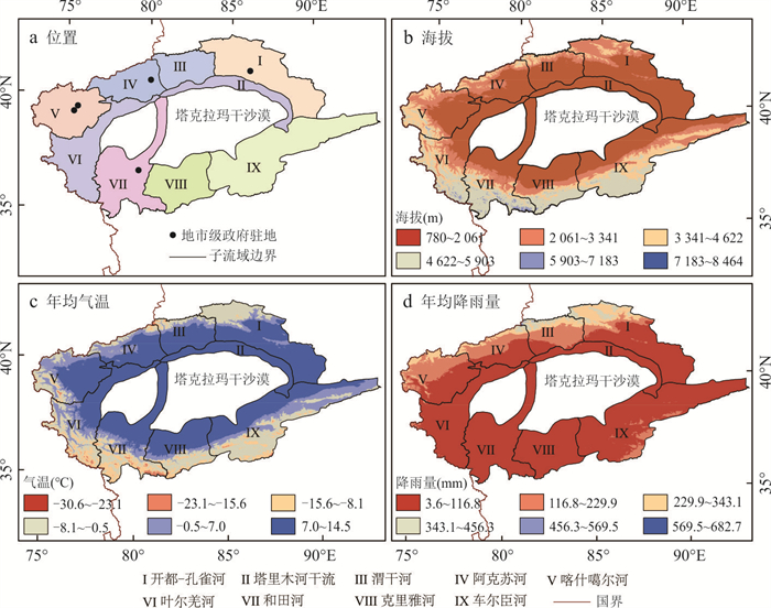
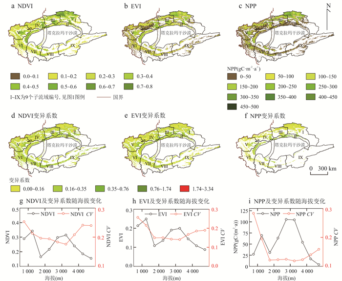
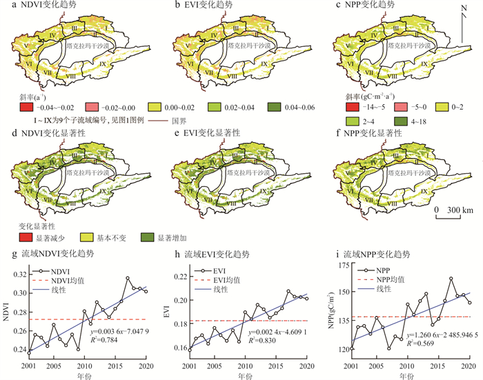
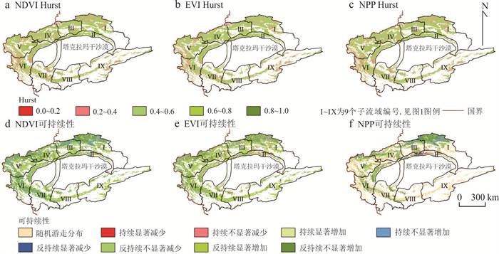
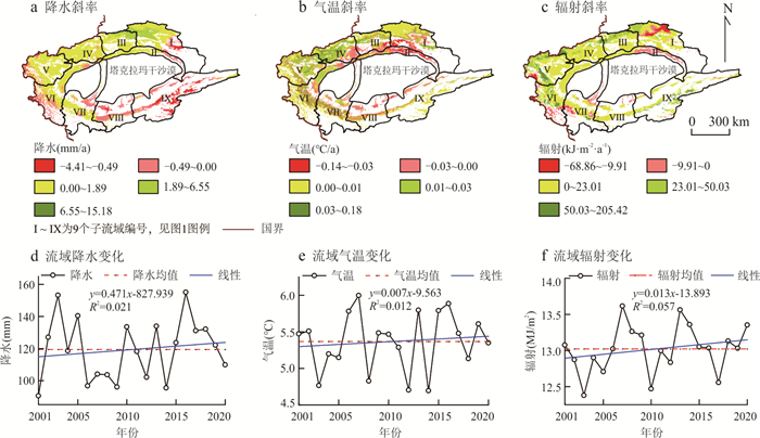
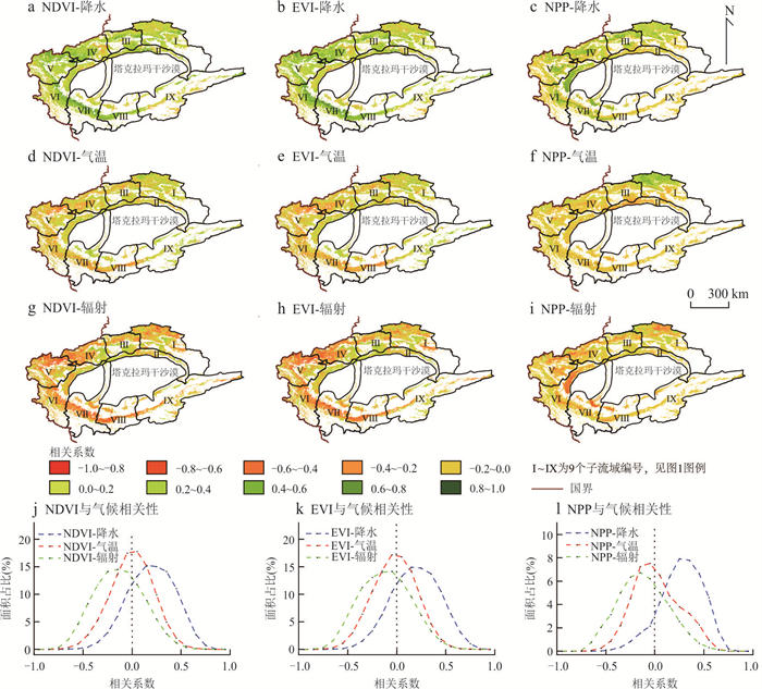
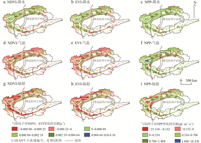
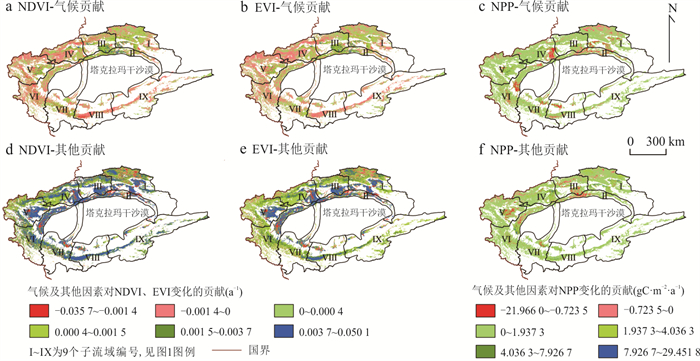
To understand the role of climatic factors in driving vegetation changes in the Tarim River Basin during the "warming and humidification" process in Northwest China, based on the linear regression, coefficient of variation, Person correlation coefficient, Hurst index and partial derivative methods, the climate-driven mechanism of vegetation change in the Tarim River Basin was quantitatively evaluated using MODIS satellite remote sensing data and meteorological data. It is found that the optimal vegetation growth and productivity levels in the basin showed a fluctuating upward trend, and the index NDVI, EVI, and NPP growth rates were 0.036 4/10a, 0.023 8/10a, and 12.606 1 gC/(m2∙10a), respectively. The Hurst index shows that the study area had the problem of uncertainty of continuous change in vegetation, and the areas of continuous improvement accounted for 19.7%, 18.7%, and 6.1% of the watershed area, respectively. At the watershed scale, the contributions of climatic factors to NDVI, EVI, and NPP were 0.001 6/10a, 0.001 0/10a, and 2.801 9 gC/(m2∙10a), respectively. Precipitation was the main climatic factor affecting vegetation change compared to air temperature; radiation had an inhibitory effect on vegetation change. Climate change contributed limitedly to the changes in optimal vegetation growth, but promoted significant improvements in vegetation productivity. The results reveal the spatial characteristics of vegetation change and climate-driven changes in the Tarim River Basin.
To understand the role of climatic factors in driving vegetation changes in the Tarim River Basin during the "warming and humidification" process in Northwest China, based on the linear regression, coefficient of variation, Person correlation coefficient, Hurst index and partial derivative methods, the climate-driven mechanism of vegetation change in the Tarim River Basin was quantitatively evaluated using MODIS satellite remote sensing data and meteorological data. It is found that the optimal vegetation growth and productivity levels in the basin showed a fluctuating upward trend, and the index NDVI, EVI, and NPP growth rates were 0.036 4/10a, 0.023 8/10a, and 12.606 1 gC/(m2∙10a), respectively. The Hurst index shows that the study area had the problem of uncertainty of continuous change in vegetation, and the areas of continuous improvement accounted for 19.7%, 18.7%, and 6.1% of the watershed area, respectively. At the watershed scale, the contributions of climatic factors to NDVI, EVI, and NPP were 0.001 6/10a, 0.001 0/10a, and 2.801 9 gC/(m2∙10a), respectively. Precipitation was the main climatic factor affecting vegetation change compared to air temperature; radiation had an inhibitory effect on vegetation change. Climate change contributed limitedly to the changes in optimal vegetation growth, but promoted significant improvements in vegetation productivity. The results reveal the spatial characteristics of vegetation change and climate-driven changes in the Tarim River Basin.
2025, 50(1): 46-57.
doi: 10.3799/dqkx.2024.078
Abstract:
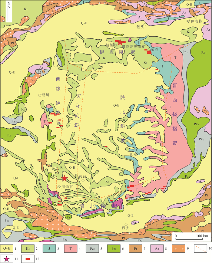
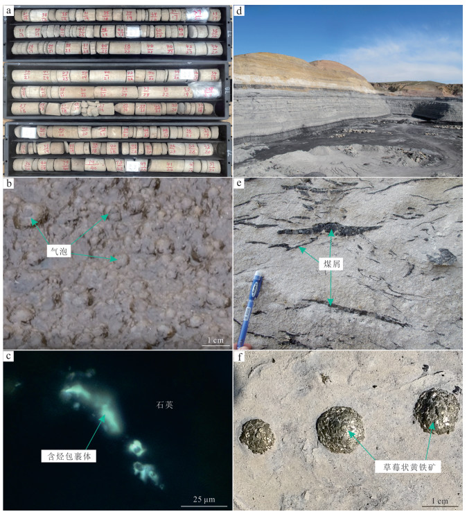
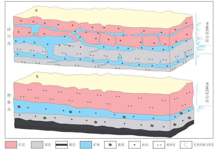
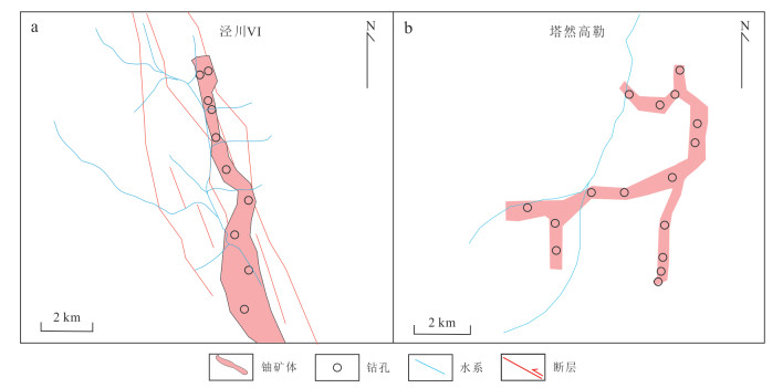
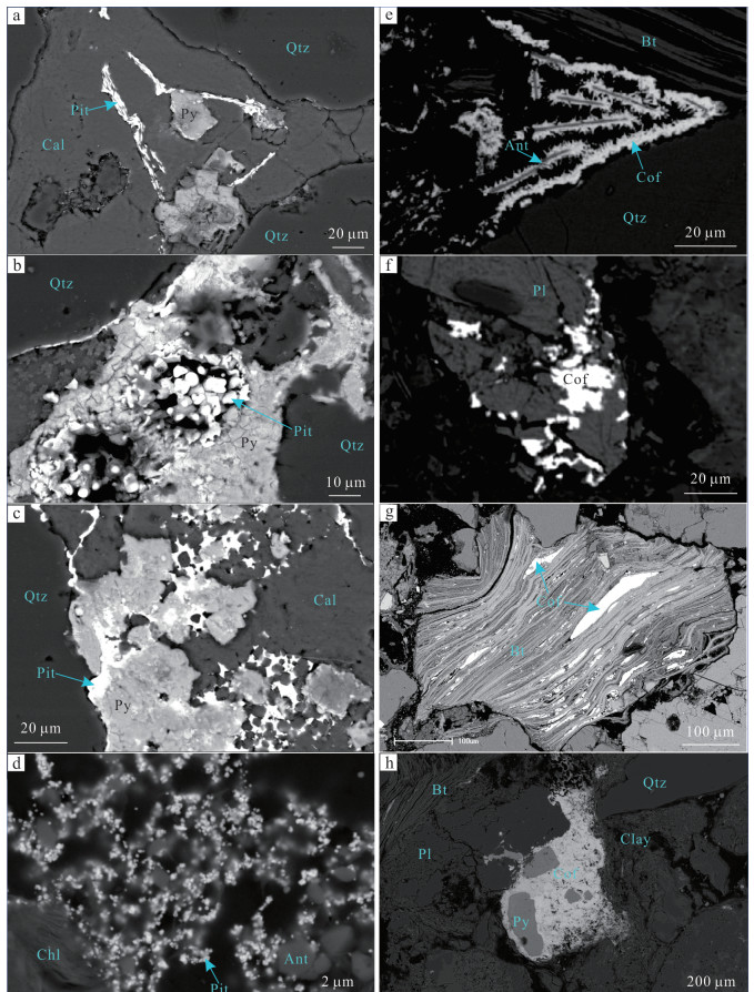
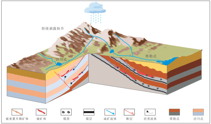
The existing ore-forming models related to sedimentary-hosted uranium deposits have been primarily established focusing on different ore-controlling factors such as tectonics, sedimentation, and fluids. These models are diverse and complex. Over the past decades, with the comprehensive development of secondary exploration for uranium in drilling data from coalfields and oilfields, the close spatial coexistence pattern of "coal-oil-uranium" has been rapidly revealed. This paper analyzes the reducing media that constrain the enrichment of sedimentary-hosted uranium deposits from different perspectives. By systematically comparing and analyzing the ore-forming conditions, mineral characteristics, and geochemical features of the super large uranium deposits in the Jingchuan oil and gas field and the Tale coalfield in the Ordos Basin, two uranium ore-forming models, namely the Jingchuan type and the Tale type, are established. The Jingchuan type reducing media are primarily hydrocarbon fluids (such as CH4, H2, CO, as well as secondary H2S, pyrite, etc.), which are mainly derived from the expulsion and migration of deep-seated hydrocarbon source rocks after the sedimentary diagenesis period to the Lower Cretaceous Luohe Formation, coupled with the ore-forming process of surface oxygenated and uranium-bearing fluids. The ore bodies in this model are notably controlled by factors such as reservoir permeability, late-stage fault structures, and hydrological distribution, often characterized by the presence of multiple mineralized layers, typically dozens or even scores of layers. Constrained by the migration range of oil and gas, they exhibit significant lateral variations and phenomena of ore bodies cutting across bedding planes. The uranium minerals are primarily asphaltic uranium ores, appearing as emulsion texture, angular texture, vein-like texture, with relatively small grains ranging from a few to tens of micrometers, occasionally reaching several tens of micrometers, and distributed relatively evenly, accompanied by minerals such as pyrite, quartz, calcite, and rutile. In contrast, the Tale type reducing media are mainly coal debris, deposited contemporaneously during the sedimentary diagenesis period, and are produced parallel to the bedding, serving as chemical barriers for the enrichment and precipitation of uranium in surface oxidizing and uranium-bearing fluids. The ore bodies in this model are subject to dual constraints from the occurrence of coal-bearing rock layers and hydrology, generally exhibiting relatively stable lateral distribution. The mineralized layers usually consist of 2 to 3 layers, with the ore layers being essentially consistent with the coal-bearing rock layers, and phenomena of cutting across bedding planes are not evident. The uranium minerals mainly include uraninite and coffinite, showing irregularly granular texture, blocky texture, vein-like texture, feather-like texture, with significant variations in particle size ranging from a few micrometers to several hundred micrometers, unevenly distributed, and accompanied by minerals such as pyrite, mica, rutile, coal debris, quartz, and calcite. These two uranium ore-forming models exhibit significant differences in ore-forming conditions and characteristics, providing not only theoretical basis for uranium exploration, but also new directions for the response of multi-energy mineralization in basins and the study of the mechanisms of the sedimentary-hosted uranium.
The existing ore-forming models related to sedimentary-hosted uranium deposits have been primarily established focusing on different ore-controlling factors such as tectonics, sedimentation, and fluids. These models are diverse and complex. Over the past decades, with the comprehensive development of secondary exploration for uranium in drilling data from coalfields and oilfields, the close spatial coexistence pattern of "coal-oil-uranium" has been rapidly revealed. This paper analyzes the reducing media that constrain the enrichment of sedimentary-hosted uranium deposits from different perspectives. By systematically comparing and analyzing the ore-forming conditions, mineral characteristics, and geochemical features of the super large uranium deposits in the Jingchuan oil and gas field and the Tale coalfield in the Ordos Basin, two uranium ore-forming models, namely the Jingchuan type and the Tale type, are established. The Jingchuan type reducing media are primarily hydrocarbon fluids (such as CH4, H2, CO, as well as secondary H2S, pyrite, etc.), which are mainly derived from the expulsion and migration of deep-seated hydrocarbon source rocks after the sedimentary diagenesis period to the Lower Cretaceous Luohe Formation, coupled with the ore-forming process of surface oxygenated and uranium-bearing fluids. The ore bodies in this model are notably controlled by factors such as reservoir permeability, late-stage fault structures, and hydrological distribution, often characterized by the presence of multiple mineralized layers, typically dozens or even scores of layers. Constrained by the migration range of oil and gas, they exhibit significant lateral variations and phenomena of ore bodies cutting across bedding planes. The uranium minerals are primarily asphaltic uranium ores, appearing as emulsion texture, angular texture, vein-like texture, with relatively small grains ranging from a few to tens of micrometers, occasionally reaching several tens of micrometers, and distributed relatively evenly, accompanied by minerals such as pyrite, quartz, calcite, and rutile. In contrast, the Tale type reducing media are mainly coal debris, deposited contemporaneously during the sedimentary diagenesis period, and are produced parallel to the bedding, serving as chemical barriers for the enrichment and precipitation of uranium in surface oxidizing and uranium-bearing fluids. The ore bodies in this model are subject to dual constraints from the occurrence of coal-bearing rock layers and hydrology, generally exhibiting relatively stable lateral distribution. The mineralized layers usually consist of 2 to 3 layers, with the ore layers being essentially consistent with the coal-bearing rock layers, and phenomena of cutting across bedding planes are not evident. The uranium minerals mainly include uraninite and coffinite, showing irregularly granular texture, blocky texture, vein-like texture, feather-like texture, with significant variations in particle size ranging from a few micrometers to several hundred micrometers, unevenly distributed, and accompanied by minerals such as pyrite, mica, rutile, coal debris, quartz, and calcite. These two uranium ore-forming models exhibit significant differences in ore-forming conditions and characteristics, providing not only theoretical basis for uranium exploration, but also new directions for the response of multi-energy mineralization in basins and the study of the mechanisms of the sedimentary-hosted uranium.
2025, 50(1): 58-76.
doi: 10.3799/dqkx.2024.008
Abstract:
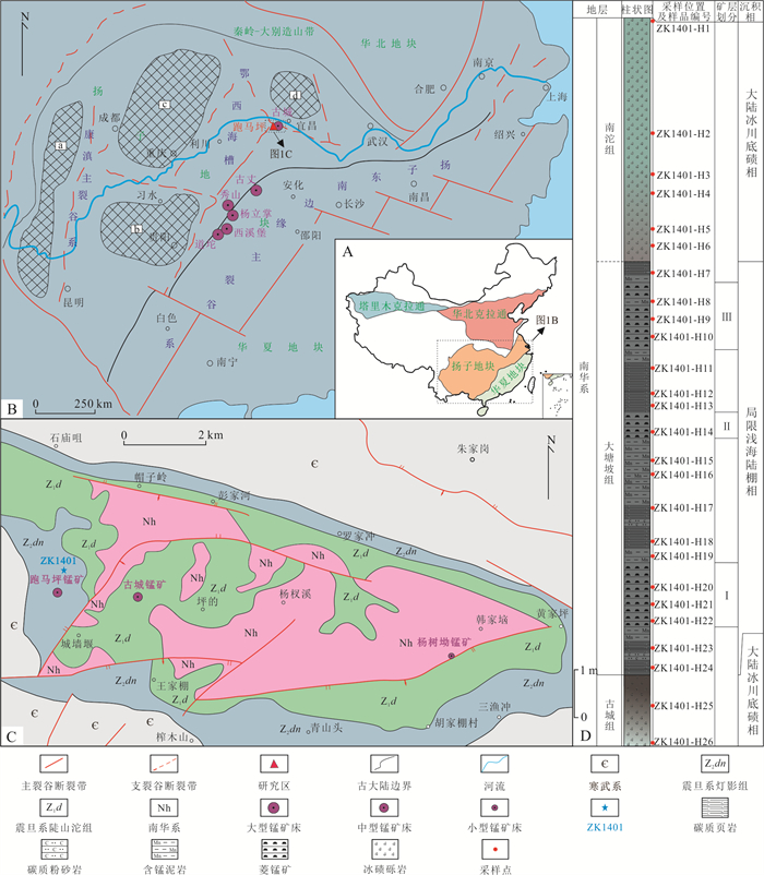
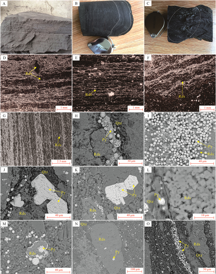
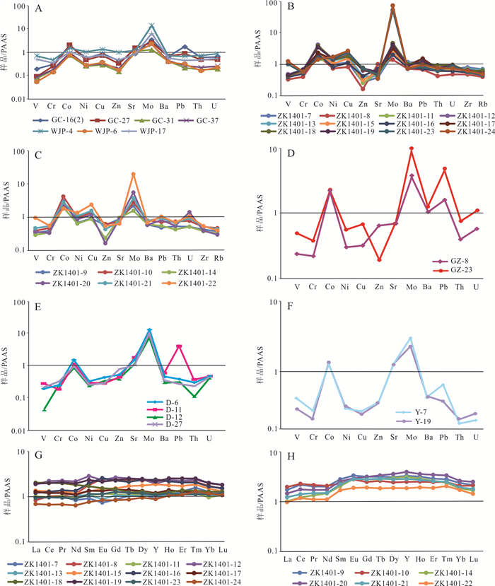
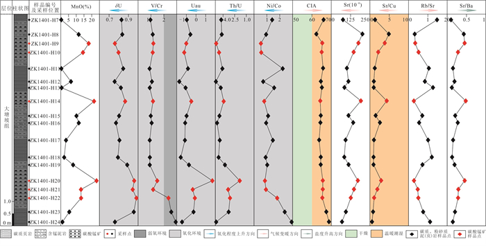
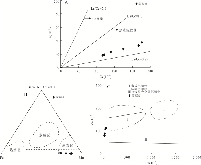
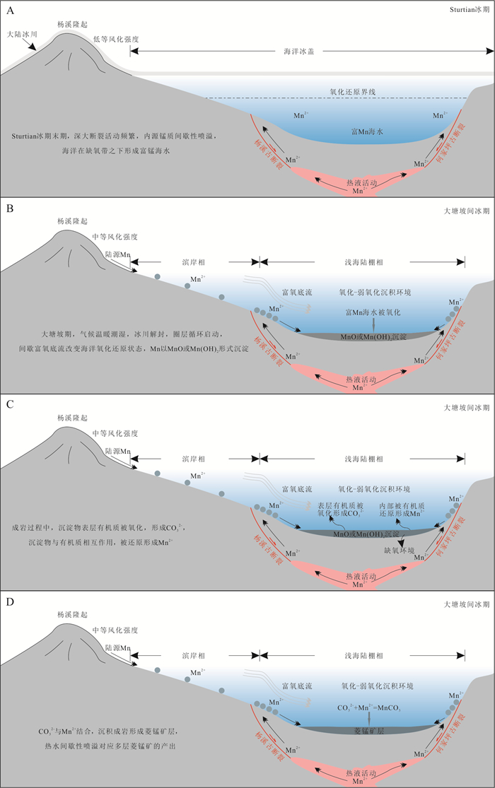
The Nanhua manganese deposit in Changyang anticline of western Hubei is a Datangpo-type manganese deposit, and its metallogenic age is precisely in the interglacial period of the Neoproterozoic Snowball Earth event.Under the background of the breakup of the Rodinia supercontinent, there is genetic relationship among the climate change, rift basin and manganese mineralization in the Datangpo period. In order to elaborate the control of paleoclimate, sedimentary environment and manganese source on the sedimentary mineralization of large-scale manganese deposits, restore the metallogenic process of Datangpo-type manganese deposits in western Hubei, this study selected Paomaping manganese deposit in Changyang area of western Hubei as the research object, and carried out a comprehensive study on its geochemical characteristics.The results show that the Mn/Fe ratio of manganese carbonate ore is high, the separation of Mn and Fe was very thorough during the deposition process, the oxidation-reduction sensitive elements V and U are depleted, and Mo is enriched, revealing that the Datangpo period is an oxidation-weak oxidation sedimentary environment. Paleo-oxygenation facies such as δU, Uau, Th/U, V/Cr, and Co/Ni indicate that the Datangpo period was an oxygen and weak oxidation sedimentary environment. The Al and Ti contents of the Changyang anticline rhodochrosite are slightly higher than those in the Hunan, Guizhou and Chongqing areas, indicating that the content of terrigenous debris in the manganese deposits in the northern margin of Yangtze is higher than that in the southeastern margin of Yangtze and the depth of its sedimentary water is relatively shallow or closer to the source. The study of CIA index shows that the weathering intensity of Datangpo period in Changyang anticline is medium, rhodochrosite and carbonaceous mud (shale) rock are characterized by the low Al/(Al+Mn+Fe)ratios, positive Eu anomalies, LREE enrichment, Nb/Ta, Zr/Hf, Y/Ho ratio and La/Yb-Ce/La, (Co+Ni+Cu)×10-Fe-Mn, Zr-Cr diagram analyses of manganese carbonate indicate that the source of manganese is mainly from deep hydrothermal fluid, supplemented by land-derived manganese, and it was sourced from the hydrothermal sedimentary in the mineralization period. By studying the CIA index, Sr/Cu, Rb/Sr, Sr, Sr/Ba values, it is considered that the Datangpo period of Changyang anticline is a warm and humid climate environment. The mineralization of manganese carbonate is obviously coupled with redox environment, manganese source, paleoclimate and paleosalinity.
The Nanhua manganese deposit in Changyang anticline of western Hubei is a Datangpo-type manganese deposit, and its metallogenic age is precisely in the interglacial period of the Neoproterozoic Snowball Earth event.Under the background of the breakup of the Rodinia supercontinent, there is genetic relationship among the climate change, rift basin and manganese mineralization in the Datangpo period. In order to elaborate the control of paleoclimate, sedimentary environment and manganese source on the sedimentary mineralization of large-scale manganese deposits, restore the metallogenic process of Datangpo-type manganese deposits in western Hubei, this study selected Paomaping manganese deposit in Changyang area of western Hubei as the research object, and carried out a comprehensive study on its geochemical characteristics.The results show that the Mn/Fe ratio of manganese carbonate ore is high, the separation of Mn and Fe was very thorough during the deposition process, the oxidation-reduction sensitive elements V and U are depleted, and Mo is enriched, revealing that the Datangpo period is an oxidation-weak oxidation sedimentary environment. Paleo-oxygenation facies such as δU, Uau, Th/U, V/Cr, and Co/Ni indicate that the Datangpo period was an oxygen and weak oxidation sedimentary environment. The Al and Ti contents of the Changyang anticline rhodochrosite are slightly higher than those in the Hunan, Guizhou and Chongqing areas, indicating that the content of terrigenous debris in the manganese deposits in the northern margin of Yangtze is higher than that in the southeastern margin of Yangtze and the depth of its sedimentary water is relatively shallow or closer to the source. The study of CIA index shows that the weathering intensity of Datangpo period in Changyang anticline is medium, rhodochrosite and carbonaceous mud (shale) rock are characterized by the low Al/(Al+Mn+Fe)ratios, positive Eu anomalies, LREE enrichment, Nb/Ta, Zr/Hf, Y/Ho ratio and La/Yb-Ce/La, (Co+Ni+Cu)×10-Fe-Mn, Zr-Cr diagram analyses of manganese carbonate indicate that the source of manganese is mainly from deep hydrothermal fluid, supplemented by land-derived manganese, and it was sourced from the hydrothermal sedimentary in the mineralization period. By studying the CIA index, Sr/Cu, Rb/Sr, Sr, Sr/Ba values, it is considered that the Datangpo period of Changyang anticline is a warm and humid climate environment. The mineralization of manganese carbonate is obviously coupled with redox environment, manganese source, paleoclimate and paleosalinity.
2025, 50(1): 77-87.
doi: 10.3799/dqkx.2024.021
Abstract:
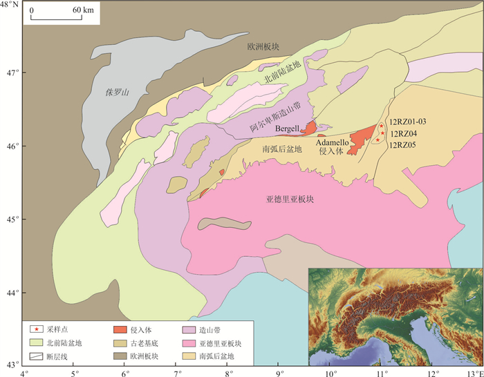
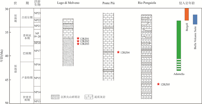
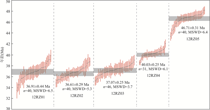
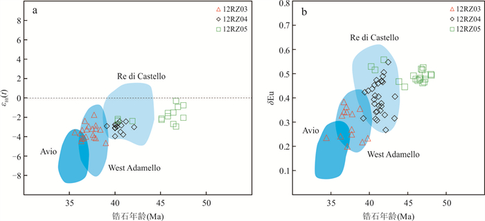
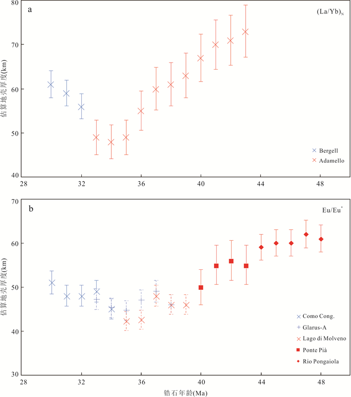
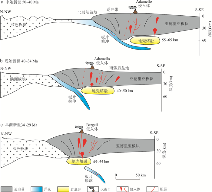
During the Middle Eocene to Early Oligocene, the collision between the European and Adriatic plates led to large-scale magmatic activity in the Alpine orogenic belt, and pyroclastic rocks were recorded in the back arc basin. This study focuses on the geochronology and geochemistry of pyroclastic rocks, and reveals the volcanic activity and structural evolution characteristics of the Alpine orogenic belt. The results indicate that the peak ages of zircons in pyroclastic rocks are mainly concentrated at ~47 Ma, 40 Ma, and 37 Ma. The Hf isotopes of zircons show negative values. It indicates that they were mainly formed in magma with partially melted crust during plate subduction. In addition, the crustal thickness was calculated by using magmatic zircon isotopes. It is demonstrated that the Alpine orogenic belt experienced not only vertical crustal compression thickening caused by plate subduction and collision, but also crustal extension thinning caused by plate stretching.
During the Middle Eocene to Early Oligocene, the collision between the European and Adriatic plates led to large-scale magmatic activity in the Alpine orogenic belt, and pyroclastic rocks were recorded in the back arc basin. This study focuses on the geochronology and geochemistry of pyroclastic rocks, and reveals the volcanic activity and structural evolution characteristics of the Alpine orogenic belt. The results indicate that the peak ages of zircons in pyroclastic rocks are mainly concentrated at ~47 Ma, 40 Ma, and 37 Ma. The Hf isotopes of zircons show negative values. It indicates that they were mainly formed in magma with partially melted crust during plate subduction. In addition, the crustal thickness was calculated by using magmatic zircon isotopes. It is demonstrated that the Alpine orogenic belt experienced not only vertical crustal compression thickening caused by plate subduction and collision, but also crustal extension thinning caused by plate stretching.
2025, 50(1): 88-96.
doi: 10.3799/dqkx.2024.066
Abstract:
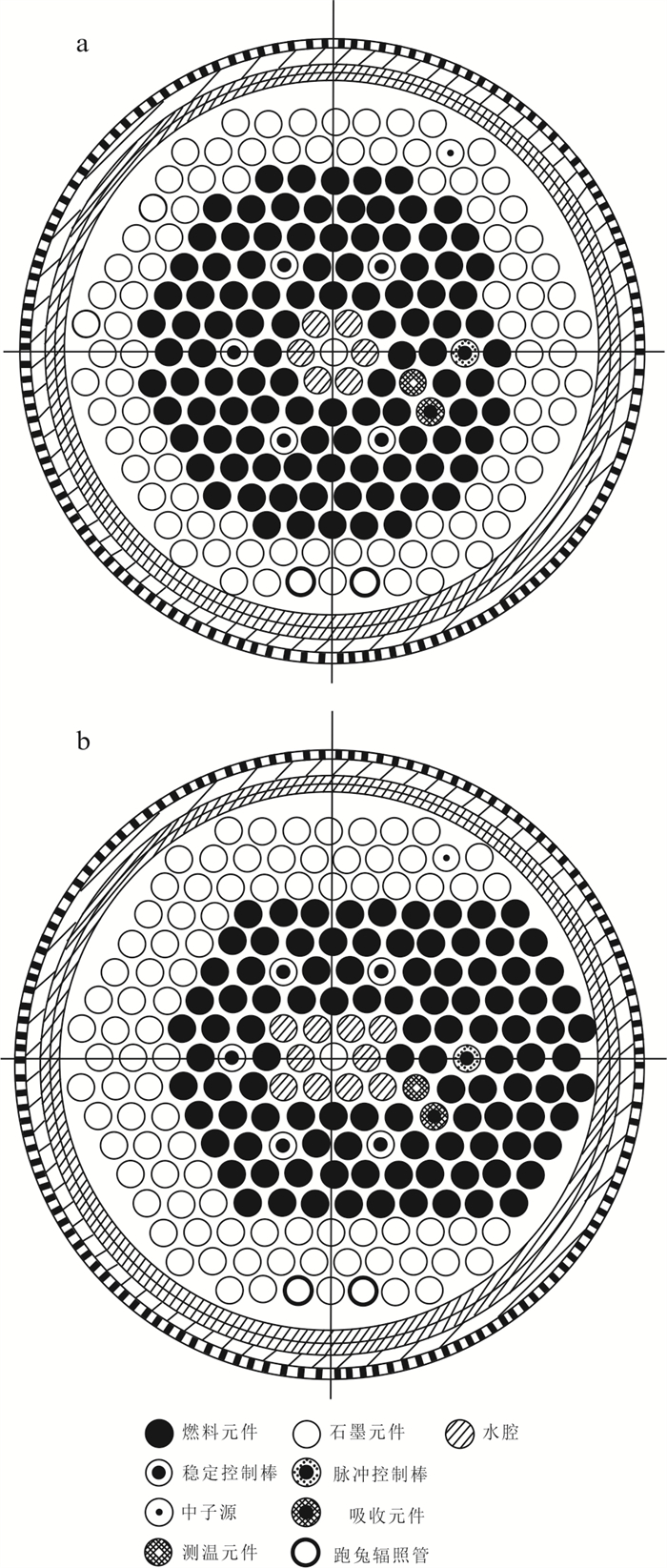
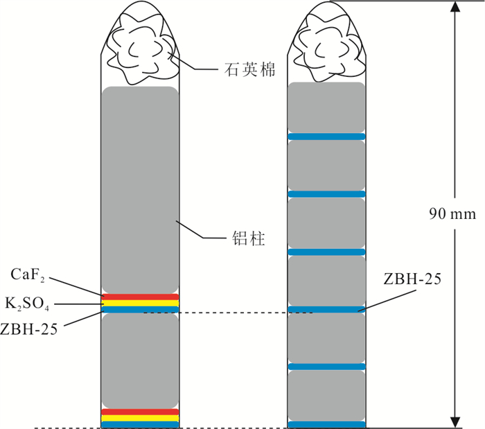
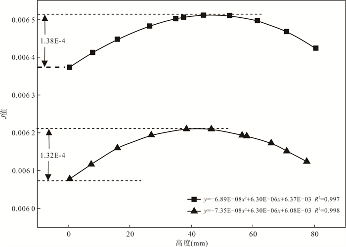
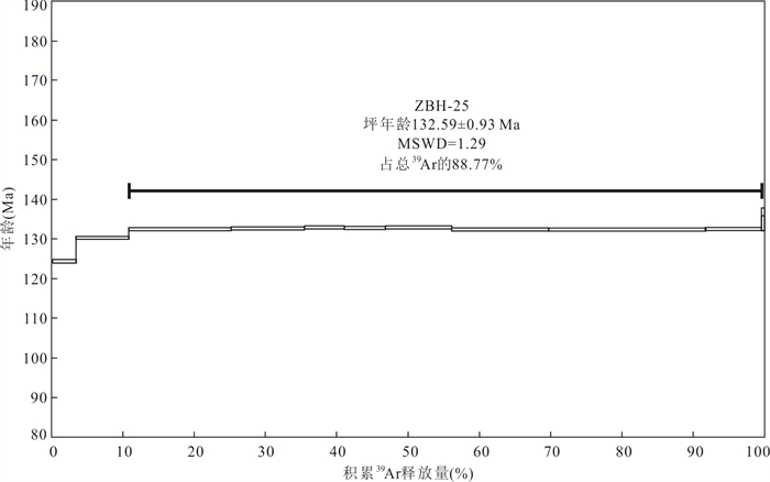
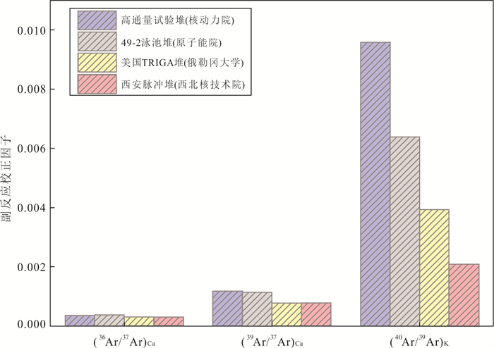
Domestic sample irradiation resources are limited, with few reactors available, infrequent reactor startups, and a lack of systematic research on the parameters for reactor irradiation samples. These limitations hinder the progress of scientific research in 40Ar/39Ar dating. Therefore, it is essential to develop new irradiation resources. For the first time, the irradiation conditions for 40Ar/39Ar dating samples in the Xi'an Pulsed Reactor (XAPR) were studied. The radial and axial gradient changes in neutron flux were determined using the biotite standard material ZBH-25, and the correction factors for side reactions were obtained using potassium salt and calcium salt. The results indicate that the radial J value of the irradiation channel is 0.49%, and a peak neutron flux, suggesting that the sample is irradiated in the center of the reactor. The axial neutron flux gradient in the irradiation channel is 0.54% /cm, and the correction factors in the XAPR irradiation channel are (40Ar/39Ar)K =0.002 082 6, (39Ar/37Ar)Ca =0.000 776 92, (36Ar/37Ar)Ca =0.000 299 98. The standard material ZBH-25 biotite was dated, confirming that the reactor meets the irradiation conditions for 40Ar/39Ar dating samples and can serve as a new irradiation source.
Domestic sample irradiation resources are limited, with few reactors available, infrequent reactor startups, and a lack of systematic research on the parameters for reactor irradiation samples. These limitations hinder the progress of scientific research in 40Ar/39Ar dating. Therefore, it is essential to develop new irradiation resources. For the first time, the irradiation conditions for 40Ar/39Ar dating samples in the Xi'an Pulsed Reactor (XAPR) were studied. The radial and axial gradient changes in neutron flux were determined using the biotite standard material ZBH-25, and the correction factors for side reactions were obtained using potassium salt and calcium salt. The results indicate that the radial J value of the irradiation channel is 0.49%, and a peak neutron flux, suggesting that the sample is irradiated in the center of the reactor. The axial neutron flux gradient in the irradiation channel is 0.54% /cm, and the correction factors in the XAPR irradiation channel are (40Ar/39Ar)K =0.002 082 6, (39Ar/37Ar)Ca =0.000 776 92, (36Ar/37Ar)Ca =0.000 299 98. The standard material ZBH-25 biotite was dated, confirming that the reactor meets the irradiation conditions for 40Ar/39Ar dating samples and can serve as a new irradiation source.
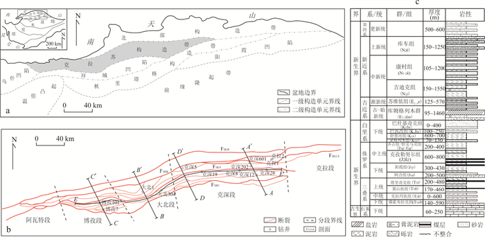
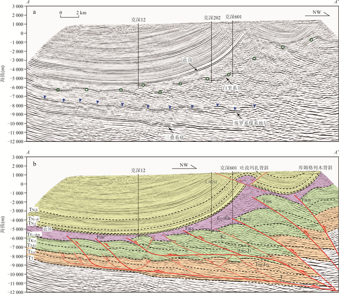
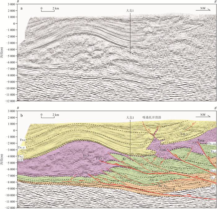
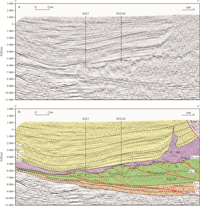
2025, 50(1): 97-109.
doi: 10.3799/dqkx.2024.060
Abstract:
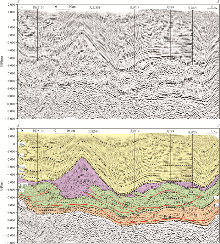
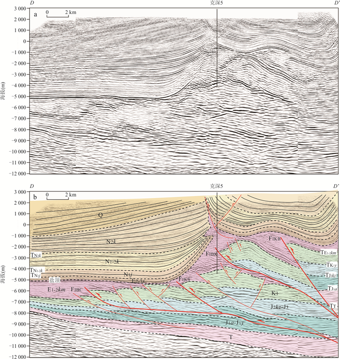
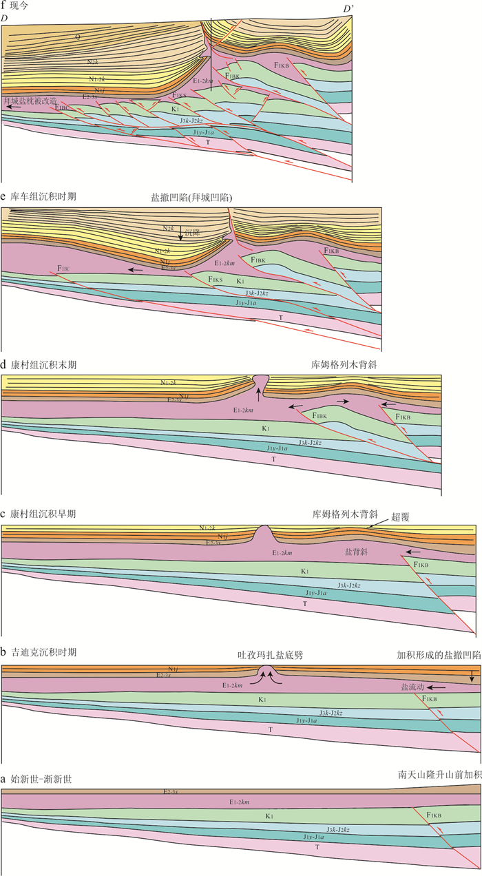
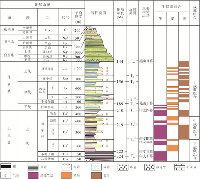
To further investigate the subsalt structure and its spatial variations within the Kelasu structural belt of the Kuqa Depression, we conducted a detailed structural interpretation of the latest high-quality 3D seismic data in this study. The findings reveal the presence of multiple subsalt décollements that significantly control the subsalt structures in the deep areas of the Kelasu structural belt. Specifically, the Jurassic coal-bearing strata emerge as the primary décollement layer beneath the salt layer. Additionally, lower décollement layer within the Triassic strata were observed in the eastern Kelasu structural belt, while they were absent in the western part. The formation of the lower décollement layer is predominantly influenced by the thickness and lithological composition of the Triassic strata, which are in turn controlled by the shape of the basement. Serving as décollement layer, the Jurassic coal-bearing strata facilitate the stratified migration and accumulation of hydrocarbons sourced from the Triassic and Jurassic formations. Consequently, this process has resulted in the development of two distinct hydrocarbon reservoir systems within the deep subsalt layers of the Kuqa Depression: the mid-combination and lower-combination reservoir systems. Notably, the lower-combination reservoir system, primarily composed of the Triassic-Jurassic Yangxia Formation, is structurally stable and is unruptured by deeply situated large-scale faults. This stability may make it conducive to reservoir development that accumulates the Triassic near-source oil and gas, which is the key target for future deep exploration in the Kelasu structural belt.
To further investigate the subsalt structure and its spatial variations within the Kelasu structural belt of the Kuqa Depression, we conducted a detailed structural interpretation of the latest high-quality 3D seismic data in this study. The findings reveal the presence of multiple subsalt décollements that significantly control the subsalt structures in the deep areas of the Kelasu structural belt. Specifically, the Jurassic coal-bearing strata emerge as the primary décollement layer beneath the salt layer. Additionally, lower décollement layer within the Triassic strata were observed in the eastern Kelasu structural belt, while they were absent in the western part. The formation of the lower décollement layer is predominantly influenced by the thickness and lithological composition of the Triassic strata, which are in turn controlled by the shape of the basement. Serving as décollement layer, the Jurassic coal-bearing strata facilitate the stratified migration and accumulation of hydrocarbons sourced from the Triassic and Jurassic formations. Consequently, this process has resulted in the development of two distinct hydrocarbon reservoir systems within the deep subsalt layers of the Kuqa Depression: the mid-combination and lower-combination reservoir systems. Notably, the lower-combination reservoir system, primarily composed of the Triassic-Jurassic Yangxia Formation, is structurally stable and is unruptured by deeply situated large-scale faults. This stability may make it conducive to reservoir development that accumulates the Triassic near-source oil and gas, which is the key target for future deep exploration in the Kelasu structural belt.
2025, 50(1): 110-126.
doi: 10.3799/dqkx.2022.387
Abstract:
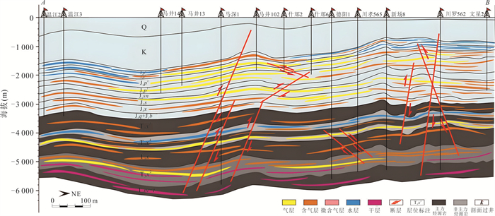
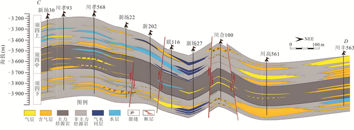
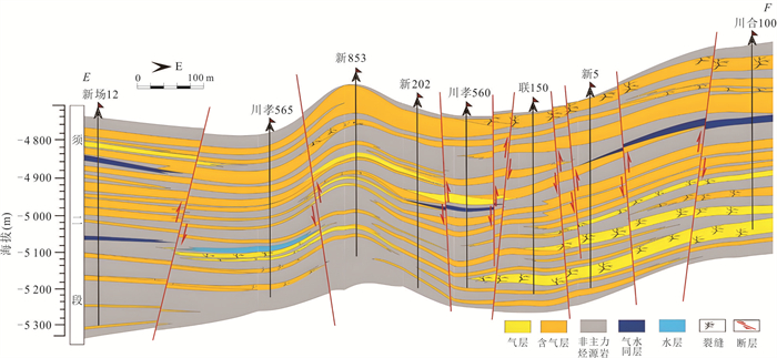
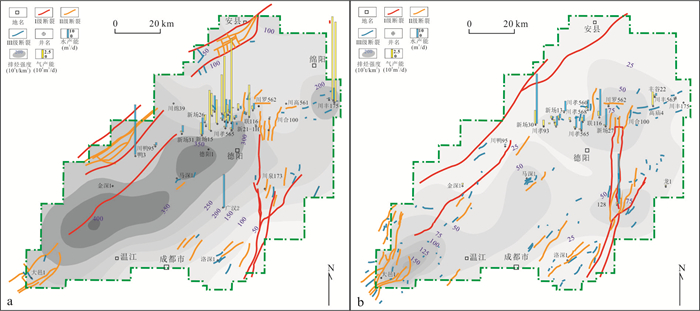
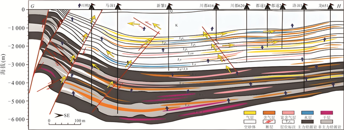
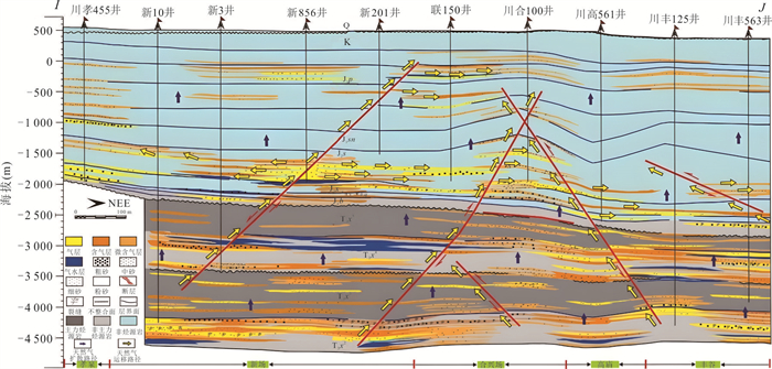
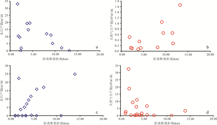
Deep-buried superimposed tight sandstone gas reservoirs in the western Sichuan Depression are characterized by intensive heterogeneity with obvious water production. However, the mechanisms of gas-water distribution and its evolutionary processes are still unclear, which constrains the natural gas exploration and exploitation severely. Based on the data of drilling, well-logging, production and laboratory experiments, this study reveals the distribution characteristics, controlling factors and mechanisms of gas-water distribution of the tight gas reservoirs in upper Triassic Xujiahe Formation. Furthermore, this study also establishes a genetic evolution model of gas-water distribution. The research results show obvious disparity of gas-water distribution between different members of Xujiahe Formation. The gas-water distribution in the upper 4th Member of the Xujiahe Formation shows "layer-like" pattern, which is characterized by vague gas-water interface, while the regular distribution pattern (gas over water) and reverse distribution pattern (water over gas) with obvious gas-water interface only occur in part of the reservoirs. The gas-water distribution in lower 4th Member and 2nd Member of the Xujiahe Formations is characterized by "water surrounded by gas" pattern, the formation water is characterized by "island-like" distribution pattern. The hydrocarbon generating capacity of source rocks controlled the gas-water distribution at macroscopic level, while faults had dual influences of connecting and disrupting on the gas-water distribution. The reservoir heterogeneity further adjusted the water-gas distribution. The distribution of microscopic pore fluids had significant influence on water-gas distribution of the tight sandstone gas reservoirs, the three hydrodynamic fields controlled by pore fluids led to different occurrence characteristics of formation water and hence the different gas-water distribution. According to the evolution of hydrodynamic fields, hydrocarbon generating and expelling history and characteristics of tectonic evolution, the formation and evolutionary processes of formation water distribution were divided into four stages. The first stage was gas-water differentiation stage controlled by free hydrodynamic field with early-period hydrocarbon expulsion before the end of Early Jurassic. The second stage was formation water distinction stage controlled by different hydrodynamic fields with hydrocarbon expulsion peak from Early Jurassic to the end of Late Jurassic. The third stage was formation water adjustment period controlled by different hydrodynamic fields with hydrocarbon expulsion peak from Early Cretaceous to the end of Cretaceous. The fourth stage was gas-water distribution stereotype stage at present.
Deep-buried superimposed tight sandstone gas reservoirs in the western Sichuan Depression are characterized by intensive heterogeneity with obvious water production. However, the mechanisms of gas-water distribution and its evolutionary processes are still unclear, which constrains the natural gas exploration and exploitation severely. Based on the data of drilling, well-logging, production and laboratory experiments, this study reveals the distribution characteristics, controlling factors and mechanisms of gas-water distribution of the tight gas reservoirs in upper Triassic Xujiahe Formation. Furthermore, this study also establishes a genetic evolution model of gas-water distribution. The research results show obvious disparity of gas-water distribution between different members of Xujiahe Formation. The gas-water distribution in the upper 4th Member of the Xujiahe Formation shows "layer-like" pattern, which is characterized by vague gas-water interface, while the regular distribution pattern (gas over water) and reverse distribution pattern (water over gas) with obvious gas-water interface only occur in part of the reservoirs. The gas-water distribution in lower 4th Member and 2nd Member of the Xujiahe Formations is characterized by "water surrounded by gas" pattern, the formation water is characterized by "island-like" distribution pattern. The hydrocarbon generating capacity of source rocks controlled the gas-water distribution at macroscopic level, while faults had dual influences of connecting and disrupting on the gas-water distribution. The reservoir heterogeneity further adjusted the water-gas distribution. The distribution of microscopic pore fluids had significant influence on water-gas distribution of the tight sandstone gas reservoirs, the three hydrodynamic fields controlled by pore fluids led to different occurrence characteristics of formation water and hence the different gas-water distribution. According to the evolution of hydrodynamic fields, hydrocarbon generating and expelling history and characteristics of tectonic evolution, the formation and evolutionary processes of formation water distribution were divided into four stages. The first stage was gas-water differentiation stage controlled by free hydrodynamic field with early-period hydrocarbon expulsion before the end of Early Jurassic. The second stage was formation water distinction stage controlled by different hydrodynamic fields with hydrocarbon expulsion peak from Early Jurassic to the end of Late Jurassic. The third stage was formation water adjustment period controlled by different hydrodynamic fields with hydrocarbon expulsion peak from Early Cretaceous to the end of Cretaceous. The fourth stage was gas-water distribution stereotype stage at present.
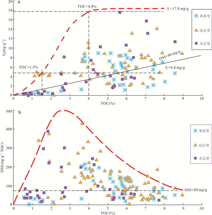
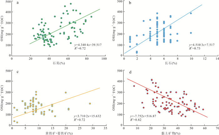
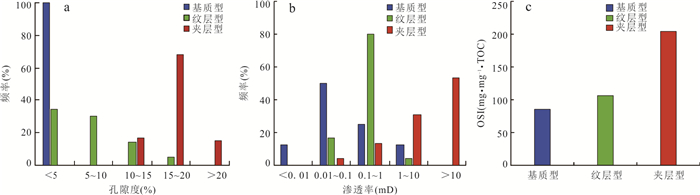
2025, 50(1): 127-143.
doi: 10.3799/dqkx.2024.034
Abstract:
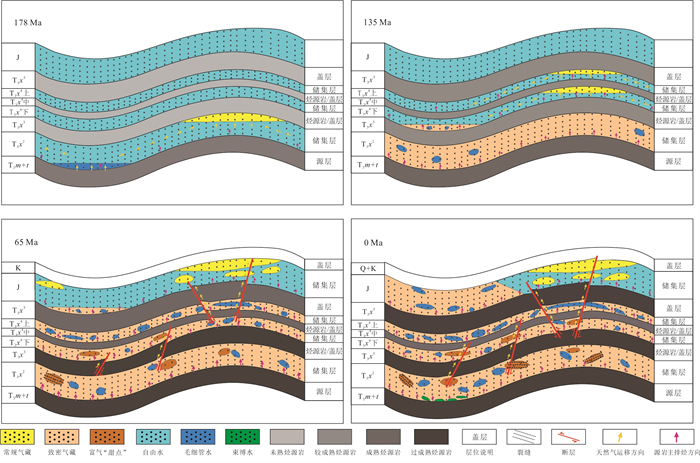
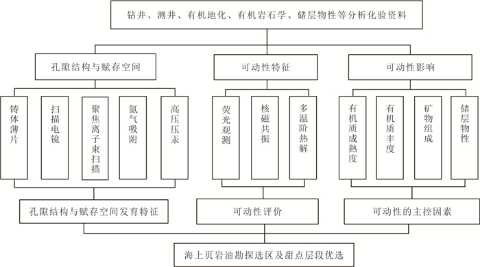
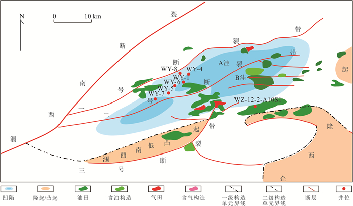
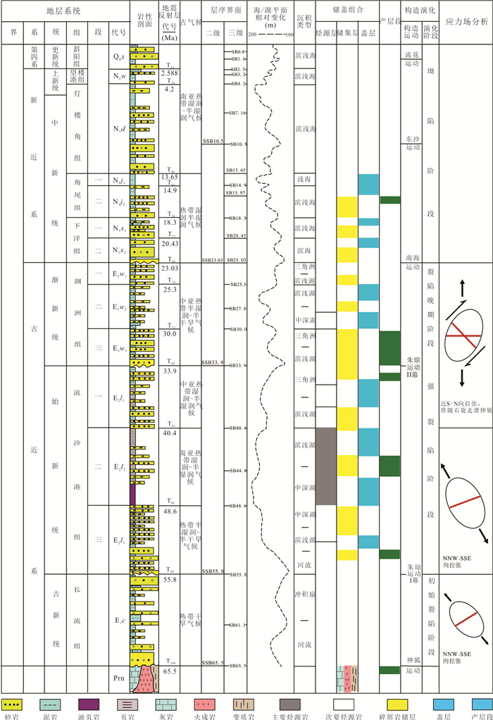
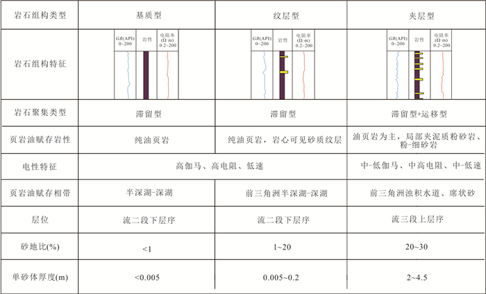
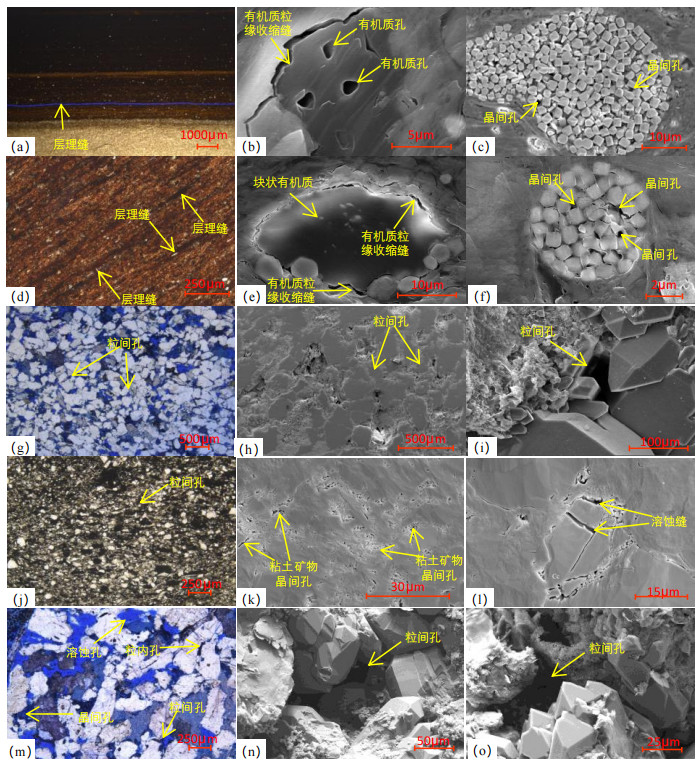
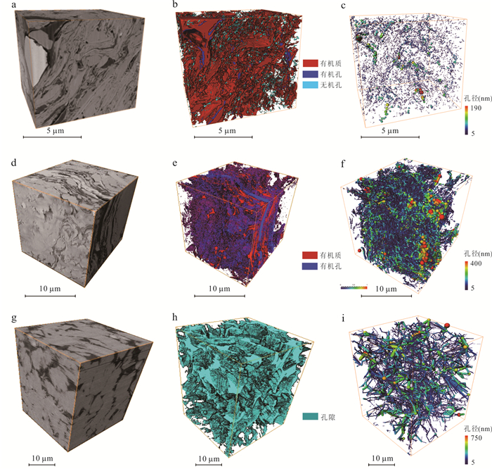
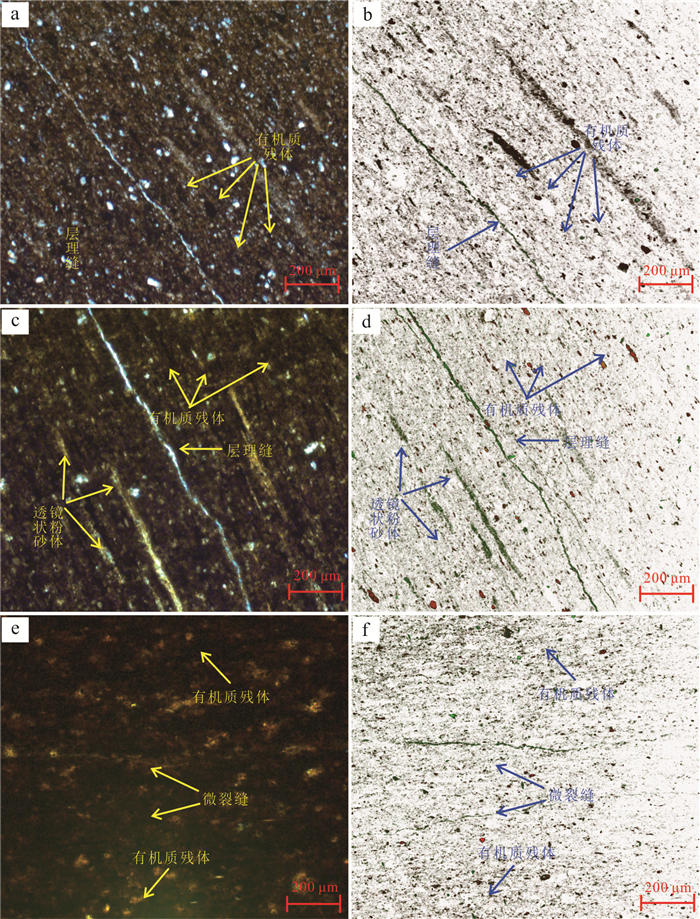
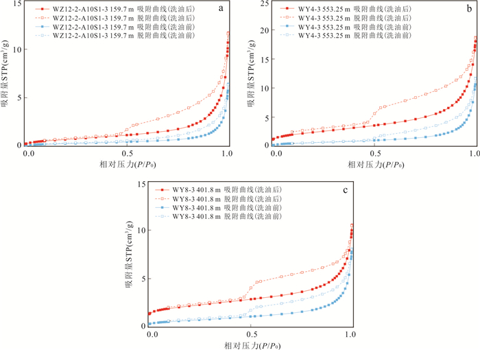
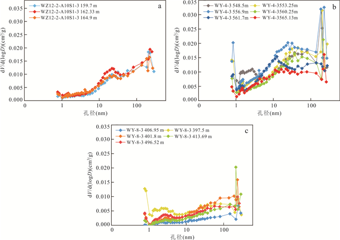
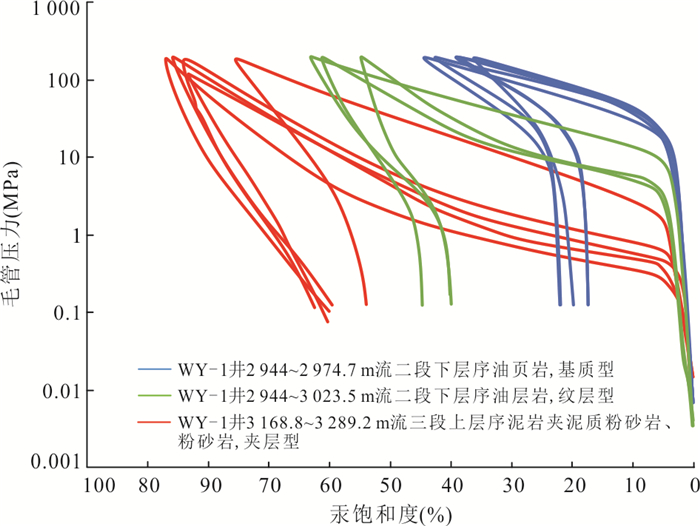
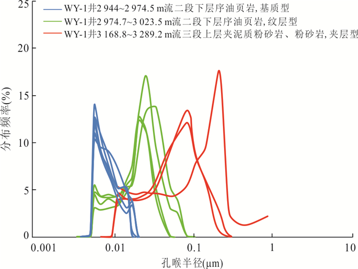
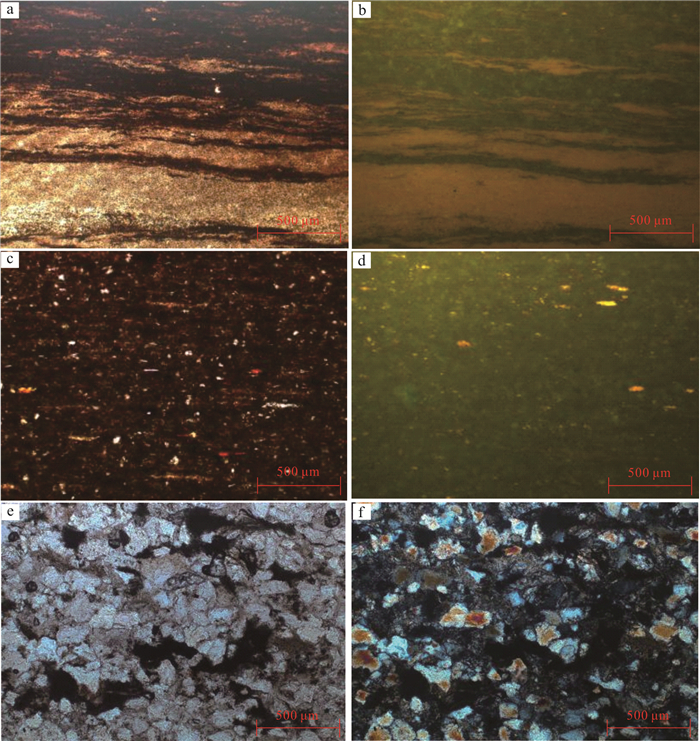
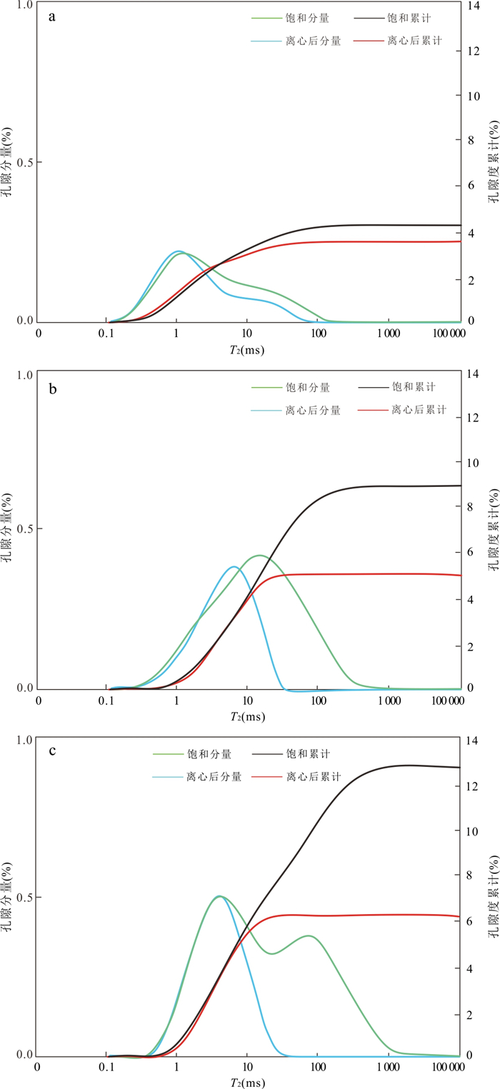
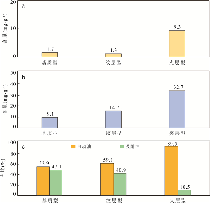
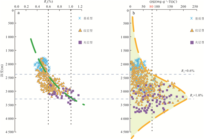
In order to clarify the occurrence space and mobility characteristics of shale oil in the Liushagang Formation of the Weixinan Sag in Beibuwan Basin, comprehensive experimental techniques such as thin section identification, fluorescence observation, scanning electron microscopy, nitrogen adsorption, high-pressure mercury injection, digital core analysis, nuclear magnetic resonance, and multi-temperature pyrolysis were utilized to qualitatively and quantitatively investigate the pore structure, occurrence space, and mobility characteristics of different types of shale oil reservoirs in the Liushagang Formation of the Weixinan Sag. Results show that: (1) matrix-type shales mainly contain nanoscale pores in organic matter, intergranular pores in pyrite, interparticle pores in clay minerals, fractures at bedding interface, as well as shrinkage fractures on the edge of organic matter particles. Oil in the matrix-type shales mainly stores in pores with pore throat radius less than 10 nm. In addition to organic pores, intergranular pores and microfractures, there are intergranular and intragranular pores developed in laminated shale oil reservoirs. Oil in the laminated shales mainly stores in pore spaces with pore throat radius between 10 nm and 50 nm. The "sandwiched" shales mainly contain intergranular pores, intergranular pores, intraparticle pores, and dissolution-related pores at the nanometer to micrometer scale. Oil in the "sandwiched" shales mainly exists in pore spaces with pore throat radius ranging from 100 to 1 000 nm. (2) There are significant differences in the oil mobility of different types of shales. Among them, the "sandwiched" shales have the best mobility. The maximum movable oil content of the "sandwiched" shales is between 22.78 and 42.63 mg/g (averaging 32.71 mg/g), and the movable oil proportion is higher than 80%. The second is the laminated shales, with the maximum movable oil content of 1.78-16.35 mg/g (averaging 10.88 mg/g), and the movable oil proportion of about 60%. The matrix-type shales have the lowest movable oil content and movable oil proportion. (3) The abundance and thermal maturity of organic matter, reservoir pore space, and mineral composition control the shale oil mobility; When the thermal maturity (Ro) is around 1.0% and TOC content is between 1.5% and 4%, shale reservoirs are mostly enriched in movable oil. In addition, the larger the pore throat radius, the better the physical properties, the higher content of brittle minerals, the lower content of clay minerals, the better shale oil movability. Based on the above results, the "sandwiched" shales have the largest storage space and the best mobility, and are the preferred target for shale oil exploration in the Weixinan Sag. These are the basis for the significant breakthroughs in offshore shale oil drilling.
In order to clarify the occurrence space and mobility characteristics of shale oil in the Liushagang Formation of the Weixinan Sag in Beibuwan Basin, comprehensive experimental techniques such as thin section identification, fluorescence observation, scanning electron microscopy, nitrogen adsorption, high-pressure mercury injection, digital core analysis, nuclear magnetic resonance, and multi-temperature pyrolysis were utilized to qualitatively and quantitatively investigate the pore structure, occurrence space, and mobility characteristics of different types of shale oil reservoirs in the Liushagang Formation of the Weixinan Sag. Results show that: (1) matrix-type shales mainly contain nanoscale pores in organic matter, intergranular pores in pyrite, interparticle pores in clay minerals, fractures at bedding interface, as well as shrinkage fractures on the edge of organic matter particles. Oil in the matrix-type shales mainly stores in pores with pore throat radius less than 10 nm. In addition to organic pores, intergranular pores and microfractures, there are intergranular and intragranular pores developed in laminated shale oil reservoirs. Oil in the laminated shales mainly stores in pore spaces with pore throat radius between 10 nm and 50 nm. The "sandwiched" shales mainly contain intergranular pores, intergranular pores, intraparticle pores, and dissolution-related pores at the nanometer to micrometer scale. Oil in the "sandwiched" shales mainly exists in pore spaces with pore throat radius ranging from 100 to 1 000 nm. (2) There are significant differences in the oil mobility of different types of shales. Among them, the "sandwiched" shales have the best mobility. The maximum movable oil content of the "sandwiched" shales is between 22.78 and 42.63 mg/g (averaging 32.71 mg/g), and the movable oil proportion is higher than 80%. The second is the laminated shales, with the maximum movable oil content of 1.78-16.35 mg/g (averaging 10.88 mg/g), and the movable oil proportion of about 60%. The matrix-type shales have the lowest movable oil content and movable oil proportion. (3) The abundance and thermal maturity of organic matter, reservoir pore space, and mineral composition control the shale oil mobility; When the thermal maturity (Ro) is around 1.0% and TOC content is between 1.5% and 4%, shale reservoirs are mostly enriched in movable oil. In addition, the larger the pore throat radius, the better the physical properties, the higher content of brittle minerals, the lower content of clay minerals, the better shale oil movability. Based on the above results, the "sandwiched" shales have the largest storage space and the best mobility, and are the preferred target for shale oil exploration in the Weixinan Sag. These are the basis for the significant breakthroughs in offshore shale oil drilling.
2025, 50(1): 144-157.
doi: 10.3799/dqkx.2024.080
Abstract:
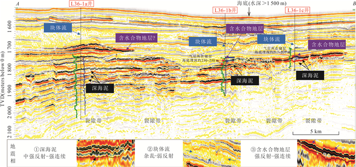
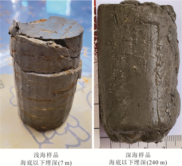
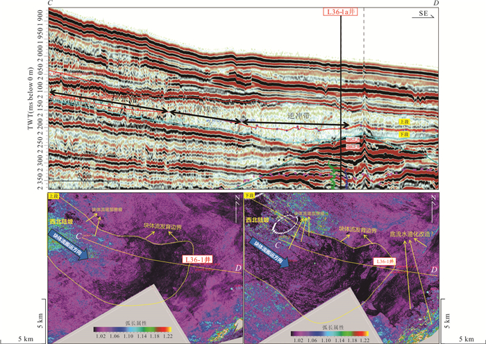
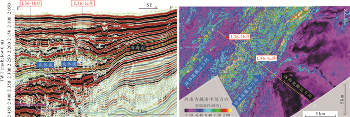
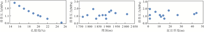
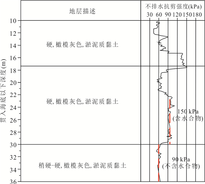
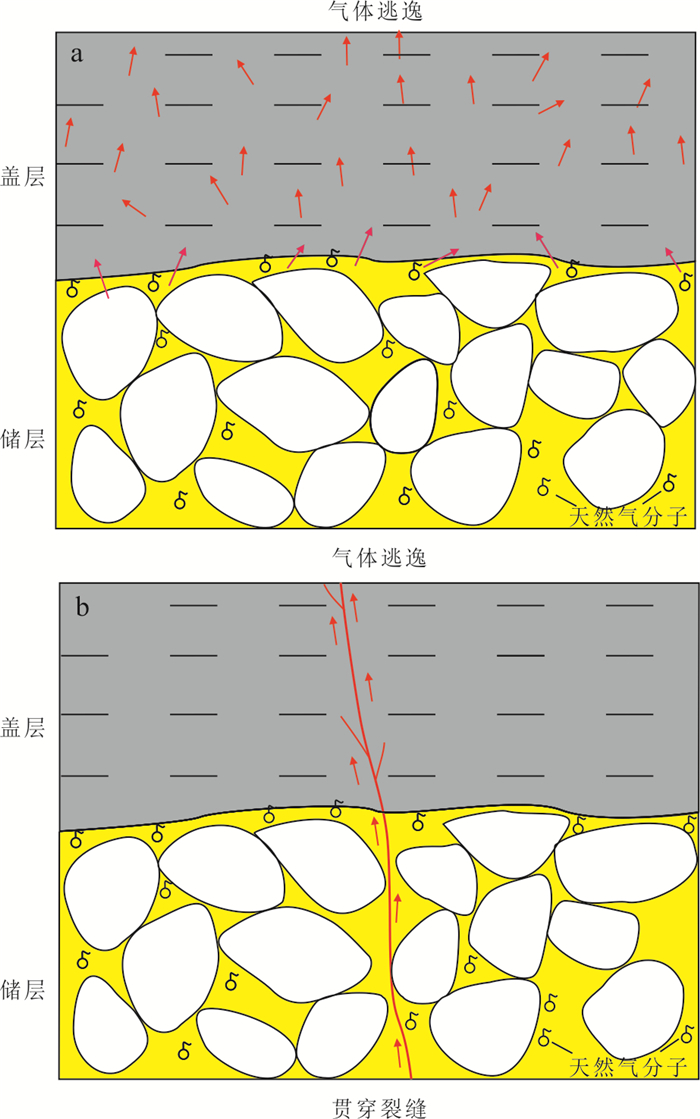
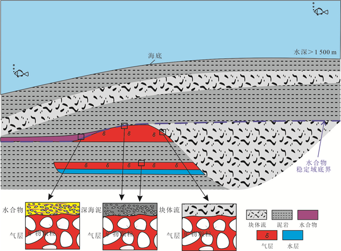
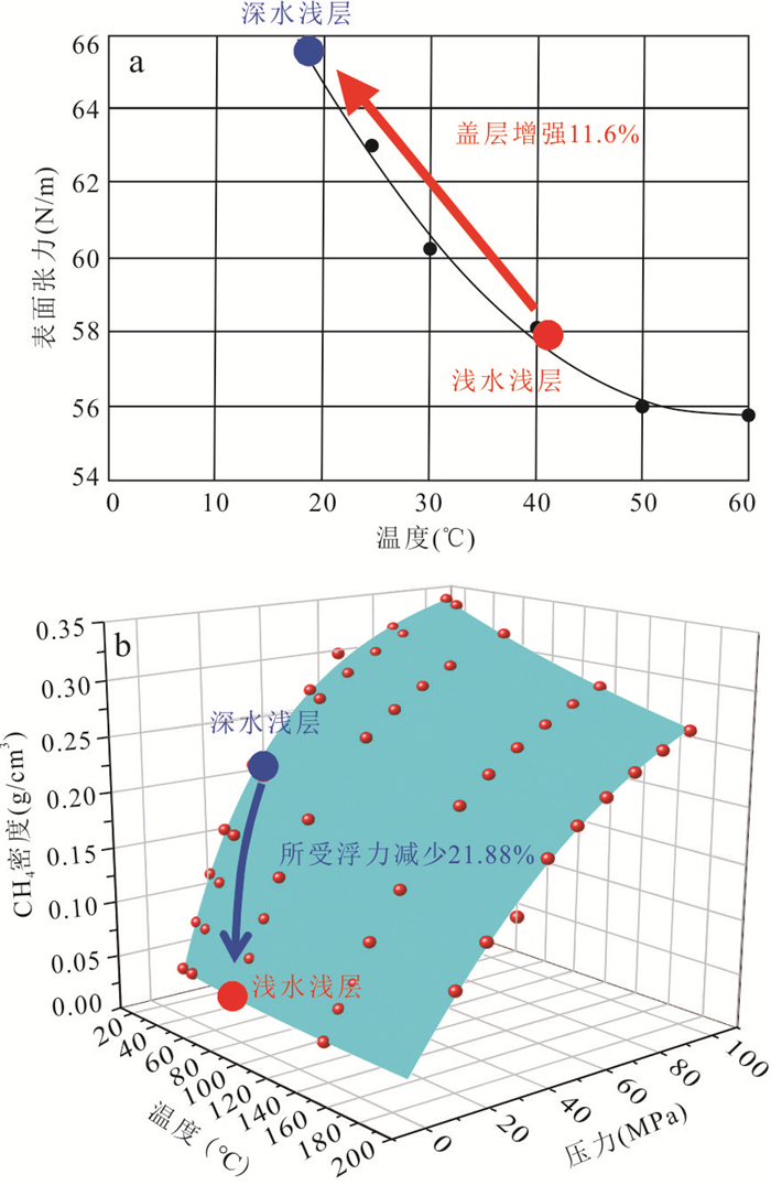
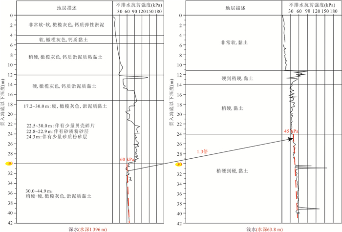
Caprock plays an important role in determining whether hydrocarbon accumulation is available. Previous studies of caprock mainly focus on the sealing ability of medium-deep consolidated rock, while less attention is paid to the shallow unconsolidated caprock, and the evaluation of caprock of shallow buried formations in deep water area is rare. Based on the research results of seismic interpretation, uniaxial stress test, logging evaluation, and cone penetration test in the deep water area of Qiongdongnan Basin, the development type and sealing ability of the caprock for the gas reservoir of the Ledong Formation in the L36 area are studied in this paper. The results show that: (1) There are three types of caprock (deep-sea mud, mass transport deposits, and hydrate-bearing strata) in the deep water area of the Ledong Formation, which could all have the effective sealing effect. (2) Based on the seismic and geological interpretation and experimental results, it is clear that the sealing capacity increases in the order of deep-sea mud, mass transport deposits, and hydrate-bearing strata; and the deep-sea mud can seal 59 m hydrocarbon at 200 m below seafloor, which is the threshold of sealing ability for the main target layer in the study area. (3) The capillary sealing and hydraulic sealing plays a dominant role in the sealing mechanism of shallow buried caprock in the deep water area, under low temperature and high pressure environment, the saturated salt water sealing mechanism plays a characteristic role in increasing sealing capacity. The above results have been verified by drilling in the past two years, which not only provides a theoretical basis for the follow-up exploration and development of the Ledong Formation in Qiongdongnan Basin, but also can provide a useful reference for the natural gas exploration in other shallow buried areas in the deep water area.
Caprock plays an important role in determining whether hydrocarbon accumulation is available. Previous studies of caprock mainly focus on the sealing ability of medium-deep consolidated rock, while less attention is paid to the shallow unconsolidated caprock, and the evaluation of caprock of shallow buried formations in deep water area is rare. Based on the research results of seismic interpretation, uniaxial stress test, logging evaluation, and cone penetration test in the deep water area of Qiongdongnan Basin, the development type and sealing ability of the caprock for the gas reservoir of the Ledong Formation in the L36 area are studied in this paper. The results show that: (1) There are three types of caprock (deep-sea mud, mass transport deposits, and hydrate-bearing strata) in the deep water area of the Ledong Formation, which could all have the effective sealing effect. (2) Based on the seismic and geological interpretation and experimental results, it is clear that the sealing capacity increases in the order of deep-sea mud, mass transport deposits, and hydrate-bearing strata; and the deep-sea mud can seal 59 m hydrocarbon at 200 m below seafloor, which is the threshold of sealing ability for the main target layer in the study area. (3) The capillary sealing and hydraulic sealing plays a dominant role in the sealing mechanism of shallow buried caprock in the deep water area, under low temperature and high pressure environment, the saturated salt water sealing mechanism plays a characteristic role in increasing sealing capacity. The above results have been verified by drilling in the past two years, which not only provides a theoretical basis for the follow-up exploration and development of the Ledong Formation in Qiongdongnan Basin, but also can provide a useful reference for the natural gas exploration in other shallow buried areas in the deep water area.
2025, 50(1): 158-171.
doi: 10.3799/dqkx.2024.068
Abstract:
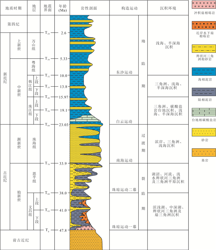
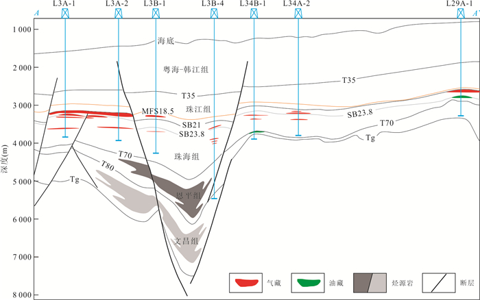
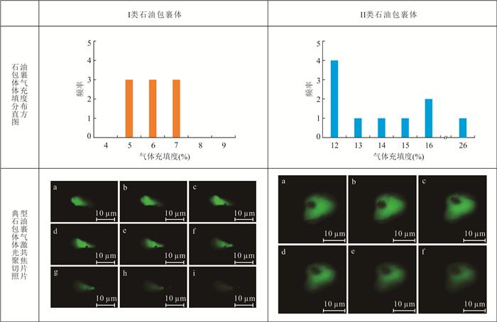
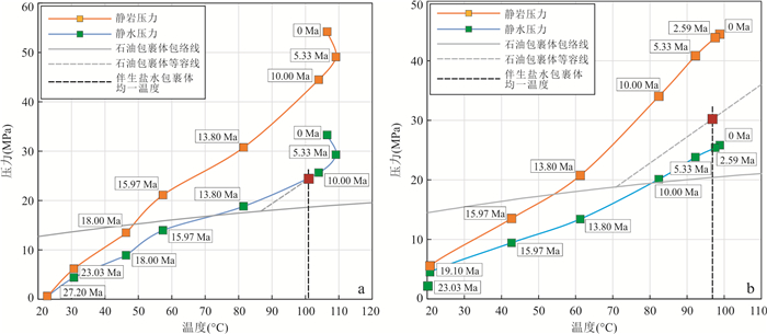
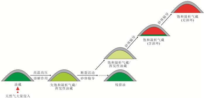
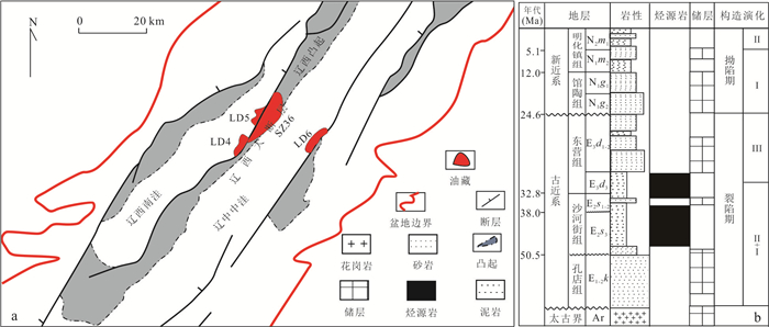
The Baiyun Sag, situated in the southern part of the Pearl River Mouth Basin, is an area for active deep-water oil and gas exploration in China. Insight into the oil and gas charge history in the area is crucial for further oil and gas exploration. Based on detailed investigation of oil and gas reservoirs in the eastern Baiyun Sag, this study aims to provide a better understanding of the oil and gas charge history through an integrated fluid inclusion analysis, PVT and basin modeling. The results indicate that: (1) The eastern Baiyun Sag is dominated by gas condensate with some locally developed oil reservoirs. The overall distribution pattern shows that gas occurs in the shallow reservoirs while oil in the deeper reservoirs. In structural highs, gas condensate reservoirs are characterized by relatively high gas dryness coefficient and gas-oil ratio (GOR). (2) Two different types of oil inclusion assemblages (OIAs) have been identified in the reservoirs: Type Ⅰ OIA is characterized by gas-liquid phases at room temperature, emitting yellowish white and yellowish green fluorescence. The vapor filling degree is generally less than 10%, and the homogenization temperature (Th) is 86.2-93.2 ℃. The Th and final ice-melting temperature (Tm) of the coeval aqueous inclusions are 100.9-104.1 ℃ and -4.3 ℃ to -4.2 ℃, respectively. Type Ⅱ OIA is featured by gas-liquid or gas-liquid-solid phases at room temperature, with yellowish green, blue-green, and blue-white fluorescence. The vapor filling degree ranges from 10% to 30%, and the Th values are in the range of 71.1 ℃ to 112.4 ℃. The Th and Tm values of the coeval aqueous inclusions are 96.8-108.6 ℃ and -3.2 ℃ to -2.7 ℃, respectively. (3) The oil and gas charge event corresponding to Type Ⅰ OIA occurred at approximately 10.8 Ma under a normal hydrostatic pressure condition, whereas the equivalent oil and gas charge timing of Type Ⅱ OIA was around 2.8 Ma, under a weak overpressure condition. (4) Some oil reservoirs were entrapped in the eastern Baiyun Sag during the Zhujiang-Hanjiang Formation depositional periods. From the Yuehai Formation depositional period to the present, deep hydrocarbons, mainly in over-pressured gas, migrated vertically along faults upwards to the regional caprock, and then migrated laterally along interconnected sandbodies to accumulate in early traps, altering early oil accumulations and forming a series of condensate gas reservoirs via compositional fractionation during migration.
The Baiyun Sag, situated in the southern part of the Pearl River Mouth Basin, is an area for active deep-water oil and gas exploration in China. Insight into the oil and gas charge history in the area is crucial for further oil and gas exploration. Based on detailed investigation of oil and gas reservoirs in the eastern Baiyun Sag, this study aims to provide a better understanding of the oil and gas charge history through an integrated fluid inclusion analysis, PVT and basin modeling. The results indicate that: (1) The eastern Baiyun Sag is dominated by gas condensate with some locally developed oil reservoirs. The overall distribution pattern shows that gas occurs in the shallow reservoirs while oil in the deeper reservoirs. In structural highs, gas condensate reservoirs are characterized by relatively high gas dryness coefficient and gas-oil ratio (GOR). (2) Two different types of oil inclusion assemblages (OIAs) have been identified in the reservoirs: Type Ⅰ OIA is characterized by gas-liquid phases at room temperature, emitting yellowish white and yellowish green fluorescence. The vapor filling degree is generally less than 10%, and the homogenization temperature (Th) is 86.2-93.2 ℃. The Th and final ice-melting temperature (Tm) of the coeval aqueous inclusions are 100.9-104.1 ℃ and -4.3 ℃ to -4.2 ℃, respectively. Type Ⅱ OIA is featured by gas-liquid or gas-liquid-solid phases at room temperature, with yellowish green, blue-green, and blue-white fluorescence. The vapor filling degree ranges from 10% to 30%, and the Th values are in the range of 71.1 ℃ to 112.4 ℃. The Th and Tm values of the coeval aqueous inclusions are 96.8-108.6 ℃ and -3.2 ℃ to -2.7 ℃, respectively. (3) The oil and gas charge event corresponding to Type Ⅰ OIA occurred at approximately 10.8 Ma under a normal hydrostatic pressure condition, whereas the equivalent oil and gas charge timing of Type Ⅱ OIA was around 2.8 Ma, under a weak overpressure condition. (4) Some oil reservoirs were entrapped in the eastern Baiyun Sag during the Zhujiang-Hanjiang Formation depositional periods. From the Yuehai Formation depositional period to the present, deep hydrocarbons, mainly in over-pressured gas, migrated vertically along faults upwards to the regional caprock, and then migrated laterally along interconnected sandbodies to accumulate in early traps, altering early oil accumulations and forming a series of condensate gas reservoirs via compositional fractionation during migration.


2025, 50(1): 172-180.
doi: 10.3799/dqkx.2022.442
Abstract:
Organic geochemical analysis in Bohai Sea area of Bohai Bay Basin reveals that low-mature oil and gas are widely found in some structural belts, but the genesis and resource potential of low-mature oil and gas have been ignored and not systematically studied. Taking Liaodong Bay Depression as the research object, the characteristics of low-mature oil are systematically analyzed in combination with different structural unit reservoirs, and the potential and prospect of low-mature oil and gas generation from source rocks are studied. The results show that: (1) Low-mature oil is developed in the Liaodong Bay Depression. The reservoirs in the steep slope belt of South Liaoxi Depression are characterized as belonging to the typical low-mature oil reservoir, with the characteristics of the high density, high acid value, high colloid and high asphaltene, odd-even obvious advantages, and the C14-C16 sesquiterpenes series are complete, with higher gammacerane index. It is obviously different from the reservoirs in the Liaoxi uplift belt and the Liaozhong Depression, immature oil mainly source from saltwater lacustrine source rocks in South Liaoxi Depression. (2) The saltwater source rocks have unique characteristics of double peak hydrocarbon generation, and a large amount of liquid hydrocarbon rich in colloid and asphaltene is generated in the low mature evolution stage, which has rich potential and broad prospects of low mature oil resources.
Organic geochemical analysis in Bohai Sea area of Bohai Bay Basin reveals that low-mature oil and gas are widely found in some structural belts, but the genesis and resource potential of low-mature oil and gas have been ignored and not systematically studied. Taking Liaodong Bay Depression as the research object, the characteristics of low-mature oil are systematically analyzed in combination with different structural unit reservoirs, and the potential and prospect of low-mature oil and gas generation from source rocks are studied. The results show that: (1) Low-mature oil is developed in the Liaodong Bay Depression. The reservoirs in the steep slope belt of South Liaoxi Depression are characterized as belonging to the typical low-mature oil reservoir, with the characteristics of the high density, high acid value, high colloid and high asphaltene, odd-even obvious advantages, and the C14-C16 sesquiterpenes series are complete, with higher gammacerane index. It is obviously different from the reservoirs in the Liaoxi uplift belt and the Liaozhong Depression, immature oil mainly source from saltwater lacustrine source rocks in South Liaoxi Depression. (2) The saltwater source rocks have unique characteristics of double peak hydrocarbon generation, and a large amount of liquid hydrocarbon rich in colloid and asphaltene is generated in the low mature evolution stage, which has rich potential and broad prospects of low mature oil resources.
2025, 50(1): 181-194.
doi: 10.3799/dqkx.2023.163
Abstract:
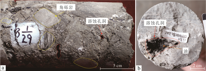
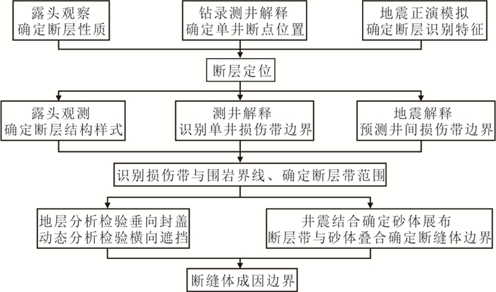
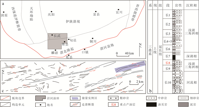
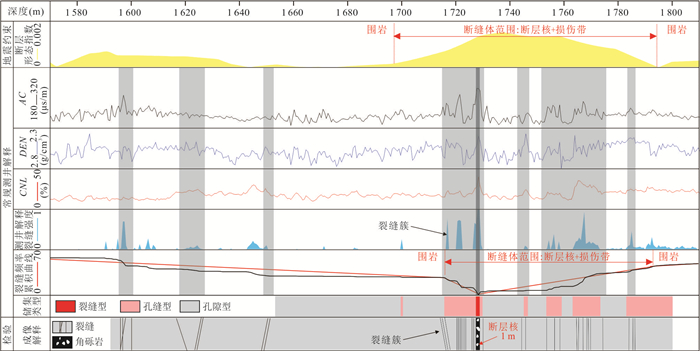
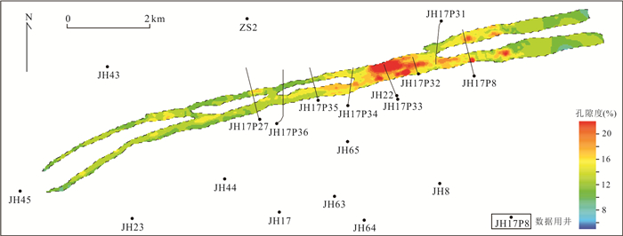
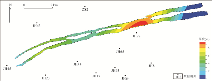
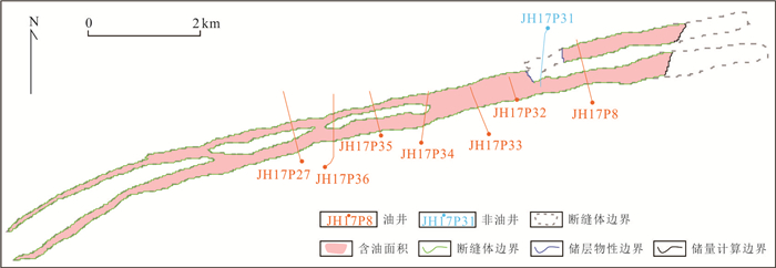
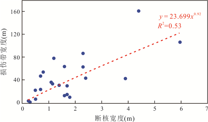
Fault-controlled fracturing reservoirs have become the focused object of exploration and development in Binchang area on the southern margin of Ordos Basin, which usually show diverse reservoir types and complex trap types. Consequently, it is difficult for their geological reserves estimation by volumetric method to reasonably determine the scope of oil-bearing area and the lower limit of effective thickness. An improved volumetric method, referring to those for fractured reservoir and tight oil reservoir, was proposed for the geological reserves estimation, on the basis of the reservoir origin and its features. The ways to determine their related parameters were analyzed. Then the example of fault-controlled fracturing reservoirs from well block JH17 in Binchang area was used to demonstrate the process and some potential issues. It is believed that fault-controlled fracturing reservoirs show the features of tight oil reservoir as a whole, with the local features of structural reservoir and typical water-oil contact near fault surfaces. The lower limit of effective thickness can be determined by considering the factors of reservoir types and local oil-reservoir types. In the case of limited data, fracturing reservoirs can refer to some parameters of the lower limit for the secondary reservoirs with less fractures, such as those of lithology, porosity, permeability and saturation. The scope of oil-bearing area is related to that of fault-controlled fracturing body and the strength of hydrocarbon emplacement. Its determination should consider the distributions of the typical water-oil contact and the tight oil, as well as the "sweet spot" feature and the excellent connectivity along fault strike of fault-controlled fracturing body. According to the scheme, the geological reserves were estimated for the instance of fault-controlled fracturing reservoirs, with a reserves abundance of up to 43×104 t/km2, about three times that of other types of reservoir in the study area.
Fault-controlled fracturing reservoirs have become the focused object of exploration and development in Binchang area on the southern margin of Ordos Basin, which usually show diverse reservoir types and complex trap types. Consequently, it is difficult for their geological reserves estimation by volumetric method to reasonably determine the scope of oil-bearing area and the lower limit of effective thickness. An improved volumetric method, referring to those for fractured reservoir and tight oil reservoir, was proposed for the geological reserves estimation, on the basis of the reservoir origin and its features. The ways to determine their related parameters were analyzed. Then the example of fault-controlled fracturing reservoirs from well block JH17 in Binchang area was used to demonstrate the process and some potential issues. It is believed that fault-controlled fracturing reservoirs show the features of tight oil reservoir as a whole, with the local features of structural reservoir and typical water-oil contact near fault surfaces. The lower limit of effective thickness can be determined by considering the factors of reservoir types and local oil-reservoir types. In the case of limited data, fracturing reservoirs can refer to some parameters of the lower limit for the secondary reservoirs with less fractures, such as those of lithology, porosity, permeability and saturation. The scope of oil-bearing area is related to that of fault-controlled fracturing body and the strength of hydrocarbon emplacement. Its determination should consider the distributions of the typical water-oil contact and the tight oil, as well as the "sweet spot" feature and the excellent connectivity along fault strike of fault-controlled fracturing body. According to the scheme, the geological reserves were estimated for the instance of fault-controlled fracturing reservoirs, with a reserves abundance of up to 43×104 t/km2, about three times that of other types of reservoir in the study area.
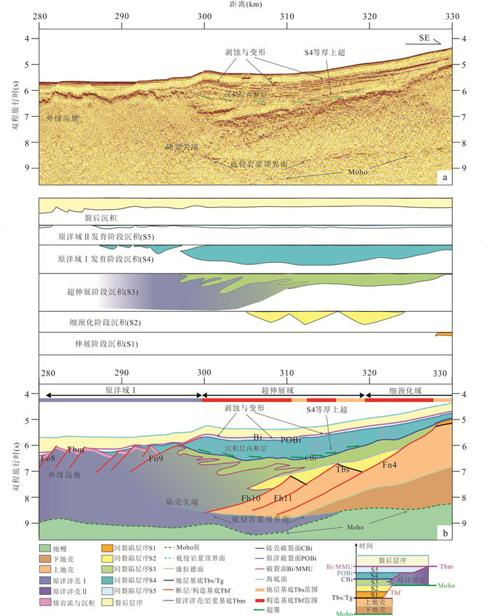
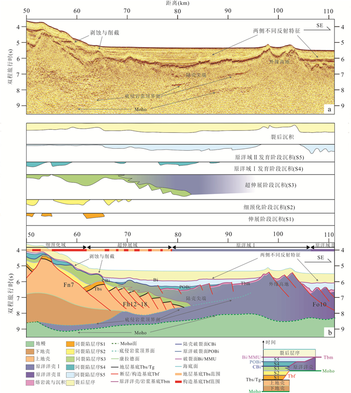
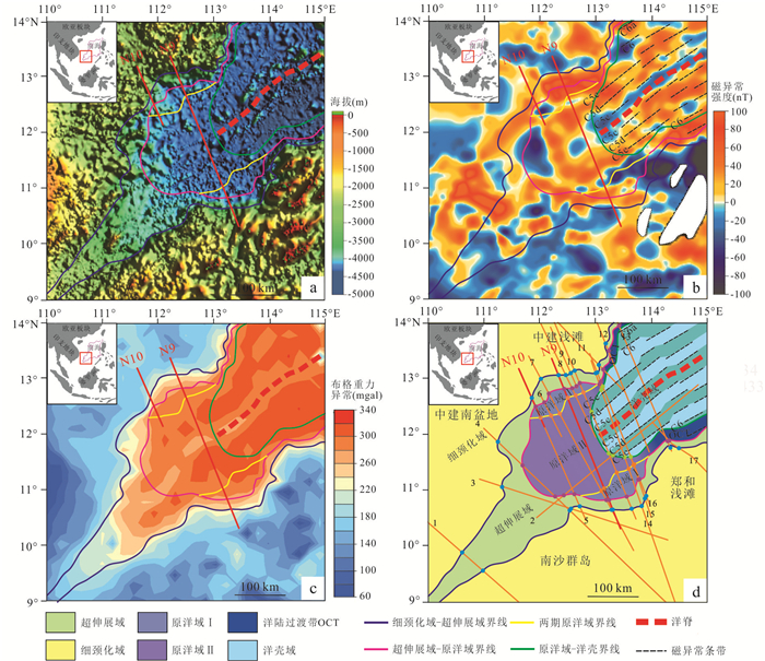
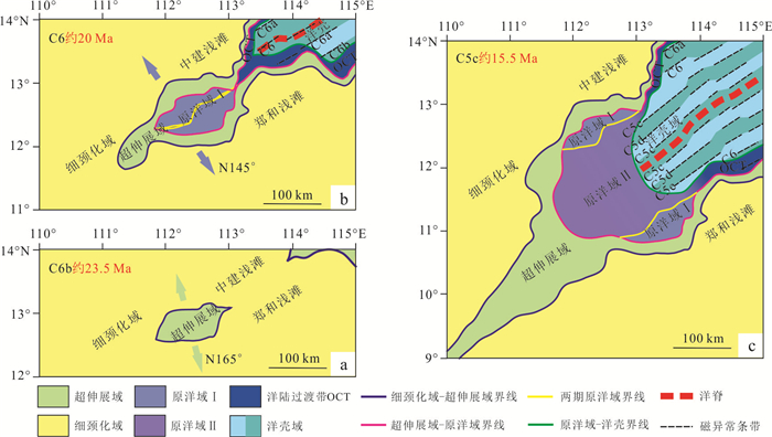
2025, 50(1): 195-216.
doi: 10.3799/dqkx.2024.012
Abstract:
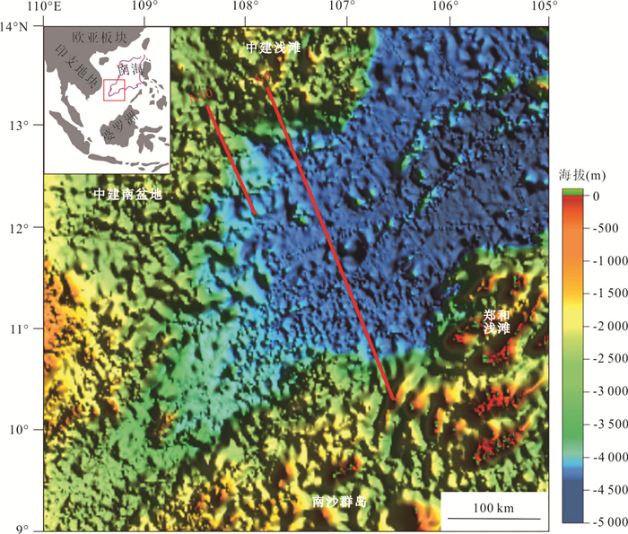
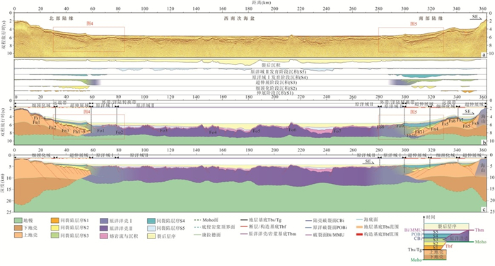
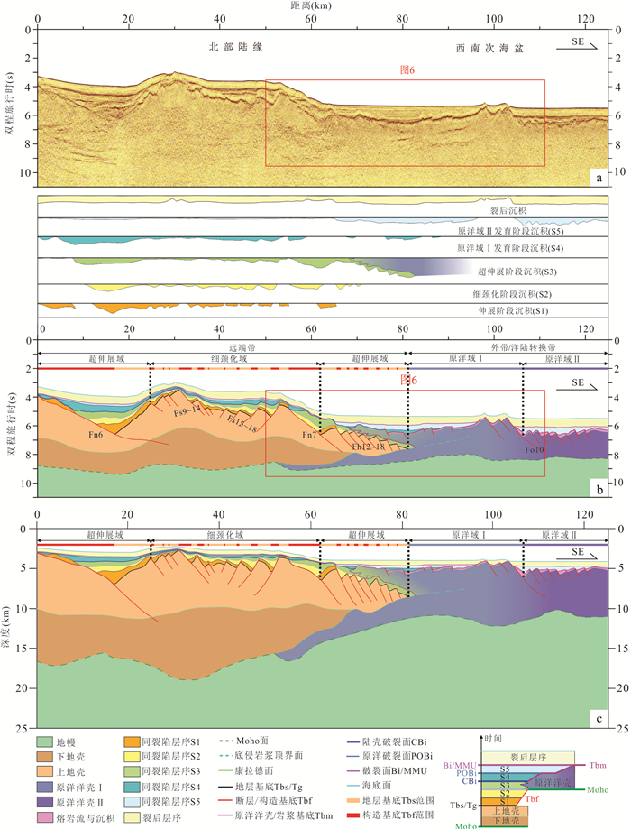
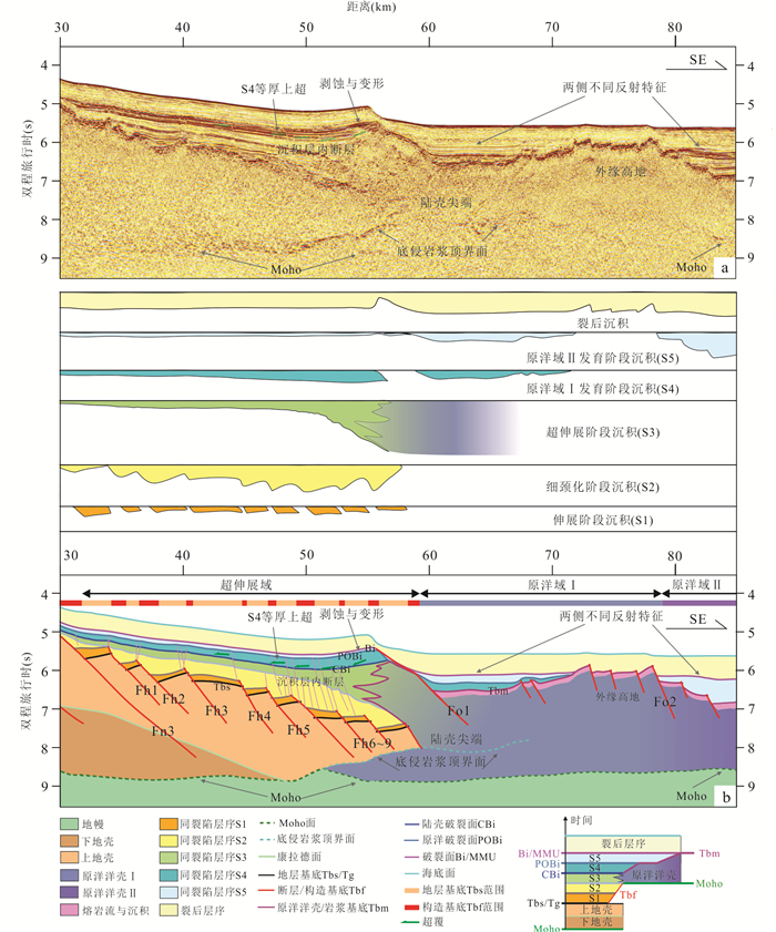
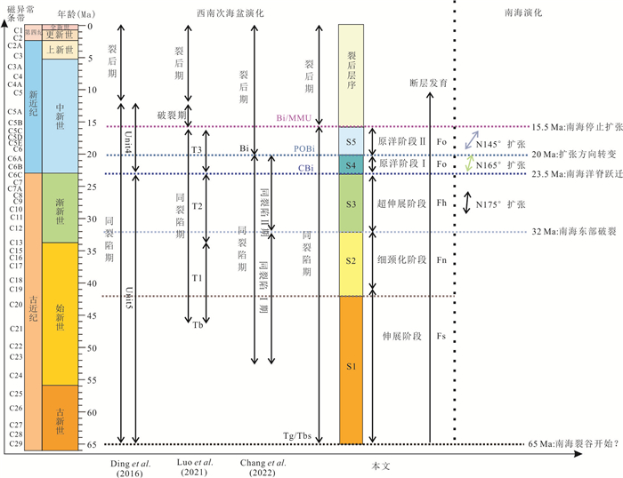
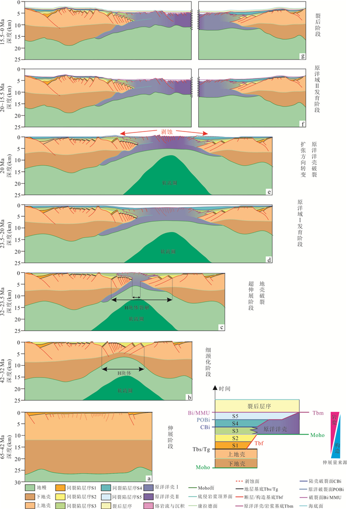
The formation and evolution mechanism of the passive rift margin under the marginal sea background is still controversial, especially existing studies on the structural characteristics and formation process of the oceanic and continental transition zone are insufficient. In order to deeply explore the tectonic structure and evolution characteristics of the rift margin and oceanic transition zone of the South China Sea (SCS) under the background of marginal sea, this study presents an investigation of the seismic profiles across the Ⅴ-shaped tip of the Southwest Sub-basin of the SCS, identifying three first order rift margin interfaces including the Moho, Top of basement, and seafloor. The tectonic units of the conjugate margin are subdivided into the necking domain, the hyper-extended domain, and the proto-oceanic domain. The study further refines the interpretation of the stratigraphic sequences and multi-phase fault systems at the conjugate margin as well as identifies the breakup unconformity surface Bi. We divide the syn-rift sequence (between Tg and Bi) into five sequence units (S1-S5), establishing a tectono-stratigraphic framework for the conjugate margin of the SW sub-basin of the SCS. The study indicates that the interface CBi between S3 and S4, as well as the interface POBi between S4 and S5, corresponds to the break-up of continental crust and proto-oceanic crustⅠ, respectively, recording important tectonic events during the rifting. Based on the analysis of fault activity and basin prototyping, we divide the evolution of the conjugate margin into four stages: stretching, necking, hyper-extending, and proto-oceanic crust developing, establishing the rift margin evolution model for the conjugate rift margin of the SW sub-basin of the SCS. This study also identifies a "crocodile-jaw" structure in the crust of the conjugate margin of the Ⅴ-shaped tip at the SW sub-basin of the SCS, recognizing two phases of proto-oceanic crust with total width of 231 km. Based on the investigation of the outer high and syn-breakup sequence (S4 and S5), we propose that the two phases of proto-oceanic crust developing correspond to two episodes of the seafloor spreading at SW sub-basin of the SCS, and that the proto-oceanic crust constitutes the oceanic-continental transition zone between the continental margin and the synchronous oceanic crust. This study reveals the mechanism of the lithospheric thinning and break-up, and the influence of episodic seafloor spreading during the ridge propagation process on the tectonic structure, stratigraphic sequence and magmatic activity. The research will significant deepen our understanding of the rifting process at the SCS, causes of oceanic-continental transition zones, and dynamic mechanisms involved in the formation of passive continental margins at the SCS.
The formation and evolution mechanism of the passive rift margin under the marginal sea background is still controversial, especially existing studies on the structural characteristics and formation process of the oceanic and continental transition zone are insufficient. In order to deeply explore the tectonic structure and evolution characteristics of the rift margin and oceanic transition zone of the South China Sea (SCS) under the background of marginal sea, this study presents an investigation of the seismic profiles across the Ⅴ-shaped tip of the Southwest Sub-basin of the SCS, identifying three first order rift margin interfaces including the Moho, Top of basement, and seafloor. The tectonic units of the conjugate margin are subdivided into the necking domain, the hyper-extended domain, and the proto-oceanic domain. The study further refines the interpretation of the stratigraphic sequences and multi-phase fault systems at the conjugate margin as well as identifies the breakup unconformity surface Bi. We divide the syn-rift sequence (between Tg and Bi) into five sequence units (S1-S5), establishing a tectono-stratigraphic framework for the conjugate margin of the SW sub-basin of the SCS. The study indicates that the interface CBi between S3 and S4, as well as the interface POBi between S4 and S5, corresponds to the break-up of continental crust and proto-oceanic crustⅠ, respectively, recording important tectonic events during the rifting. Based on the analysis of fault activity and basin prototyping, we divide the evolution of the conjugate margin into four stages: stretching, necking, hyper-extending, and proto-oceanic crust developing, establishing the rift margin evolution model for the conjugate rift margin of the SW sub-basin of the SCS. This study also identifies a "crocodile-jaw" structure in the crust of the conjugate margin of the Ⅴ-shaped tip at the SW sub-basin of the SCS, recognizing two phases of proto-oceanic crust with total width of 231 km. Based on the investigation of the outer high and syn-breakup sequence (S4 and S5), we propose that the two phases of proto-oceanic crust developing correspond to two episodes of the seafloor spreading at SW sub-basin of the SCS, and that the proto-oceanic crust constitutes the oceanic-continental transition zone between the continental margin and the synchronous oceanic crust. This study reveals the mechanism of the lithospheric thinning and break-up, and the influence of episodic seafloor spreading during the ridge propagation process on the tectonic structure, stratigraphic sequence and magmatic activity. The research will significant deepen our understanding of the rifting process at the SCS, causes of oceanic-continental transition zones, and dynamic mechanisms involved in the formation of passive continental margins at the SCS.
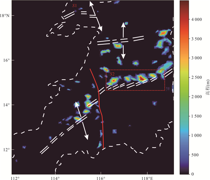
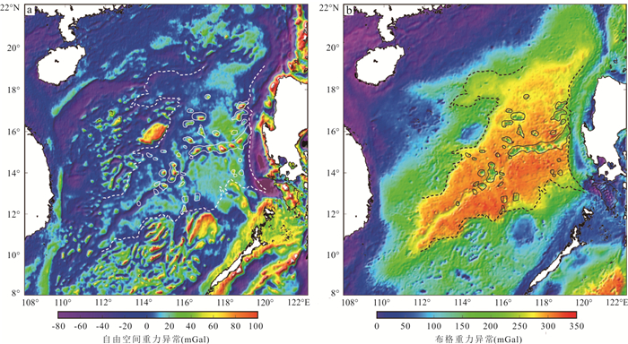
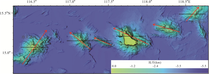
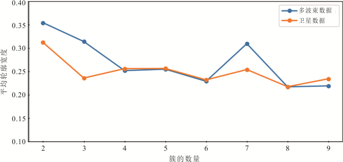
2025, 50(1): 217-233.
doi: 10.3799/dqkx.2023.218
Abstract:
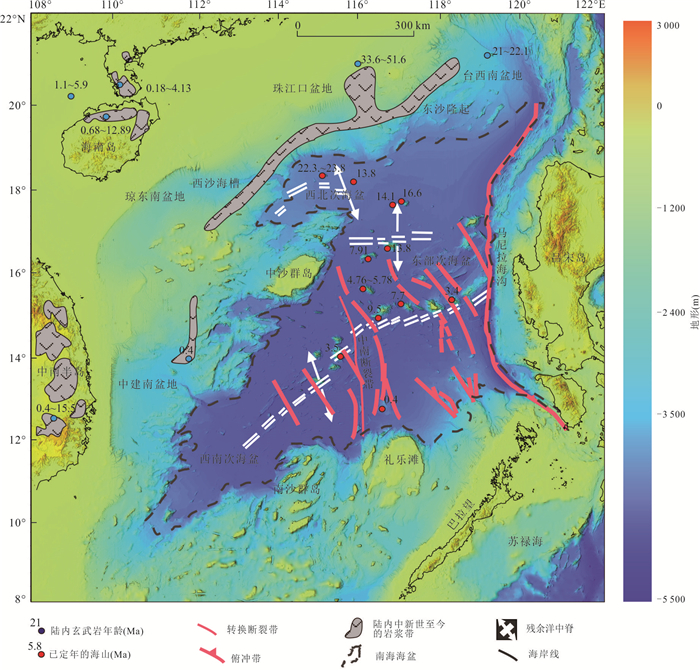
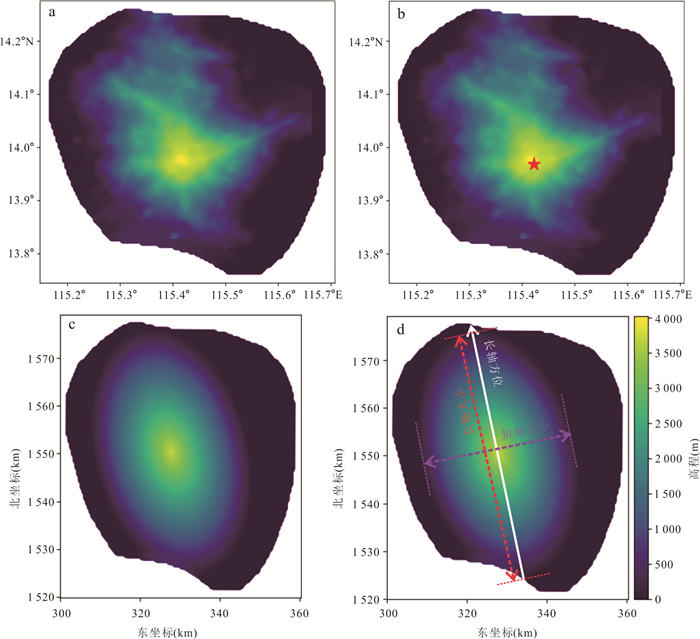
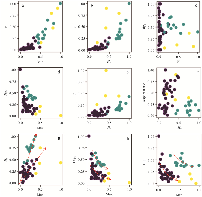
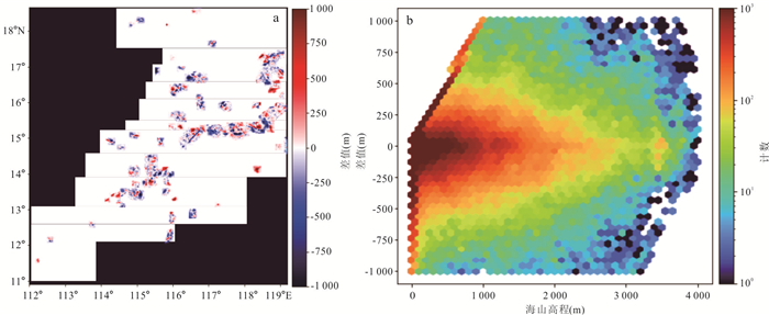
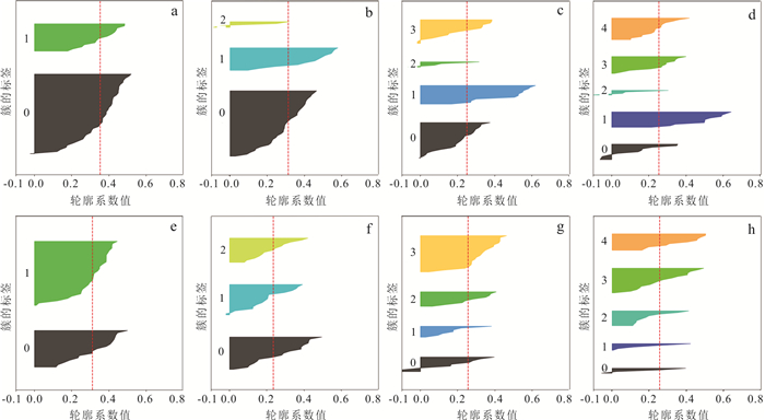
Morphological differences are evident among submarine volcanoes formed by varying eruption patterns. However, their interrelationship remains elusive due to methodological constraints. This study innovatively employs machine learning clustering analysis on high-resolution multibeam bathymetry data to quantitatively evaluate the morphological parameters of seamounts in the South China Sea Basin. The analysis discerns three distinct seamount types. Type Ⅰ: large, isolated seamounts characterized by significant volume, steep slopes, and rounded bases. Type Ⅱ: large, linear seamounts with substantial volume, gentle slopes, and elongated bases. Type Ⅲ: smaller seamounts with limited volume, gentle slopes, and elliptical bases. Type Ⅰ and Ⅱ seamounts are primarily found in the mid-ocean ridge zone of the eastern sub-basin. The pronounced morphology of Type Ⅰ suggests an active and rapid eruption regime, whereas Type Ⅱ's subdued form indicates slower volcanic activity with more fluidic lava flows. Conversely, Type Ⅲ, situated along the transform faults and distant from the mid-ocean ridge of the eastern sub-basin, signifies less intense volcanic activities. This research establishes a foundational understanding that seamount formations under distinct tectonic backgrounds follow general morphological patterns. The novel clustering approach proposed here offers fresh perspectives for probing volcanic eruption patterns, especially when extensive petrological data is not available.
Morphological differences are evident among submarine volcanoes formed by varying eruption patterns. However, their interrelationship remains elusive due to methodological constraints. This study innovatively employs machine learning clustering analysis on high-resolution multibeam bathymetry data to quantitatively evaluate the morphological parameters of seamounts in the South China Sea Basin. The analysis discerns three distinct seamount types. Type Ⅰ: large, isolated seamounts characterized by significant volume, steep slopes, and rounded bases. Type Ⅱ: large, linear seamounts with substantial volume, gentle slopes, and elongated bases. Type Ⅲ: smaller seamounts with limited volume, gentle slopes, and elliptical bases. Type Ⅰ and Ⅱ seamounts are primarily found in the mid-ocean ridge zone of the eastern sub-basin. The pronounced morphology of Type Ⅰ suggests an active and rapid eruption regime, whereas Type Ⅱ's subdued form indicates slower volcanic activity with more fluidic lava flows. Conversely, Type Ⅲ, situated along the transform faults and distant from the mid-ocean ridge of the eastern sub-basin, signifies less intense volcanic activities. This research establishes a foundational understanding that seamount formations under distinct tectonic backgrounds follow general morphological patterns. The novel clustering approach proposed here offers fresh perspectives for probing volcanic eruption patterns, especially when extensive petrological data is not available.
2025, 50(1): 234-245.
doi: 10.3799/dqkx.2023.198
Abstract:
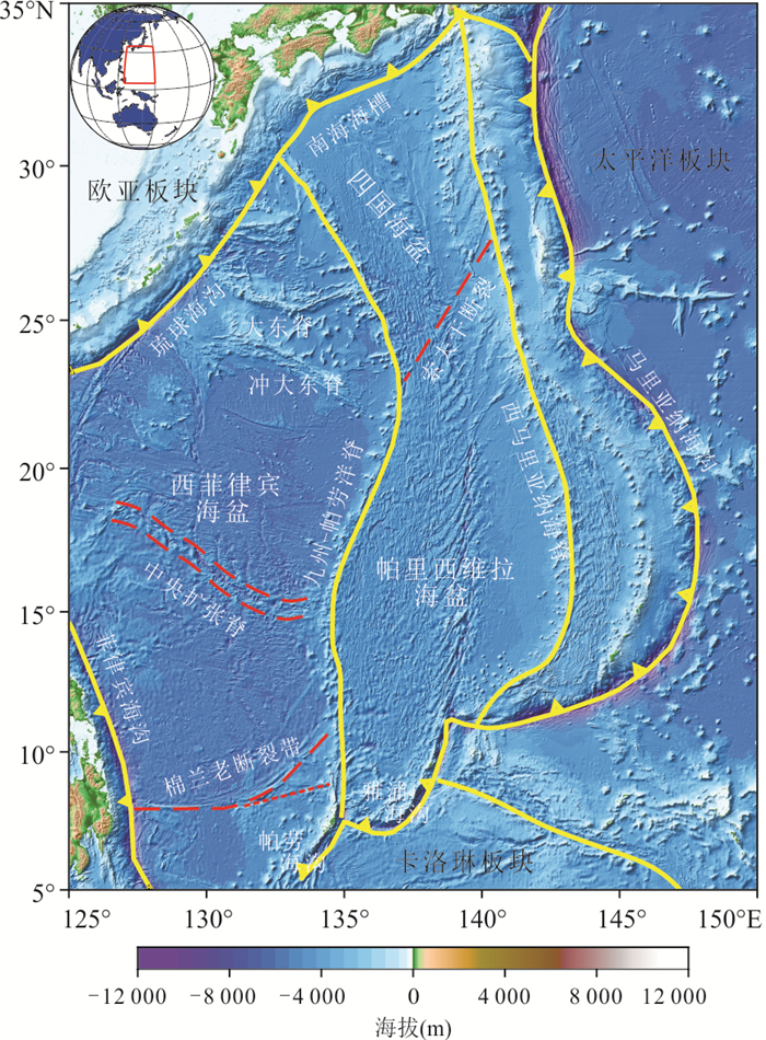
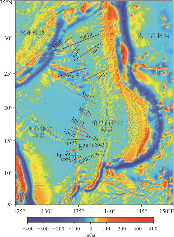
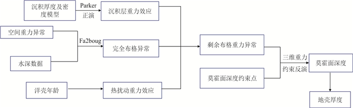
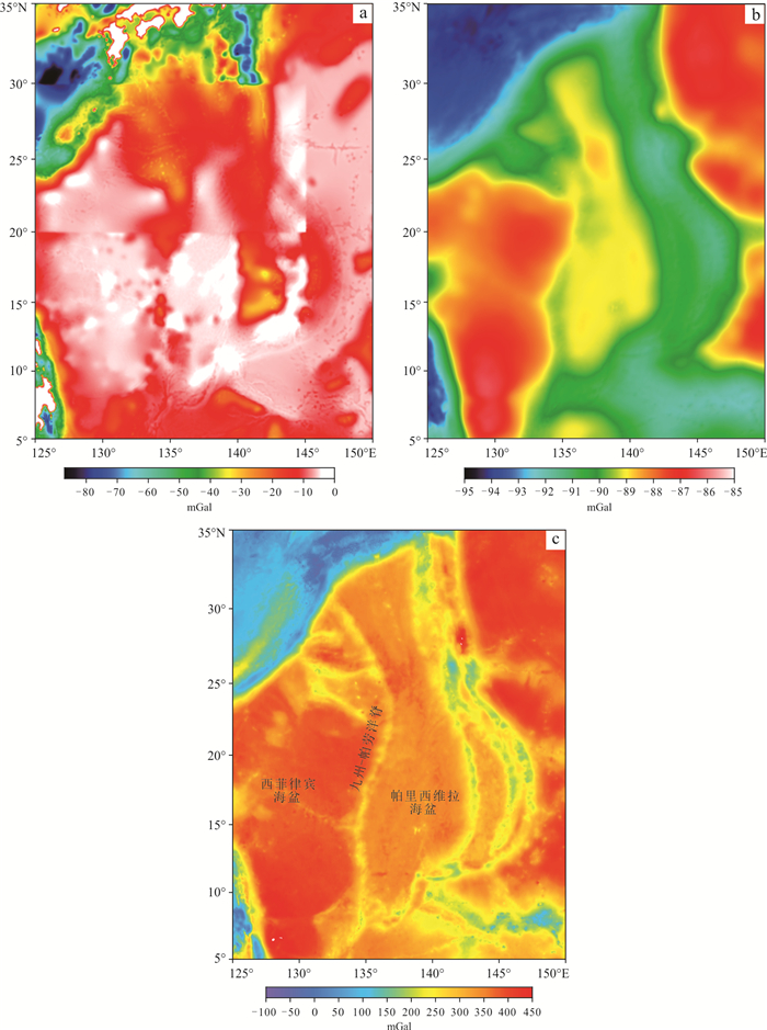
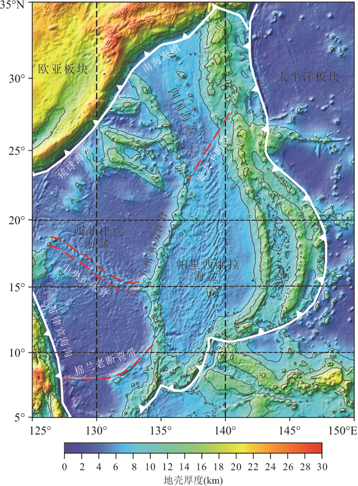
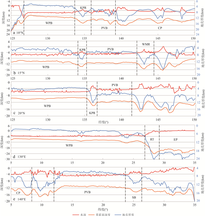
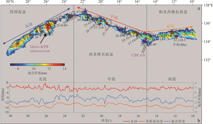
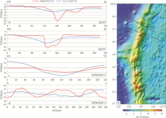
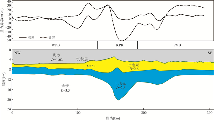
In order to understand the deep structure of the geological tectonic units of the Philippine Sea plate and the crustal feature of the Kyushu-Palau Ridge, this paper uses satellite gravity anomaly, combined with the bathymetry, sediment thickness and oceanic crust age data in the study area to correct the gravity effects of sediment and thermal disturbance. The Moho depth and crustal thickness of the Philippine Sea plate were calculated by combining Moho depth data from OBS profiles cross the KPR as constraints. The results show that the overall crustal thickness of the Philippine Sea plate is characterized by a gradual increase from west to east and from south to north. The Moho depth of the West Philippine Basin is about 10 km, with a crustal thickness of about 4 km. The average crustal thickness of the Parece Vela Basin is about 7 km, which is larger than that of the older West Philippine Basin.The crustal thickness of the Kyushu-Palau Ridge is 14 km at the maximum. In the 18°-19°N segment of the KPR, the crust is about 8 km, which is similar to the normal oceanic crust thickness in the Parece Vela Basin. There is no significant thickening crust. The crustal properties of the KPR are oceanic crust that has been thickened by back-arc magmatism, rather than mature island arc crust.
In order to understand the deep structure of the geological tectonic units of the Philippine Sea plate and the crustal feature of the Kyushu-Palau Ridge, this paper uses satellite gravity anomaly, combined with the bathymetry, sediment thickness and oceanic crust age data in the study area to correct the gravity effects of sediment and thermal disturbance. The Moho depth and crustal thickness of the Philippine Sea plate were calculated by combining Moho depth data from OBS profiles cross the KPR as constraints. The results show that the overall crustal thickness of the Philippine Sea plate is characterized by a gradual increase from west to east and from south to north. The Moho depth of the West Philippine Basin is about 10 km, with a crustal thickness of about 4 km. The average crustal thickness of the Parece Vela Basin is about 7 km, which is larger than that of the older West Philippine Basin.The crustal thickness of the Kyushu-Palau Ridge is 14 km at the maximum. In the 18°-19°N segment of the KPR, the crust is about 8 km, which is similar to the normal oceanic crust thickness in the Parece Vela Basin. There is no significant thickening crust. The crustal properties of the KPR are oceanic crust that has been thickened by back-arc magmatism, rather than mature island arc crust.
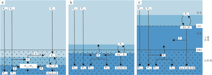
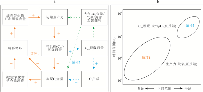
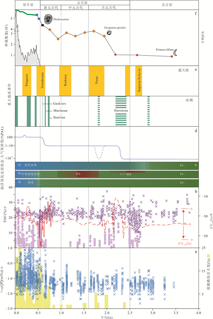
2025, 50(1): 246-268.
doi: 10.3799/dqkx.2023.202
Abstract:
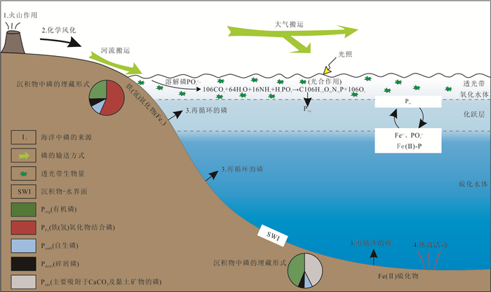
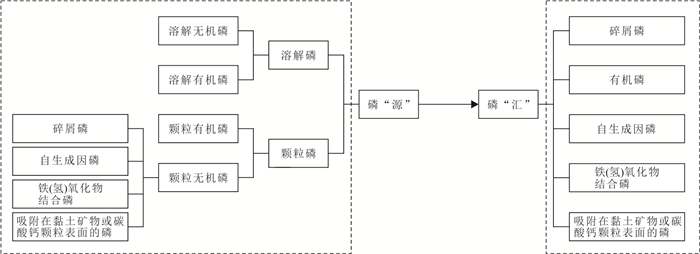
Phosphorus (P), as a central component of DNA and RNA of life on earth, is the major limiting nutrient for marine productivity on geological time scales, and plays an important role in regulating the global atmosphere-ocean redox state and Earth's climate. This paper summarizes the source and sink of P in the ocean, and expounds the composition of P speciation and its application in the study of P burial, diagenetic transformations and marine P cycle, and analyzes the sedimentary P characteristics in the ancient strata and their links with life-environment evolution, which helps clarify features and mechanism of P cycling in different geological periods and its feedback on atmosphere-ocean-ecology system. This is of far-reaching significance for understanding the relationship between life and Earth's environment.
Phosphorus (P), as a central component of DNA and RNA of life on earth, is the major limiting nutrient for marine productivity on geological time scales, and plays an important role in regulating the global atmosphere-ocean redox state and Earth's climate. This paper summarizes the source and sink of P in the ocean, and expounds the composition of P speciation and its application in the study of P burial, diagenetic transformations and marine P cycle, and analyzes the sedimentary P characteristics in the ancient strata and their links with life-environment evolution, which helps clarify features and mechanism of P cycling in different geological periods and its feedback on atmosphere-ocean-ecology system. This is of far-reaching significance for understanding the relationship between life and Earth's environment.
2025, 50(1): 269-285.
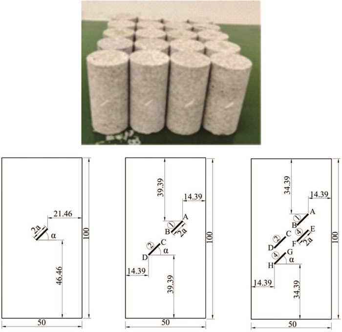
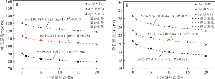
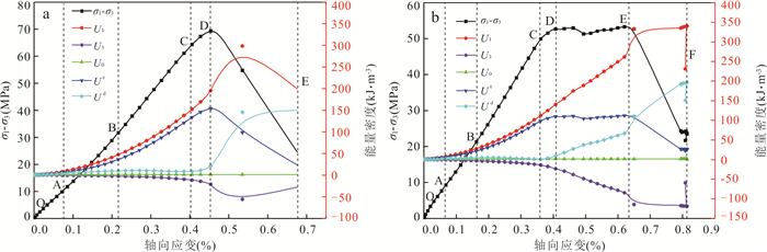
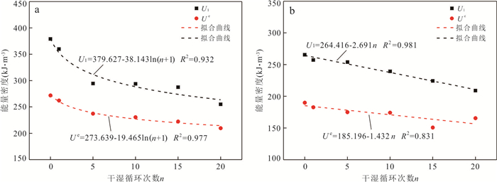
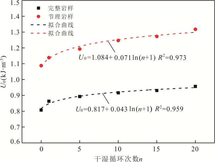
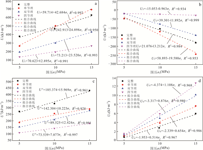
doi: 10.3799/dqkx.2023.023
Abstract:
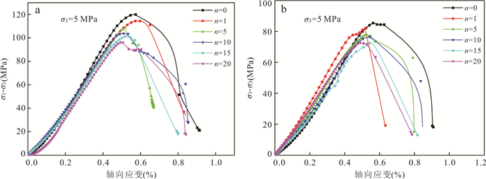
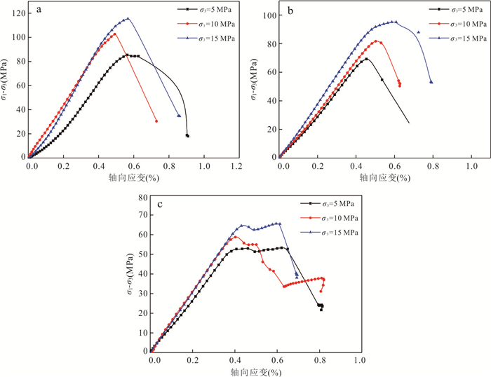
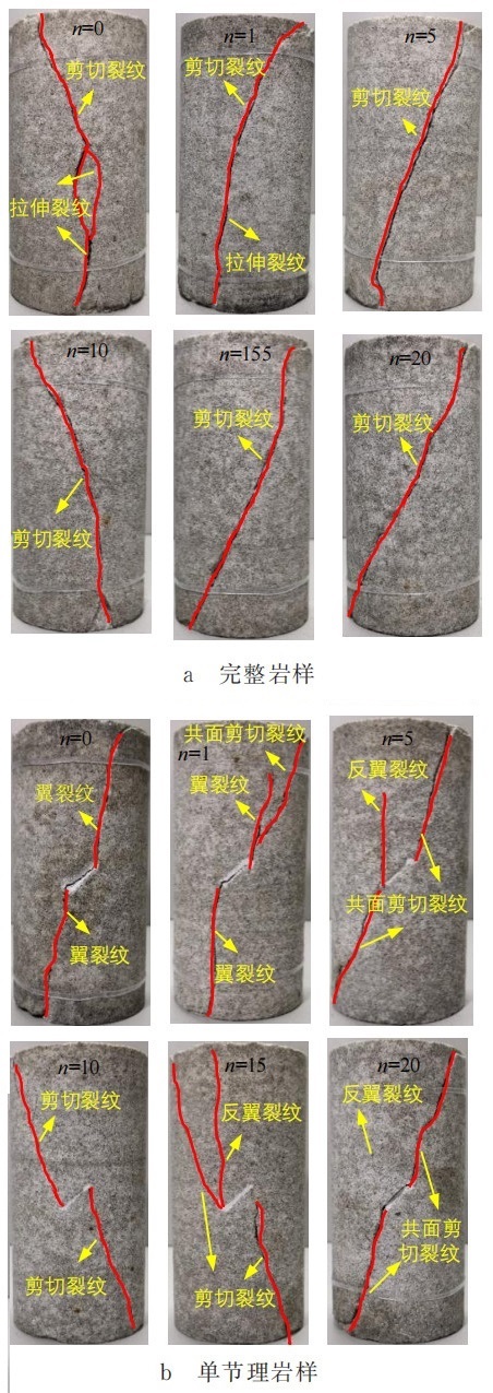
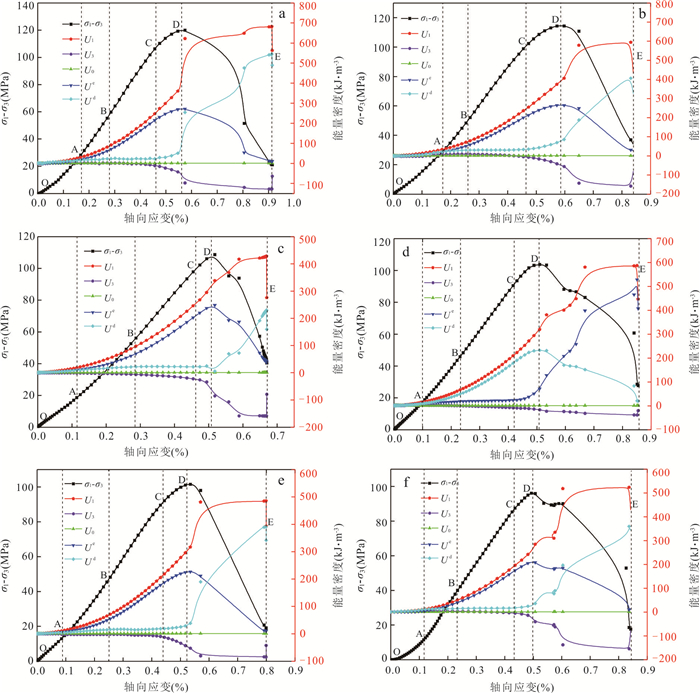
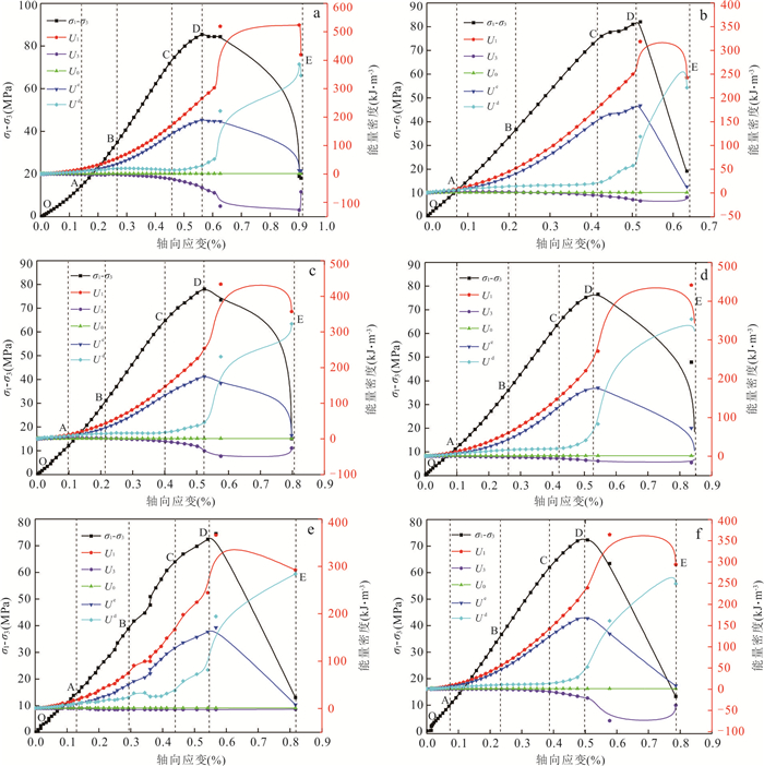
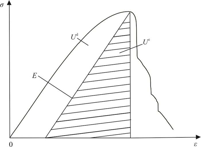
In order to explore the energy dissipation mechanism of damage and failure of jointed sandstone under dry-wet cycling conditions, the triaxial compression test and rock energy dissipation theory were adopted to study the energy conversion law and the energy-driven mechanism during the deformation and failure process. The results show that the input energy U1 from the axial pressure and the elastic strain energy Ue decrease gradually with the increase of cycles of dry-wet cycling. Specifically, the logarithmic and the linear trends were observed for the intact rock sample and the jointed rock sample, respectively. According to the evolution law of dissipated energy, the energy damage process of jointed sandstone under the loading is divided into five stages: initial damage, stable damage, stationary damage, accelerated damage and damage failure according to evolution law of dissipated energy during the process of deformation. In addition, with the increase of confining pressure, U1 and Ue at the peak point increase linearly, the strain energy U3 done by confining pressure and the energy U0 absorbed by hydrostatic pressure decrease and increase linearly, respectively. The dry-wet cycling will reduce the minimum activation energy of microcrack propagation, weakening the elastic strain energy stored in the rock. This is the essential reason for the strength weakening of jointed sandstone under dry-wet cycling.
In order to explore the energy dissipation mechanism of damage and failure of jointed sandstone under dry-wet cycling conditions, the triaxial compression test and rock energy dissipation theory were adopted to study the energy conversion law and the energy-driven mechanism during the deformation and failure process. The results show that the input energy U1 from the axial pressure and the elastic strain energy Ue decrease gradually with the increase of cycles of dry-wet cycling. Specifically, the logarithmic and the linear trends were observed for the intact rock sample and the jointed rock sample, respectively. According to the evolution law of dissipated energy, the energy damage process of jointed sandstone under the loading is divided into five stages: initial damage, stable damage, stationary damage, accelerated damage and damage failure according to evolution law of dissipated energy during the process of deformation. In addition, with the increase of confining pressure, U1 and Ue at the peak point increase linearly, the strain energy U3 done by confining pressure and the energy U0 absorbed by hydrostatic pressure decrease and increase linearly, respectively. The dry-wet cycling will reduce the minimum activation energy of microcrack propagation, weakening the elastic strain energy stored in the rock. This is the essential reason for the strength weakening of jointed sandstone under dry-wet cycling.
2025, 50(1): 286-298.
doi: 10.3799/dqkx.2023.206
Abstract:
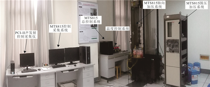
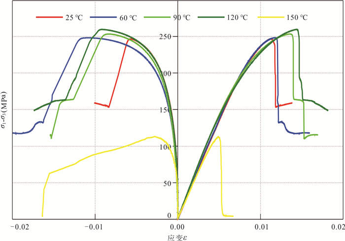
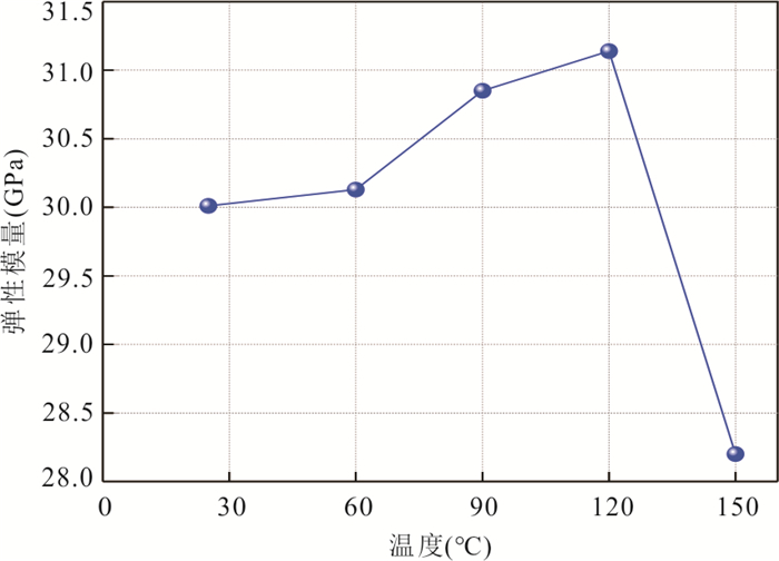
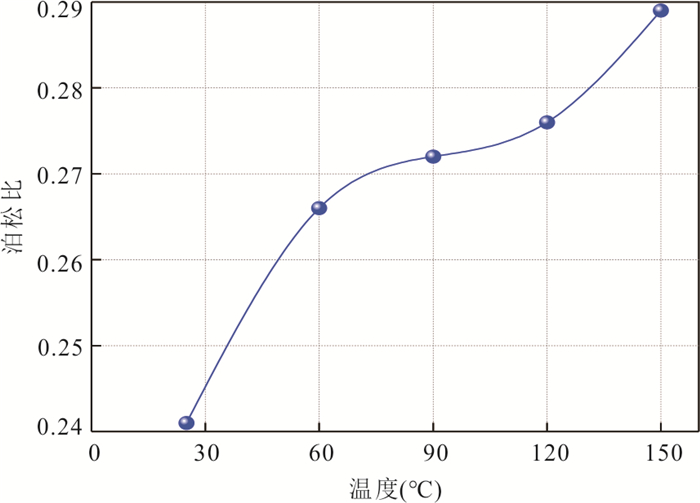
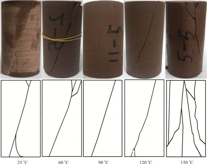
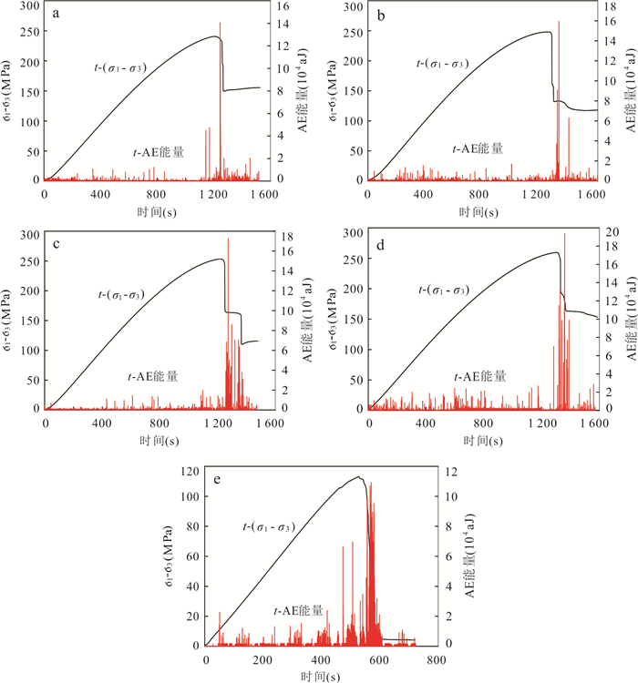
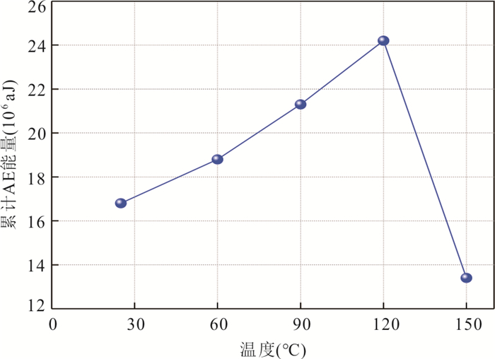
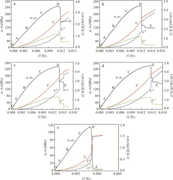
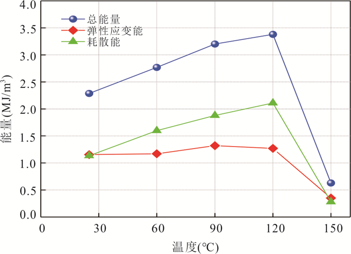
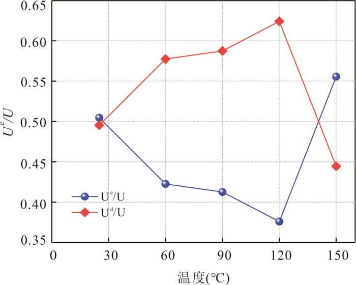
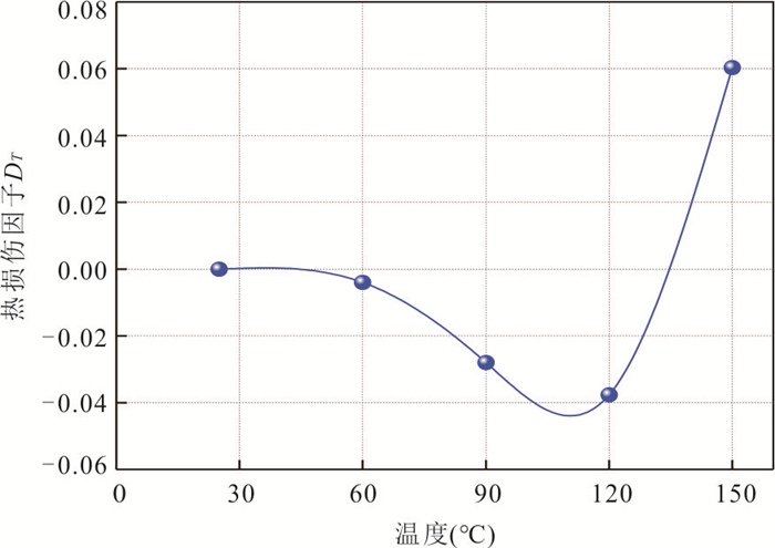
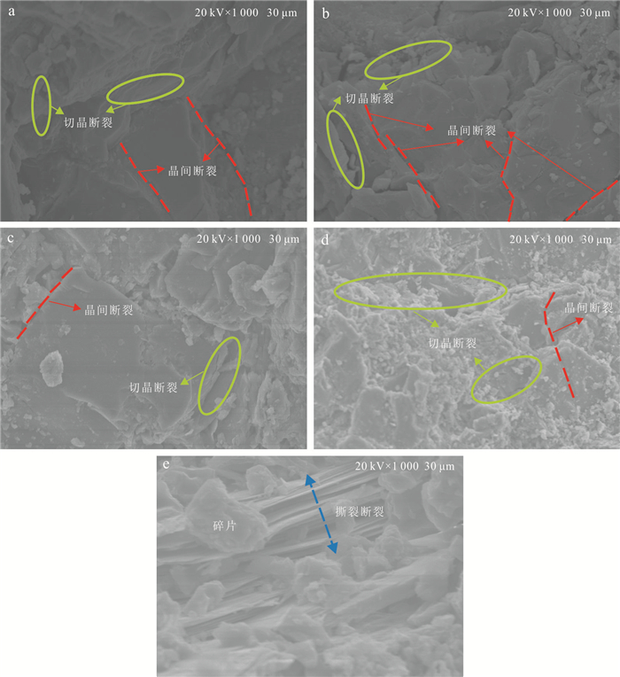
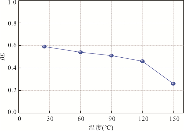
The damage and energy evolution characteristics of rocks under real-time high temperature are hot and difficult issues in deep geological engineering. MTS815 program-controlled servo rigid testing machine and PCI-Ⅱ acoustic emission instrument were used for triaxial compression tests of sandstone under real-time high temperatures in this study, and the mechanical and energy characteristics of sandstone under high temperature were analyzed and discussed based on the test results and introducing the law of energy consumption evolution. The results show that: (1) There is a temperature threshold between 120 ℃ and 150 ℃, which leads to thermal damage inside sandstone, and its peak strength is greatly reduced, and the macroscopic failure form is transformed from shear failure to tensile failure. (2) When the temperature is between 20 ℃ and 120 ℃, the accumulated AE energy, stored energy and released energy of sandstone increase with the increase of temperature; and when the temperature is 150 ℃, thermal damage occurs inside sandstone. Ac cumulative AE energy, energy storage capacity and energy release capacity were significantly reduced. (3) The brittleness index of rock BE decreases with the increase of temperature. At the temperature of 120-150 ℃, the sandstone BE value decreases greatly from about 0.5 to 0.26, showing obvious plastic characteristics. The influence of temperature on the mechanical properties, failure mode, acoustic emission activity, strain energy evolution process and brittle state of sandstone is systematically analyzed. It is found that there is an obvious temperature threshold, which changes all kinds of behaviors of sandstone obviously before and after the threshold.
The damage and energy evolution characteristics of rocks under real-time high temperature are hot and difficult issues in deep geological engineering. MTS815 program-controlled servo rigid testing machine and PCI-Ⅱ acoustic emission instrument were used for triaxial compression tests of sandstone under real-time high temperatures in this study, and the mechanical and energy characteristics of sandstone under high temperature were analyzed and discussed based on the test results and introducing the law of energy consumption evolution. The results show that: (1) There is a temperature threshold between 120 ℃ and 150 ℃, which leads to thermal damage inside sandstone, and its peak strength is greatly reduced, and the macroscopic failure form is transformed from shear failure to tensile failure. (2) When the temperature is between 20 ℃ and 120 ℃, the accumulated AE energy, stored energy and released energy of sandstone increase with the increase of temperature; and when the temperature is 150 ℃, thermal damage occurs inside sandstone. Ac cumulative AE energy, energy storage capacity and energy release capacity were significantly reduced. (3) The brittleness index of rock BE decreases with the increase of temperature. At the temperature of 120-150 ℃, the sandstone BE value decreases greatly from about 0.5 to 0.26, showing obvious plastic characteristics. The influence of temperature on the mechanical properties, failure mode, acoustic emission activity, strain energy evolution process and brittle state of sandstone is systematically analyzed. It is found that there is an obvious temperature threshold, which changes all kinds of behaviors of sandstone obviously before and after the threshold.
2025, 50(1): 299-310.
doi: 10.3799/dqkx.2024.074
Abstract:
Various tectonic phenomena occurring on and beneath the Earth's surface, and the associated geological disasters, are closely related to regional stress fields. However, the quantitative relationship between regional stress fields and landslide density or size is not yet clear. This paper utilizes a high-resolution three-dimensional stress field model that accounts for fault and topographic influences, combined with rock damage data, to analyze the relationship between the size and density of rock landslides and different stress parameters before and after the Luding Ms6.8 earthquake on September 5, 2022. The results indicate that stress field shows a strong correlation with rock landslides. A significant positive correlation exists between the maximum shear stress and both the upper area limit and density of rock landslides. Areas of high maximum shear stress align closely with the spatial distribution of rock landslides before and after the earthquake, with over 90% of the landslides occurring above a threshold of 6.95 MPa in maximum shear stress. The stress fields, disturbed by topography and faults, control the development of structural planes in the rock, creating the necessary material conditions for the formation of rock landslides. This study emphasizes that the occurrence of rock landslides is not merely a simple process triggered by random factors, but a complex process influenced by ground stress, topography, and geological structures.
Various tectonic phenomena occurring on and beneath the Earth's surface, and the associated geological disasters, are closely related to regional stress fields. However, the quantitative relationship between regional stress fields and landslide density or size is not yet clear. This paper utilizes a high-resolution three-dimensional stress field model that accounts for fault and topographic influences, combined with rock damage data, to analyze the relationship between the size and density of rock landslides and different stress parameters before and after the Luding Ms6.8 earthquake on September 5, 2022. The results indicate that stress field shows a strong correlation with rock landslides. A significant positive correlation exists between the maximum shear stress and both the upper area limit and density of rock landslides. Areas of high maximum shear stress align closely with the spatial distribution of rock landslides before and after the earthquake, with over 90% of the landslides occurring above a threshold of 6.95 MPa in maximum shear stress. The stress fields, disturbed by topography and faults, control the development of structural planes in the rock, creating the necessary material conditions for the formation of rock landslides. This study emphasizes that the occurrence of rock landslides is not merely a simple process triggered by random factors, but a complex process influenced by ground stress, topography, and geological structures.
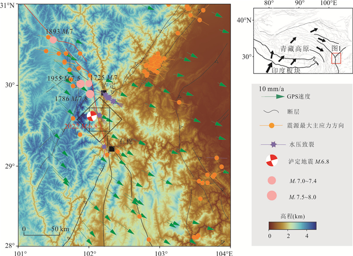
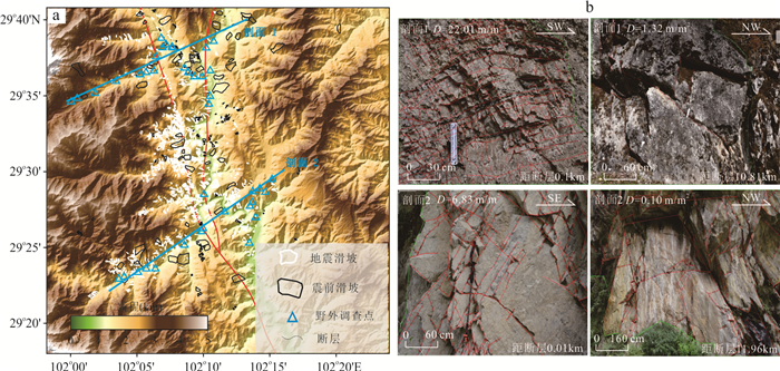
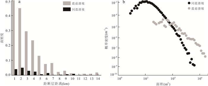
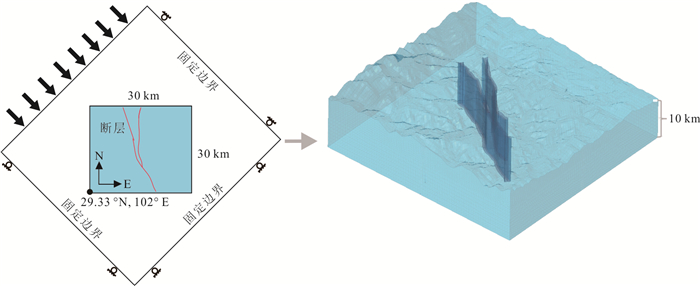
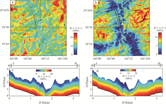
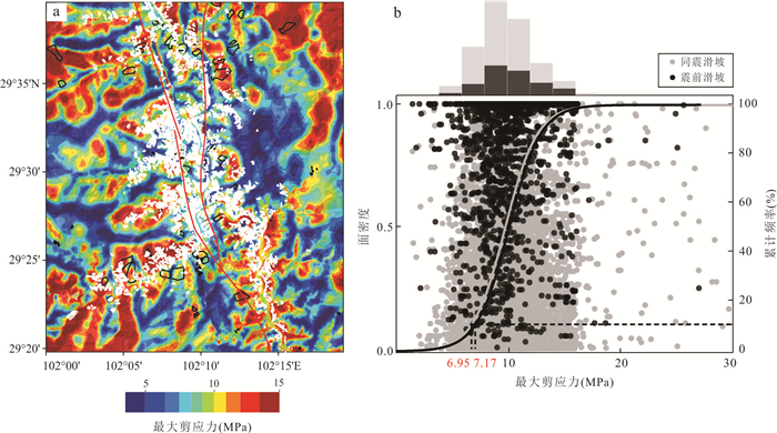
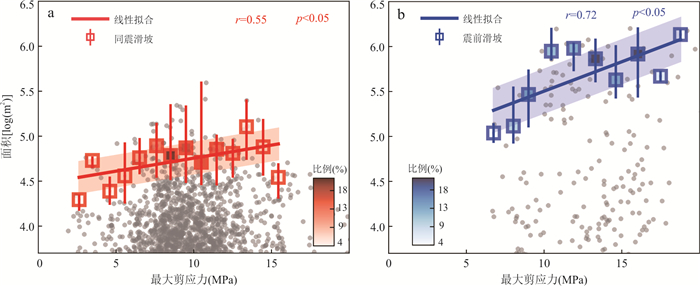
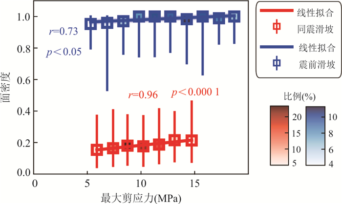
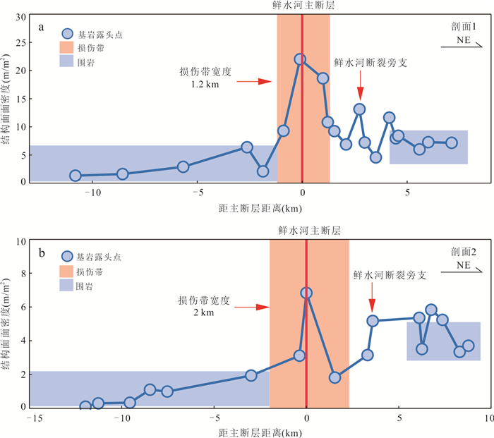
2025, 50(1): 311-321.
doi: 10.3799/dqkx.2023.170
Abstract:
The occurrence of landslide is mainly caused by rainfall. Traditional treatment methods, such as spraying concrete on the surface of landslide to inhibit the penetration of rainfall on soil slopes, will fail during long-term operation resulted from failures, leading to landslides. Therefore, considering the ecological function and the long-term effectiveness of the reclamation method, this paper adopts the dual-structure of unsaturated capillary barrier layer (CBL) with fine/coarse lithology to prevent rainfall from infiltrating into the soil slope. The effects of slope (10°, 20°, 30°, 40°) and lithological characteristics (sandy loam/coarse sand, sandy loam/gravel sand, sandy loam/pebble and sandy loam/breccia) on the infiltration of rainfall into the soil slope were investigated through a series of physical model tests. Furthermore, a new method is defined to evaluate the total capacity of the capillary barrier (CCB) of the fine/coarse bilayer. The research results show that: (1) The process of preventing rainfall from infiltrating the soil slope with brilliant blue FCF (C.I.42090) dye tracer can be observed visually. (2) CCBS increases with the increase of coarse particle diameter, which is also related to the shape of pores and coarse particles, that is, the drainage efficiency of breccia with the same particle composition is higher than that of boulders. (3) The larger the slope angle of the four types of CBLS soil, the higher the drainage speed of CBL after rainfall, and the stable drainage strength and the total barrier capacity of loam/gravel sand CBL with rainfall intensity of 4.73×10⁻⁴ cm/s, could increase firstly and then decrease with the increased slope angles. It is suggested that the design slope of CBLS is 25°-27°, in order to achieve the optimal total barrier capacity. The results of this study have a certain reference value for future landslide control.
The occurrence of landslide is mainly caused by rainfall. Traditional treatment methods, such as spraying concrete on the surface of landslide to inhibit the penetration of rainfall on soil slopes, will fail during long-term operation resulted from failures, leading to landslides. Therefore, considering the ecological function and the long-term effectiveness of the reclamation method, this paper adopts the dual-structure of unsaturated capillary barrier layer (CBL) with fine/coarse lithology to prevent rainfall from infiltrating into the soil slope. The effects of slope (10°, 20°, 30°, 40°) and lithological characteristics (sandy loam/coarse sand, sandy loam/gravel sand, sandy loam/pebble and sandy loam/breccia) on the infiltration of rainfall into the soil slope were investigated through a series of physical model tests. Furthermore, a new method is defined to evaluate the total capacity of the capillary barrier (CCB) of the fine/coarse bilayer. The research results show that: (1) The process of preventing rainfall from infiltrating the soil slope with brilliant blue FCF (C.I.42090) dye tracer can be observed visually. (2) CCBS increases with the increase of coarse particle diameter, which is also related to the shape of pores and coarse particles, that is, the drainage efficiency of breccia with the same particle composition is higher than that of boulders. (3) The larger the slope angle of the four types of CBLS soil, the higher the drainage speed of CBL after rainfall, and the stable drainage strength and the total barrier capacity of loam/gravel sand CBL with rainfall intensity of 4.73×10⁻⁴ cm/s, could increase firstly and then decrease with the increased slope angles. It is suggested that the design slope of CBLS is 25°-27°, in order to achieve the optimal total barrier capacity. The results of this study have a certain reference value for future landslide control.

2025, 50(1): 322-335.
doi: 10.3799/dqkx.2023.015
Abstract:
The mechanism of soil strength deterioration caused by the melting of buried ice in glacier tills formed since the Little Ice Age under the climate warming and humidification is of great significance for deeply comprehending the initiation process of glacier debris flow. Taking the soil from the source of Tianmo gully debris flow in Parlung Tsangpo Basin as the research object, the high-precision temperature control triaxial coupling experimental system was used to study the shear deformation characteristics of glacier tills under different temperature conditions, analyze the influence mechanism of temperature on deformation and failure, and construct the strength failure criterion of this multiphase medium. The results show that the deformation and failure of glacier tills were significantly affected by temperature. At -20 ℃, the glacier tills showed strain softening and shear band failure characteristics, and the glacier tills gradually exhibited strain hardening and bulging failure characteristics with the increasing temperature. The modulus, peak shear strength, internal friction angle and cohesion decreased with the increase of temperature, and the rate was fastest at -3 to -5 ℃, while the brittleness index increased with temperature increasing. Boltzmann function was introduced to describe the relationship between shear strength parameters and temperature. Analyses show that the critical temperature of shear strength parameter variation was around -4 ℃. The strength failure criterion of glacier tills containing temperature parameters was constructed based on Mohr-Coulomb theory. Compared with frozen soil containing pore ice, the strength of glacier tills which contain buried ice is mainly provided by the contact between particles, which is easier to be affected by the change of external temperature, and the response of strength to temperature is more complex.
The mechanism of soil strength deterioration caused by the melting of buried ice in glacier tills formed since the Little Ice Age under the climate warming and humidification is of great significance for deeply comprehending the initiation process of glacier debris flow. Taking the soil from the source of Tianmo gully debris flow in Parlung Tsangpo Basin as the research object, the high-precision temperature control triaxial coupling experimental system was used to study the shear deformation characteristics of glacier tills under different temperature conditions, analyze the influence mechanism of temperature on deformation and failure, and construct the strength failure criterion of this multiphase medium. The results show that the deformation and failure of glacier tills were significantly affected by temperature. At -20 ℃, the glacier tills showed strain softening and shear band failure characteristics, and the glacier tills gradually exhibited strain hardening and bulging failure characteristics with the increasing temperature. The modulus, peak shear strength, internal friction angle and cohesion decreased with the increase of temperature, and the rate was fastest at -3 to -5 ℃, while the brittleness index increased with temperature increasing. Boltzmann function was introduced to describe the relationship between shear strength parameters and temperature. Analyses show that the critical temperature of shear strength parameter variation was around -4 ℃. The strength failure criterion of glacier tills containing temperature parameters was constructed based on Mohr-Coulomb theory. Compared with frozen soil containing pore ice, the strength of glacier tills which contain buried ice is mainly provided by the contact between particles, which is easier to be affected by the change of external temperature, and the response of strength to temperature is more complex.
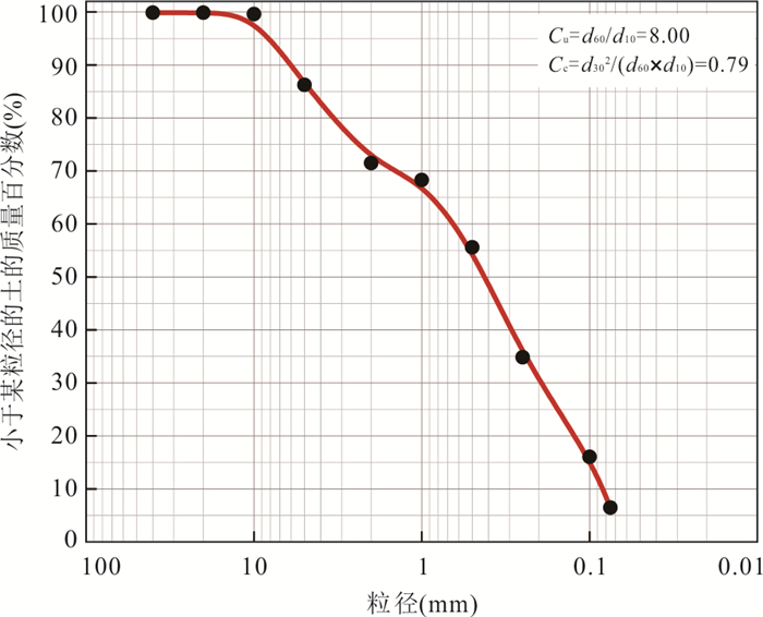
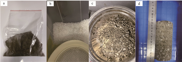
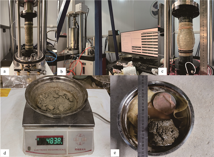
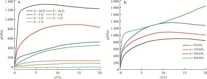
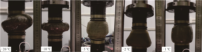
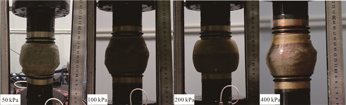
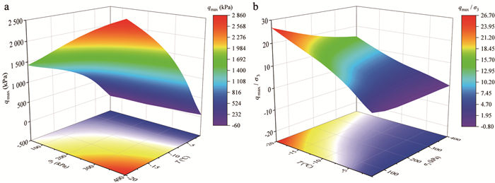
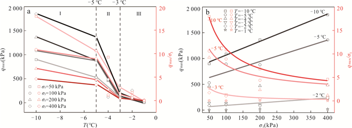
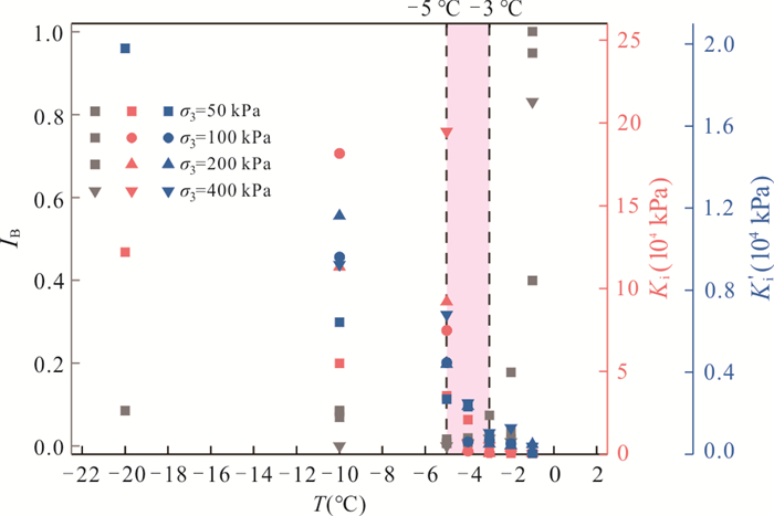
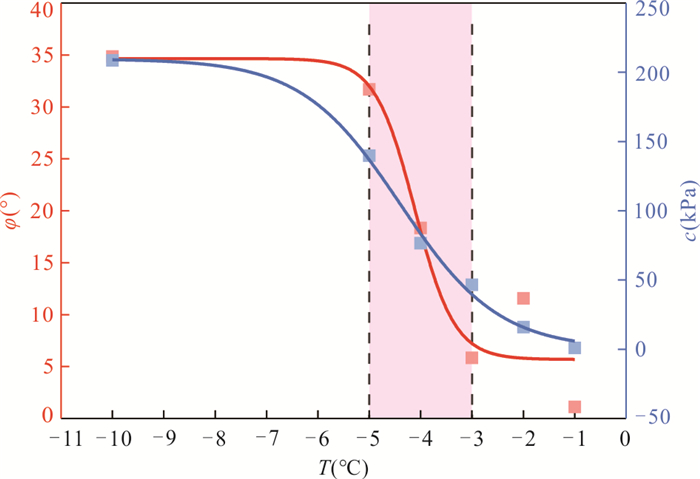
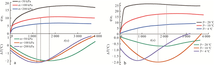
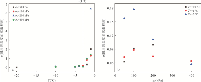
2025, 50(1): 336-348.
doi: 10.3799/dqkx.2022.172
Abstract:
The Xianshuihe-Xiaojiang fault zone diverges into several SN-trending branch faults in central Yunnan, among which the Puduhe fault has triggered earthquakes of magnitude more than 5 for many times, but its spatial distribution characteristics of tectonic activity are not clear. Because geomorphic index is very sensitive to tectonic activity, it can well indicate the distribution characteristics of tectonic activity. In order to study the distribution characteristics of tectonic activity of the Purduhe fault, 41 basins in the Purduhe fault region were extracted by using digital elevation model (DEM) with a resolution of 30 m. The basin is divided into three sections: north section (Sayingpan-Fumin Section), middle section (Fumin-Jinning Section) and south section (Jinning-Eshan Section). Seven geomorphic indices including hypsometric curve and hypsometric integral (HI), asymmetric factor (AF), basin shape index (BS), the ratio of valley floor width to valley height (VF), normalized stream-length gradient (SLK), sinuosity of the mountain front (Smf) and the steepness index(Ksn)were obtained through analysis. The results show that the spatial variation characteristics of geomorphic indices of the Puduhe fault are not affected by non-structural factors (precipitation and lithology), but they are mainly affected by tectonic activities. The relative tectonic activity of the Puduhe fault gradually decreases from north to south, and the tectonic activity of the east side of the fault is slightly weaker than that of the west side. The structural activity of the Puduhe fault is weaker than that of the Xiaojiang fault, indicating that during the extrusion process of the Sichuan-Yunnan block, the highly active area is mainly concentrated in the boundary fault zone.
The Xianshuihe-Xiaojiang fault zone diverges into several SN-trending branch faults in central Yunnan, among which the Puduhe fault has triggered earthquakes of magnitude more than 5 for many times, but its spatial distribution characteristics of tectonic activity are not clear. Because geomorphic index is very sensitive to tectonic activity, it can well indicate the distribution characteristics of tectonic activity. In order to study the distribution characteristics of tectonic activity of the Purduhe fault, 41 basins in the Purduhe fault region were extracted by using digital elevation model (DEM) with a resolution of 30 m. The basin is divided into three sections: north section (Sayingpan-Fumin Section), middle section (Fumin-Jinning Section) and south section (Jinning-Eshan Section). Seven geomorphic indices including hypsometric curve and hypsometric integral (HI), asymmetric factor (AF), basin shape index (BS), the ratio of valley floor width to valley height (VF), normalized stream-length gradient (SLK), sinuosity of the mountain front (Smf) and the steepness index(Ksn)were obtained through analysis. The results show that the spatial variation characteristics of geomorphic indices of the Puduhe fault are not affected by non-structural factors (precipitation and lithology), but they are mainly affected by tectonic activities. The relative tectonic activity of the Puduhe fault gradually decreases from north to south, and the tectonic activity of the east side of the fault is slightly weaker than that of the west side. The structural activity of the Puduhe fault is weaker than that of the Xiaojiang fault, indicating that during the extrusion process of the Sichuan-Yunnan block, the highly active area is mainly concentrated in the boundary fault zone.
2025, 50(1): 349-360.
doi: 10.3799/dqkx.2023.192
Abstract:
In the process of CO2 geological storage, in order to explore the influence of fracture network orientations on the two-phase transport of CO2-salt water in the caprock and evaluate the sealing performance of the caprock, six fracture networks with different orientations (with angles of 0°-180°, 30°-150°, 45°-135°, 60°-120°, 90°-90° and 90°-180°, respectively) were selected for numerical simulation, so as to realize the two-phase flow study of CO2 displacement of salt water under explicit fracture network. It is found that the fracture network orientations directly change the occurrence of water saturation, thereby affecting the difficulty of CO2-salt water displacement. When CO2 reaches the same penetration depth in the caprock, the displacement time decreased by 12.59 times with the fracture angle (0°-60°), but there is no obvious effect after the inclination angle increased to 60°. With the expansion of the permeability range of the fracture network, the permeability of CO2 in the caprock increases. Among them, orthogonal fractures (90°-180°) have the largest permeability. Therefore, considering the fracture network direction is of great significance for the caprock sealing evaluation.
In the process of CO2 geological storage, in order to explore the influence of fracture network orientations on the two-phase transport of CO2-salt water in the caprock and evaluate the sealing performance of the caprock, six fracture networks with different orientations (with angles of 0°-180°, 30°-150°, 45°-135°, 60°-120°, 90°-90° and 90°-180°, respectively) were selected for numerical simulation, so as to realize the two-phase flow study of CO2 displacement of salt water under explicit fracture network. It is found that the fracture network orientations directly change the occurrence of water saturation, thereby affecting the difficulty of CO2-salt water displacement. When CO2 reaches the same penetration depth in the caprock, the displacement time decreased by 12.59 times with the fracture angle (0°-60°), but there is no obvious effect after the inclination angle increased to 60°. With the expansion of the permeability range of the fracture network, the permeability of CO2 in the caprock increases. Among them, orthogonal fractures (90°-180°) have the largest permeability. Therefore, considering the fracture network direction is of great significance for the caprock sealing evaluation.