2024 Vol. 49, No. 6
Display Method:
2024, 49(6): 1931-1945.
doi: 10.3799/dqkx.2024.016
 PDF 10826KB
Abstract:
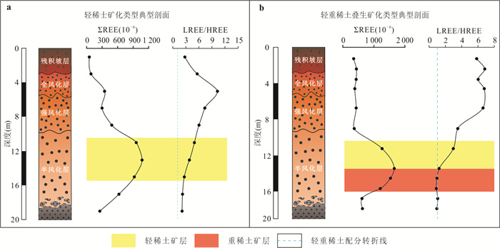
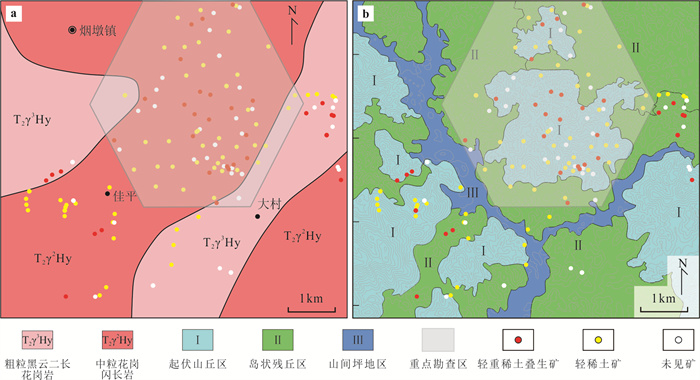
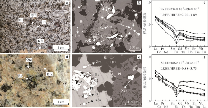
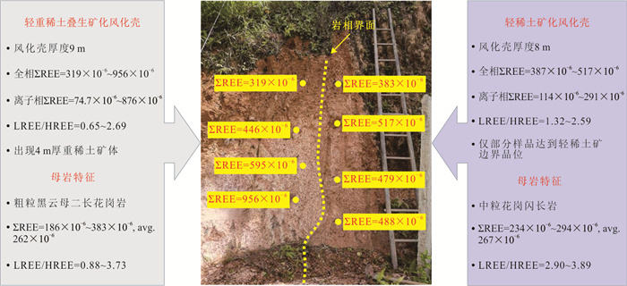
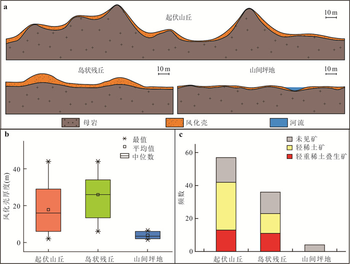
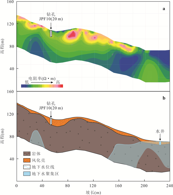
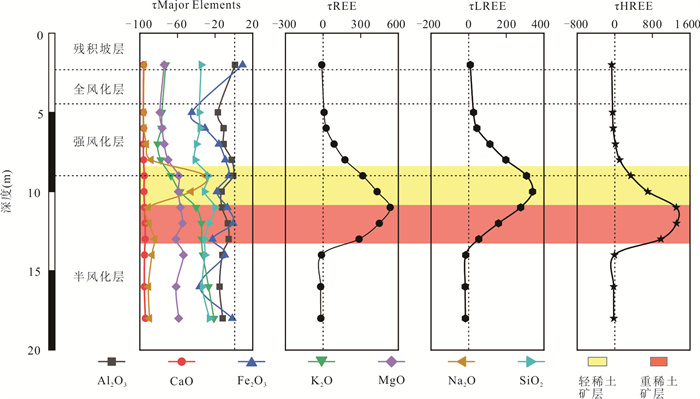
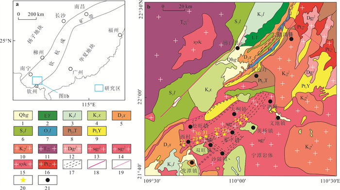
The ion-adsorption type REE deposit is a critical mineral resource in China that has a great impact on international REE supply. Guangxi, as one of the major provinces in southern China that developing the ion-adsorption type REE, has numerous deposits and abundant reserves. However, when examining the mineralization classification, the majority of the REE deposits in Guangxi is categorized as LREE-type, with fewer of the HREE-type. To bolster Guangxi's reserves of HREE, it conducted a wide screening of potential prospecting directions and proposed that a newly reported LREE+HREE overlapping type deposit could serve as a breakthrough target. Furthermore, it selected a demonstration district located in Jiaping, Lingshan County, to conduct integrated work encompassing both scientific research and mineral exploration. The results reveal that, in addition to the common LREE-type mineralization, the LREE+HREE overlapping-type mineralization is also found in the demonstration district, characterized by a dual-layer mineralization structure with "upper LREE ore and lower HREE ore". Both two mineralization types share similar parent rock conditions, which are associated with medium to coarse-grained biotite monzonitic-granodioritic granite with high total REE content (ΣREE > 260×10-6), low to moderate LREE distribution (1 < LREE/HREE < 4), and rich in easily weathered REE-bearing accessory minerals. However, compared to the LREE-type, the LREE+HREE overlapping-type tends to be developed in some special geomorphological-hydrological locations, where thick regolith and strong soil water infiltration exist. This preferred exogenous environment could provide more favorable spatial and dynamic conditions for the happening of long-distance migration of REE, enhancing the differentiation effect between LREE and HREE due to their different behaviors. More mobile HREE, compared to LREE, tend to migrate to the lower part of the regolith profile, ultimately giving rise to the "upper LREE ore and lower HREE ore" dual-layer mineralization structure. Guided by the ore-forming theory mentioned above, it adjusted the conventional prospecting methods through diluting exploration spacing overall and increasing drilling validation locally, which enable to have yielded substantial practical progress. The discovery of HREE resources has reached a medium-sized scale, making it a good reference case for guiding HREE exploration not only in Guangxi but throughout South China.
The ion-adsorption type REE deposit is a critical mineral resource in China that has a great impact on international REE supply. Guangxi, as one of the major provinces in southern China that developing the ion-adsorption type REE, has numerous deposits and abundant reserves. However, when examining the mineralization classification, the majority of the REE deposits in Guangxi is categorized as LREE-type, with fewer of the HREE-type. To bolster Guangxi's reserves of HREE, it conducted a wide screening of potential prospecting directions and proposed that a newly reported LREE+HREE overlapping type deposit could serve as a breakthrough target. Furthermore, it selected a demonstration district located in Jiaping, Lingshan County, to conduct integrated work encompassing both scientific research and mineral exploration. The results reveal that, in addition to the common LREE-type mineralization, the LREE+HREE overlapping-type mineralization is also found in the demonstration district, characterized by a dual-layer mineralization structure with "upper LREE ore and lower HREE ore". Both two mineralization types share similar parent rock conditions, which are associated with medium to coarse-grained biotite monzonitic-granodioritic granite with high total REE content (ΣREE > 260×10-6), low to moderate LREE distribution (1 < LREE/HREE < 4), and rich in easily weathered REE-bearing accessory minerals. However, compared to the LREE-type, the LREE+HREE overlapping-type tends to be developed in some special geomorphological-hydrological locations, where thick regolith and strong soil water infiltration exist. This preferred exogenous environment could provide more favorable spatial and dynamic conditions for the happening of long-distance migration of REE, enhancing the differentiation effect between LREE and HREE due to their different behaviors. More mobile HREE, compared to LREE, tend to migrate to the lower part of the regolith profile, ultimately giving rise to the "upper LREE ore and lower HREE ore" dual-layer mineralization structure. Guided by the ore-forming theory mentioned above, it adjusted the conventional prospecting methods through diluting exploration spacing overall and increasing drilling validation locally, which enable to have yielded substantial practical progress. The discovery of HREE resources has reached a medium-sized scale, making it a good reference case for guiding HREE exploration not only in Guangxi but throughout South China.
2024, 49(6): 1946-1965.
doi: 10.3799/dqkx.2022.382
Abstract:
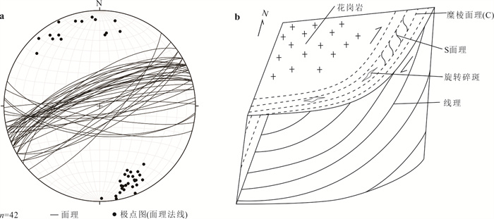
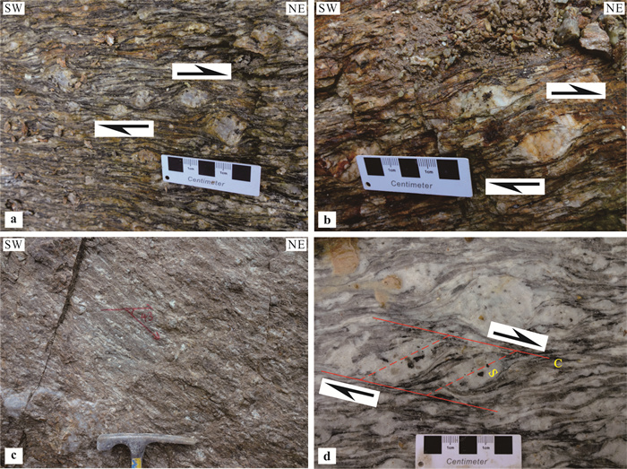
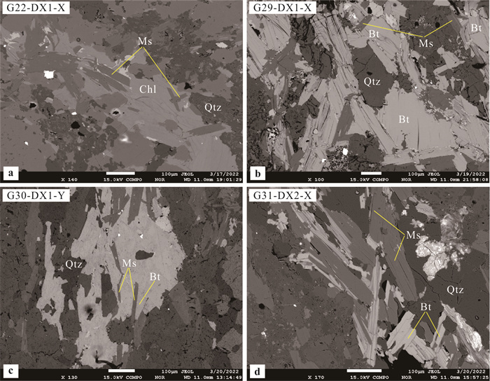
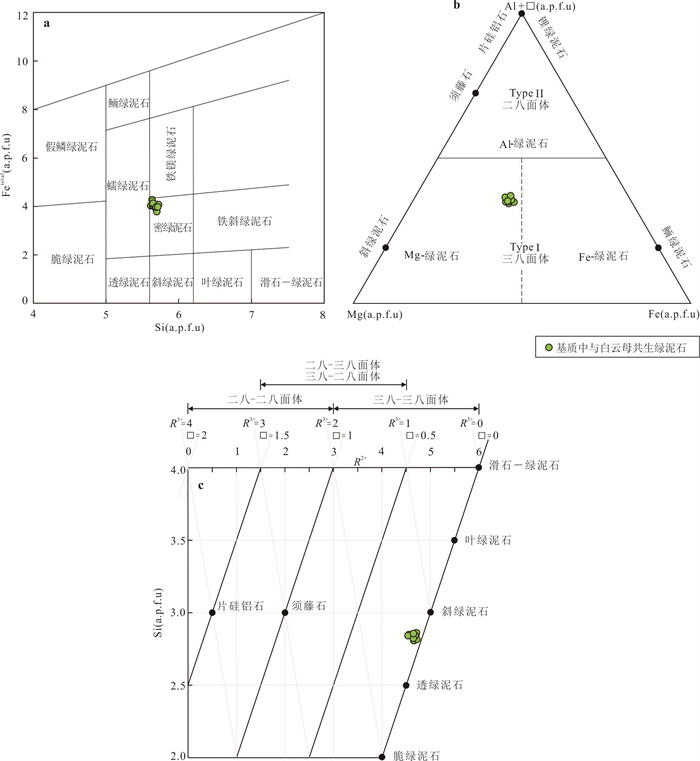
The measurement of metamorphic and deformation temperature of mylonites is of great significance for the interpretation of deformation evolution process and thermochronological isotope dating results. In this paper it only discusses the applicability of each geothermometers in the Nabu ductile shear zone. Using the plastic deformation characteristics, such as the mineral assemblage, dynamic recrystallization characteristics of minerals and EBSD (electron back-scattered diffraction) quartz c-axis fabrics in mylonites, the metamorphic deformation temperature range of the Nabu ductile shear zone is estimated to be 400 to 550 ℃. Based on the electron probe microanalysis (EMPA), the chlorite compositional geothermometer, muscovite-chlorite geothermometer, Ti-in-muscovite and Ti-in-biotite geothermometers were applied to calculate the metamorphic deformation temperature of the granitic mylonite samples in the Nabu ductile shear zone. The corresponding temperatures are 305 to 325 ℃, 390 to 500 ℃, 395 to 492 ℃ and 473 to 565 ℃, 431 to 574 ℃. Through comparative analysis, it is found that the results obtained by using chlorite compositional geothermometer are obviously lower than the temperature range estimated by using plastic deformation characteristics and the results calculated by other geothermometers. Combined with the results of previous studies, the chlorite compositional geothermometer is only suitable for the temperature calculation of low temperature metamorphic deformation. The results obtained by the other three geothermometers are all within the error range of the temperature estimated by using the plastic deformation characteristics, indicating that they are suitable for the calculation of metamorphic deformation temperature of the Nabu ductile shear zone. Among them, the muscovite-chlorite geothermometer is suitable for low temperature mylonite, and Ti-in-muscovite and Ti-in-biotite geothermometers are suitable for relatively high temperature mylonite.
The measurement of metamorphic and deformation temperature of mylonites is of great significance for the interpretation of deformation evolution process and thermochronological isotope dating results. In this paper it only discusses the applicability of each geothermometers in the Nabu ductile shear zone. Using the plastic deformation characteristics, such as the mineral assemblage, dynamic recrystallization characteristics of minerals and EBSD (electron back-scattered diffraction) quartz c-axis fabrics in mylonites, the metamorphic deformation temperature range of the Nabu ductile shear zone is estimated to be 400 to 550 ℃. Based on the electron probe microanalysis (EMPA), the chlorite compositional geothermometer, muscovite-chlorite geothermometer, Ti-in-muscovite and Ti-in-biotite geothermometers were applied to calculate the metamorphic deformation temperature of the granitic mylonite samples in the Nabu ductile shear zone. The corresponding temperatures are 305 to 325 ℃, 390 to 500 ℃, 395 to 492 ℃ and 473 to 565 ℃, 431 to 574 ℃. Through comparative analysis, it is found that the results obtained by using chlorite compositional geothermometer are obviously lower than the temperature range estimated by using plastic deformation characteristics and the results calculated by other geothermometers. Combined with the results of previous studies, the chlorite compositional geothermometer is only suitable for the temperature calculation of low temperature metamorphic deformation. The results obtained by the other three geothermometers are all within the error range of the temperature estimated by using the plastic deformation characteristics, indicating that they are suitable for the calculation of metamorphic deformation temperature of the Nabu ductile shear zone. Among them, the muscovite-chlorite geothermometer is suitable for low temperature mylonite, and Ti-in-muscovite and Ti-in-biotite geothermometers are suitable for relatively high temperature mylonite.


2024, 49(6): 1966-1982.
doi: 10.3799/dqkx.2022.057
Abstract:
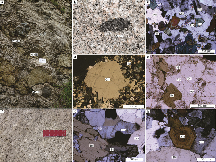
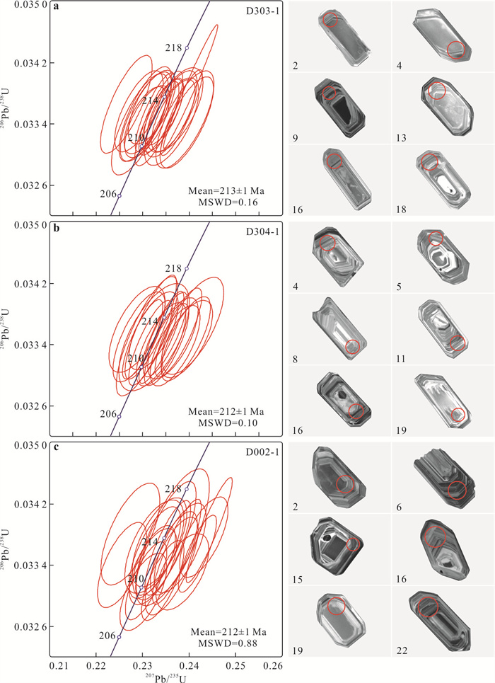
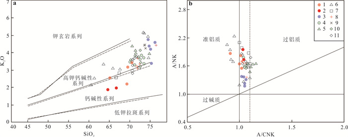
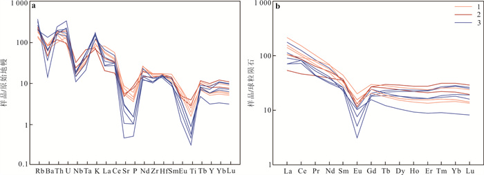
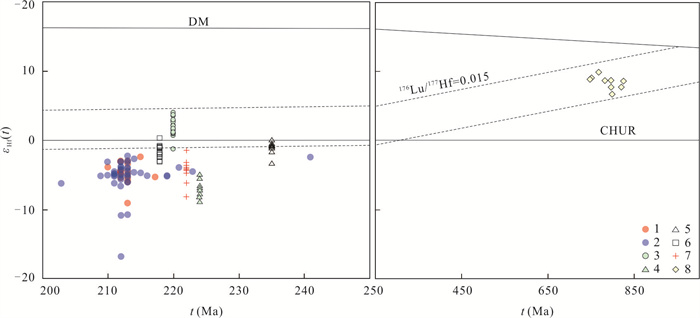
The genesis and tectonic setting of granitoids in the northern part of Daocheng batholith in West Sichuan are still debated. In this paper, a compilation of petrology, zircon U-Pb chronology, geochemistry and Hf isotopes was conducted on the granitoid to solve this uncertainty. LA-ICP-MS zircon U-Pb dating result shows that granitoids in the northern part of the batholith were formed at 213-212 Ma, slightly later than those in the southern part. Granitoids researched are mainly composed of granodiorite and monzogranite, the former of which contains many MME (mafic microgranular enclaves). Accessory minerals contain apatite, epidote, zircon and opaque minerals. Enrichment in sodium, and large ion lithophile elements, metaluminous to weak peraluminous are typical geochemical characteristics of the representative granitic samples. Their εHf(t) values are very scattered, ranging from -16.6 to 2.4 (average -5.0), reflecting average crustal residence age (t2DM) of 2.04-1.25 Ga (average 1.4) of the granitic source. Combined with regional geological evidence, the granitoids are I-type garanites derived from partial melting of basement metabasalt from the Mesoproterozoic Kangding complex, part of metagreywacks maybe involved in the acid member. Upwelling of asthenosphere and partial melting of the middle and lower crusts triggered by slab detachment under post-orogenic extension environment are responsible for the formation of granitoids.
The genesis and tectonic setting of granitoids in the northern part of Daocheng batholith in West Sichuan are still debated. In this paper, a compilation of petrology, zircon U-Pb chronology, geochemistry and Hf isotopes was conducted on the granitoid to solve this uncertainty. LA-ICP-MS zircon U-Pb dating result shows that granitoids in the northern part of the batholith were formed at 213-212 Ma, slightly later than those in the southern part. Granitoids researched are mainly composed of granodiorite and monzogranite, the former of which contains many MME (mafic microgranular enclaves). Accessory minerals contain apatite, epidote, zircon and opaque minerals. Enrichment in sodium, and large ion lithophile elements, metaluminous to weak peraluminous are typical geochemical characteristics of the representative granitic samples. Their εHf(t) values are very scattered, ranging from -16.6 to 2.4 (average -5.0), reflecting average crustal residence age (t2DM) of 2.04-1.25 Ga (average 1.4) of the granitic source. Combined with regional geological evidence, the granitoids are I-type garanites derived from partial melting of basement metabasalt from the Mesoproterozoic Kangding complex, part of metagreywacks maybe involved in the acid member. Upwelling of asthenosphere and partial melting of the middle and lower crusts triggered by slab detachment under post-orogenic extension environment are responsible for the formation of granitoids.

2024, 49(6): 1983-2000.
doi: 10.3799/dqkx.2022.105
Abstract:
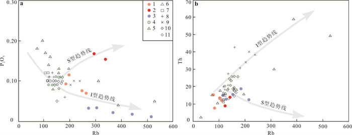
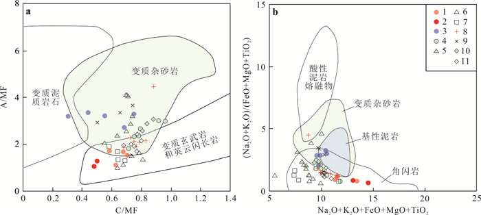
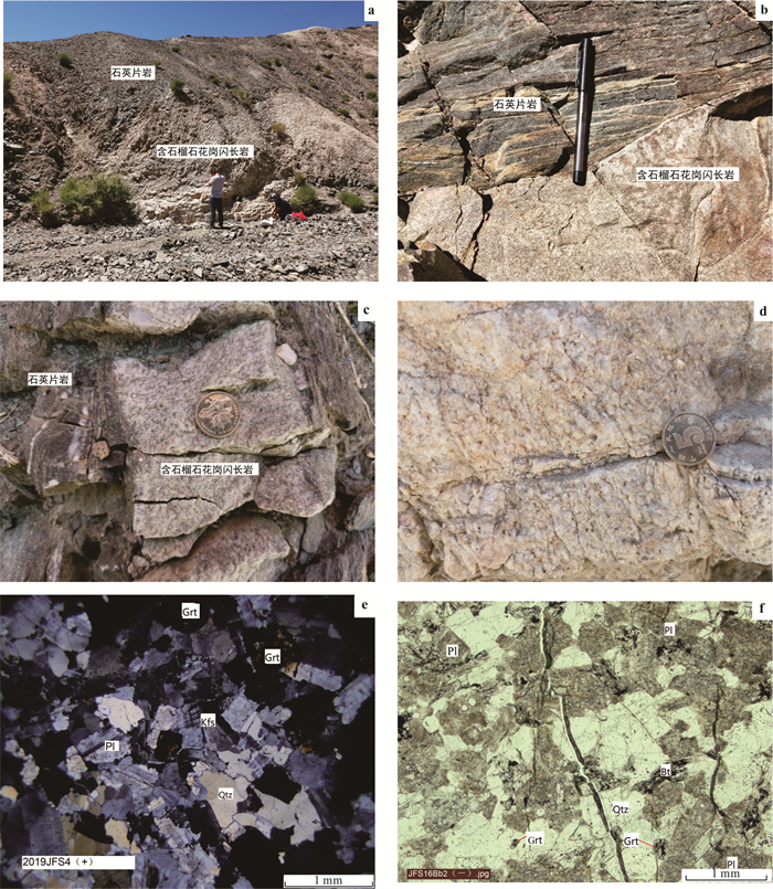
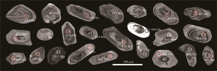
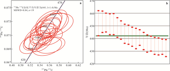
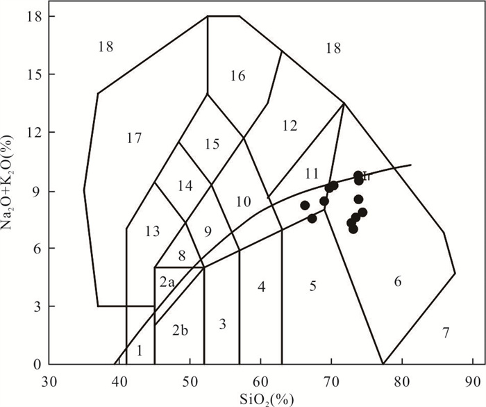
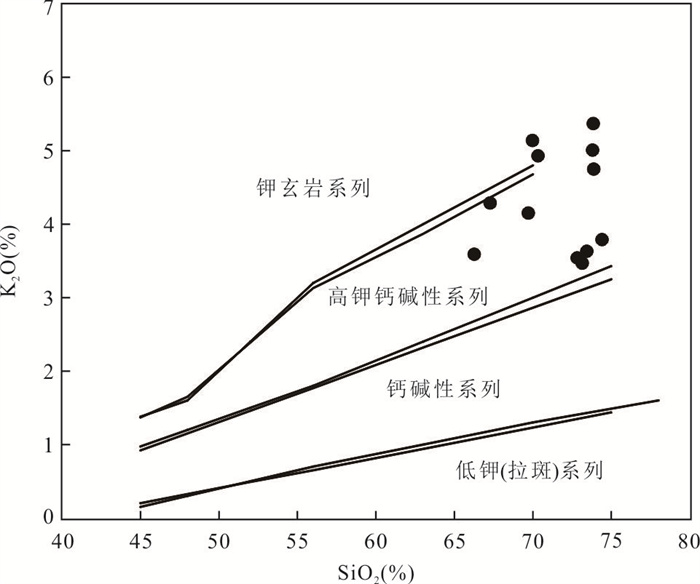
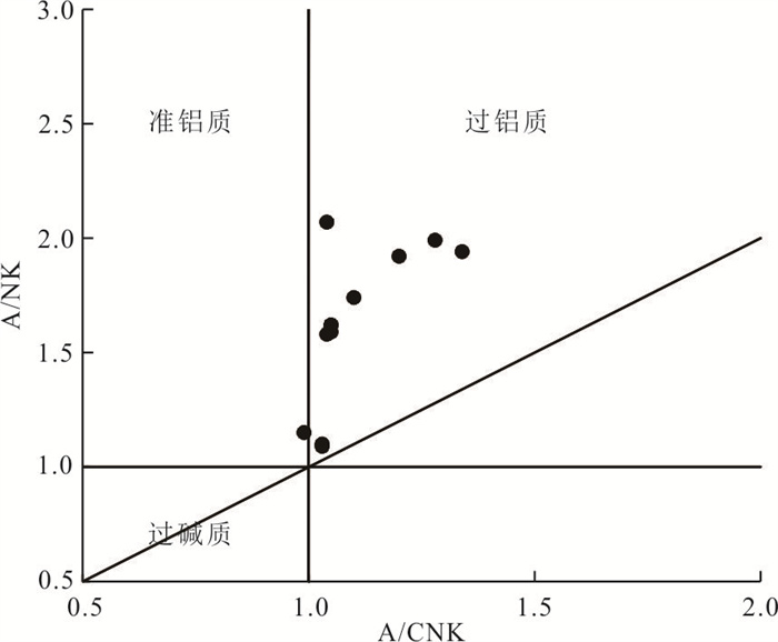
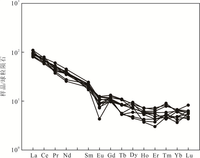
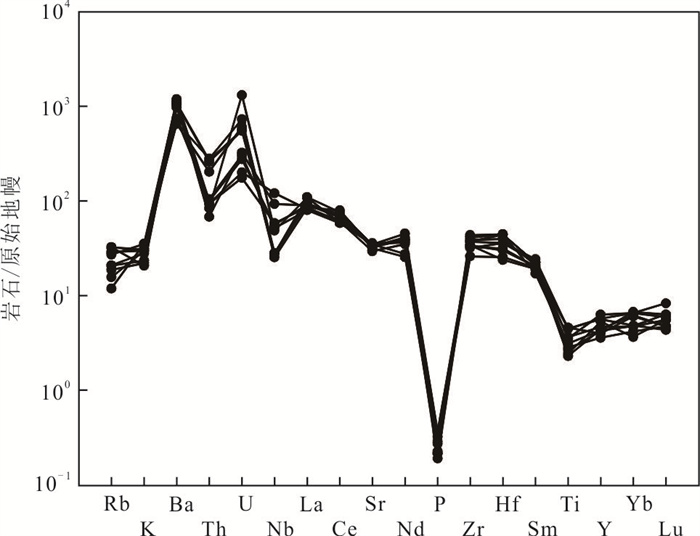
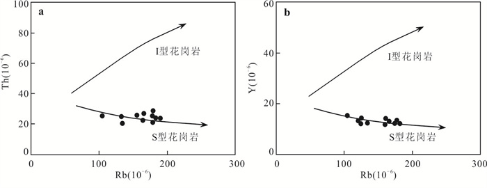
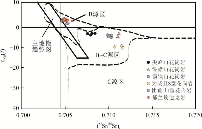
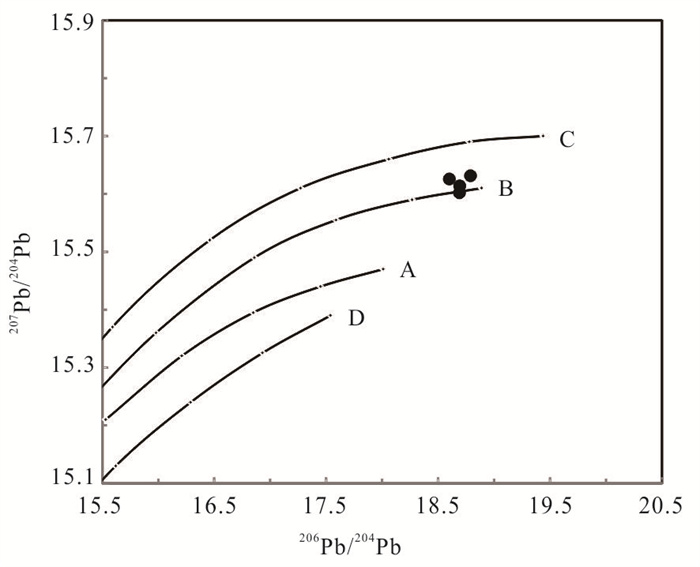
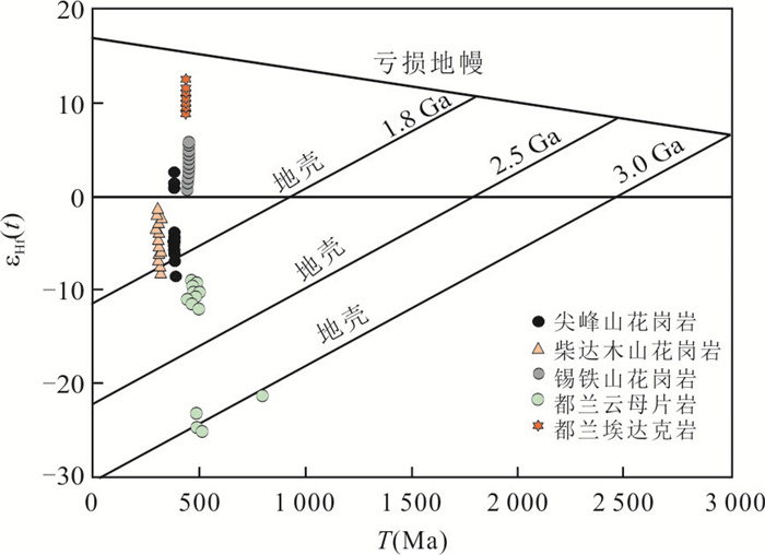
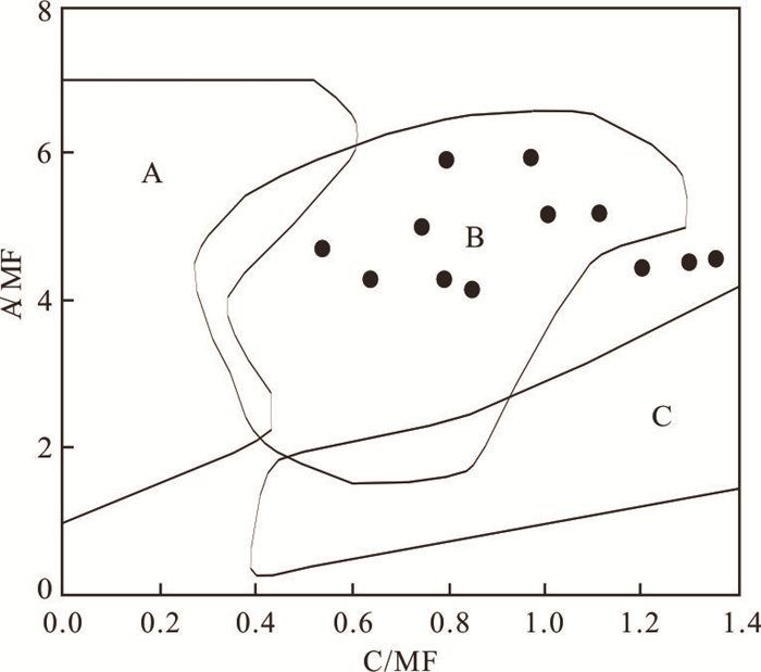
Garnet bearing granodiorite in the Jianfengshan area on the northern margin of Qaidam basin is vein distributed in Dakendaban rock group. The rocks are mainly composed of quartz (30%-35%), plagioclase (45%-50%), potassium feldspar (15%-20%), biotite (5%) and a small amount of muscovite (< 5%), garnet (< 5%).Zircon U-Pb dating shows that the formation age of garnet bearing granodiorite is (441.1 ± 1.4) Ma, belonging to Early Silurian.The rocks have high SiO2 (66.27%-74.42%), Na2O (3.47%-6.75%), Al2O3 (14.71%-20.43%), low MgO (0.07%-0.56%), Mg# (19.8-43.6) contents and strong peraluminite (A/CNK ranges from 0.99~1.34).The minerals are enriched in U, K, Ba and depleted in Nb, Ta, Sr, P, Eu, Ti and other elements. The REE distribution curves show a right-leaning pattern, showing a weak negative Eu anomaly (δEu= 0.31-0.81). The rocks have high ISr values (0.707 123-0.708 081) and negative εNd(t) values (-1.91 to -2.37), and the two-stage model age TDM2 is 1 660-1 756 Ma. After correction, (206Pb/204Pb)i value is 18.354 7-18.582 2, (207Pb/204Pb)i value is 15.365 4-15.641 2, (208Pb/204Pb)i value is 38.254 7-38.654 1. Zircon Hf εHf(t) ratios range from 2.5 to -9.1, and the corresponding Hf isotopic crust model ages TDM2 range in 1 263-2 012 Ma. The study of rock geochemistry and isotopes shows that the garnet bearing granodiorite in the Jianfengshan is an S-type granite, which was formed in the collision orogenic stage between Qaidam block and Qilian block. It is the early subducted continental and oceanic crust that experienced ultra-high pressure metamorphism (eclogite facies conditions) and the rise of partially molten fluid, resulting in the partial melting of the continental crust.
Garnet bearing granodiorite in the Jianfengshan area on the northern margin of Qaidam basin is vein distributed in Dakendaban rock group. The rocks are mainly composed of quartz (30%-35%), plagioclase (45%-50%), potassium feldspar (15%-20%), biotite (5%) and a small amount of muscovite (< 5%), garnet (< 5%).Zircon U-Pb dating shows that the formation age of garnet bearing granodiorite is (441.1 ± 1.4) Ma, belonging to Early Silurian.The rocks have high SiO2 (66.27%-74.42%), Na2O (3.47%-6.75%), Al2O3 (14.71%-20.43%), low MgO (0.07%-0.56%), Mg# (19.8-43.6) contents and strong peraluminite (A/CNK ranges from 0.99~1.34).The minerals are enriched in U, K, Ba and depleted in Nb, Ta, Sr, P, Eu, Ti and other elements. The REE distribution curves show a right-leaning pattern, showing a weak negative Eu anomaly (δEu= 0.31-0.81). The rocks have high ISr values (0.707 123-0.708 081) and negative εNd(t) values (-1.91 to -2.37), and the two-stage model age TDM2 is 1 660-1 756 Ma. After correction, (206Pb/204Pb)i value is 18.354 7-18.582 2, (207Pb/204Pb)i value is 15.365 4-15.641 2, (208Pb/204Pb)i value is 38.254 7-38.654 1. Zircon Hf εHf(t) ratios range from 2.5 to -9.1, and the corresponding Hf isotopic crust model ages TDM2 range in 1 263-2 012 Ma. The study of rock geochemistry and isotopes shows that the garnet bearing granodiorite in the Jianfengshan is an S-type granite, which was formed in the collision orogenic stage between Qaidam block and Qilian block. It is the early subducted continental and oceanic crust that experienced ultra-high pressure metamorphism (eclogite facies conditions) and the rise of partially molten fluid, resulting in the partial melting of the continental crust.

2024, 49(6): 2001-2023.
doi: 10.3799/dqkx.2024.007
Abstract:
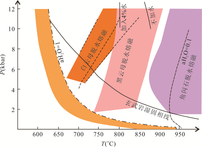
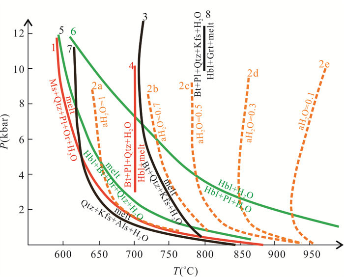
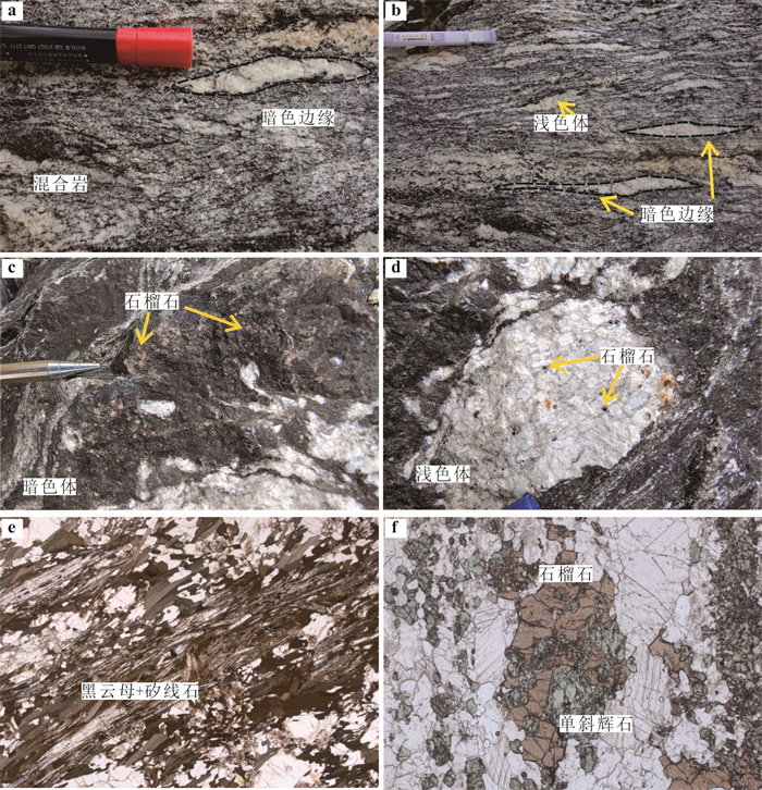
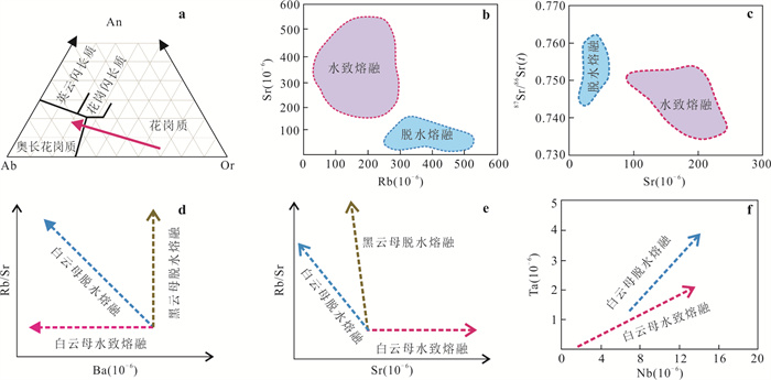
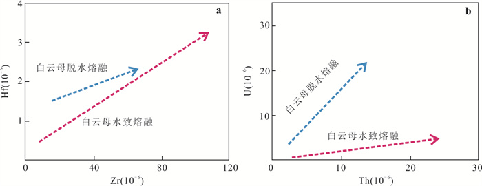
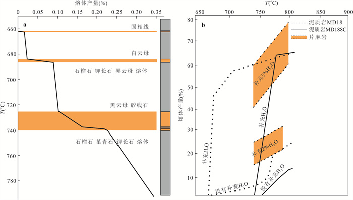
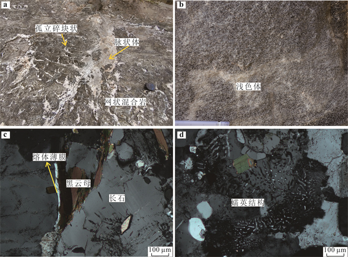
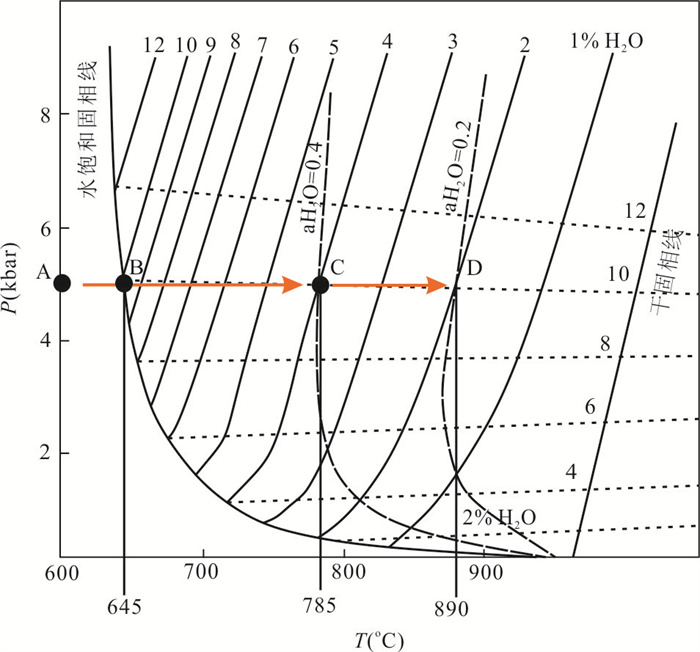
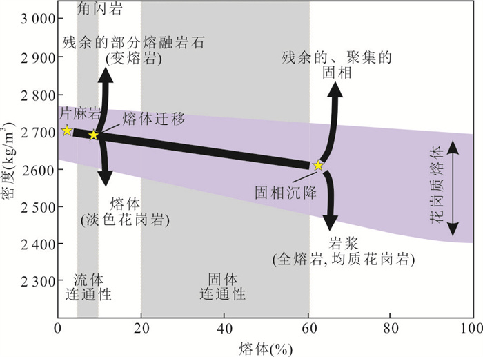
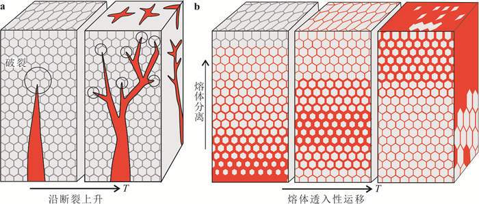
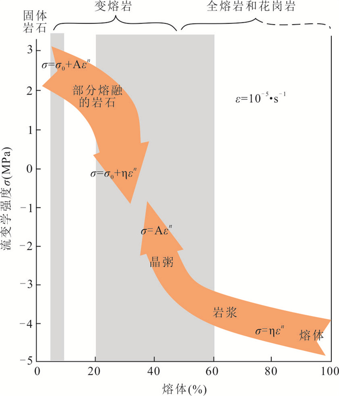
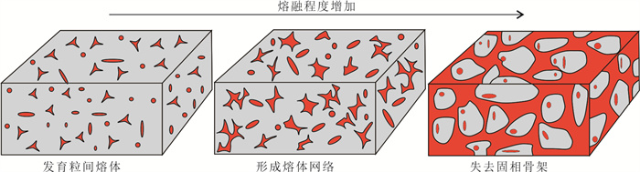
Anatexis is significant for the evolution and rheological properties of the continental crust, linking metamorphism, tectonic deformation, and magmatic activities in deep crust. According to the presence or absence of free water, anatexis can be divided into water-fluxed melting and dehydration melting. Dehydration melting involves the breakdown of hydrous phases, such as muscovite, biotite or amphibole. Generally, dehydration melting reactions begin at ~650 ℃ and produce melt, peritectic garnet and K-feldspar. Melt resulting from dehydration melting is water unsaturated, characterized by high Rb, high Rb/Sr ratio, high 87Sr/86Sr ratio, and low Sr, Ba, Ca. Melt productivity of dehydration melting reaction is controlled by P-T condition and water content in rock, and it is only possible to produce a large amount of melt at granulite facies. Water-fluxed melting reactions involve the presence of free water. Its most significant feature is that the temperature required is relatively low, and can produce voluminous melting at amphibolite facies. The resulting melt is water-saturated or water unsaturated that can extract from the source. Melt derived from water-fluxed melting reactions has high Sr, Ba, Ca, low Rb/Sr ratio and low Rb. Anatexis has a profound impact on the thermodynamic and rheological properties of the rocks. At the same time, the movement of melt out of the lower continental crust promotes the chemical differentiation of the crust and forms a wide range of leucogranite, playing a crucial role in the origin, reworking, and stability of the continental crust.
Anatexis is significant for the evolution and rheological properties of the continental crust, linking metamorphism, tectonic deformation, and magmatic activities in deep crust. According to the presence or absence of free water, anatexis can be divided into water-fluxed melting and dehydration melting. Dehydration melting involves the breakdown of hydrous phases, such as muscovite, biotite or amphibole. Generally, dehydration melting reactions begin at ~650 ℃ and produce melt, peritectic garnet and K-feldspar. Melt resulting from dehydration melting is water unsaturated, characterized by high Rb, high Rb/Sr ratio, high 87Sr/86Sr ratio, and low Sr, Ba, Ca. Melt productivity of dehydration melting reaction is controlled by P-T condition and water content in rock, and it is only possible to produce a large amount of melt at granulite facies. Water-fluxed melting reactions involve the presence of free water. Its most significant feature is that the temperature required is relatively low, and can produce voluminous melting at amphibolite facies. The resulting melt is water-saturated or water unsaturated that can extract from the source. Melt derived from water-fluxed melting reactions has high Sr, Ba, Ca, low Rb/Sr ratio and low Rb. Anatexis has a profound impact on the thermodynamic and rheological properties of the rocks. At the same time, the movement of melt out of the lower continental crust promotes the chemical differentiation of the crust and forms a wide range of leucogranite, playing a crucial role in the origin, reworking, and stability of the continental crust.
2024, 49(6): 2024-2043.
doi: 10.3799/dqkx.2023.181
Abstract:
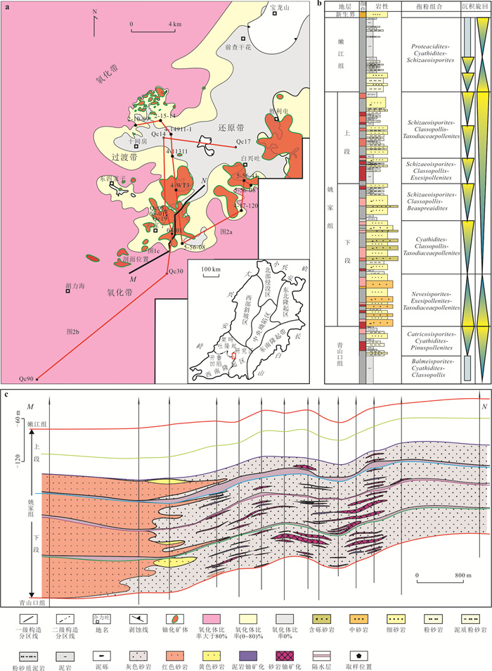
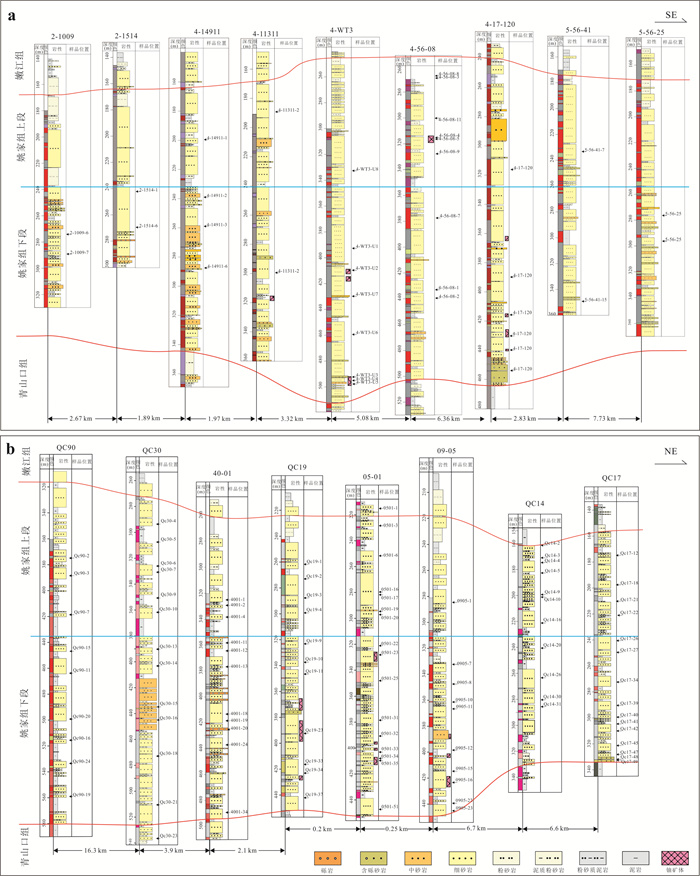
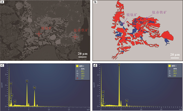
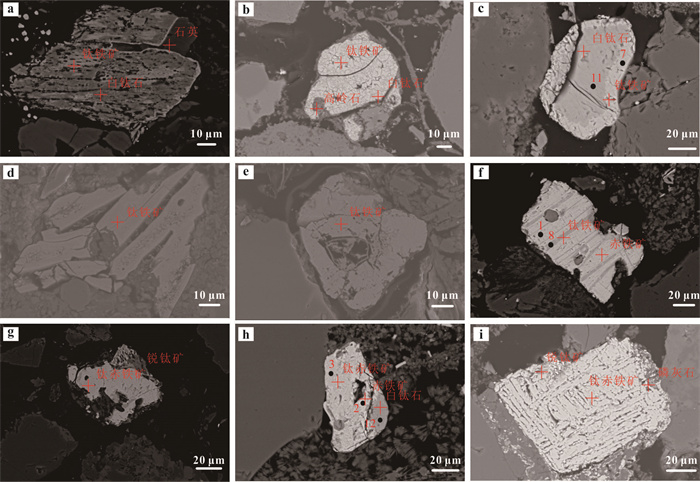
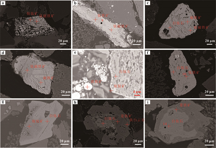
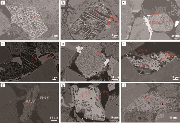
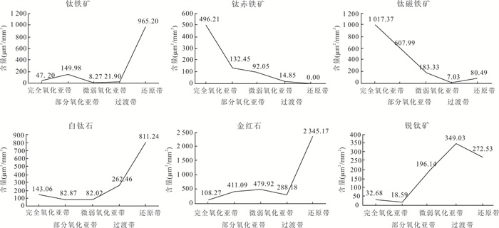
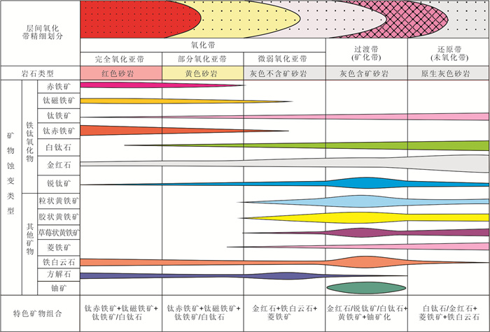
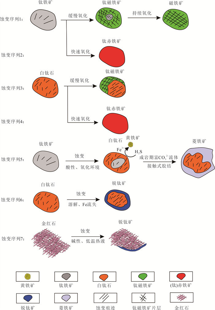
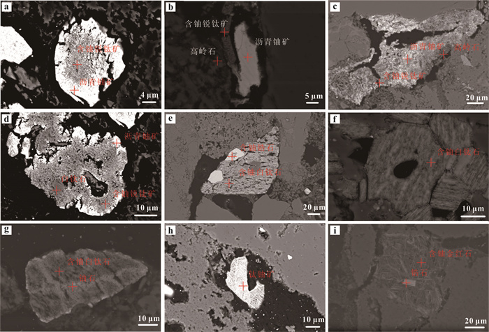
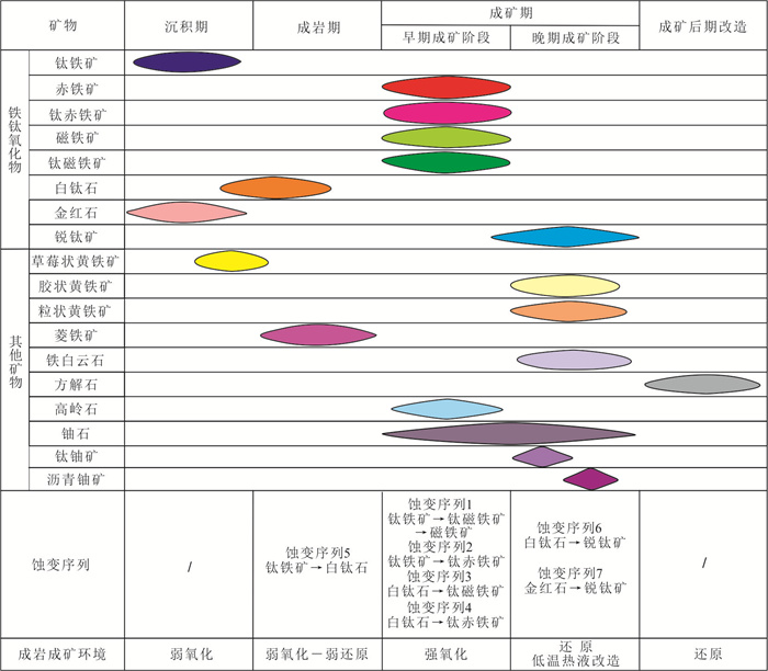
Fe-Ti oxides are extremely sensitive to changes in the redox environment and are extremely important indicator minerals for studying the mineralization of sandstone-type uranium deposits. However, there are few quantitative data constraints on morphology, contents and compositions of Fe-Ti oxides in the interlayer oxidation zone of sandstone-type uranium deposits. Therefore, in this study it focuses on illustrating Fe-Ti oxides in the interlayer oxidation zone of Qianjiadian uranium deposit in Songliao basin. Six types of Fe-Ti oxides including ilmenite, titanohematite, titanomagnetite, leucoxene, rutile and anatase have been identified by polarizing microscope, SEM and electron probe microanalyzer. The titanohematite and titanomagnetite mainly occur in the strong oxidised subzone and weak oxidised subzone; the leucoxene, anatase and titanium magnetite are mainly distributed in the faint oxidised subzone; the leucoxene and anatase are primarily formed in the transition zone, and the rutile, ilmenite and leucoxene are frequently found in the reduction zone. Seven alteration sequences are identified according to the interspersed wrapping relationship between Fe-Ti oxides in each zone. Four alteration sequences composed of ilmenite →titanomagnetite→magnetite, ilmenite→titanohematite, leucoxene→ titanomagnetite → magnetite and leucoxene → titanohematite are mainly found in the strong oxidised subzone, weak oxidised subzone and faint oxidised subzone, and these sequences record a large-scale interlayer oxidation event. Two alteration sequences including leucoxene → anatase and rutile → anatase primarily occur in the transition zone, these sequences reveal that the deposit was transformed by low-temperature hydrothermal fluids. The last alteration sequence is ilmenite→anatase which mainly occur in the reduction zone, and this sequence reflects a weakly acidic-weakly alkaline environment during diagenesis. The research provides a foundation for the studying Fe-Ti oxides as indicator minerals to study fine zoning of interlayer oxidation zones and mineralization process of sandstone-type uranium deposits.
Fe-Ti oxides are extremely sensitive to changes in the redox environment and are extremely important indicator minerals for studying the mineralization of sandstone-type uranium deposits. However, there are few quantitative data constraints on morphology, contents and compositions of Fe-Ti oxides in the interlayer oxidation zone of sandstone-type uranium deposits. Therefore, in this study it focuses on illustrating Fe-Ti oxides in the interlayer oxidation zone of Qianjiadian uranium deposit in Songliao basin. Six types of Fe-Ti oxides including ilmenite, titanohematite, titanomagnetite, leucoxene, rutile and anatase have been identified by polarizing microscope, SEM and electron probe microanalyzer. The titanohematite and titanomagnetite mainly occur in the strong oxidised subzone and weak oxidised subzone; the leucoxene, anatase and titanium magnetite are mainly distributed in the faint oxidised subzone; the leucoxene and anatase are primarily formed in the transition zone, and the rutile, ilmenite and leucoxene are frequently found in the reduction zone. Seven alteration sequences are identified according to the interspersed wrapping relationship between Fe-Ti oxides in each zone. Four alteration sequences composed of ilmenite →titanomagnetite→magnetite, ilmenite→titanohematite, leucoxene→ titanomagnetite → magnetite and leucoxene → titanohematite are mainly found in the strong oxidised subzone, weak oxidised subzone and faint oxidised subzone, and these sequences record a large-scale interlayer oxidation event. Two alteration sequences including leucoxene → anatase and rutile → anatase primarily occur in the transition zone, these sequences reveal that the deposit was transformed by low-temperature hydrothermal fluids. The last alteration sequence is ilmenite→anatase which mainly occur in the reduction zone, and this sequence reflects a weakly acidic-weakly alkaline environment during diagenesis. The research provides a foundation for the studying Fe-Ti oxides as indicator minerals to study fine zoning of interlayer oxidation zones and mineralization process of sandstone-type uranium deposits.
2024, 49(6): 2044-2057.
doi: 10.3799/dqkx.2024.001
Abstract:
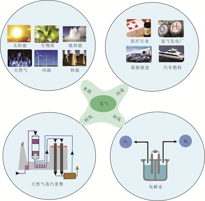
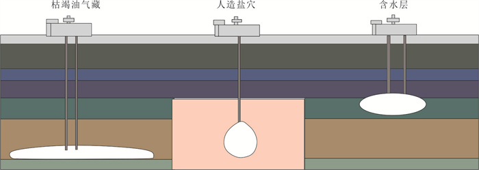
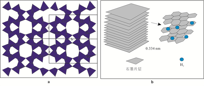
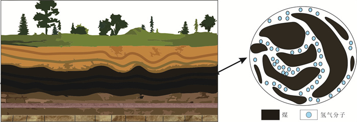
As the importance of hydrogen continues to grow, large-scale hydrogen storage is receiving increasing focus. In this paper it extensively examines the classification, advantages, and drawbacks of underground hydrogen storage facilities through comprehensive literature research, providing a theoretical foundation for the implementation of such storage systems. Furthermore, it elucidates the interactions between hydrogen and minerals, and highlights the hydrogen adsorption characteristics of clay minerals and coal seams, offering novel insights into addressing challenges related to large-scale hydrogen storage and low-cost adsorption-based storage. The study findings reveal that (1) hydrogen storage facilities are primarily categorized into salt cavern storage, depleted oil and gas reservoir storage, and aquifer storage, with salt cavern storage currently being the most favorable option; (2) variations in temperature, pressure, concentration of fatty acids, and organic acid carbon number affect the hydrogen wettability of minerals, thus impacting caprock sealing capacity; and (3) certain clay minerals, coal seams, and other materials can adsorb hydrogen, presenting potential avenues for new underground hydrogen storage materials. Based on the above research and analysis, the main problems existing in underground hydrogen storage are pointed out, and the future development prospect of underground hydrogen storage is prospected, in order to provide reference for the site selection and implementation of underground hydrogen storage. The feasibility of underground porous material as a new large-scale hydrogen storage material is briefly summarized, in order to contribute to the search for diversified and suitable hydrogen storage materials.
As the importance of hydrogen continues to grow, large-scale hydrogen storage is receiving increasing focus. In this paper it extensively examines the classification, advantages, and drawbacks of underground hydrogen storage facilities through comprehensive literature research, providing a theoretical foundation for the implementation of such storage systems. Furthermore, it elucidates the interactions between hydrogen and minerals, and highlights the hydrogen adsorption characteristics of clay minerals and coal seams, offering novel insights into addressing challenges related to large-scale hydrogen storage and low-cost adsorption-based storage. The study findings reveal that (1) hydrogen storage facilities are primarily categorized into salt cavern storage, depleted oil and gas reservoir storage, and aquifer storage, with salt cavern storage currently being the most favorable option; (2) variations in temperature, pressure, concentration of fatty acids, and organic acid carbon number affect the hydrogen wettability of minerals, thus impacting caprock sealing capacity; and (3) certain clay minerals, coal seams, and other materials can adsorb hydrogen, presenting potential avenues for new underground hydrogen storage materials. Based on the above research and analysis, the main problems existing in underground hydrogen storage are pointed out, and the future development prospect of underground hydrogen storage is prospected, in order to provide reference for the site selection and implementation of underground hydrogen storage. The feasibility of underground porous material as a new large-scale hydrogen storage material is briefly summarized, in order to contribute to the search for diversified and suitable hydrogen storage materials.

2024, 49(6): 2058-2070.
doi: 10.3799/dqkx.2023.111
Abstract:
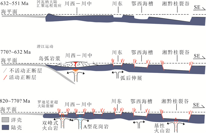
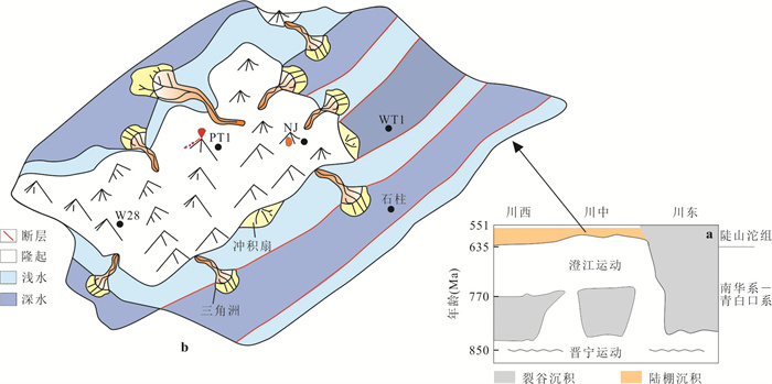
According to geochemical information analysis of Neoproterozoic igneous rocks in the periphery and interior of Sichuan basin, there are two completely different understandings of extension and extrusion. The geophysical data show that the deep rifting of the basin is widespread, and there are obvious uplift and denudation in the central and western parts of the basin until the deposition period of Doushantuo Formation. The tectonic transformation process between the two is unclear. To solve these problems, in this paper it explores the Neoproterozoic tectonic evolution and favorable oil and gas areas of the Sichuan basin through the interpretation of seismic reflection profiles and the analysis of petrogeochemistry, drilling data and outcrop sedimentary sequences. The results in this study show that the oceanic subduction was the cause of the rift-uplift denudation transformation in the western and central Sichuan during the period from the breakup of the Rodinia supercontinent to the convergence of the Gondwana supercontinent, while the eastern Sichuan area was always in tectonic subsidence in the middle and late Neoproterozoic (820-551 Ma).There may only be organic rocks of Wuye Formation at the same time in the Neoproterozoic of western Sichuan and central Sichuan, and clastic reservoirs are developed between the uplift area of central Sichuan and the subsidence area of eastern Sichuan.
According to geochemical information analysis of Neoproterozoic igneous rocks in the periphery and interior of Sichuan basin, there are two completely different understandings of extension and extrusion. The geophysical data show that the deep rifting of the basin is widespread, and there are obvious uplift and denudation in the central and western parts of the basin until the deposition period of Doushantuo Formation. The tectonic transformation process between the two is unclear. To solve these problems, in this paper it explores the Neoproterozoic tectonic evolution and favorable oil and gas areas of the Sichuan basin through the interpretation of seismic reflection profiles and the analysis of petrogeochemistry, drilling data and outcrop sedimentary sequences. The results in this study show that the oceanic subduction was the cause of the rift-uplift denudation transformation in the western and central Sichuan during the period from the breakup of the Rodinia supercontinent to the convergence of the Gondwana supercontinent, while the eastern Sichuan area was always in tectonic subsidence in the middle and late Neoproterozoic (820-551 Ma).There may only be organic rocks of Wuye Formation at the same time in the Neoproterozoic of western Sichuan and central Sichuan, and clastic reservoirs are developed between the uplift area of central Sichuan and the subsidence area of eastern Sichuan.
2024, 49(6): 2071-2084.
doi: 10.3799/dqkx.2022.480
Abstract:
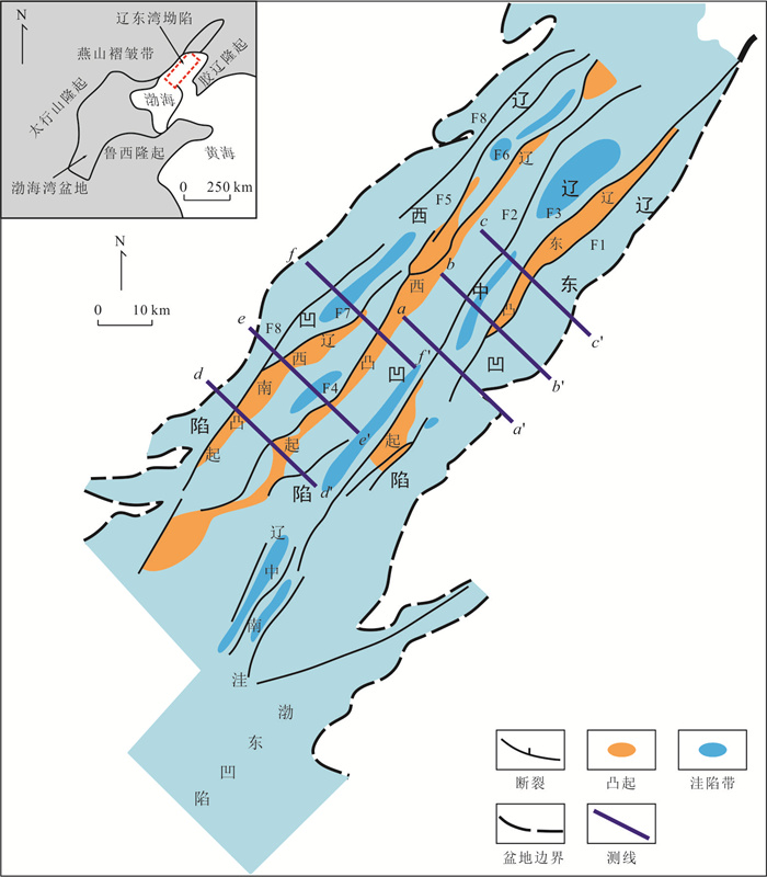
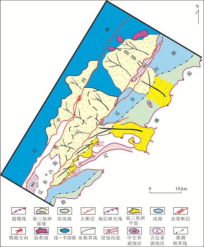
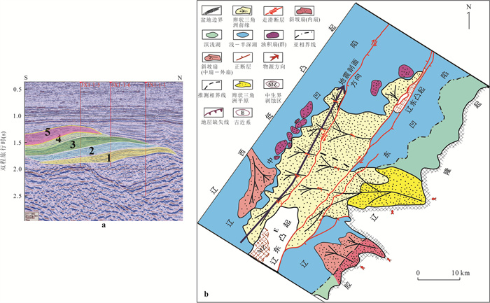
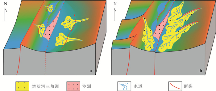
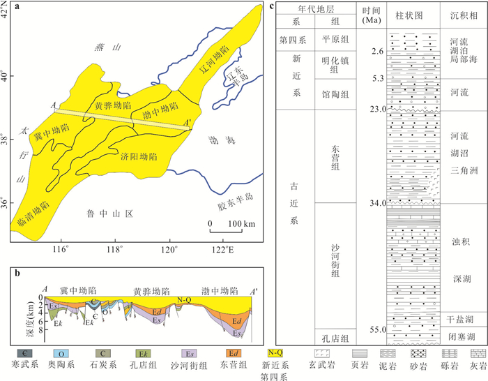
The Tan-Lu Fault Zone has undergone a complex evolutionary process during Cenozoic, and the controversy is mainly focused on the period of the beginning of dextral strike-slip. In this paper, based on various geological and geophysical data and previous research results, taking the Liaodong Bay Section in Bohai Sea as an example, the time limit of dextral strike-slip activity of the Tan-lu fault zone is systematically discussed from both tectonic and sedimentological aspects based on various evidence. The results show that the dextral strike-slip activity of the Liaodong Bay Section of the Tan-Lu fault zone cut and modified the early (Kongdian-the third member of Shahejie formation depositional period) extensional faults, the R-shear fracture was formed in the Late Oligocence Dongying Formation depositional period, and the strike-slip derived structures were mainly developed in the Dongying Formation depositional period until now. The dextral strike-slip activity in the Liaodong Bay Section of the Tan-Lu fault zone staggered the sedimentary bodies formed in Early and Middle Paleogene(Kongdian-Shahejie formation depositional period), and the syndepositional dextral strike-slip activity led to the development and spreading of fish-jumping sand bodies, axial or oblique sand bodies, and the local depression formation controlled by the pressure release effect of bending strike-slip fault. The dextral strike-slip in Cenozoic of the Liaodong Bay Section of the Tan-Lu fault zone was mainly during the depositional period of the Dongying Formation in the Late Oligocene of the Paleogene, and then gradually weakened and continued until now.
The Tan-Lu Fault Zone has undergone a complex evolutionary process during Cenozoic, and the controversy is mainly focused on the period of the beginning of dextral strike-slip. In this paper, based on various geological and geophysical data and previous research results, taking the Liaodong Bay Section in Bohai Sea as an example, the time limit of dextral strike-slip activity of the Tan-lu fault zone is systematically discussed from both tectonic and sedimentological aspects based on various evidence. The results show that the dextral strike-slip activity of the Liaodong Bay Section of the Tan-Lu fault zone cut and modified the early (Kongdian-the third member of Shahejie formation depositional period) extensional faults, the R-shear fracture was formed in the Late Oligocence Dongying Formation depositional period, and the strike-slip derived structures were mainly developed in the Dongying Formation depositional period until now. The dextral strike-slip activity in the Liaodong Bay Section of the Tan-Lu fault zone staggered the sedimentary bodies formed in Early and Middle Paleogene(Kongdian-Shahejie formation depositional period), and the syndepositional dextral strike-slip activity led to the development and spreading of fish-jumping sand bodies, axial or oblique sand bodies, and the local depression formation controlled by the pressure release effect of bending strike-slip fault. The dextral strike-slip in Cenozoic of the Liaodong Bay Section of the Tan-Lu fault zone was mainly during the depositional period of the Dongying Formation in the Late Oligocene of the Paleogene, and then gradually weakened and continued until now.
2024, 49(6): 2085-2102.
doi: 10.3799/dqkx.2022.187
Abstract:
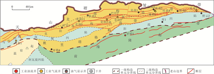
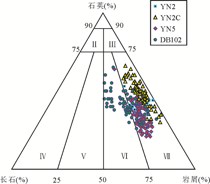
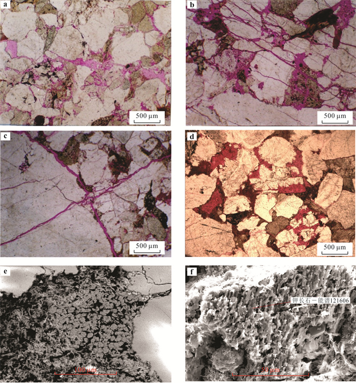
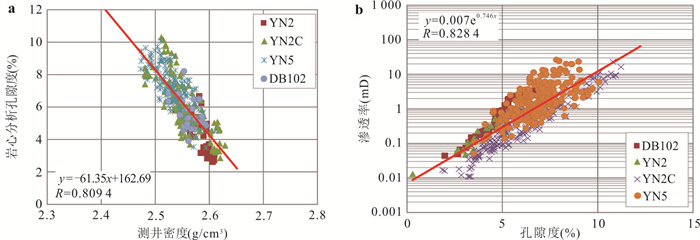
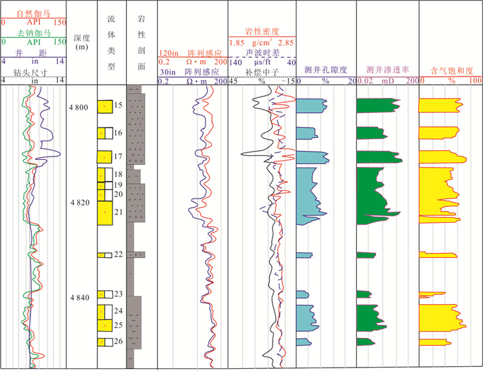
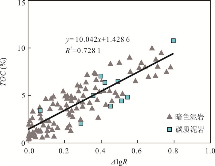
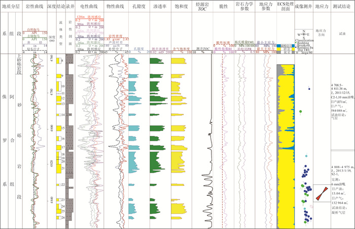
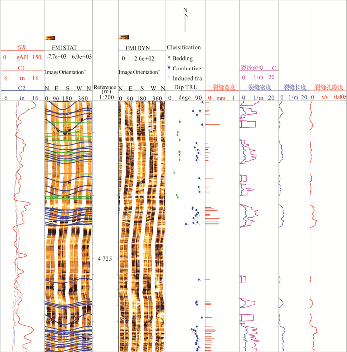
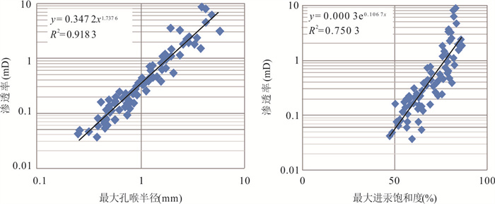
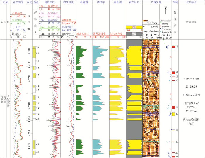
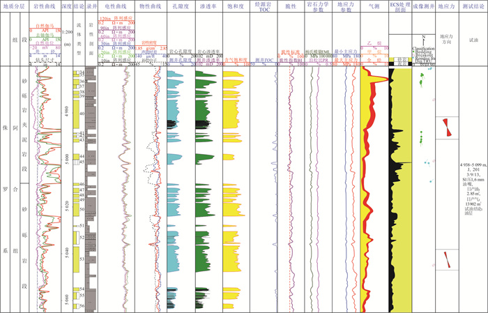
In order to unravel the tight gas reservoir characteristics and establish the well log evaluation methods of Jurassic tight gas reservoirs in Kuqa depression, core observation, rock physics experiment, conventional logging and image log data were used to unravel the "seven relations" of lithology, physical property, electrical property, oil-gas bearing property, brittleness, source rock properties and in-situ stress of Jurassic Ahe Formation tight sandstone gas reservoir in monocline zone of northern Kuqa depression. The logging interpretation model of porosity, permeability and gas saturation was established, and well logging calculation model of TOC (total organic carbon), brittleness index as well as triaxial in-situ stress profile were established respectively. Then the logging methods of source rock property, reservoir quality and engineering quality are established based on the research of "seven relations". The results show that the lithology of Ahe Formation mainly includes conglomerate, medium-coarse sandstone and mudstone. The reservoir spaces are mainly intergranular dissolution pore, intragranular dissolution pore, micro-fractures and micro-pores. The typical gas-bearing interval is characterized by low gamma ray (< 60 API), high resistance (> 10 Ω·m) and high acoustic time difference (> 70 μs/ft). The source rock quality was characterized by TOC content calculated by logging, and four reservoir quality types were classified according to physical property test, mercury injection test and the degree of fracture development. The engineering quality was identified and classified mainly by brittleness index and in-situ stress. Finally, the logging evaluation results of "three qualities" were applied to the evaluation and prediction of single well productivity, which is in good agreement with the actual well test, and the results were testified in the eight intervals of seven wells including DB 101 and other wells.
In order to unravel the tight gas reservoir characteristics and establish the well log evaluation methods of Jurassic tight gas reservoirs in Kuqa depression, core observation, rock physics experiment, conventional logging and image log data were used to unravel the "seven relations" of lithology, physical property, electrical property, oil-gas bearing property, brittleness, source rock properties and in-situ stress of Jurassic Ahe Formation tight sandstone gas reservoir in monocline zone of northern Kuqa depression. The logging interpretation model of porosity, permeability and gas saturation was established, and well logging calculation model of TOC (total organic carbon), brittleness index as well as triaxial in-situ stress profile were established respectively. Then the logging methods of source rock property, reservoir quality and engineering quality are established based on the research of "seven relations". The results show that the lithology of Ahe Formation mainly includes conglomerate, medium-coarse sandstone and mudstone. The reservoir spaces are mainly intergranular dissolution pore, intragranular dissolution pore, micro-fractures and micro-pores. The typical gas-bearing interval is characterized by low gamma ray (< 60 API), high resistance (> 10 Ω·m) and high acoustic time difference (> 70 μs/ft). The source rock quality was characterized by TOC content calculated by logging, and four reservoir quality types were classified according to physical property test, mercury injection test and the degree of fracture development. The engineering quality was identified and classified mainly by brittleness index and in-situ stress. Finally, the logging evaluation results of "three qualities" were applied to the evaluation and prediction of single well productivity, which is in good agreement with the actual well test, and the results were testified in the eight intervals of seven wells including DB 101 and other wells.

2024, 49(6): 2103-2119.
doi: 10.3799/dqkx.2023.210
Abstract:
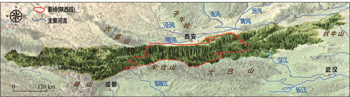
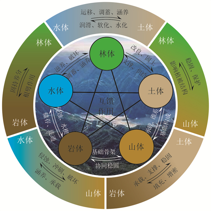
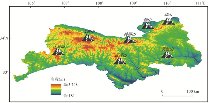
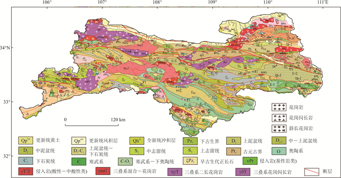
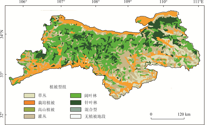
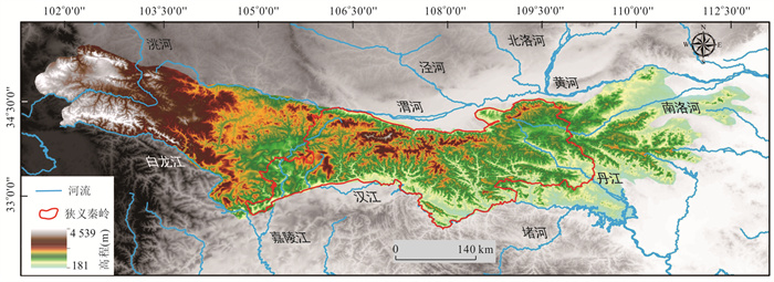
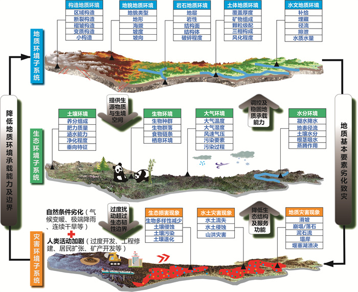
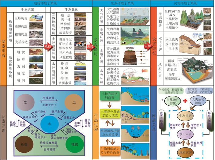
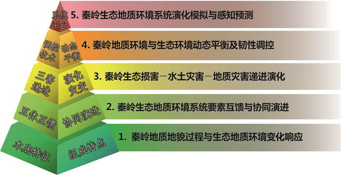
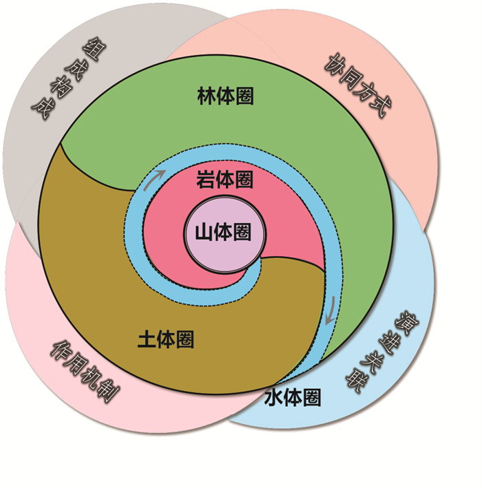
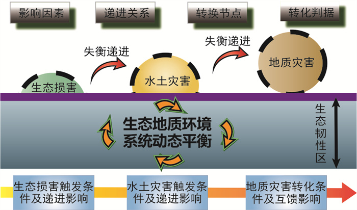
The construction of ecological civilization has become a major strategic task related to the well-being of the people and the future of the nation. As China's geographic boundary zone, climate zoning zone and ecological barrier zone, Qinling Mountain is also an important water conservation area of the Yellow River and Yangtze River. Its ecological barrier function is crucial to maintain the ecological security of the whole China and plays an important role in China's ecological geological pattern. However, under the influence of climate change and human activities, the Qinling Mountain is faced with a series of problems, such as changeable geological environment, fragile ecological environment, frequent geological disasters, and disharmony between human and land systems, which lead to the serious limitation of the central ecological barrier function. As the carrier of ecological system, Qinling ecological geological environment is the basic research work of Qinling ecological protection and sustainable development. In this paper it attempts to sort out the composition and background characteristics of the elements of the ecological geological environment system in the Qinling Mountain, grasp the mutual feeding and synergistic evolution relationship of the elements of the ecological geological environment system in the Qinling Mountain, define the progressive evolution process of ecological damage, soil and water disasters and geological disasters in the Qinling Mountain, and then build the research system of the ecological geological environment system in the Qinling Mountain. At the same time, it preliminarily puts forward five key scientific problems that need to be solved in the future in this field. The research shows follows. (1) The background characteristic elements of Qinling ecological geological environment include mountain, rock mass, soil mass, water body and forest. The overall performance of the "five bodies" is: the mountains are high in the west and low in the east, steep in the north and gentle in the south. Complex structure and diverse lithology. The soil is barren in the west and fertile in the east. It belongs to the Yellow River system in the north and the Yangtze River system in the south. The water system is sparse in the west and dense in the east. The difference of vegetation types between east and west is large, while the difference between north and south is small, and the overall vegetation coverage is high. (2) Qinling Mountain has a strong interaction between human and land. The engineering construction projects crisscross, local ecological damage is serious, and water and soil disasters and geological disasters occur frequently. (3) Qinling ecogeological environment system is composed of geological environment subsystem, ecological environment subsystem and disaster environment subsystem. The three subsystems are coupled and interacted with each other, and the relationship between them is significant. (4) The elements in the three subsystems of Qinling geological environment, ecological environment and disaster environment are rich in composition, and the elements feed each other significantly. The complex mutual feed, coordination and progressive relationship between and within the subsystems and human activities jointly build the research system of Qinling ecological geological environment system. (5) The ecological geological environment of the Qinling Mountain should grasp the concept of ecological green priority and green development, focus on the problems of ecological geological security and disaster environmental system, and implement interdisciplinary, multi angle, and all-round integration to solve the related problems that need to be solved urgently in the future around the collaborative evolution law and dynamic regulation mechanism of forest soil rock mass mountain water body in the Qinling Mountain. The study is expected to provide basic reference and reference for the research on the mutual feeding effect of the Qinling ecological geological environment circle, the mechanism of co evolution and the subsequent development of ecological control technology.
The construction of ecological civilization has become a major strategic task related to the well-being of the people and the future of the nation. As China's geographic boundary zone, climate zoning zone and ecological barrier zone, Qinling Mountain is also an important water conservation area of the Yellow River and Yangtze River. Its ecological barrier function is crucial to maintain the ecological security of the whole China and plays an important role in China's ecological geological pattern. However, under the influence of climate change and human activities, the Qinling Mountain is faced with a series of problems, such as changeable geological environment, fragile ecological environment, frequent geological disasters, and disharmony between human and land systems, which lead to the serious limitation of the central ecological barrier function. As the carrier of ecological system, Qinling ecological geological environment is the basic research work of Qinling ecological protection and sustainable development. In this paper it attempts to sort out the composition and background characteristics of the elements of the ecological geological environment system in the Qinling Mountain, grasp the mutual feeding and synergistic evolution relationship of the elements of the ecological geological environment system in the Qinling Mountain, define the progressive evolution process of ecological damage, soil and water disasters and geological disasters in the Qinling Mountain, and then build the research system of the ecological geological environment system in the Qinling Mountain. At the same time, it preliminarily puts forward five key scientific problems that need to be solved in the future in this field. The research shows follows. (1) The background characteristic elements of Qinling ecological geological environment include mountain, rock mass, soil mass, water body and forest. The overall performance of the "five bodies" is: the mountains are high in the west and low in the east, steep in the north and gentle in the south. Complex structure and diverse lithology. The soil is barren in the west and fertile in the east. It belongs to the Yellow River system in the north and the Yangtze River system in the south. The water system is sparse in the west and dense in the east. The difference of vegetation types between east and west is large, while the difference between north and south is small, and the overall vegetation coverage is high. (2) Qinling Mountain has a strong interaction between human and land. The engineering construction projects crisscross, local ecological damage is serious, and water and soil disasters and geological disasters occur frequently. (3) Qinling ecogeological environment system is composed of geological environment subsystem, ecological environment subsystem and disaster environment subsystem. The three subsystems are coupled and interacted with each other, and the relationship between them is significant. (4) The elements in the three subsystems of Qinling geological environment, ecological environment and disaster environment are rich in composition, and the elements feed each other significantly. The complex mutual feed, coordination and progressive relationship between and within the subsystems and human activities jointly build the research system of Qinling ecological geological environment system. (5) The ecological geological environment of the Qinling Mountain should grasp the concept of ecological green priority and green development, focus on the problems of ecological geological security and disaster environmental system, and implement interdisciplinary, multi angle, and all-round integration to solve the related problems that need to be solved urgently in the future around the collaborative evolution law and dynamic regulation mechanism of forest soil rock mass mountain water body in the Qinling Mountain. The study is expected to provide basic reference and reference for the research on the mutual feeding effect of the Qinling ecological geological environment circle, the mechanism of co evolution and the subsequent development of ecological control technology.
2024, 49(6): 2120-2130.
doi: 10.3799/dqkx.2023.162
Abstract:
Previous discussions on the impact of human activities on the marine ecosystem mainly focused on issues such as pollutant emissions, excessive carbon dioxide emissions, and overexploitation. However, anthropogenic noise is also a significant stressor in the marine ecosystem. The frequency range of anthropogenic noise overlaps with the hearing range of marine animals, which can affect their behavior, physiology, and even survival. Given the rapid changes in the ocean soundscape, there is an urgent need to develop deep-sea environmental noise monitoring technology to assess the impacts of anthropogenic noise on deep-sea ecosystems and take targeted measures to mitigate the human impact on the ocean soundscape, serving the goal of constructing a healthy ocean. This paper is based on the domestic and international research situation, reviewing the development of marine soundscape and deep-sea noise monitoring technology under the influence of human activities, introducing several international initiatives dedicated to marine noise monitoring and research, and calling for increased attention from relevant organizations and departments to the ocean soundscape. It also encourages the development of advanced technologies and the establishment of corresponding management frameworks.
Previous discussions on the impact of human activities on the marine ecosystem mainly focused on issues such as pollutant emissions, excessive carbon dioxide emissions, and overexploitation. However, anthropogenic noise is also a significant stressor in the marine ecosystem. The frequency range of anthropogenic noise overlaps with the hearing range of marine animals, which can affect their behavior, physiology, and even survival. Given the rapid changes in the ocean soundscape, there is an urgent need to develop deep-sea environmental noise monitoring technology to assess the impacts of anthropogenic noise on deep-sea ecosystems and take targeted measures to mitigate the human impact on the ocean soundscape, serving the goal of constructing a healthy ocean. This paper is based on the domestic and international research situation, reviewing the development of marine soundscape and deep-sea noise monitoring technology under the influence of human activities, introducing several international initiatives dedicated to marine noise monitoring and research, and calling for increased attention from relevant organizations and departments to the ocean soundscape. It also encourages the development of advanced technologies and the establishment of corresponding management frameworks.


2024, 49(6): 2131-2147.
doi: 10.3799/dqkx.2023.047
Abstract:
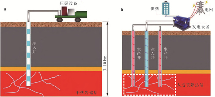
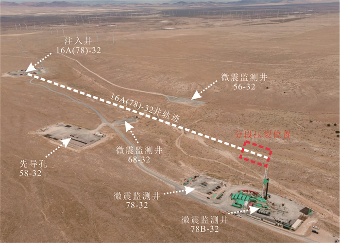
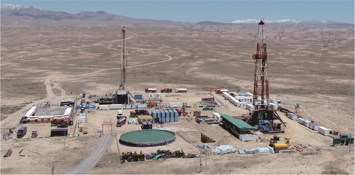
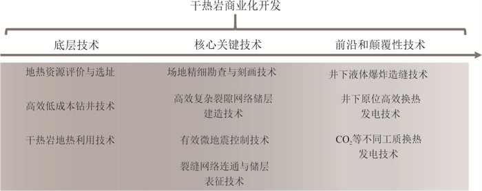
In this paper it summarizes the base technologies, key technologies, and game-changing technologies to promote the commercialization of hot dry rock (HDR) geothermal resources. The development of these technologies is very conducive to making new breakthroughs in HDR geothermal development, forming a batch of HDR exploitation demonstration areas, and supporting the adjustment of national energy structure and the realization of the "dual-carbon target" in China. According to the present situation of exploration, development and utilization of HDR at home and abroad, combined with the practice of scientific and technological exploration of HDR in Gonghe basin, the evaluation and site selection, efficient and low-cost drilling and geothermal utilization of HDR geothermal resources are defined as the base technologies. The key technologies include high-resolution exploration and characterization of HDR, efficient and complex fracture network reservoir creation, effective micro-seismic control, fracture network connectivity and reservoir characterization. The game-changing technologies include downhole liquid explosion fracture creation, downhole in-situ efficient heat transfer and power generation, CO2 and other working fluid for high-efficient power generation.
In this paper it summarizes the base technologies, key technologies, and game-changing technologies to promote the commercialization of hot dry rock (HDR) geothermal resources. The development of these technologies is very conducive to making new breakthroughs in HDR geothermal development, forming a batch of HDR exploitation demonstration areas, and supporting the adjustment of national energy structure and the realization of the "dual-carbon target" in China. According to the present situation of exploration, development and utilization of HDR at home and abroad, combined with the practice of scientific and technological exploration of HDR in Gonghe basin, the evaluation and site selection, efficient and low-cost drilling and geothermal utilization of HDR geothermal resources are defined as the base technologies. The key technologies include high-resolution exploration and characterization of HDR, efficient and complex fracture network reservoir creation, effective micro-seismic control, fracture network connectivity and reservoir characterization. The game-changing technologies include downhole liquid explosion fracture creation, downhole in-situ efficient heat transfer and power generation, CO2 and other working fluid for high-efficient power generation.
2024, 49(6): 2148-2157.
doi: 10.3799/dqkx.2023.074
Abstract:
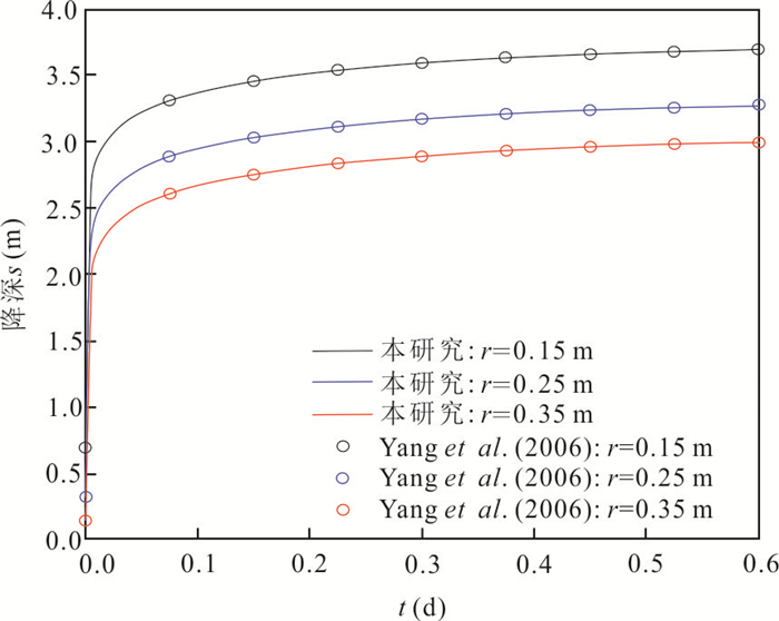
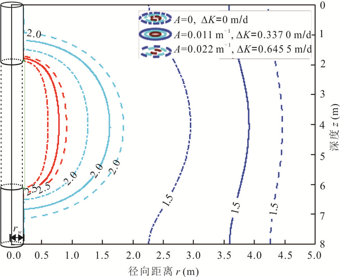
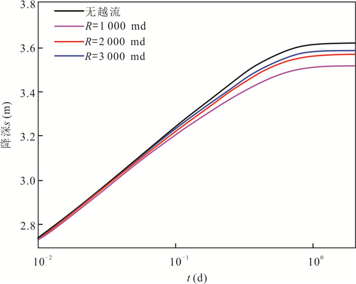
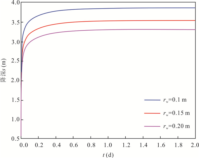
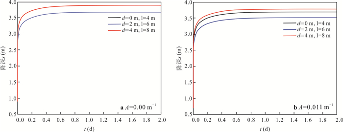
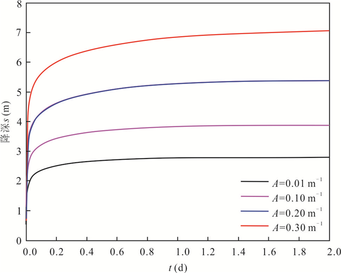
The traditional pumping test model typically assumes that the aquifer is a constant, whereas the actual aquifer frequently exhibits depth-dependent hydraulic conductivity due to geological effects and other factors. In this paper, it develops a mathematical model of pumping tests that takes into account leakage, wellbore storage effect, and depth-dependent hydraulic conductivity, and solves the semi-analytical solution, where the depth-dependent hydraulic conductivity represented by an exponential function. The results show that: the greater the attenuation coefficient (A) of depth-dependent hydraulic conductivity, the greater the drawdown in the wellbore and the greater the range of landing funnel caused by pumping. When the hydraulic conductivity decays with depth, the location of the well screen has a significant impact on the pumping test results, the drawdown at the wellbore with the well screen at the upper aquifer location is smaller than the drawdown at the wellbore with the well screen at the lower aquifer location; the estimated hydraulic conductivity is an approximation of the depth-decaying hydraulic conductivity based on drawdown at the wellbore by traditional pumping test model.
The traditional pumping test model typically assumes that the aquifer is a constant, whereas the actual aquifer frequently exhibits depth-dependent hydraulic conductivity due to geological effects and other factors. In this paper, it develops a mathematical model of pumping tests that takes into account leakage, wellbore storage effect, and depth-dependent hydraulic conductivity, and solves the semi-analytical solution, where the depth-dependent hydraulic conductivity represented by an exponential function. The results show that: the greater the attenuation coefficient (A) of depth-dependent hydraulic conductivity, the greater the drawdown in the wellbore and the greater the range of landing funnel caused by pumping. When the hydraulic conductivity decays with depth, the location of the well screen has a significant impact on the pumping test results, the drawdown at the wellbore with the well screen at the upper aquifer location is smaller than the drawdown at the wellbore with the well screen at the lower aquifer location; the estimated hydraulic conductivity is an approximation of the depth-decaying hydraulic conductivity based on drawdown at the wellbore by traditional pumping test model.


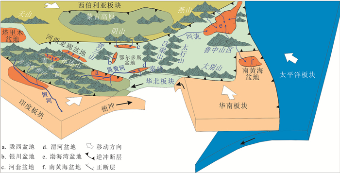
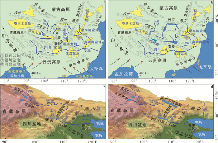
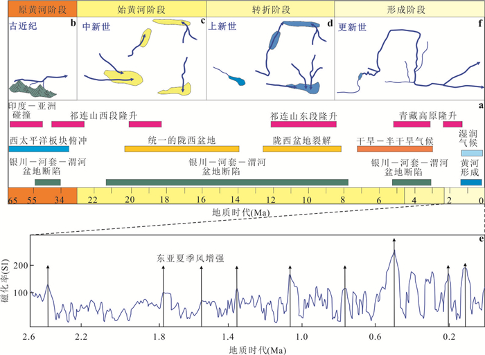
2024, 49(6): 2158-2185.
doi: 10.3799/dqkx.2023.124
Abstract:
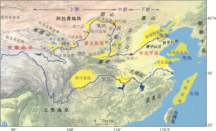
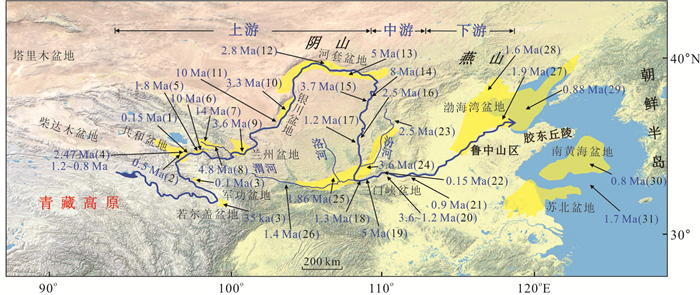
Rivers are one of the important geological forces that shape the land surface. Understanding the development history of big rivers is helpful for us to improve the efficiency of using big rivers, so as to promote the development of human society. The Yellow River is the mother river of China. Researchers have conducted extensive research on it in the past hundred years, however, there is no clear answer to the question of when it was formed and the specific evolution process. In view of this, on the basis of our previous research results, this paper extensively collected and collated the data published by domestic and foreign researchers to reconstruct the evolution process of the Yellow River during the Cenozoic era. The results show that: The proto-Yellow River, which flowed along the plateau boundary, developed in the northeastern part of the Tibetan Plateau in the Paleogene. In the Miocene, the eastern Qilian Mountains developed parallel rivers flowing into the depocenter of Longxi basin, and large rivers with different flow directions appeared in the north and south parts of the Jinshan Gorge. The Yellow River had not yet appeared in the Bohai Bay Basin and the South Yellow Sea Basin during the Miocene. The Yellow River entered the stage of segmental evolution in this time. In Pliocene, the Yellow River had already connected Xining basin, Lanzhou basin, Yinchuan Basin and Hetao basin, while Guide basin and Gonghe basin still had internal flow system. At this time, the upper reaches of the Yellow River had not penetrated into the deeper hinterland of the northeast section of the Tibetan Plateau. The Jinshan Gorge still has the Yellow River flowing south into Weihe basin and north into Hetao basin, respectively. The Sanmenxia basin is still occupied by large ancient lakes, and the Yellow River material does not appear in the Bohai Bay basin and the South Yellow Sea basin. Pliocene is an important turning stage for the Yellow River to complete its final connection. In the early Pleistocene, the Yellow River connected the upper, middle and lower reaches, similar to the current connection between the Tibetan Plateau, the Loess Plateau and the North China Plain. The Yellow River flowing east to the sea was formed at this time. In the Late Pleistocene, under the influence of climate change, all sections of the Yellow River entered a new stage of evolution, and some of the river channels were occupied by ancient lakes again. In the period of abundant precipitation, the river channels were connected again. The combination of structure and climate has an important influence on the development of the Yellow River. The maintenance of the high landform in the hinterland of river system is one of the preconditions for the development of river system. In particular, the uplift of the eastern Qilian Mountains in Miocene and Pliocene shaped the basic form of the Yellow River on the interior of the Tibetan Plateau. The uplifting of the Helan, Yin and Qinling Mountains around the Ordos Plateau have shaped the deep graben of Yinchuan, Hetao and Weihe River, which has become an important factor limiting the full transmission of the Yellow River in dry weather periods. The Quaternary is a period of frequent climate change in East Asia, and the final connection of the Yellow River is closely related to the process of climate change. Conversely, the study on the formation and evolution of the Yellow River can effectively reveal the tectonic evolution and climate change of the Cenozoic in North China.
Rivers are one of the important geological forces that shape the land surface. Understanding the development history of big rivers is helpful for us to improve the efficiency of using big rivers, so as to promote the development of human society. The Yellow River is the mother river of China. Researchers have conducted extensive research on it in the past hundred years, however, there is no clear answer to the question of when it was formed and the specific evolution process. In view of this, on the basis of our previous research results, this paper extensively collected and collated the data published by domestic and foreign researchers to reconstruct the evolution process of the Yellow River during the Cenozoic era. The results show that: The proto-Yellow River, which flowed along the plateau boundary, developed in the northeastern part of the Tibetan Plateau in the Paleogene. In the Miocene, the eastern Qilian Mountains developed parallel rivers flowing into the depocenter of Longxi basin, and large rivers with different flow directions appeared in the north and south parts of the Jinshan Gorge. The Yellow River had not yet appeared in the Bohai Bay Basin and the South Yellow Sea Basin during the Miocene. The Yellow River entered the stage of segmental evolution in this time. In Pliocene, the Yellow River had already connected Xining basin, Lanzhou basin, Yinchuan Basin and Hetao basin, while Guide basin and Gonghe basin still had internal flow system. At this time, the upper reaches of the Yellow River had not penetrated into the deeper hinterland of the northeast section of the Tibetan Plateau. The Jinshan Gorge still has the Yellow River flowing south into Weihe basin and north into Hetao basin, respectively. The Sanmenxia basin is still occupied by large ancient lakes, and the Yellow River material does not appear in the Bohai Bay basin and the South Yellow Sea basin. Pliocene is an important turning stage for the Yellow River to complete its final connection. In the early Pleistocene, the Yellow River connected the upper, middle and lower reaches, similar to the current connection between the Tibetan Plateau, the Loess Plateau and the North China Plain. The Yellow River flowing east to the sea was formed at this time. In the Late Pleistocene, under the influence of climate change, all sections of the Yellow River entered a new stage of evolution, and some of the river channels were occupied by ancient lakes again. In the period of abundant precipitation, the river channels were connected again. The combination of structure and climate has an important influence on the development of the Yellow River. The maintenance of the high landform in the hinterland of river system is one of the preconditions for the development of river system. In particular, the uplift of the eastern Qilian Mountains in Miocene and Pliocene shaped the basic form of the Yellow River on the interior of the Tibetan Plateau. The uplifting of the Helan, Yin and Qinling Mountains around the Ordos Plateau have shaped the deep graben of Yinchuan, Hetao and Weihe River, which has become an important factor limiting the full transmission of the Yellow River in dry weather periods. The Quaternary is a period of frequent climate change in East Asia, and the final connection of the Yellow River is closely related to the process of climate change. Conversely, the study on the formation and evolution of the Yellow River can effectively reveal the tectonic evolution and climate change of the Cenozoic in North China.
2024, 49(6): 2186-2198.
doi: 10.3799/dqkx.2022.107
Abstract:
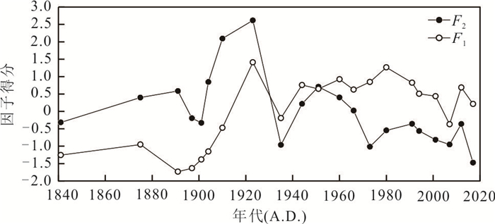
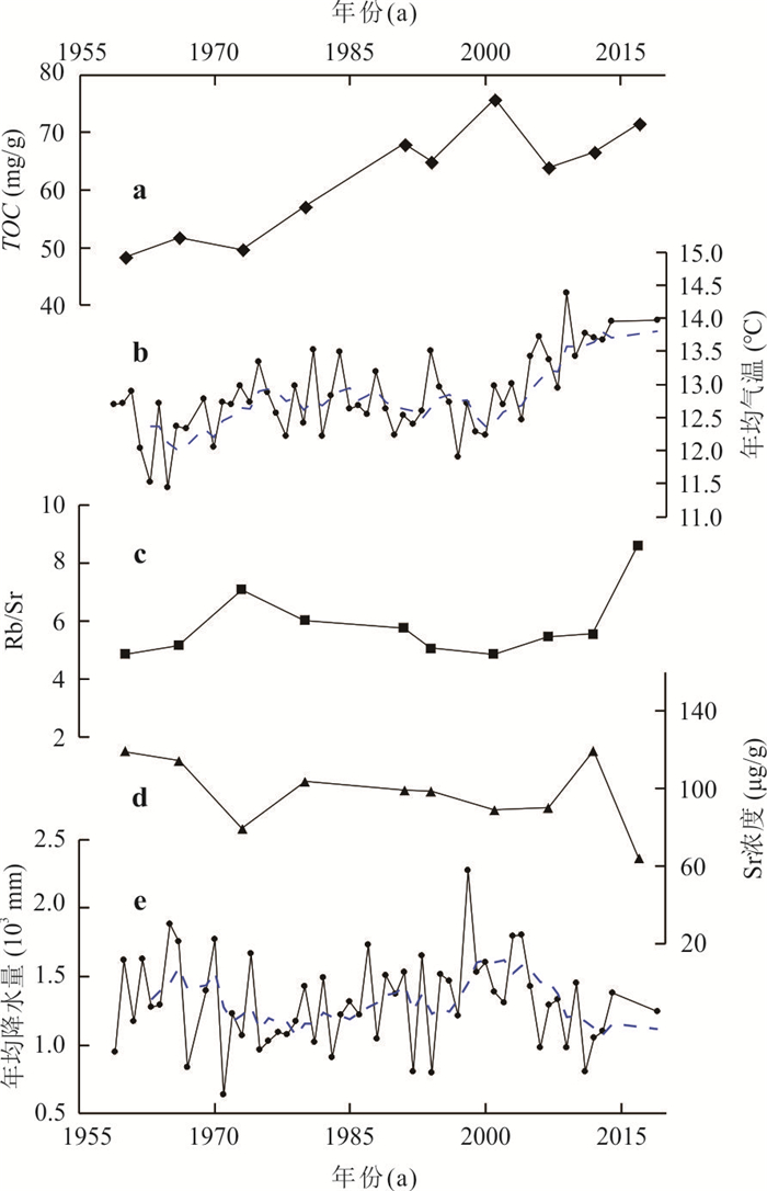
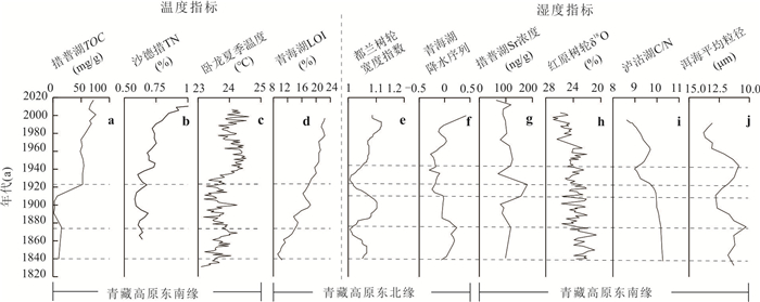
Small lakes distributed in the eastern edge of the Qinghai-Xizang plateau are less affected by human activities due to their special geographical location. Their sedimentary records have regional significance in response to climate and environmental changes, especially in restoring short-time scale climate and regional sedimentary environment. However, there are few studies involved at present. In this paper, trace element geochemical analysis was carried out on the sedimentary core samples of 45 cm in the center of Cuopu Lake in Ganzi Prefecture, Sichuan Province, and the local climate evolution process in the past 200 years was reconstructed. The results show that in recent 200 years, rare earth elements have basically the same longitudinal variation trend, and they all keep low values during the little ice age from 1841 to 1920, and reached the lowest value due to the indirect influence of the earthquake around 1890, and then increased with the warming of the climate. According to the principal component analysis of trace elements, the change of most trace elements is controlled by the erosion and weathering factors of the basin, which can reflect the strength of regional weathering; Rb, Ba, Sr are mainly controlled by humidity factor and can be used to restore the change of humidity. Combined with the change characteristics of various trace element environmental substitution indexes and sediment particle size composition, the climate and environment evolution process of Cuopu Lake from 1841 to 2017 is divided into 5 stages: cold-dry (1841—1904), mild-moist (1904—1923), mild-dry (1923—1944), warm-moist (1944—1966) and warm-dry (1967—2017).
Small lakes distributed in the eastern edge of the Qinghai-Xizang plateau are less affected by human activities due to their special geographical location. Their sedimentary records have regional significance in response to climate and environmental changes, especially in restoring short-time scale climate and regional sedimentary environment. However, there are few studies involved at present. In this paper, trace element geochemical analysis was carried out on the sedimentary core samples of 45 cm in the center of Cuopu Lake in Ganzi Prefecture, Sichuan Province, and the local climate evolution process in the past 200 years was reconstructed. The results show that in recent 200 years, rare earth elements have basically the same longitudinal variation trend, and they all keep low values during the little ice age from 1841 to 1920, and reached the lowest value due to the indirect influence of the earthquake around 1890, and then increased with the warming of the climate. According to the principal component analysis of trace elements, the change of most trace elements is controlled by the erosion and weathering factors of the basin, which can reflect the strength of regional weathering; Rb, Ba, Sr are mainly controlled by humidity factor and can be used to restore the change of humidity. Combined with the change characteristics of various trace element environmental substitution indexes and sediment particle size composition, the climate and environment evolution process of Cuopu Lake from 1841 to 2017 is divided into 5 stages: cold-dry (1841—1904), mild-moist (1904—1923), mild-dry (1923—1944), warm-moist (1944—1966) and warm-dry (1967—2017).

2024, 49(6): 2199-2212.
doi: 10.3799/dqkx.2022.473
Abstract:
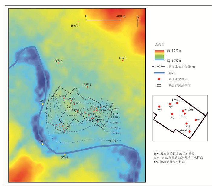
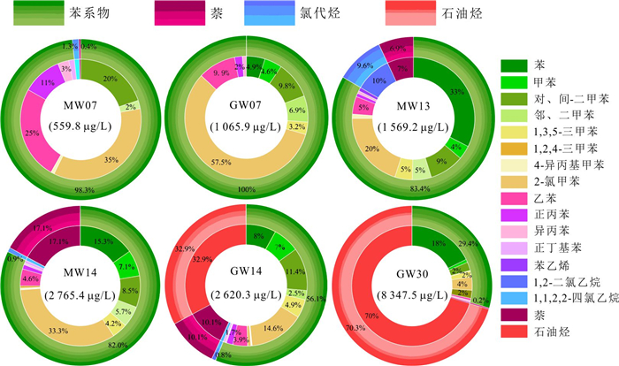
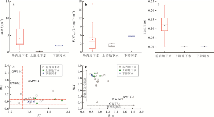
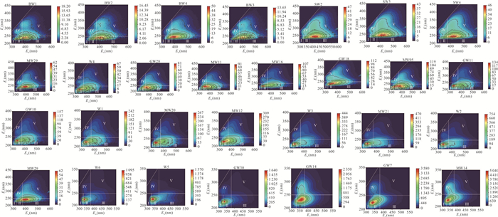
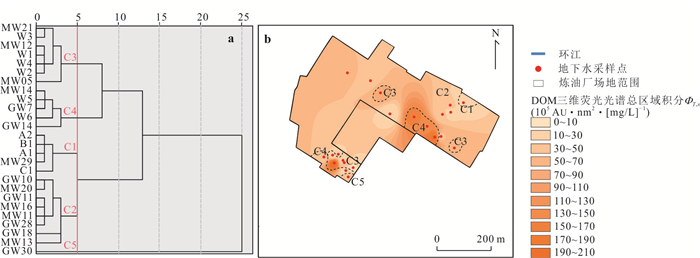
The excitation-emission matrix (EEMs) fluorescence spectroscopy of dissolved organic matter (DOM) has been widely used in monitoring and warning of water pollution. To clarify the indicator of EEMs fluorescence fingerprint on groundwater organic pollution at refinery sites, the EEMs characteristics of DOM and spatial distribution of organic pollution in groundwater was studied at a typical refinery-polluted site by EEMs regional integration, correlation analysis and hierarchical clustering. The EEMs results show that DOM in groundwater of the polluted site had significant fluorescence spectral fingerprint as oil contaminants. The constituents of DOM in the polluted groundwater were quantified by EMMs regional integration based on fluorescence of model compounds. The normalized volumetric integration of regions Ⅰ and Ⅱ representing benzene series and petroleum hydrocarbons accounts for 55%-88% of the total volumetric integration of all regions, which is consistent with GC-MS results of organic compositions. The hierarchical clustering on the similarity of EEMs can effectively distinguish the types of groundwater organic pollution and their spatial distribution in the polluted site. The correlation analyses between normalized volumetric integration of EEMs regions and organic components, spectra parameters and water chemistry further suggest that the fluorescence EEMs fingerprint of DOM can effectively reveal organic pollution and effect on geochemistry of groundwater at the refinery site, indicating as an effective tracer to monitor and warn groundwater organic pollution.
The excitation-emission matrix (EEMs) fluorescence spectroscopy of dissolved organic matter (DOM) has been widely used in monitoring and warning of water pollution. To clarify the indicator of EEMs fluorescence fingerprint on groundwater organic pollution at refinery sites, the EEMs characteristics of DOM and spatial distribution of organic pollution in groundwater was studied at a typical refinery-polluted site by EEMs regional integration, correlation analysis and hierarchical clustering. The EEMs results show that DOM in groundwater of the polluted site had significant fluorescence spectral fingerprint as oil contaminants. The constituents of DOM in the polluted groundwater were quantified by EMMs regional integration based on fluorescence of model compounds. The normalized volumetric integration of regions Ⅰ and Ⅱ representing benzene series and petroleum hydrocarbons accounts for 55%-88% of the total volumetric integration of all regions, which is consistent with GC-MS results of organic compositions. The hierarchical clustering on the similarity of EEMs can effectively distinguish the types of groundwater organic pollution and their spatial distribution in the polluted site. The correlation analyses between normalized volumetric integration of EEMs regions and organic components, spectra parameters and water chemistry further suggest that the fluorescence EEMs fingerprint of DOM can effectively reveal organic pollution and effect on geochemistry of groundwater at the refinery site, indicating as an effective tracer to monitor and warn groundwater organic pollution.
2024, 49(6): 2213-2226.
doi: 10.3799/dqkx.2024.037
Abstract:
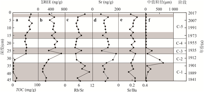
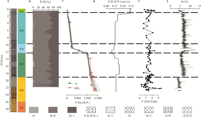
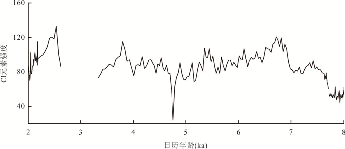
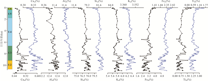
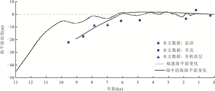
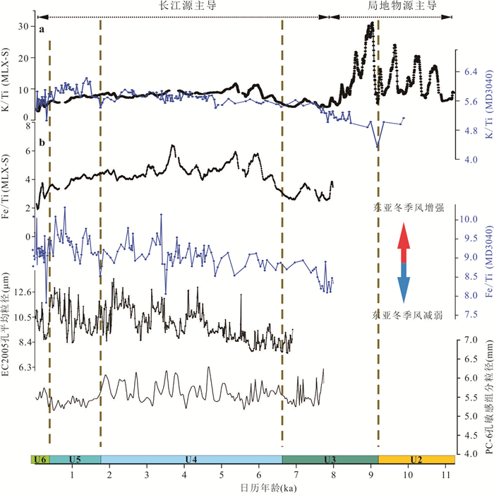
To investigate the depositional environment evolution and controlling factors of a mountainous river estuary during the Holocene, in this study it selected a drilling core (MLX-S) from the river mouth of Mulanxi, a tidal-controlled mountainous river in central Fujian Province, China. The core was subjected to radiocarbon dating, optically stimulated luminescence dating, grain size analysis, XRF core scanning, and ICP-OES elemental measurements. During the Holocene, the Mulanxi estuary experienced a transition from fluvial facies to riparian marsh facies, shallow marine facies, and finally to tide-controlled estuarine facies. The sedimentary environment evolution was primarily influenced by relative sea-level changes in the study area. The relative sea level along the coast of central Fujian is around 9.0 ka and about -20 m. Subsequently, the marine transgression reached the strongest and the maximum sea level occurred around 5.8 ka, followed by a slow decline till the present. High-resolution XRF core scanning data, after calibration of element relative intensities, can indicate sediment provenance and paleoenvironmental changes. The downcore variation of K/Ti ratio suggests that since 8.8 ka, the sediments in the Mulanxi Estuary were mainly derived from a mixture source of local basin erosion and fine offshore material from the Changjiang (Yangtze River). The core Fe/Ti ratio reached its peak in four strong East Asian winter monsoon periods of about 3.6 ka, 4.3 ka, 5.4 ka and 6.0 ka, corresponding to periods of strong East Asian winter monsoon, which is consistent with the sedimentary records on the East China Sea inner shelf and tightly related to the changes of Min-Zhe coastal current intensity. This study reveals the typical river-sea interaction in the tide-controlled mountainous estuaries along the southeastern coast of China, and suggests the complex source-sink transport processes of Changjiang-derived fine sediments on the continental shelf driven by the Holocene monsoon and sea level changes. This study also promotes the potential application of XRF core scanning in the continental margin where has the unique sedimentary dynamics and environmental changes.
To investigate the depositional environment evolution and controlling factors of a mountainous river estuary during the Holocene, in this study it selected a drilling core (MLX-S) from the river mouth of Mulanxi, a tidal-controlled mountainous river in central Fujian Province, China. The core was subjected to radiocarbon dating, optically stimulated luminescence dating, grain size analysis, XRF core scanning, and ICP-OES elemental measurements. During the Holocene, the Mulanxi estuary experienced a transition from fluvial facies to riparian marsh facies, shallow marine facies, and finally to tide-controlled estuarine facies. The sedimentary environment evolution was primarily influenced by relative sea-level changes in the study area. The relative sea level along the coast of central Fujian is around 9.0 ka and about -20 m. Subsequently, the marine transgression reached the strongest and the maximum sea level occurred around 5.8 ka, followed by a slow decline till the present. High-resolution XRF core scanning data, after calibration of element relative intensities, can indicate sediment provenance and paleoenvironmental changes. The downcore variation of K/Ti ratio suggests that since 8.8 ka, the sediments in the Mulanxi Estuary were mainly derived from a mixture source of local basin erosion and fine offshore material from the Changjiang (Yangtze River). The core Fe/Ti ratio reached its peak in four strong East Asian winter monsoon periods of about 3.6 ka, 4.3 ka, 5.4 ka and 6.0 ka, corresponding to periods of strong East Asian winter monsoon, which is consistent with the sedimentary records on the East China Sea inner shelf and tightly related to the changes of Min-Zhe coastal current intensity. This study reveals the typical river-sea interaction in the tide-controlled mountainous estuaries along the southeastern coast of China, and suggests the complex source-sink transport processes of Changjiang-derived fine sediments on the continental shelf driven by the Holocene monsoon and sea level changes. This study also promotes the potential application of XRF core scanning in the continental margin where has the unique sedimentary dynamics and environmental changes.
2024, 49(6): 2227-2241.
doi: 10.3799/dqkx.2022.507
Abstract:
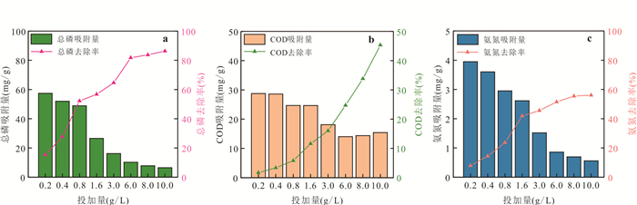
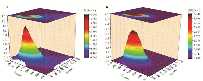
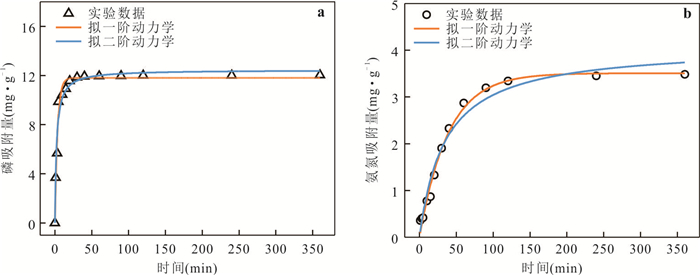
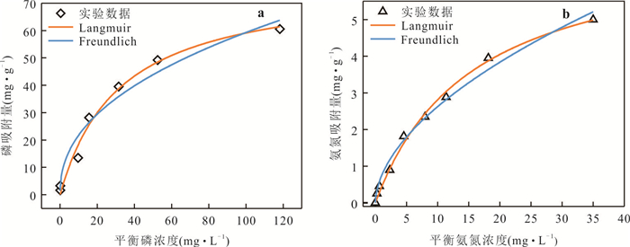
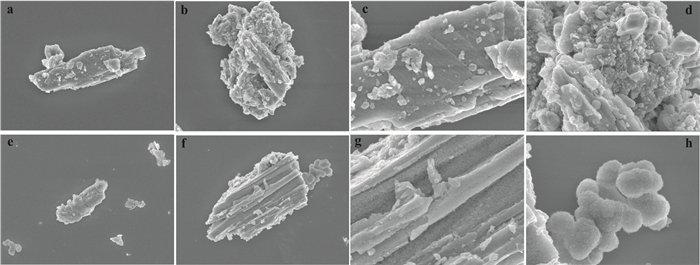
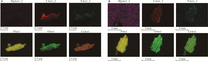
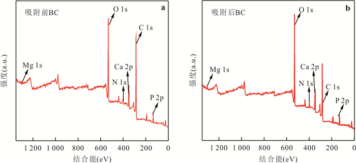
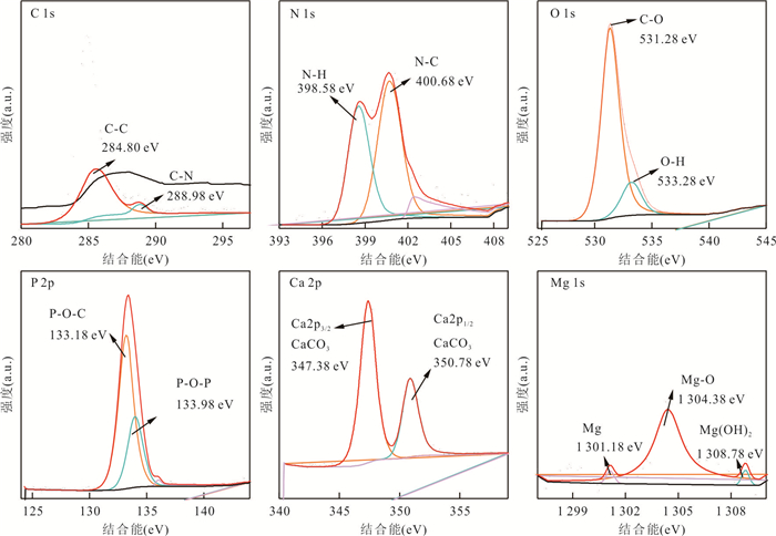
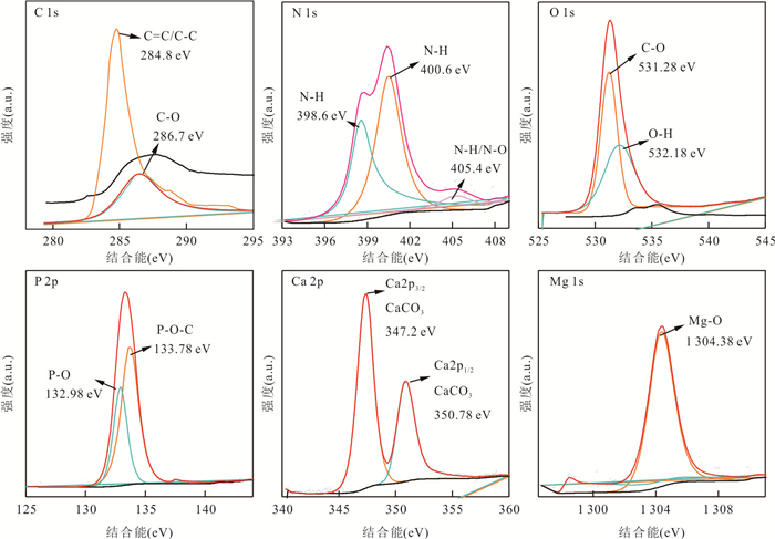
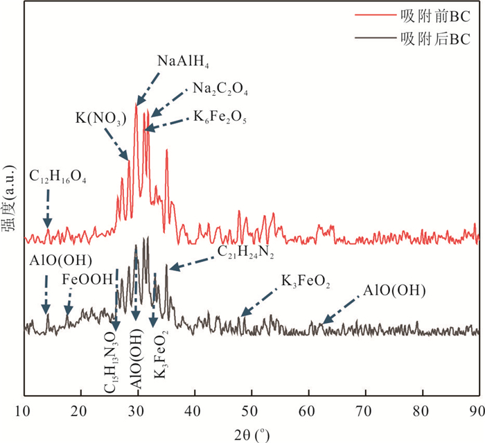
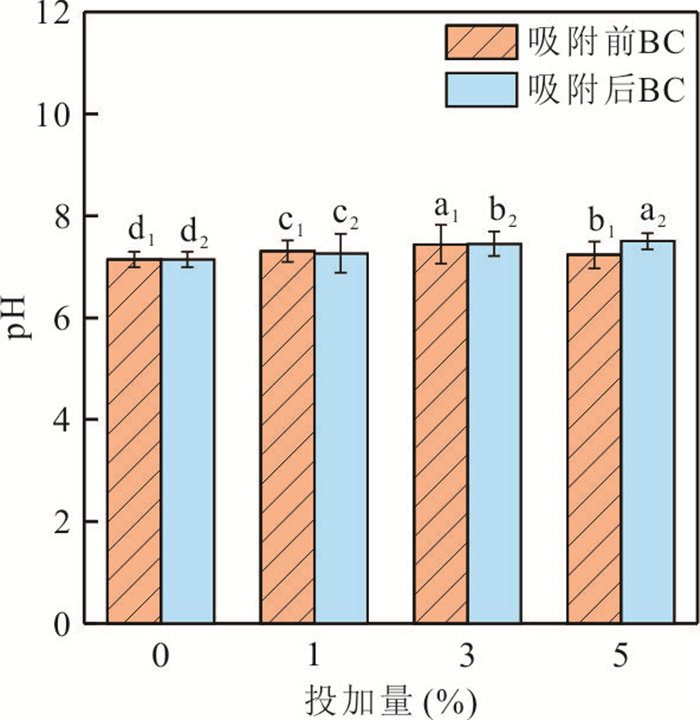
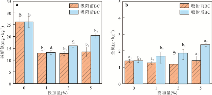
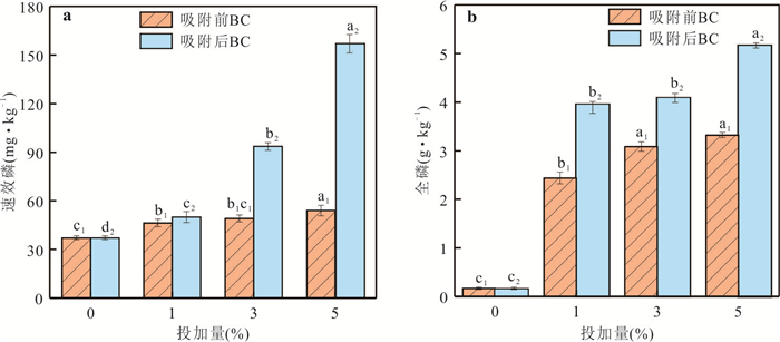
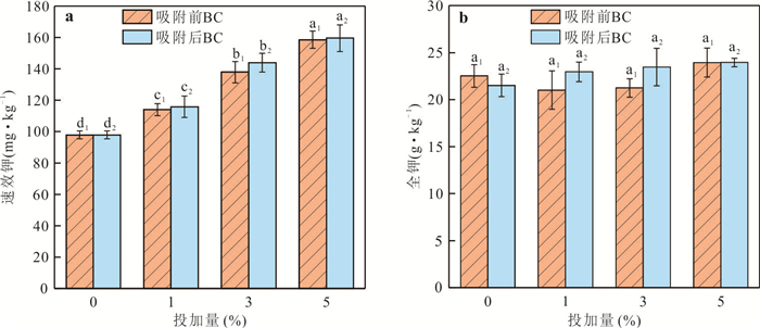
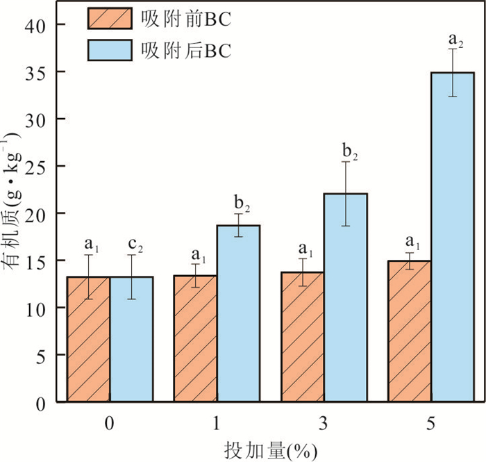
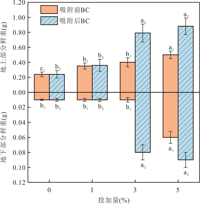
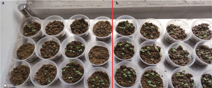
In order to solve the problem of resource utilization of brewing biogas residue, the biochar prepared by brewing biogas residue was added into garden soil. A batch incubation and absorption experiments were carried out with the amended soils to study the improvement of biochar addition on adsorption availability and soil physicochemical properties. Results show that: the high calcium biochar prepared by oxygen limited pyrolysis method at 700 ℃ for 1.5 h behaved best with initial pH 10, the removal rates of COD, NH4+-N and TP in actual wastewater by adding 10 g·L-1 biogas biochar can reach 45.29%, 56.10% and 86.33%, respectively. Langmuir isothermal model and pseudo-first-order kinetic equation were more consistent with its adsorption characteristics, indicating the physical adsorption were the main adsorption modes. The contents of C, N, P and O elements on the biochar surface increased significantly with new N-H and P=O groups generated after the adsorption. The available phosphorus, available potassium and organic matter in soil were significantly increased with 5% of adsorbed biochar added which could promote the growth of Chinese cabbage well. This study explored a 'one treatment but two uses' approach, which provides an application prospect for the disposal and resource recovery of biogas residue.
In order to solve the problem of resource utilization of brewing biogas residue, the biochar prepared by brewing biogas residue was added into garden soil. A batch incubation and absorption experiments were carried out with the amended soils to study the improvement of biochar addition on adsorption availability and soil physicochemical properties. Results show that: the high calcium biochar prepared by oxygen limited pyrolysis method at 700 ℃ for 1.5 h behaved best with initial pH 10, the removal rates of COD, NH4+-N and TP in actual wastewater by adding 10 g·L-1 biogas biochar can reach 45.29%, 56.10% and 86.33%, respectively. Langmuir isothermal model and pseudo-first-order kinetic equation were more consistent with its adsorption characteristics, indicating the physical adsorption were the main adsorption modes. The contents of C, N, P and O elements on the biochar surface increased significantly with new N-H and P=O groups generated after the adsorption. The available phosphorus, available potassium and organic matter in soil were significantly increased with 5% of adsorbed biochar added which could promote the growth of Chinese cabbage well. This study explored a 'one treatment but two uses' approach, which provides an application prospect for the disposal and resource recovery of biogas residue.

2024, 49(6): 2242-2252.
doi: 10.3799/dqkx.2024.039
Abstract:
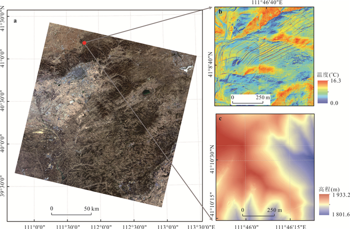
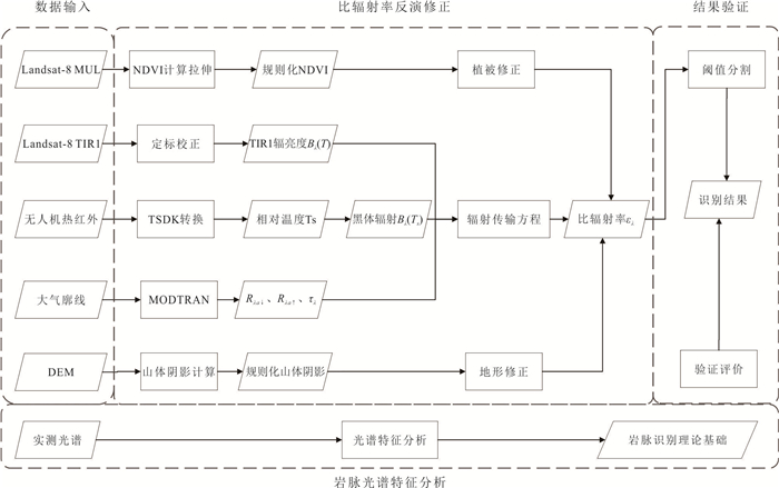
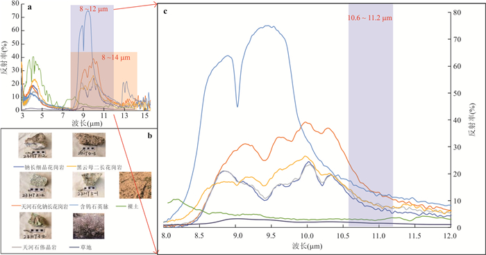
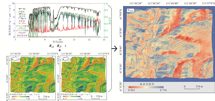
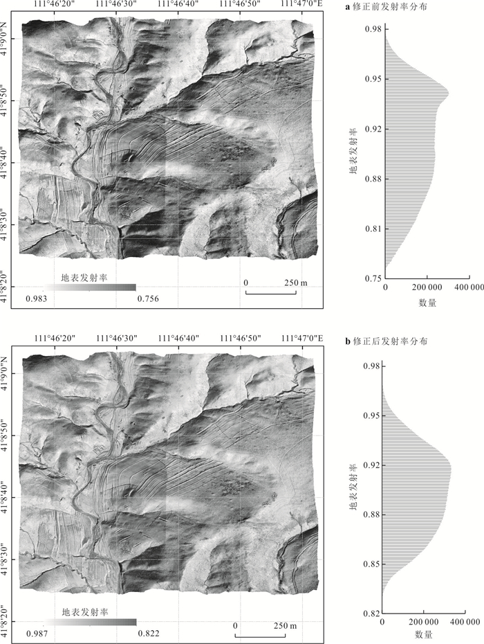
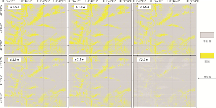
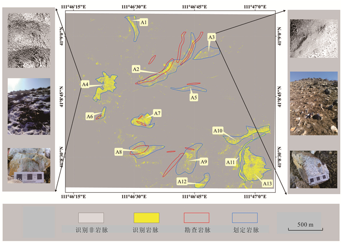
Remote sensing identification of rare metal deposit dikes in the north margin of North China block has important practical needs and theoretical significance. In view of the technical difficulties of vein recognition and the special geological background of the study area, it proposes a "Space-Sky- Ground" synchronous thermal infrared remote sensing algorithm for Nb-Ta polymetallic deposit vein recognition to assist the identification of metallogenic veins. The algorithm uses landsat-8 satellite data and UAV thermal infrared data collected synchronously as the main data source to calculate and correct the surface specific emissivity. Combined with the emission characteristics of Tianhe Petrochemical albite granite and threshold segmentation method, 13 dike development areas were delimited and verified in the field. The results show that the accuracy and reliability of the proposed algorithm are high, and the "Space-Sky-Ground" synchronous thermal infrared remote sensing can be used to identify rare metal dikes in Hutoushan area. This study has provided guidance for the exploration of niobium-tantalum deposits in the study area, and will also provide a useful reference for the remote sensing detection and identification of rare metal deposits.
Remote sensing identification of rare metal deposit dikes in the north margin of North China block has important practical needs and theoretical significance. In view of the technical difficulties of vein recognition and the special geological background of the study area, it proposes a "Space-Sky- Ground" synchronous thermal infrared remote sensing algorithm for Nb-Ta polymetallic deposit vein recognition to assist the identification of metallogenic veins. The algorithm uses landsat-8 satellite data and UAV thermal infrared data collected synchronously as the main data source to calculate and correct the surface specific emissivity. Combined with the emission characteristics of Tianhe Petrochemical albite granite and threshold segmentation method, 13 dike development areas were delimited and verified in the field. The results show that the accuracy and reliability of the proposed algorithm are high, and the "Space-Sky-Ground" synchronous thermal infrared remote sensing can be used to identify rare metal dikes in Hutoushan area. This study has provided guidance for the exploration of niobium-tantalum deposits in the study area, and will also provide a useful reference for the remote sensing detection and identification of rare metal deposits.
2024, 49(6): 2253-2276.
doi: 10.3799/dqkx.2023.205
Abstract:
Mars, as a planet in the solar system similar to Earth, once had a history of active water activities. However, its current thin atmosphere and cold, arid climate make it difficult for liquid water to exist on the Martian surface. Water on modern Mars is mostly present in the form of ice at the polar regions and mid-latitude areas, forming various types of depositional landforms. With the growing number of deep space exploration missions, the water-ice environment and habitability of Mars have attracted more attention. In this article it focuses on polar ice caps, glacial landforms in mid-latitudes and sublimation landforms of shallow subsurface water-ice in mid-latitudes. It introduces and analyzes their morphological characteristics, distribution, formation mechanisms, and their coupling with the climate. The formation of mid-latitude water-ice landforms on Mars is, due to the migration of polar water-ice to the mid-latitude surface when Mars is at a high obliquity, transitioning to a cold glacial period in those regions. Conversely, this leads to an expansion of polar ice cap regions. Thus, the periodic changes in Martian obliquity have driven climate variations and the subsequent redistribution of water-ice on the Martian surface, characterized by a cyclic enrichment from polar to mid-high latitude regions. By summarizing the distribution characteristics of water-ice on Mars, our understanding of the Martian water-ice environment is improved. Also, several prospects on the future research directions are provided based on the current research status of Martian water-ice. The Martian water-ice landforms are closely linked to the habitable environment and potential forms of life on Mars. Studying water-ice on Mars can help us gain insights into Martian climate evolution history, habitability conditions, and provide support for future Mars exploration missions.
Mars, as a planet in the solar system similar to Earth, once had a history of active water activities. However, its current thin atmosphere and cold, arid climate make it difficult for liquid water to exist on the Martian surface. Water on modern Mars is mostly present in the form of ice at the polar regions and mid-latitude areas, forming various types of depositional landforms. With the growing number of deep space exploration missions, the water-ice environment and habitability of Mars have attracted more attention. In this article it focuses on polar ice caps, glacial landforms in mid-latitudes and sublimation landforms of shallow subsurface water-ice in mid-latitudes. It introduces and analyzes their morphological characteristics, distribution, formation mechanisms, and their coupling with the climate. The formation of mid-latitude water-ice landforms on Mars is, due to the migration of polar water-ice to the mid-latitude surface when Mars is at a high obliquity, transitioning to a cold glacial period in those regions. Conversely, this leads to an expansion of polar ice cap regions. Thus, the periodic changes in Martian obliquity have driven climate variations and the subsequent redistribution of water-ice on the Martian surface, characterized by a cyclic enrichment from polar to mid-high latitude regions. By summarizing the distribution characteristics of water-ice on Mars, our understanding of the Martian water-ice environment is improved. Also, several prospects on the future research directions are provided based on the current research status of Martian water-ice. The Martian water-ice landforms are closely linked to the habitable environment and potential forms of life on Mars. Studying water-ice on Mars can help us gain insights into Martian climate evolution history, habitability conditions, and provide support for future Mars exploration missions.
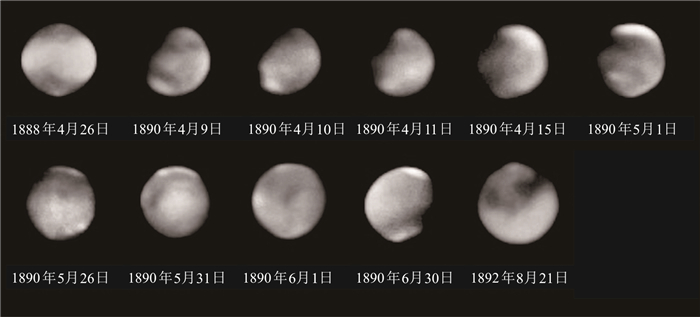
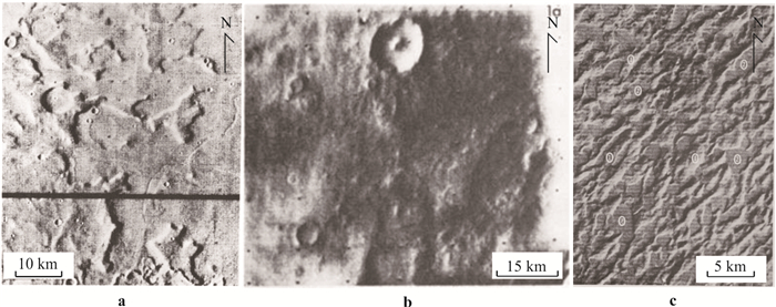
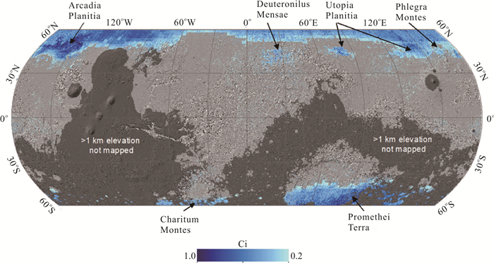

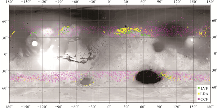
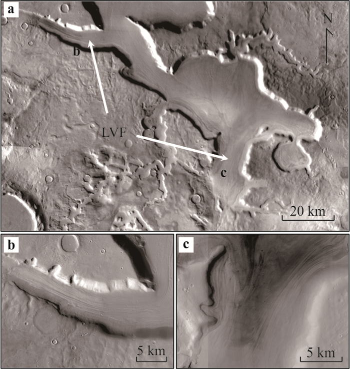
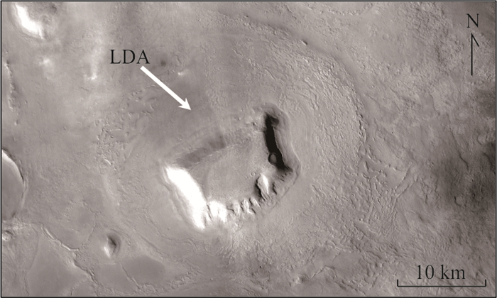
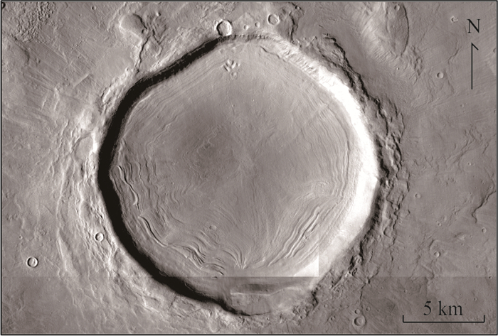
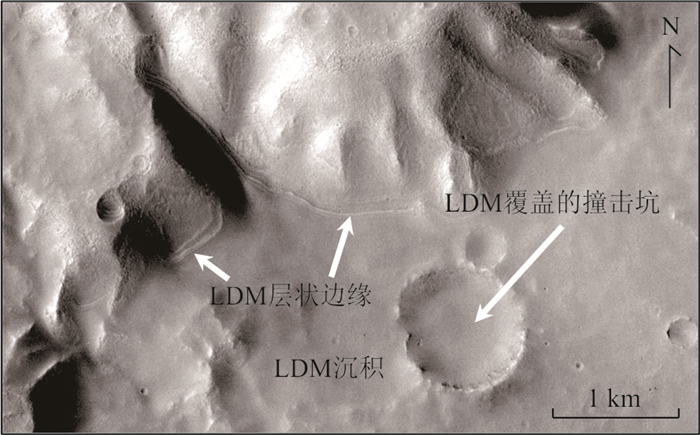
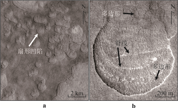
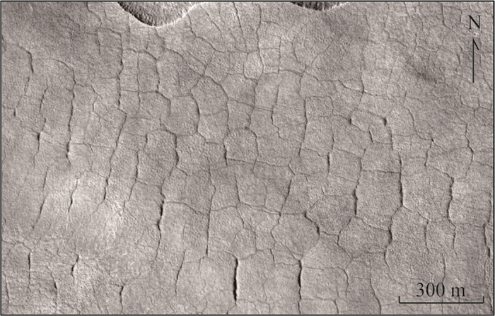
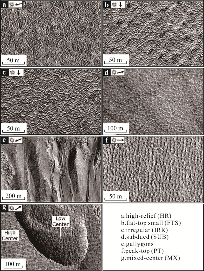
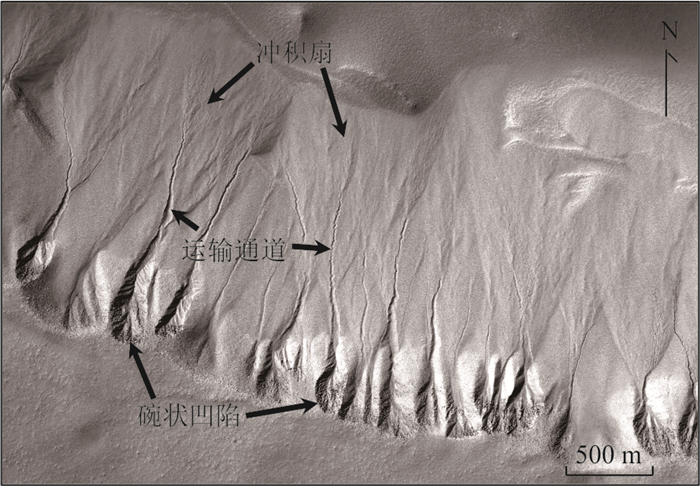
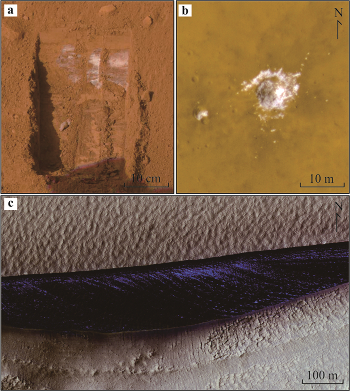
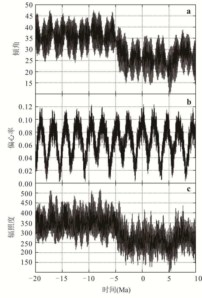
2024, 49(6): 2277-2295.
doi: 10.3799/dqkx.2023.052
Abstract:
The Guanshan Biota is an in situ preserved Lower Cambrian (Series 2, Stage 4) Burgess shale-type Konservat-Lagerstätten from East Yunnan, South China, which is composed of multiple metazoan groups. Recent studies revealed that Guanshan Biota is dominated by brachiopods on relative abundance. Those brachiopods formed a geographically widespread phenomenon of many monospecific or paucispecific shell-bed concentrations during the Cambrian Age 4. The repaired shell damages and encrusted kleptoparasites on brachiopod shells reveal complex ecological relationships of benthic communities. Associations of sessile epibenthic brachiopods encrusted with kleptoparasitic tube-dwelling worms, infaunal paleoscolecidans, and swimming Tuzoia were discovered on the same micro-bedding plane. It represents a unique, brachiopod-supported, well-developed vertically stratified benthic community, which is composed of the different phyla that fill multiple ecological niches, exhibiting a complex trophic network and community structure with increased utilization of eco-space during the Cambrian Age 4. Furthermore, the fossil record shows an unusual ecological transition from trilobite- to brachiopod-dominated communities from the Guanshan Biota for the first time. Generally, the Chengjiang, Malong and Guanshan assemblages share similar taxa, however, the main trilobite and brachiopod assemblages are unique. This indicates an important ecological event of faunal overturn and benthic community succession during the Cambrian Epoch 2 in East Yunnan. In Situ preserved, brachiopod-dominated Guanshan Biota with complex ecosystem provides a unique view of the seafloor during the Early Cambrian. Paleoecology, especially biological interactions between other benthic taxa in the Guanshan Biota are required in the future. Temporal changes of paleoenvironment during the Cambrian Explosion and key factors that affect benthic community succession are still unclear in East Yunnan. Further studies will provide important evidence for Cambrian Series 2 global stratigraphic correlation.
The Guanshan Biota is an in situ preserved Lower Cambrian (Series 2, Stage 4) Burgess shale-type Konservat-Lagerstätten from East Yunnan, South China, which is composed of multiple metazoan groups. Recent studies revealed that Guanshan Biota is dominated by brachiopods on relative abundance. Those brachiopods formed a geographically widespread phenomenon of many monospecific or paucispecific shell-bed concentrations during the Cambrian Age 4. The repaired shell damages and encrusted kleptoparasites on brachiopod shells reveal complex ecological relationships of benthic communities. Associations of sessile epibenthic brachiopods encrusted with kleptoparasitic tube-dwelling worms, infaunal paleoscolecidans, and swimming Tuzoia were discovered on the same micro-bedding plane. It represents a unique, brachiopod-supported, well-developed vertically stratified benthic community, which is composed of the different phyla that fill multiple ecological niches, exhibiting a complex trophic network and community structure with increased utilization of eco-space during the Cambrian Age 4. Furthermore, the fossil record shows an unusual ecological transition from trilobite- to brachiopod-dominated communities from the Guanshan Biota for the first time. Generally, the Chengjiang, Malong and Guanshan assemblages share similar taxa, however, the main trilobite and brachiopod assemblages are unique. This indicates an important ecological event of faunal overturn and benthic community succession during the Cambrian Epoch 2 in East Yunnan. In Situ preserved, brachiopod-dominated Guanshan Biota with complex ecosystem provides a unique view of the seafloor during the Early Cambrian. Paleoecology, especially biological interactions between other benthic taxa in the Guanshan Biota are required in the future. Temporal changes of paleoenvironment during the Cambrian Explosion and key factors that affect benthic community succession are still unclear in East Yunnan. Further studies will provide important evidence for Cambrian Series 2 global stratigraphic correlation.