2011 Vol. 36, No. 1
Display Method:
2011, 36(1): 1-11.
doi: 10.3799/dqkx.2011.001
 PDF 3339KB
Abstract:
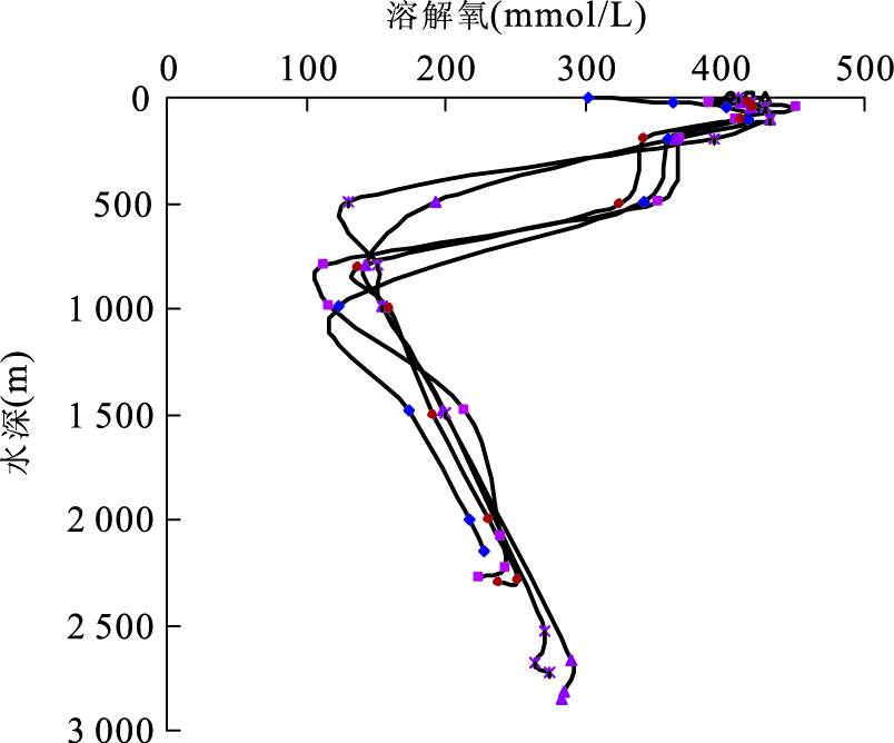
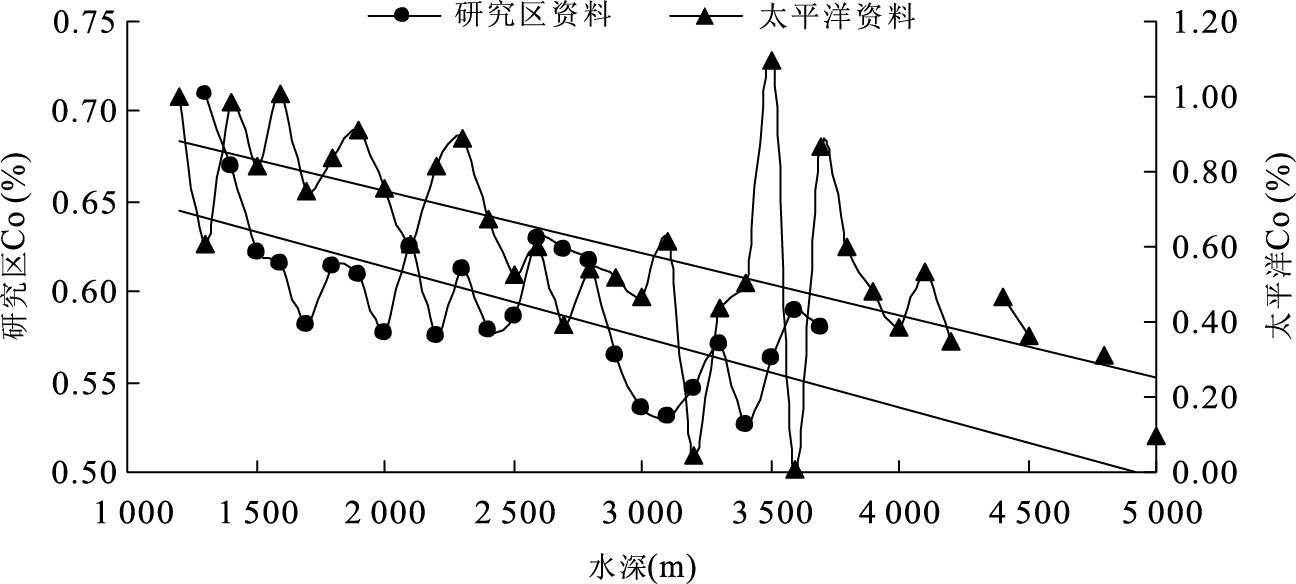
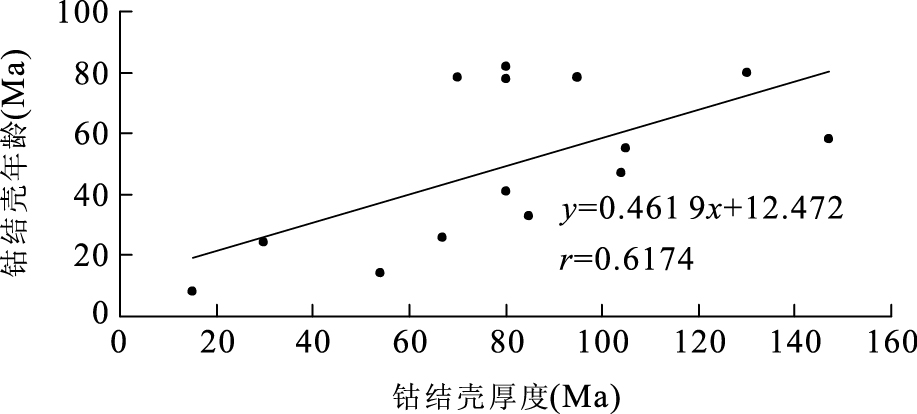
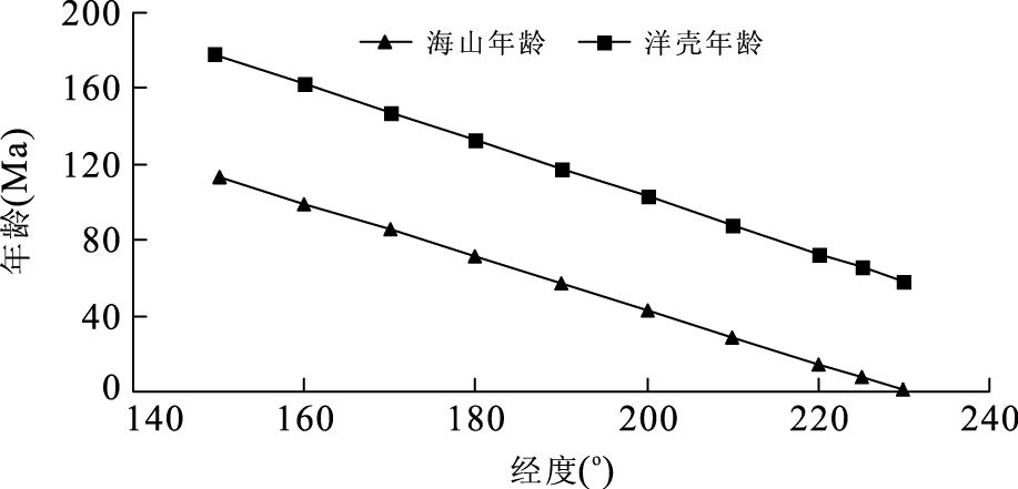
Marine Co-rich crusts are important as potential mineral resources for Co, Ni, Cu, Mn, and other metals, as well as for the paleoenvironment signals stored in their stratigraphic layers. The higher Co, Ni and Pt contents of crusts relative to pelagic polymetallic nodules and hydrothermal deposits have made seamount crusts a potential target for commercial exploitation. In order to obtain the amount of Co-rich crust resources on seamounts in the Pacific, based on the surveying data of Co-rich crust resources on seamounts in the western Pacific by means of dredge hauling, a series of detailed research on the distribution of Co-rich crust resources and parameter index for delineation of Co-rich crust resources on seamounts in the Pacific, each seamount is endowed with the crust thickness according to its height and age of ocean crust and consequent amount of dry crust resources is at first calculated to be (507.06-1 014.11)×108 t, (111.15-222.29)×108 t manganese, (3.04-6.08)×108 t cobalt, (2.23-4.46)×108 t nickel, (0.66-1.32)×108 t copper, and distributed area of crusts on seamounts in Pacific is 2 062 862 km2. By means of analyzing relationships between Co-fluxes with amount of Co-deposited in the crust and crust thickness, the endowed crust thickness accounts for 6.10%-12.20% of the theoretical deductive thickness, which is close to Ku's conclusion of "the crusts were actually growing for 4% of their lifetime". It is shows that the endowed number of crust thickness is reasonable and the obtained resource amount is reliable. This paper provides a new method for estimating the amount of Co-rich crust resources on seamounts in a whole deep-sea basin.
Marine Co-rich crusts are important as potential mineral resources for Co, Ni, Cu, Mn, and other metals, as well as for the paleoenvironment signals stored in their stratigraphic layers. The higher Co, Ni and Pt contents of crusts relative to pelagic polymetallic nodules and hydrothermal deposits have made seamount crusts a potential target for commercial exploitation. In order to obtain the amount of Co-rich crust resources on seamounts in the Pacific, based on the surveying data of Co-rich crust resources on seamounts in the western Pacific by means of dredge hauling, a series of detailed research on the distribution of Co-rich crust resources and parameter index for delineation of Co-rich crust resources on seamounts in the Pacific, each seamount is endowed with the crust thickness according to its height and age of ocean crust and consequent amount of dry crust resources is at first calculated to be (507.06-1 014.11)×108 t, (111.15-222.29)×108 t manganese, (3.04-6.08)×108 t cobalt, (2.23-4.46)×108 t nickel, (0.66-1.32)×108 t copper, and distributed area of crusts on seamounts in Pacific is 2 062 862 km2. By means of analyzing relationships between Co-fluxes with amount of Co-deposited in the crust and crust thickness, the endowed crust thickness accounts for 6.10%-12.20% of the theoretical deductive thickness, which is close to Ku's conclusion of "the crusts were actually growing for 4% of their lifetime". It is shows that the endowed number of crust thickness is reasonable and the obtained resource amount is reliable. This paper provides a new method for estimating the amount of Co-rich crust resources on seamounts in a whole deep-sea basin.

2011, 36(1): 12-16.
doi: 10.3799/dqkx.2011.002
Abstract:
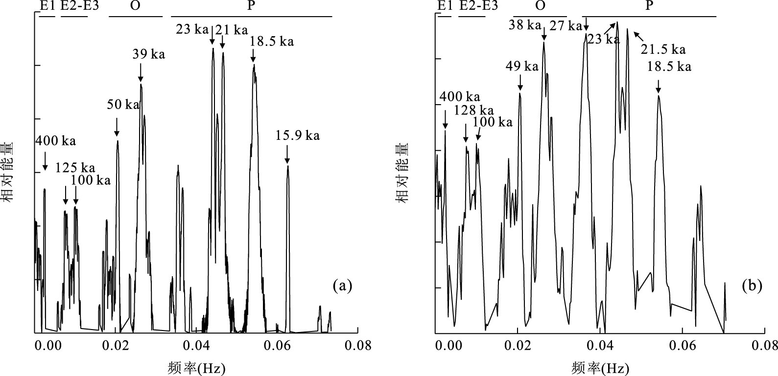
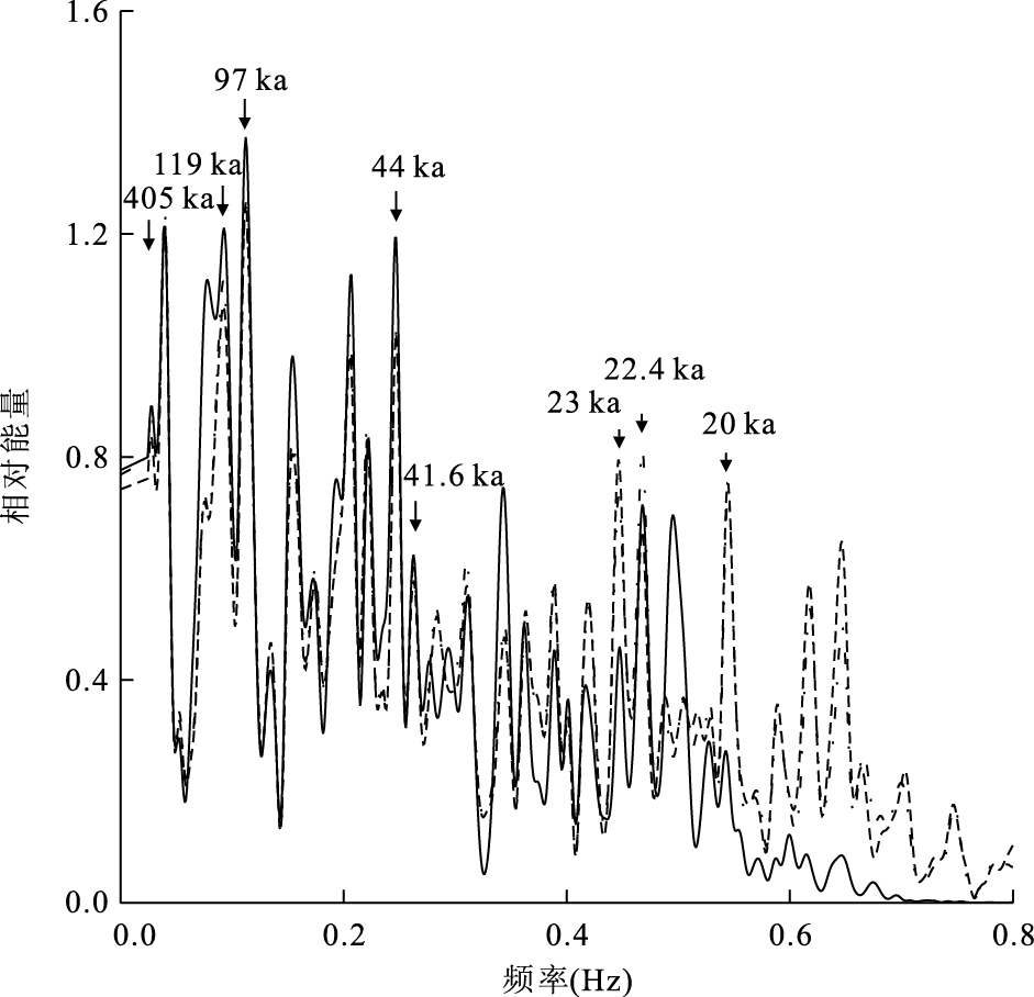
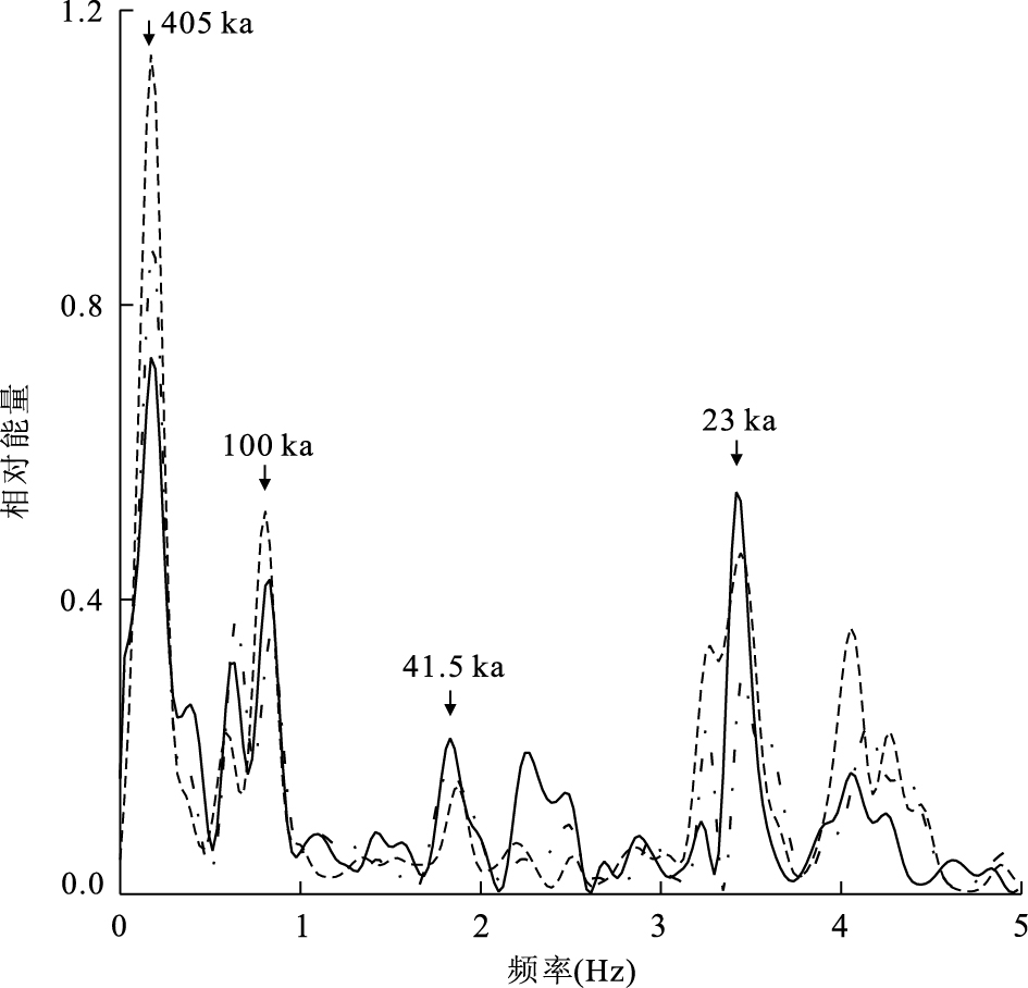
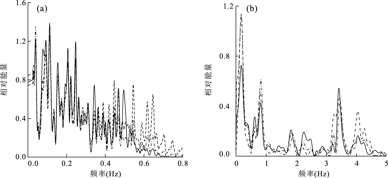
In recent years, cyclostratigraphy has been successfully applied to dating strata and recongnizing the possible astronomical forcing on major geological events. Sampling is one of the most important routines in cyclostratigraphic analysis to get the suitable geophysical or geochemical paleoclimate proxies. However, the workload will be significantly increased and random noises or other non-climatic noises will be introduced if the sampling frequency is too high; on the contrary, a lower sampling frequency may make it difficult to recognize Milankovitch signals in successions. In order to identify an optimal sampling interval, we used theoretic daily insolation data of time intervals of 80-100 Ma and two geological datasets to estimate each power spectra at three sampling intervals (high resolution, one quarter and half of one precession cycle), and then compared corresponding spectra analysis results. As a result, under the condition of satisfying the sampling theorem, sampling interval which equals to half of a precession cycle is the optimal sampling interval for cyclostratigraphic analysis. All Milankovitch signals can be identified and at the same time the workload is the least by using this optimal sampling interval. This interval should be determined according to the mean accumulation rate of the target successions during field sampling.
In recent years, cyclostratigraphy has been successfully applied to dating strata and recongnizing the possible astronomical forcing on major geological events. Sampling is one of the most important routines in cyclostratigraphic analysis to get the suitable geophysical or geochemical paleoclimate proxies. However, the workload will be significantly increased and random noises or other non-climatic noises will be introduced if the sampling frequency is too high; on the contrary, a lower sampling frequency may make it difficult to recognize Milankovitch signals in successions. In order to identify an optimal sampling interval, we used theoretic daily insolation data of time intervals of 80-100 Ma and two geological datasets to estimate each power spectra at three sampling intervals (high resolution, one quarter and half of one precession cycle), and then compared corresponding spectra analysis results. As a result, under the condition of satisfying the sampling theorem, sampling interval which equals to half of a precession cycle is the optimal sampling interval for cyclostratigraphic analysis. All Milankovitch signals can be identified and at the same time the workload is the least by using this optimal sampling interval. This interval should be determined according to the mean accumulation rate of the target successions during field sampling.
2011, 36(1): 17-32.
doi: 10.3799/dqkx.2011.003
Abstract:
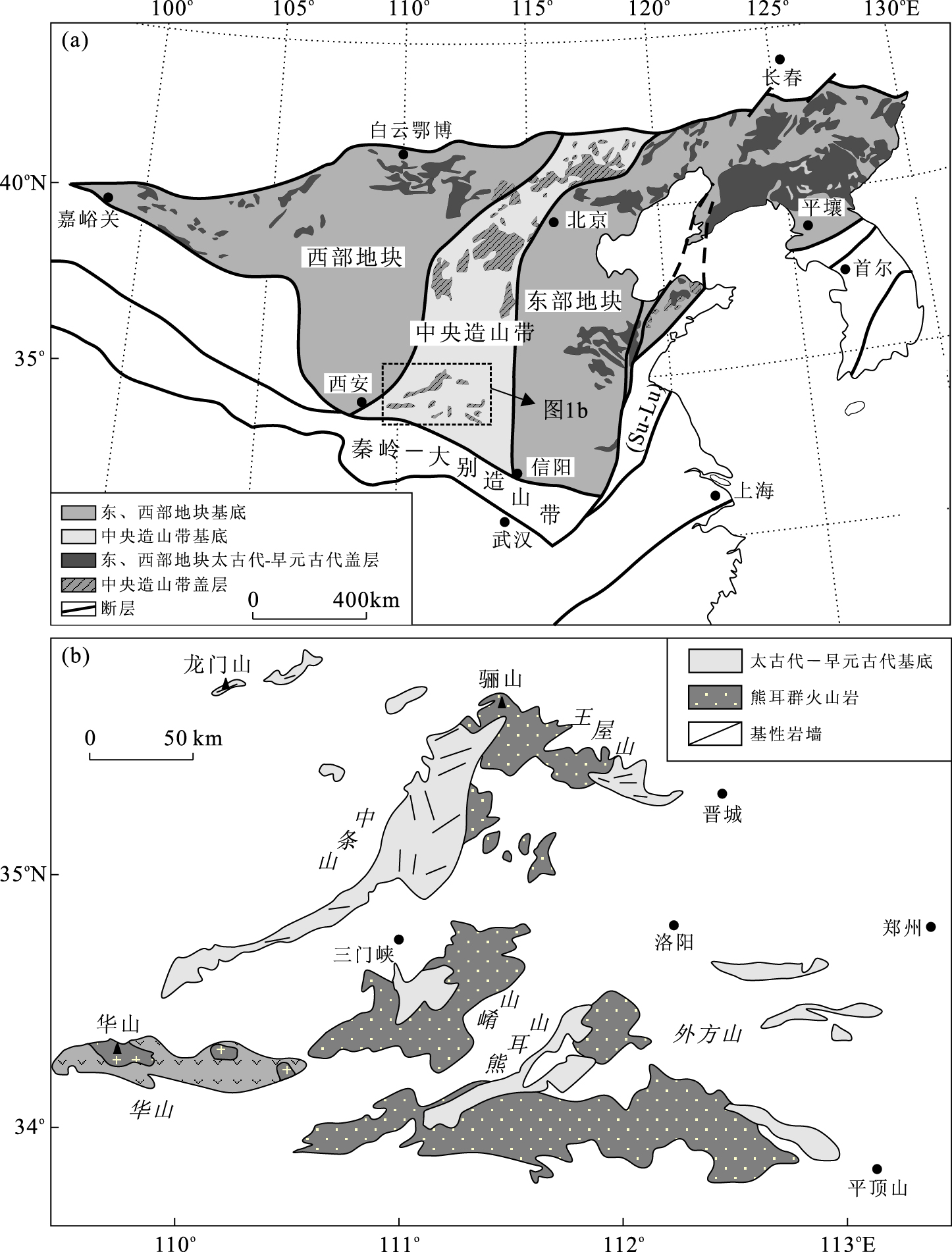
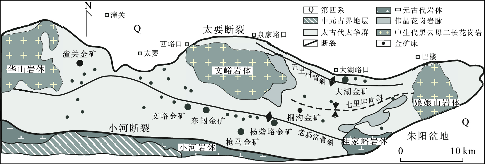
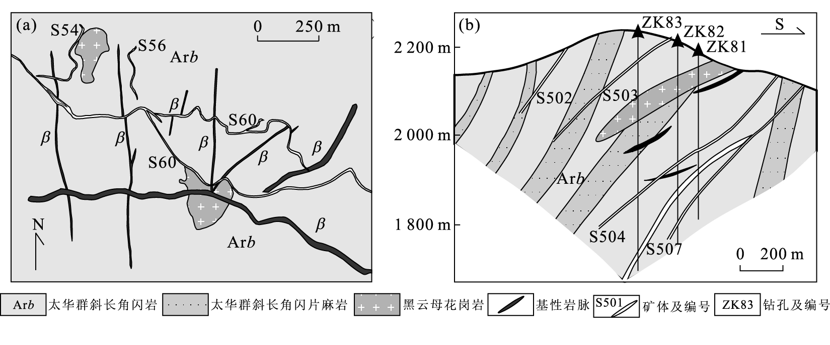
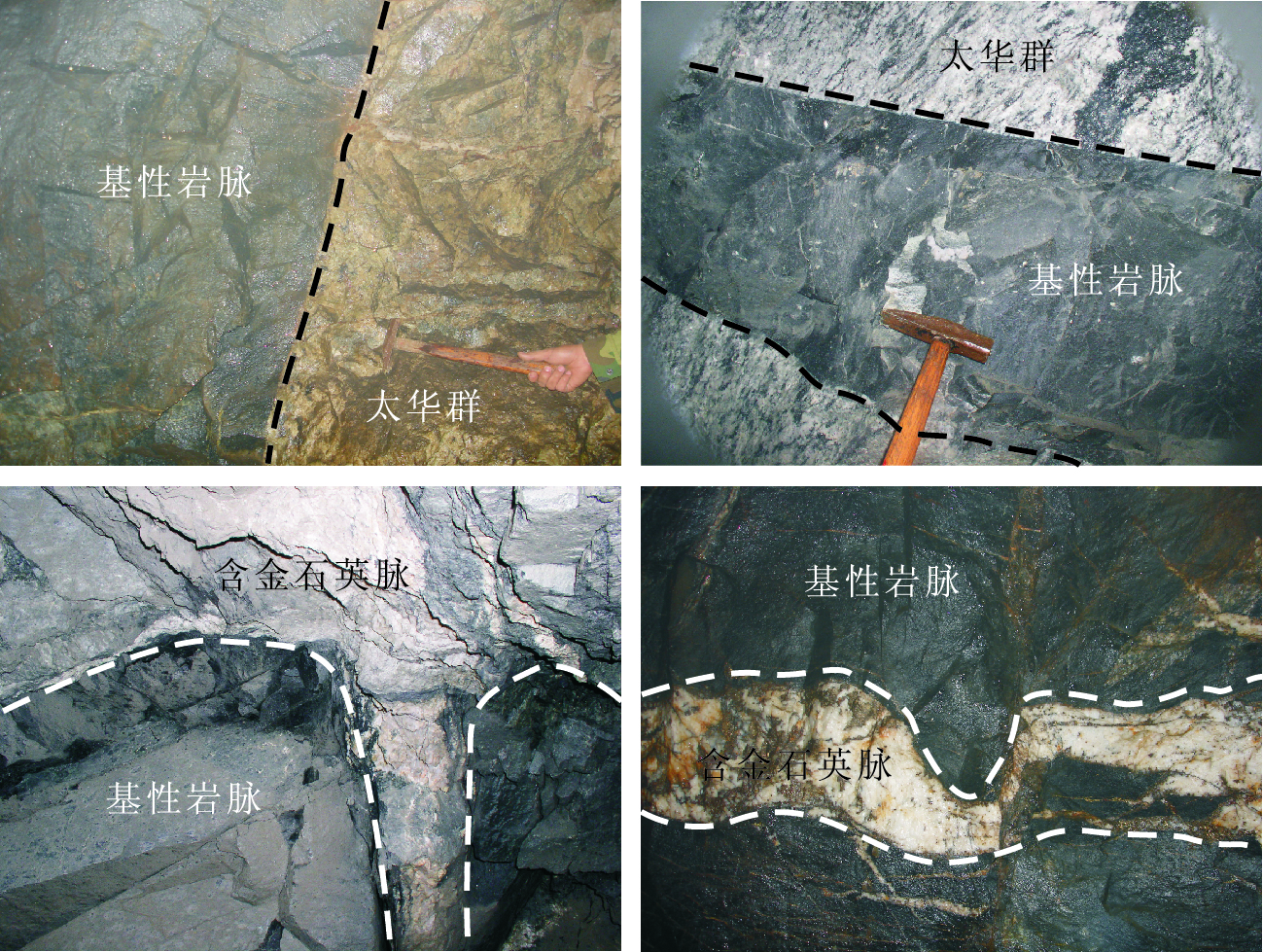
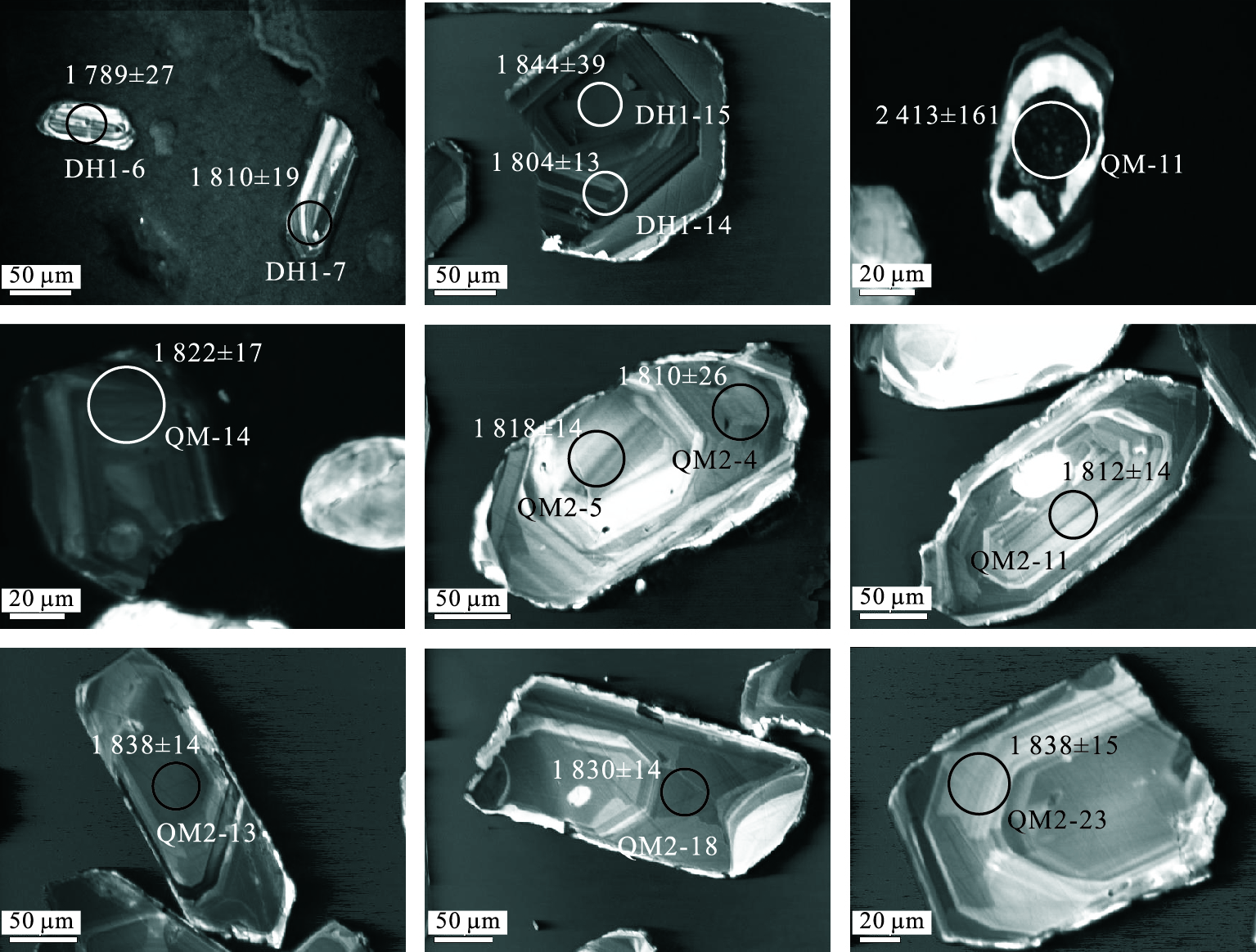
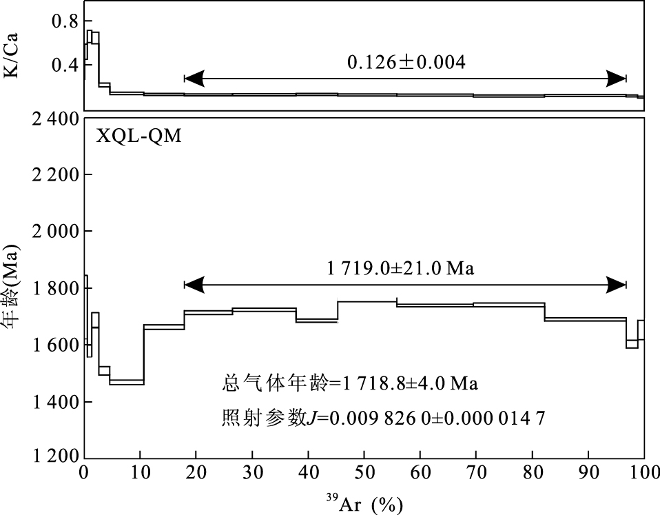
Lode gold deposit is the most economically important type of gold deposits worldwide. It commonly occurs in Archean to Paleoproterozoioc metamorphic terrains and has close spatial relationship with mafic dykes. However, it is still in dispute whether mafic dykes and gold mineralization are genetically related. In this paper, we present LA-ICPMS zircon U-Pb and biotite 40Ar-39Ar ages of four mafic dikes samples collected from three major gold deposits (Dongchuang, Dahu and Qiangma deposits) in the Xiaoqinling gold district, southern margin of the North China craton. Four samples yielded a consistent zircon LA-ICPMS age (207Pb/206Pb 1 819±10 Ma) and a slightly younger 40Ar/39Ar plateau age (1 719.0±21.0 Ma) of biotite. Our results suggest that: (1) numerous mafic dikes in the Xiaoqinling gold district formed in Paleoproterozoioc, in an extensional setting after the collision between the eastern and western blocks of the North China craton at ca. 1.85 Ga; (2) previous whole rock K-Ar and Rb-Sr ages (187.6-75.9 Ma) which are significantly younger than our ages represent thermal perturbation (or cooling ages) caused by Mesozoic tectonic-thermal event. Recent geochronological studies show that the majority of gold deposits formed in Early Cretaceous (130-120 Ma) in the Xiaoqinling district. Therefore, the mineralization event had no relationship with Paleoproterozoic mafic dykes although they were spatially associated. However, this study does not rule out the possibility of existence of Mesozoic mafic dykes in the Xiaoqinling area, which may be very important for the understanding of the metallogeny and regional tectonic setting.
Lode gold deposit is the most economically important type of gold deposits worldwide. It commonly occurs in Archean to Paleoproterozoioc metamorphic terrains and has close spatial relationship with mafic dykes. However, it is still in dispute whether mafic dykes and gold mineralization are genetically related. In this paper, we present LA-ICPMS zircon U-Pb and biotite 40Ar-39Ar ages of four mafic dikes samples collected from three major gold deposits (Dongchuang, Dahu and Qiangma deposits) in the Xiaoqinling gold district, southern margin of the North China craton. Four samples yielded a consistent zircon LA-ICPMS age (207Pb/206Pb 1 819±10 Ma) and a slightly younger 40Ar/39Ar plateau age (1 719.0±21.0 Ma) of biotite. Our results suggest that: (1) numerous mafic dikes in the Xiaoqinling gold district formed in Paleoproterozoioc, in an extensional setting after the collision between the eastern and western blocks of the North China craton at ca. 1.85 Ga; (2) previous whole rock K-Ar and Rb-Sr ages (187.6-75.9 Ma) which are significantly younger than our ages represent thermal perturbation (or cooling ages) caused by Mesozoic tectonic-thermal event. Recent geochronological studies show that the majority of gold deposits formed in Early Cretaceous (130-120 Ma) in the Xiaoqinling district. Therefore, the mineralization event had no relationship with Paleoproterozoic mafic dykes although they were spatially associated. However, this study does not rule out the possibility of existence of Mesozoic mafic dykes in the Xiaoqinling area, which may be very important for the understanding of the metallogeny and regional tectonic setting.

2011, 36(1): 33-42.
doi: 10.3799/dqkx.2011.004
Abstract:
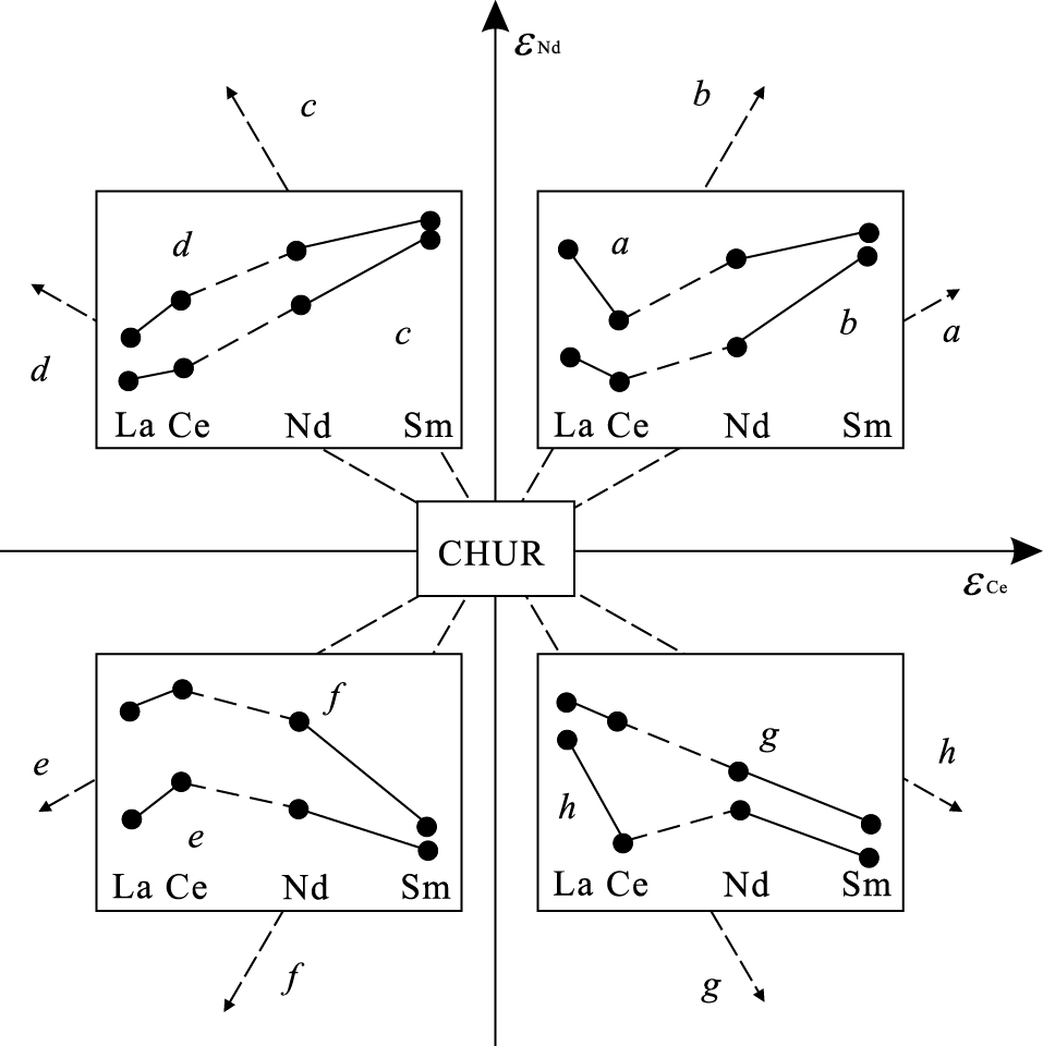
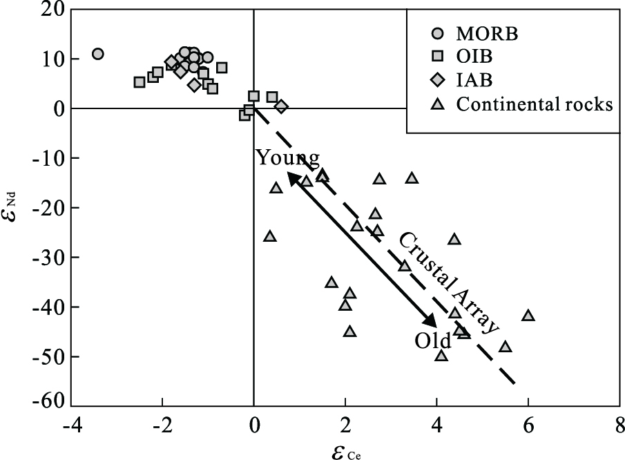
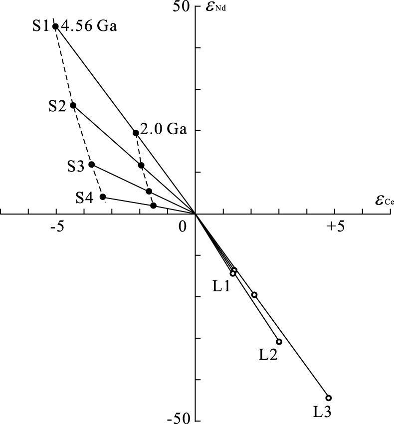
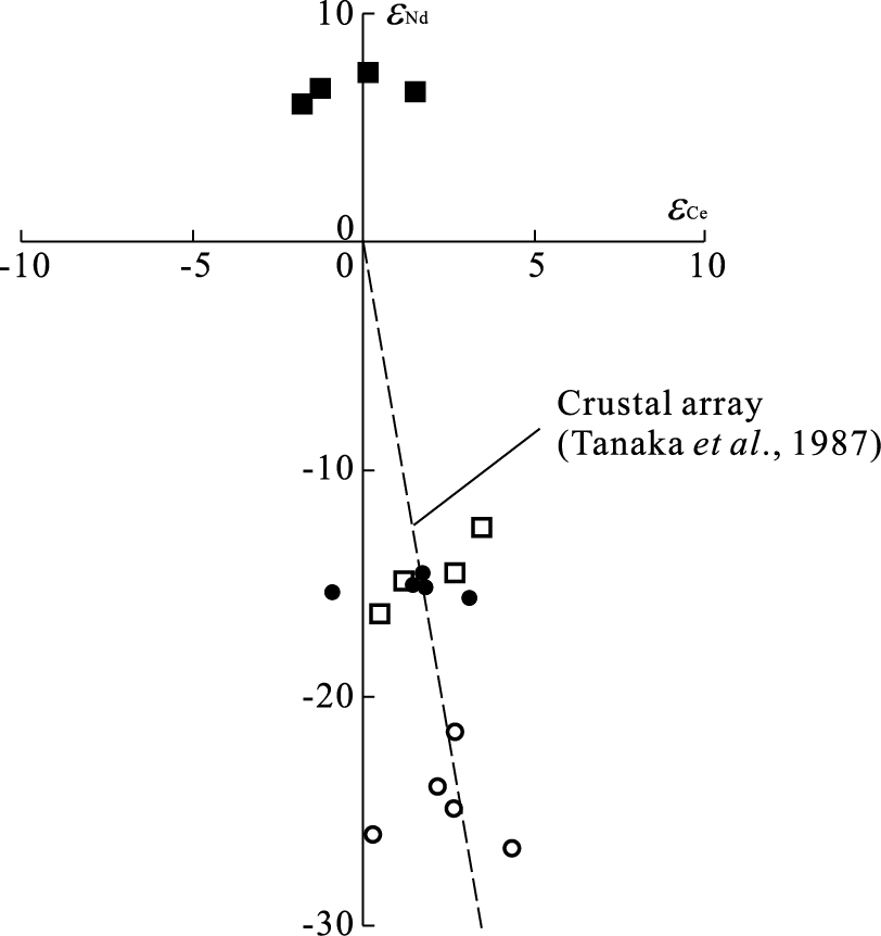
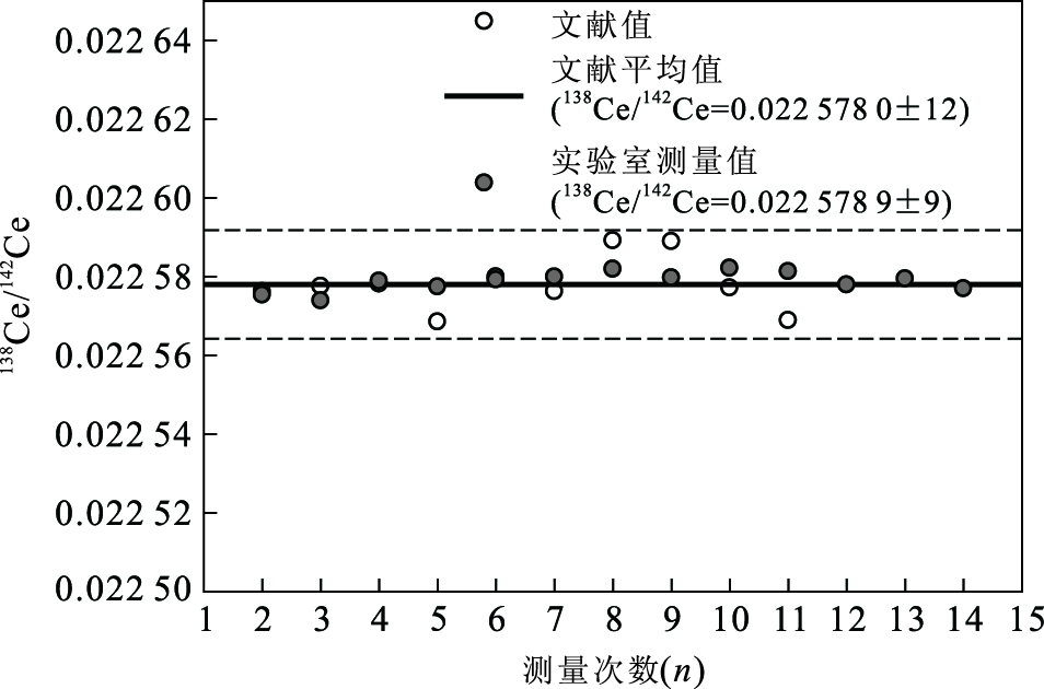
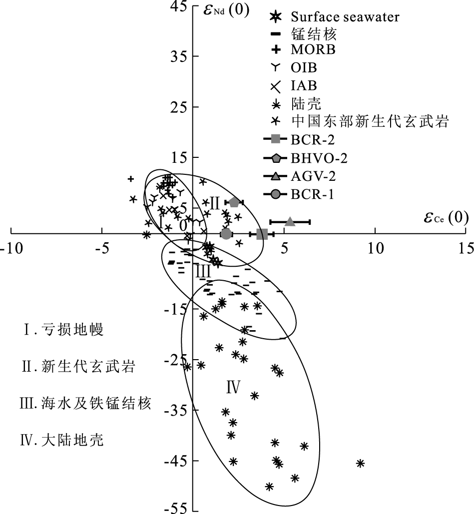
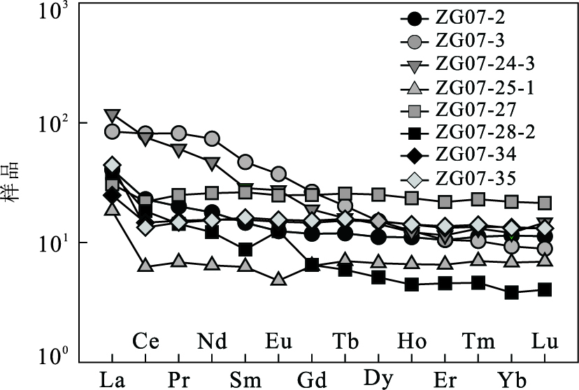
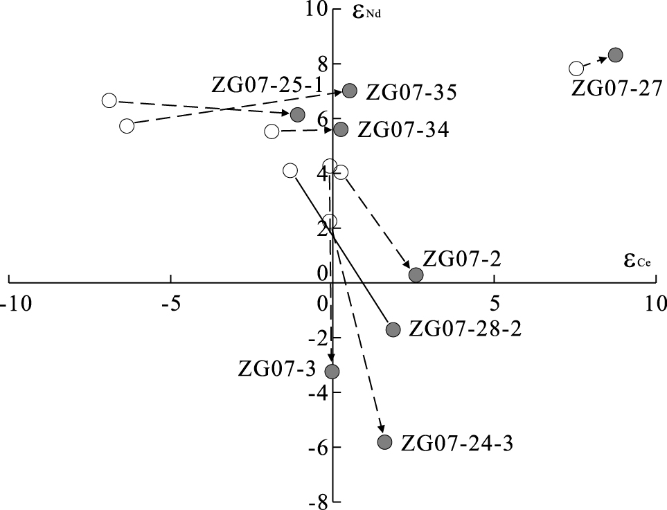
Element Ce shows variable valences in the nature, which accounts for the decoupling between La-Ce and Sm-Nd isotopic system. In addition to a radiometric application, the La-Ce system thus sheds new light on a set of studies such as crust recycling in mantle components, oxidation events during outer sphere evolution of the Earth and metallogenesis. This paper consists of two parts. The first part summarizes the application status of the La-Ce system, its analytical problem faced as well as developing trends in experimental technique and geological application. The second half describes a new chemical procedure for La-Ce separation and purification. Analytical results for some USGS standards and some gabbroic rocks from the Neoproterozoic Huangling complex, interior of the Yangtze craton, are also reported.
Element Ce shows variable valences in the nature, which accounts for the decoupling between La-Ce and Sm-Nd isotopic system. In addition to a radiometric application, the La-Ce system thus sheds new light on a set of studies such as crust recycling in mantle components, oxidation events during outer sphere evolution of the Earth and metallogenesis. This paper consists of two parts. The first part summarizes the application status of the La-Ce system, its analytical problem faced as well as developing trends in experimental technique and geological application. The second half describes a new chemical procedure for La-Ce separation and purification. Analytical results for some USGS standards and some gabbroic rocks from the Neoproterozoic Huangling complex, interior of the Yangtze craton, are also reported.
2011, 36(1): 43-52.
doi: 10.3799/dqkx.2011.005
Abstract:
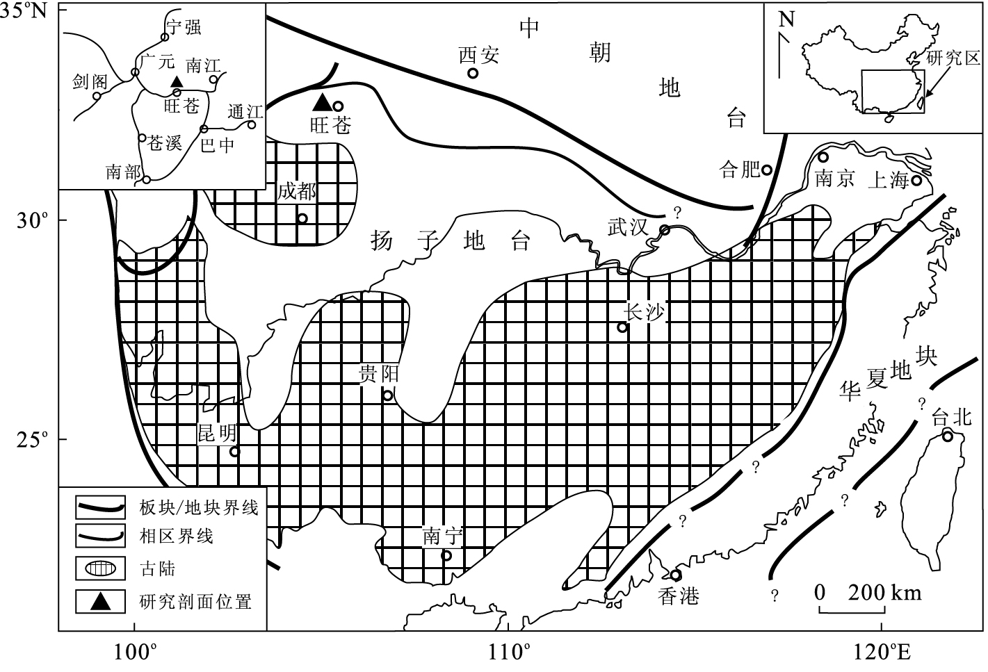
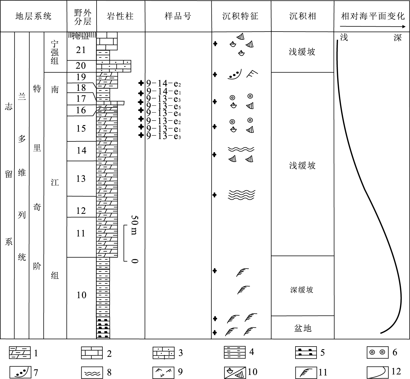
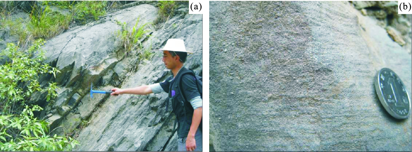
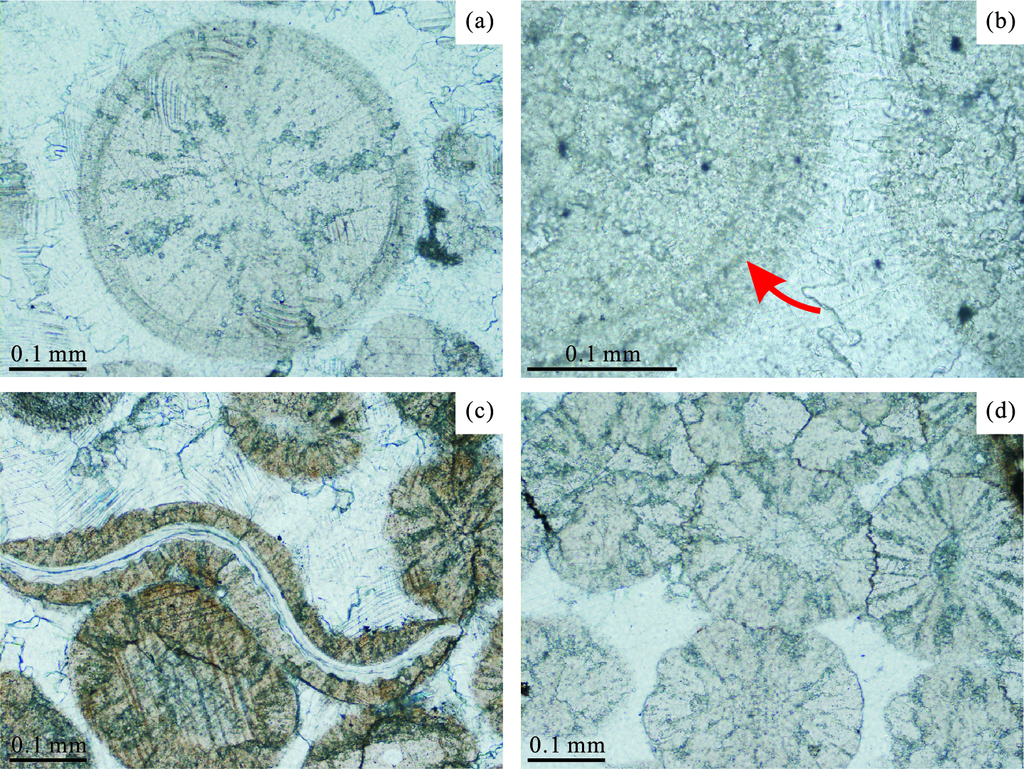
Oolitic limestone has been recognized for the first time in the Early Silurian (Telychian) Nanjiang Formation from Wangcang, NW Sichuan. Facies analyses show that this oolitic-bearing succession developed in a ramp environment. With the thickness less than 10 cm in general and interbedded in the ramp succession, it can be determined that the oolitic layers were moved by episodic currents probably from a large oolitic beach near Wangcang, NW Sichuan, Upper Yangtze platform. Under the microscope, the categories of the oolites are monotonous, and somewhat compressed and deformed, with close contacts and serrated appearances. It also indicates that the oolites should be well-sorted and transported under the high-energy environment, and then be compacted during the following diagenetic stage. The oxygen and carbon isotope analyses of the oolites indicate that the paleotemperature is 25-31 ℃, suggesting tropical to subtropical climates of the mediate to low latitude during the Early Silurian (Telychian) in the Upper Yangtze region. Besides the study of the paleoclimate and paleogeography, as the high-quality reservoir rock, the discovery of the Early Silurian oolitic beds and the possible related oolitic beach nearby is helpful for the oil-gas exploration in NW Sichuan.
Oolitic limestone has been recognized for the first time in the Early Silurian (Telychian) Nanjiang Formation from Wangcang, NW Sichuan. Facies analyses show that this oolitic-bearing succession developed in a ramp environment. With the thickness less than 10 cm in general and interbedded in the ramp succession, it can be determined that the oolitic layers were moved by episodic currents probably from a large oolitic beach near Wangcang, NW Sichuan, Upper Yangtze platform. Under the microscope, the categories of the oolites are monotonous, and somewhat compressed and deformed, with close contacts and serrated appearances. It also indicates that the oolites should be well-sorted and transported under the high-energy environment, and then be compacted during the following diagenetic stage. The oxygen and carbon isotope analyses of the oolites indicate that the paleotemperature is 25-31 ℃, suggesting tropical to subtropical climates of the mediate to low latitude during the Early Silurian (Telychian) in the Upper Yangtze region. Besides the study of the paleoclimate and paleogeography, as the high-quality reservoir rock, the discovery of the Early Silurian oolitic beds and the possible related oolitic beach nearby is helpful for the oil-gas exploration in NW Sichuan.
Composition and Genesis of n-Alkanes and Their Hydrogen Isotope in Sediments from Saline Lake, China
2011, 36(1): 53-61.
doi: 10.3799/dqkx.2011.006
Abstract:
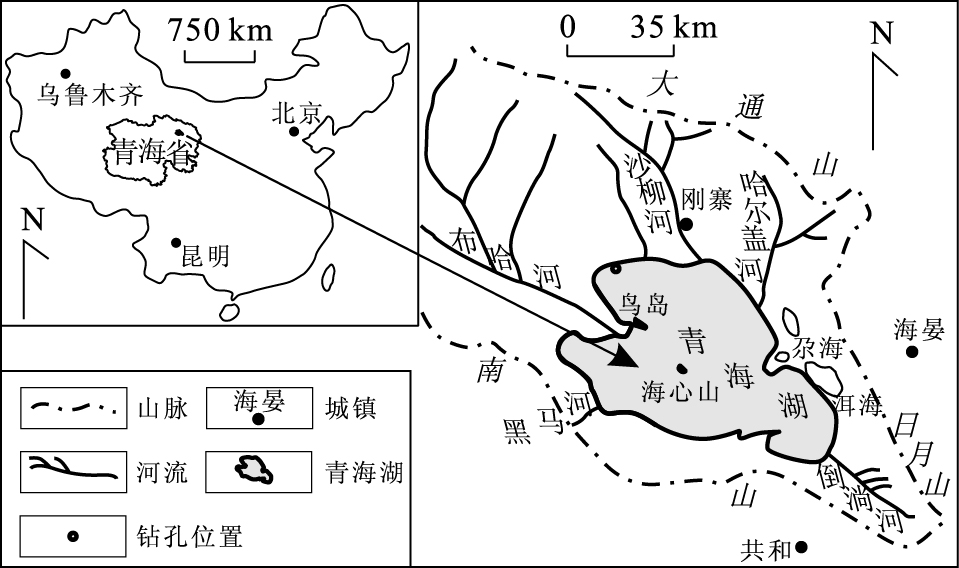
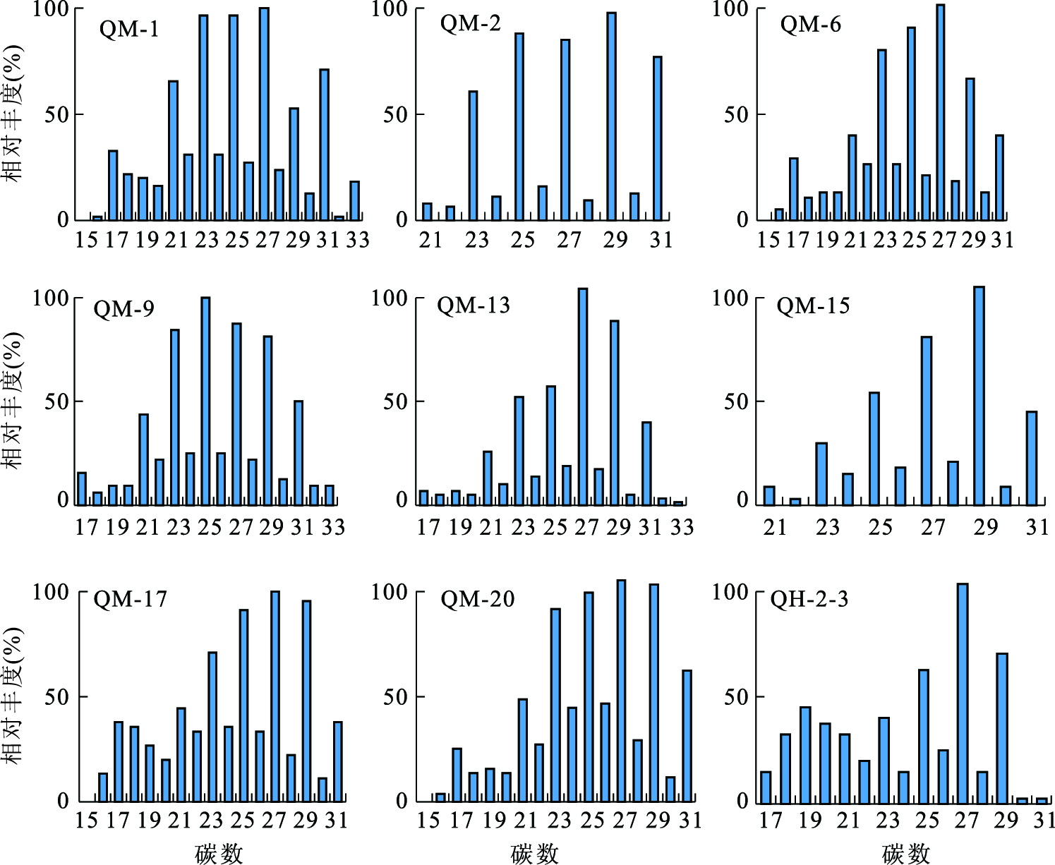
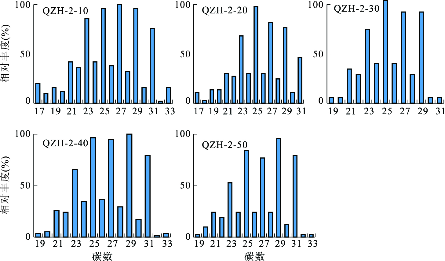
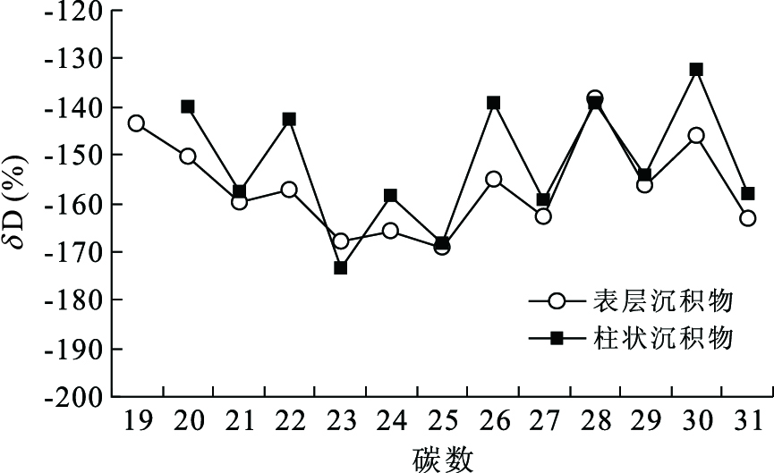
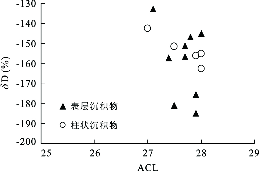
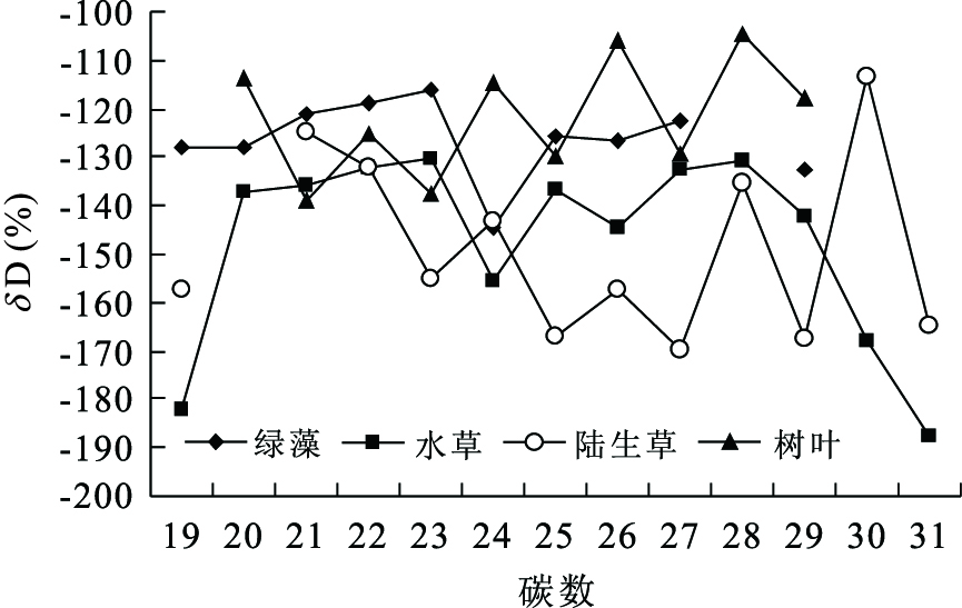
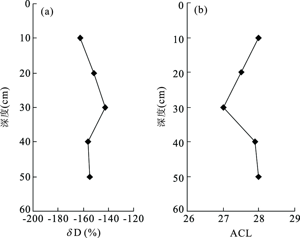
The Qinghai Lake is the largest saline lake in China. We study the compositions of n-alkanes and their hydrogen isotope in sediments from the lake, and discuss the genesis of their compositions by the comparison with previous study results of plants from the lake and its surrounding areas. Our results show that the n-alkanes in the surface and core sediments have a similar distribution which reflects the source from terrestrial herbaceous plants in the surrounding regions of the lake. The hydrogen isotopic compositions of n-alkanes in the surface and core sediments are also similar, which indicates that n-alkanes in the sediments were derived from terrestrial herbaceous plants in surrounding regions of the lake. This study further demonstrates that the hydrogen isotopic compositions of n-alkanes in lake sediment reflect the biological source hydrogen isotopic signals that are related to paleoclimate. Therefore, δD values of n-alkanes in lake sediment can be used to indicate paleoclimate.
The Qinghai Lake is the largest saline lake in China. We study the compositions of n-alkanes and their hydrogen isotope in sediments from the lake, and discuss the genesis of their compositions by the comparison with previous study results of plants from the lake and its surrounding areas. Our results show that the n-alkanes in the surface and core sediments have a similar distribution which reflects the source from terrestrial herbaceous plants in the surrounding regions of the lake. The hydrogen isotopic compositions of n-alkanes in the surface and core sediments are also similar, which indicates that n-alkanes in the sediments were derived from terrestrial herbaceous plants in surrounding regions of the lake. This study further demonstrates that the hydrogen isotopic compositions of n-alkanes in lake sediment reflect the biological source hydrogen isotopic signals that are related to paleoclimate. Therefore, δD values of n-alkanes in lake sediment can be used to indicate paleoclimate.
2011, 36(1): 62-72.
doi: 10.3799/dqkx.2011.007
Abstract:
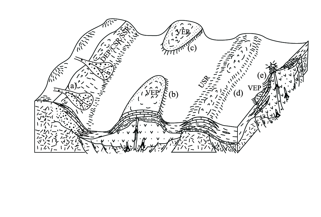
A study of depositional characteristics on carbonate rocks of Permo-Carboniferous was carried out by analyzing of petrology and their formation characteristics of carbonate rocks. A lot of fieldworks of the Permo-Carboniferous system in the study area indicate that, the carbonate rocks of Permo-Carboniferous are dominated by calcirudite, crinoidal limestone and micrite with massive structure and graded bedding, volcanic or pyroclastic rocks acting as pedestals and interbeds of the carbonate formations prevail in the area, which show the neritic paleoenvironmental settings of frequent tension-faulting, strong volcanism, steep topography and deeper water during the period of Permo-Carboniferous. The Permo-Carboniferous carbonate rock formations respectively on the pedestals of volcanic or pyroclastic rocks, granulites from braided river or fan deltas, mudstones originated from littoral zone and shelf comprise volcano-elevated carbonate rock formation (VEF), delta-elevated carbonate rock formation (DEF), coast-subsiding carbonate rock formation (CSF) and shelf-shoaling carbonate rock formation (SSF).The formations, all of which were formed by working together of region tectonics and change in sea level, show the distinct mechanism of construction. Among of them, the volcano-elevated formation, with volcanic or pyroclastic interbeds and prevailling in the area, originated from the relative sea level fall driven by volcano eruption resulting from tectonic extension, in the setting of long-term rise in sea level. The delta-elevated formation inferior to the volcano-elevated in development, with granulite interbeds, arose from the relative sea level fall driven by braided river or fan deltas progradation resulting from tectonic uplifting, in the context of long-term rise in sea level. The coast-subsiding and shelf-shoaling formations, subordinate to the former two, came from short-term sea level fall under the circumstances of regional steady tectonics. However, the depositional characteristics of the carbonate rock formations having the differences in lithology, depositional texture, depositional structure and paleo-fauna assemblage, are constrained by depositional environment. Besides, four kinds of deposition models for the four carbonate rock formations above, i.e. volcano-elevated carbonate platform (VEP), delta-elevated carbonate platform (DEP), coast/uplift-subsiding carbonate ramp (CSR) and shelf-shoaling carbonate ramp (SSR), are produced with distinct depositional characteristics respectively. The neritic shelf paleoenvironment of the age is favorable to development of the marine-originated source rocks. As a result of this, the carbonate rocks, the volcanic rocks, pyroclastic rocks, and the granulites of pedestals and interbeds, originated from braided river and fan deltas become the potential reservoirs of Permo-Carboniferous for oil and gas in the area.
A study of depositional characteristics on carbonate rocks of Permo-Carboniferous was carried out by analyzing of petrology and their formation characteristics of carbonate rocks. A lot of fieldworks of the Permo-Carboniferous system in the study area indicate that, the carbonate rocks of Permo-Carboniferous are dominated by calcirudite, crinoidal limestone and micrite with massive structure and graded bedding, volcanic or pyroclastic rocks acting as pedestals and interbeds of the carbonate formations prevail in the area, which show the neritic paleoenvironmental settings of frequent tension-faulting, strong volcanism, steep topography and deeper water during the period of Permo-Carboniferous. The Permo-Carboniferous carbonate rock formations respectively on the pedestals of volcanic or pyroclastic rocks, granulites from braided river or fan deltas, mudstones originated from littoral zone and shelf comprise volcano-elevated carbonate rock formation (VEF), delta-elevated carbonate rock formation (DEF), coast-subsiding carbonate rock formation (CSF) and shelf-shoaling carbonate rock formation (SSF).The formations, all of which were formed by working together of region tectonics and change in sea level, show the distinct mechanism of construction. Among of them, the volcano-elevated formation, with volcanic or pyroclastic interbeds and prevailling in the area, originated from the relative sea level fall driven by volcano eruption resulting from tectonic extension, in the setting of long-term rise in sea level. The delta-elevated formation inferior to the volcano-elevated in development, with granulite interbeds, arose from the relative sea level fall driven by braided river or fan deltas progradation resulting from tectonic uplifting, in the context of long-term rise in sea level. The coast-subsiding and shelf-shoaling formations, subordinate to the former two, came from short-term sea level fall under the circumstances of regional steady tectonics. However, the depositional characteristics of the carbonate rock formations having the differences in lithology, depositional texture, depositional structure and paleo-fauna assemblage, are constrained by depositional environment. Besides, four kinds of deposition models for the four carbonate rock formations above, i.e. volcano-elevated carbonate platform (VEP), delta-elevated carbonate platform (DEP), coast/uplift-subsiding carbonate ramp (CSR) and shelf-shoaling carbonate ramp (SSR), are produced with distinct depositional characteristics respectively. The neritic shelf paleoenvironment of the age is favorable to development of the marine-originated source rocks. As a result of this, the carbonate rocks, the volcanic rocks, pyroclastic rocks, and the granulites of pedestals and interbeds, originated from braided river and fan deltas become the potential reservoirs of Permo-Carboniferous for oil and gas in the area.


2011, 36(1): 73-82.
doi: 10.3799/dqkx.2011.008
Abstract:
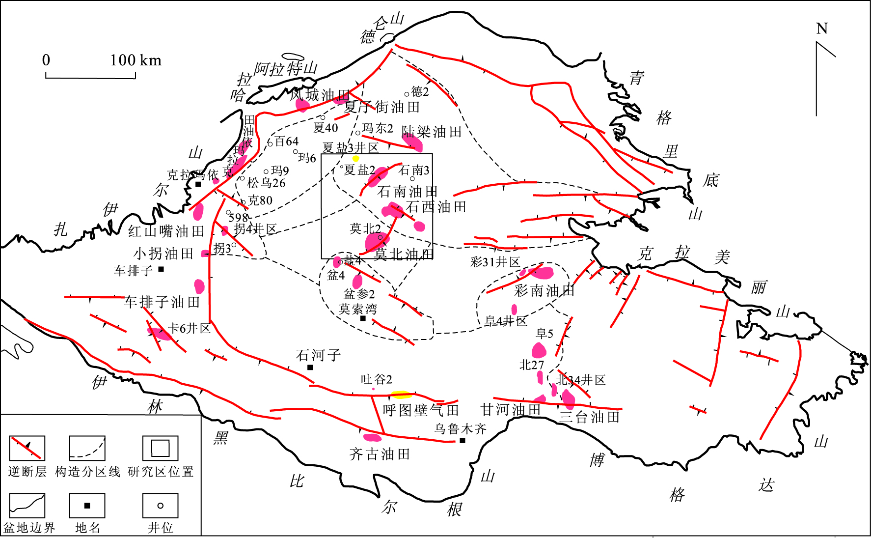
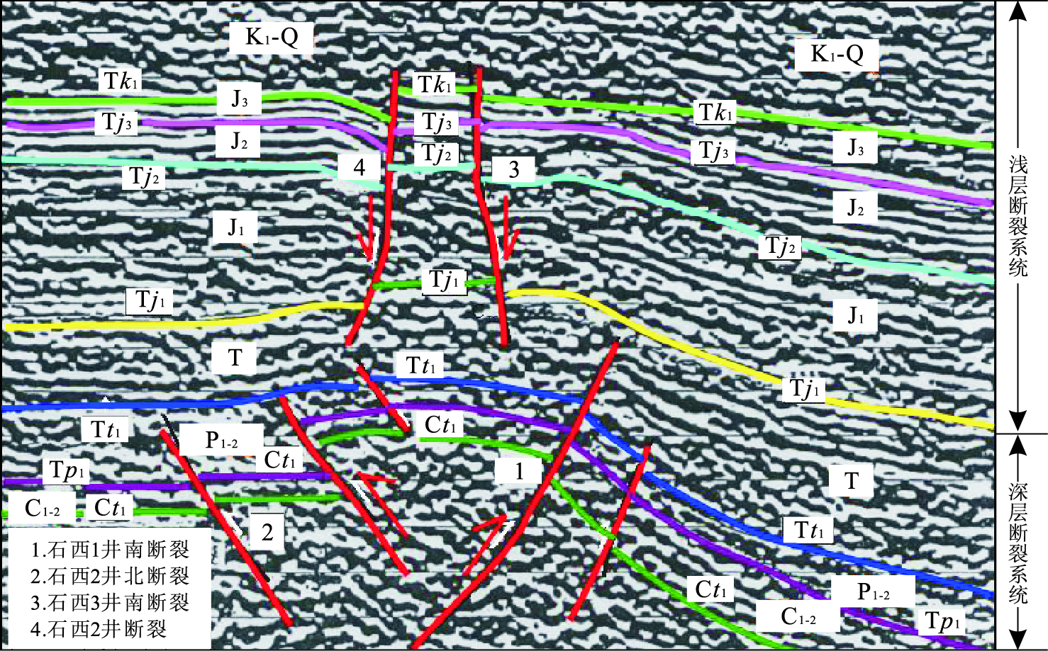
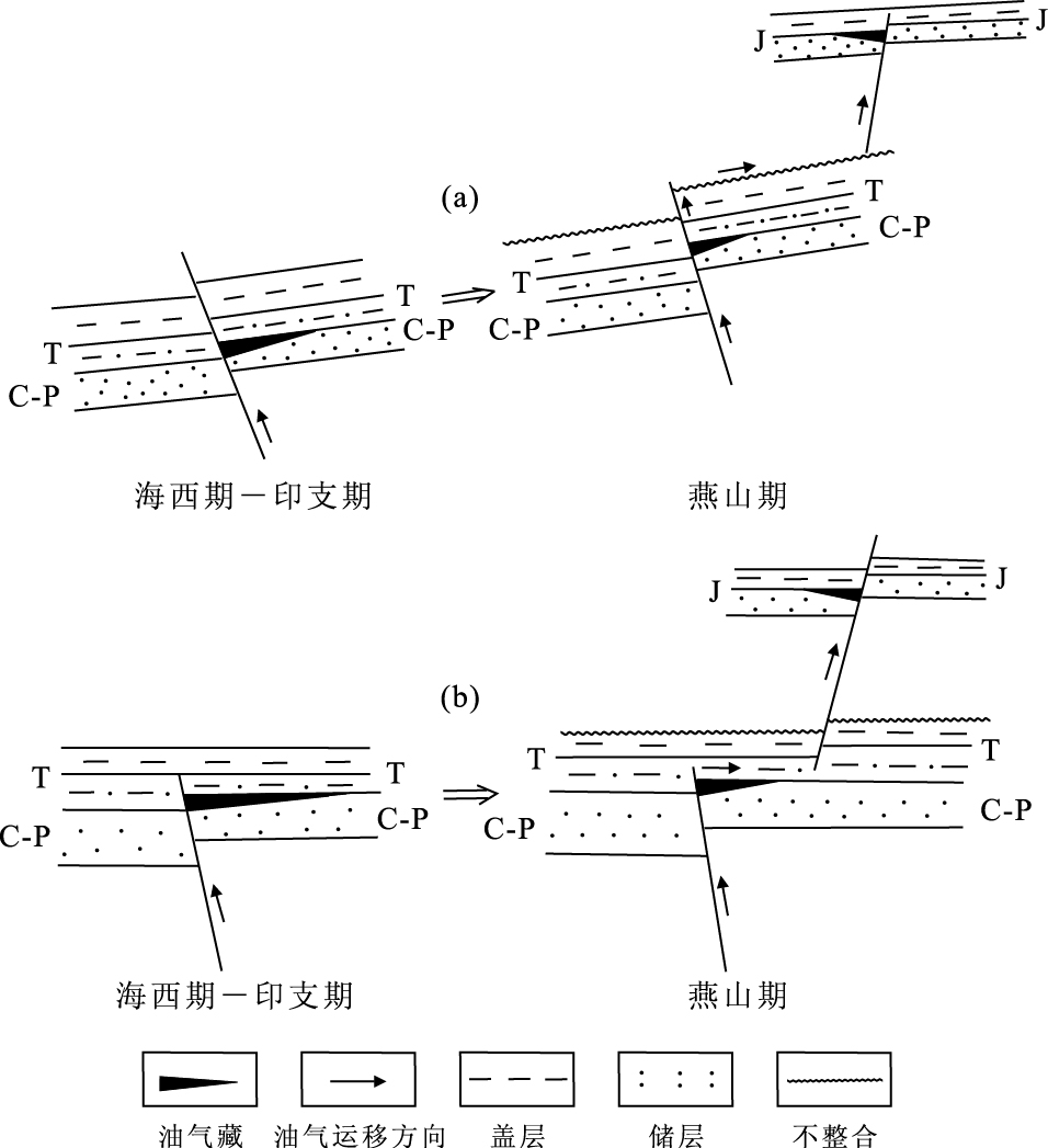
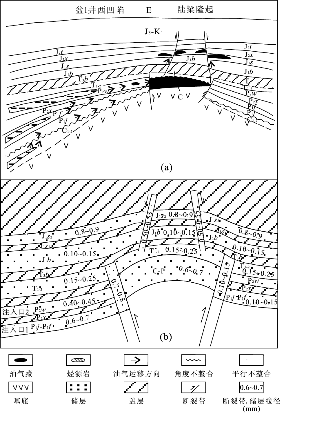
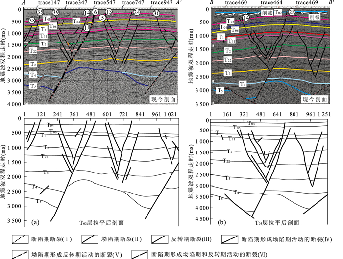
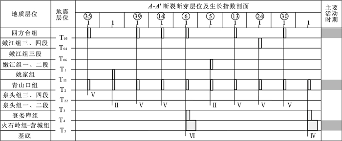
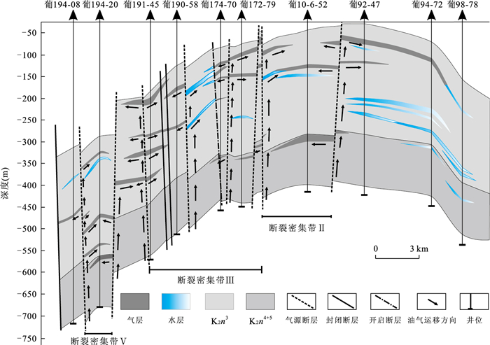
Based on the studies on the faults system in the central part of Junggar basin such as the 2D and 3D seismic faults structural style interpretation, deep and shallow layer fault growth index, fault activity rate calculation, and maximum principle stress test in various tectonic events analyzed from acoustic emission data, as well as study on the regional structural evolution and hydrocarbon migration and accumulation, the faults system formation, evolution, basic characteristics and hydrocarbon-controlling model are studied through experiments, which simulate continuous, stable and single phase hydrocarbon (oil phase) migration and accumulation process, respectively in deep and shallow faults system. Results show that central part of Junggar basin experienced compression and strike-slip resulted from collision by Peripheral plates, leading to well-developed faults. There occur two types of faults system in vertical with different property in the deep and shallow layers. The deep one is basement-involved thrust-type pressure-shear fault system; the shallow one is seal detachment transtension normal fault system, respectively formed in the middle-late Hercynian and early-middle Yanshan. High permeable fault belt is truly hydrocarbon predominant migration pathway. Deep and shallow fault system in the central part of Junggar basin is main pathways for hydrocarbon migration. The permeability of fault belts determines the direction and pathway of hydrocarbon migration. With the seal from the top of fault system, hydrocarbon moves up heterogeneously within the fault, with oil saturation increasing downward. Hydrocarbon tends to migrate within the reservoir with good prosperity under regional seal, and enters prior reservoir with high permeability in the upper wall of fault. With the hydrocarbon saturation within fault and hydrocarbon volume increasing in the upper hand of fault, hydrocarbon flows horizontally and accumulates somewhere, and then goes into lower wall of fault with small amount of oil accumulation, thus almost no oil enters the poor prosperity reservoir. This experiment result proves to be correct by the fluid geochemical analytical data of both sides of the fault, which is significant for understanding the oil migration and accumulation in the fault system in the central part of Junggar basin, and is useful for guiding oil exploration and development.
Based on the studies on the faults system in the central part of Junggar basin such as the 2D and 3D seismic faults structural style interpretation, deep and shallow layer fault growth index, fault activity rate calculation, and maximum principle stress test in various tectonic events analyzed from acoustic emission data, as well as study on the regional structural evolution and hydrocarbon migration and accumulation, the faults system formation, evolution, basic characteristics and hydrocarbon-controlling model are studied through experiments, which simulate continuous, stable and single phase hydrocarbon (oil phase) migration and accumulation process, respectively in deep and shallow faults system. Results show that central part of Junggar basin experienced compression and strike-slip resulted from collision by Peripheral plates, leading to well-developed faults. There occur two types of faults system in vertical with different property in the deep and shallow layers. The deep one is basement-involved thrust-type pressure-shear fault system; the shallow one is seal detachment transtension normal fault system, respectively formed in the middle-late Hercynian and early-middle Yanshan. High permeable fault belt is truly hydrocarbon predominant migration pathway. Deep and shallow fault system in the central part of Junggar basin is main pathways for hydrocarbon migration. The permeability of fault belts determines the direction and pathway of hydrocarbon migration. With the seal from the top of fault system, hydrocarbon moves up heterogeneously within the fault, with oil saturation increasing downward. Hydrocarbon tends to migrate within the reservoir with good prosperity under regional seal, and enters prior reservoir with high permeability in the upper wall of fault. With the hydrocarbon saturation within fault and hydrocarbon volume increasing in the upper hand of fault, hydrocarbon flows horizontally and accumulates somewhere, and then goes into lower wall of fault with small amount of oil accumulation, thus almost no oil enters the poor prosperity reservoir. This experiment result proves to be correct by the fluid geochemical analytical data of both sides of the fault, which is significant for understanding the oil migration and accumulation in the fault system in the central part of Junggar basin, and is useful for guiding oil exploration and development.

2011, 36(1): 83-92.
doi: 10.3799/dqkx.2011.009
Abstract:
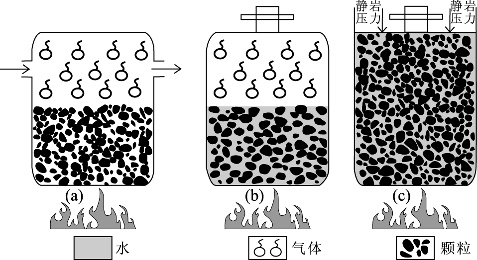
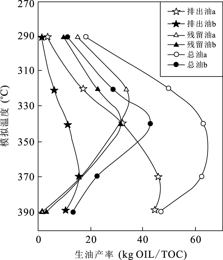
A special simulation experimental device using a high pressure liquid water system in the similar geological pore space with fluid pressures around 38±2 MPa and temperatures ranging from 290 ℃ to 390 ℃ is used to simulate hydrocarbon generation and expulsion from source rocks in this study. The new experimental results show many important phenomena about the generation and expulsion influenced by high-pressure liquid water linking with fluid pressure and pore space. It is found that high-pressure liquid water medium condition facilitates the generation and preservation of liquid oil and improves the potential of hydrocarbon generation from kerogen and the efficiency of oil expulsion but it is not conducive to the conversion of liquid hydrocarbon to gaseous hydrocarbon. It is considered that these new experimental phenomena may be mainly related to the effects of high-pressure liquid water of near-critical properties. It is further inferred that the high-pressure liquid water of near-critical characteristics is involved in the conversion of kerogen to oil and gas reactions, to increase the solubility of the oil and gas in water. Under the appropriate geological conditions, hydrocarbon generation and expulsion from source rocks occur at temperatures ranging from 100 ℃ to 200 ℃ and pressures ranging from 30 MPa to 120 MPa in most cases, suggesting that actual formation pore water could be a compressed state liquid water with near-critical properties at a relatively low temperature and high-pressure environment. This high-pressure liquid water of near-critical characteristics may have important effect on the processes of petroleum generation and expulsion. However, the mechanism and geological significance for petroleum exploration of these phenomena are still not clear. Further studies are necessary for such simulation experiments under high pressure liquid water condition for better understanding of the actual roles of the factors such as the near-critical water medium, fluid pressure and pore space. It is believed that this study may assist to establish the improving models of dynamics of hydrocarbon generation and expulsion in geological scale.
A special simulation experimental device using a high pressure liquid water system in the similar geological pore space with fluid pressures around 38±2 MPa and temperatures ranging from 290 ℃ to 390 ℃ is used to simulate hydrocarbon generation and expulsion from source rocks in this study. The new experimental results show many important phenomena about the generation and expulsion influenced by high-pressure liquid water linking with fluid pressure and pore space. It is found that high-pressure liquid water medium condition facilitates the generation and preservation of liquid oil and improves the potential of hydrocarbon generation from kerogen and the efficiency of oil expulsion but it is not conducive to the conversion of liquid hydrocarbon to gaseous hydrocarbon. It is considered that these new experimental phenomena may be mainly related to the effects of high-pressure liquid water of near-critical properties. It is further inferred that the high-pressure liquid water of near-critical characteristics is involved in the conversion of kerogen to oil and gas reactions, to increase the solubility of the oil and gas in water. Under the appropriate geological conditions, hydrocarbon generation and expulsion from source rocks occur at temperatures ranging from 100 ℃ to 200 ℃ and pressures ranging from 30 MPa to 120 MPa in most cases, suggesting that actual formation pore water could be a compressed state liquid water with near-critical properties at a relatively low temperature and high-pressure environment. This high-pressure liquid water of near-critical characteristics may have important effect on the processes of petroleum generation and expulsion. However, the mechanism and geological significance for petroleum exploration of these phenomena are still not clear. Further studies are necessary for such simulation experiments under high pressure liquid water condition for better understanding of the actual roles of the factors such as the near-critical water medium, fluid pressure and pore space. It is believed that this study may assist to establish the improving models of dynamics of hydrocarbon generation and expulsion in geological scale.
2011, 36(1): 93-102.
doi: 10.3799/dqkx.2011.010
Abstract:
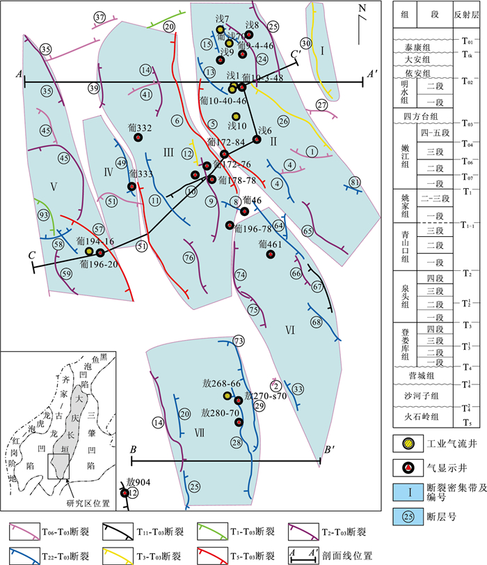
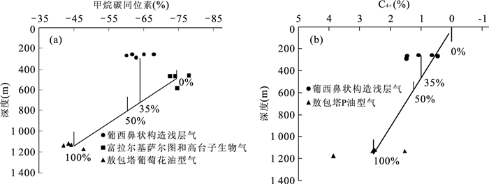
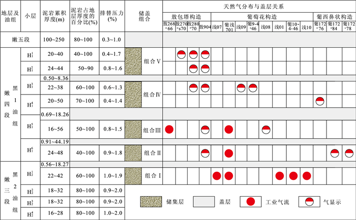
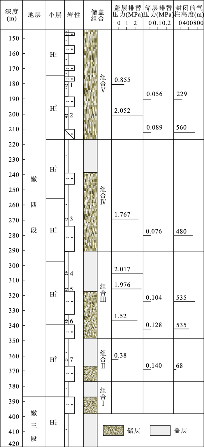
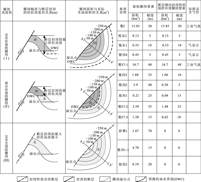
Shallow gas in the south of Daqing placanticline is mainly biogas originated from K1n1+2, mixed with a small amount of thermogenic gas of K1qn and inorganic CO2. The main biogas generation and expulsion period of K1n1+2 is the end of K2m sedimentary period, when fault activities caused the formation of anticline and fault trap of Heidimiao oil layer and induced vertical migration of biogas. The composite of the three periods made large amount of biogas migrate into Heidimiao oil layer. Active faults are all boundary faults in fault-condensed belt, along which biogas migrated vertically. The position of biogas accumulation depends on allocation relation between fault and strata of two walls. The wall whose dip is contrary to that of the fault is the main position for biogas accumulation. Generally the southern part of Daqing placanticline is an asymmetric anticline that is gentle in the west and steep in the east. Biogas is mainly accumulated in the traps of the east boundary of fault-condensed belt. There are 5 sets of reservoir-seal assemblages. Cap rock thicknesses of 3 sets of assemblages in the lower part are greater and the probabilities of them to be leaped by faults are relatively small. They are the main target beds. Most of the traps in Heidimiao oil layer are fault traps. The lateral sealing of fault determines trapping potential. The lower limit of SGR required by lateral seal of fault is 0.375. There are 3 kinds of situations when we analyze trapping potential by use of Allen graphic to calibrate lateral sealing of fault or not taking lateral sealing of fault into consideration. The first is that fault is sealing in the lateral and the area and amplitude of trap don't change (type Ⅰ). The second is that the lateral sealing of fault is sectionalized and the area and amplitude of trap become smaller (type Ⅱ). The third is that fault isn't sealing in the lateral and there is no trap (type Ⅲ). Among them, traps of Ⅰand Ⅱare favorable targets for biogas accumulation. The south of Daqing placanticline shows that the key factors of shallow gas accumulation in Songliao basin are integrity of traps controlled by faults that can connect gas source and regional distributed cap rocks.
Shallow gas in the south of Daqing placanticline is mainly biogas originated from K1n1+2, mixed with a small amount of thermogenic gas of K1qn and inorganic CO2. The main biogas generation and expulsion period of K1n1+2 is the end of K2m sedimentary period, when fault activities caused the formation of anticline and fault trap of Heidimiao oil layer and induced vertical migration of biogas. The composite of the three periods made large amount of biogas migrate into Heidimiao oil layer. Active faults are all boundary faults in fault-condensed belt, along which biogas migrated vertically. The position of biogas accumulation depends on allocation relation between fault and strata of two walls. The wall whose dip is contrary to that of the fault is the main position for biogas accumulation. Generally the southern part of Daqing placanticline is an asymmetric anticline that is gentle in the west and steep in the east. Biogas is mainly accumulated in the traps of the east boundary of fault-condensed belt. There are 5 sets of reservoir-seal assemblages. Cap rock thicknesses of 3 sets of assemblages in the lower part are greater and the probabilities of them to be leaped by faults are relatively small. They are the main target beds. Most of the traps in Heidimiao oil layer are fault traps. The lateral sealing of fault determines trapping potential. The lower limit of SGR required by lateral seal of fault is 0.375. There are 3 kinds of situations when we analyze trapping potential by use of Allen graphic to calibrate lateral sealing of fault or not taking lateral sealing of fault into consideration. The first is that fault is sealing in the lateral and the area and amplitude of trap don't change (type Ⅰ). The second is that the lateral sealing of fault is sectionalized and the area and amplitude of trap become smaller (type Ⅱ). The third is that fault isn't sealing in the lateral and there is no trap (type Ⅲ). Among them, traps of Ⅰand Ⅱare favorable targets for biogas accumulation. The south of Daqing placanticline shows that the key factors of shallow gas accumulation in Songliao basin are integrity of traps controlled by faults that can connect gas source and regional distributed cap rocks.
2011, 36(1): 103-110.
doi: 10.3799/dqkx.2011.011
Abstract:
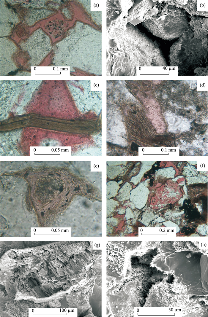
In order to figure out the relationship between reservoir porosity and iron-rich chlorite cementation, the pore characteristic, rock constituents and relationship between pore and rock constituents of sandstone were studied by using cast thin sections, scanning electron microscope and electron microprobe techniques. The study reveals that the pore-line chlorite offers limited protection to the porosity, and the greatest contribution to the porosity is alkaline dissolution of volcanic materials. The volcanic materials (matrix and grain) belong to medium-basic volcanics through quantitative calculation of iron content in the chlorite cementation. During the early diagenetic stage, A 7%-11% medium-basic volcanics were dissolved, and this alkaine dissolution process yielded 8% secondary porosity and 3% pore-lining chlorite. The widespread chlorite cementation just indicates that abundant medium-basic volcanics were dissolved and considerable alkaline dissolution pore was generated.
In order to figure out the relationship between reservoir porosity and iron-rich chlorite cementation, the pore characteristic, rock constituents and relationship between pore and rock constituents of sandstone were studied by using cast thin sections, scanning electron microscope and electron microprobe techniques. The study reveals that the pore-line chlorite offers limited protection to the porosity, and the greatest contribution to the porosity is alkaline dissolution of volcanic materials. The volcanic materials (matrix and grain) belong to medium-basic volcanics through quantitative calculation of iron content in the chlorite cementation. During the early diagenetic stage, A 7%-11% medium-basic volcanics were dissolved, and this alkaine dissolution process yielded 8% secondary porosity and 3% pore-lining chlorite. The widespread chlorite cementation just indicates that abundant medium-basic volcanics were dissolved and considerable alkaline dissolution pore was generated.

2011, 36(1): 111-121.
doi: 10.3799/dqkx.2011.012
Abstract:
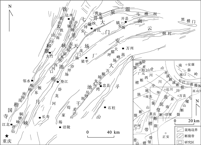
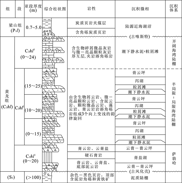
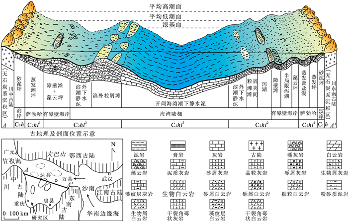
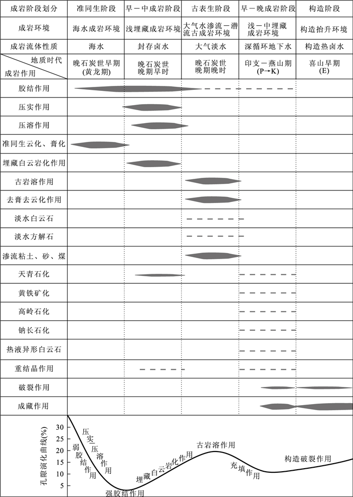
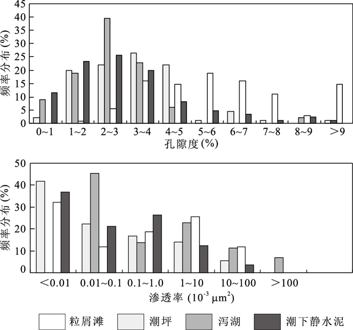
The Huanglong Formation of Upper Carboniferous in eastern Sichuan basin, is the principal producing formation of natural gas pool. Based on the observation of cores, actual measurement of outdoors sections and analysis of thin section, and the data of well drilling, well logging, physical property analysis and X-diffraction analysis, we have studied the sedimentary-diagenetic system of carbonatite reservoirs in the Huanglong Formation, eastern Sichuan basin. It is believed that the Huanglong Formation mainly developed three facies belts, including sabkha, barrier coast and continental shelf, and particular palaeokarst facies. The types of reservoir rocks are mainly grain dolomite and dolomitic-karst breccia. The effective reservoir interspaces are mainly intercrystal pore and dissolved pore. The most important types of reservoir is cavity-seam. The beneficial localization for the development of reservoirs is the microtopography unit of hillsides and residual hills on sur-slope of palaeokarst. According to the studies above-mentioned, it is proposed that the sedimentary-diagenetic system has a good coupling relationship with reservoirs on time and space. The particles shoal of sedimentary microfacies controls the distribution of location regional of reservoirs. The diagenetic system of compaction-bittern of early-middle diagenetic stage, the diagenetic system of atmospheric water of paleo-hypergene stage and the diagenetic system of thermobaric-water of burial diagenetic stage contribute much to the development of goodness reservoirs.
The Huanglong Formation of Upper Carboniferous in eastern Sichuan basin, is the principal producing formation of natural gas pool. Based on the observation of cores, actual measurement of outdoors sections and analysis of thin section, and the data of well drilling, well logging, physical property analysis and X-diffraction analysis, we have studied the sedimentary-diagenetic system of carbonatite reservoirs in the Huanglong Formation, eastern Sichuan basin. It is believed that the Huanglong Formation mainly developed three facies belts, including sabkha, barrier coast and continental shelf, and particular palaeokarst facies. The types of reservoir rocks are mainly grain dolomite and dolomitic-karst breccia. The effective reservoir interspaces are mainly intercrystal pore and dissolved pore. The most important types of reservoir is cavity-seam. The beneficial localization for the development of reservoirs is the microtopography unit of hillsides and residual hills on sur-slope of palaeokarst. According to the studies above-mentioned, it is proposed that the sedimentary-diagenetic system has a good coupling relationship with reservoirs on time and space. The particles shoal of sedimentary microfacies controls the distribution of location regional of reservoirs. The diagenetic system of compaction-bittern of early-middle diagenetic stage, the diagenetic system of atmospheric water of paleo-hypergene stage and the diagenetic system of thermobaric-water of burial diagenetic stage contribute much to the development of goodness reservoirs.
2011, 36(1): 122-130.
doi: 10.3799/dqkx.2011.013
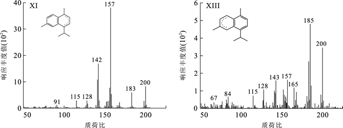
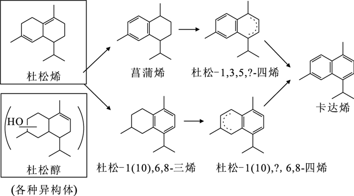
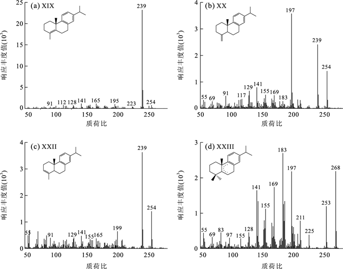
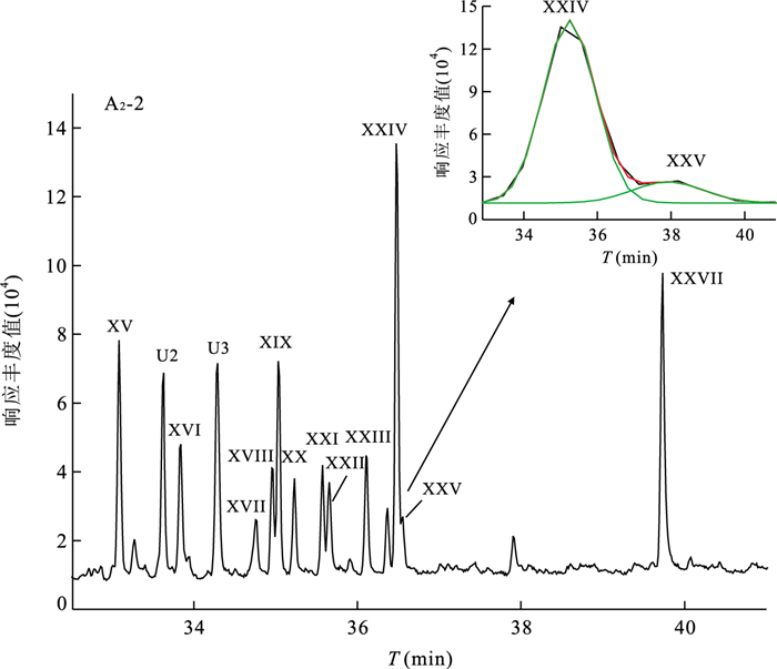
Abstract:
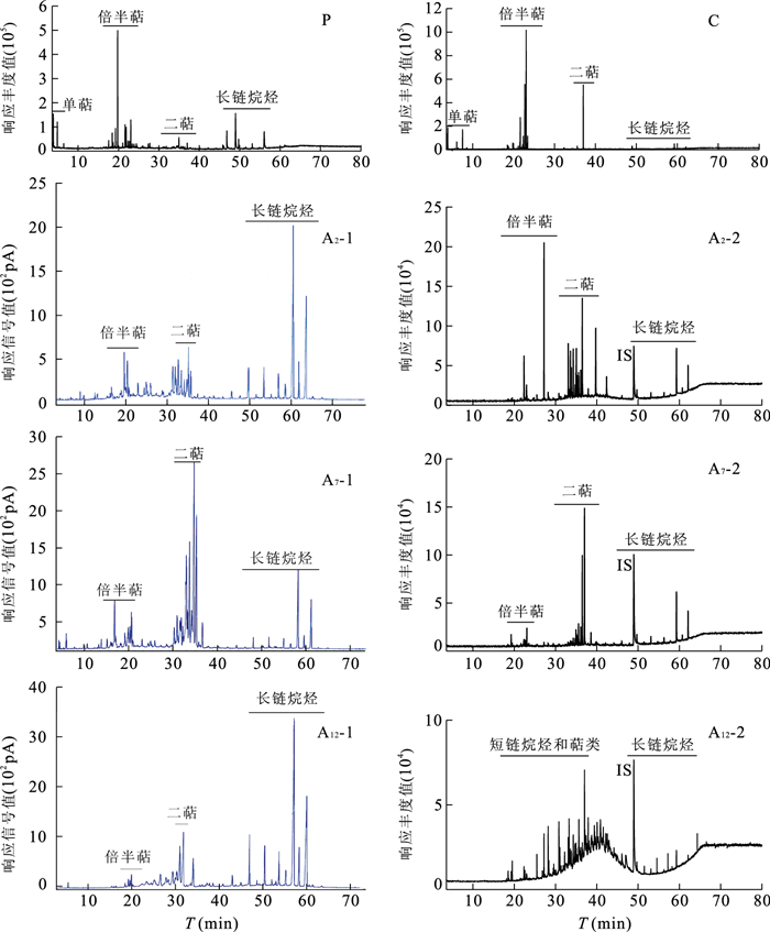
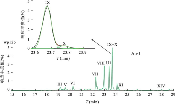
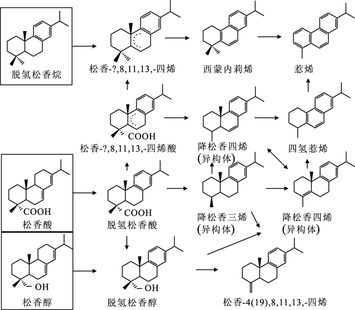
Conifer samples were simulated for more than five years at low temperature (80 ℃) in order to study their early alteration processes. The samples were analyzed by chromatography and gas chromatography-mass spectrometry when the simulation lasted approximately one year and five and a half years, respectively. The results show that the alkanes and terpenoids of coniferous organic matter can undergo a remarkable and rapid alteration after sedimentation. Some seldom reported evolutionary intermediates of terpenoids, i.e. two cadinatetraenes, one abietatetraene and three norabietatetraenes, were identified based on their mass fragments. Then the early evolutionary pathways of cadalane-type sesquiterpenoids and abietane-type diterpenoids were proposed. In these processes, the dehydrogenated and aromatic terpenoids are main evolutionary products, which may be mediated by undefined bacteria.
Conifer samples were simulated for more than five years at low temperature (80 ℃) in order to study their early alteration processes. The samples were analyzed by chromatography and gas chromatography-mass spectrometry when the simulation lasted approximately one year and five and a half years, respectively. The results show that the alkanes and terpenoids of coniferous organic matter can undergo a remarkable and rapid alteration after sedimentation. Some seldom reported evolutionary intermediates of terpenoids, i.e. two cadinatetraenes, one abietatetraene and three norabietatetraenes, were identified based on their mass fragments. Then the early evolutionary pathways of cadalane-type sesquiterpenoids and abietane-type diterpenoids were proposed. In these processes, the dehydrogenated and aromatic terpenoids are main evolutionary products, which may be mediated by undefined bacteria.
2011, 36(1): 131-138.
doi: 10.3799/dqkx.2011.014
Abstract:
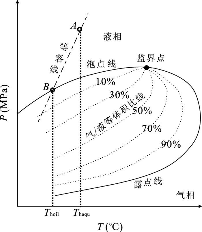
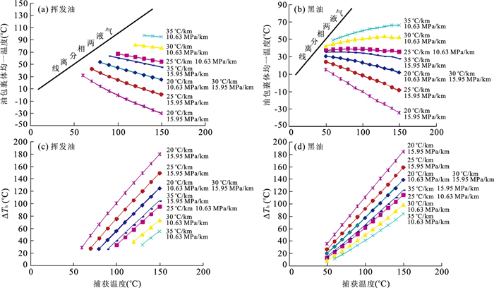
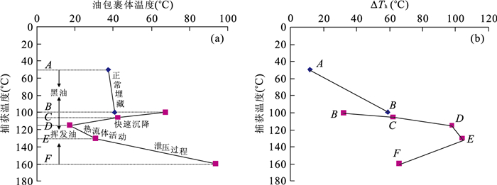
Petroleum inclusions trapped in diagenetic minerals have been extensively applied to studies of constraint hydrocarbon migration and accumulation, but the effects on petroleum inclusion homogenization temperatures and their geological implications have not been completely understood. In this paper, a thermodynamic modeling method was employed, and two types of black oil and volatile oil were used to simulate their homogenization temperatures and to establish the homogenization temperature relationship between petroleum inclusions and their coeval aqueous inclusions under different P-T conditions. It is concluded that all the petroleum composition, trapped temperature and pressure have influence on the petroleum inclusion homogenization temperature. In contrast, if the trapped P-T and petroleum composition of single inclusion are known, the petroleum inclusion homogenization temperature and the difference between petroleum inclusions and their coeval aqueous inclusions can give geological meanings, which can play a great role on hydrocarbon charging episodes and paleofluid pressure modeling.
Petroleum inclusions trapped in diagenetic minerals have been extensively applied to studies of constraint hydrocarbon migration and accumulation, but the effects on petroleum inclusion homogenization temperatures and their geological implications have not been completely understood. In this paper, a thermodynamic modeling method was employed, and two types of black oil and volatile oil were used to simulate their homogenization temperatures and to establish the homogenization temperature relationship between petroleum inclusions and their coeval aqueous inclusions under different P-T conditions. It is concluded that all the petroleum composition, trapped temperature and pressure have influence on the petroleum inclusion homogenization temperature. In contrast, if the trapped P-T and petroleum composition of single inclusion are known, the petroleum inclusion homogenization temperature and the difference between petroleum inclusions and their coeval aqueous inclusions can give geological meanings, which can play a great role on hydrocarbon charging episodes and paleofluid pressure modeling.

2011, 36(1): 139-150.
doi: 10.3799/dqkx.2011.015
Abstract:
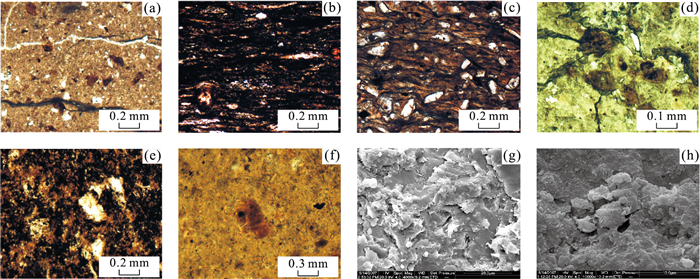
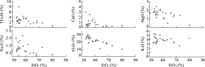
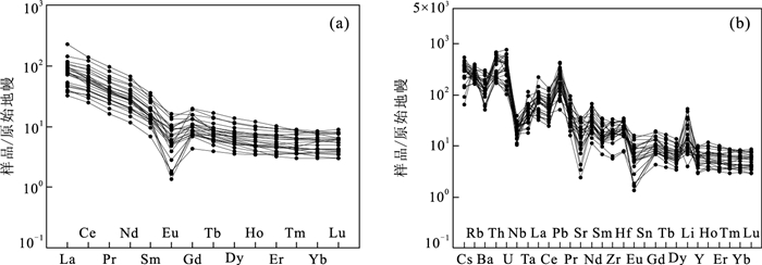
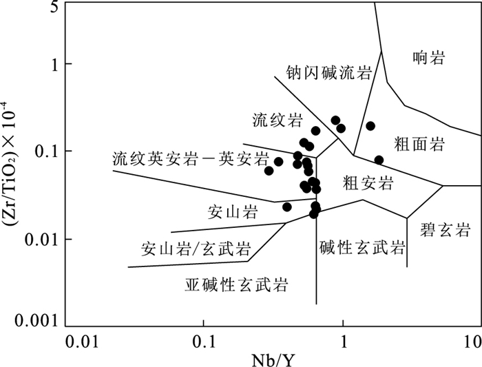
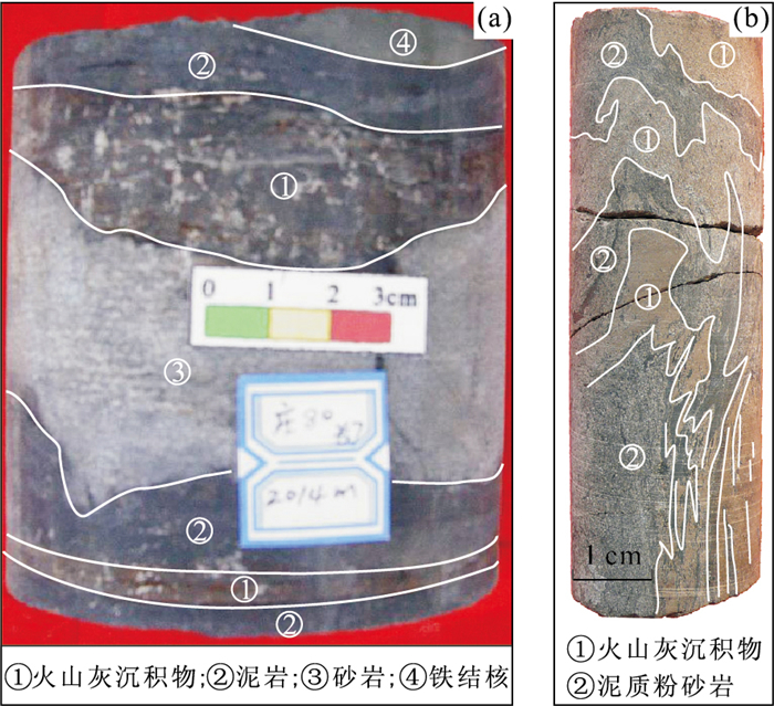
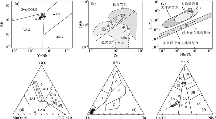
Volcanic ash sediment is widely distributed in Yanchang Formation in Ordos basin, in order to study lithogeochemistry characteristics and formational mechanism of volcanic ashes sediment, the paper use many analysis methods, such as observe the cores, microscope, XRF, ICP-MS, SEM et al.. The results indicate volcanic ash sediment containing much crystal and shard fragments, including tuff and bentonite, the illite and andreattite can be seen under the SEM; SiO2 content between 50.29%-79.82%, rich potassium, K2O+Na2O at 3.20%-7.88%, the negative correlation present in relationship of SiO2 with Al2O3, TFe2O3 and MgO; ∑REE=99.82×10⁻⁶~550.15×10⁻⁶, and rich in LREE, deplete in HREE, the curve rightward incline, Eu negative abnormity and the δEu between 0.147-0.837, there is no evidently Ce abnormity, and K, Rb, Ba, Th are of positive abnormity. In the illustration of Nb/Y-Zr/TiO2, the data dots are mainly located at the zone of andesite-rhyolite, which suggest that the volcanic ash is primary from middle-acid rocks. Lithogeochemistry and sedimentology illustrate the formational mechanisms of volcanic ash include: falling down from air and carried by water. Through the diagram of tectonic setting, the volcanic ash is primary from volcanic arc and calc-alkalic lavas, which is intimately related the evolution of Qinling orogenic belt.
Volcanic ash sediment is widely distributed in Yanchang Formation in Ordos basin, in order to study lithogeochemistry characteristics and formational mechanism of volcanic ashes sediment, the paper use many analysis methods, such as observe the cores, microscope, XRF, ICP-MS, SEM et al.. The results indicate volcanic ash sediment containing much crystal and shard fragments, including tuff and bentonite, the illite and andreattite can be seen under the SEM; SiO2 content between 50.29%-79.82%, rich potassium, K2O+Na2O at 3.20%-7.88%, the negative correlation present in relationship of SiO2 with Al2O3, TFe2O3 and MgO; ∑REE=99.82×10⁻⁶~550.15×10⁻⁶, and rich in LREE, deplete in HREE, the curve rightward incline, Eu negative abnormity and the δEu between 0.147-0.837, there is no evidently Ce abnormity, and K, Rb, Ba, Th are of positive abnormity. In the illustration of Nb/Y-Zr/TiO2, the data dots are mainly located at the zone of andesite-rhyolite, which suggest that the volcanic ash is primary from middle-acid rocks. Lithogeochemistry and sedimentology illustrate the formational mechanisms of volcanic ash include: falling down from air and carried by water. Through the diagram of tectonic setting, the volcanic ash is primary from volcanic arc and calc-alkalic lavas, which is intimately related the evolution of Qinling orogenic belt.

2011, 36(1): 151-162.
doi: 10.3799/dqkx.2011.016
Abstract:
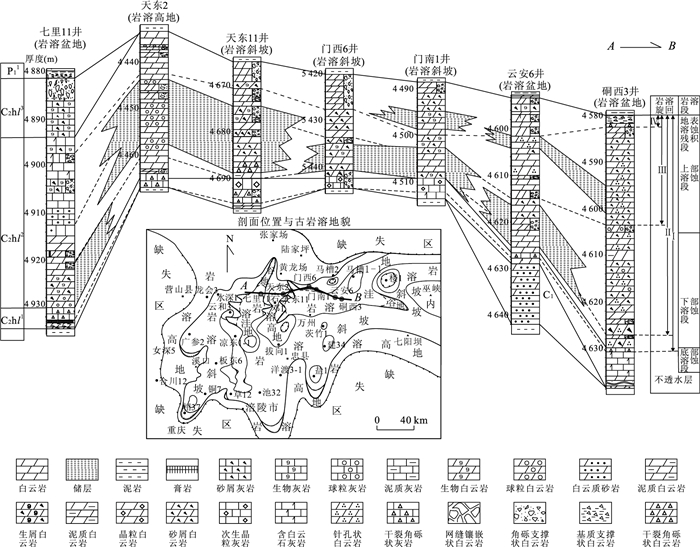
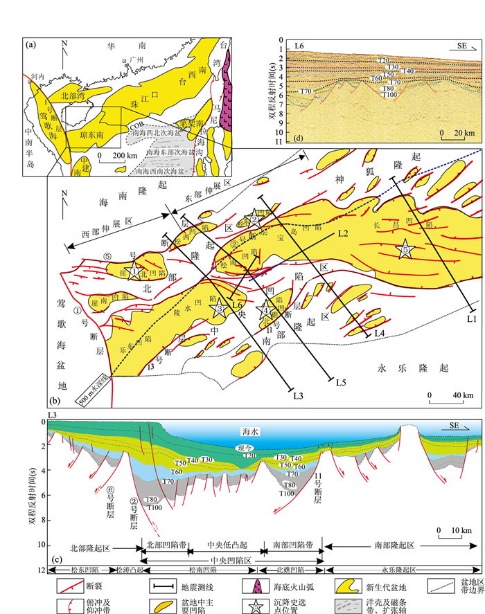
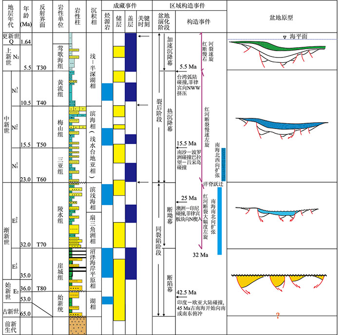
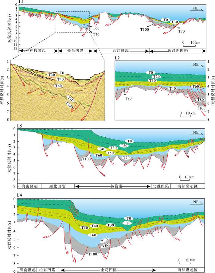
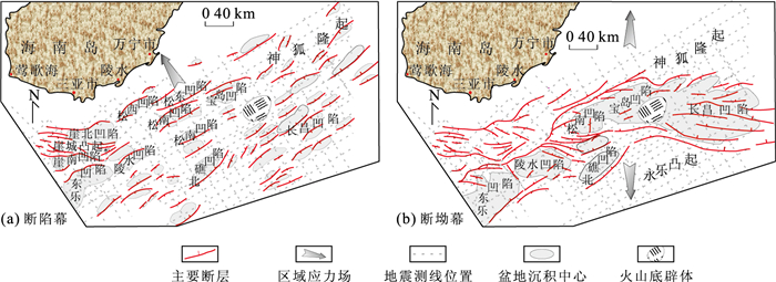
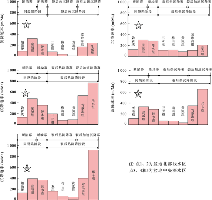
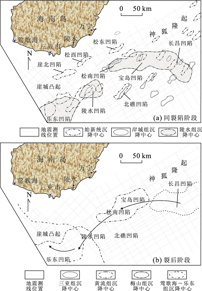
Based on geological structural interpretation of a number of available high-resolution geological-geophysical and drilling data etc., a tectonic framework with zonal array in N-S direction and block division in W-E direction was established in deepwater area of Qiongdongnan basin (QDNB). A key tectonic revolutionary boundary, T70, was identified in QDNB by integrated analysis of tectono-stratigraphy, subsidence history and subsided depocentre migration. A series of small distributed NE-trending faulted basins developed widely below this boundary, while basin depocentre of QDNB above T70 boundary is located in center depression area trending NE-WE-NWW, forming a great fault-sag type basin, which is superimposed clearly over underlying faulted basin group above. Analyses of genetic type and geometry of basin-boundary fault indicate that NW-SE extensional tectonic stress field strongly controlled development of small distributed NE-trending faulted basin group underlying T70 boundary, and nearly SN extensional tectonic stress field resulted in formation of fault-sag basin over this boundary. The T70 boundary can be found and traced in northern continental margin basins of South China Sea. The evidence of regional and biostratigraphical correlation shows that the age of this boundary is 32 Ma, which is consistent with the time of initial spreading of South China Sea. Thus T70 boundary is a regional tectonic revolutionary boundary. The development of this boundary leads to complexity of tectonic framework and structure evolution. According to the T70 boundary, combining with other important boundaries identified in previous literatures in the basin filling sequence and subsidence analysis, four tectonic evolution episodes of QDNB, which are syn-rifted episode, fault-sag episode, post-rifted thermal subsidence episode and post-rifted accelerating subsiding episode, are proposed in this paper. Finally, Cenozoic lithospheric dynamic, kinematical reorganization of plates circum-South China Sea controlling on these tectonic episodes are discussed in depth.
Based on geological structural interpretation of a number of available high-resolution geological-geophysical and drilling data etc., a tectonic framework with zonal array in N-S direction and block division in W-E direction was established in deepwater area of Qiongdongnan basin (QDNB). A key tectonic revolutionary boundary, T70, was identified in QDNB by integrated analysis of tectono-stratigraphy, subsidence history and subsided depocentre migration. A series of small distributed NE-trending faulted basins developed widely below this boundary, while basin depocentre of QDNB above T70 boundary is located in center depression area trending NE-WE-NWW, forming a great fault-sag type basin, which is superimposed clearly over underlying faulted basin group above. Analyses of genetic type and geometry of basin-boundary fault indicate that NW-SE extensional tectonic stress field strongly controlled development of small distributed NE-trending faulted basin group underlying T70 boundary, and nearly SN extensional tectonic stress field resulted in formation of fault-sag basin over this boundary. The T70 boundary can be found and traced in northern continental margin basins of South China Sea. The evidence of regional and biostratigraphical correlation shows that the age of this boundary is 32 Ma, which is consistent with the time of initial spreading of South China Sea. Thus T70 boundary is a regional tectonic revolutionary boundary. The development of this boundary leads to complexity of tectonic framework and structure evolution. According to the T70 boundary, combining with other important boundaries identified in previous literatures in the basin filling sequence and subsidence analysis, four tectonic evolution episodes of QDNB, which are syn-rifted episode, fault-sag episode, post-rifted thermal subsidence episode and post-rifted accelerating subsiding episode, are proposed in this paper. Finally, Cenozoic lithospheric dynamic, kinematical reorganization of plates circum-South China Sea controlling on these tectonic episodes are discussed in depth.

2011, 36(1): 163-171.
doi: 10.3799/dqkx.2011.017
Abstract:
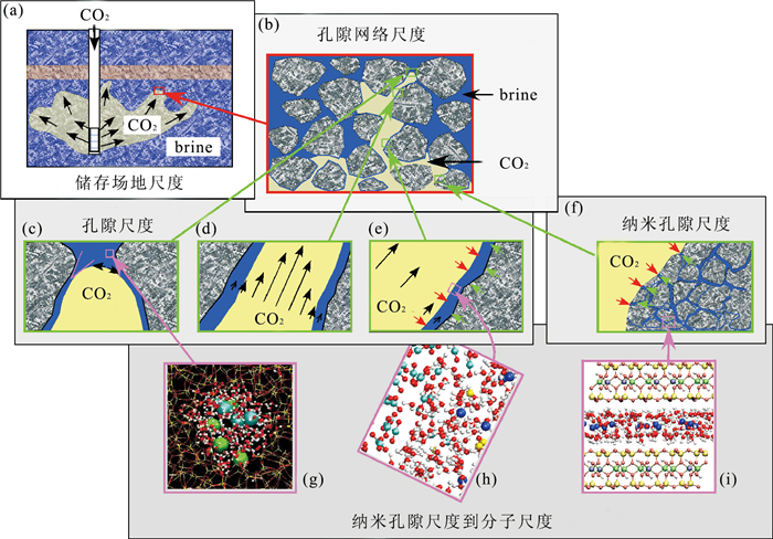
Continuous growth of atmospheric CO2 concentration believed to be the major reason for "greenhouse effect", has become a global environmental issue in recent years. CO2 reduction is a challenge not only for the survival of human society, but also for the development of geosciences and technology. Although there are a variety of approaches to reduce atmospheric CO2, geological storage is considered as an effective way to reduce CO2. Understanding CO2 fluid-rock interaction is the key to successful geological storage of CO2, because of its effects on CO2 injection efficiency, and storage capacity, efficiency, safety and stability of the reservoir. Nanoscale materials have extraordinary properties with their abnormally huge amount of surface atoms and surface energy. CO2 fluid-rock interaction has multi-scale effect, with much higher rate and efficiency at nanoscale than those at other scales, due to substantial differences in surface atoms and surface energy. Therefore, it is critical to reveal the major factors and mechanisms of nanoscale interaction between CO2 fluid and rock to find some natural cost-effective nano-minerals for capture, storage and conversion of CO2.
Continuous growth of atmospheric CO2 concentration believed to be the major reason for "greenhouse effect", has become a global environmental issue in recent years. CO2 reduction is a challenge not only for the survival of human society, but also for the development of geosciences and technology. Although there are a variety of approaches to reduce atmospheric CO2, geological storage is considered as an effective way to reduce CO2. Understanding CO2 fluid-rock interaction is the key to successful geological storage of CO2, because of its effects on CO2 injection efficiency, and storage capacity, efficiency, safety and stability of the reservoir. Nanoscale materials have extraordinary properties with their abnormally huge amount of surface atoms and surface energy. CO2 fluid-rock interaction has multi-scale effect, with much higher rate and efficiency at nanoscale than those at other scales, due to substantial differences in surface atoms and surface energy. Therefore, it is critical to reveal the major factors and mechanisms of nanoscale interaction between CO2 fluid and rock to find some natural cost-effective nano-minerals for capture, storage and conversion of CO2.
2011, 36(1): 172-180.
doi: 10.3799/dqkx.2011.018
Abstract:
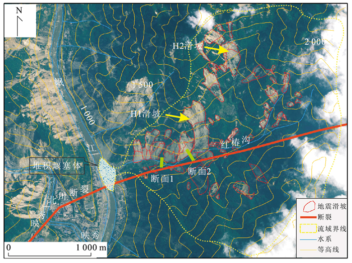
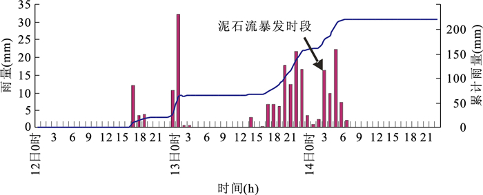
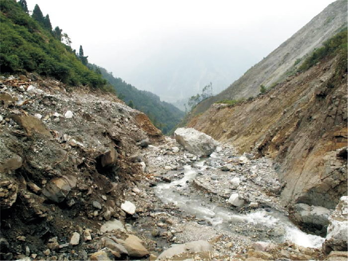
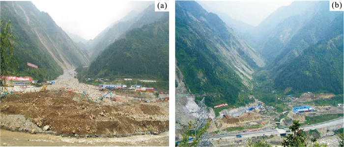
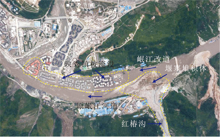
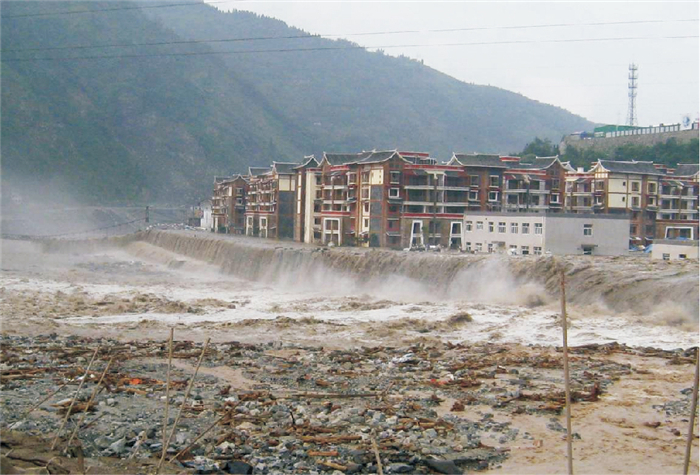
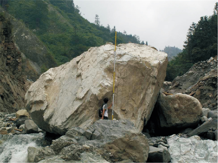
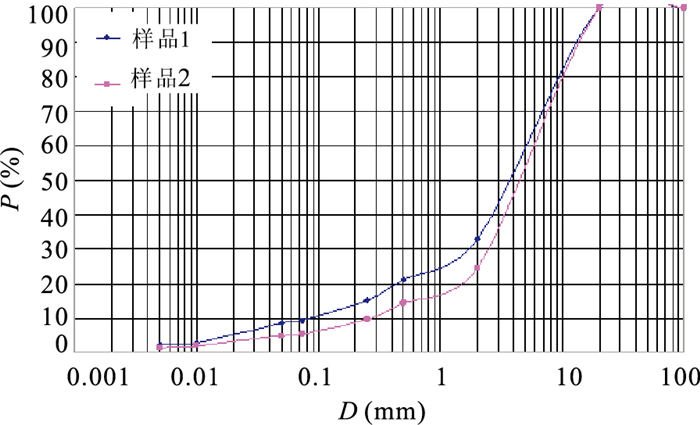
A rainstorm triggered debris flow hazard occurred in Hongchun valley, Yingxiu town, epicenter of the Wenchuan earthquake on August 14, 2010. This event transported huge material sediment to the watercourse of the Minjiang River and produced a natural dam, resulting in flash flood in the new Yingxiu town. The flood claimed 13 lives, with a further 59 listed as missing. About 8 000 local residents were rapidly evacuated from their homes. The debris flow resulted from the coaction of the rainfall and earthquake. Therefore, it is significant for better understanding of development characters of debris flows to conduct the research on the initiation and movement process in high seismic intensity area. This paper studies characteristics of the initiation conditions and depositional fans of the debris flow based on field reconnaissance and interpretations of aerial photographs, focusing on loose sediment supply in source areas of debris flows. On the basis of the above analysis, the initiation and deposition process of debris flows are discussed. The catastrophic event indicates that the areas impacted by the Wenchuan earthquake become more prone to debris flow occurrences in the future. So it is important to assess debris flow risk and take measures to enhance hazard monitoring and offer early warnings for debris flows in the earthquake areas. The control work is also necessary for debris flow hazard mitigation.
A rainstorm triggered debris flow hazard occurred in Hongchun valley, Yingxiu town, epicenter of the Wenchuan earthquake on August 14, 2010. This event transported huge material sediment to the watercourse of the Minjiang River and produced a natural dam, resulting in flash flood in the new Yingxiu town. The flood claimed 13 lives, with a further 59 listed as missing. About 8 000 local residents were rapidly evacuated from their homes. The debris flow resulted from the coaction of the rainfall and earthquake. Therefore, it is significant for better understanding of development characters of debris flows to conduct the research on the initiation and movement process in high seismic intensity area. This paper studies characteristics of the initiation conditions and depositional fans of the debris flow based on field reconnaissance and interpretations of aerial photographs, focusing on loose sediment supply in source areas of debris flows. On the basis of the above analysis, the initiation and deposition process of debris flows are discussed. The catastrophic event indicates that the areas impacted by the Wenchuan earthquake become more prone to debris flow occurrences in the future. So it is important to assess debris flow risk and take measures to enhance hazard monitoring and offer early warnings for debris flows in the earthquake areas. The control work is also necessary for debris flow hazard mitigation.