2022 Vol. 47, No. 1
 PDF 275KB
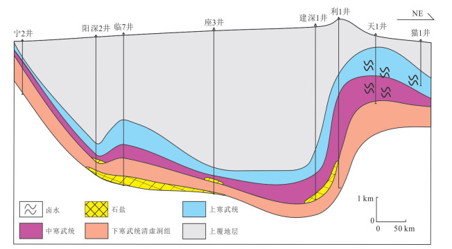
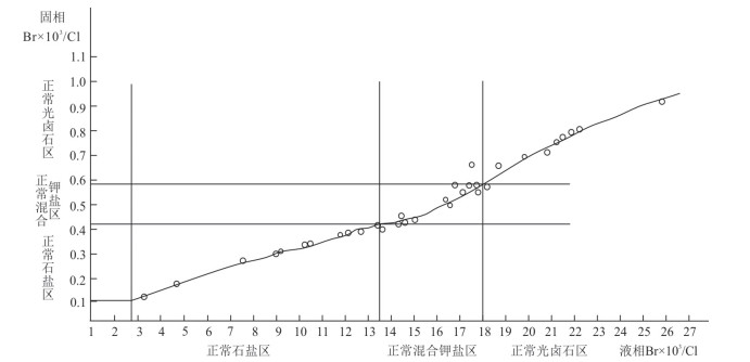
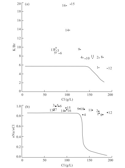
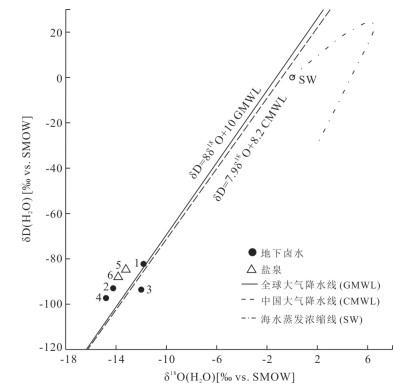
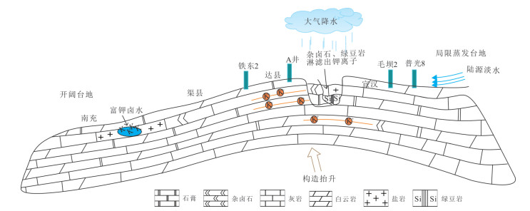
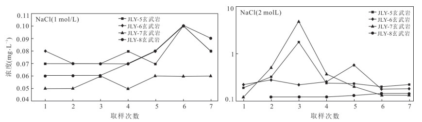
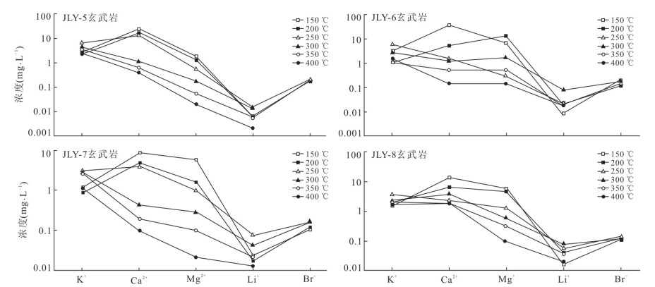
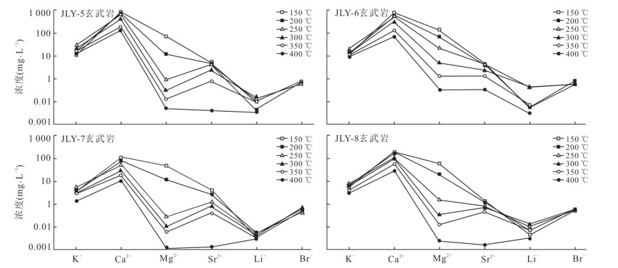
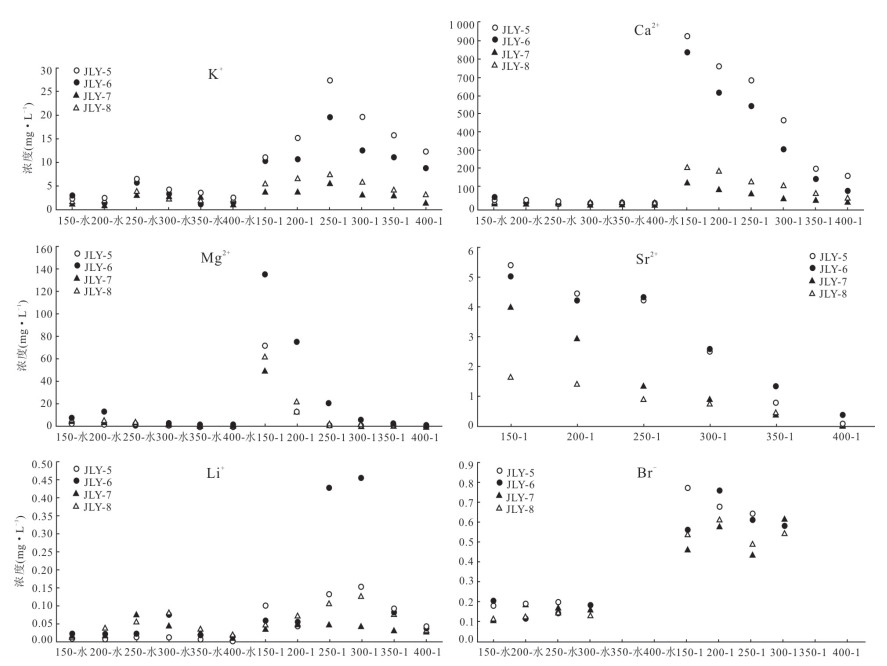
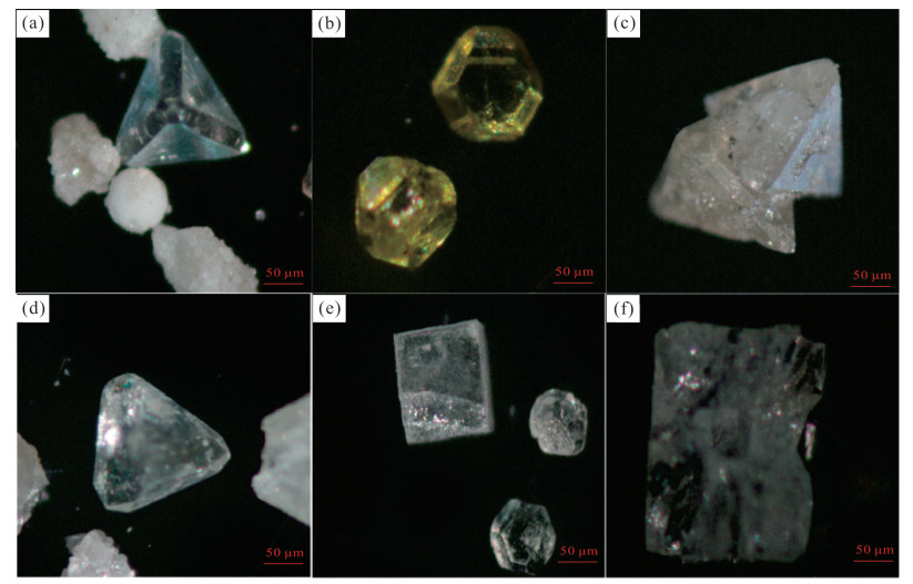
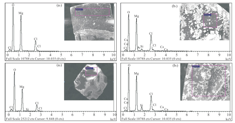
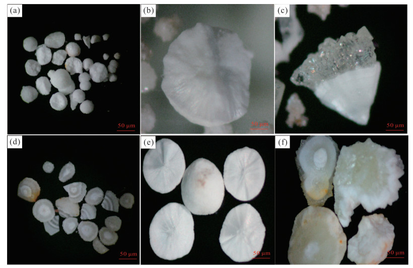
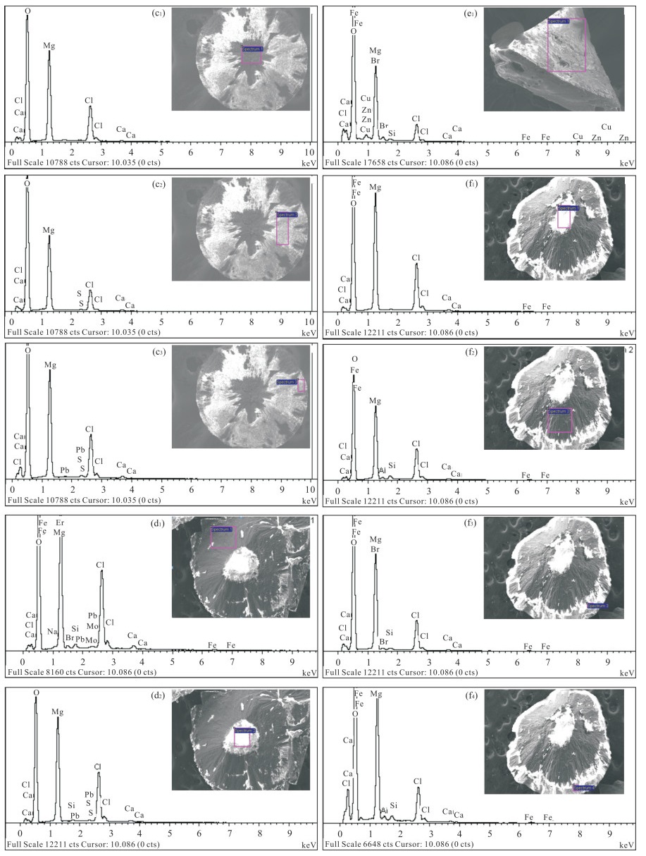
Through summary of long-term work, it is found that the value of Br×103/Cl, which is commonly used, is low. In this paper, it innovatively clarifies the index system for potassium prospecting of marine evaporative basin by using the "ancient test" leaching experiment and geological statistics method. This method fully considers the changes of seawater composition in different geological years and can also overcome the insufficiency of data for applying modern seawater under isothermal and pressure conditions. Through the leaching experiment of rock salt, potassium-bearing salt and potassium salt (including carnallite) of the typical potash deposits in the world, and combining the previous evaporation experiment results of sea water and marine brine, the index system for potassium prospecting in mineral deposit: Br×103/Cl, K×103/Cl, K/Br, nNa/nCl, nMg/nCl, is summarized. This study aims to trace the origin of the brine which is Cambrian deep brine from Tianxingqiao structure of Northeast Sichuan Basin by analyzing its hydrochemical characteristics (weight ratios of Br×103/Cl, K×103/Cl and K/Br, and molar ratios of nNa/nCl and nMg/nCl). The results show that the hydrochemical characteristics and δD and δ18O values of the brine from Tianxingqiao are similar to those of the brine from dissolution and that of the salt precipitates, but have distinct difference from that of the primary brine. Therefore, it is believed the formation brine from Tianxingqiao is sourced from meteoric water and the brine salinity come from saliferous strata, which might come from the dissolution of halite beds or even the sylvinite beds. This finding is in contrast to the previous studies which held that the brine is primary brine. This study provides new and important information for searching potash deposits in this area.
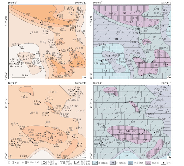
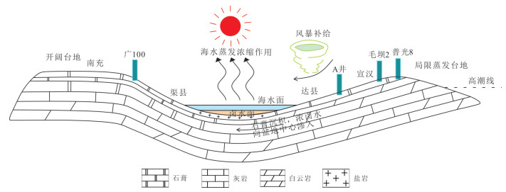
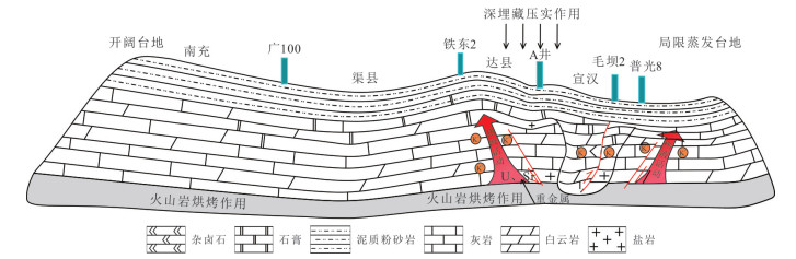
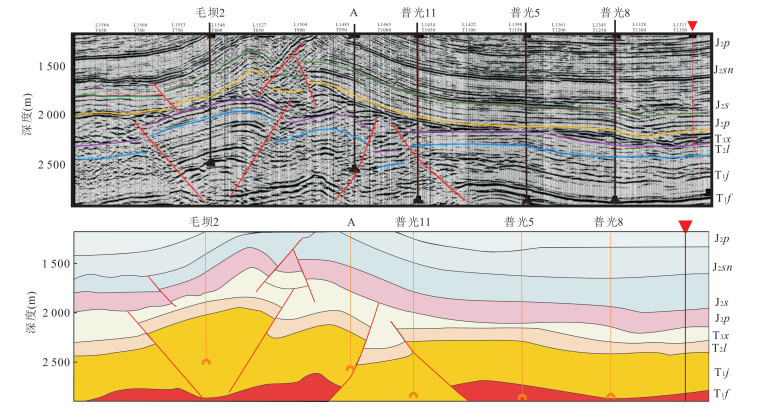
During the Triassic period, the Northeast Sichuan developed a huge evaporative salt layer and accumulated high quality deep potassium-rich brine. Due to the overall differences in tectonic depositional conditions, the genetic mechanism and enrichment rules of potassium-rich brine in Northeast Sichuan Basin have not been studied in detail. In this study it takes "gas-potassium exploration" as the guiding ideology, and comprehensively utilizes the field outcrop-core-logging data to analyze the distribution and lithofacies paleogeographic evolution of the Triassic evaporite in the Northeast Sichuan basin, and finally it shows the size of salt basin in Northeast Sichuan decreased gradually and migrated to southwest during T1j4-5-T2l1. Combined with core and brine geochemical analysis, it is concluded that the genesis mechanism of potassium-rich brine in Northeast Sichuan is mainly seawater evaporation-concentration mechanism and surface fresh water leaching mechanism, and the deep water-rock reaction is weak. Combined with well logging and seismic interpretation, it is proposed that the potassium-rich brine has the enrichment rule of "controlling brine by the gypsum basin and salt basin; storing brine in the pores and fractures; enriching brine in the core of anticline". It is considered that the potassium-rich brine is a "secondary deep depression" enrichment model controlled by "structure-deposition" dual factors.
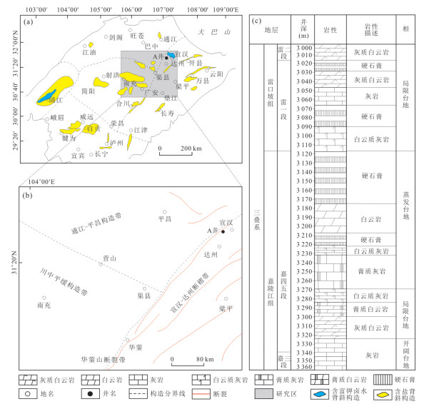
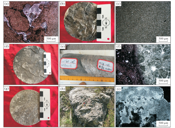
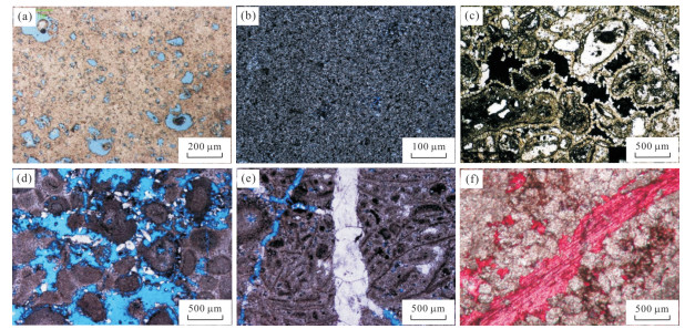
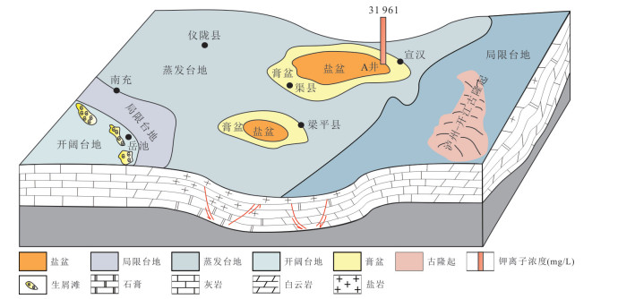
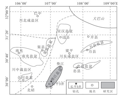
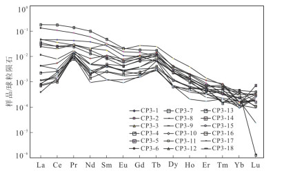
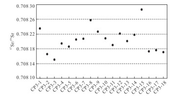
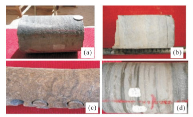
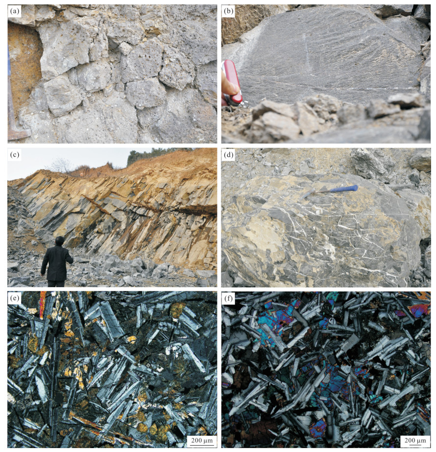
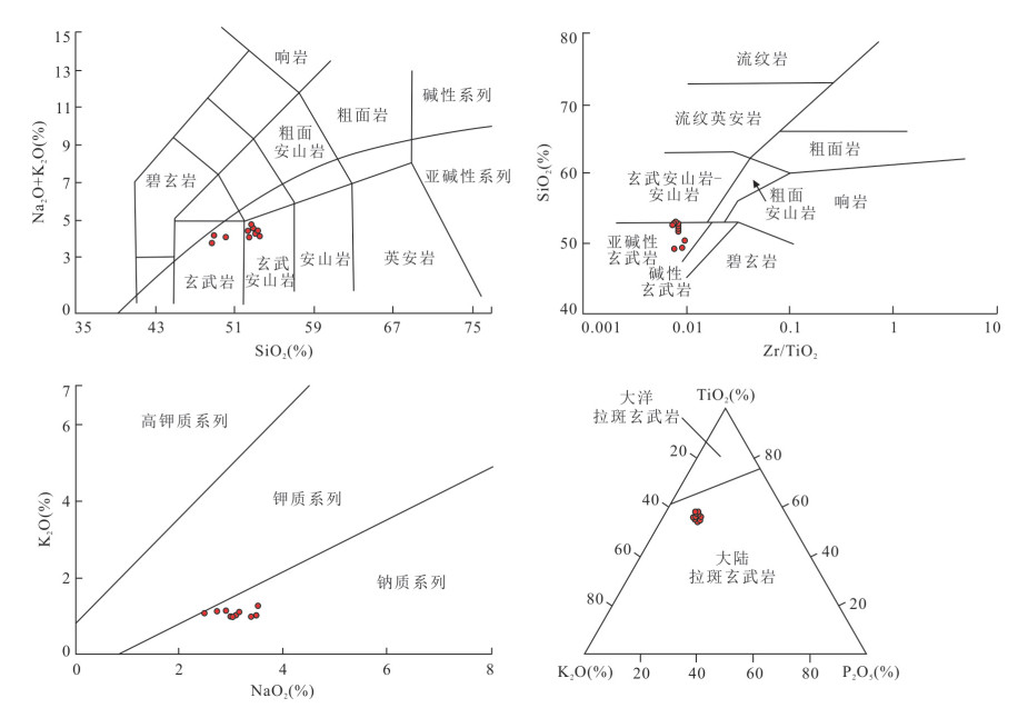
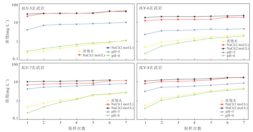
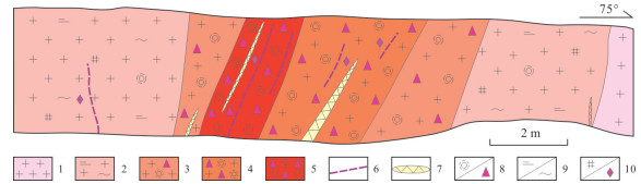
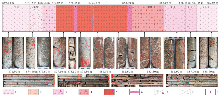
The Triassic witnessed the significant potash formation in Sichuan Basin. So far, the main potash mineral reported is mostly polyhalite, while the origin of polyhalite in the fourth member of Jialingjiang Formation in eastern Sichuan Basin still remains controversial. In this paper, it employs the thin section identification, scanning electron microscope (SEM) and geochemical measurements (including rare earth element and strontium isotope), analyzing the polyhalite samples from the fourth member of Jialingjiang Formation, eastern Sichuan Basin in detail. The microscope and SEM photographs show that the polyhalite which is in intergrowth with halite has well euhedral and few structural defects. The characteristics of rare earth element are relatively enriched in LREE and depleted in HREE, with weak negative Eu and Ce abnormities, which are similar to those of the seawater. In addition, strontium isotopic values of the halite samples (Changping 3 Well) are between 0.708 151 and 0.708 286, which are basically consistent with the seawater values in the Triassic. All these evidences indicate that the source of halite and polyhalite was the products of highly concentrated seawater. In this paper, it holds that the polyhalites in the fourth member of Jialingjiang Formation in eastern Sichuan Basin were mainly primary polyhalites, and the seawater was highly concentrated and had approached or reached the critical point of potassium and magnesium salts precipitation. It infers that Changping 3 Well is close to the concentration center of Dianjiang Salt Basin, and the nearby area is the suitable place for the formation and preservation of potash deposit.

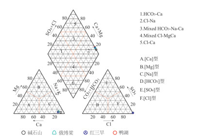
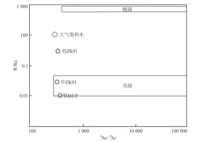
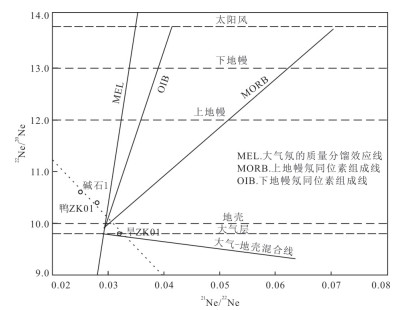
The structural fissure and pore brine in western Qaidam Basin is the most important deep brine resources in China, and its causes have been debated over many years. In this paper, it discusses its geochemical causes by studying its major, trace element characteristics and He, Ne, Ar isotopes of the brine samples from the Jianshishan, Hongsanhan Ⅳ, Eboliang Ⅱ and Yahu areas in western Qaidam basin. It is shown that the sodium-chloride coefficients of structural fissure and pore brine in western Qaidam Basin range from 0.84 to 0.91, the potassium coefficients range from 3.19 to 12.35, the potassium-chlorine coefficients range from 5.26 to 20.61 and the desulfurization coefficients range from 0.33 to 2.00. The brine type is shown as the Cl-Na type on the Piper plot. The 3He/4He ratios range in 0.01-0.16 Ra, the 40Ar/36Ar ratios range from 318 to 352, the 38Ar/36Ar ratios range from 0.182 to 0.193, the 20Ne/22Ne ratios range from 9.8 to 10.6 and the 21Ne/22Ne ratios range from 0.025 to 0.032. Therefore, it is believed that the salt components formed by rock weathering were migrated to the basin by groundwater at first, and then evaporated into salt deposits, after being buried, the water-rock interaction occurred between these salt deposits and deep groundwater and then were enriched to form the structural fissure and pore brine with a high mineralization.
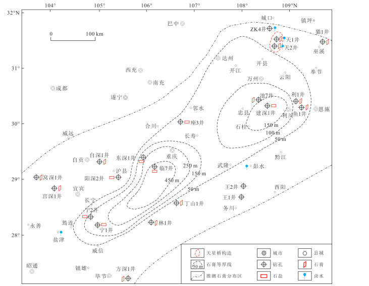
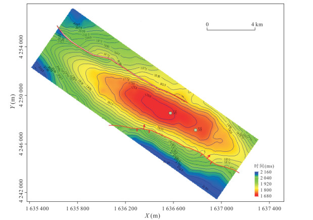
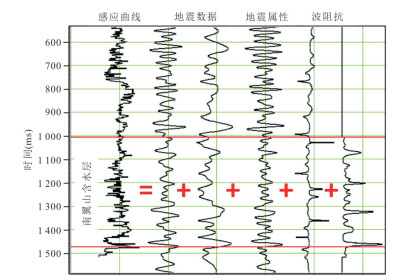
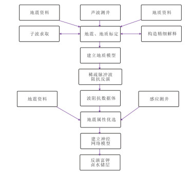
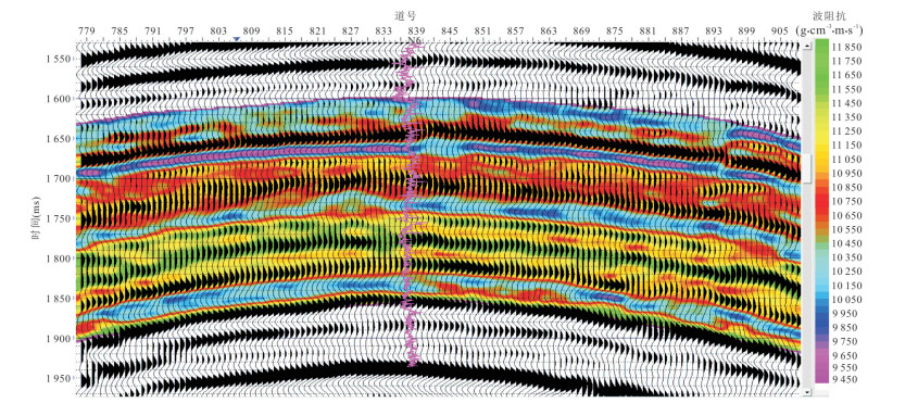
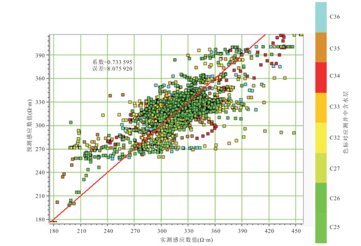
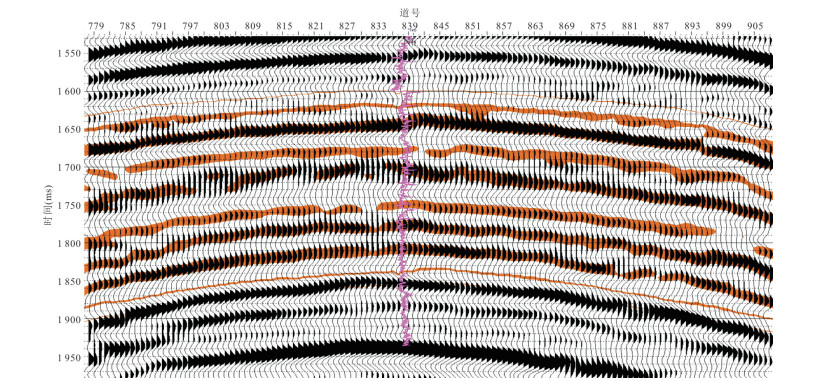
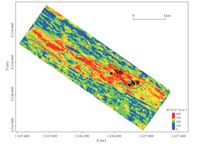
The survey of oil wells shows that deep brine containing useful elements such as lithium and potassium is widely distributed in the oil storage structure area represented by Nanyishan in the west of Qaidam. The brine is distributed from the Paleogene to the Neogene and has great social and economic values. According to the structural and stratum lithology characteristics, the brine storage space is considered to be pores and fractures. As the response characteristics of the aquifer in the acoustic logging curve are not obvious in the Nanyishan area, it is difficult to effectively identify the brine reservoir by the traditional impedance inversion technology with acoustic logging as a constraint. There is still no suitable method to identify the occurrence state of this type of brine in each layer. For this reason, in this study it combines seismic information with induction logging information that has a more obvious response to the brine layer based on the neural network joint inversion technology, and uses the strong extraction ability to feature pattern of neural network and integrates induction logging, seismic waveform, seismic attributes, impedance and other data to obtain a three-dimensional induction data volume that can more accurately reflect the lithium-potassium brine reservoir, which improves the identification ability of the brine reservoir. In the paper it provides an important basis for predicting the vertical and horizontal distribution of potassium-rich lithium brine in Nanyishan.
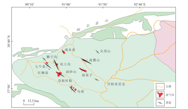
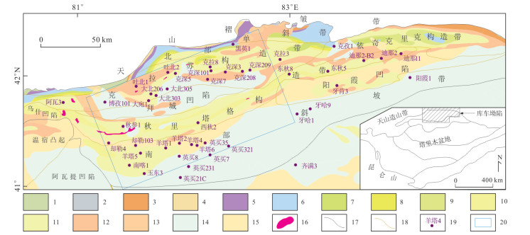
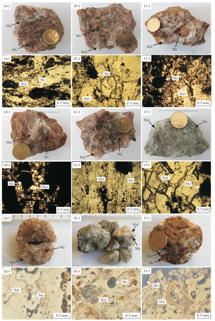
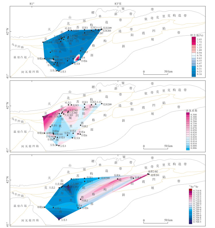
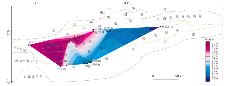
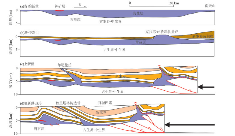
The Paleogene solid potassium salt mineralization has been found in the deep layer (5 141-5 218 m) of western Kuqa Depression, but it is still necessary to further study on the characteristics of gypsum-salt layer, potash conditions and potash-prospecting in the region. Taking the gypsum-salt layer debris in deep oil and gas drillings as object, in this paperit performs research on sedimentary and petrological characteristics of gypsum-salt layer, as well as potassium content, bromine-chlorine coefficient, Sr and S isotopes and other characteristics in western Kuqa Depression. Besides in this paper it also analyzes the salt tectonic characteristics and evolution in the region. The results show that the potassium and bromine-chlorine coefficients are good in Quele-Yangta belt in the south of the Qiulitage tectonic zone, which proves to be a good condition for potash formation. Sedimentary characteristics of Kumugeliemu Group, potassium content, bromine-chlorine coefficient, Sr and S isotopic characteristics indicate the potential potassium formation in the Dabei area, north of the Qiulitage structure belt. Sedimentary characteristics of Kumugeliemu Group and the analysis of the salt structure evolution reveal that Quele-Yangta belt is a favorable secondary depression for potassium in the salt-forming period, which is better preserved in the later period. It is considered that Quele-Yangta belt which is located in the south of Qiulitage tectonic zone in the western Kuqa Depression is the most advantageous area for potassium exploration, besides, there are several potash prospecting areas in the north of Qiulitage, including Dabei district.

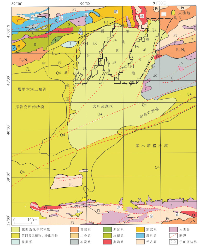
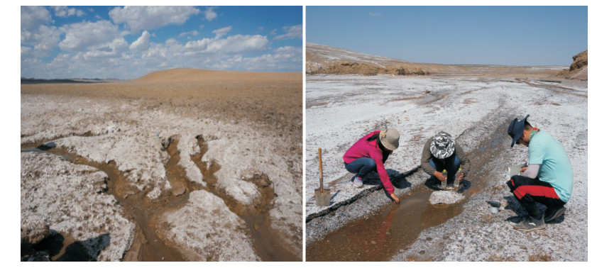
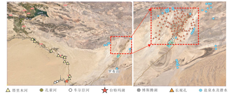
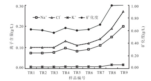
Lop Nor is the largest single sulfate-type liquid potash deposit in the world, and the genesis of the deposit has been controversial. In this paper, the genesis of potassium-rich brine deposits in Lop Nor is discussed from the perspective of hydrochemistry, based on a large number of measured chemical data of salt springs, underground phreatic water and surface water. The results show that the sodium-chlorine coefficient of potassium-rich brine is 0.76-1.24, and the potassium-chloride coefficient is 38.58-60.49. The main body of the brine shows the characteristics of dissolving-filtering brine, indicating the mixing of brine from other sources. It is the first time that Ca-Cl type brine is found in the eastern fault zone of Lop Nor basin and Dawadi, which shows typical characteristics of enrichment in Na+, K+, Ca2+, Cl- and depletion in HCO3-, CO32-, and SO42-, indicating deep hydrothermal supply in Lop Nor Basin. In the ore-forming process, the Ca-Cl type brine can change the composition and crystallization route of the original ore-forming brine directly through the effect of "mixing brine", so that its mineralization degree is increased, and it is rich in K and Na. The reformed "sodium-rich" brine reacted with gypsum (CaSO4·2H2O), and formed glauberite (Na2Ca(SO4)2·2H2O), which existed among the porous glauberite crystals, forming super-high salinity potassium-rich brine.
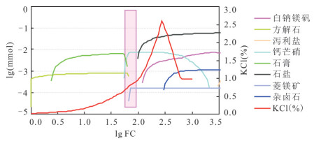
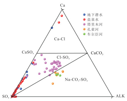
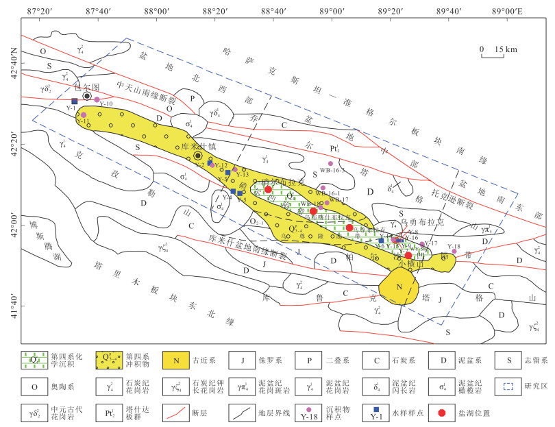
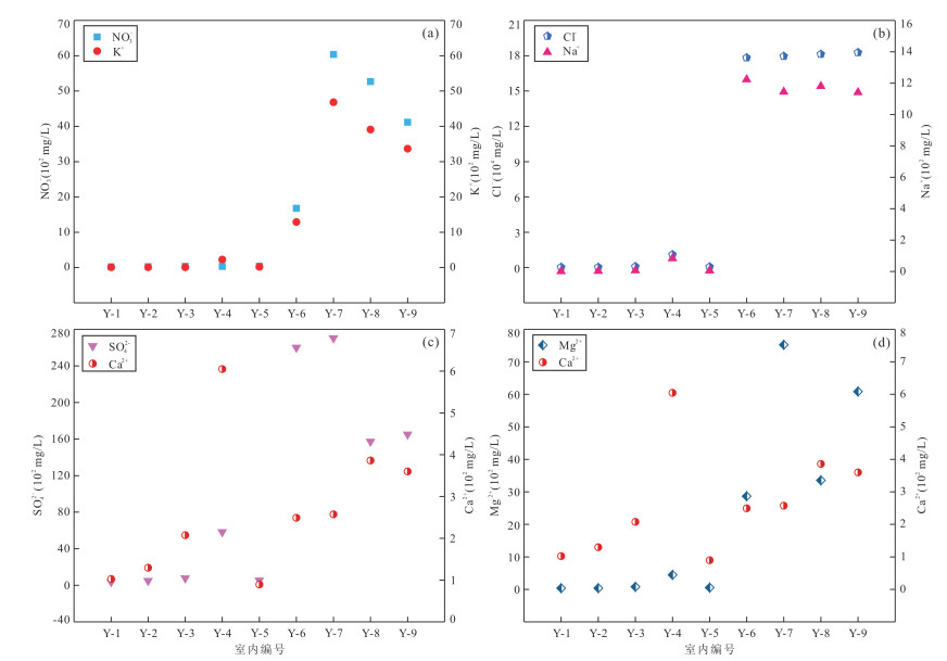
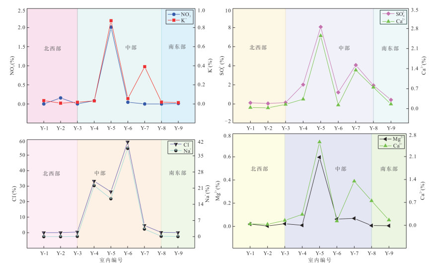
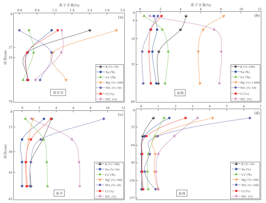
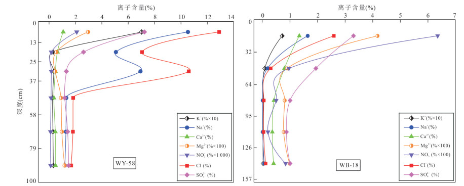
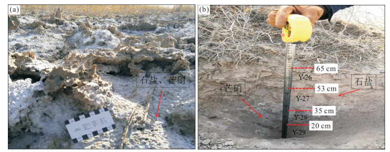
In order to understand the spatial distribution characteristics of ore-forming ions and the reason for high nitrate content in surface sediments of nitrate deposits in Kumishi Basin. In this study it focuses on the nitrate deposits in the basin, and a quantitative analysis of the chemical composition of soluble salts in various make-up water samples and soil samples was carried out in the study area. Combined with field geological exploration work, the migration regularity of ore-forming ions in nitrate deposits is discussed. Besides, a model of sedimentary mineralization of nitrate deposits in the basin was established. The results show that ore-forming ions such as K+, Na+, and NO3- migrate and enrich from northwest and southeast toward the middle of the basin. The concentrations of K+, Na+, NO3- and other ore-forming ions gradually increase along the direction of the bedrock area-fan root-middle fan-fan margin in the diluvial fan in the northeast of the basin, and enrichment occurs in the surface sediments at the fan margin. In the vertical profiles, K+, Na+, NO3- and other ore-forming ions mainly show migration and enrichment in the depth range of 0-60 cm. Under the influence of capillarity, they migrated and enriched from deep to surface sediments.
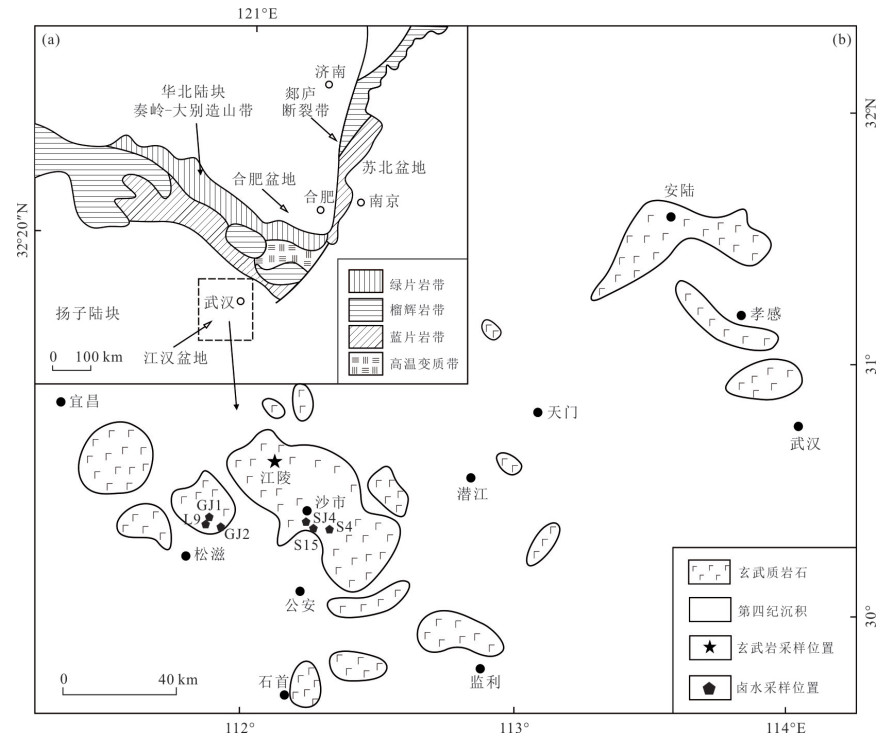
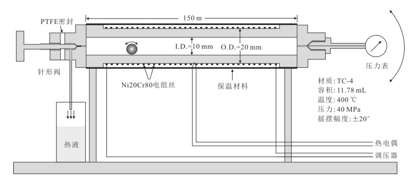
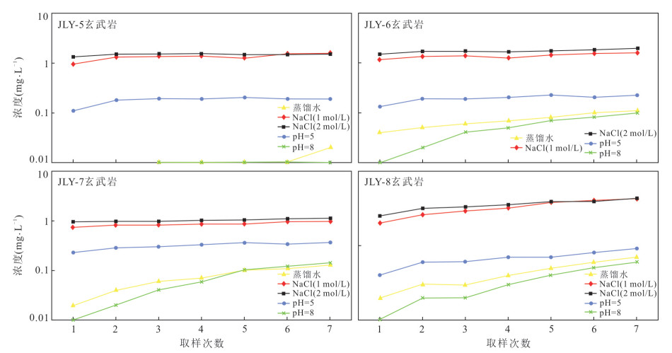
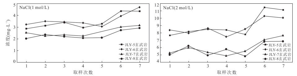
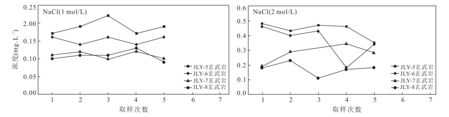
The material source and genesis mechanism of the potassium-rich brine in Jiangling Depression have not yet been ascertained. Mineralogical, petrological, geochemical analyses and water-rock reaction simulation experiments on Cenozoic basalts were carried out in Jiangling Depression, focusing on the effects of time, temperature, and fluid composition on the water-rock reaction. The study shows that the brine has the characteristics of high lithium and low magnesium. It shows that the origin of brine was controlled by volcanic activity. The magma in the study area was differentiated to different degrees, and the basalt alteration was strong, indicating that the subsurface hydrothermal fluid had a strong metasomatism on the basalt in the study area. Basalt provided material source for potassium-rich brine ore through water-rock reaction. Temperature is the main controlling factor of the eluvial capacity of the fluid, and the high salinity fluid is the main carrier of the ore-forming elements. Water-rock reaction is an important process of brine formation.
Massive Cretaceous-Paleogene evaporates with lithium (potash)-rich brines develop in Jitai Basin of South China, of which deep structural characteristics remain unclear so that no breakthrough progress has been made in the exploration and evaluation of brines. According to 2D seismic survey and drilling in Taihe Depression, it summarizes structural pattern and characteristics of the brine-bearing basin by means of refined relative-amplitude-preserved seismic processing and integrated interpretation. Seismic profiles and structural attributes show that one NE-SW normal fault southward sloping down to the basin basement and inner strike-slipping faults in low uplift of Gaopi-Meigang lead to more fractures yielded within Maodian, Zhoutian and Honggang formations. By the reservoir tracking to Meigang lithium-bearing brines and the lithological analysis, it is concluded that the normal fault and the fractures form migration pathways of deep brines moving upward. Meanwhile, much of lithium-rich brines can be predicted within deep Cretaceous strata.
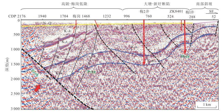
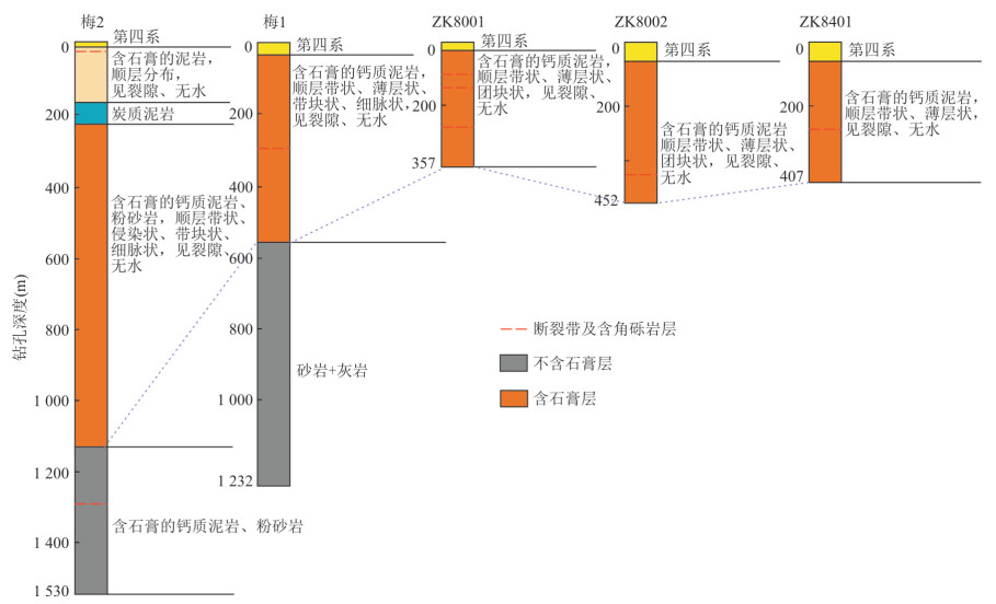
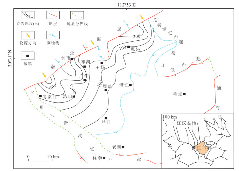
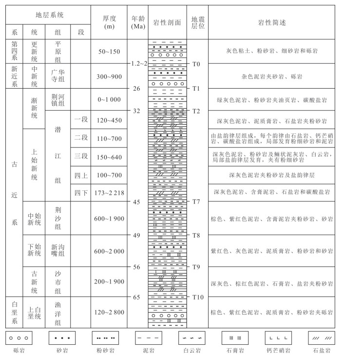
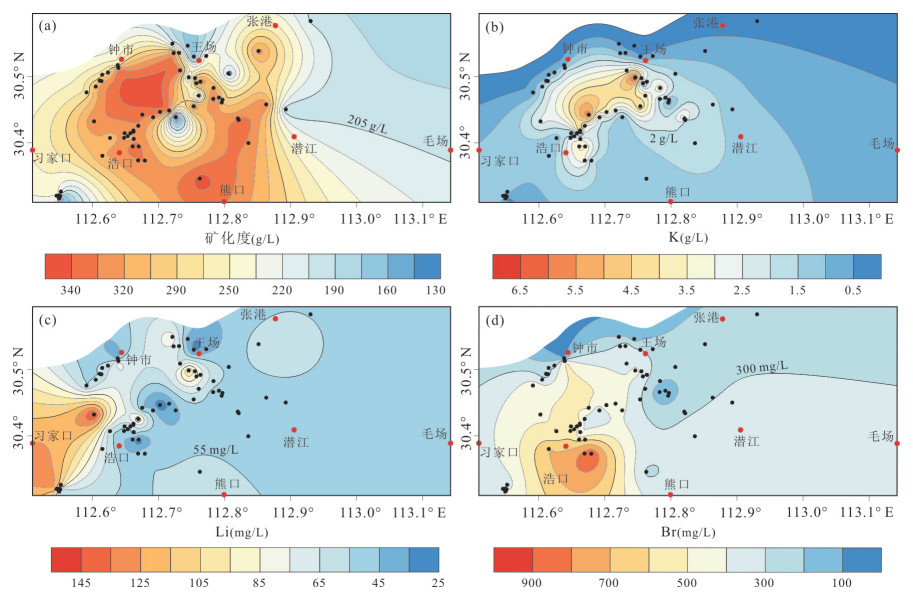
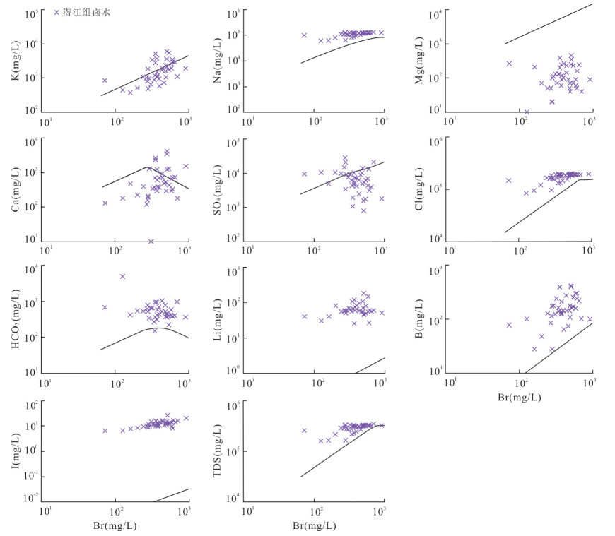
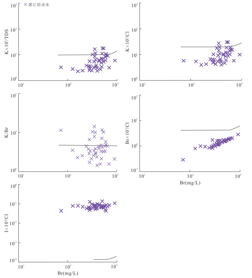
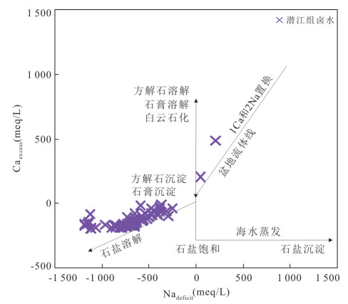
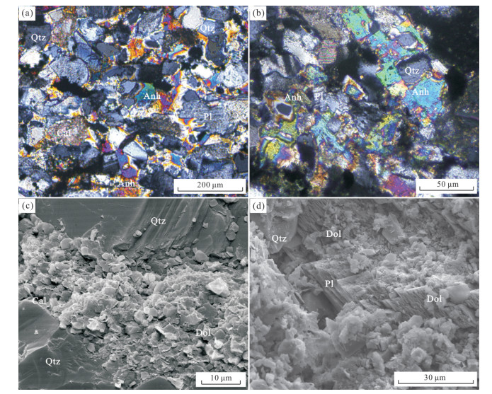
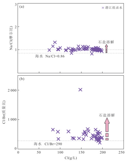
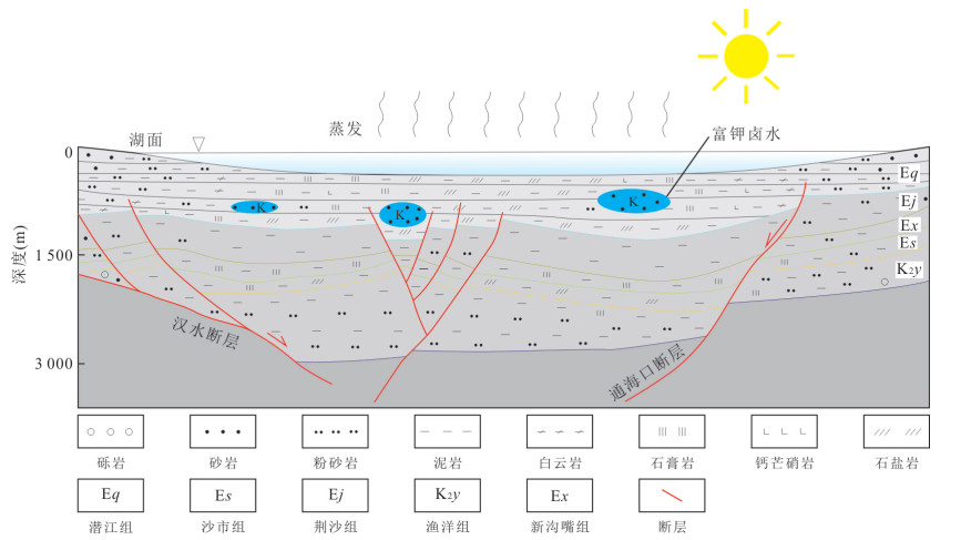
Deep-seated K-rich brine is a very important potash resource. However, there are few systematic studies on the chemical characteristics and genesis of K-rich brine in sedimentary basins on a regional scale. The major and trace element analyses of the deep-seated K-rich brine in Qianjiang Depression were carried out. The brine salinity in the study area is 125.70-347.00 g/L, and the K content is 0.32-6.83 g/L; Li, B, I, Na, Cl are enriched, Mg and Br are depleted, and Ca and SO4 are either enriched or depleted. Mineralogical features of reservoir rocks, the Nadeficit and Caexcess values as well as the molar ratio of Na/Cl (0.83-1.32) and the mass ratio of Cl/Br (212-2 017) indicate multiple water-rock reaction processes. The brine in the basin has undergone two main stages of evolution: during the depositional period of the salt-bearing strata in the salt lake, the precipitation of salt minerals such as gypsum, glauberite, potassium- and magnesium-bearing sulfate led to the initial enrichment of K, and the diagenesis processes such as anhydrite and calcite cementation and dolomitization in the reservoir caused a change in the composition of the brine; during the tectonic deformation and erosion period, the halite and potassium-containing salt minerals were dissolved by shallow or surface waters, leading to the further enrichment of K.
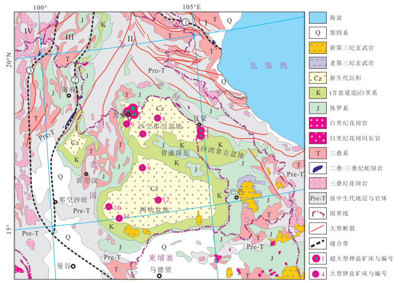
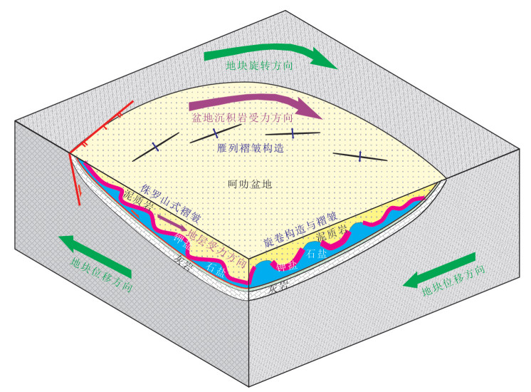
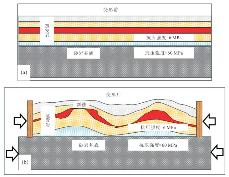
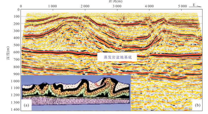
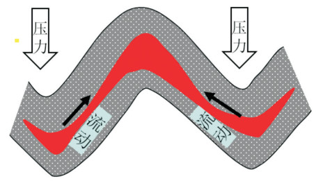
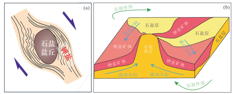
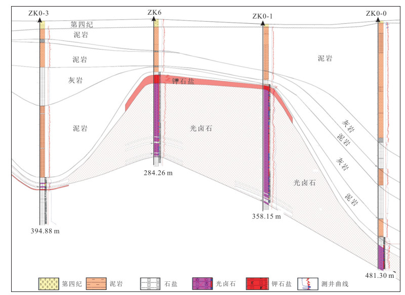
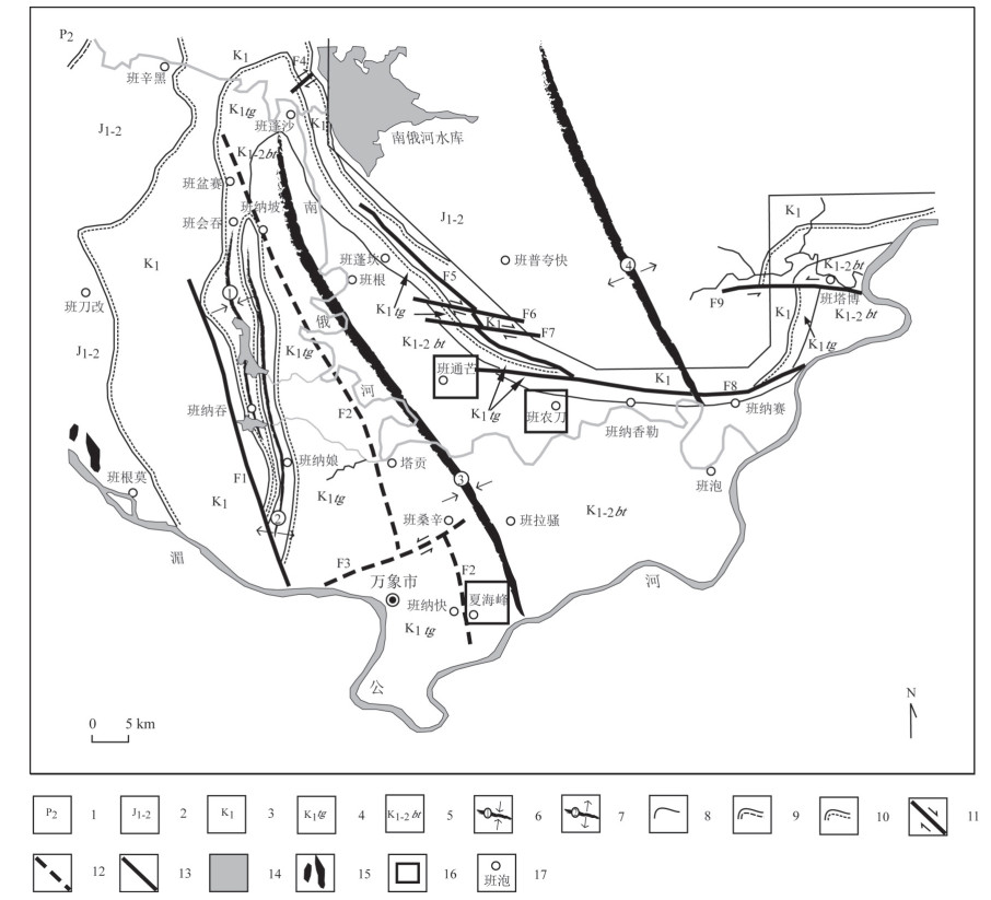
The Khorat Basin is an important potash basin in the Tethys metallogenic belt, but the exploration and development of potash deposits in this area are severely restricted due to the unclear deformation structure and the distribution rules of potash salts. Based on the analysis of macro-regional tectonic evolution, taking a small region in the Vientiane Sag as an example, under the strict constraints of high-precision 3D seismic exploration and drilling natural gamma logging, the underground accurate structural changes and potash ore distribution data were obtained. Combined with the deformation characteristics of salt structure and seismic exploration profile, the geological interpretation was carried out. The results indicate that the squeeze, slip, and rotation of the Indosinian block have strongly transformed the potash deposits in the Khorat Basin. Three types of potash deposit transformation models are summarized, including evaporite Jura type fold deformation model, differential load enrichment modes under stress, enrichment mode rotating around hard salt mound.
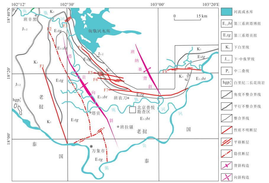
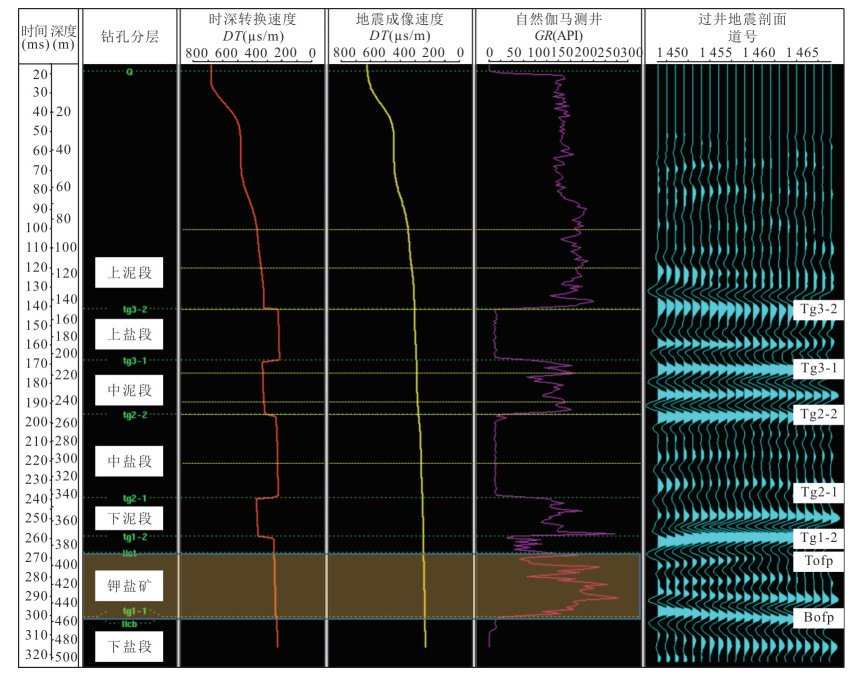
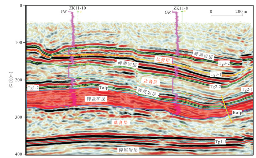

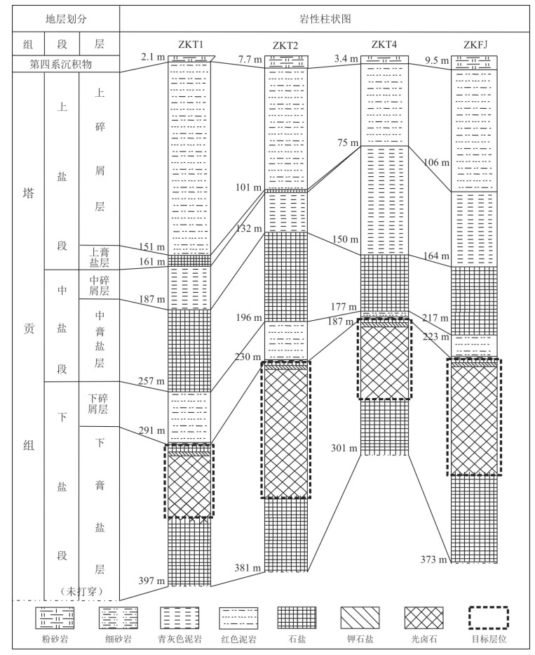
There exist abundant potassium resources in Vientiane Basin of Laos. These huge evaporites or potash deposits are important materials for studying formation and evolution of ancient evaporites and seawater. The salt-bearing construction of the Vientiane Basin in Laos contains three evaporite-clastic sedimentary rhythms, while the potassium-magnesium salt deposits are present at the top of the lower salt section. Through the extraction of borate minerals from the potassium-magnesium salt deposits in the Thongmang potash mine in Laos, it is found that there are two forms of borate minerals in the late stage of potassium formation, namely boracite single crystal and oolitic boracite. According to the analysis, the content of boracite single crystal in the borehole is less; while the oolitic boracite is more distributed and basically present on the top of the potassium-magnesium salt layer, and the regular distribution of oolitic boracite shows that the sedimentary environment is a turbulent shallow water environment. Both the boracite single crystal and oolitic boracite are formed in a high-energy environment, and the oolitic boracite is of great significance to invert the salt-forming environment.
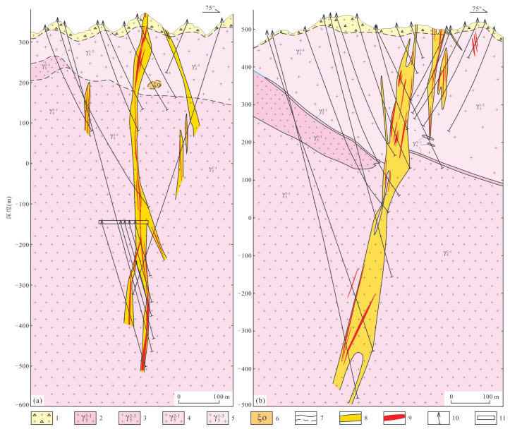
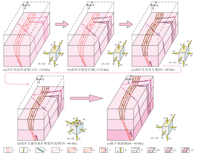
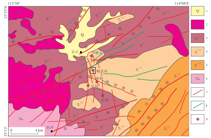
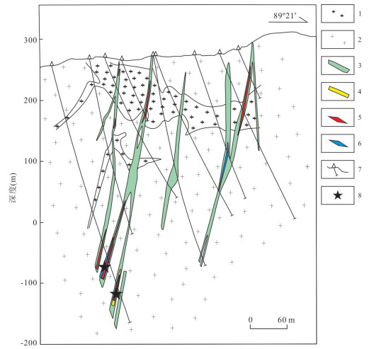
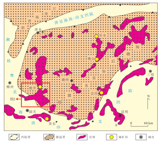
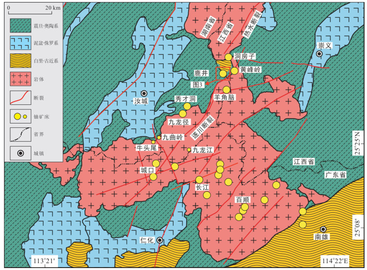
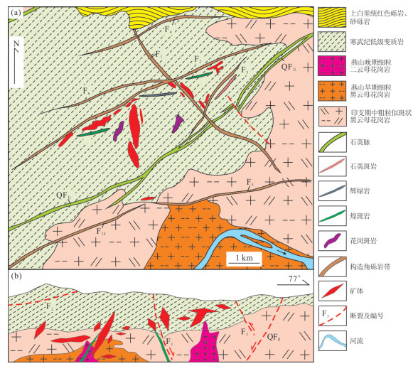
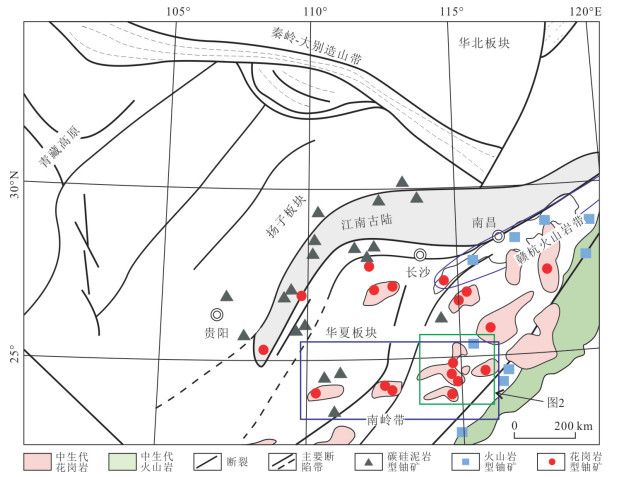
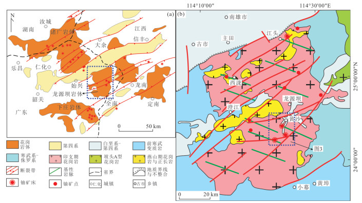
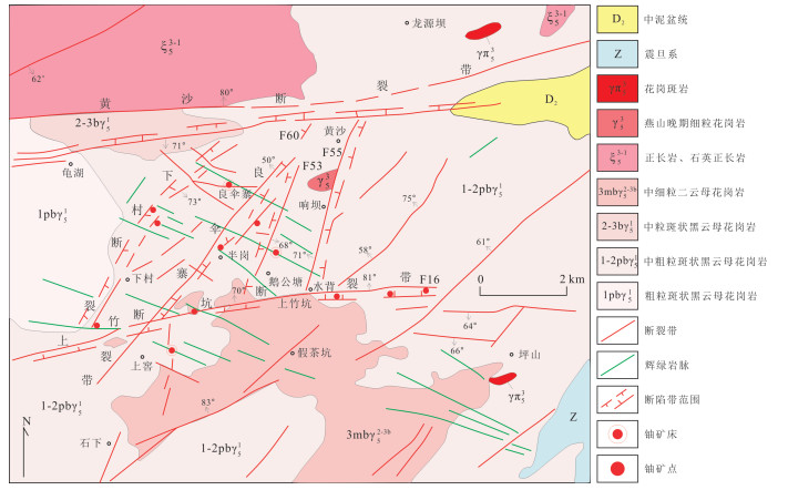
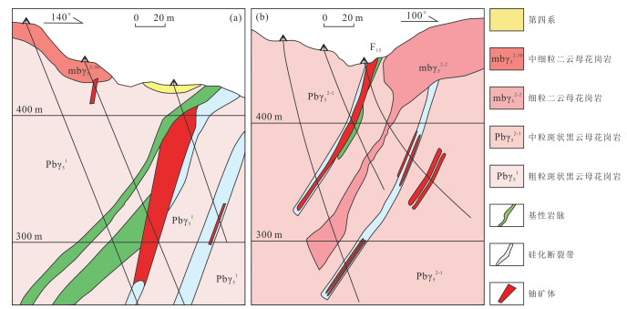
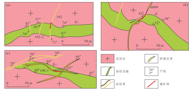
The study of ore-controlling structures is still weak in the Changjiang uranium ore field, which has restricted the understanding of metallogenic regularity and future prospecting direction. Through detailed analysis of ore-controlling structure in ore field, the authors determined the ore-controlling structure form, constructed a structural ore-controlling model, discussed the evolution of ore-controlling structure, and pointed out the prospecting direction in this study.It is found that uranium ore bodies and mineralization belts in the ore field are controlled by NNW-trending (near SN-trending) fault structure and are characterized by a long strike extension, a large dip depth, a stable occurrence with some arcuate shape and belted groups, which indicates that the ore-bearing structures are compressive or/and compresso-shear fault (closely spaced joint or/and cleavage belt) forming under an EW-trending compressive stress field. However, the ore controlling structure in the ore field is a larger scale NNW-trending (near SN-trending) fault structure system (or main fault), in which deep part links the ore-forming solution in depth and acts as passage-way for the ore fluid and shallow part links the ore-bearing NNW-trending (near SN-trending) fault structures. They not only act as the host space but also control the occurrence of ore-bodies. The ore-controlling structure went through five stages as forming stage of ore-bearing structure, emplacement stage of basic dike, metallogenic stage, forming stage of brittle fracture after mineralization and uplifted-exhumation stage, finally appearing the present state. The Youdong fault is not a high degree ore-controlling structure, it only acts as ore-bearing structure. The Mianhuakeng fault maybe occurred after mineralization. On the basis of the ore-controlling structure, the further prospecting for uranium deposits should be along the NNW-trending (near SN-trending) fault belt, concentrated in the strike extending area and deep dipping area. In the meantime, there is a good chance for concealed ore zone in the blank area between existing ore zone at surface and shallow part.

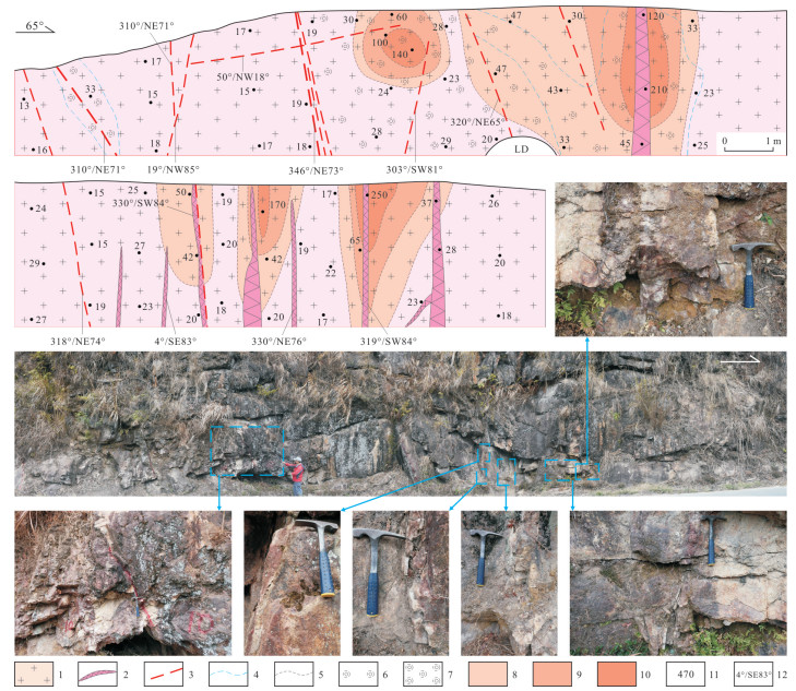
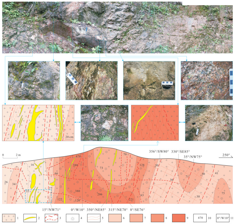
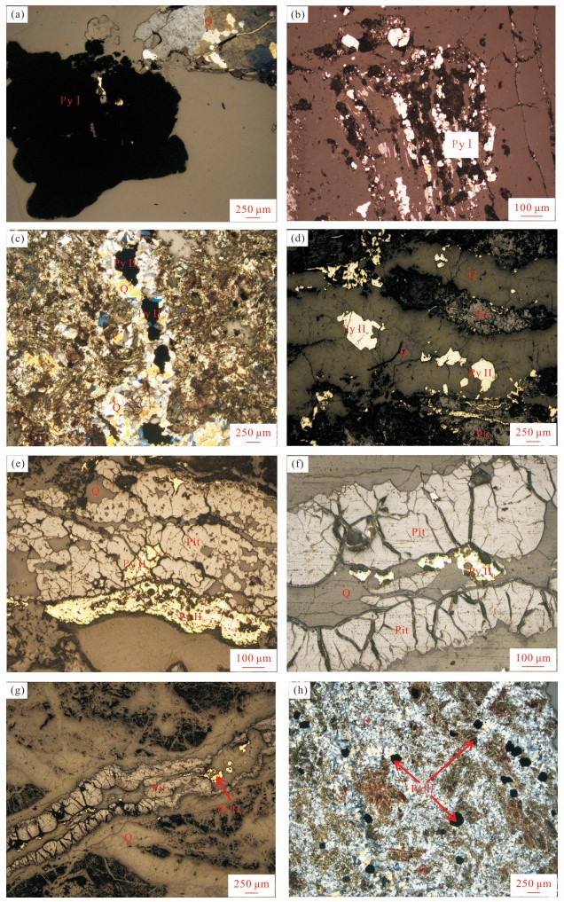
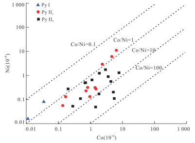
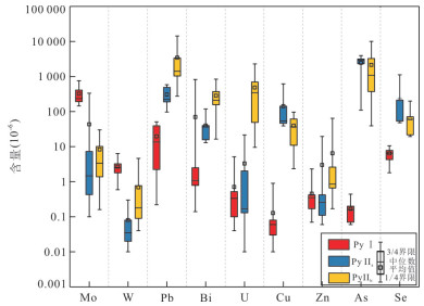
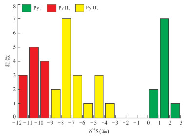
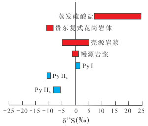
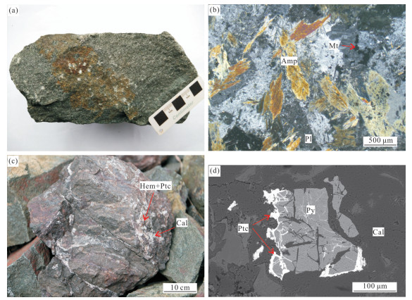
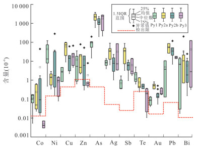
The Shulouqiu uranium deposit is an important part of Changjiang uranium ore field. However, there are relatively fewer studies on its ore-forming fluid properties, source and metallogenic environment. Based on the characteristics of pyrite and other mineral paragenesis, the formation of pyrite in the Shulouqiu uranium deposit is divided into three stages: pre-metallogenic period (Py Ⅰ), syn-metallogenic period (Py Ⅱ) and late-metallogenic period (Py Ⅲ). Meanwhile, the syn-metallogenic period (Py Ⅱ) is divided into early metallogenic stage (Py Ⅱa) and main metallogenic stage (Py Ⅱb). The trace elements and sulfur isotopes of pyrite formed in different periods were analyzed by inductively coupled plasma mass spectrometry (LA-MC-ICP-MS). The results show that the content of Co and Ni of Py Ⅰ is mostly lower than that of the test line, and the ratios of Co/ Ni of Py Ⅱa and Py Ⅱb are mainly 1-5, suggesting that it is the cause of hydrothermal. The δ34S value of Py Ⅰ ranges from +0.41‰ to +2.02‰, which is mantle sulfur. The δ34S value of Py Ⅱa ranges from -9.15‰ to -11.3‰, which is similar to that of the Py Ⅱa (-10.9‰ to -7.10‰) in the Guidong compound granite. Meanwhile, it has the same origin as the Zhuguang compound granite, indicating that the sulfur of Py Ⅱa comes from the Zhuguang compound granite. From the early metallogenic stage to the main metallogenic stage, the δ34S values of pyrite increase from (-9.15‰ to -11.3‰) to (-4.58‰ to -8.48‰), indicating that the oxygen fugacity of ore-forming fluid decreases. Uranium-rich fluid migration was formed in the oxidized fluid leaching of ore-bearing rocks in the early stage of mineralization, and uranium-rich fluid was changed into reducing environment in the main metallogenic period, which resulted in uranium precipitation. Combined with the characteristics of pyrite trace elements, the fluid in the early stage of uranium deposit in Shulouqiu is a high temperature magmatic hydrothermal, and the fluid in the metallogenic period is a medium-low temperature meteoric water.
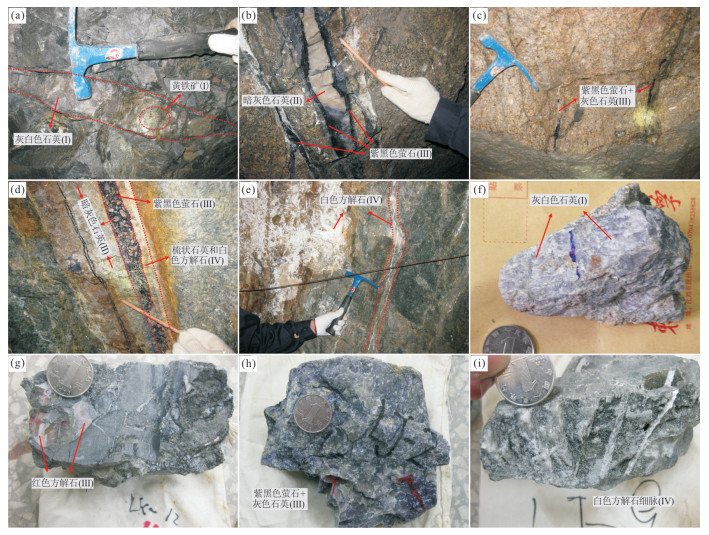
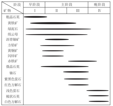
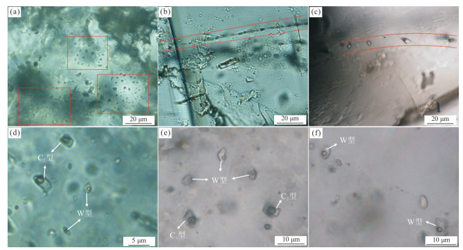
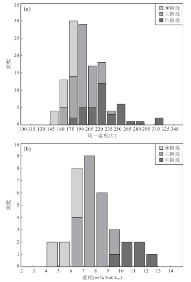
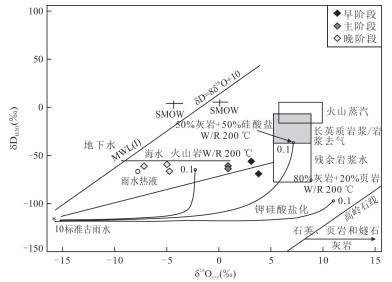
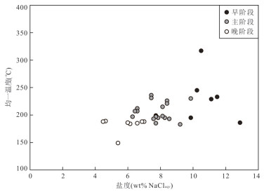
The Lujing uranium deposit located in the southwestern part of the Nanling metallogenic belt is a representative granite-related hydrothermal uranium deposit in South China. In this paperit presents new detailed fluid inclusion and H-O isotope data to constrain the source, nature, and evolution of the ore-forming fluids and reveal the ore-forming mechanism. Four stages of mineralization have been identified in the Lujing deposit: (Ⅰ) macrocrystalline quartz+pyrite+chlorite+sericite, (Ⅱ) pitchblende+sulfide+chlorite+sericite+microcrystalline quartz, (Ⅲ) purple-black fluorite+reddish calcite+microcrystalline quartz+hematite+coffinite+pyrite, and (Ⅳ) comb quartz+light-green fluorite+white calcite. The stages Ⅱ and Ⅲ represent the main uranium mineralization. The early and main stages of mineralization contain aqueous inclusions and a small amount of CO2-bearing inclusions, whereas the late stage of mineralization contains only aqueous inclusions. The fluid inclusions in early-stage quartz have homogenization temperature of 186-317 ℃ and salinities of 9.9-12.9 wt% NaCleqv. The fluid inclusions in the quartz, fluorite, and calcite forming the main stage have homogenization temperatures of 169-236 ℃ and salinities of 6.3-9.9 wt% NaCleqv. The fluid inclusions in late-stage quartz, fluorite, and calcite have homogenization temperatures of 149-189 ℃ and salinities of 4.5-7.0 wt% NaCleqv. The ore-forming fluid system evolved from a CO2-H2O-NaCl system in the early stage to a NaCl-H2O system in the late stage. Fluid boiling was the dominant mechanism for uranium precipitation. The H-O isotope results indicate that the initial ore-forming fluid is the mixture of magmatic water and meteoric water, and the meteoric water was continuously added to the ore-forming fluids during mineralization.
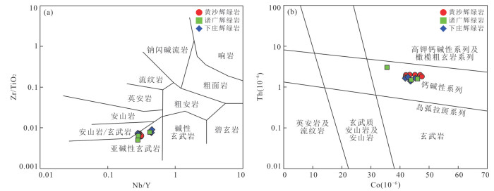
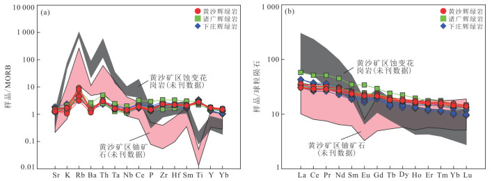
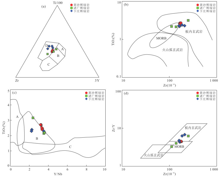
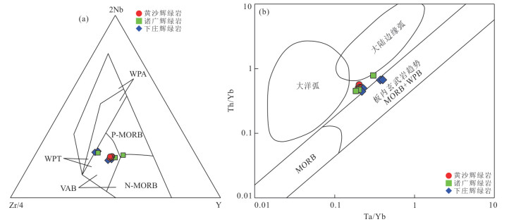
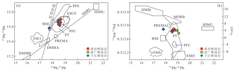
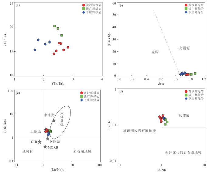
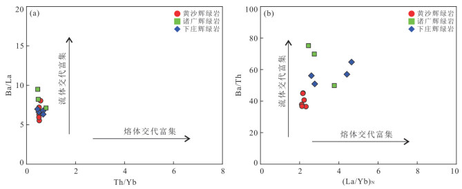
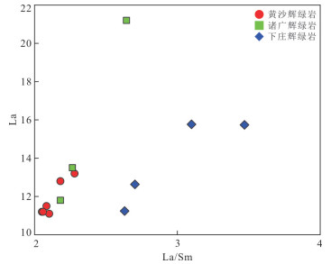
The diabase dikes in the Huangsha U ore-field of South Jiangxi Province have close spatial relationship with U mineralization. The petrography, major element, trace element and Sr-Nd-Pb isotope analysis of diabase were carried out. The diabase is geochemically characterized by low SiO2, MgO and alkaline, Na2O > K2O, enrichment of large ion lithophile elements (Sr, K, Rb, Ba), no fractionation in LREE and HREE (LREE/HREE=2.81-2.97), weak Eu negative anomaly(δEu=0.95-0.98), typical Dupal anomaly Pb isotopic, high (87Sr/86Sr)i(0.704 93-0.706 58) and low εNd(t) (3.98-4.84), suggesting that the diabase belongs to continental tholeiite series, the magmatic source was the relatively enriched mantle changed by the metasomatism fluid originated from the subduction zone of Pacific Ocean Plate, formed under the large scale lithosphere thining tectonic background. The gaps between diagenetic ages of diabase (140 Ma) and uranium mineralization ages (100 Ma, 63-76 Ma) are significantly large. It is considered that diabase provides a favorable reductive agent for pitchblende precipitation. Comparing the diabase in the Zhuguang-Xiazhuang ore-field, there are many similarities in origin and ore-controlling rules. In Huangsha U ore-field, there are favorable geological conditions for U mineralizaiton and great metallogenetic potentiality. The exploration for U deposit in the future should focus on the intersection type U mineralization and the intersection of NWW-trending basic dikes and NE-trending fracture zone.
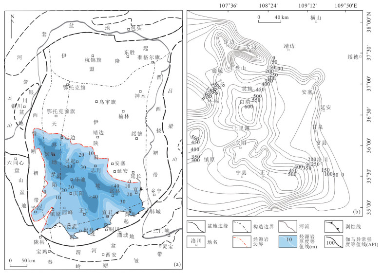
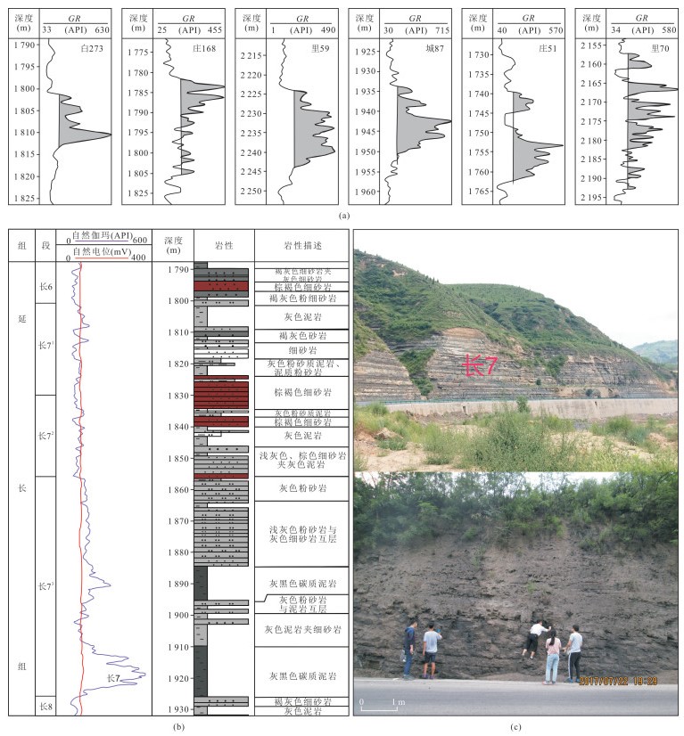
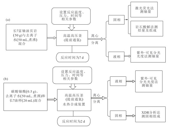
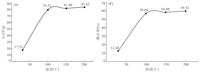
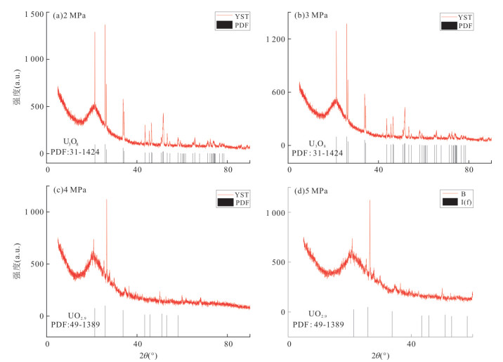
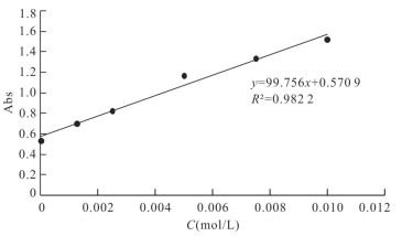
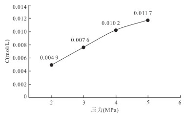
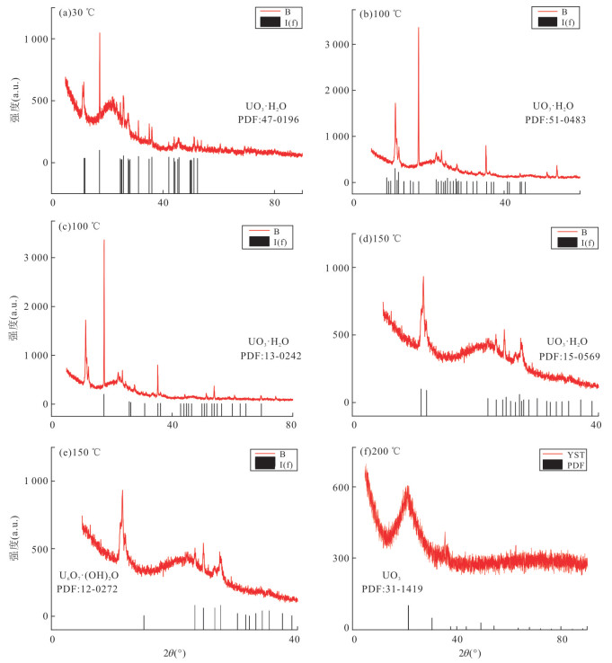
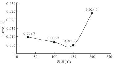
The high quality source rocks of the Chang 7 Member in Yanchang Formation of the Upper Triassic in the Ordos Basin are characterized by uranium enrichment, while the Jurassic-Cretaceous strata of the basin are famous for hosting a large number of sandstone-type uranium deposits. To analyze the possibility of source rocks providing uranium source for shallow sandstone type uranium deposits, the uranium-rich source rocks, oil samples from the Chang 7 Member and representative uranyl carbonate were selected as reactants, and simulation experiments of hydrocarbon generation and expulsion of uranium from source rocks and oil-uranium relationship were carried out respectively under the reduction conditions of medium-high temperature and high pressure. The results show that uranium can be discharged along with the process of hydrocarbon expulsion from source rock, and the increase of temperature and pressure at 30-200 ℃ and 2-5 MPa is conductive to the increase of hydrocarbon generation and uranium discharge. The discharged rate of uranium increases with the increase of hydrocarbon generation and is generally 55%-75%. Among them, the proportion of soluble uranium from itself is about 12%, and the discharged rate of uranium caused by the superposition of hydrocarbon generation is 43%-48%. The uranium migration forms found in this experiment are special, such as tetravalent (UO2), hexavalent (UO3), mixed valence (U3O8) and hydrate colloid form (UO3·H2O, U6O7(OH)2O), which are mainly adsorbed by low-temperature oil-gas fluid, and the uranium adsorption capacity shows an increasing trend with the increase of temperature and the decrease of pressure. Thus, it is beneficial for uranium ore formation when low temperature uranium-bearing oil-hydrothermal fluids migrate to shallow strata. Based on the above analyses, it is considered that the source rocks of Chang 7 Member in the southern Ordos Basin can release or discharge a large amount of uranium, which can be adsorbed by low-temperature oil-gas in the form of tetravalent, hexavalent and mixed valence. Subsequently, the adsorbed uranium moves upwards along with the oil-water fluid through the fracture, providing partial material source for the formation of shallow sandstone-type uranium deposits of the basin.

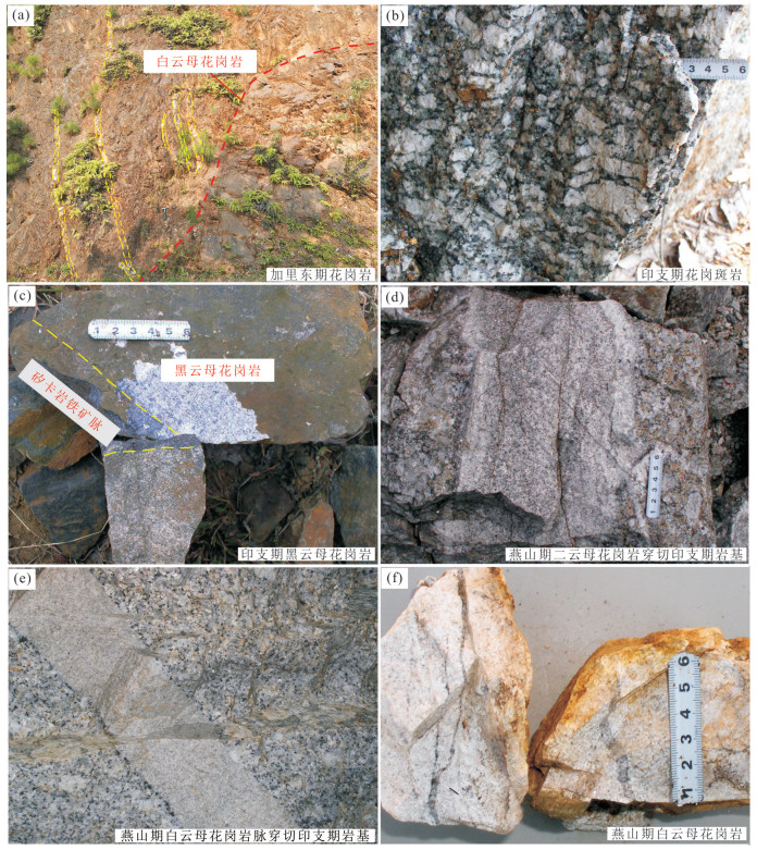
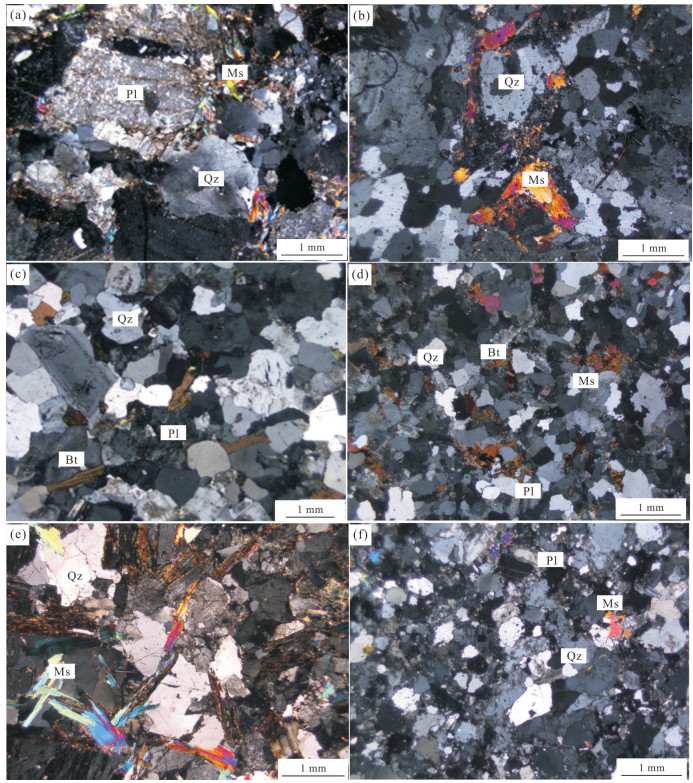
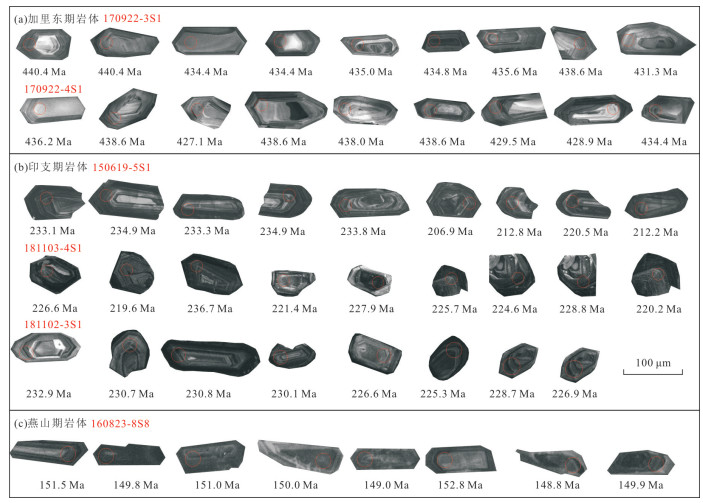
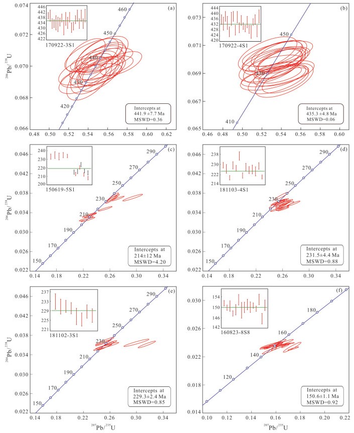
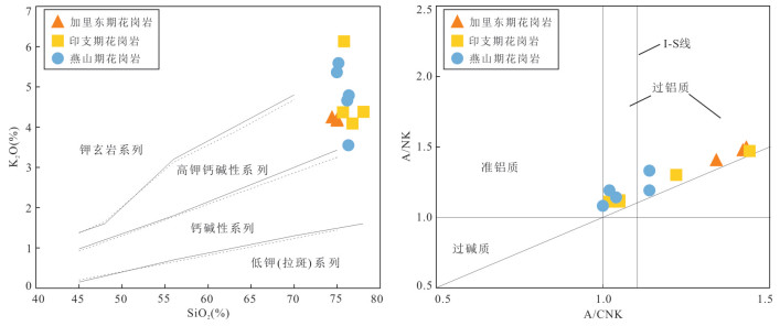
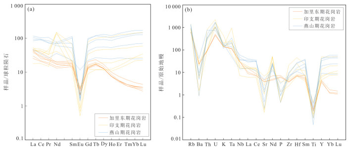
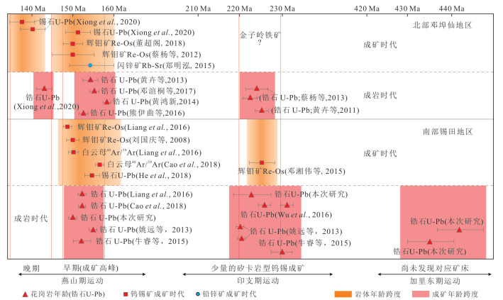
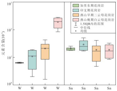
Xitian W-Sn polymetallic ore field is located in the middle part of the Nanning metallogenic belt, and multi-stage magmatism and W-Sn mineralization are developed in this ore field. To determine the spatial and temporal relationship between granites and W-Sn mineralization, in this paper it conducts field geological survey, microscopic observation, zircon U-Pb isotopic dating and geochemical analysis on the spatial distribution, lithology, intrusive age and geochemical compositions of multi-stage granites in this ore field. The results show that the Xitian ore field experienced three magmatic events, namely Caledonian (435-441 Ma), Indosinian (220-230 Ma), and Yanshanian (141-160 Ma). All of these granitoids are basically enriched in large ion lithophile elements (e.g., Rb, K, U, Th) and depleted in Ti, P, Sr, Ba, with pronounced negative Eu anomalies. The Caledonian granite and Indosinian granite are S-type granite. The Yanshanian granite is A-type granite. The metal elements in granites of different periods gradually increase from the Caledonian→Indosinian→Yanshanian, in particular, W and Sn were extremely enriched in muscovite and two-mica granites, consistent with the timing of the W-Sn flare-up in South China. A few skarn-type Fe-Cu-W polymetallic deposits were developed in the margin of Indosinian rock, and multiple quartz vein type W-Sn polymetallic deposits were developed in faults or fractures near the Yanshanian rocks, without W-Sn mineralization found near the Caledonian granites. Therefore, the multi-stage granites and W-Sn polymetallic mineralization in Xitian ore field are spatially and temporally coupled, and the major mineralization is characterized by Yanshanian skarn-type and vein W-Sn mineralization, which is an important part of Nanling mineralization belt.
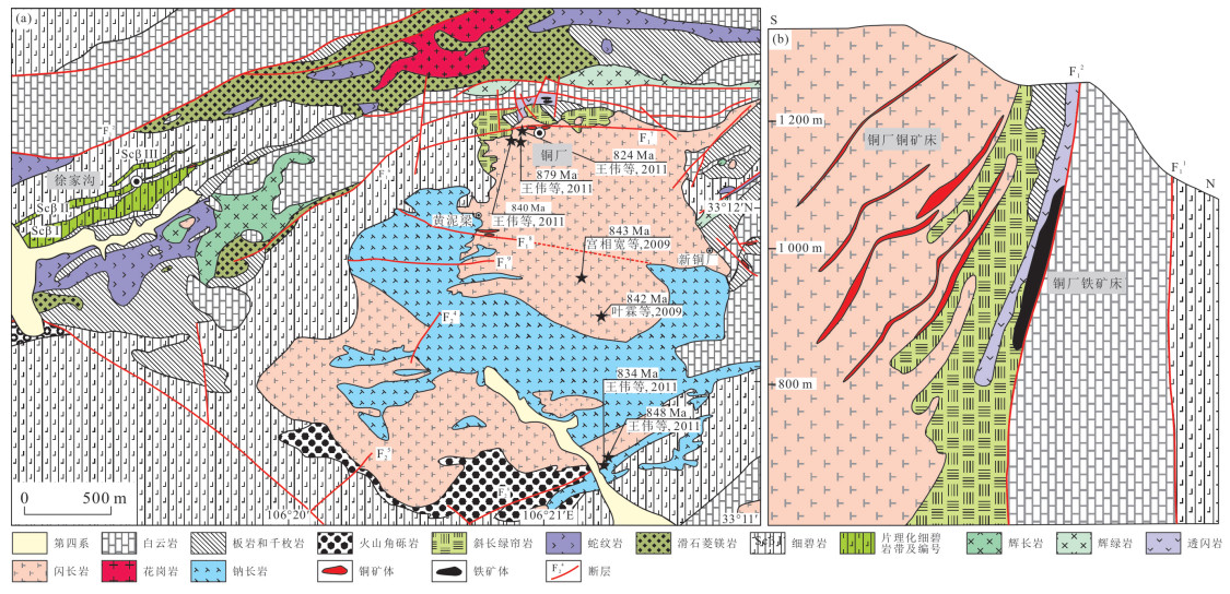
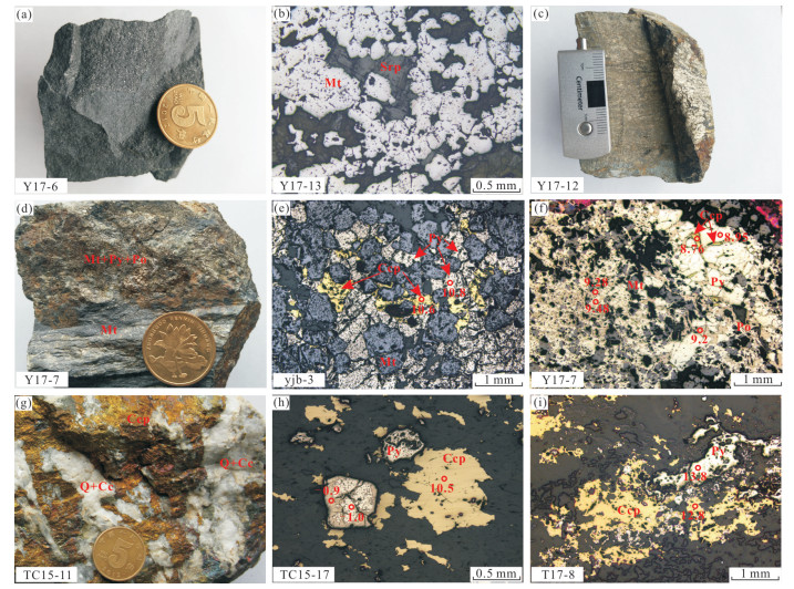
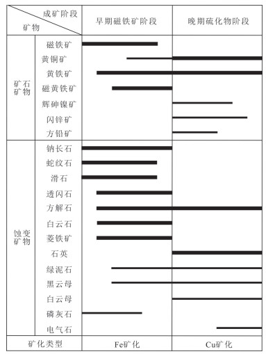
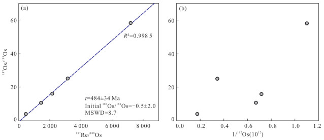
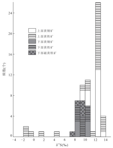
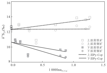
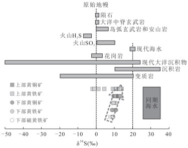
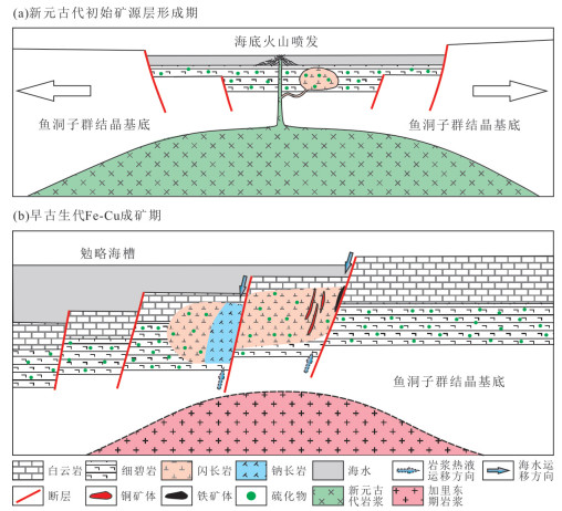
There are great disputes about the metallogenic age, source of ore-forming material and genesis of the Tongchang copper-iron deposit, which limits the establishment of its metallogenic model and further prospecting practice. Re-Os isotope of chalcopyrite is used to date the ore-forming age, and the S isotope compositions of chalcopyrite, pyrite and pyrrhotite are systematically studied by LA-MC-ICP-MS. The Re-Os isotopic isochron age of the five chalcopyrite samples is 484±34 Ma (MSWD=8.7), indicating that the Tongchang copper-iron deposit was formed in the Early Paleozoic Caledonian period. The δ34S values of chalcopyrite (+9.75‰-+13.1‰) and pyrite (+9.22‰-+13.9‰) in the upper part of Tongchang copper-iron deposit are slightly higher than those of chalcopyrite (+8.66‰-+10.9‰), pyrite (+8.85‰-+11.0‰) and pyrrhotite (+7.93‰-+9.28‰) in the lower part. The δ34S∑S value in the early ore-forming hydrothermal solution is about +10.6‰, and that in the late ore-forming hydrothermal solution is about +12.3‰, showing that the sulfur source of the deposit is from mixture of mantle sulfur and seawater sulfur. Thermochemical sulfate reduction (TSR) plays an important role in the process of seawater sulfate reduction. The formation of the Tongchang copper-iron deposit can be divided into two stages. In Neoproterozoic Jinning period, Rodinia supercontinent breakup event leads to submarine volcanic eruption and the formation of initial source bed which was enriched in Fe and Cu. During the Caledonian period of Early Paleozoic, the continuous cracking and rifting of the continental margin formed the Mian-Lue trough and led to intense magmatic activity. The magmatic hydrothermal solution enriched in volatile and sulfur, mixed with seawater sulfur, and extracted Fe, Cu and partial sulfur source from the spilite of the Guojiagou Formation. The early ore-forming hydrothermal solution formed the iron ore body in the deep part of the Tongchang area. With the precipitation of magnetite and sulfide, the ore-forming hydrothermal solution evolved to the late stage and migrated upward along the fault to form the copper deposit in the upper part of the Tongchang area.

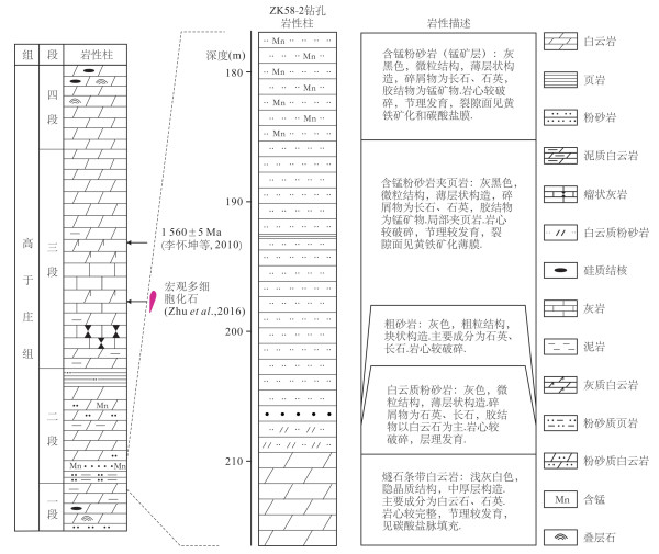
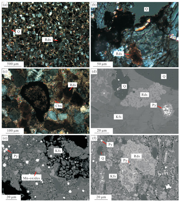
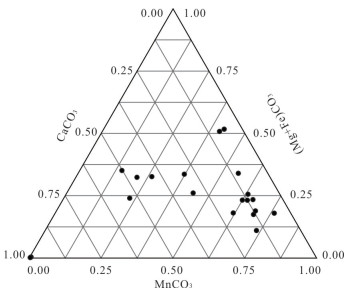
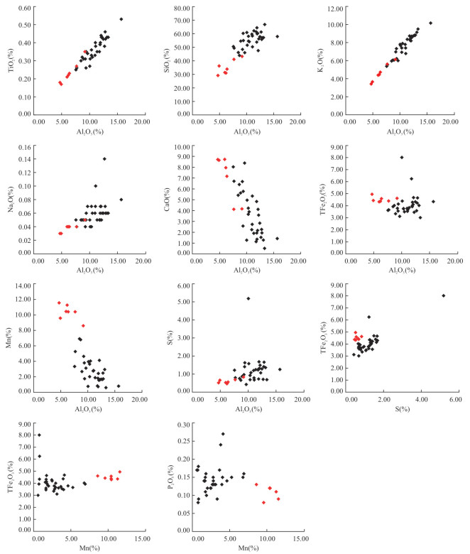
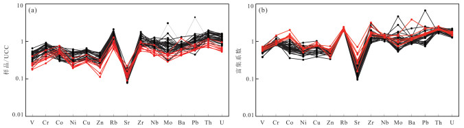
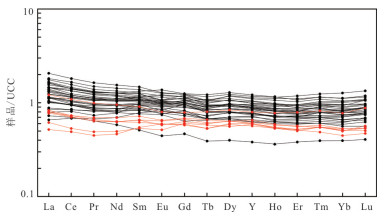
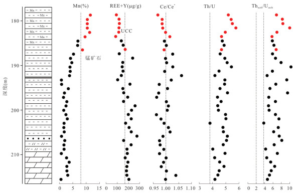
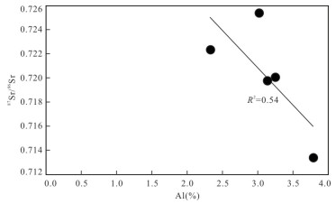
The Qinjiayu manganese ore in East Hebei occur mainly in manganese-bearing rock series at the bottom of the second member of the Mesoproterozoic Gaoyuzhuang Formation, however, the cause of manganese ore is unclear. In this paper, it uses microscopic observation, electronic microprobe analysis and whole rock geochemical analysis based on the drilling core ZK58-2 samples to provide information on the manganese sources and sedimentary environments which contribute to manganese mineralization. Microscopic examination and electronic microprobe analysis show that manganese-bearing minerals of primary ore belt samples are dominated by rhodochrosite, Fe-Mg rhodochrosite, Ca rhodochrosite and Mn calcite. Compared with based samples, the major elements of the manganese ore belt samples show low TiO2, SiO2, Al2O3, K2O and Na2O contents. Besides, all samples show negative correlation between manganese and Al2O3 contents. The trace elements of all samples show no enrichment relative to the upper crust content (UCC), except Th and U. Th/U ratios and authigenic Th/U ratios have similar stratigraphical tendency, with low Fe/Mn ratios, indicating that paleo-ocean environment was dominated by oxic-suboxic conditions. UCC-normalized REE+Y patterns are flat, showing no Ce anomaly (Ce/Ce*=1.00±0.02, n=39) and low Y/Ho ratios. Initial 87Sr/86Sr ratios of Mn ore belt are between 0.713 383 and 0.725 378, having an average value of 0.720 180, showing a negative correlation with Al2O3 contents. Comprehensive sedimentary and geochemical analyses show that Mn sourced from both hydrothermal fluids and continental weathering input. Manganese sources, combined with paleo-ocean oxidation and sea level fluctuations, controlled the Gaoyuzhuang manganese ore.
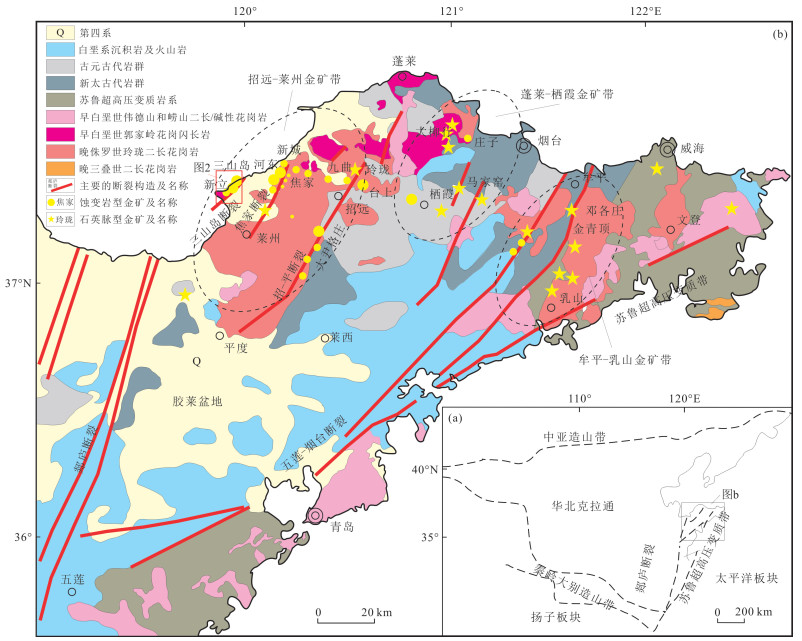
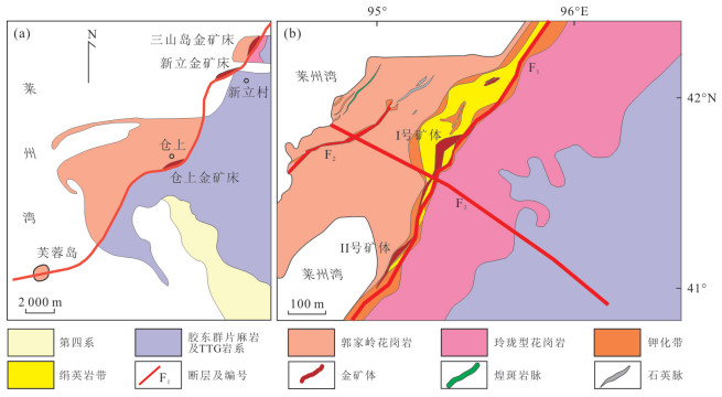
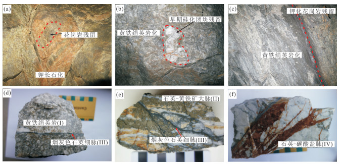
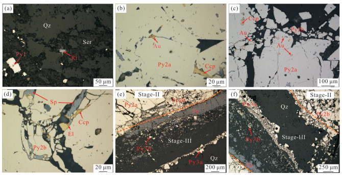
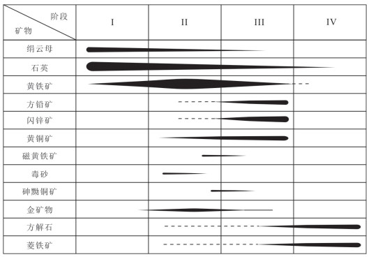
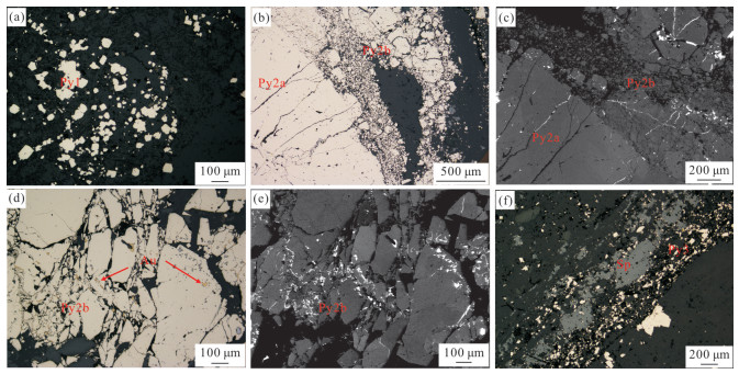
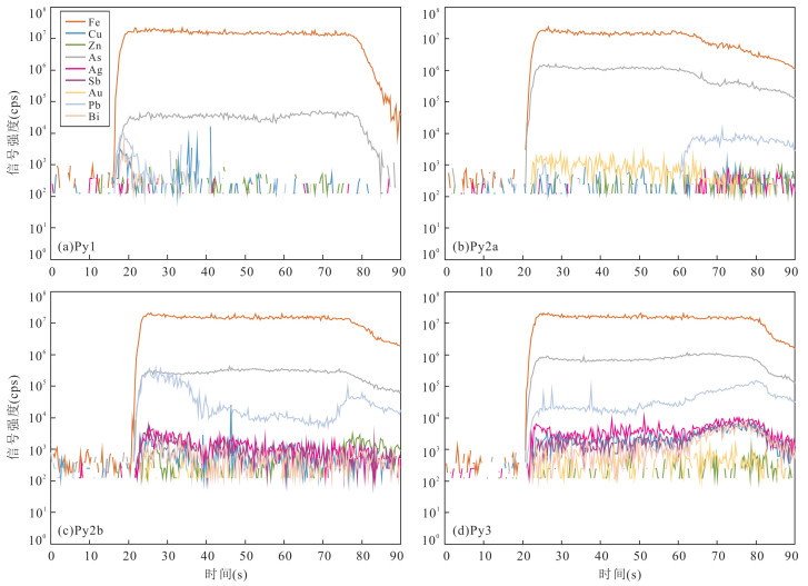
The Sanshandao gold deposit, located in the northwest of Jiaodong district, is a super-large altered-rock type gold deposit. The lack of detailed studies of mineralogy and element geochemistry in this deposit limits the understanding of Au enrichment mechanism and process. Based on field work and mineralogical observation in the deposit, the Au mineralization is divided into four stages: the quartz-sericite-pyrite stage (Ⅰ), quartz-gold-pyrite stage (Ⅱ), quartz-gold-polymetallic sulfide stage (Ⅲ) and carbonate-quartz stage (Ⅳ). The main gold-bearing mineral is pyrite. Py1 in stage Ⅰ is characterized by euhedral grains with no deformation and low contents of As and Au. In stage Ⅱ, the Py2 can be divided into two sub-generations: coarse Py2a with no deformation and Py2b with massive plastic and brittle deformation. The contents of Au and As are high in Py2a and low in Py2b.In stage Ⅲ, the Py3 includes fine-grained euhedral Py3a coexisting with quartz and Py3b coexisting with polymetallic sulfide, both with weak deformation and medium Au and As contents. In-situ trace element analysis of pyrite indicates Co, Ni and Ag entering pyrite lattice by forming solid solution, whereas Pb, Zn and Cu mainly presenting as sulfide inclusions. The main occurrence state of gold is visible Au that occurs in the cracks and intergranular space of pyrite as electrum. The invisible Au in pyrite is lattice gold, and its enrichment is closely related to As. To be specific, As- replacing S- entered into pyrite, resulting in lattice distortion of pyrite, which prompted the Au+ into the pyrite lattice. The decompression boiling of ore-forming fluids in stage Ⅱ resulted in Au precipitation and intergrowth with Py2a as visible inclusions and intergranular gold. The plastic deformation of Py2b in stage Ⅱ induced by syn-activation of ore-controlling fault, such as dislocation creep, lattice rotation, promoted the formation of intracrystalline "fast pathways", and further remobilized invisible Au through intragrain diffusion or fluid-mediated liberation. The remobilized Au re-concentrated as visible gold in microfractures and boundaries of pyrite grains, which contributes to the formation of high-grade gold ores in Sanshandao.


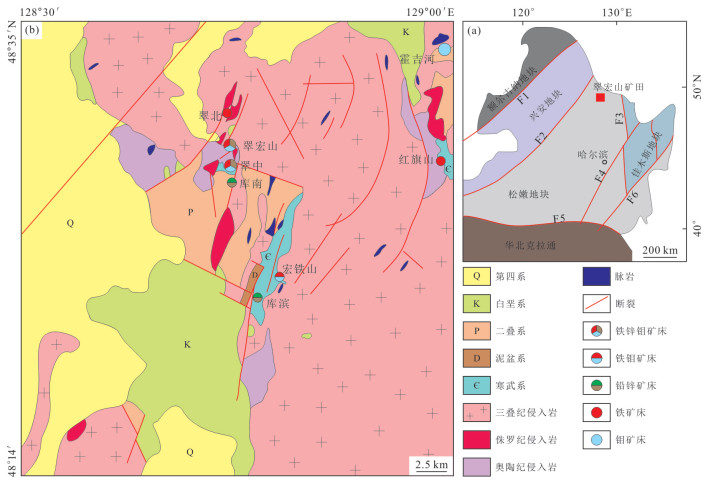
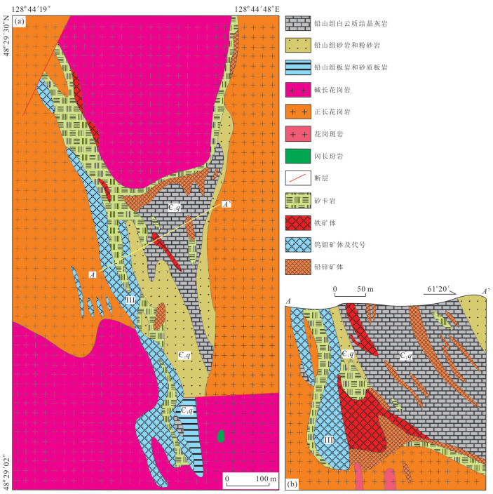
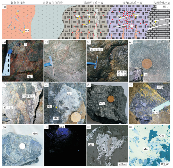
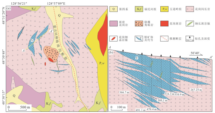
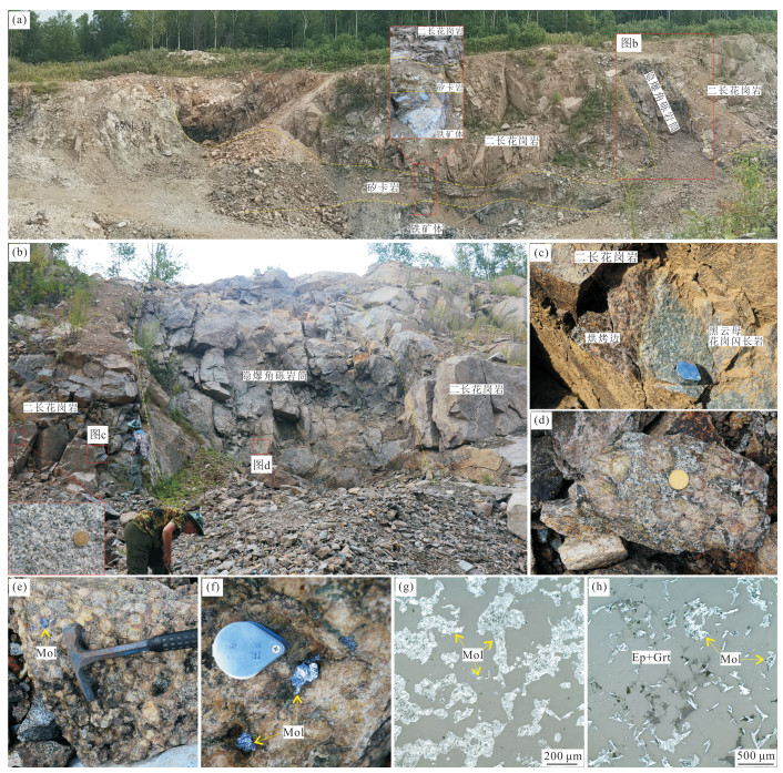
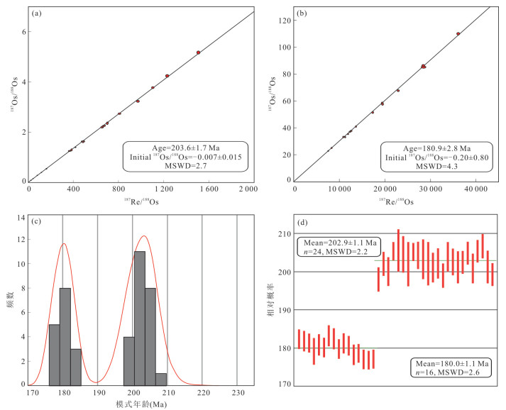
Cuihongshan Fe-Mo-polymetallic ore field in Heilongjiang Province belongs to the Lesser Xing'an Range-Zhangguangcailing Fe-polymetallic metallogenic belt, and is characterized by the large-scale mineralization of Fe, Pb, Zn, Mo and W. Among them, Mo mineralization is the most noticeable, with three mineralization styles, including skarn-porphyry Mo-W, porphyry Mo-only, and cryptoexplosion breccias Mo, coexisting in a single ore field. However, the mineralization characteristics and spatio-temporal relationship of the three Mo mineralization types have not been systematically analyzed, and the Mo mineralization events have not been clearly defined. In this paper, the Cuihongshan, Huojihe and Hongtieshan Mo (polymetallic) deposits were selected for the geological characteristics analyses. Combining the geological characteristics with molybdenite Re-Os dating, two Mo mineralization events in Cuihongshan ore field were defined, including the Late Triassic skarn-porphyry Mo-Wand cryptoexplosion Mo mineralization and the Early Jurassic porphyry Mo-only mineralization. The Re content of molybdenite and petrogenesis of ore-forming magma reveal that Mo in Cuihongshan ore field were derived from a mixed source containing mantle-derived juvenile materials and ancient crustal components. And compared with the Late Triassic mineralization, more mantle-derived juvenile materials were involved during the Early Jurassic mineralization. Based on the mineralization characteristics and ore-forming material source analysis, the Mo mineralization is suggested to be related to the collision process between Songnen block and Jiamusi block during Late Triassic to Early Jurassic.

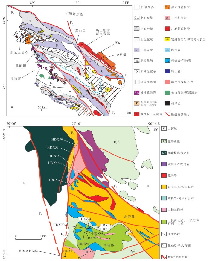
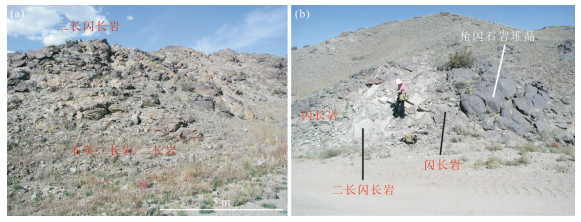
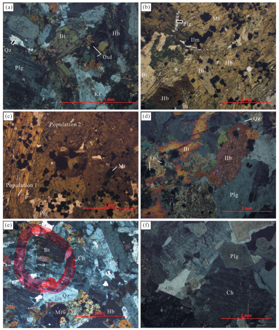
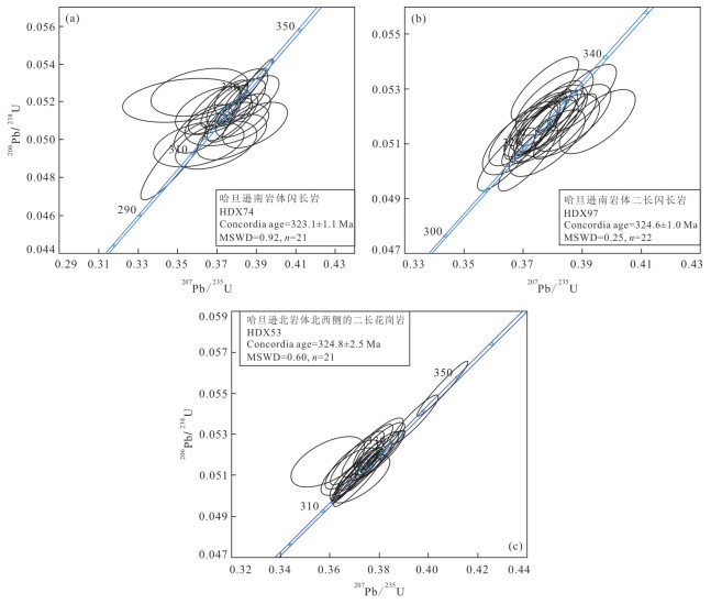
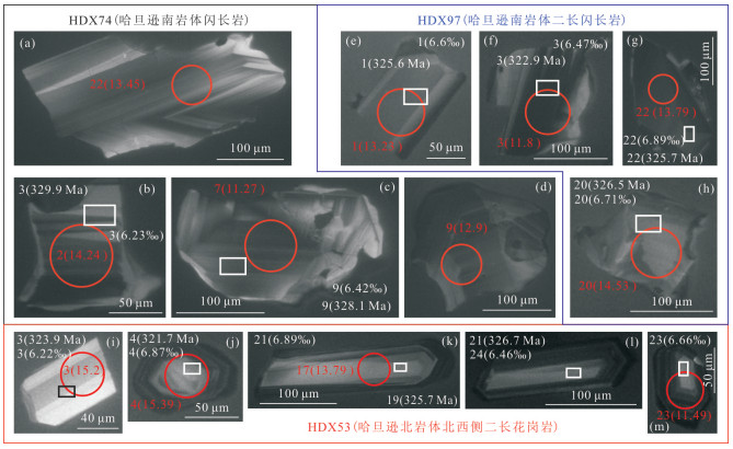
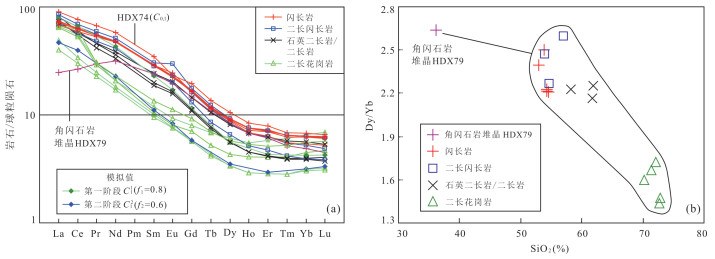
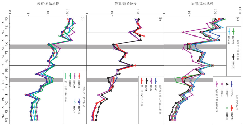
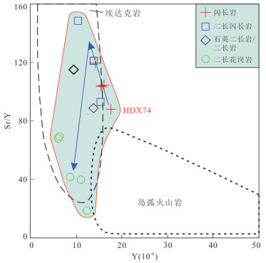
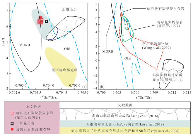
Secondary-ion mass spectrometric U-Pb age (324.8-323.1 Ma) and δ18O and laser-ablation multi-collector ICP-MS εHf(t) of zircons, mineral chemistry and whole-rock geochemistry and Nd-Sr isotopes of the Carboniferous intrusive complex of Hadanxun were analyzed in this study in order to expound the mechanism of arc magma generation and decipher high P-wave velocity body in the middle crust of Northeast Junggar. Their rare earth element distribution patterns are concave-up. The major and trace element variations from diorite (with entrained hornblendite cumulate) to monzogranite, with decreasing Dy/Yb and primitive-mantle normalized NbN/TaN, can be reproduced with quantitative modeling of fractional crystallization of hornblendite (Stage 1) and feldspar-dominated minerals (Stage 2). They exhibit high Sr/Y, low Y and mean zircon δ18O of 6.42‰, suggesting derivation from subducting oceanic-slab. Al-in-hornblende barometer reveals that the hornblendite cumulate (population 1: 26-22 km depth; population 2: 20-18 km) constitutes high P-wave velocity body in the middle crust of Northeast Junggar. The Carboniferous intrusive complex of Hadanxun exhibits high positive zircon εHf(t) (weighted mean=12.99) and depleted εNd(t) (6.22-6.55) and (87Sr/86Sr)i (0.703 7-0.704 0), precluding oceanic crust and continental-crustal materials from Chinese Altay as source component. Thus, the Northeast Junggar was an intra-oceanic arc and the oceanic-plate subduction continued until the Carboniferous.

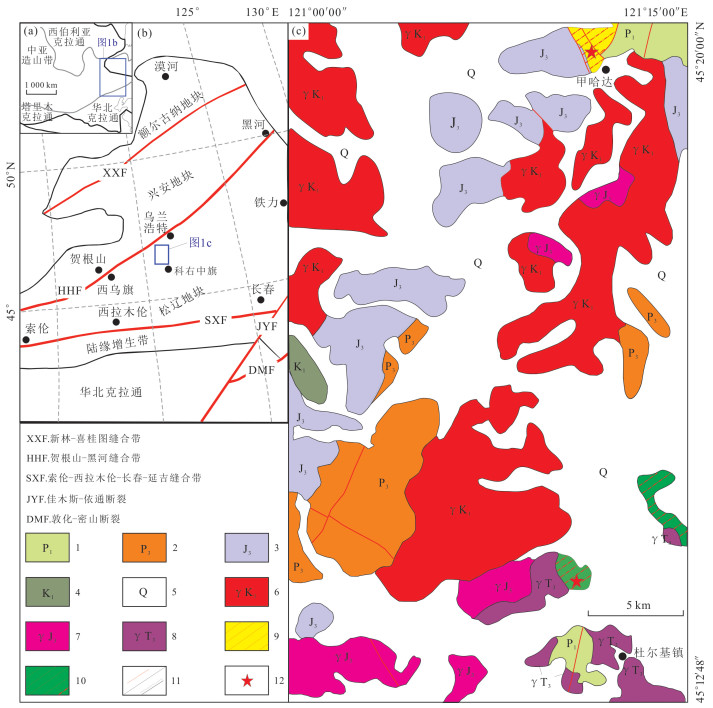
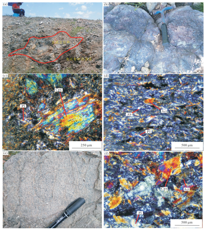
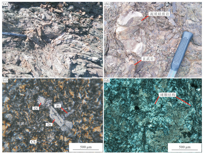
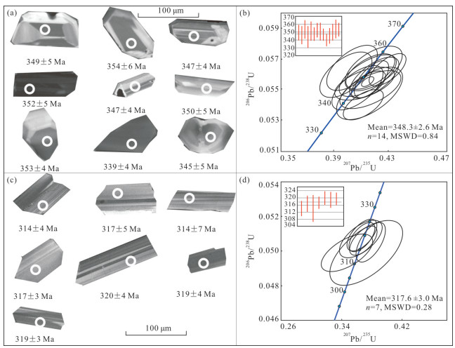
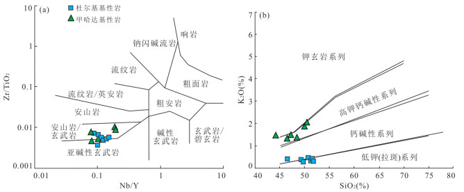
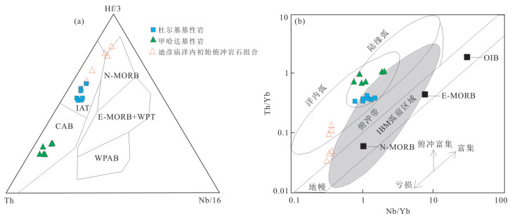
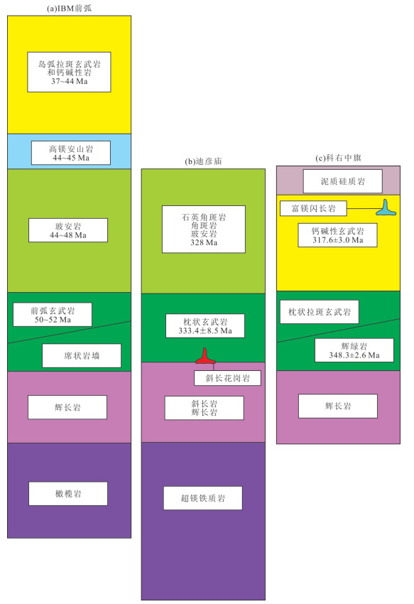
The Late Paleozoic tectonic evolution in the eastern Xing-Meng orogenic belt is controversial, and the basic magmatism is a good geological record in the process of tectonic evolution. In this paper, the geological features, petrography, geochronology and geochemistry of the two newly identified basic rocks (Duerji basic rocks and Jiahada basic rocks) in the Horqin Right Middle Banner area of Inner Mongolia, eastern Hegenshan suture zone, are systematically studied. Both types of mafic rocks are structurally located in the tectonic melange zone. The Duerji mafic rocks are pillow basalt and diabase, and LA-ICP-MS U-Pb of zircon from diabase is 348.3±2.6 Ma. They are tholeiites and their geochemistry is characterized by low Ti and high Mg. LILE is relatively enriched and HFSE is relatively depleted. The mafic rocks in Jiahada are basalts, and the zircon U-Pb age is 317.6±3.0 Ma. The geochemistry is calc-alkaline series, and they are characterized by HFSE depletion and LILE enrichment compared with the Duerji mafic rocks. They are more abundant in LILE and LREE. Based on the research results of Early Carboniferous ophiolites and intracontinental subduction in Hegenshan suture zone, the evolution from Duerji mafic rocks to Jiahada mafic rocks may indicate the progressive process of Early-Late Carboniferous intra-oceanic subduction in the eastern part of the Paleo-Asian Ocean, characterized by the evolution of intra-oceanic arc from immature to mature.

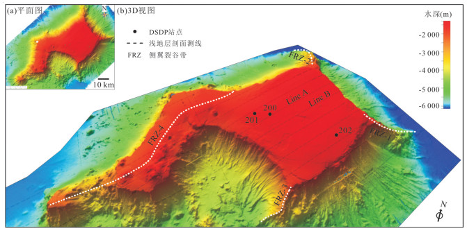
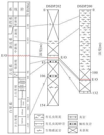
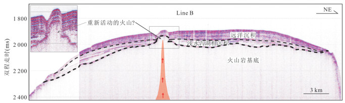
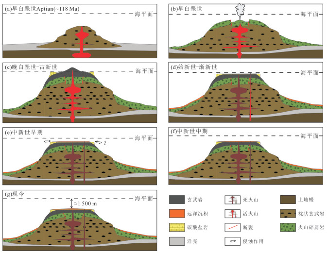
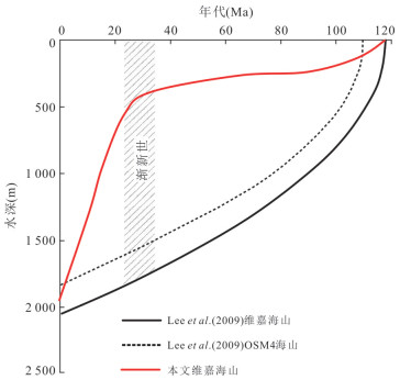
Sedimentary processes of seamounts are closely related to global paleoclimate change and paleoceanography evolution. The Weijia Guyot retained the complete sedimentary records since the Late Mesozoic, which made Weijia Guyot an ideal area for tectonic evolution studies of seamounts in the western Pacific Ocean. Based on the results from sub-bottom profiling, ocean drilling, and the latest research, in this paper it explores the sedimentary process of Weijia Guyot since Late Mesozoic by studying the sedimentary characteristics, volcanic activity and subsidence rate of the seamount. There are three sedimentary units on the summit of Weijia Guyot. Direct evidence of rejuvenated volcanism during Eocene is found in this paper, and deposition rate of Weijia Guyot is determined as approximately 6.03 mm/ka since Middle Miocene (~11.6 Ma). The evolution model of Weijia Guyot is established for the first time, which is being divided into seven main phases. New perspective about the subsidence rate of Weijia Guyot is revealed: the subsidence rate was low before Oligocene, and the water depth at the summit ranged within hundreds of meters; subsequently, the subsidence speeded up during Early Miocene (~20 Ma) after an inflection point, and it may be related to the rapid change of the direction of the Pacific plate movement during this period.

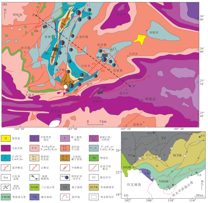
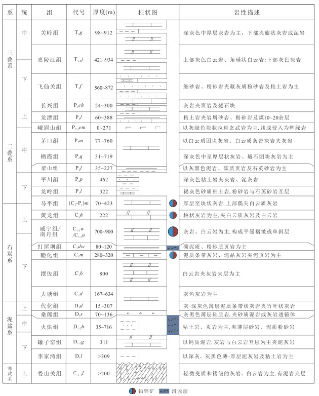
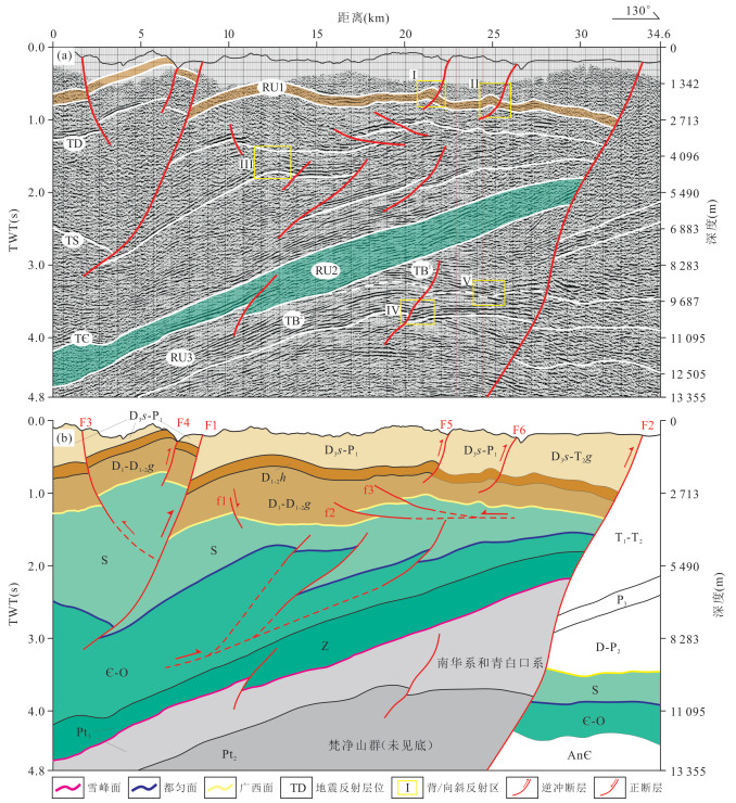
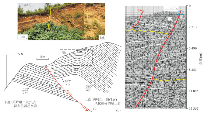
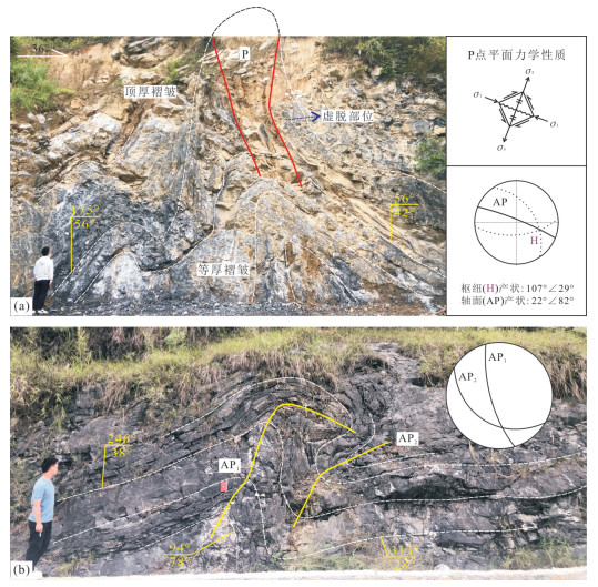
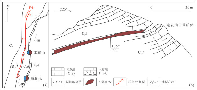
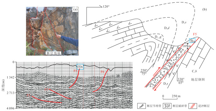
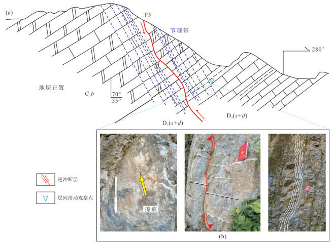
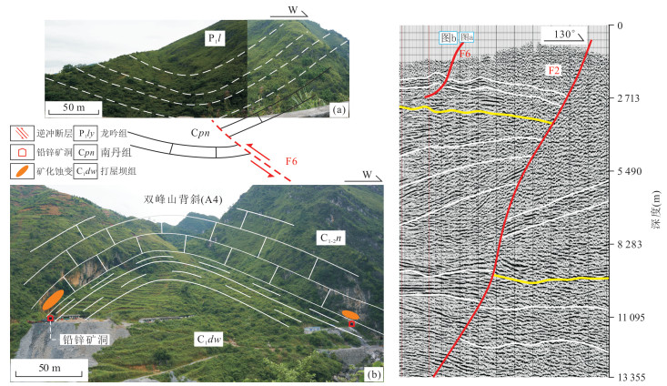
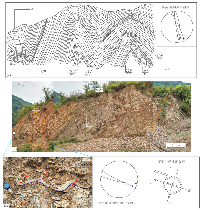
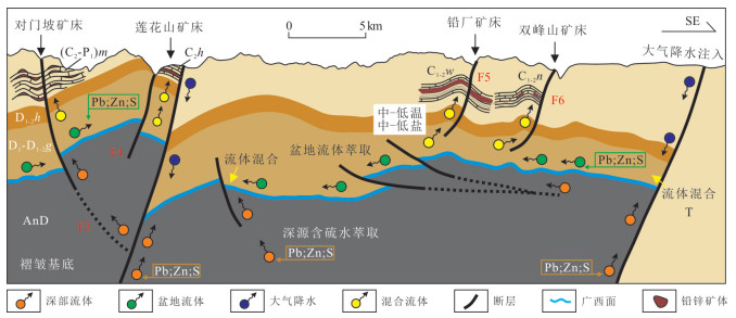
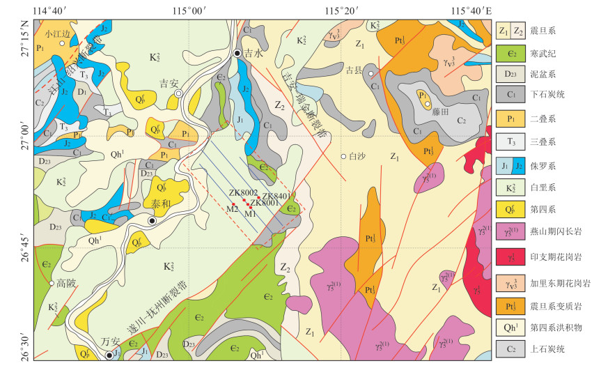
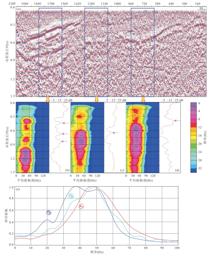
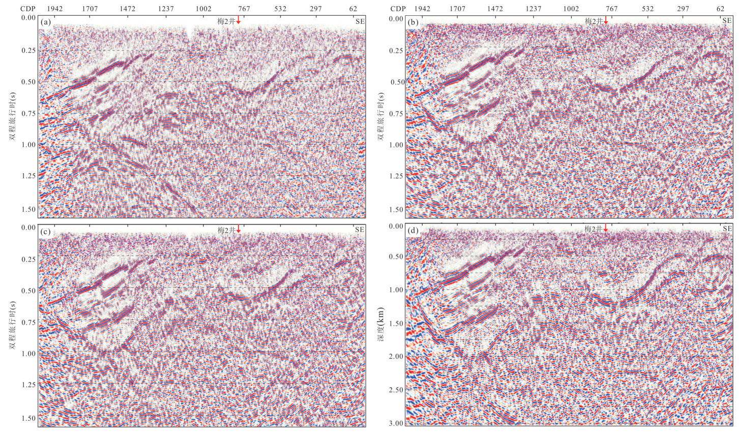
Pu'an Pb-Zn deposit area in Guizhou Province is situated in the Southwest Guizhou Depression on the northwest edge of South China fold belt. The ore bodies occur in the Carboniferous dolomitic limestone and dolomite, with significant characteristics of structural ore-control. Two-dimension (2D) seismic profile of the NW-SE striking passes through the Pb-Zn mine area, clearly revealing the stratum and NE-SW trending structural framework of the research area. From the shallow Devonian to the deep Neoproterozoic, a total of 3 seismic reflectors and 3 reflecting units are labeled. Based on recognition of two crucial surfaces of angular unconformity, the "2+1" basin stratigraphic framework consisting of double basement and single sedimentary cover is clearly represented, which provides new evidence for the tectonic attribute of Southwest Guizhou. The basin structural framework in the mining area is composed of two controlling thrust faults with secondary reverse faults and folds. Field observation and structural analysis of the fault outcrops and its secondary structures shown in the seismic profile were conducted, moreover the ore-controlling faults of 4 deposits were dissected. It is proposed that the Indosinian compressional deformation would be related to the ore-forming age. Based on the structural framework of the seismic interpretation, the role of each structural factor is detailed analysis in the mineralization process. The two deep-cut basement faults (first-order fault) would be fluid migration channels from atmospheric water and deep basin. The Guangxi unconformity would act as a lateral migration pathway. The thin-skin faults that cut across the Lower-Middle Devonian Huohong Formation (aquifuge) acted as a vertical migration conduit for ore-forming liquid to upward-rise to the Carboniferous mineralization. Combined with the structural ore-controlling characteristics of representative deposits, a model of basin-scale structural ore-controlling of the Pu'an lead-zinc study area was established.