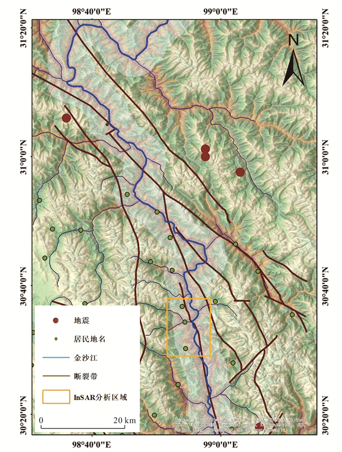
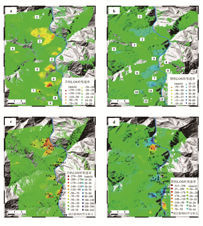
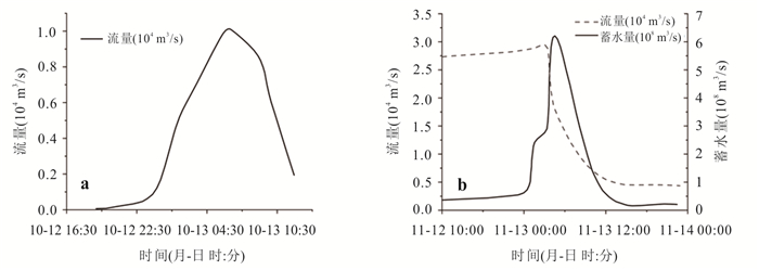
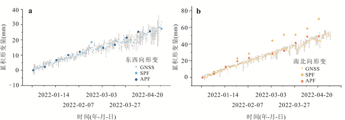
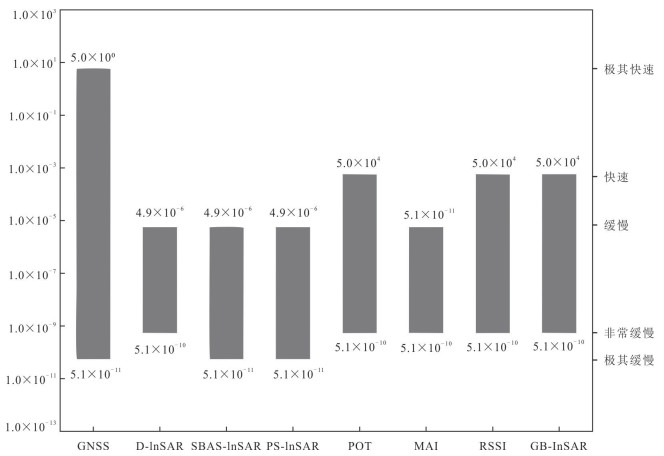
This study employs the SBAS-InSAR technique to process Sentinel-1A ascending and descending orbit SAR data from 2014 to 2022, focusing on the impact of the Baige landslide-induced river damming event on the activity of the nearest downstream landslide cluster. The Shadong landslide, which was significantly affected by the damming, was selected for terrain-constrained three-dimensional (3D) deformation inversion using InSAR, with GNSS observations used to validate model performance. Results indicate that, following the damming event, deformation rates of the riverside landslides generally increased by a factor of 3 to 7. In particular, the Shadong landslide, located on the concave bank of the Jinsha River, exhibited a notably impacted area of approximately 1.85 km2, with the maximum deformation rate increasing up to 7 times compared to the pre-damming period. The 3D deformation analysis demonstrates that the Aspect-Parallel Flow (APF) terrain-constrained model outperforms the Surface-Parallel Flow (SPF) model in reconstructing the deformation pattern of the Shadong landslide.
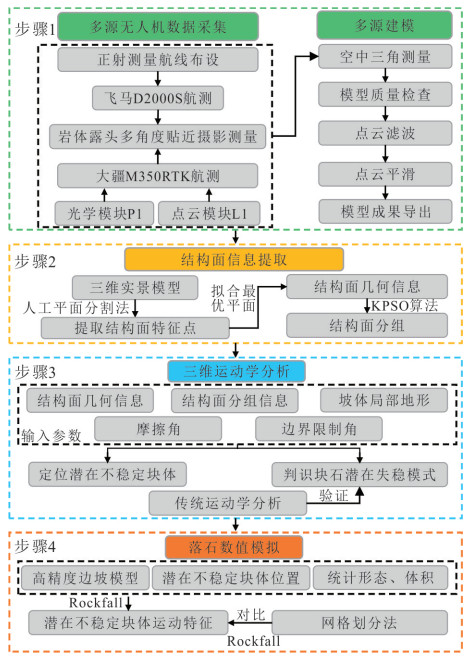
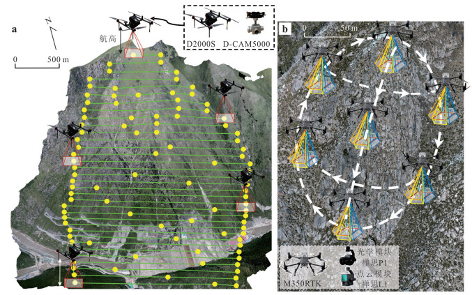
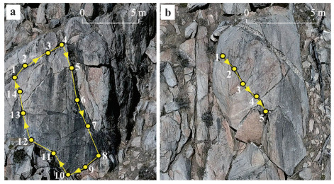
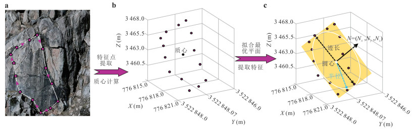
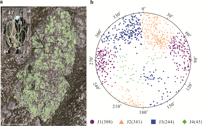
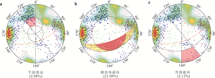
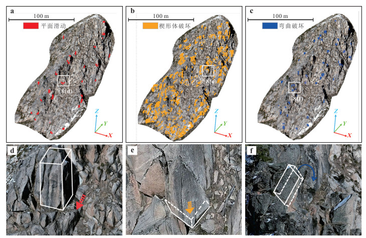
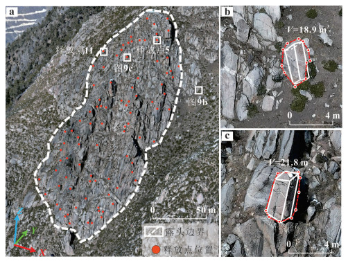
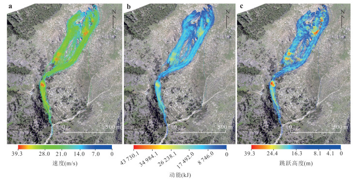
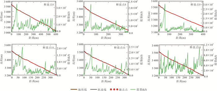
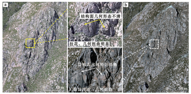
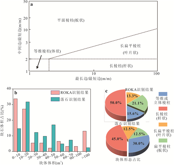
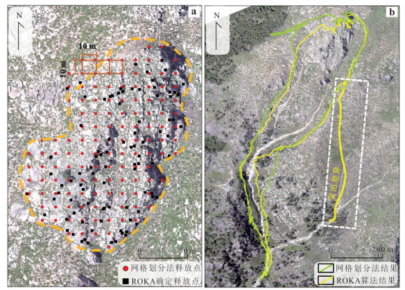
To address the bottlenecks encountered in major engineering works in mountainous regions namely, the difficulty of spatially locating potentially unstable blocks on high and steep rock slope and the insufficiency of quantitative analyses of associated hazard effects, this study proposes an integrated analytical framework combining unmanned aerial vehicle (UAV) photogrammetry, discontinuity interpretation algorithms, three dimensional (3D) kinematic analysis, and rockfall numerical simulation to identify and locate high-elevation potentially unstable blocks, determine their failure modes, and analyze associated hazard effects. Taking the high-elevation rock outcrop on the left bank of the Shuangjiangkou hydropower station dam site on the Dadu River as an example, the framework effectively identified 92 potentially unstable blocks and determined that wedge failure is the primary instability mode. The simulated 3D rockfall trajectories show that, after destabilization, the blocks exhibit cyclic acceleration-deceleration trends, with a maximum runout distance of 845.6 m, posing minimal impact on the hydropower hub area. In addition, this study emphasizes the importance of precise spatial localization of unstable blocks for improving rockfall hazard risk prediction accuracy, which has important implications for rockfall disaster prevention and control.
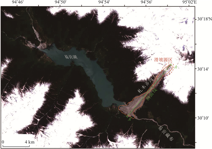
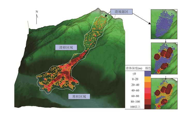
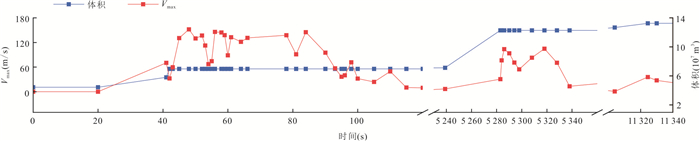
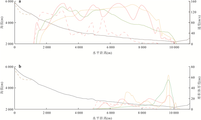
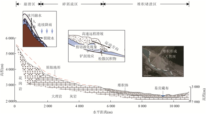
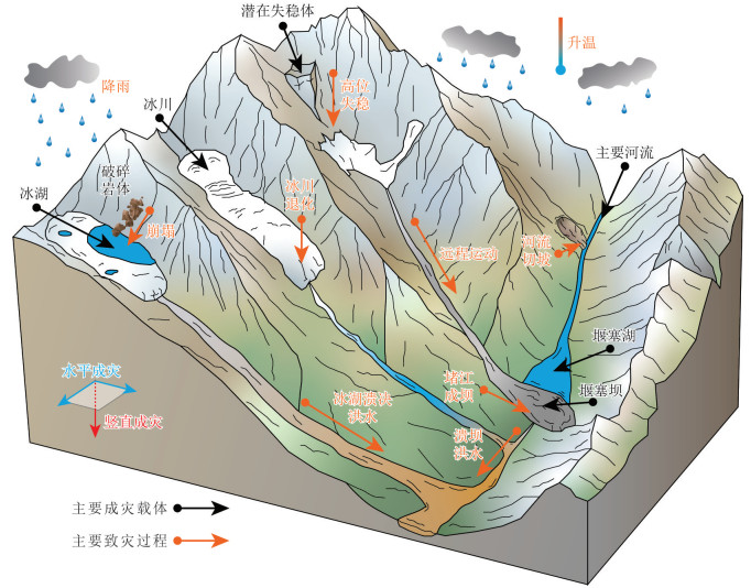
High-speed long-distance landslides exhibit complex disaster patterns and diverse triggering factors, making the determination of their initiation mechanisms and dynamic evolution stages a key research focus and challenge. This study takes the Yigong high-speed long-distance landslide as an example and integrates static inversion with dynamic simulation to reveal the triggering mechanism and movement characteristics of the landslide under the combined influence of glacial meltwater and rainfall. Based on remote sensing images, ring shear tests, and digital elevation models, key parameters (pore pressure coefficient) were calibrated using the limit equilibrium method, and a loose accumulation layer was preset along the sliding path to quantitatively characterize shear liquefaction and the scraping effect. The results show that rainfall and glacial meltwater significantly increase pore water pressure and reduce shear strength, leading to landslide instability. Furthermore, shear liquefaction and the scraping effect during motion increased the sliding speed by 32.1% and expanded the landslide scale by 28.3%. The simulation results agree well with actual conditions, providing a scientific basis and methodology for risk prevention and control of similar geological disasters.
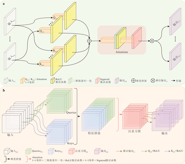
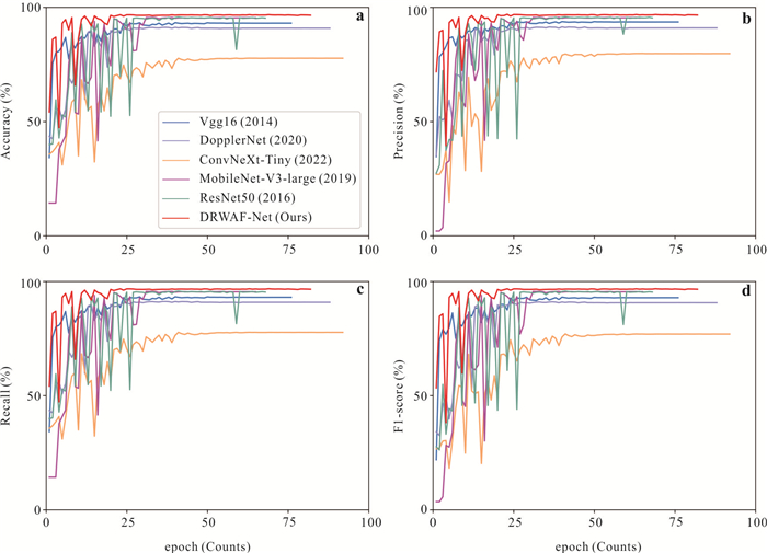
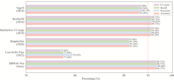
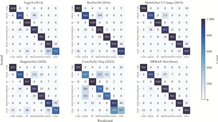
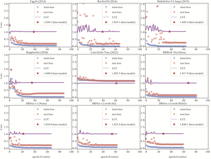
To address the demands for high-accuracy and real-time identification of sudden geological hazards, a lightweight multi-scale feature fusion network for Doppler radar, termed DRWAF-Net (doppler radar Wavelet Attention Fuse Network), is proposed. By jointly integrating wavelet transform and attention mechanisms, the proposed method enables real-time recognition of debris flows, rockfalls, and other hazard targets under complex surface conditions. The study fully exploits the capability of Doppler radar to dynamically capture the range and velocity characteristics of moving hazard bodies, and constructs a Doppler radar dataset for sudden geological hazard scenarios by integrating key elements from a debris flow dataset under environmental interference and the RDRD dataset. Experimental results show that DRWAF-Net achieves superior performance on the test set with only 2.38 M parameters, a model size of 9.27 MB, and an inference time of 6.31 ms, attaining an accuracy of 96.77%, precision of 96.90%, recall of 96.77%, and an F1-score of 96.77%. Ablation experiments further demonstrate that the introduction of a multi-input attention gating (MIAG) mechanism improves recognition accuracy by 1.87%-3.13% compared with baseline models. Owing to its lightweight design and real-time inference capability, the proposed approach provides an effective and intelligent monitoring solution for emergency response to sudden geological hazards.
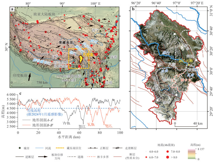
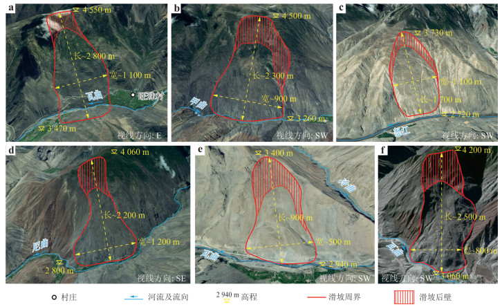
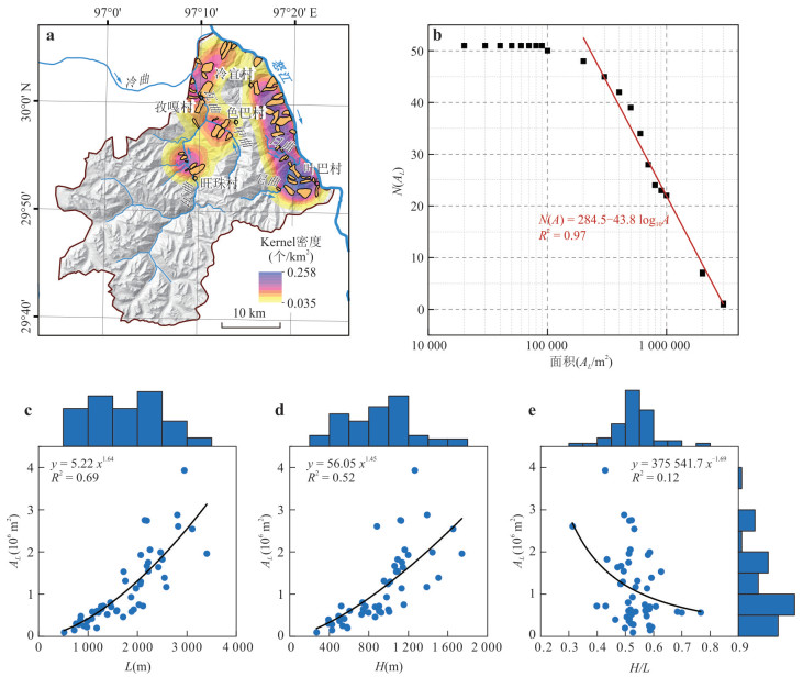
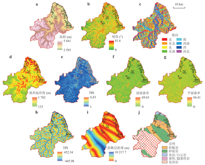
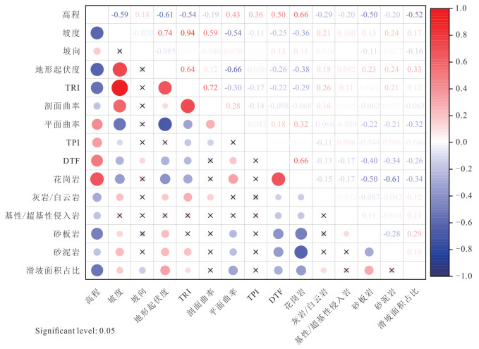
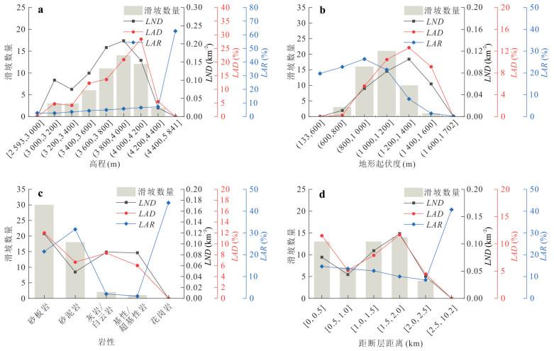
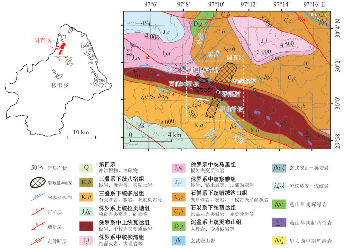
Southeast Tibet, located at the southeastern margin of the Qinghai-Tibet Plateau, is characterized by active plate tectonics and intense topographic relief, making it a high-incidence area for large high-position landslides. To investigate the forming mechanisms of large high-position landslides in Southeast Tibet, ancient landslides in Linka Township, Basu County, were identified through remote sensing interpretation to establish a landslide inventory. GIS-based spatial analysis and statistical methods were then applied to characterize their spatial distribution and determine the dominant controlling factors. Finally, four representative high-position ancient landslides near Ziga Village were selected for field investigation to further examine their forming mechanisms. Remote sensing interpretation identifies 51 high-position ancient landslides, all located on deeply incised valley flanks, primarily concentrated along the slopes of the Nujiang and Waqu rivers. Statistical analysis reveals that lithology and topographic relief are the primary environmental controls on their distribution. Ancient landslides are most likely to develop in sandstone-slate strata and in areas with relief between 1 000 and 1 600 m. Field investigations of four typical ancient landslides near Ziga Village in Linka Township reveal that they all developed in fragmented rock masses induced by long-term flexural toppling. The widespread occurrence of moderately to steeply dipping, layered, weakly metamorphosed sandstone and slate—typical topple-prone rock masses—in the landslide areas of Linka Township, combined with the sliding directions of ancient landslides generally aligning with or opposing the dominant bedding orientation, suggests that toppling was likely a widespread pre-existing failure mechanism prior to the formation of these ancient landslides.
Southeast Tibet Plateau is characterized by active endogenic and exogenic processes, which result in the temporal multi-phase occurrence and spatially cascading nature of geohazards, leading to frequent and severe disastrous events. Focusing on the influence patterns of endogenic and exogenic forces on the occurrence of geohazards in Southeast Tibet Plateau, in this paper it summarized the hazard-prone environmental characteristics shaped by these dynamics. It identified endogenic processes—such as fault activity and earthquakes—as key drivers of long-term geohazard incubation, while exogenic processes—such as climate and river dynamics—serve as short-term triggering factors. The study highlighted the dominant role of endogenic dynamics at large spatial and temporal scales and the triggering role of exogenic dynamics at small scales. A systematic spatiotemporal analysis framework for geohazards in Southeast Tibet Plateau was proposed, which outlined the characteristics of geohazards across scales and synthesizes the multi-scale influence patterns of endogenic and exogenic dynamics. This framework established the linkage between the spatiotemporal features of regional geohazards and the controlling dynamic processes. Building on the current state of research, the study outlined future scopes for quantitatively assessing the influence of endogenic and exogenic dynamics on geohazards in Southeast Tibet Plateau. Ultimately, it aims to clarify the linkage patterns between geohazards and dynamic factors, thereby contributing to more precise disaster prevention, stronger support for strategic infrastructure, and more effective adaptation to the climate change in the region.
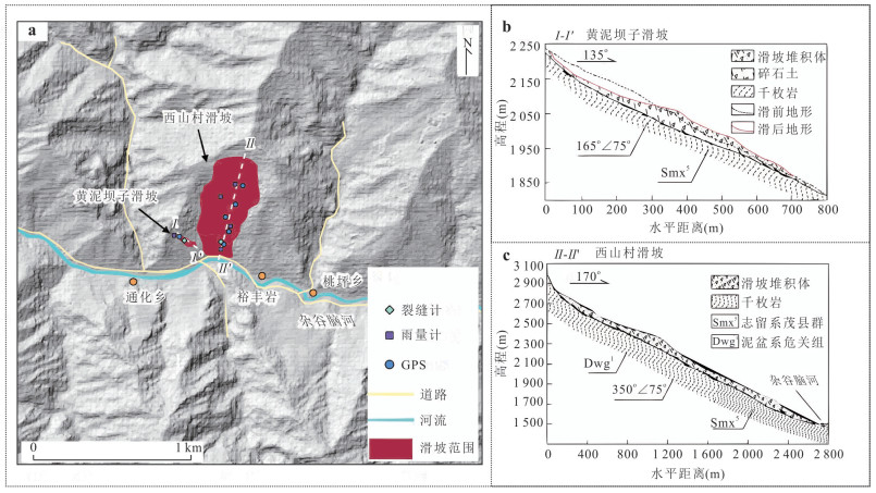
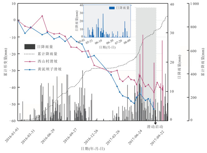
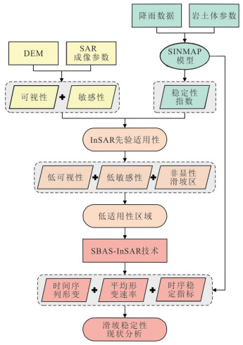
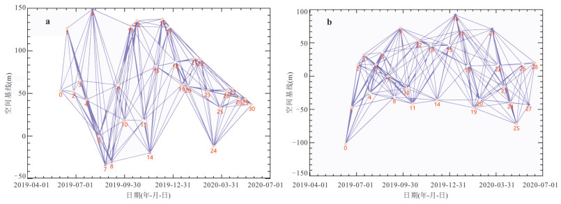
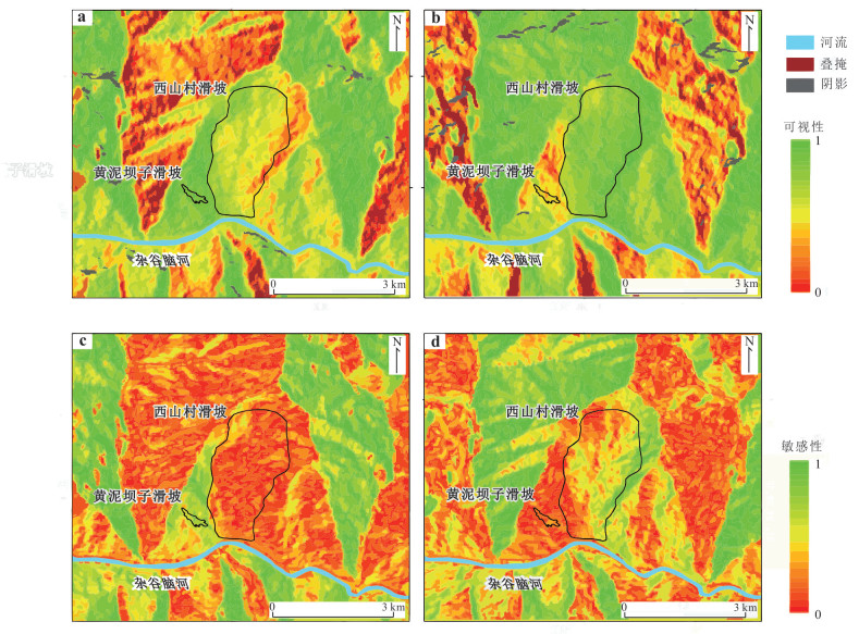
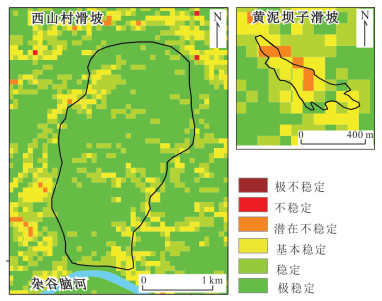
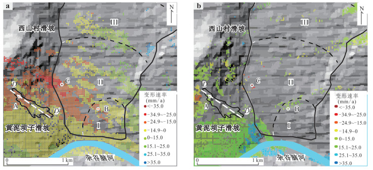
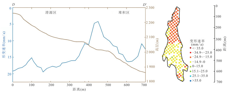
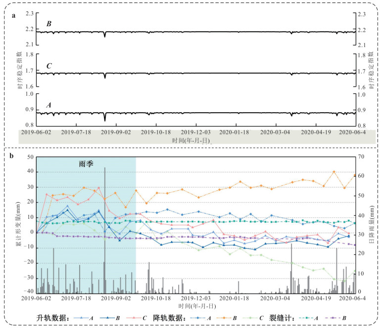
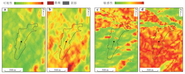
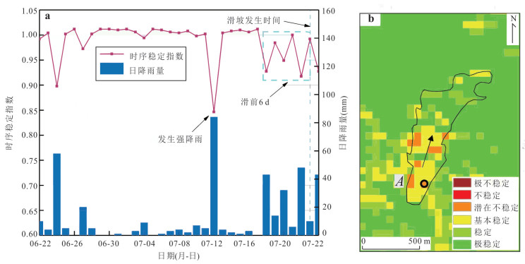
Rainfall-induced rapid landslides triggered by short-duration heavy precipitation often exhibit undetectable precursory deformation in InSAR time series due to geometric distortions and limited temporal sampling. To address this limitation, this study develops an early identification framework that couples InSAR surface deformation monitoring with the physically based SINMAP stability index. Using long-term monitoring data from the Xishancun and Huangnibazi landslides (Lixian County, Sichuan Province), InSAR applicability was first quantitatively evaluated via visibility and measurement sensitivity analyses. In areas of poor InSAR performance, a spatiotemporal cross-validation strategy was established to integrate deformation trends with evolving stability index patterns for comprehensive hazard assessment. Results reveal that the Xishancun landslide is generally stable with only localized frontal instability under rainfall, whereas the Huangnibazi landslide is highly rainfall-sensitive yet challenging to monitor using InSAR alone due to layover and shadow effects. The approach was successfully validated on the 2019 Jichang rainfall-induced rapid landslide (Guizhou Province), effectively capturing pre-failure signals missed by InSAR. This coupled deformation–stability index method significantly enhances early detection of rainfall-triggered rapid landslides and offers a transferable technique for early warning in complex mountainous regions.
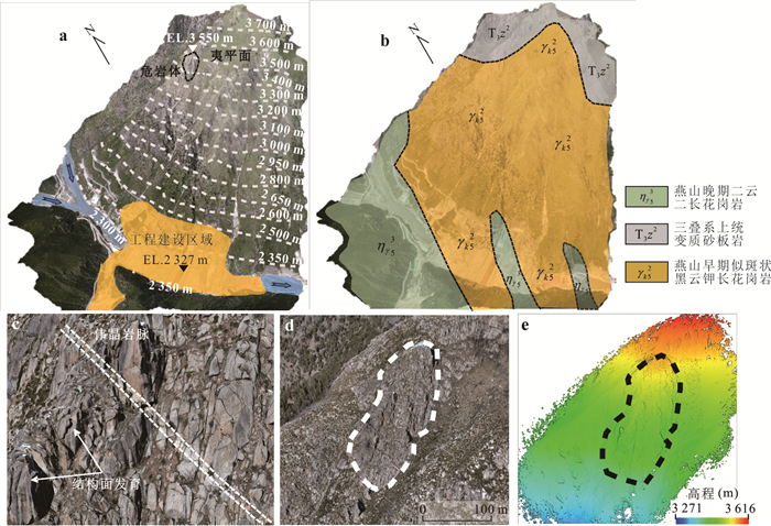
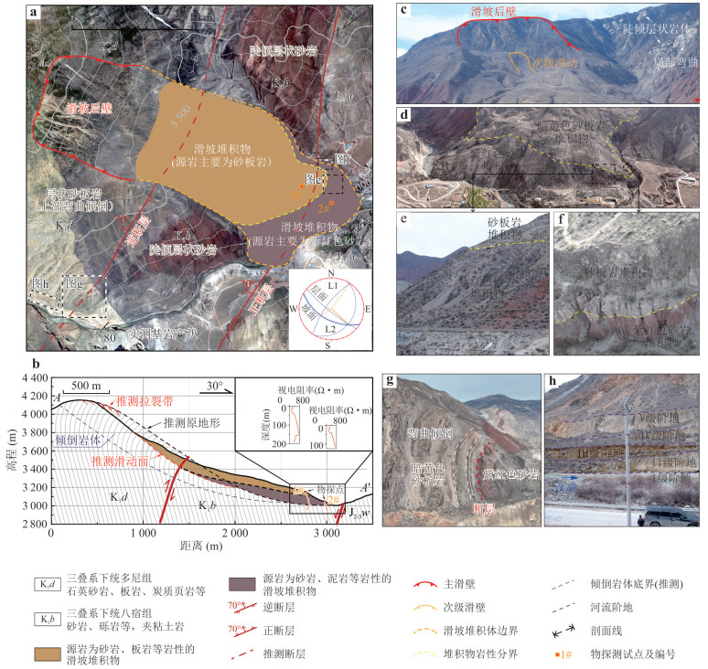
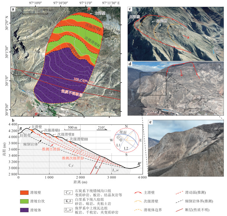
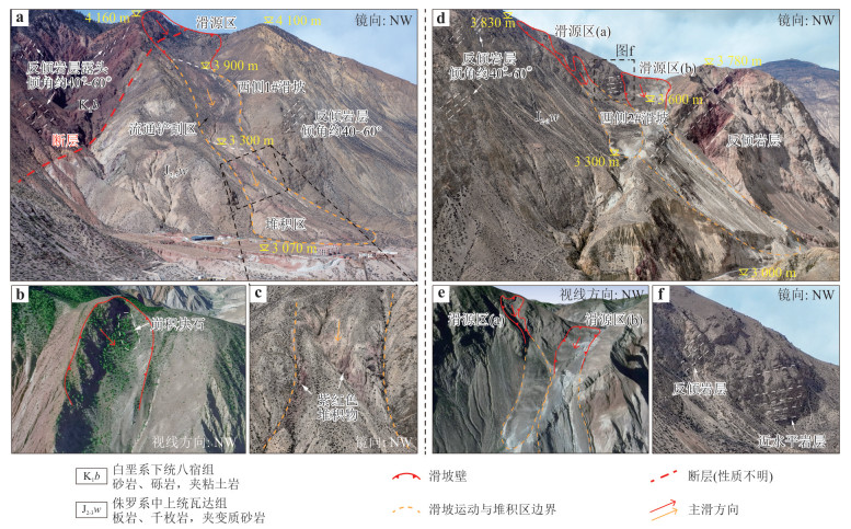
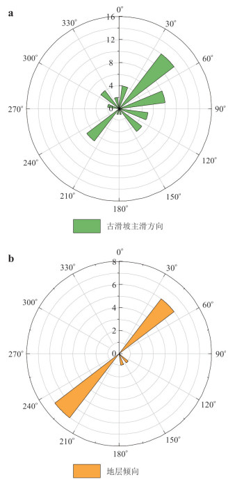
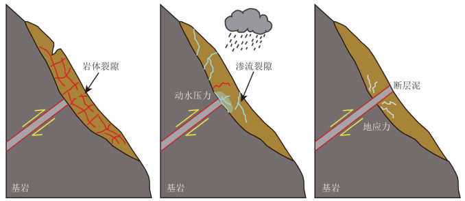
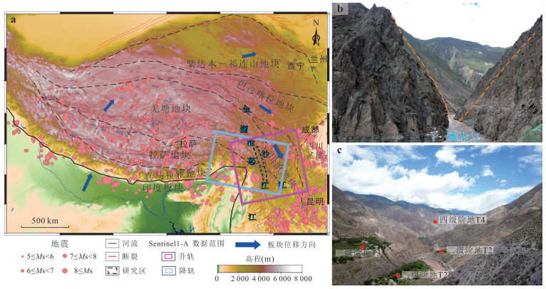
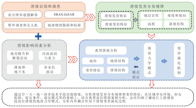
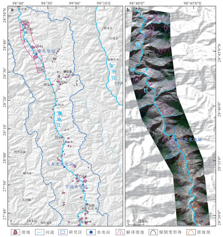
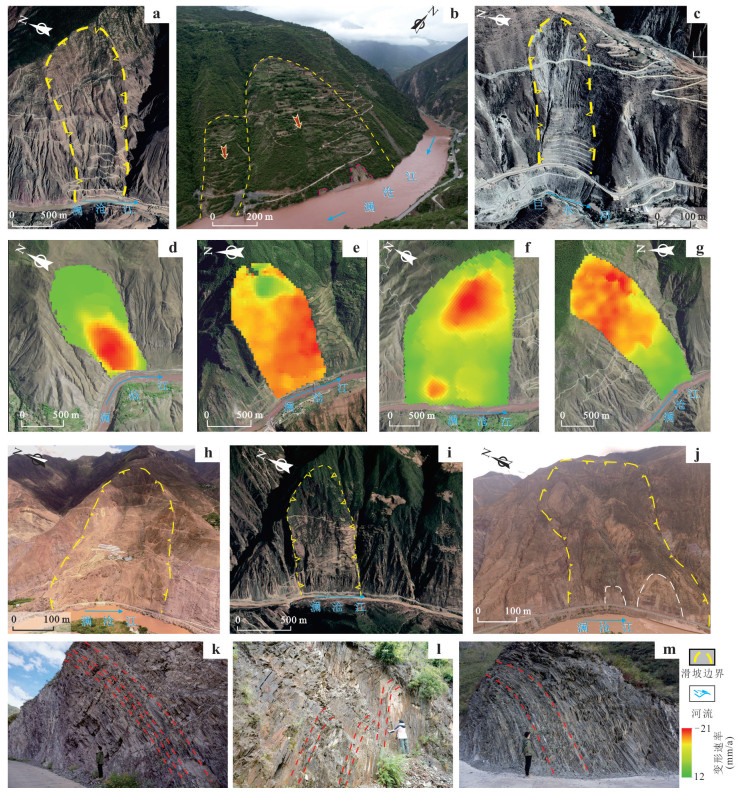
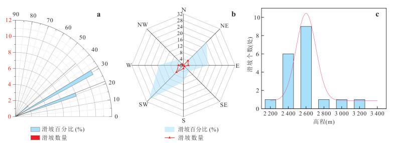
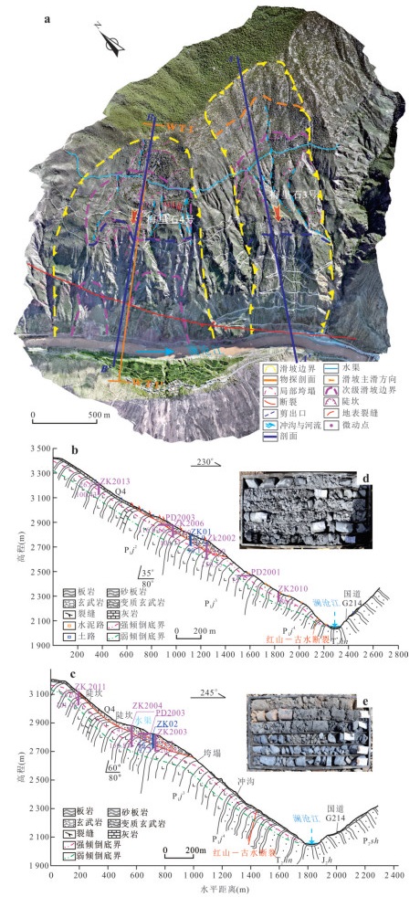
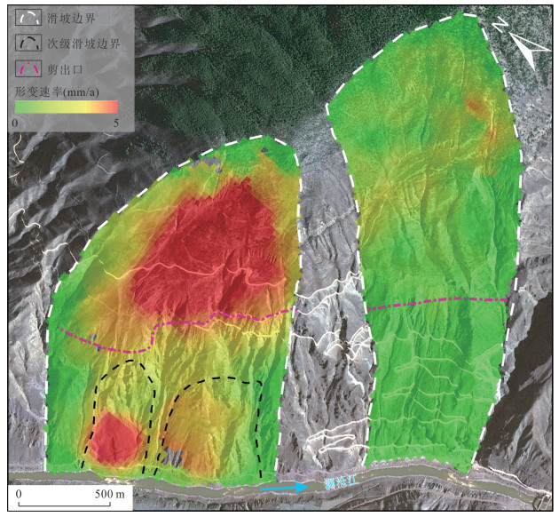
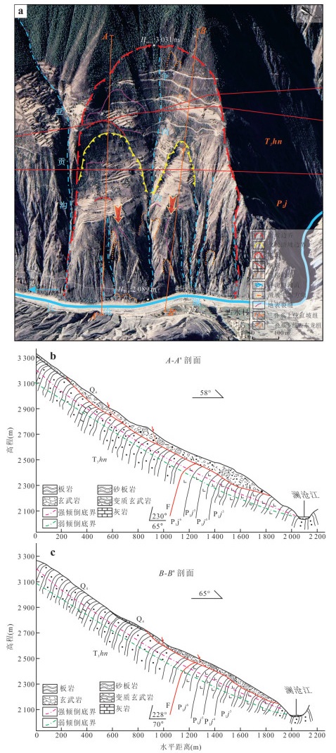
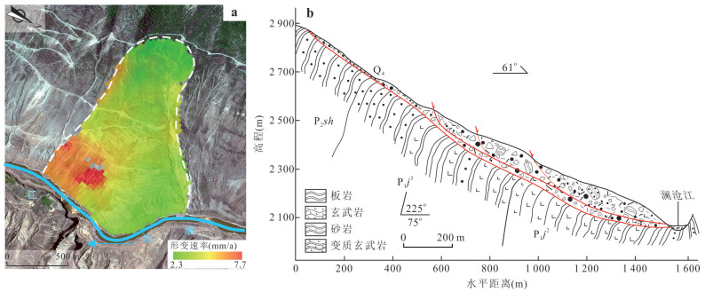
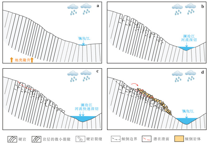
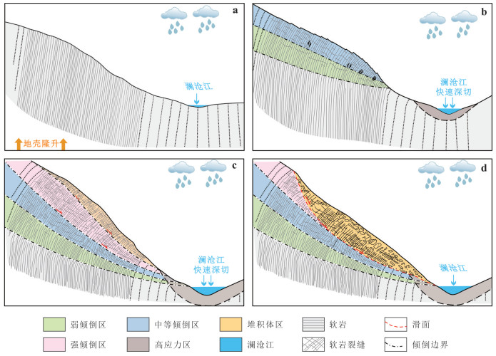
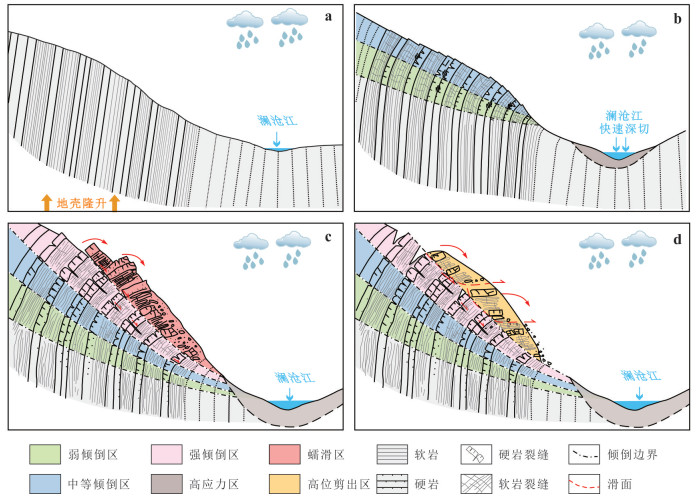
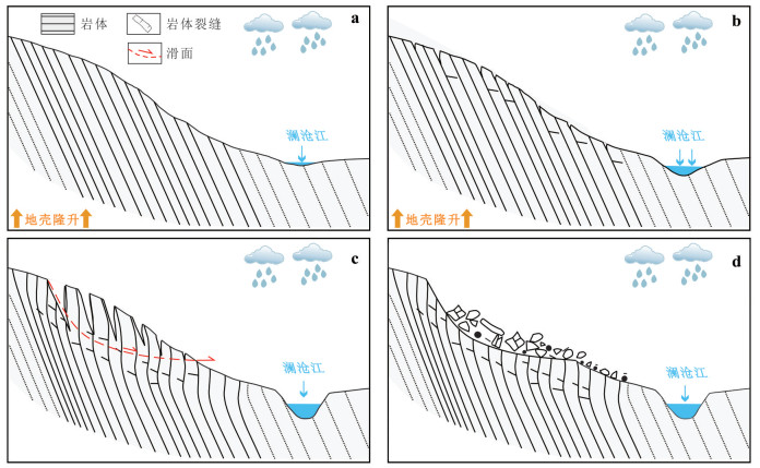
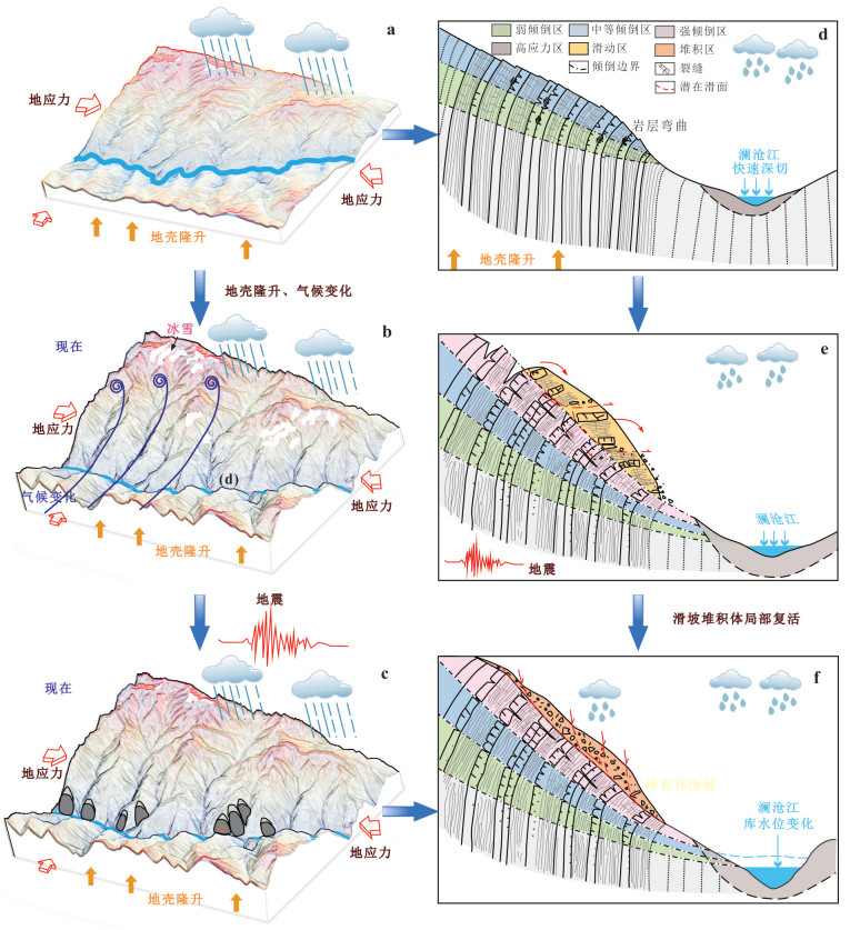
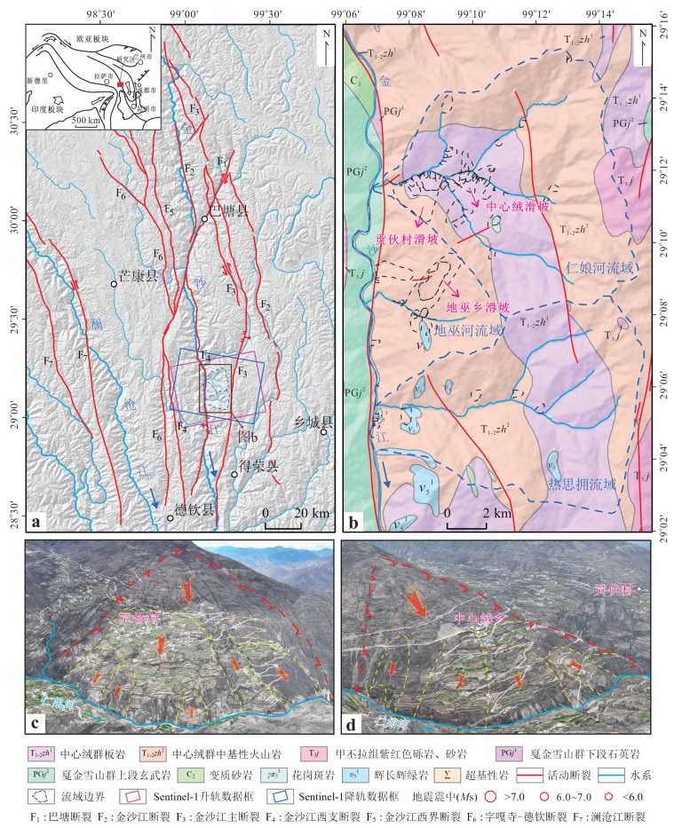
Large high-altitude landslides are widespread along the Deqin reach of the upper Lancang River, exhibiting diverse types, pronounced deformation, and complex evolutionary pathways that readily cascade into basin-scale hazard chains threatening towns and infrastructure. However, the predisposing settings, developmental patterns, and geomechanical models for this reach remain insufficiently constrained. Here it implements InSAR, UAV, field investigation, borehole drilling, and geophysical surveying to delineate the spatial distribution and structural architecture of large high-altitude landslides and to resolve the formation and evolution mechanisms of representative cases. Results show that, under the combined control of extreme relief and lithology-structure coupling, the Foshan township-Yanmen township reach is dominated by large high-altitude landslides, whereas the Yezhi township-Yanmen township reach is characterized by paleo-landslide deposits; toppling deformation zones are pervasive across the study area. It identifies lithology and its assemblage as key factors governing landslide development, and demonstrates that endogenic-exogenic coupling drives formation and evolution: crustal uplift and active faulting provide the tectonic background; deep fluvial incision and long-term unloading promote rock mass toppling and the formation of high-altitude tensile headscarps; rainfall and groundwater processes elevate pore pressure and accelerate internal weakening. On this basis, it synthesizes three classes and eight types of geomechanical failure modes, with toppling dominated failure as the principal mode. Further analyses indicate that landslide deposits are prone to reactivation under earthquakes, intense rainfall, and engineering disturbances. The findings clarify the causative mechanisms and evolutionary pathways of large high-altitude landslides in the Deqin reach and provide a scientific basis for hazard chain mitigation and siting of major engineering works.
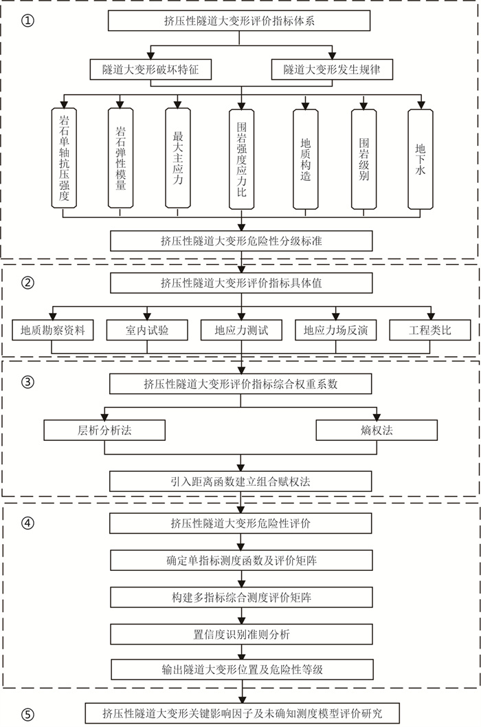
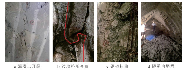
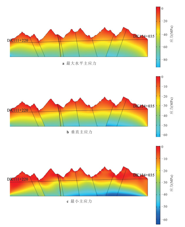
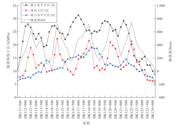
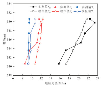
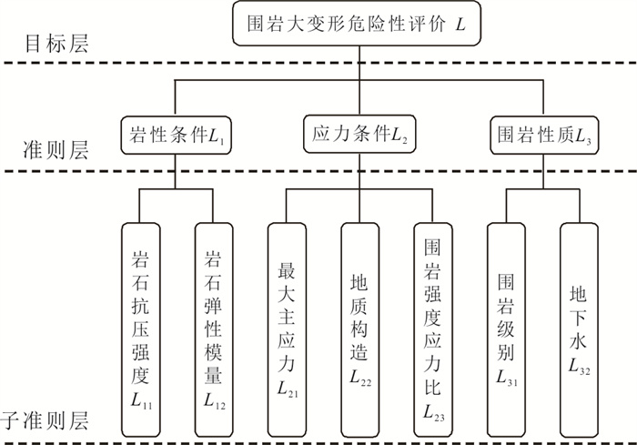
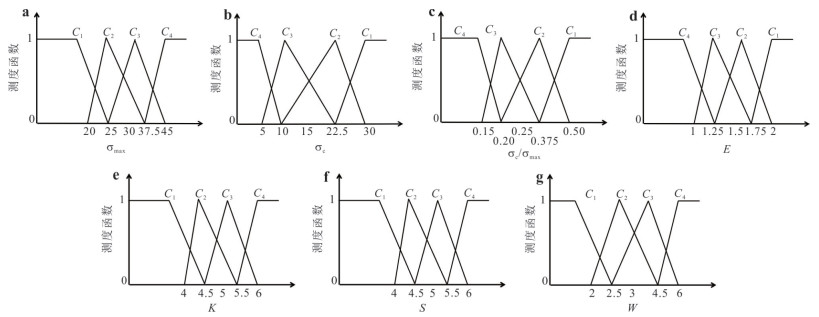
Aiming at the many uncertain factors in the large deformation risk assessment of deep lying tunnel in complex mountainous area, this study proposes a novel evaluation methodology for squeezing tunnel large deformations based on combined weighting method and unascertained measure theory. Through systematic investigation of large deformation characteristics in high-stress deep-buried tunnels, an evaluation system comprising seven core indicators was established, including the rock compressive strength, elastic modulus, maximum principal stress, surrounding strength-stress ratio, geological structure, surrounding rock grade, and groundwater. By employing a distance function to integrate the analytic hierarchy process (AHP) with entropy weighting method, it developed a combined subjective-objective weighting model that achieves scientifically validated weight allocation for risk assessment indicators of squeezing tunnel large deformations. Based on unascertained measure theory, this study establishes a risk assessment model for large deformations in squeezing tunnels. The model employs linear single-index measure functions to construct a measurement evaluation matrix, and utilizes confidence criterion for determining deformation risk levels. The model was applied to four representative soft-rock tunnels with large deformations: Yangjiaping Tunnel on the Chengdu-Lanzhou Railway, and Lingdana, Langzhen No.2, and Jiangmula Tunnels on the Southeastern Tibet Railway. Comparative analysis with actual deformation data demonstrated strong agreement between model predictions and field measurements. These results validate the model's effectiveness and accuracy for risk assessment of large deformations in complex mountainous deep-buried tunnels, establishing a novel approach for such geotechnical evaluations.
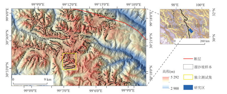
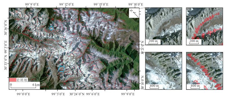
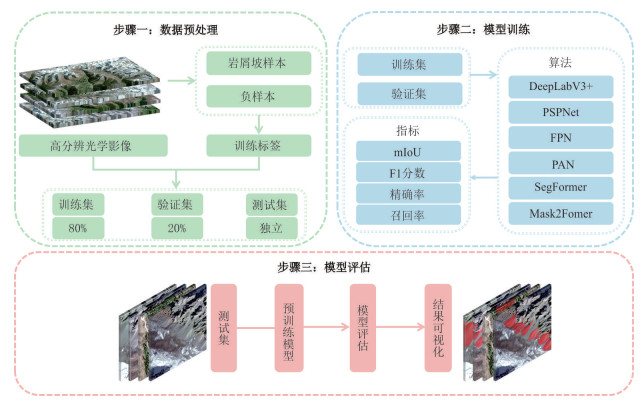
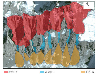
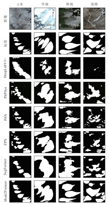
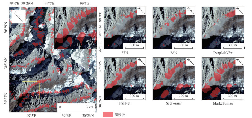
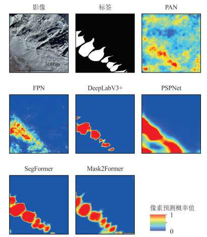
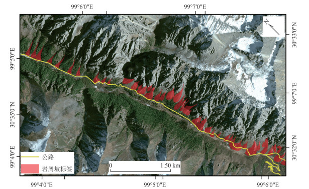
Talus slopes in high-altitude cold mountain regions, characterized by extensive distribution, complex morphology, and elevated geohazard risks, pose significant challenges for intelligent identification due to harsh environmental conditions and data scarcity. This study addresses this gap by constructing the first high-resolution semantic segmentation dataset for talus slope detection. Utilizing Gaofen-2 (GF-2) satellite imagery, it developed a multidimensional interpretation framework incorporating morphological, spectral, and environmental criteria, culminating in an open-access benchmark dataset comprising 3 811 standardized annotated samples. Through systematic evaluation of four convolutional neural network architectures and two Transformer-based models under unified experimental protocols, it validated the technical superiority of the Mask2Former model-integrating Transformer architecture with dynamic Mask attention mechanisms - in complex terrain scenarios, achieving a mean Intersection over Union (mIoU) of 75.72% and F1-score of 77.62%. The proposed methodology has demonstrated exceptional generalization capability and robustness in precise talus slope delineation. This research not only addresses the critical data gap for talus slope studies in alpine environments but also provides scientific guidelines for model selection in intelligent recognition tasks across complex geomorphological settings. The established dataset and multidimensional interpretation system offer valuable references for advancing geohazard monitoring through intelligent remote sensing technologies in cold mountainous regions.
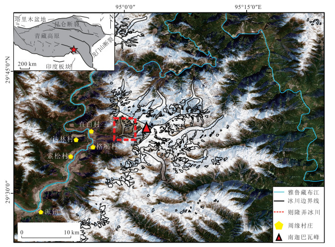
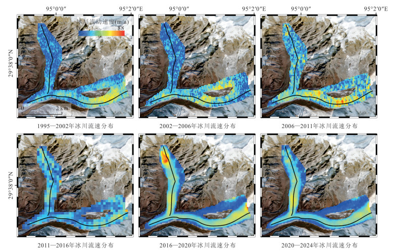
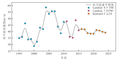
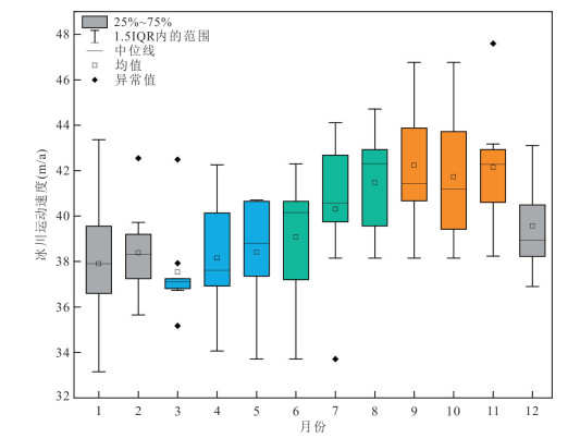
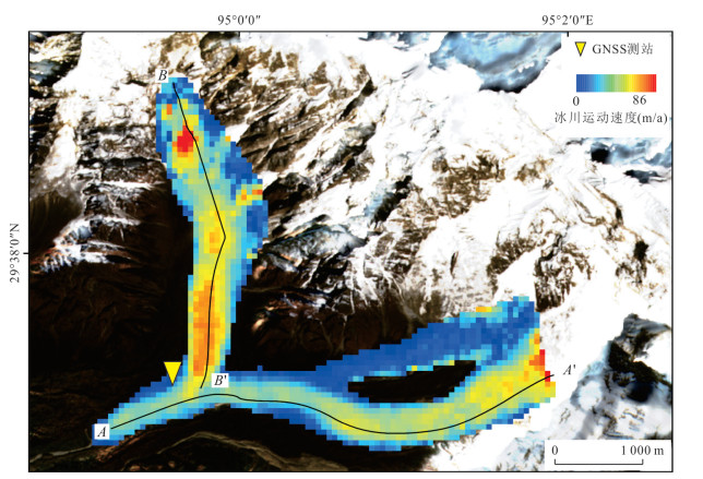
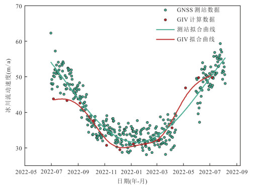
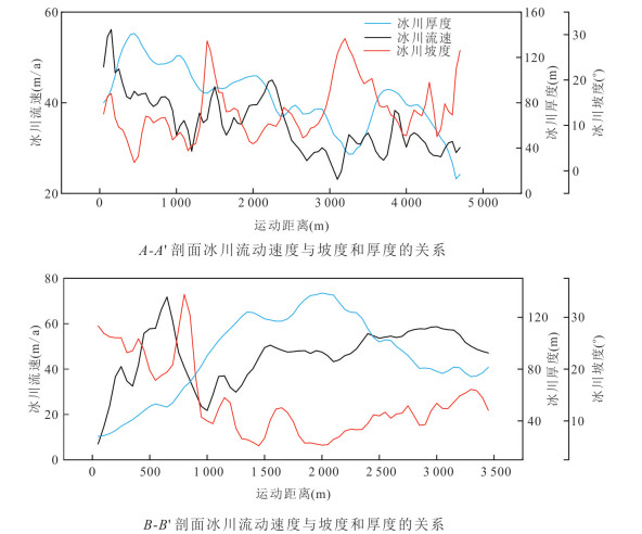
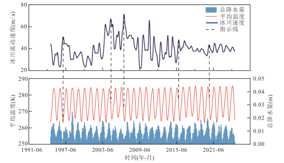
Understanding glacier flow velocity is crucial for revealing the response mechanisms of ice dynamics in high-altitude regions. However, in Southeast Tibet, studies on glacier motion remain limited in both temporal and spatial scales. In this study, it derived the surface velocity of the Zelongnong Glacier in Southeast Tibet using multi-source remote sensing images and feature-tracking techniques. By integrating topographic factors (slope and thickness) with 30-year averages of temperature and precipitation, it examined the glacier's long-term flow characteristics.The results show that the glacier exhibits pronounced seasonal variations in flow velocity, with higher values in summer and autumn and lower values in spring and winter. Velocity is strongly influenced by slope and thickness and shows a gradual increase under global warming. Climate analysis further indicates that glacier flow variations are mainly controlled by seasonal temperature and precipitation, with precipitation effects showing a clear time lag. This lag is closely related to the infiltration and transmission of meltwater to the glacier bed.Long-term observations highlight both the seasonal dynamics and the increasing long-term trend of Zelongnong glacier flow. In addition, potential links between velocity anomalies and geological hazards are discussed. Overall, this study provides new insights into the impacts of climate change on glacier dynamics in Southeast Tibet.
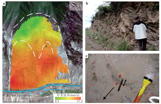
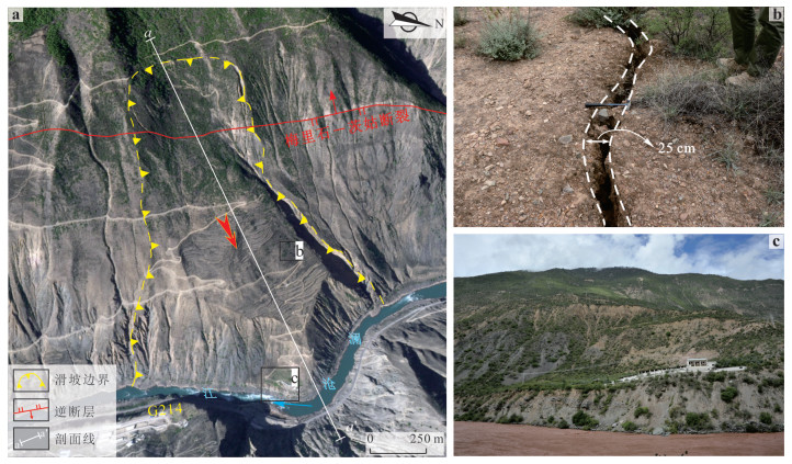
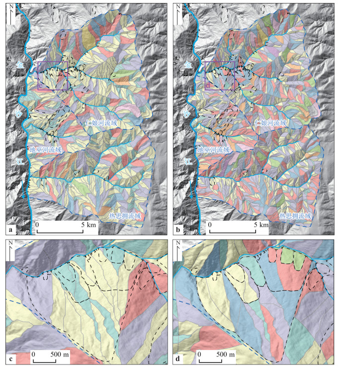
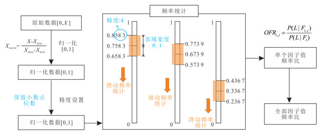
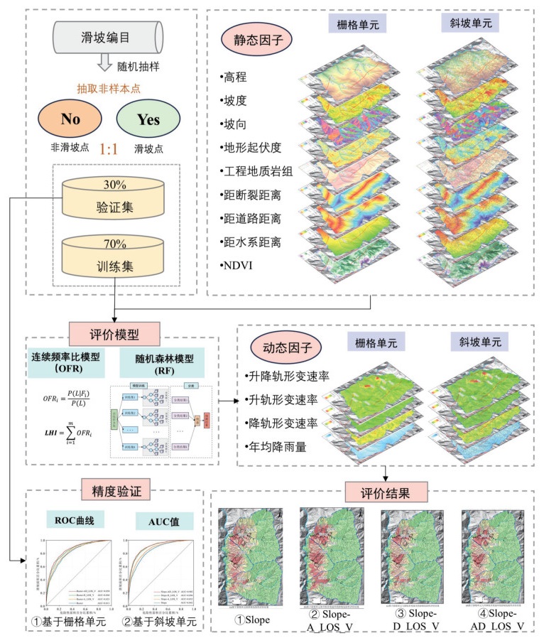
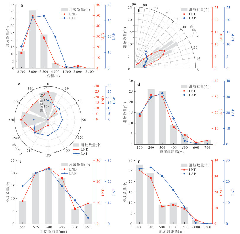
The upper reaches of the Jinsha River, located on the eastern margin of Tibet Plateau, is characterized by intense tectonic activity and frequent landslide disasters in alpine gorge region. However, current landslide hazard assessment models demonstrate limited predictive accuracy, failing to meet the precision requirements for practical disaster prevention and mitigation efforts. This study focuses on the Diwu Township Section in the upper reaches of Jinsha River. Through the integration of remote sensing interpretation and field geological surveys, and based on the regional characteristics of landslide development, it refined the hydrological analysis method to delineate slope units guided by a watershed–geomorphology–slope structure framework. Thirteen evaluation factors were selected, including topographic and geomorphological indicators (elevation, slope, aspect, and terrain relief), lithology, active faults, rainfall, hydrographic network, anthropogenic engineering activities, vegetation coverage, and SBAS-InSAR surface deformation velocity. A novel random forest-continuous frequency ratio (RF-OFR) model was employed to conduct regional landslide hazard assessment. Results demonstrate that slope unit-based evaluation achieves significantly higher accuracy (AUC=0.902) compared to grid unit analysis (AUC=0.858), with delineated high-risk zones showing strong spatial correspondence with documented landslide occurrences. Moreover, within the slope unit framework, the combined ascending and descending SBAS-InSAR deformation results yielded the highest predictive accuracy (AUC=0.902), representing improvements of 6%, 5%, and 0.6% over models using no deformation input, ascending-only, and descending-only data, while significantly improving detection capability for hidden creeping landslides. These findings provide enhanced scientific support for landslide hazard assessment in alpine gorge region and offer valuable references for regional geohazard prevention and risk management strategies.
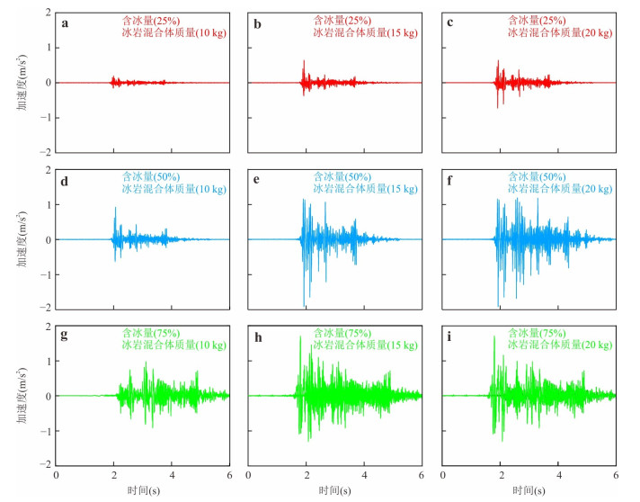
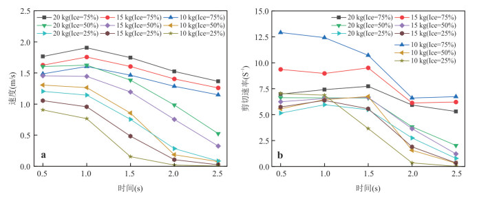
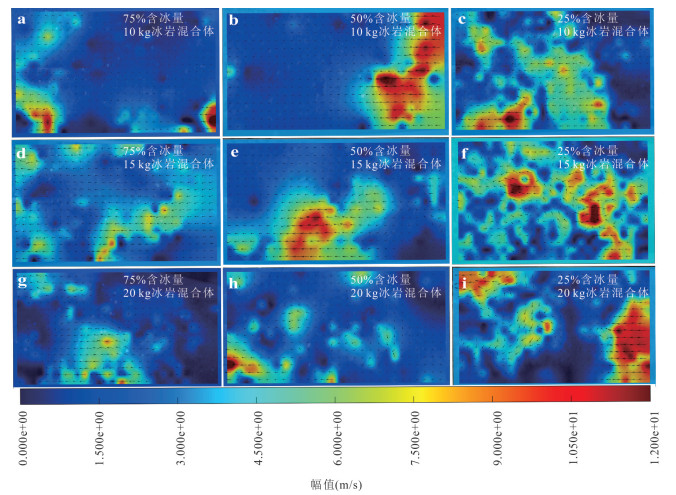
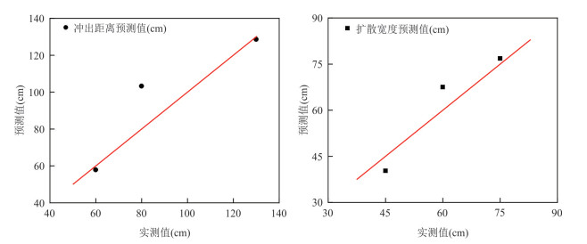
To reveal the low-temperature kinematic mechanism of ice-bearing debris flow transformed from ice-rock avalanches on the Qinghai-Tibet Plateau and quantify the controlling effects of ice content and total mass on its flow behavior, it performed integrated tests under intelligent temperature-controlled conditions. Combining rheological tests of moraine soil slurry and physical model tests of ice-bearing debris flow, it analyzed the influences of varying ice contents (25%, 50%, 75%) and total masses (10 kg, 15 kg, 20 kg) on the dynamic response, velocity field evolution, and deposition characteristics of the debris flows via acceleration monitoring and Particle Image Velocimetry (PIV) inversion.Rheological test results demonstrate that the yield stress of the slurry is highly sensitive to bulk density. Specifically, in low bulk density systems, yield stress increases multiplicatively with rising bulk density, whereas the strengthening effect of moraine materials tends to saturate in high bulk density systems.Physical model tests reveal that the runout distance of ice-bearing debris flow exhibits a significantly positive correlation with both ice content and total mass, with a nonlinear coupling enhancement effect observed between the two factors. Ice content dominates the flow regime transition of the system by regulating the particle contact network, which dictates the evolution direction of the "friction-cementation-lubrication" mechanical behavior. Total mass modulates the transformation intensity of mechanical behavior and energy transfer efficiency through inertial effects. Together, these two factors synergistically control the ultra-long-distance, high-mobility transport capacity of ice-bearing debris flows.It established a multivariate nonlinear prediction model for "runout distance-spread width-impact scope" that incorporates the friction-lubrication coupling mechanism, with a coefficient of determination (R2 > 0.94). This model provides a quantitative basis for hazard range assessment of ice-rock avalanche disasters on the Qinghai-Tibet Plateau, and can effectively guide the route selection, construction, and safe operation and maintenance of major engineering projects.

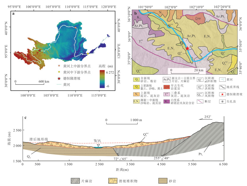
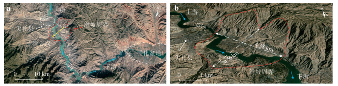
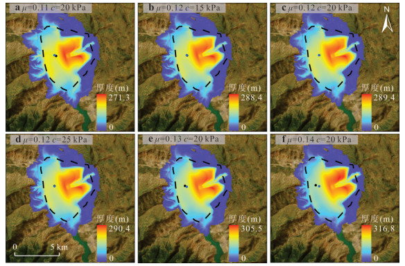
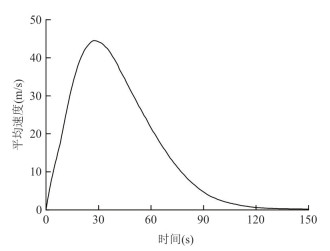
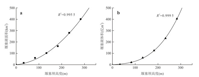
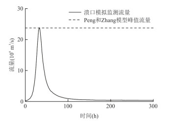
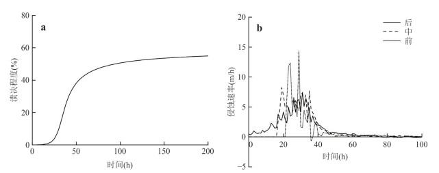
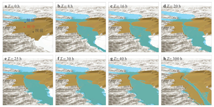
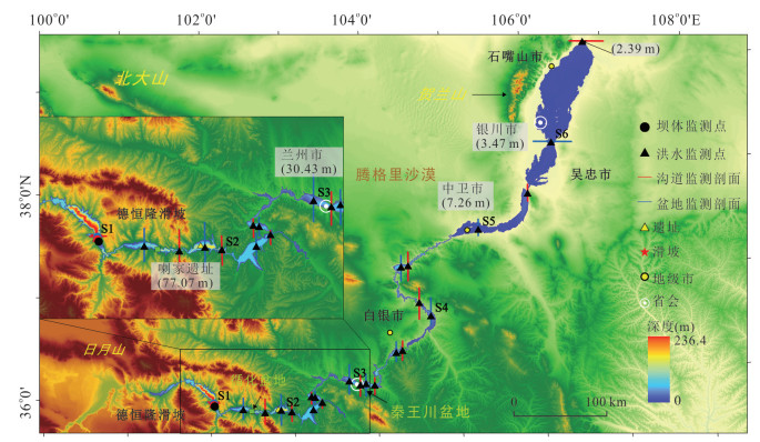
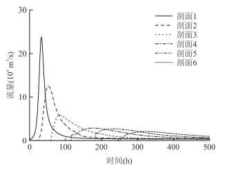
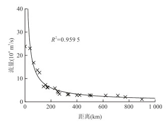
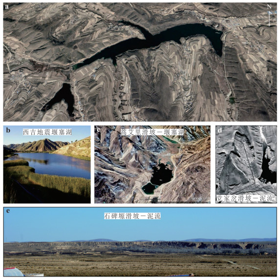
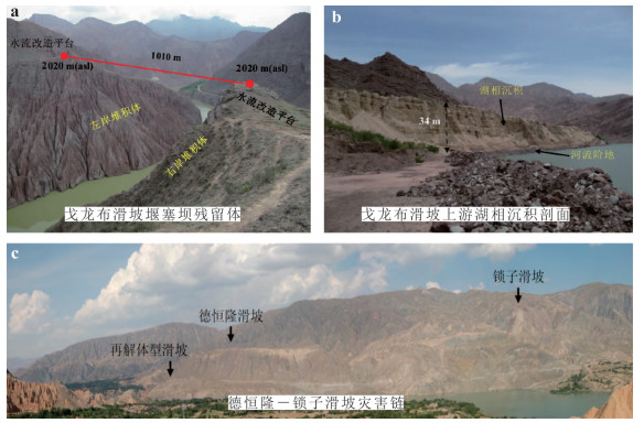
The upper Yellow River canyon on the northeastern margin of the Tibetan Plateau has developed numerous giant paleo-landslide-dammed lake-outburst flood disaster chains. Understanding their kinematic evolution is crucial for mitigating such cascading hazards. Based on field investigations, this study constructs a depth-averaged landslide damming kinematic model and a coupled outburst flood dynamics model incorporating sediment transport and physical erosion/deposition mechanisms, using the typical Dehenglong giant landslide disaster chain as a case study. The simulation systematically analyzes the entire kinematic process, including landslide damming, lake formation, and dam breaching. The results indicate that the Dehenglong landslide had a volume of 3.50 billion m3, reached a peak average velocity of 44.5 m/s, and had a total sliding duration of 120 s. This formed a 234 m-high dam that blocked the Yellow River, creating a giant dammed lake with an area of 280 km2 and a storage capacity of 23.23 billion m3. The dam breach lasted 100 h, with a peak discharge of 238 300 m3/s. The resulting flood propagated 900 km downstream along the Yellow River, reaching a maximum water level of 158 m. Compared to the landslide movement distance itself, this giant landslide-damming-outburst flood disaster chain affected a vast area spanning approximately 1 000 km of the river channel, exhibiting a significant disaster amplification effect. The findings of this study provide a scientific basis for risk assessment and disaster prevention decision-making regarding landslide disaster chains along the Yellow River Basin.
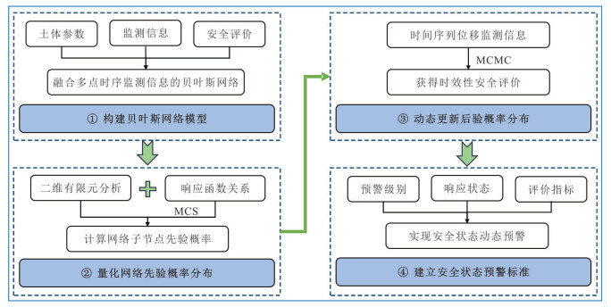
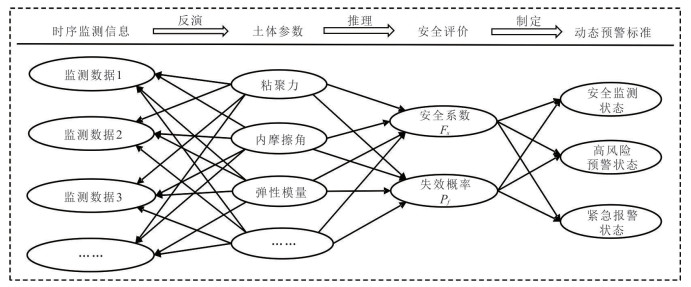
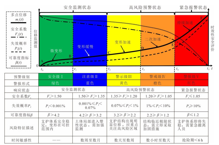
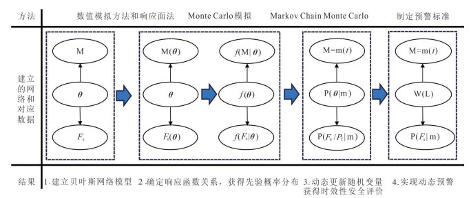
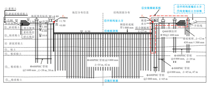
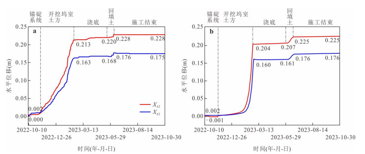
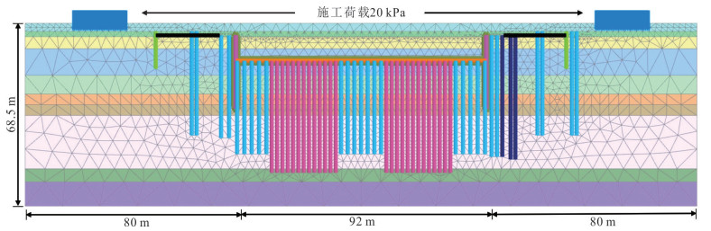
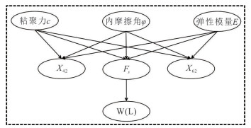
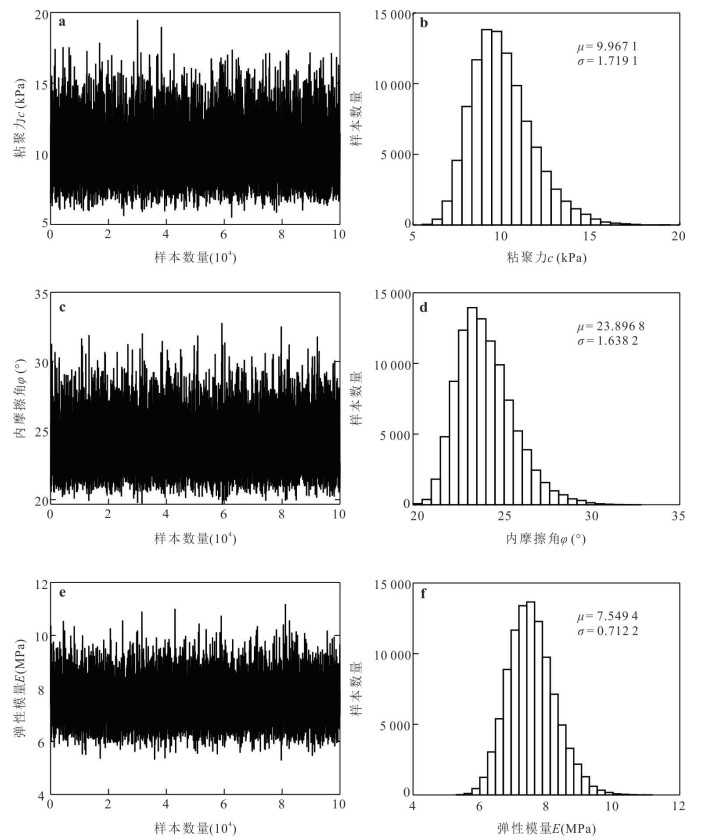
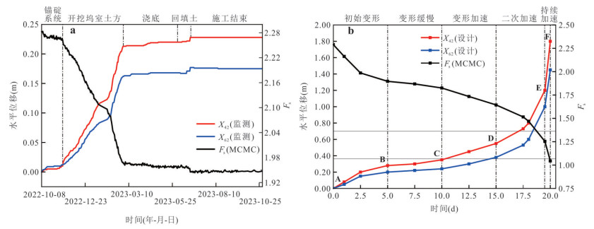
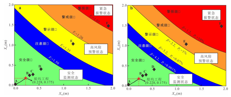
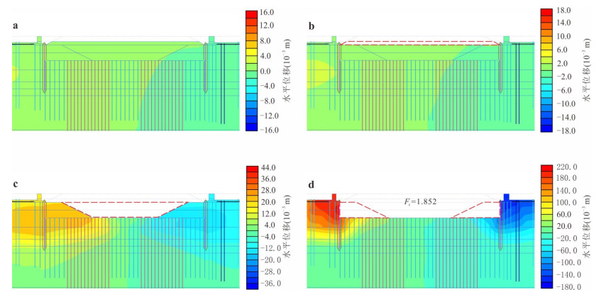
Dock engineering in soft soil stratum faces challenges such as high uncertainty of soil parameters and large errors in traditional early warning due to complex geological conditions and long construction periods. To address these issues, this study proposes a dynamic early warning method for safety status based on multi-point time-series monitoring information fusion. First, a Bayesian network model is constructed, which utilizes the response relationships of network nodes and Monte Carlo Simulation (MCS) to calculate prior probabilities. Then, time-series monitoring data are introduced to update posterior probabilities through the Markov Chain Monte Carlo (MCMC) Simulation, dynamically quantifying indicators such as the safety factor (Fs) and failure probability (Pf) to establish a direct correlation between monitoring information and safety status. Finally, based on the characteristics of soft soil and relevant specifications, dynamic early warning criteria incorporating 5 warning levels and 3 response states are established. Applying the method to a dock project in Shanghai, this method integrates multi-point time-series monitoring information for parameter inversion, effectively reducing the uncertainty of soil parameters (with the coefficient of variation decreased by 14%-30%). Meanwhile, it realizes time-sensitive safety evaluation, where the time-varying curve of the safety factor shows a regular decrease as deformation increases. Based on this, a hierarchical dynamic early warning standard is established, which determines that the dock is in Safety Level I during the construction period (Fs=1.945 > 1.50, Pf < 0.001%). Additionally, the feasibility of the early warning standard triggering alerts under hazardous conditions is verified through extreme working condition simulation. The proposed dynamic early warning system significantly improves the accuracy of parameter inversion and the accuracy and real-time performance of safety evaluation, effectively avoids the risk of false alarms from single-source data, enhances the precision and comprehensiveness of dynamic early-warning, and provides a scientific method for risk prevention and control in similar engineering projects.
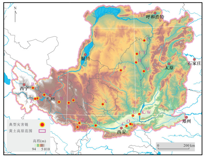
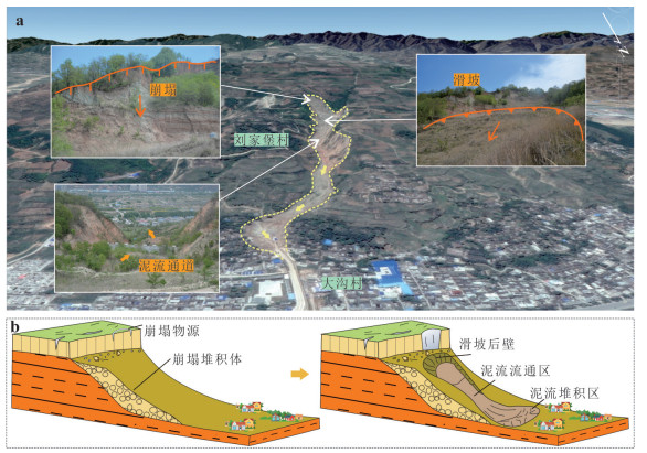
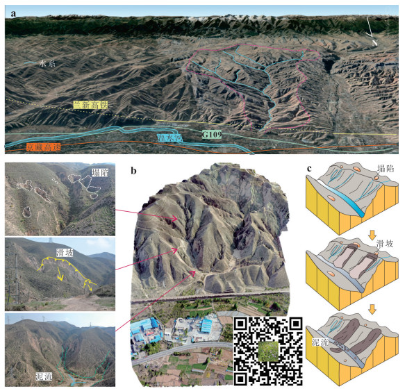
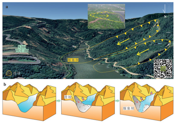
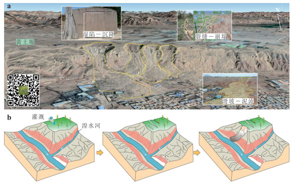
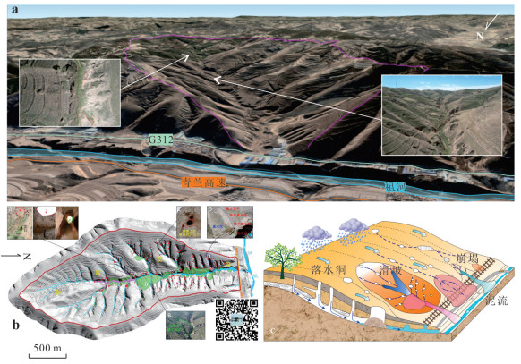
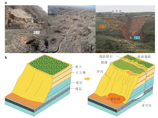
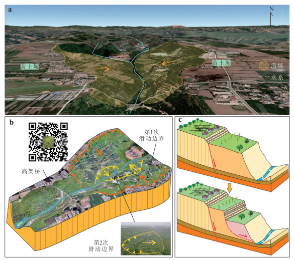
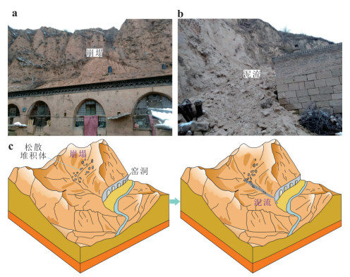
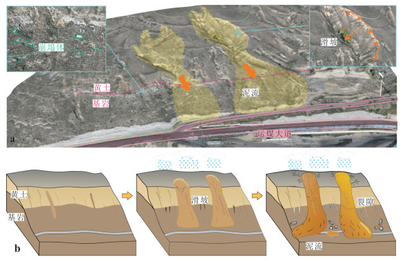
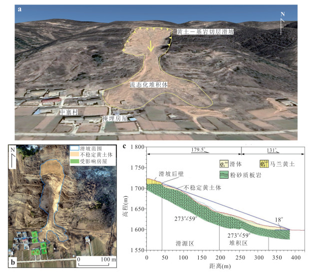
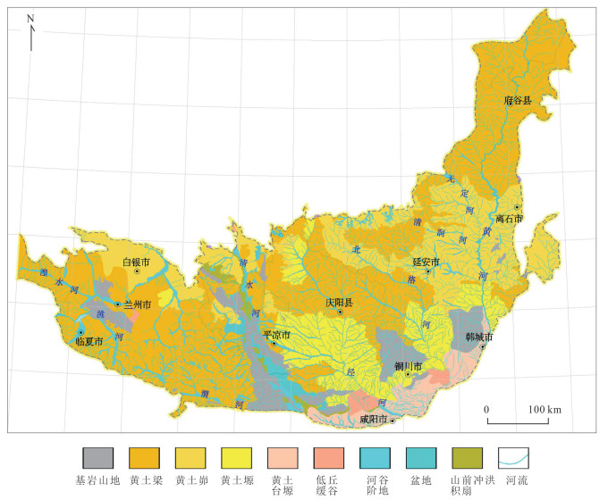
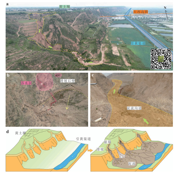
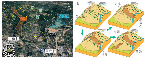
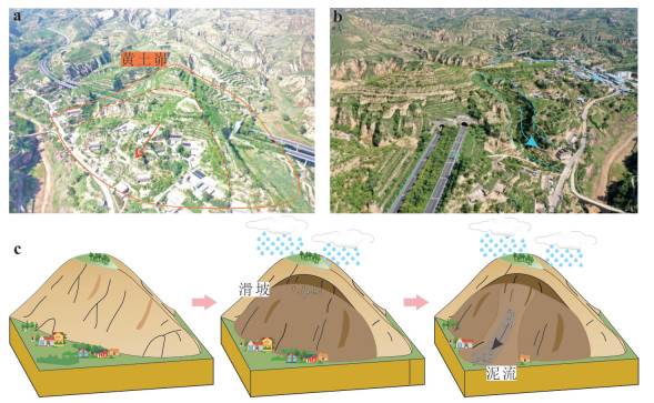
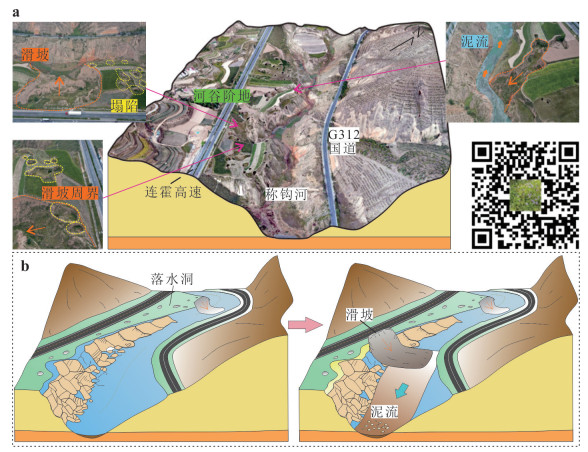
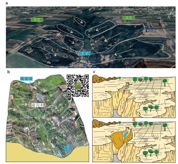
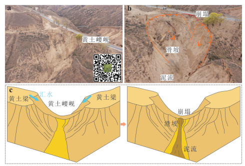
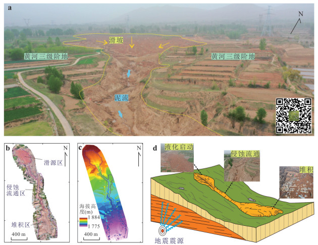
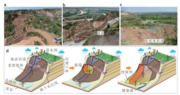
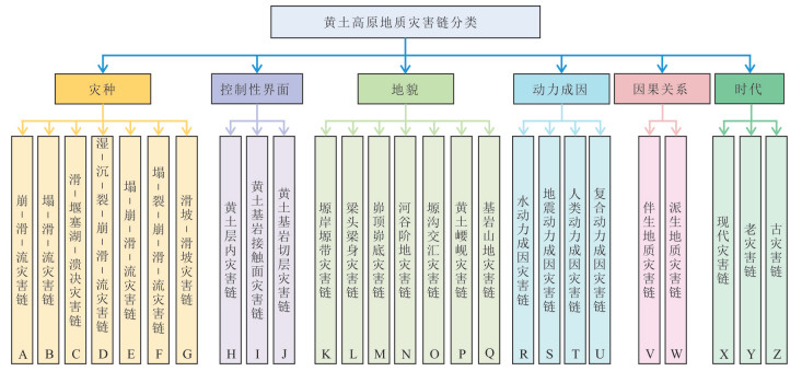
In recent years, against the backdrop of the risk of heavy rainfall brought about by global warming, geological disasters on the Loess Plateau have shown new trends of change. They often form a chain of geological disasters in the Loess Plateau in a chain-like form, which frequently possess characteristics such as high frequency, concealment, catastrophic nature and complexity. It is urgent to clarify the development characteristics of the geological disaster chain on the Loess Plateau and classify it scientifically and systematically. Based on extensive research and summary of the classification of various geological disasters in the Loess Plateau region, a comprehensive analysis of typical geological disaster chains in the Loess Plateau region was conducted through a large number of field investigations, unmanned aerial vehicle aerial surveys, and indoor remote sensing image analyses. The geological disaster chain of the Loess Plateau was systematically summarized from several aspects such as disaster types, controlling interface, geomorphology, dynamic causes, causal relationships and formation eras. A classification system of 6 major categories and 26 subspecies of geological disaster chains of the Loess Plateau was proposed. The development characteristics and disaster formation patterns of typical geological disaster chains of loess were summarized. It reveals the chain structure of typical geological disaster chains and the influence relationships among them. This research can provide theoretical references for the prevention and control of geological disaster chains in the Loess Plateau, and is conducive to the implementation of targeted disaster reduction and prevention work for the loess disaster chain.
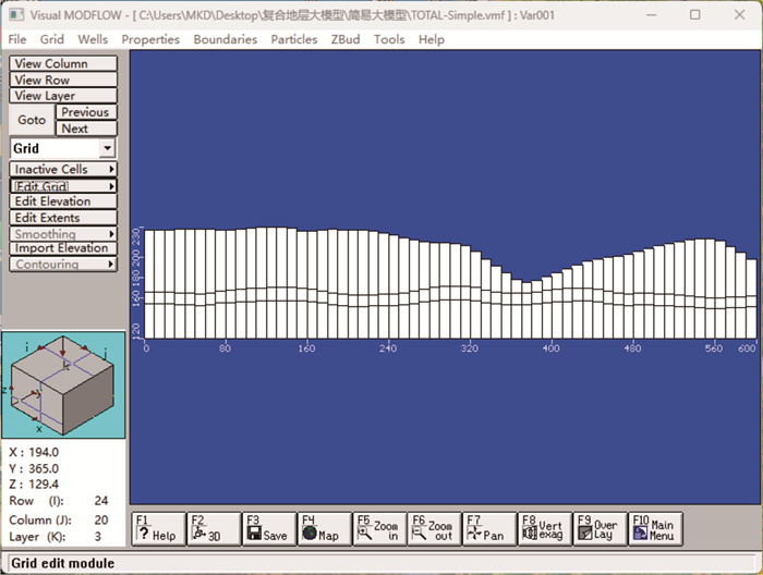
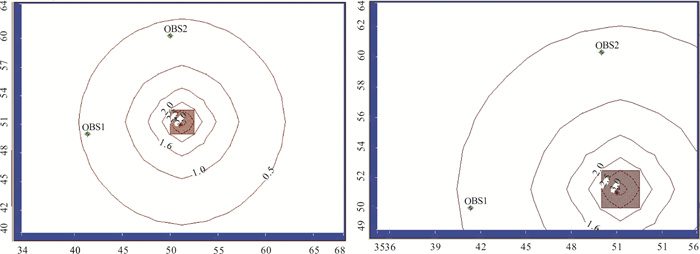
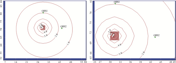
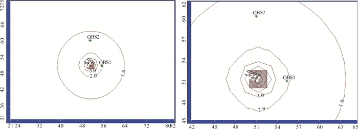
Taking a landslide area in Guangdong Province as the research object, Visual MODFLOW is used to process the elevation data of landslide area and establish an accurate 3D model combined with the geological exploration report of landslide area. After the three-dimensional landslide model is established, the corresponding model parameters are calculated and input through the field hydrogeological test data. Then, the numerical inversion method is used to simulate the hydrogeological test process. By inversion of hydrogeological parameters, the numerical simulation results of observed well water level at different positions are consistent with the actual measurement results. Thus, the hydrogeological parameters closest to the actual site are determined. In this paper, the hydrogeological parameters of the landslide area are obtained from both numerical simulation and theoretical calculation, and the results obtained by the two methods are not very different. Therefore, the numerical simulation method adopted in this paper can more conveniently obtain the hydrogeological parameters of the landslide area. The obtained data can be used to accurately evaluate the influence of groundwater on landslide, and provide scientific basis for landslide prevention and control and improvement of regional hydrogeological conditions.
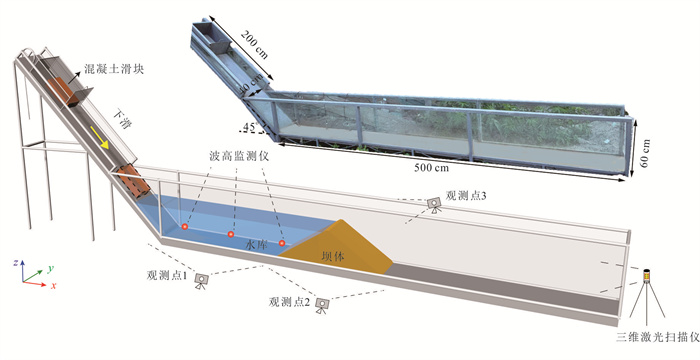
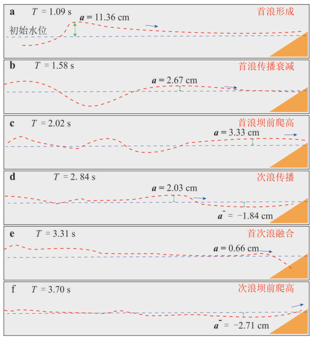
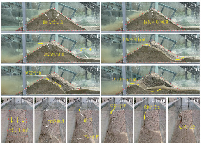
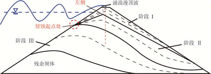
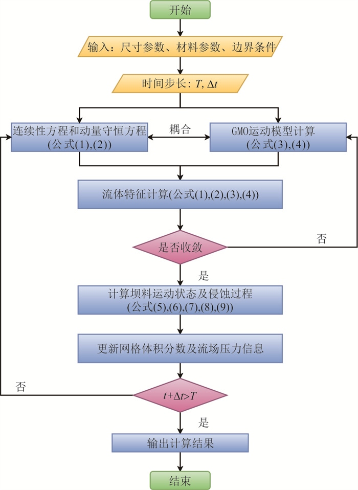
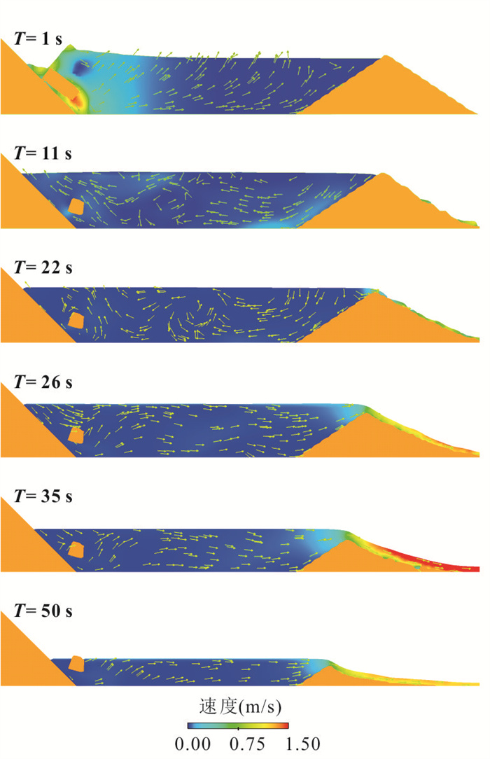
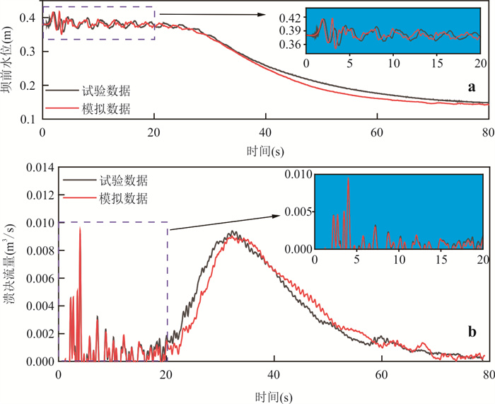
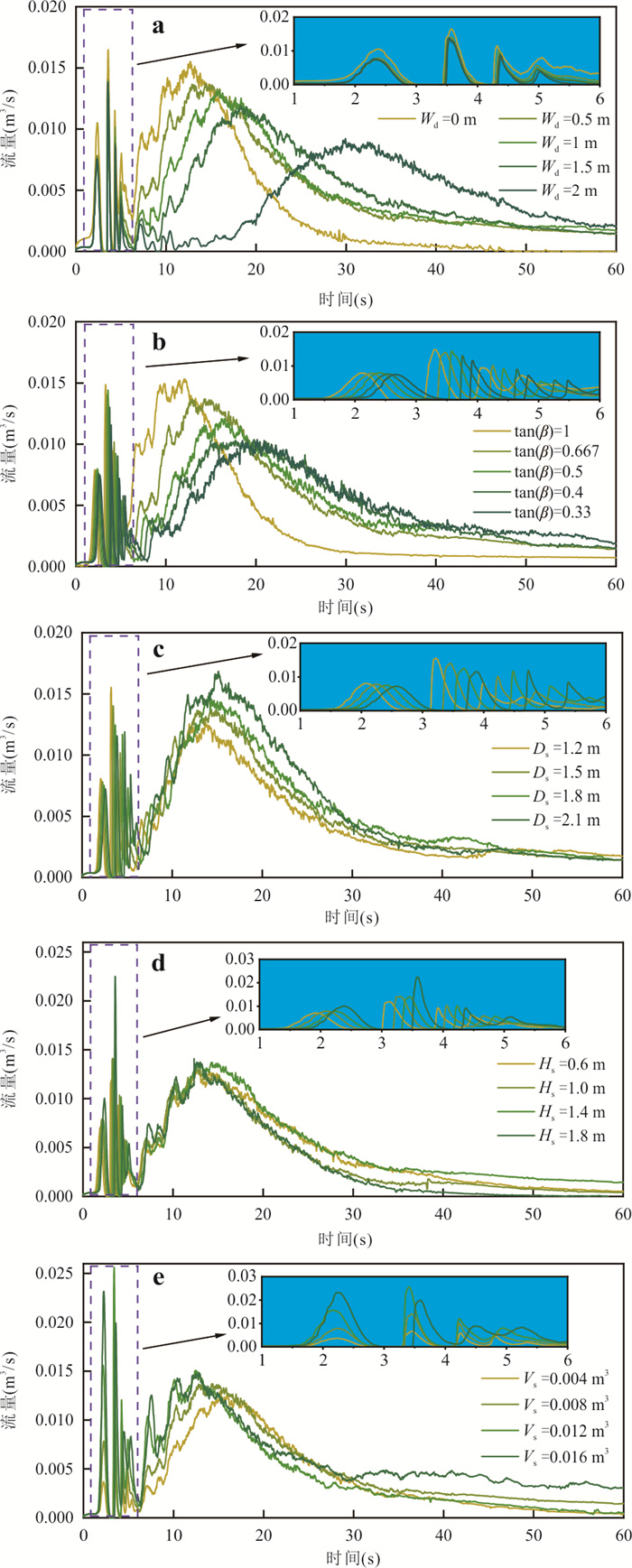
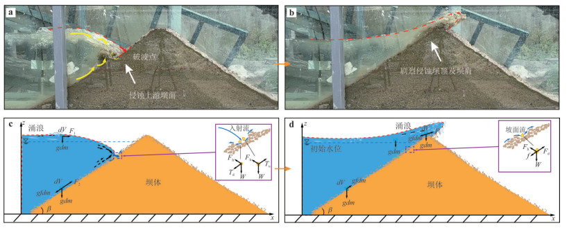
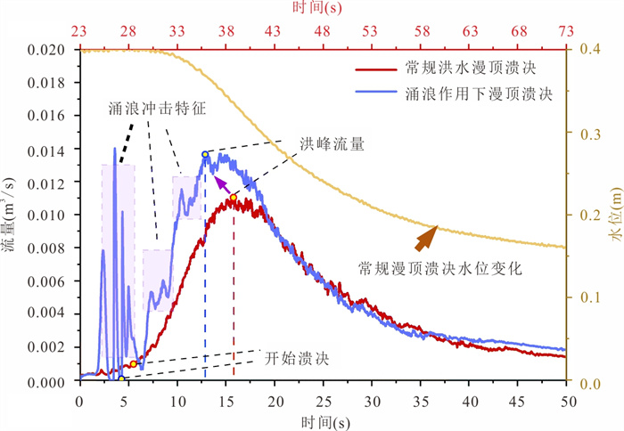
The disaster chain initiated by near-dam reservoir landslides, characterized by its abrupt onset, cascading nature, and severe destructive potential, poses a significant threat to hydraulic structures and downstream safety. This study presents integrated physical model tests simulating landslide-generated impulse waves and subsequent dam breaching. Key data on wave evolution, dam erosion, and the breach process were systematically recorded, revealing the failure mechanisms of earth-rock dams subjected to wave impact. Leveraging the experimental data, a refined three-dimensional numerical model was developed using the Finite Volume Method. This model couples modules for landslide motion, hydrodynamics, and dam material erosion. The reliability of the numerical model was validated against the experimental results. A parametric study was then conducted to investigate the influence of key factors, including landslide volume, fall height, dam geometry, and landslide location, on the breaching process. The results demonstrate that wave impact significantly accelerates dam erosion, leading to an increased peak discharge and an advanced breach timeline, highlighting a clear disaster amplification effect. This study provides both a theoretical foundation and an advanced simulation methodology for the risk identification and assessment of cascading geological hazards in near-dam reservoir areas.
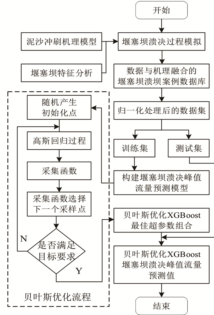
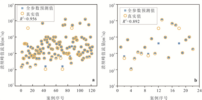
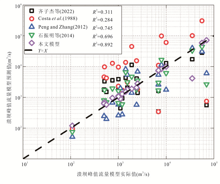
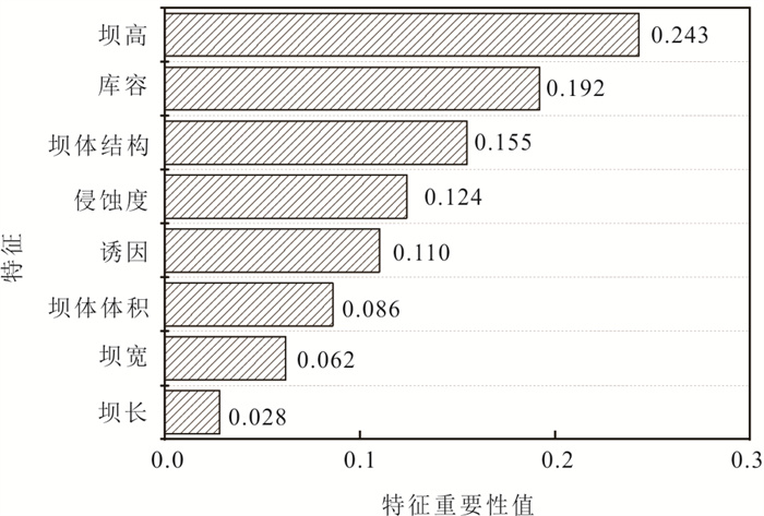
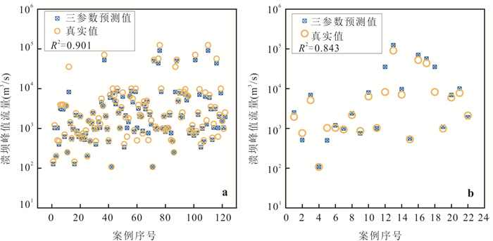
Accurate and rapid assessment of peak flood discharge from landslide dam breaches is crucial for emergency response efforts. Predicting breach parameters of sudden landslide dam failures using machine learning methods has become a current research focus. However, existing landslide dam database slack sufficient case records, and current predictive models for peak breach discharge fail to capture the nonlinear interactions among influencing factors, resulting in limited generalization capability. In response to this, this study employs a sediment erosion model to simulate the landslide dam breach process, thereby expanding the landslide dam breach case database. The Extreme Gradient Boosting (XGBoost) machine learning algorithm is used to predict the peak flood discharge of landslide dam breaches, and the Bayesian algorithm is employed to optimize the hyperparameters of the XGBoost model. An innovative machine learning prediction model for peak flood discharge of heterogeneous landslide dam breaches is proposed, considering eight influencing factors, including geometric parameters of the dam (height, width, length, volume), reservoir capacity, triggering factors, and material composition (erodibility and structural type). The results indicate that, compared to traditional models, the Bayesian-optimized XGBoost machine learning model exhibits higher prediction accuracy. Case analyses of Tangjiashan and Baige landslide dams confirm that the model's predicted peak flood discharge has a maximum error of approximately 20% compared to the actual values. This study provides a valuable reference for emergency response and regional disaster mitigation in the context of landslide dam breaches.
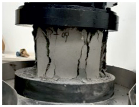
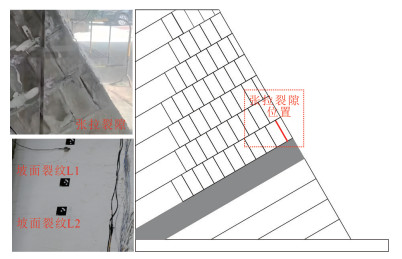
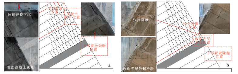
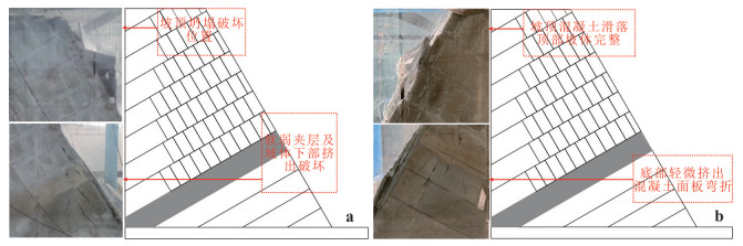
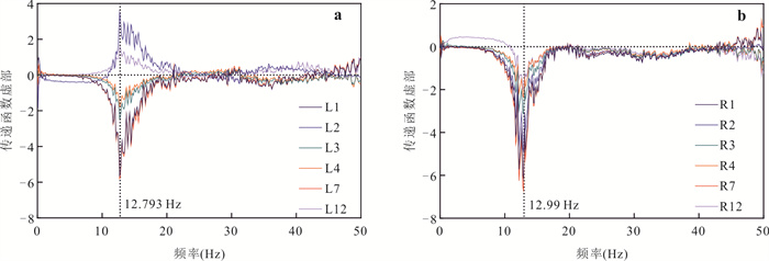
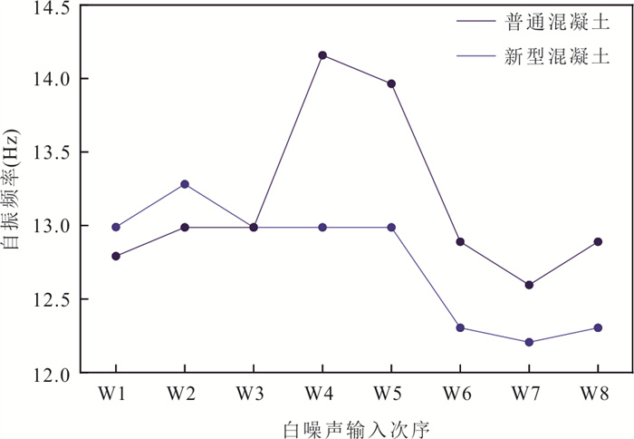
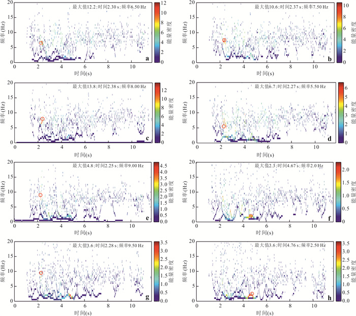
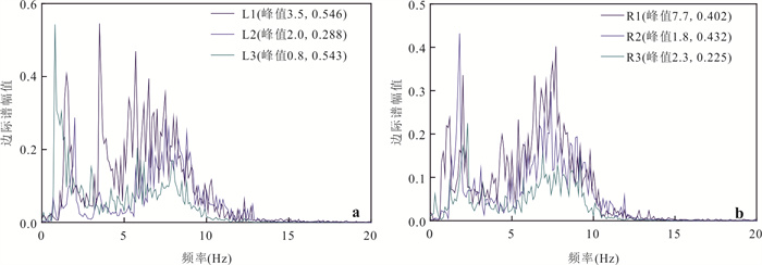
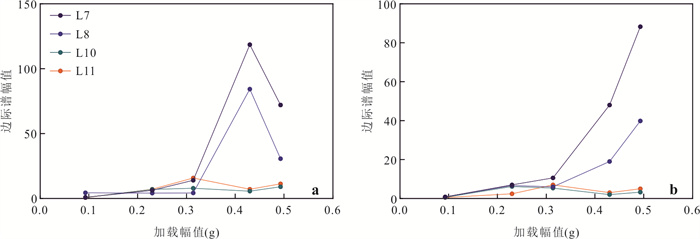
To solve the problems of traditional shotcrete, such as high rigidity, poor ductility, and easy cracking and failure during seismic activities, a new type of flexible concrete material was developed. Based on a new type of flexible shotcrete mixed with polypropylene fibers and bentonite and taking the Ludian Hongshiyan landslide as a prototype, a comparative shaking table test of slopes protected by new - type concrete (NC) and ordinary concrete (OC) was carried out. The dynamic response and damage evolution mechanism were analyzed. Under seismic loading, the natural vibration frequency of the slope protected by NC changed less and was more stable than that of the slope protected by OC. Hilbert-Huang analysis shows that the energy response of the slope protected by NC was significantly distributed at the main frequency of the seismic wave. In contrast, the energy of the slope protected by OC was concentrated nearly at the natural vibration frequency. The marginal spectrum energy further revealed that the damage initiation time of the NC slope was delayed, the energy dissipation process was more stable, and the structural integrity was better maintained under strong earthquakes. The new -type concrete significantly improves the seismic performance of slopes by enhancing the interface coordination and energy-dissipation capacity. It provides a technical approach with stronger ductility and better damage resistance for the prevention and control of shallow landslides in seismic areas.
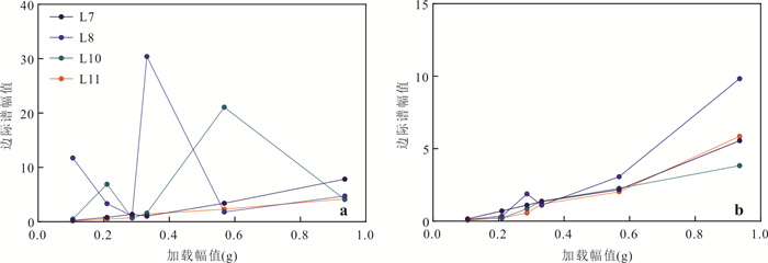
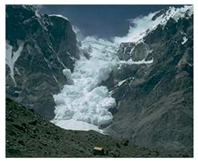
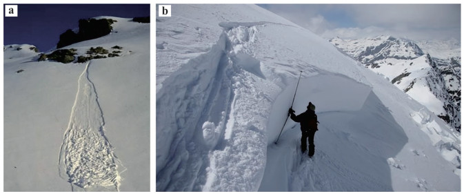
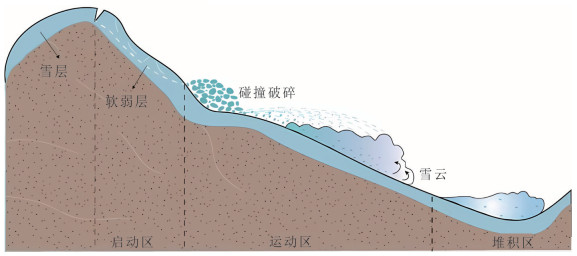
Investigation of avalanche formation mechanisms and pre-disaster hazard assessment is critically significant for disaster prevention and mitigation. This study synthesizes the characteristic distribution patterns of avalanches and primary classification methodologies, systematically elaborates on influencing factors and the mechanisms governing avalanche initiation, movement, and deposition. It comprehensively reviews computational approaches for snowpack stability, avalanche runout distance, and hazard level classification. On this basis, five key aspects are identified as requiring focused attention in future research: (1) A globally snow avalanche database is needed to provide a foundational resource for studies of avalanche formation and dynamics. (2) Dynamic evolution of snowpack mechanical properties under extreme climatic conditions and the coupled effects of terrain and climate on snowpack characteristics is needed, thereby elucidating the spatiotemporal patterns of avalanche activity. (3) Quantitative models for avalanche initiation probability, crack propagation mechanisms, and initiation-related fracture growth characterization methods are needed. (4) Examine erosion-deposition feedbacks and mass-energy transfer during avalanche motion, and derive quantitative relationships between deposit morphology and controlling factors are needed. (5) Runout estimation methods based on avalanche dynamics and dynamic risk assessment framework are needed to provide important reference for disaster prediction and mitigation.

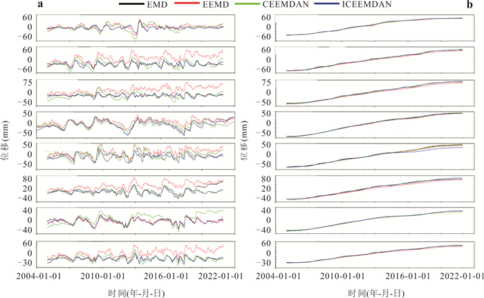
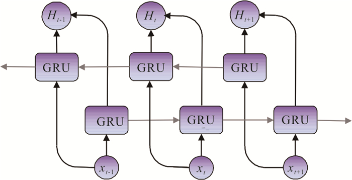
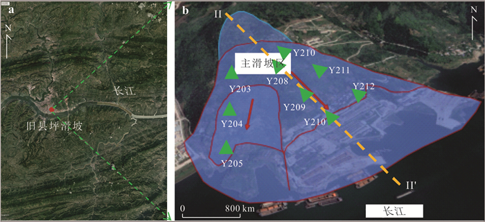
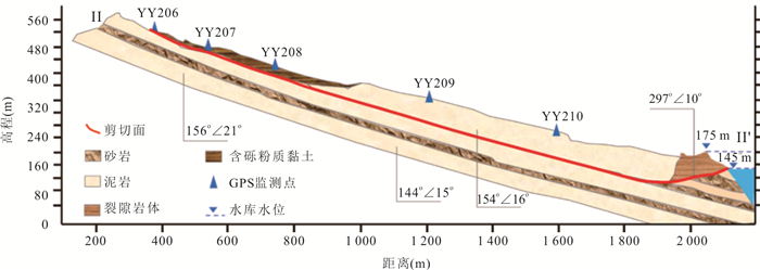
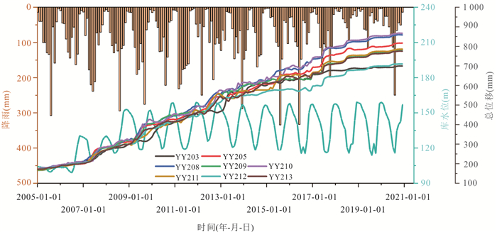
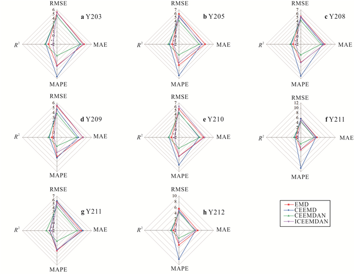
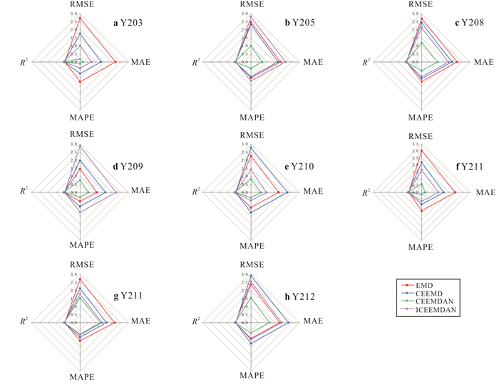
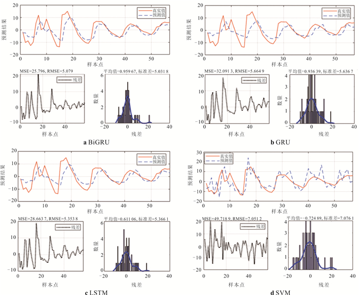
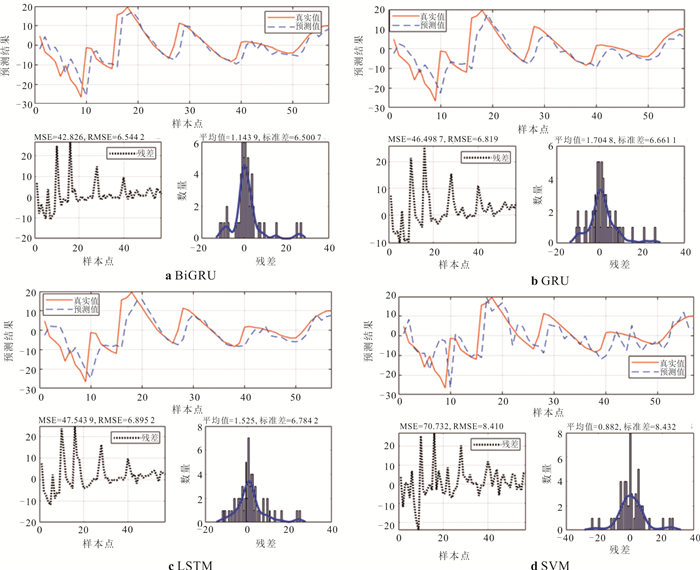
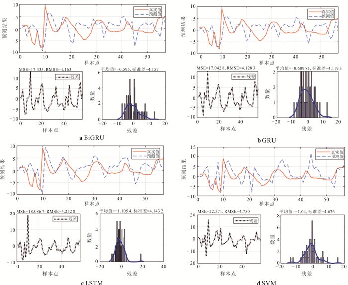
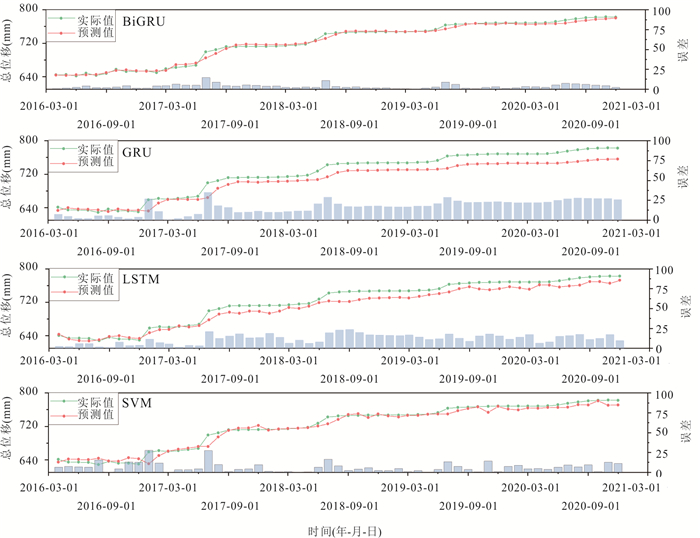
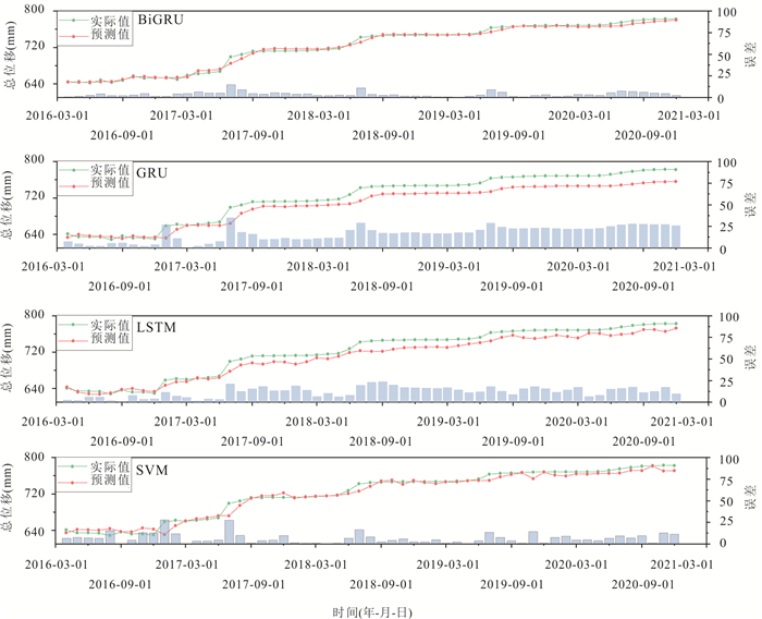
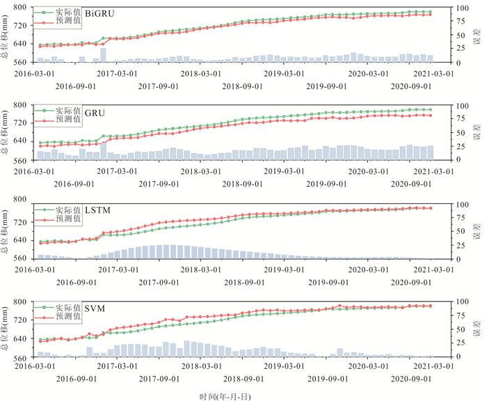
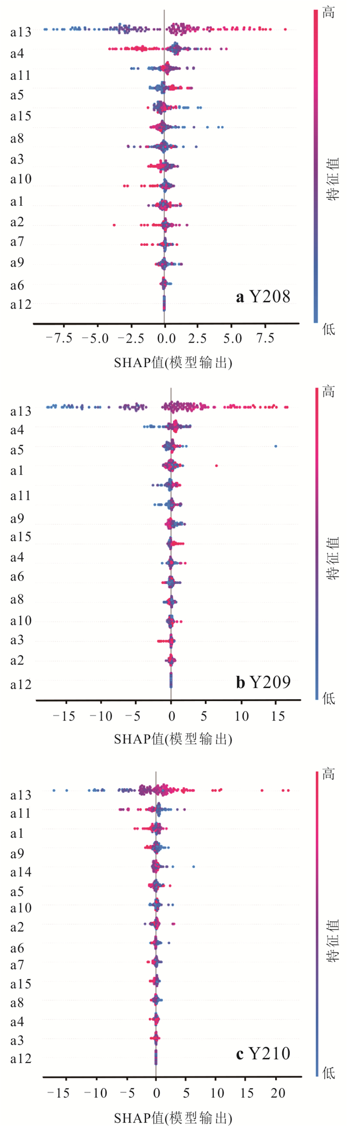
Landslide displacement is a key indicator for evaluating slope stability and implementing early warning measures. However, under the influence of cyclic reservoir water level fluctuations, displacement often exhibits step-like patterns, posing significant challenges for accurate modeling and prediction. To address this, it proposes an interpretable machine learning framework for landslide displacement forecasting. The framework first employs an improved Complete Ensemble Empirical Mode Decomposition with Adaptive Noise (ICEEMDAN) to decompose displacement signals into high-frequency cycles and low-frequency trends, effectively mitigating mode mixing while preserving multi-scale features. Then, a Bidirectional Gated Recurrent Unit (BiGRU) model is used to predict each component, leveraging bidirectional context and a lightweight gating mechanism to capture both long-term dependencies and abrupt changes triggered by rainfall. Finally, SHapley Additive exPlanations (SHAP) are applied to interpret the model outputs, identifying key drivers such as historical and current reservoir levels, cumulative rainfall, and recent displacement trends, with site-specific differences across monitoring points. Case studies demonstrate that ICEEMDAN improves RMSE, MAE, MAPE, and R2 by over 20% compared to traditional decomposition methods (EMD, EEMD, CEEMDAN). The BiGRU model achieves high prediction accuracy (e.g., R2 = 0.992 and MAE = 3.617 mm at YY209), while SHAP enhances the transparency and physical interpretability of the predictions. Overall, the proposed framework combines high accuracy with interpretability, offering a promising approach for reservoir landslide early warning and risk management.
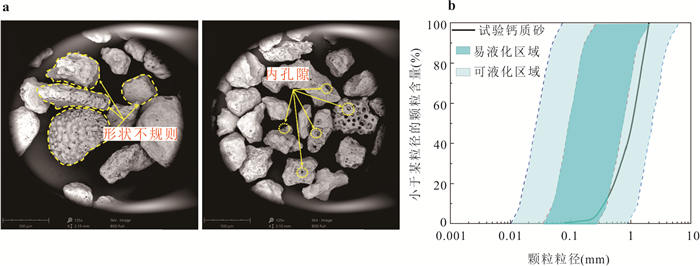
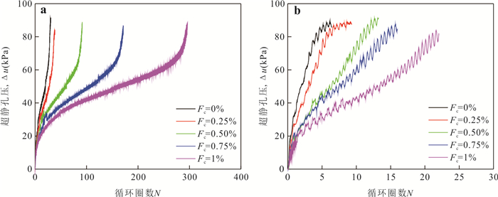
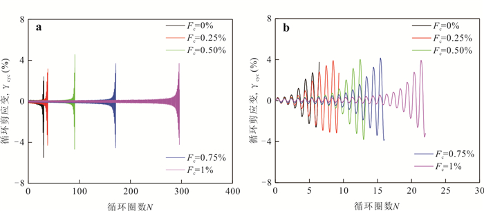
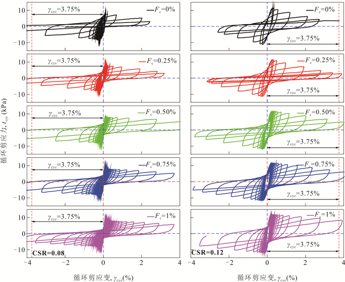
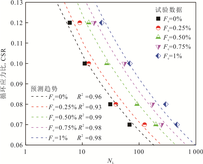
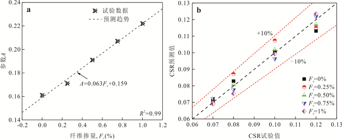
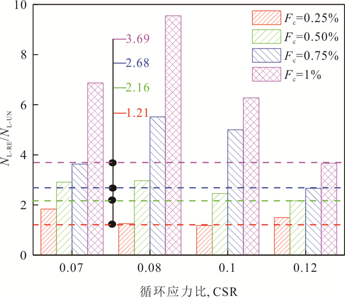
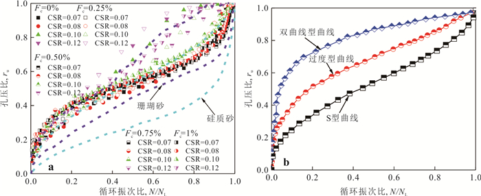
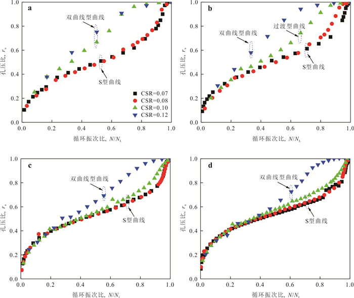
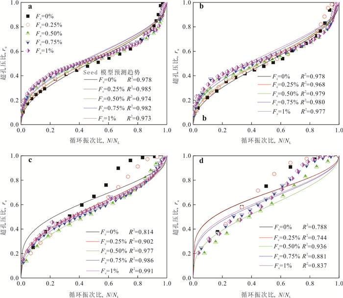
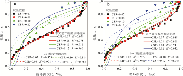
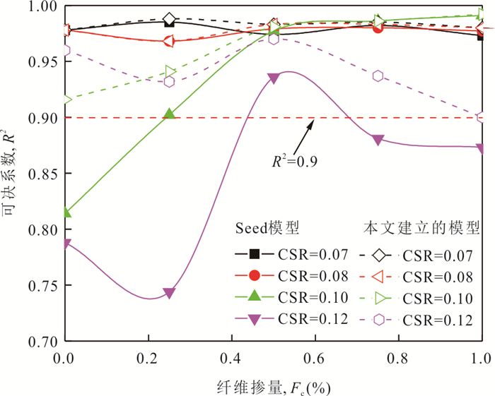
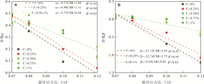
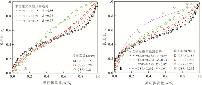
Liquefaction of calcareous sand foundations is a major cause of seismic damage to critical infrastructure,including breakwaters,wharves,and airport runways. Fiber reinforcement,an environmentally friendly geotechnical materials,can effectively improve the liquefaction resistance of calcareous sand and exhibits great promise for island and reef engineering in the South China Sea. In this study,a series of undrained cyclic simple shear tests were conducted to examine the effects of fiber content (Fc) and cyclic stress ratio (CSR) on excess pore pressure,deformation,and liquefaction resistance of fiber-reinforced calcareous sand. A new prediction model for excess pore pressure development of fiber-reinforced calcareous sand was proposed based on the test results. The findings show that increasing Fc significantly reduces the accumulation rates of excess pore pressure and shear strain,thereby enhancing liquefaction resistance,whereas the reinforcement effect weakens as CSR rises. Fiber reinforcement also alters the deformation pattern of calcareous sand during liquefaction and effectively inhibits the occurrence of sharp increase in deformation. Furthermore,the excess pore pressure development in fiber-reinforced calcareous sand differs significantly from that in siliceous sand,and it presents a faster excess pore pressure accumulation rate under the same cyclic ratio,resulting in the traditional Seed model inadequate for accurately capturing its evolution. With increasing CSR,excess pore pressure development pattern shifts from S-shaped to hyperbolic,while higher Fc induces the opposite trend. These results provide important theoretical support for applying fiber reinforcement to liquefaction mitigation in island and reef infrastructures.
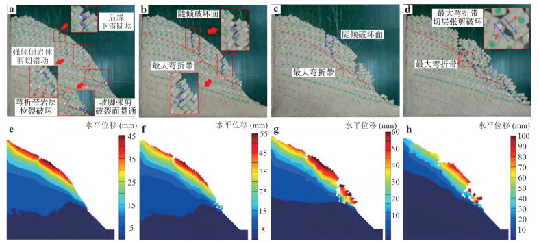
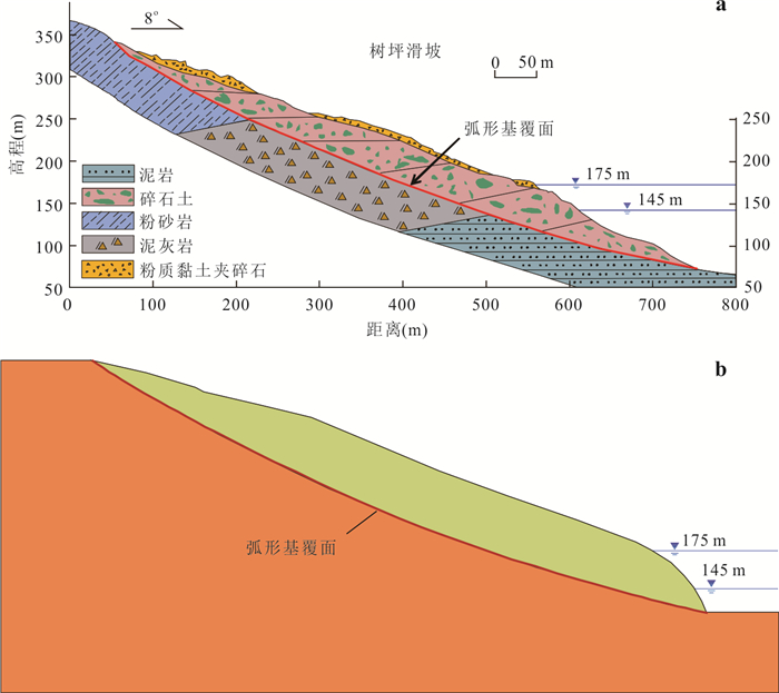
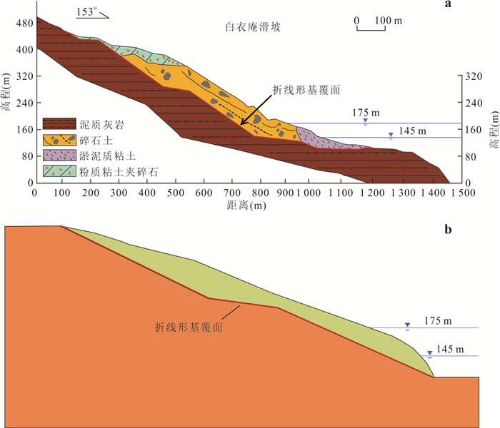
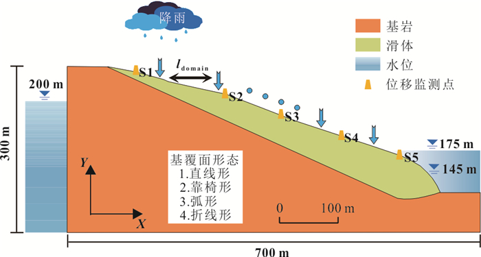
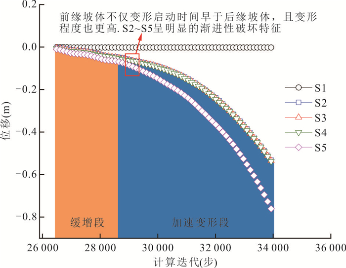
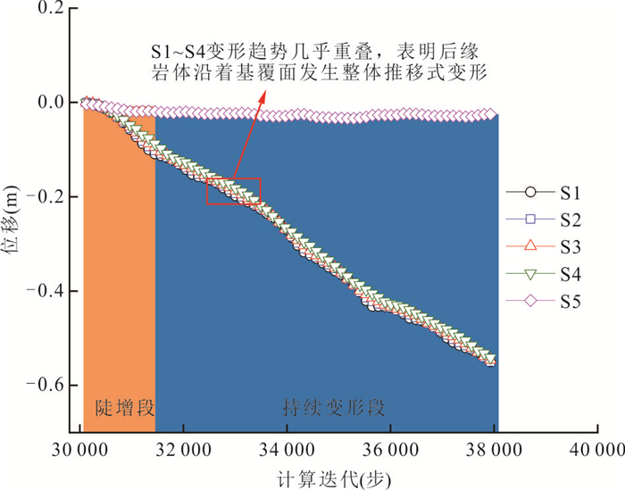
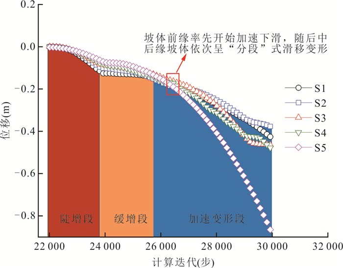
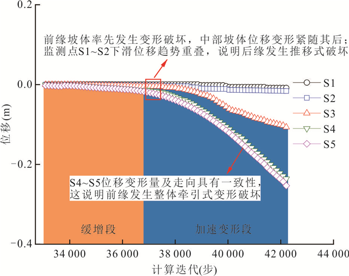
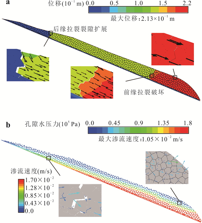
To investigate the instability mechanisms of such landslides with different interface morphology, four typical interface morphology was established based on the geometric characteristics of accumulation landslides in the three gorges reservoir area, namely, line-like shape, arc-like shape, chair-like shape, and step-like shape. Discrete element methods were conducted to elucidate mechanical response laws, failure modes, and instability mechanisms. Key findings reveal that the failure modes are governed by the interface morphology through its control of internal stress distribution. The line-like shape and arc-like shape exhibit typical retrogression failure characteristics, whereas the chair-like shape manifest pronounced progressive deformation, while the step-like shape landslide has the composite failure characteristics. Rainfall primarily drives deformation by elevating groundwater levels in the mid-rear sections, increasing pore water pressure. Conversely, reservoir water level fluctuations redistribute groundwater pressure near the toe, generating outward seepage forces that induce localized retrogressive deformation. These findings provide a scientific basis for analyzing instability mechanisms and designing prevention strategies for analogous accumulation landslides.
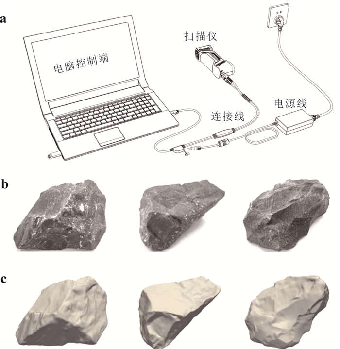
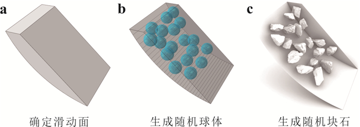
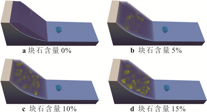
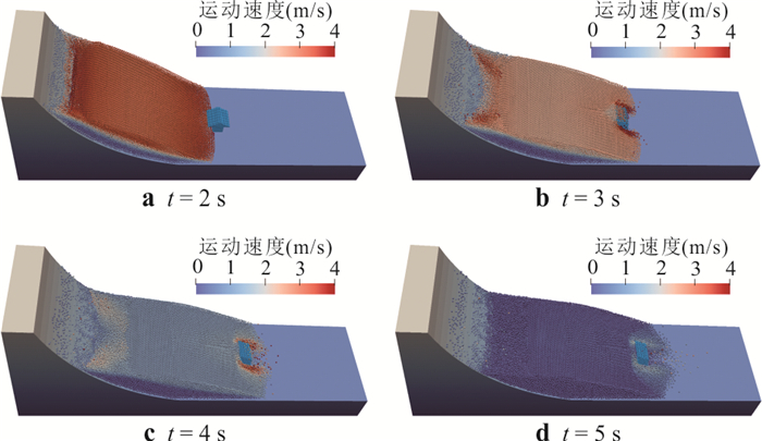
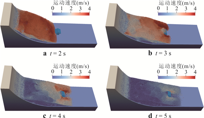
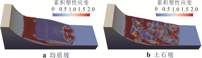
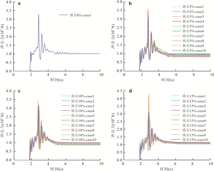
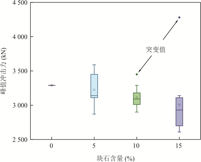
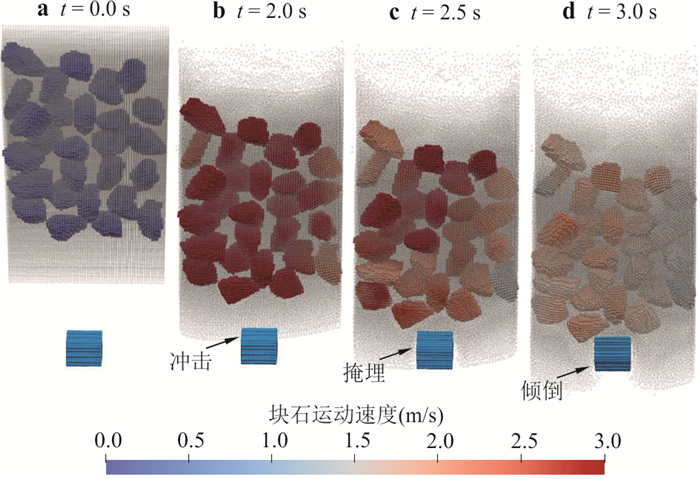
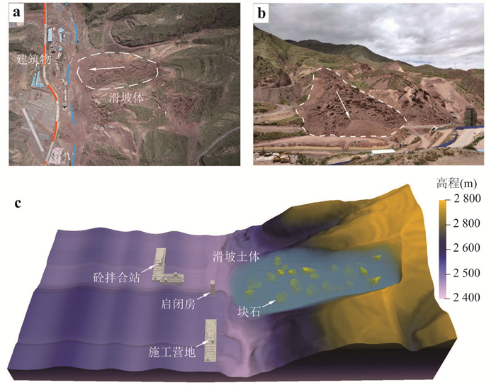
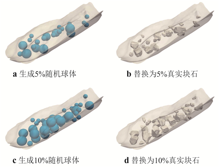
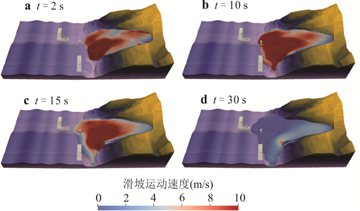
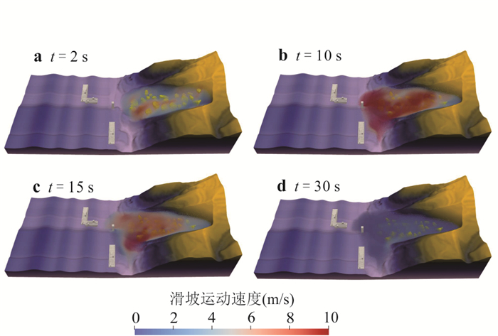
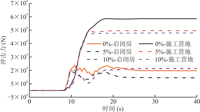
Most natural slopes are composed of soil-rock mixtures, whose large deformation and failure pose severe threats to human safety and infrastructure. To overcome the challenges in high-fidelity modeling and coupled soil-rock mixture interaction analysis, this study develops a high-fidelity 3D modeling technique for soil-rock mixture slopes and proposes an SPH-DEM coupling method to simulate the large deformations. It further analyzes the impact of boulders on the deformation and failure process of the slope and predict the variation of the impact on dam appurtenant structures after the reactivation of the Langjia landslide in Qinghai Province. The results reveal that boulders within the landslide body significantly increasing the landslide velocity, and the content and position of the boulders affect the impact process. Higher boulder content leads to a more pronounced difference in the impact force time-history curve. When boulders collide directly with buildings, the peak impact force increases by about 30% compared to scenarios without boulders. After reactivation, the maximum movement distance of the front edge of the Langjia landslide in Qinghai Province reaches 108 m, with peak impact forces on the intake and construction camp structures reaching 20 times and 4 times their own weight, respectively, making them highly vulnerable to destruction by the landslide. The findings of this study provide valuable insights for disaster prediction and risk analysis of soil-rock mixture landslides.
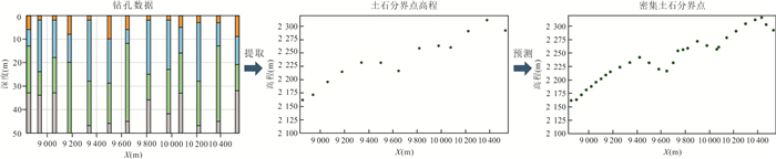
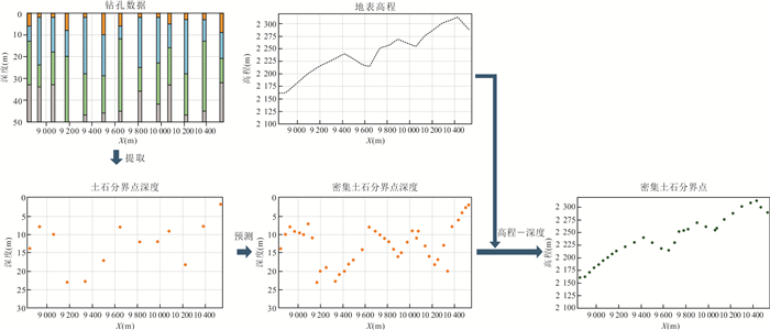
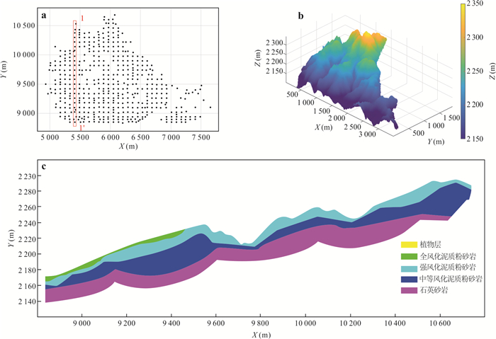
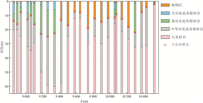
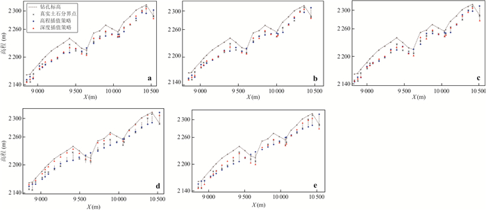
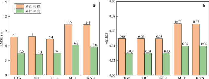
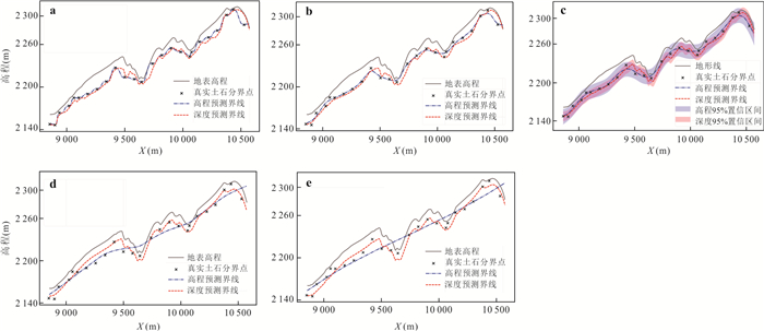
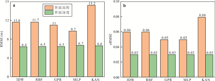
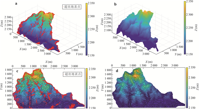
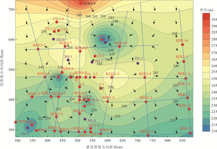
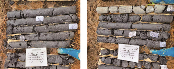
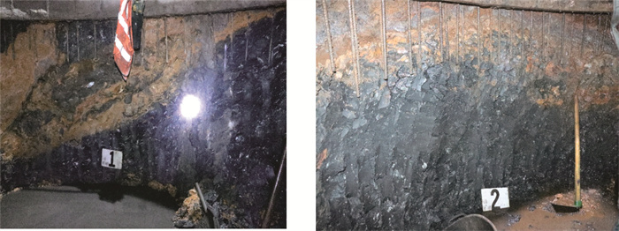
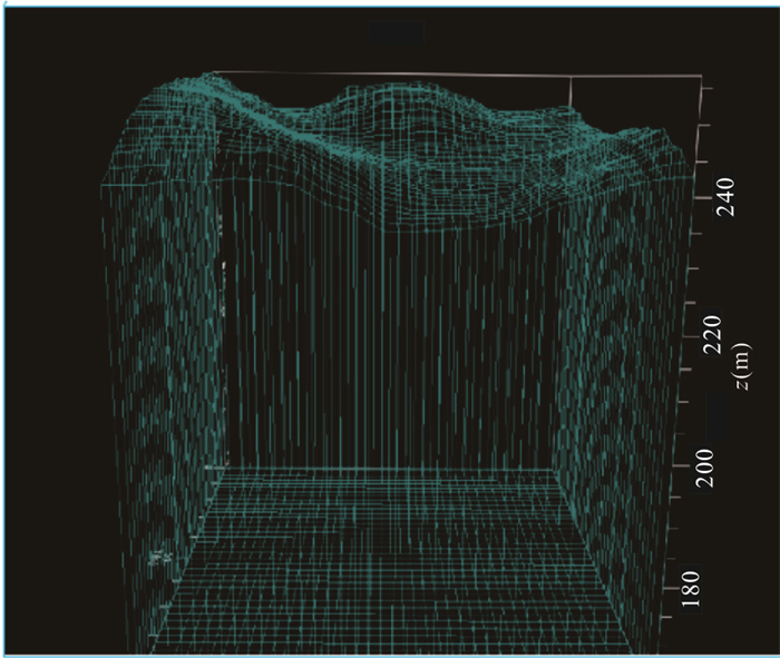
The prediction of the soil-rock interface is crucial for airport construction in mountainous areas. Conventional methods typically rely on borehole data to directly estimate the elevation of the soil-rock interface. However, when topographic variability is pronounced and interface-elevation contrasts are large, the accuracy of such estimates is often insufficient to satisfy engineering requirements. In this paper it introduces an interpolation strategy that incorporates terrain elevation and interface depth. In this framework, the elevation of the soil-rock interface is expressed as the terrain elevation minus the depth of the interface. By shifting the prediction task to estimating interface depth alone, this approach reduces the influence of topographic variability on prediction accuracy. The performance of the proposed strategy is systematically evaluated using various prediction methods, including kernel methods such as inverse distance weighting, radial basis function kernel regression, and Gaussian process regression, as well as neural network approaches (e.g., multilayer perceptron and Kolmogorov-Arnold Networks). Case studies from airport projects in mountainous regions demonstrate that the strategy can be readily integrated with different prediction methods and substantially improves the accuracy of soil-rock interface predictions. The findings provide technical support for airport site selection, earthwork volume estimation, and construction planning in complex terrains.