2024 Vol. 49, No. 5
Display Method:
2024, 49(5): 1565-1583.
doi: 10.3799/dqkx.2022.393
 PDF 19884KB
Abstract:
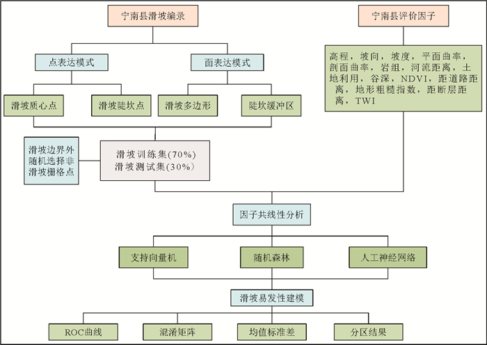
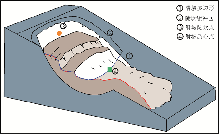
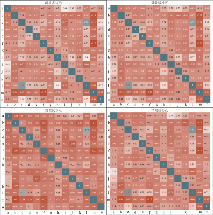
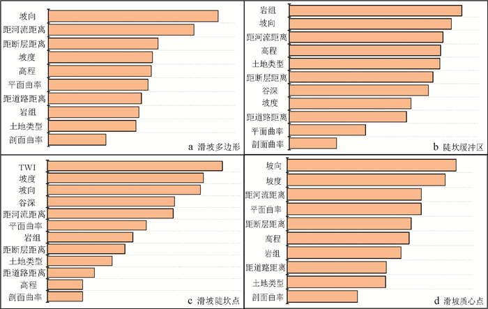
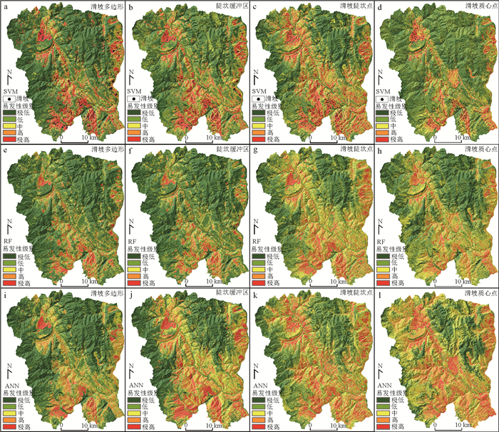
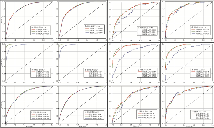
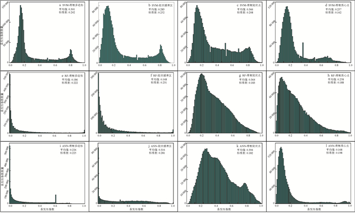
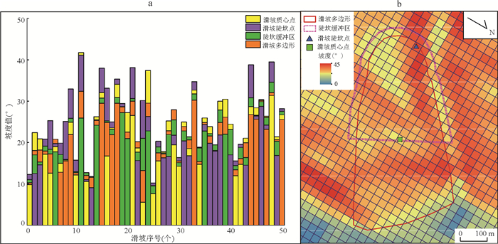
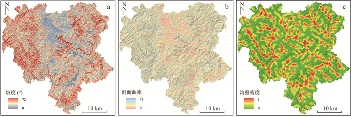
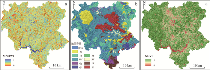
Landslide cataloging modes are usually points and polygons. The location of landslide points and the sampling range of polygons will affect the results of landslide susceptibility evaluation. In order to study the differences in the susceptibility results of different points and polygonal landslide sample sampling strategies, taking Ningnan County, Sichuan Province as an example, landslide polygons and landslide steep sill buffer zones were used to compare the susceptibility evaluation of different polygon expression patterns. The influence of landslide sill point and landslide mass center point was used to compare the influence of different point expression patterns on susceptibility evaluation, and three evaluation models were selected, namely, support vector machine (SVM), random forest (RF) and artificial neural network (ANN). Landslide susceptibility modeling was performed, and differences in modeling were analyzed using ROC curve, mean, and standard deviation. The results are as follows: (1) When the landslide samples are in the polygonal expression mode, the evaluation effect of the steep sill buffer zone is better than that of the landslide polygon. When the landslide sample is in a point expression mode, the evaluation effect of the landslide mass center point is better than that of the landslide steep point. (2) The susceptibility evaluation effect of the RF model is better under different sampling strategies, and the susceptibility results based on the RF model under different sampling strategies are also less different, and have better generalization ability than the SVM and ANN models. (3) The discrete factor is the main factor leading to the difference in the susceptibility results of the sampling strategy under the point expression pattern. Compared with the landslide polygon, the sampling strategy of the steep sill buffer preserves the spatial information of discrete environmental factors such as rock formations, so the evaluation effect is better. It can be seen that using refined terrain features such as landslide steep ridge areas as landslide sampling methods at the county scale can improve the accuracy of susceptibility evaluation.
Landslide cataloging modes are usually points and polygons. The location of landslide points and the sampling range of polygons will affect the results of landslide susceptibility evaluation. In order to study the differences in the susceptibility results of different points and polygonal landslide sample sampling strategies, taking Ningnan County, Sichuan Province as an example, landslide polygons and landslide steep sill buffer zones were used to compare the susceptibility evaluation of different polygon expression patterns. The influence of landslide sill point and landslide mass center point was used to compare the influence of different point expression patterns on susceptibility evaluation, and three evaluation models were selected, namely, support vector machine (SVM), random forest (RF) and artificial neural network (ANN). Landslide susceptibility modeling was performed, and differences in modeling were analyzed using ROC curve, mean, and standard deviation. The results are as follows: (1) When the landslide samples are in the polygonal expression mode, the evaluation effect of the steep sill buffer zone is better than that of the landslide polygon. When the landslide sample is in a point expression mode, the evaluation effect of the landslide mass center point is better than that of the landslide steep point. (2) The susceptibility evaluation effect of the RF model is better under different sampling strategies, and the susceptibility results based on the RF model under different sampling strategies are also less different, and have better generalization ability than the SVM and ANN models. (3) The discrete factor is the main factor leading to the difference in the susceptibility results of the sampling strategy under the point expression pattern. Compared with the landslide polygon, the sampling strategy of the steep sill buffer preserves the spatial information of discrete environmental factors such as rock formations, so the evaluation effect is better. It can be seen that using refined terrain features such as landslide steep ridge areas as landslide sampling methods at the county scale can improve the accuracy of susceptibility evaluation.
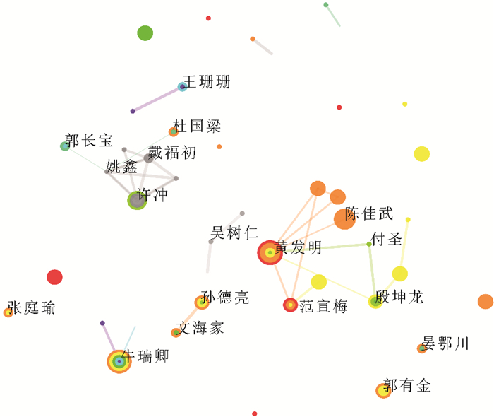
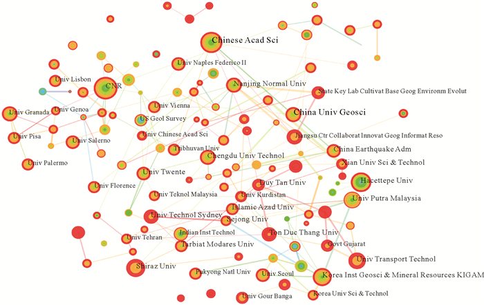
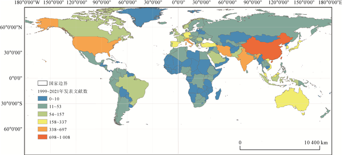
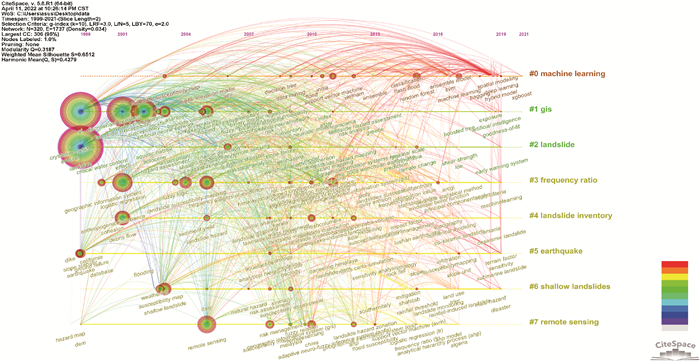
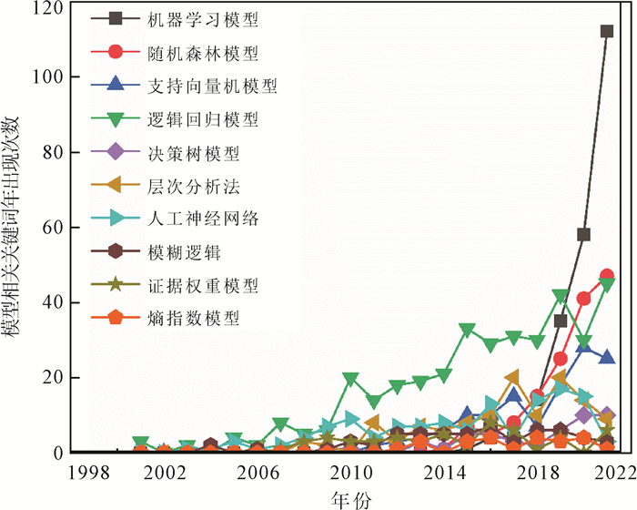
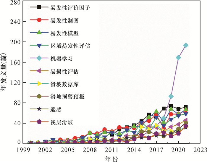
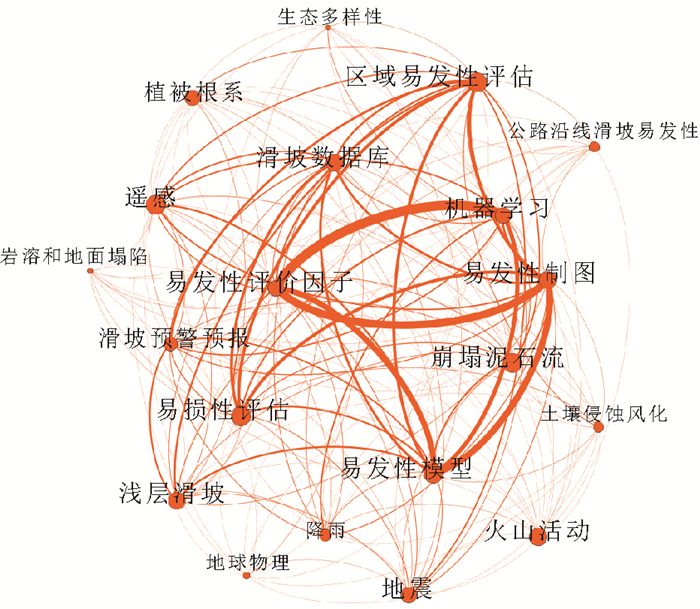
Literature Review and Research Progress of Landslide Susceptibility Mapping Based on Knowledge Graph
2024, 49(5): 1584-1606.
doi: 10.3799/dqkx.2023.058
Abstract:
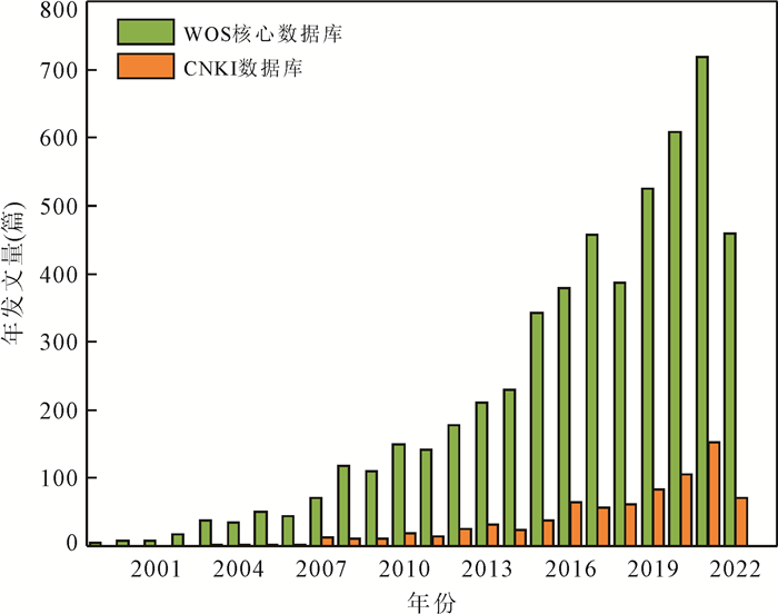
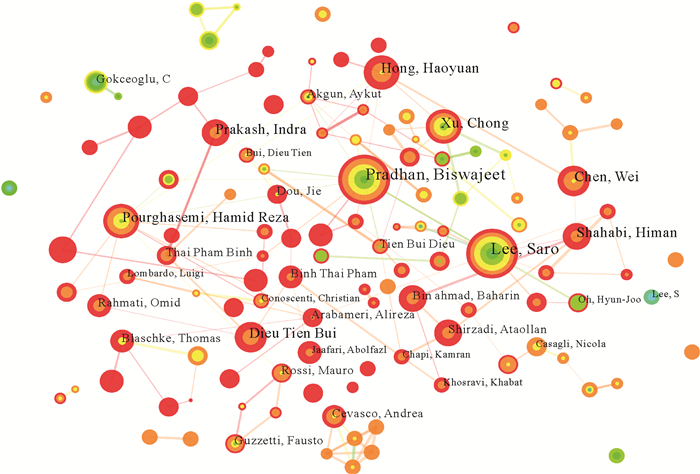
Landslide susceptibility mapping (LSM) is the foundation and critical part of landslide risk assessment. The bibliometric analysis of LSM literature can be applied to quantitatively analyze the research progress and development trend. The result will provide references for geological hazard risk assessment in China. In this study, based on the Web of Science and CNKI databases, the CiteSpace visual knowledge graph analysis tool has been used to carry out bibliometric analysis of LSM literature from 1985 to 2022. Moreover, the LDA analysis has been conducted on the abstract to subdivide the research in this field. The results show that: (1) LSM is still a research hotspot at present. In China, there are a large number of studies and international cooperation about LSM. (2) Four of the top 10 authors in the number of published papers on LSM are from China. The institution that has published the most papers on LSM is the Chinese Academy of Sciences. The Chinese Journal of Geological Hazard and Control is the most popular Chinese journal and the Natural Hazardsis the most popular English journals to publish LSM papers. The research on the subject of LSM has been substantially funded by the National Natural Science Foundation of China and the National Land and Resources Survey Project. (3) In the past five years, machine learning models (including deep learning, etc.) have been widely used as the most popular LSM models. (4) In order to achieve the simplification and intelligence of landslide susceptibility modeling and to improve the accuracy and practicability of the LSM results, the following parts of LSM, including the landslide inventory, conditioning factors, assessment unit, assessment model, connection methods and accuracy verification, need to be deeply explored in further studies.
Landslide susceptibility mapping (LSM) is the foundation and critical part of landslide risk assessment. The bibliometric analysis of LSM literature can be applied to quantitatively analyze the research progress and development trend. The result will provide references for geological hazard risk assessment in China. In this study, based on the Web of Science and CNKI databases, the CiteSpace visual knowledge graph analysis tool has been used to carry out bibliometric analysis of LSM literature from 1985 to 2022. Moreover, the LDA analysis has been conducted on the abstract to subdivide the research in this field. The results show that: (1) LSM is still a research hotspot at present. In China, there are a large number of studies and international cooperation about LSM. (2) Four of the top 10 authors in the number of published papers on LSM are from China. The institution that has published the most papers on LSM is the Chinese Academy of Sciences. The Chinese Journal of Geological Hazard and Control is the most popular Chinese journal and the Natural Hazardsis the most popular English journals to publish LSM papers. The research on the subject of LSM has been substantially funded by the National Natural Science Foundation of China and the National Land and Resources Survey Project. (3) In the past five years, machine learning models (including deep learning, etc.) have been widely used as the most popular LSM models. (4) In order to achieve the simplification and intelligence of landslide susceptibility modeling and to improve the accuracy and practicability of the LSM results, the following parts of LSM, including the landslide inventory, conditioning factors, assessment unit, assessment model, connection methods and accuracy verification, need to be deeply explored in further studies.

2024, 49(5): 1607-1618.
doi: 10.3799/dqkx.2022.357
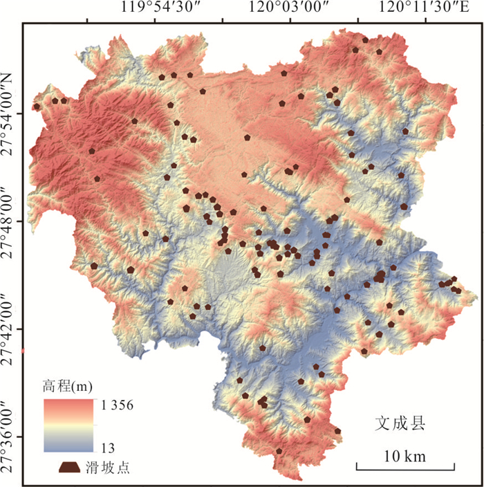
Abstract:
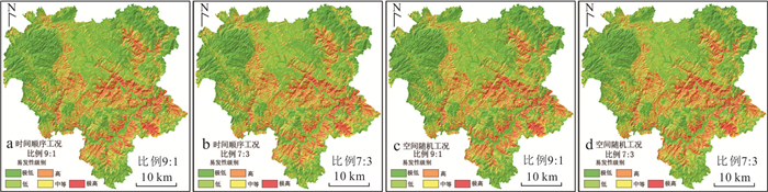
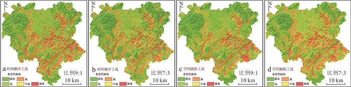
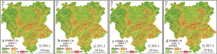
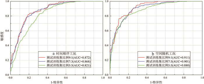
In most of the landslide susceptibility prediction (LSP) models, the landslide-non landslide spatial datasets are divided into training/testing datasets according to the principle of spatial random, however, this spatial randomness division inevitably introduces uncertainties into LSP modelling. Theoretically, LSP modelling is based on past landslide inventories to predict the spatial probability of future landslides, which has significant time series characteristics rather than only spatial random characteristics. Therefore, we believe that it is necessary to divide spatial datasets into the model training/testing datasets based on the time series of landslide occurrence. Taking Wencheng County in China as an example, 11 types of environmental factors and 128 time-accurate landslides are obtained; Then, the landslide and non-landslide samples connected with environmental factors are divided into two different types of training/testing datasets according to the principles of landslide time series and spatial random, respectively. The division ratios of training/testing datasets are set as 9∶1, 8∶2, 7∶3, 6∶4 and 5∶5, respectively, to avoid the influences of different ratios on the LSP results. Thus, the training/testing datasets under 10 combined working conditions are obtained. Finally, several typical machine learning models, such as Support Vector Machine (SVM), Multi-Layer Perceptron (MLP) and Random Forest (RF), are then trained and tested to perform LSP and analyze their uncertainties. Results show that: (1) The LSP uncertainties performed by the time series-based SVM, MLP and RF models are slightly lower than those by spatial random-based models, which verifies the feasibility of dividing by time series; (2) The time series division of training/testing datasets is actually a "deterministic" case among the spatial random division, which is more consistent with the actual situation of landslides. Of course, it is also feasible to carry out spatial random division for training and testing datasets when lacking landslide occurrence time.
In most of the landslide susceptibility prediction (LSP) models, the landslide-non landslide spatial datasets are divided into training/testing datasets according to the principle of spatial random, however, this spatial randomness division inevitably introduces uncertainties into LSP modelling. Theoretically, LSP modelling is based on past landslide inventories to predict the spatial probability of future landslides, which has significant time series characteristics rather than only spatial random characteristics. Therefore, we believe that it is necessary to divide spatial datasets into the model training/testing datasets based on the time series of landslide occurrence. Taking Wencheng County in China as an example, 11 types of environmental factors and 128 time-accurate landslides are obtained; Then, the landslide and non-landslide samples connected with environmental factors are divided into two different types of training/testing datasets according to the principles of landslide time series and spatial random, respectively. The division ratios of training/testing datasets are set as 9∶1, 8∶2, 7∶3, 6∶4 and 5∶5, respectively, to avoid the influences of different ratios on the LSP results. Thus, the training/testing datasets under 10 combined working conditions are obtained. Finally, several typical machine learning models, such as Support Vector Machine (SVM), Multi-Layer Perceptron (MLP) and Random Forest (RF), are then trained and tested to perform LSP and analyze their uncertainties. Results show that: (1) The LSP uncertainties performed by the time series-based SVM, MLP and RF models are slightly lower than those by spatial random-based models, which verifies the feasibility of dividing by time series; (2) The time series division of training/testing datasets is actually a "deterministic" case among the spatial random division, which is more consistent with the actual situation of landslides. Of course, it is also feasible to carry out spatial random division for training and testing datasets when lacking landslide occurrence time.
2024, 49(5): 1619-1635.
doi: 10.3799/dqkx.2022.407
Abstract:
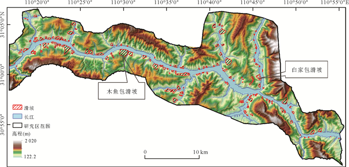
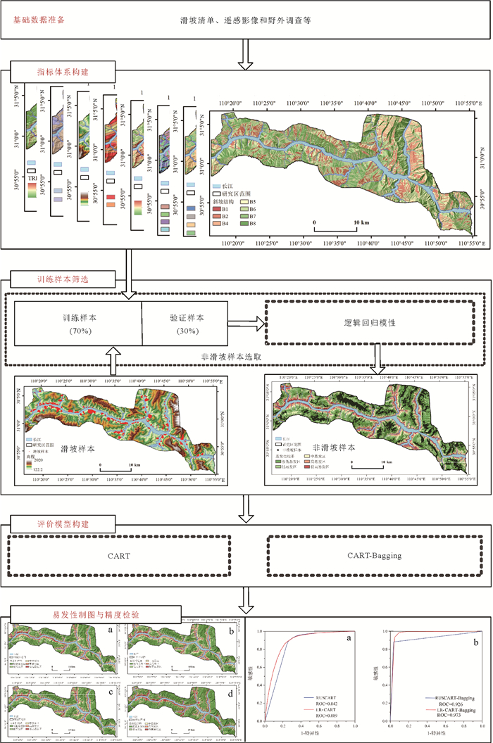
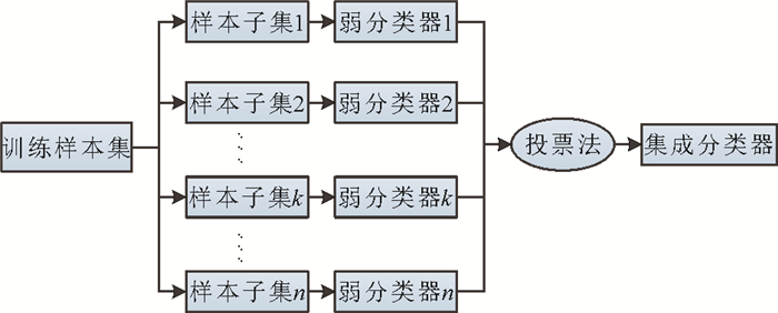
Landslide susceptibility evaluation is important for its early warning and forecasting and risk management.To address the problems of a random selection of non-landslide samples and low accuracy of individual classifiers in modeling by machine learning techniques, a coupled multi-model regional landslide susceptibility modeling framework is proposed.Taking the Zigui-Badong section of the Three Gorges reservoir area as an example, 12 factors such as elevation and slope were selected to construct an evaluation index system, and the information quantity method was applied to quantify the influence degree of each factor on landslide spatial development. 70% of the landslides were randomly selected as training samples and the remaining 30% as validation samples; the Logistic Regression model (LR) was applied to produce an initial susceptibility zoning map of the study area and to determine the constraint range for random sampling of non-landslides. Subsequently, a single Classification and Regression Tree (LR-CART and No-CART) and combined Classification and Regression Tree-Bagging model (LR-CART-Bagging and No-CART-Bagging) were applied to model landslide susceptibility using randomly selected non-landslide samples under the constrained and unconstrained conditions of LR model, respectively, and multiple metrics were applied for accuracy assessment.The results show that elevation and water system are the main controlling factors for landslide development; the accuracy of the LR-CART-Bagging model is 0.973, higher than 0.889 of the LR-CART model; compared with No-CART and No-CART-Bagging models, the accuracy of LR-CART and LR-CART-Bagging models is improved by 0.057 and 0.047, respectively.LR model can effectively constrain the selection range of non-landslide samples and improve the quality of sample selection; the CART-Bagging model integrates the advantages of machine learning and ensemble learning with better prediction performance, and the proposed LR-CART-Bagging model is an accurate and reliable method for landslide susceptibility modeling.
Landslide susceptibility evaluation is important for its early warning and forecasting and risk management.To address the problems of a random selection of non-landslide samples and low accuracy of individual classifiers in modeling by machine learning techniques, a coupled multi-model regional landslide susceptibility modeling framework is proposed.Taking the Zigui-Badong section of the Three Gorges reservoir area as an example, 12 factors such as elevation and slope were selected to construct an evaluation index system, and the information quantity method was applied to quantify the influence degree of each factor on landslide spatial development. 70% of the landslides were randomly selected as training samples and the remaining 30% as validation samples; the Logistic Regression model (LR) was applied to produce an initial susceptibility zoning map of the study area and to determine the constraint range for random sampling of non-landslides. Subsequently, a single Classification and Regression Tree (LR-CART and No-CART) and combined Classification and Regression Tree-Bagging model (LR-CART-Bagging and No-CART-Bagging) were applied to model landslide susceptibility using randomly selected non-landslide samples under the constrained and unconstrained conditions of LR model, respectively, and multiple metrics were applied for accuracy assessment.The results show that elevation and water system are the main controlling factors for landslide development; the accuracy of the LR-CART-Bagging model is 0.973, higher than 0.889 of the LR-CART model; compared with No-CART and No-CART-Bagging models, the accuracy of LR-CART and LR-CART-Bagging models is improved by 0.057 and 0.047, respectively.LR model can effectively constrain the selection range of non-landslide samples and improve the quality of sample selection; the CART-Bagging model integrates the advantages of machine learning and ensemble learning with better prediction performance, and the proposed LR-CART-Bagging model is an accurate and reliable method for landslide susceptibility modeling.

2024, 49(5): 1636-1653.
doi: 10.3799/dqkx.2022.453
Abstract:
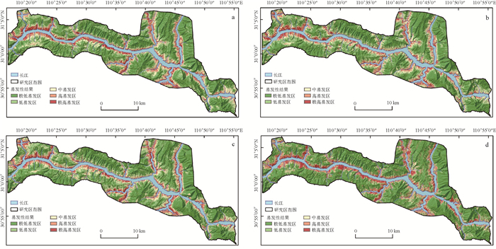
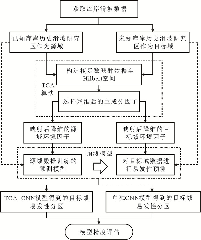
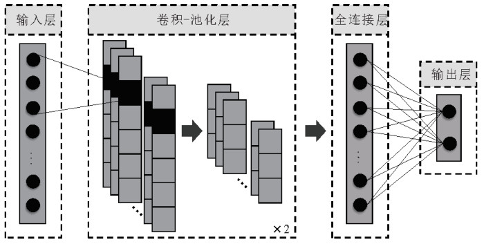
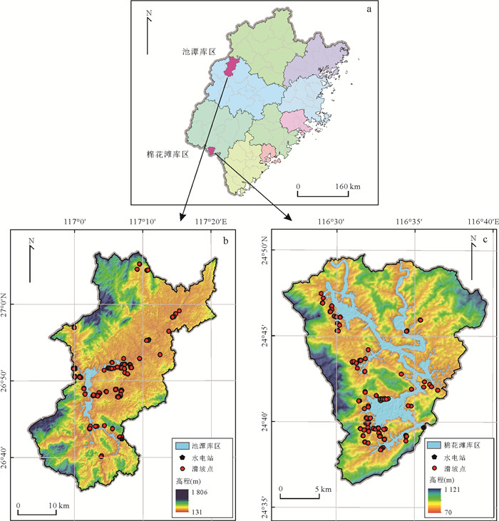
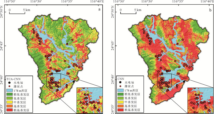
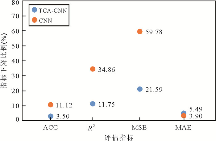
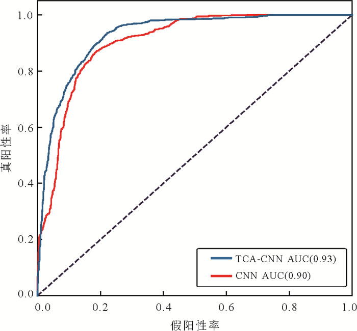
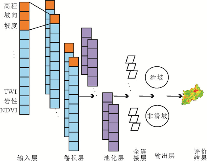
It is crucial to create a "migratable" landslide susceptibility model considering the time-consuming process of recording landslides. However, a sample set of all known landslide data areas must be used in forecasting the susceptibility of unsampled regions adequately. In this paper, we attempt to develop a TCA-CNN model to enable trans-regional landslide susceptibility evaluation, which is based on the adaption domain of transfer learning by integrating the transfer component analysis (TCA) with deep learning convolutional neural network (CNN). The spatial database of landslides is constructed by extracting 11 environmental factors of the reservoir bank area, then the Mianhuatan reservoir area without samples is then predicted using the susceptibility model from the Chitan reservoir area with samples. The results show that: (1) The maximum mean discrepancy (MMD) of data from different study areas treated by TCA decreased significantly (0.022), and the data is approximately identically distributed; (2) The trans-regional prediction accuracy by the TCA-CNN model is 0.854, which is higher than that of the CNN model (0.791). And it can be verified that the proportion of landslide frequency falling into the high/extremely-high susceptibility interval is the highest (89.1%) in the historical landslide; (3) The area under the receiver operating characteristic (ROC) curve of the TCA-CNN model is 0.93, which is higher than that of the CNN model (0.90). It's obvious that the TCA-CNN model can effectively use the samples data of the modeling area to realize the susceptibility evaluation of the unsampled area. Compared with the traditional machine model, TCA-CNN model has higher and more stable prediction accuracy and stronger generalization ability in cross-region prediction.
It is crucial to create a "migratable" landslide susceptibility model considering the time-consuming process of recording landslides. However, a sample set of all known landslide data areas must be used in forecasting the susceptibility of unsampled regions adequately. In this paper, we attempt to develop a TCA-CNN model to enable trans-regional landslide susceptibility evaluation, which is based on the adaption domain of transfer learning by integrating the transfer component analysis (TCA) with deep learning convolutional neural network (CNN). The spatial database of landslides is constructed by extracting 11 environmental factors of the reservoir bank area, then the Mianhuatan reservoir area without samples is then predicted using the susceptibility model from the Chitan reservoir area with samples. The results show that: (1) The maximum mean discrepancy (MMD) of data from different study areas treated by TCA decreased significantly (0.022), and the data is approximately identically distributed; (2) The trans-regional prediction accuracy by the TCA-CNN model is 0.854, which is higher than that of the CNN model (0.791). And it can be verified that the proportion of landslide frequency falling into the high/extremely-high susceptibility interval is the highest (89.1%) in the historical landslide; (3) The area under the receiver operating characteristic (ROC) curve of the TCA-CNN model is 0.93, which is higher than that of the CNN model (0.90). It's obvious that the TCA-CNN model can effectively use the samples data of the modeling area to realize the susceptibility evaluation of the unsampled area. Compared with the traditional machine model, TCA-CNN model has higher and more stable prediction accuracy and stronger generalization ability in cross-region prediction.
2024, 49(5): 1654-1664.
doi: 10.3799/dqkx.2023.113
Abstract:
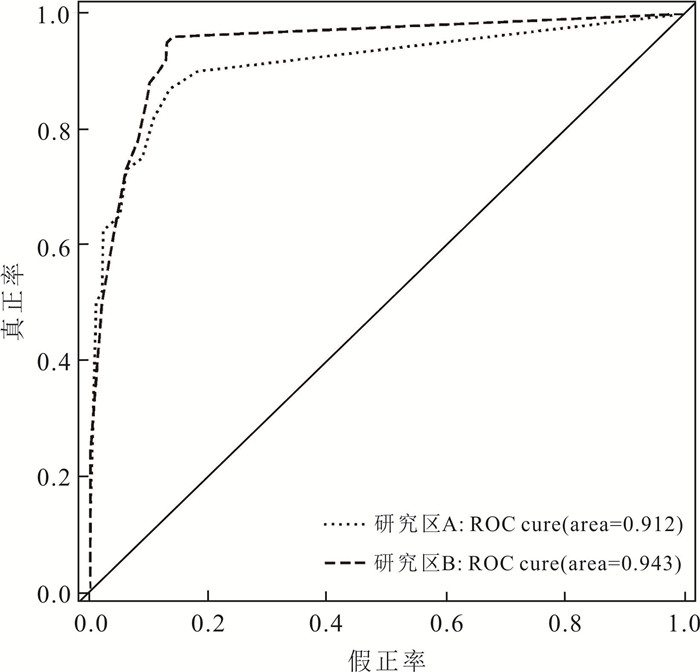
In order to solve the problems of insufficient landslide catalog data in the process of landslide susceptibility evaluation, and low model accuracy due to subjective or random selection of non-landslide raster cells, 12 evaluation factors were selected from the aspects of topography and geomorphology, geological conditions, hydrometeorological conditions and human engineering activities to construct a landslide evaluation system for Xianrendong National Nature Reserve in southern Liaoning Province in this paper; Furthermore, the imbalance of sample categories between landslide and non-landslide was solved based on SMOTETomek comprehensive sampling method, and then a dataset of landslide susceptibility evaluation was established; Finally, for the nonlinear landslide data in the east and west sides of the study area (zones A and B), the convolutional neural networks (CNN) model was constructed to evaluate the landslide susceptibility, and the distribution map of landslide susceptibility in the study area was accurately drawn. The results show that the CNN model had good adaptability, and the zoning map of landslide susceptibility shows a reasonable spatial distribution. The AUC area of the test set in part A and part B of the study area was 91.2% and 94.3%, respectively.70% of landslides were distributed in higher and above grade prone areas, and 68.7% of non-landslides were distributed in lower and below grade prone areas. The high prone area of landslide is mainly located in the area of Maoling Beigou Mountain in the northeast of the study area, the northern mountainous area of the Bingyugou Scenic Area, and the coastal area of the Biliuhe Reservoir. The research results can provide an important scientific basis for the planning of geological disaster prevention and control, and the formulation of emergency plans in Xianrendong National Nature Reserve in southern Liaoning Province.
In order to solve the problems of insufficient landslide catalog data in the process of landslide susceptibility evaluation, and low model accuracy due to subjective or random selection of non-landslide raster cells, 12 evaluation factors were selected from the aspects of topography and geomorphology, geological conditions, hydrometeorological conditions and human engineering activities to construct a landslide evaluation system for Xianrendong National Nature Reserve in southern Liaoning Province in this paper; Furthermore, the imbalance of sample categories between landslide and non-landslide was solved based on SMOTETomek comprehensive sampling method, and then a dataset of landslide susceptibility evaluation was established; Finally, for the nonlinear landslide data in the east and west sides of the study area (zones A and B), the convolutional neural networks (CNN) model was constructed to evaluate the landslide susceptibility, and the distribution map of landslide susceptibility in the study area was accurately drawn. The results show that the CNN model had good adaptability, and the zoning map of landslide susceptibility shows a reasonable spatial distribution. The AUC area of the test set in part A and part B of the study area was 91.2% and 94.3%, respectively.70% of landslides were distributed in higher and above grade prone areas, and 68.7% of non-landslides were distributed in lower and below grade prone areas. The high prone area of landslide is mainly located in the area of Maoling Beigou Mountain in the northeast of the study area, the northern mountainous area of the Bingyugou Scenic Area, and the coastal area of the Biliuhe Reservoir. The research results can provide an important scientific basis for the planning of geological disaster prevention and control, and the formulation of emergency plans in Xianrendong National Nature Reserve in southern Liaoning Province.
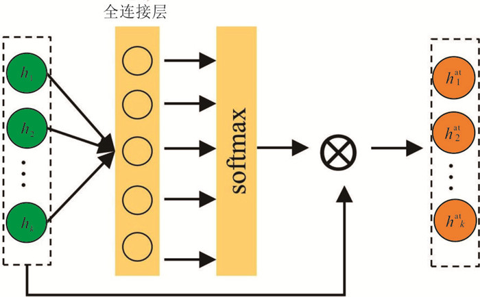
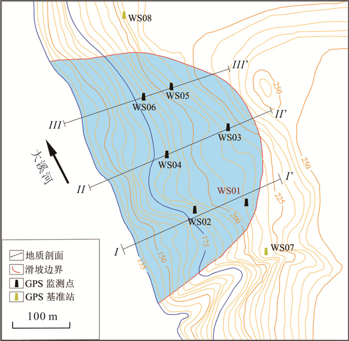
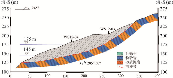
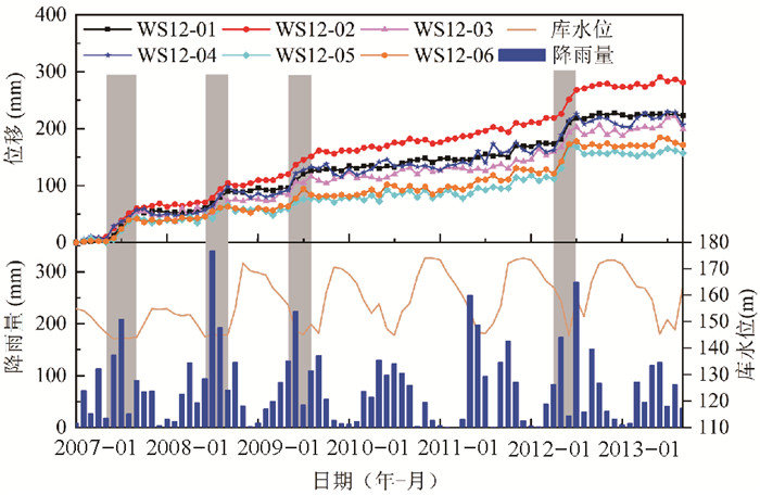
Landslide Displacement Prediction Based on a Deep Learning Model Considering the Attention Mechanism
2024, 49(5): 1665-1678.
doi: 10.3799/dqkx.2022.306
Abstract:
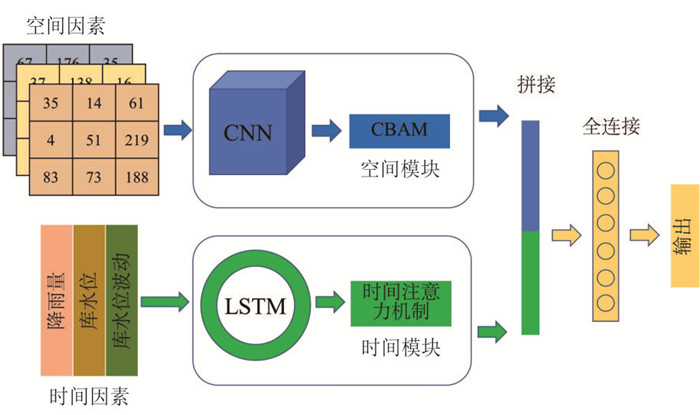
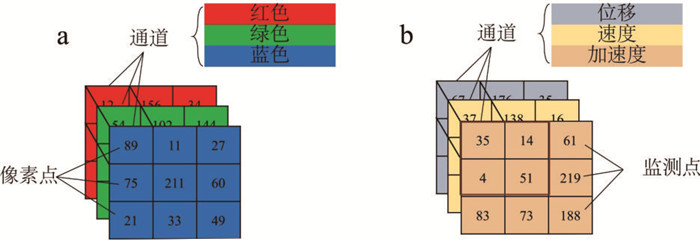
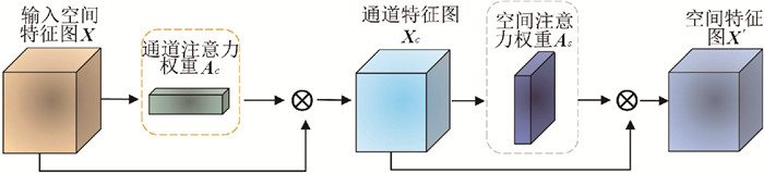
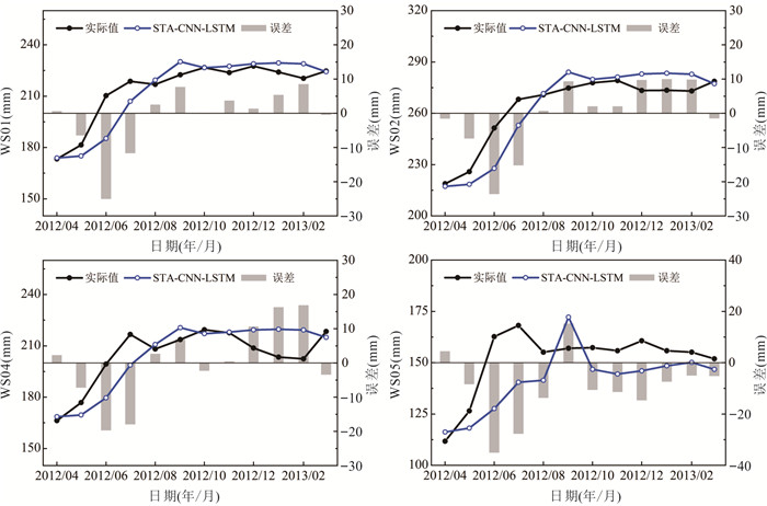
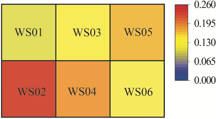
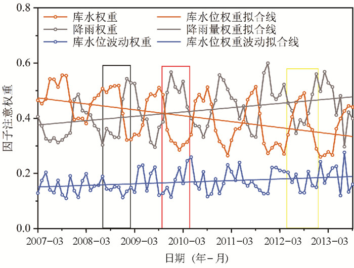
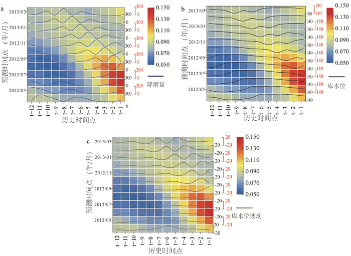
Accurate displacement prediction plays an important role in landslide early warning. However, the majority of the existing data-driven models focus on single-point modeling based on time series data which cannot consider the deformation correlation in the whole slope. To overcome this drawback, this study proposed a spatial-temporal attention (STA) mechanism-based deep learning model which combined the convolutional neural network (CNN) with the long short-term memory (LSTM) neural network. A convolutional block attention module (CBAM) combined with CNN was developed to extract the spatial deformation characteristics of the slope. A temporal attention module and LSTM model were used to learn the significant historical information from the input external conditions time series data. The model also allowed to output the tempo-spatial attention weights to reveal the tempo-spatial characteristics of landslide deformation. The Paotongwan landslide with step-like behavior displacement in the Three Gorges Reservoir Area (TGRA) of China was used to validate the model performance. The results show that, the root mean square error (RMSE) and the mean average percentage error (MAPE) of the STA-CNN-LSTM model decreased 9.28% and 13.88%, respectively, compared with grey wolf optimization optimized support vector machine (GWO-SVM). The attention weight results calculated by STA-CNN-LSTM demonstrate that rainfall had a larger impact on the deformation of the Paotongwan landslide at the beginning of the monitoring while the influence of reservoir water level decreased with ongoing of the monitoring.
Accurate displacement prediction plays an important role in landslide early warning. However, the majority of the existing data-driven models focus on single-point modeling based on time series data which cannot consider the deformation correlation in the whole slope. To overcome this drawback, this study proposed a spatial-temporal attention (STA) mechanism-based deep learning model which combined the convolutional neural network (CNN) with the long short-term memory (LSTM) neural network. A convolutional block attention module (CBAM) combined with CNN was developed to extract the spatial deformation characteristics of the slope. A temporal attention module and LSTM model were used to learn the significant historical information from the input external conditions time series data. The model also allowed to output the tempo-spatial attention weights to reveal the tempo-spatial characteristics of landslide deformation. The Paotongwan landslide with step-like behavior displacement in the Three Gorges Reservoir Area (TGRA) of China was used to validate the model performance. The results show that, the root mean square error (RMSE) and the mean average percentage error (MAPE) of the STA-CNN-LSTM model decreased 9.28% and 13.88%, respectively, compared with grey wolf optimization optimized support vector machine (GWO-SVM). The attention weight results calculated by STA-CNN-LSTM demonstrate that rainfall had a larger impact on the deformation of the Paotongwan landslide at the beginning of the monitoring while the influence of reservoir water level decreased with ongoing of the monitoring.
2024, 49(5): 1679-1691.
doi: 10.3799/dqkx.2022.361
Abstract:
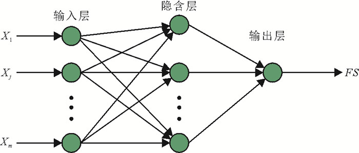
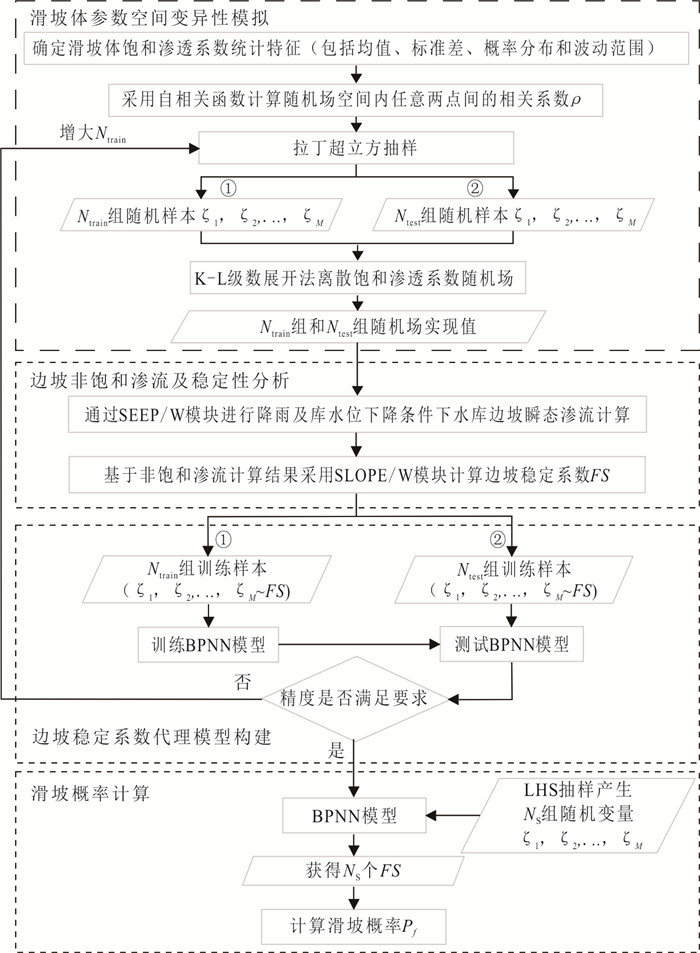
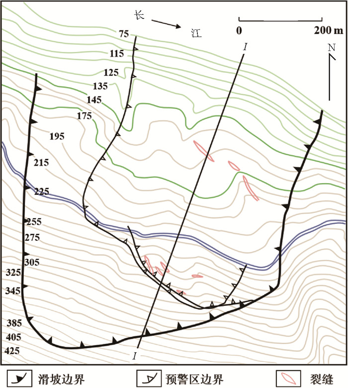
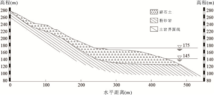
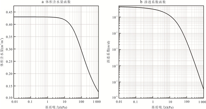
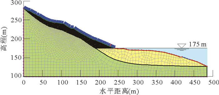
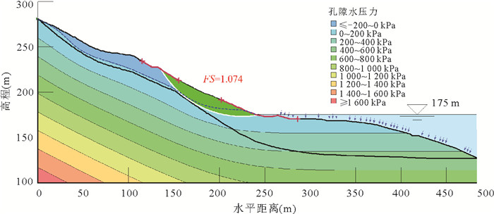
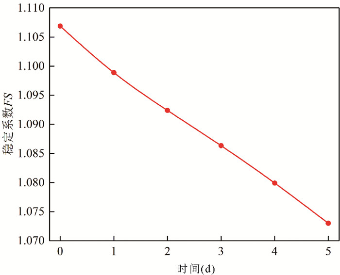
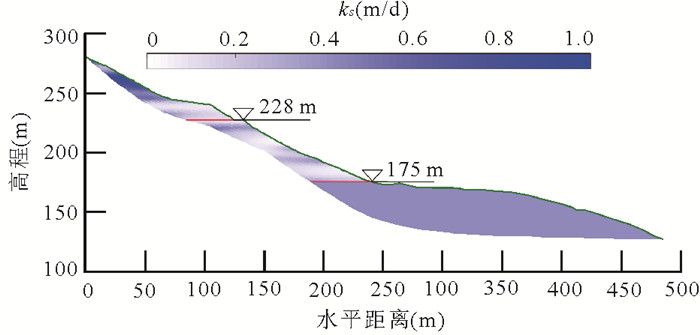
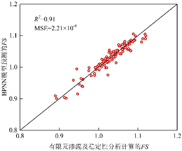
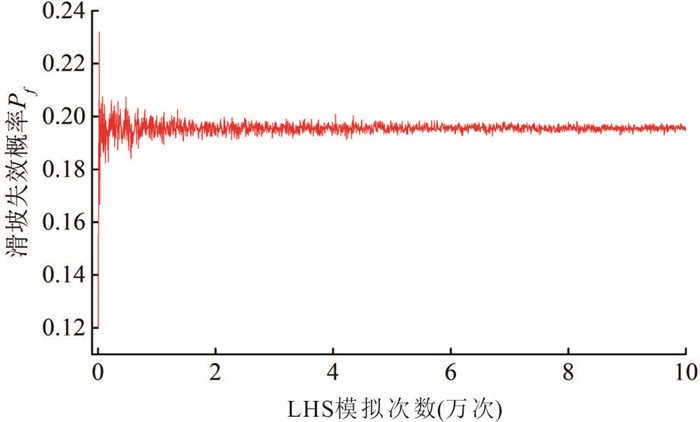
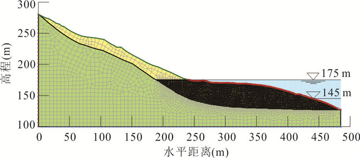
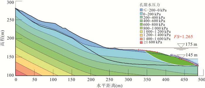
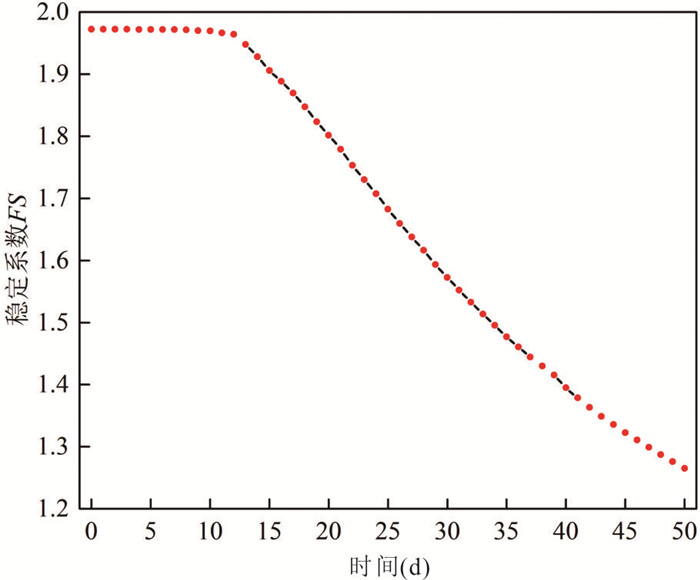
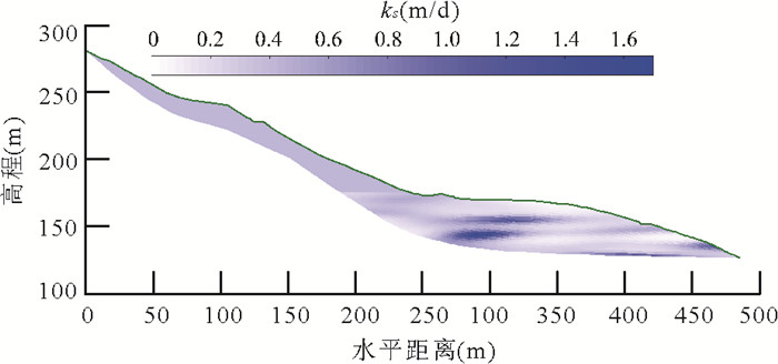
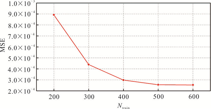
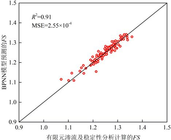
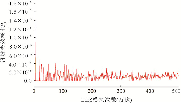
Traditional probabilitic analyses of landslides do not take into account the influence of the spatial variability of hydraulic conductivity of landslide mass. To characterize the effect of the spatial variability of the hydraulic conductivity of landslide mass, this paper proposes a back-propagation neural network-based method for slope reliability analysis involving spatially variable soil parameters. The Karhunen-Loève series expansion method is used to discretize the non-Gaussian random field of the saturated hydraulic conductivity of landslide mass. The back-propagation neural network is adopted to construct the surrogate model of the factor of safety of a spatially variable slope. The Baishuihe landslide is investigated as an example to estimate the landslide probability caused by the rainstorm and sudden drop of reservoir water level, respectively. The effectiveness of the proposed method is demonstrated through comparisons with other methods. The results indicate that the proposed method can not only effectively account for the influence of the spatial variability of the hydraulic conductivity of landslide mass on the landslide probability, but also achieve high computational efficiency for the probabilitic analysis of reservoir landslides. It can provide an effective and versatile tool for the landslide probability evaluation. In addition, when the spatial variability of soil hydraulic conductivity is considered, the Baishuihe landslide has a 19.5% probability of local failure under five consecutive days of rainstorm, while it has quite small occurrence possibility of local failure under the sudden drop of reservoir water level.
Traditional probabilitic analyses of landslides do not take into account the influence of the spatial variability of hydraulic conductivity of landslide mass. To characterize the effect of the spatial variability of the hydraulic conductivity of landslide mass, this paper proposes a back-propagation neural network-based method for slope reliability analysis involving spatially variable soil parameters. The Karhunen-Loève series expansion method is used to discretize the non-Gaussian random field of the saturated hydraulic conductivity of landslide mass. The back-propagation neural network is adopted to construct the surrogate model of the factor of safety of a spatially variable slope. The Baishuihe landslide is investigated as an example to estimate the landslide probability caused by the rainstorm and sudden drop of reservoir water level, respectively. The effectiveness of the proposed method is demonstrated through comparisons with other methods. The results indicate that the proposed method can not only effectively account for the influence of the spatial variability of the hydraulic conductivity of landslide mass on the landslide probability, but also achieve high computational efficiency for the probabilitic analysis of reservoir landslides. It can provide an effective and versatile tool for the landslide probability evaluation. In addition, when the spatial variability of soil hydraulic conductivity is considered, the Baishuihe landslide has a 19.5% probability of local failure under five consecutive days of rainstorm, while it has quite small occurrence possibility of local failure under the sudden drop of reservoir water level.
2024, 49(5): 1692-1705.
doi: 10.3799/dqkx.2023.003
Abstract:
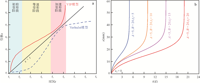
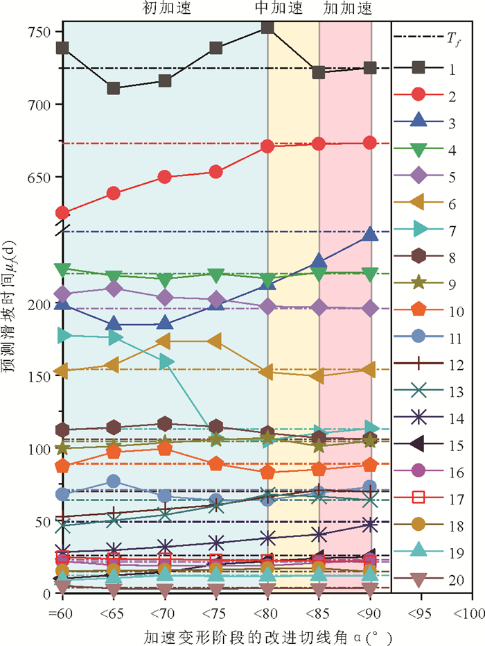
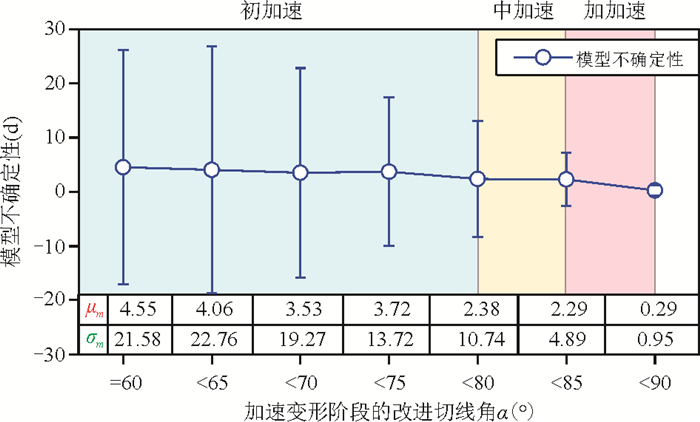
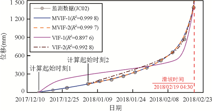
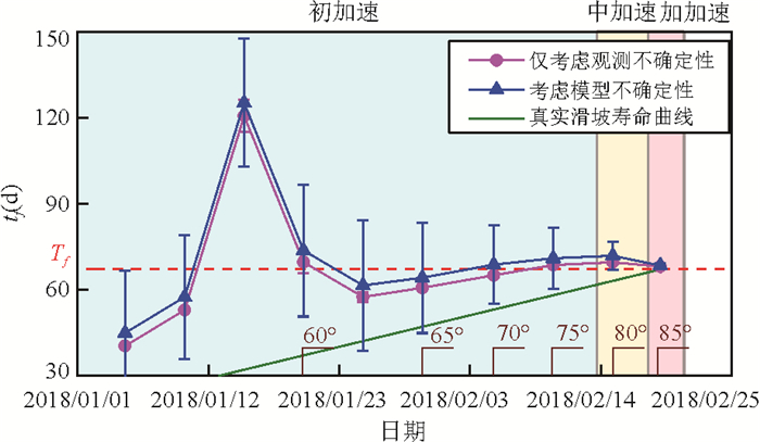
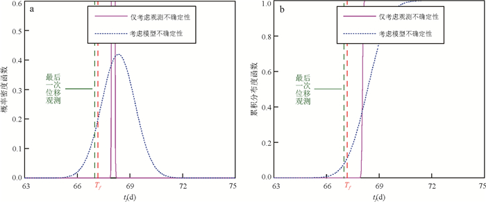
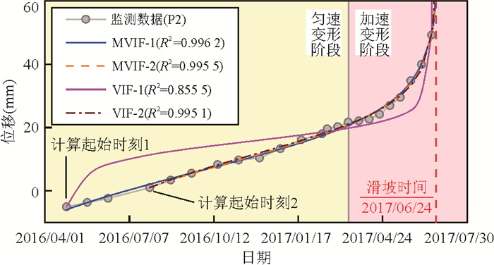
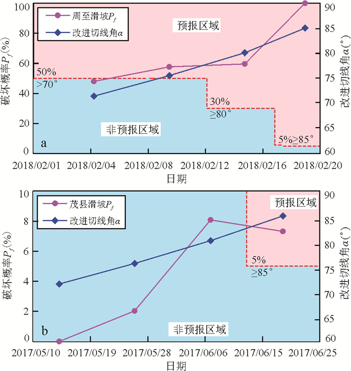
Landslide time-of-failure forecast is an essential part of landslide disaster prevention and control. However, due to the uncertainty of the landslide evolution process, it is challenging to forecast the occurrence time of landslide events accurately. The Verhulst inverse-function model is a common landslide time-of-failure forecasting model, but the model suffers from the problems of poor fitting quality and low forecasting accuracy of displacement monitoring data caused by the improper selection of the calculation starting points. To address this deficiency, an improved Verhulst inverse-function model (MVIF model) is proposed and analyzed for near real-time probabilistic forecast.The results show that (1) the MVIF model addresses the problem of harsh selection of the calculation starting points in the original model; (2) the MVIF model has high forecasting accuracy and can make reliable forecasts after the landslide enters the medium accelerating deformation phase; (3) the combination of predicted landslide time and failure probability provides a new forecasting criterion. This study can provide valuable reference for early warning and forecast of creeping landslides.
Landslide time-of-failure forecast is an essential part of landslide disaster prevention and control. However, due to the uncertainty of the landslide evolution process, it is challenging to forecast the occurrence time of landslide events accurately. The Verhulst inverse-function model is a common landslide time-of-failure forecasting model, but the model suffers from the problems of poor fitting quality and low forecasting accuracy of displacement monitoring data caused by the improper selection of the calculation starting points. To address this deficiency, an improved Verhulst inverse-function model (MVIF model) is proposed and analyzed for near real-time probabilistic forecast.The results show that (1) the MVIF model addresses the problem of harsh selection of the calculation starting points in the original model; (2) the MVIF model has high forecasting accuracy and can make reliable forecasts after the landslide enters the medium accelerating deformation phase; (3) the combination of predicted landslide time and failure probability provides a new forecasting criterion. This study can provide valuable reference for early warning and forecast of creeping landslides.


2024, 49(5): 1706-1721.
doi: 10.3799/dqkx.2022.341
Abstract:
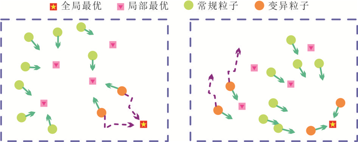
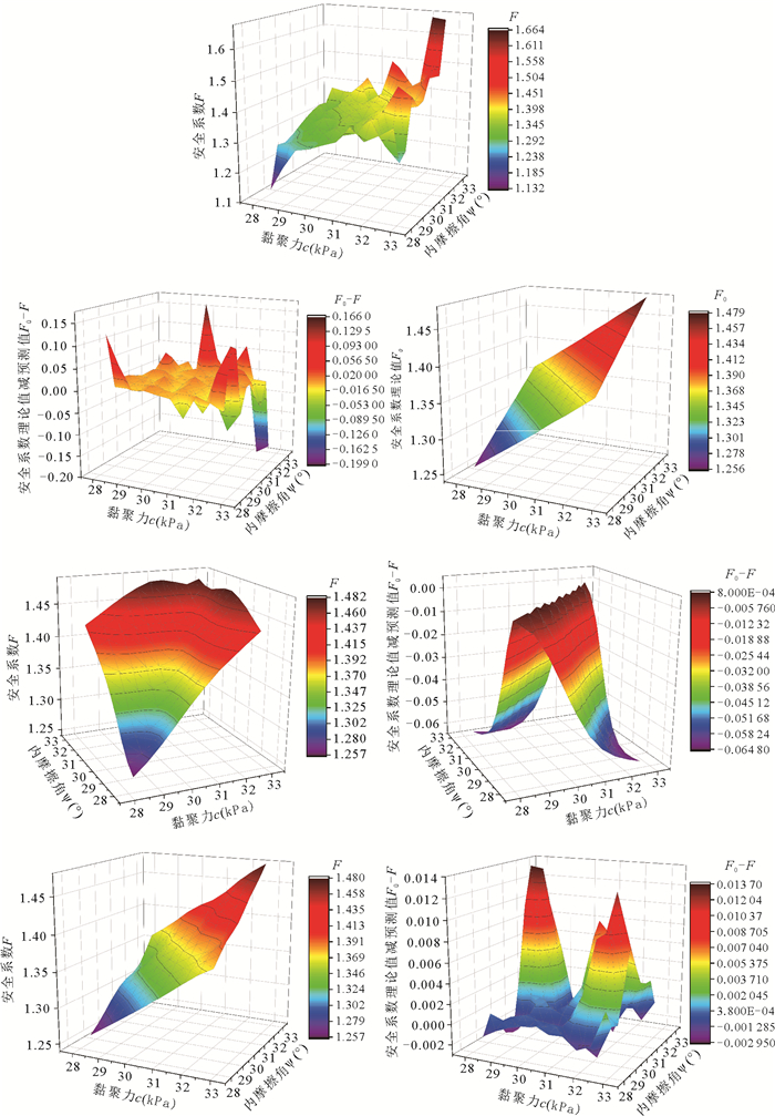
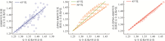
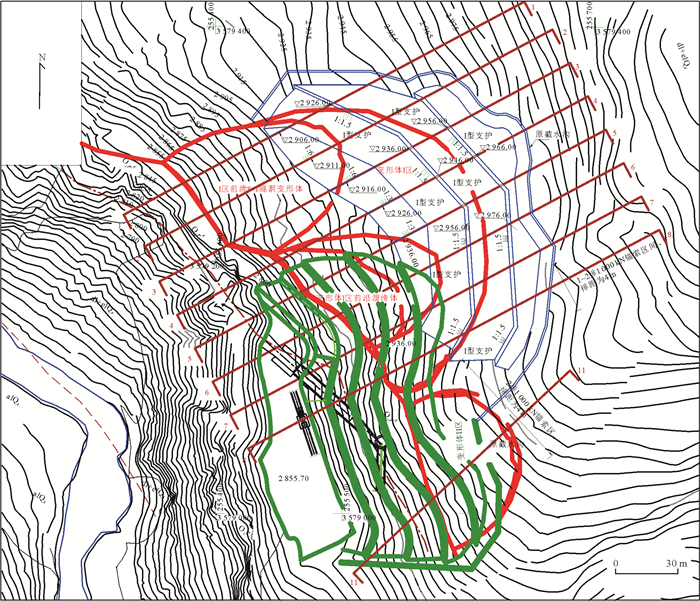
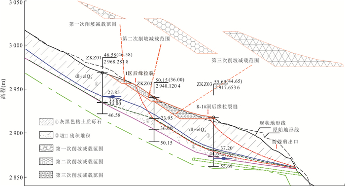
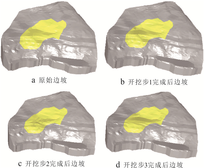
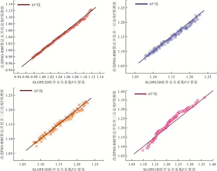
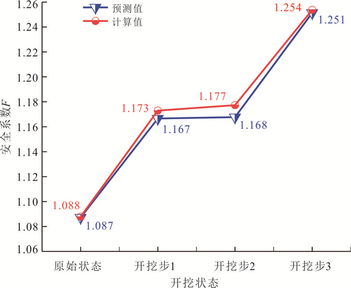
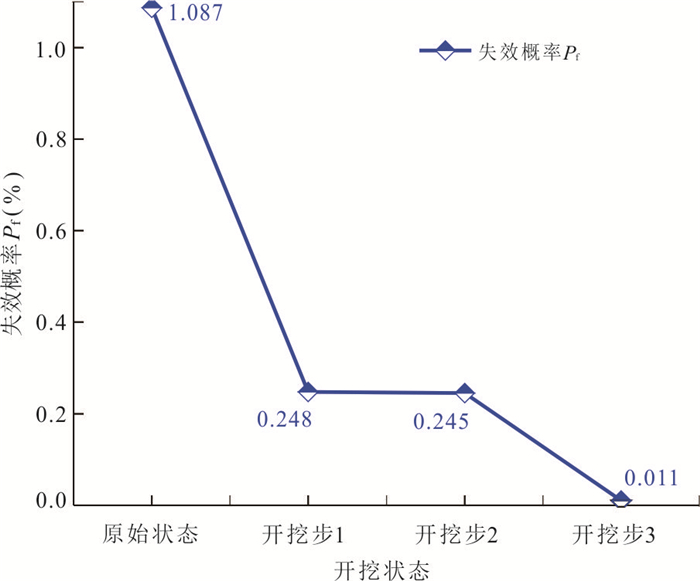
Three-dimensional slope model can truly reflect the spatial effect of slope and improve the accuracy of slope reliability calculation, however, due to the huge calculation volume of three-dimensional slope model and the lack of display expression of safety coefficient, the slope reliability analysis is mainly based on two-dimensional simplified model, and the research for three-dimensional slope reliability analysis is still insufficient. A three-dimensional slope reliability analysis method based on Spencer's method, adaptive variational particle swarm optimization algorithm and radial basis function neural network (RBF) is proposed. By introducing variational operators to the traditional PSO algorithm, the shortcomings of its low search accuracy and inefficient late iterations are improved. Based on the three-dimensional Spencer method, the calculation model of three-dimensional slope safety coefficient is constructed for reliability analysis by combining the improved PSO algorithm with RBF neural network to realize the display of three-dimensional slope function, and the improvement of the calculation accuracy and efficiency of the method compared with the traditional method is verified through the reliability analysis of the scalene vertebral ellipsoid slide; further research is conducted on the process of load-reducing excavation of the left bank slope of Kakiwa. The results show that the stability and reliability of the slope can be effectively improved after the effect of slope cutting and load reduction, and the probability of slope failure is reduced by nearly 2 orders of magnitude.
Three-dimensional slope model can truly reflect the spatial effect of slope and improve the accuracy of slope reliability calculation, however, due to the huge calculation volume of three-dimensional slope model and the lack of display expression of safety coefficient, the slope reliability analysis is mainly based on two-dimensional simplified model, and the research for three-dimensional slope reliability analysis is still insufficient. A three-dimensional slope reliability analysis method based on Spencer's method, adaptive variational particle swarm optimization algorithm and radial basis function neural network (RBF) is proposed. By introducing variational operators to the traditional PSO algorithm, the shortcomings of its low search accuracy and inefficient late iterations are improved. Based on the three-dimensional Spencer method, the calculation model of three-dimensional slope safety coefficient is constructed for reliability analysis by combining the improved PSO algorithm with RBF neural network to realize the display of three-dimensional slope function, and the improvement of the calculation accuracy and efficiency of the method compared with the traditional method is verified through the reliability analysis of the scalene vertebral ellipsoid slide; further research is conducted on the process of load-reducing excavation of the left bank slope of Kakiwa. The results show that the stability and reliability of the slope can be effectively improved after the effect of slope cutting and load reduction, and the probability of slope failure is reduced by nearly 2 orders of magnitude.


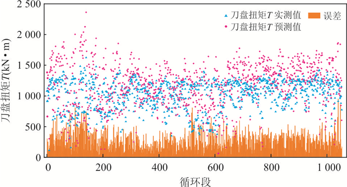
2024, 49(5): 1722-1735.
doi: 10.3799/dqkx.2022.331
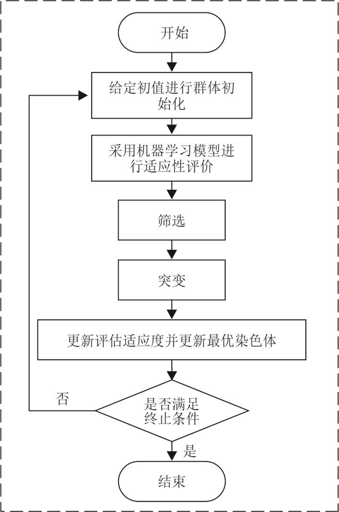
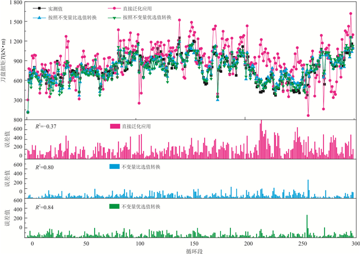
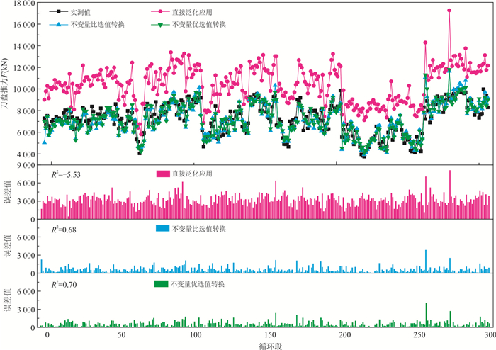
Abstract:
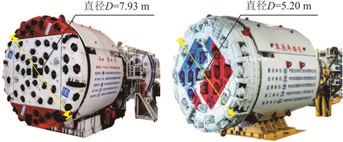
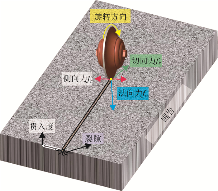
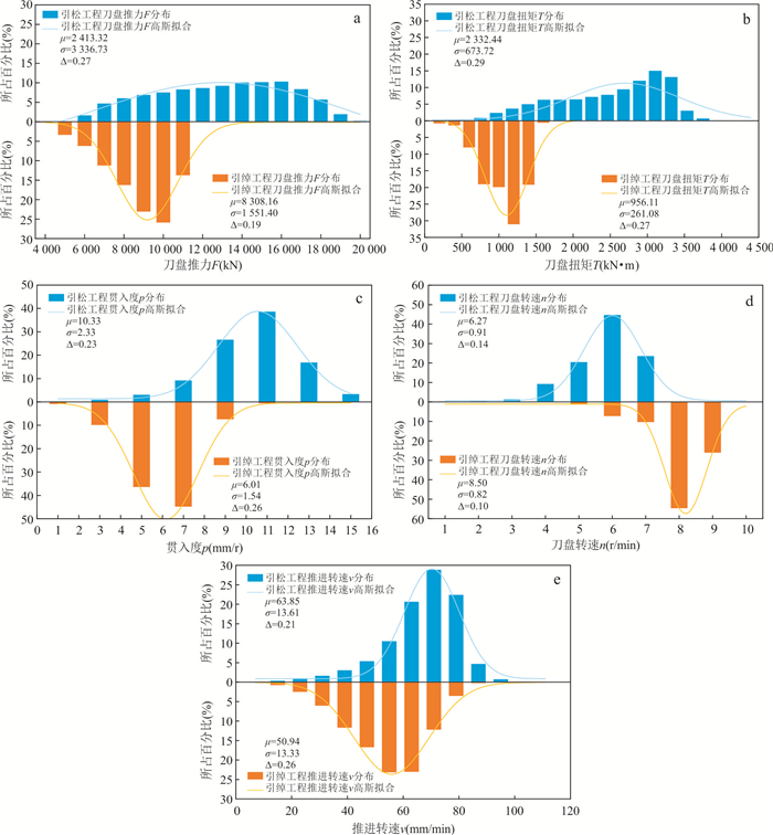
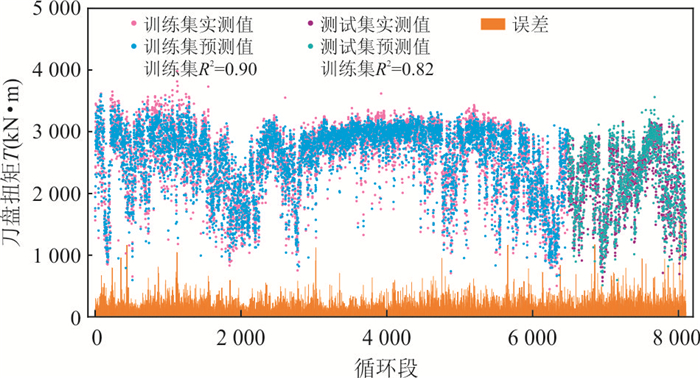
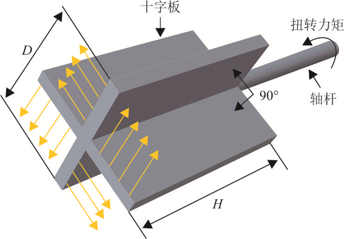
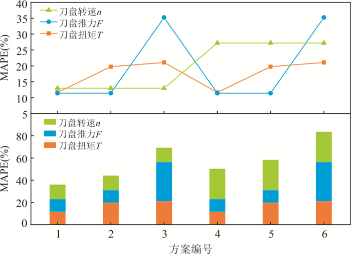
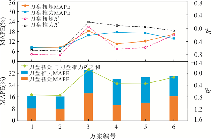
A large amount of data have been collected in TBM information construction, and the establishment of machine learning model through data mining is the premise of realizing TBM intelligence. However, at the initial stage of TBM construction, the prediction performance of machine learning model is poor due to the lack of data; At the same time, due to the differences in TBM equipment structure and cutterhead diameter, the machine learning model based on historical projects training is not suitable for new projects. In order to solve this bottleneck problem, the physical invariants only related to the number of cutters and the diameter of the cutter head are derived from the force analysis of a single cutter, the empirical method and the torsional shear experimental model. The new projects data can be converted by using the conversion scheme composed of invariants; Then, the conversion scheme of key parameters of rock breaking with the best application performance in surrounding rock classification and machine learning model is selected; Then, the genetic algorithm is used to iteratively search the optimal conversion scheme invariant which is suitable for the current project. The research results show that the data of Yinchao project (new project) are input into the machine learning model of Yinsong project (historical project) after "invariant" conversion, and the prediction performance R2 of cutterhead torque T and cutterhead thrust F reach 0.84 and 0.70 respectively. By using this conversion scheme invariant, the TBM construction data of different projects can be normalized and analyzed under the same framework, and the machine learning model trained based on historical project data is realized to guide the construction of new projects. The research results can provide reference for the cross project application of TBM machine learning model.
A large amount of data have been collected in TBM information construction, and the establishment of machine learning model through data mining is the premise of realizing TBM intelligence. However, at the initial stage of TBM construction, the prediction performance of machine learning model is poor due to the lack of data; At the same time, due to the differences in TBM equipment structure and cutterhead diameter, the machine learning model based on historical projects training is not suitable for new projects. In order to solve this bottleneck problem, the physical invariants only related to the number of cutters and the diameter of the cutter head are derived from the force analysis of a single cutter, the empirical method and the torsional shear experimental model. The new projects data can be converted by using the conversion scheme composed of invariants; Then, the conversion scheme of key parameters of rock breaking with the best application performance in surrounding rock classification and machine learning model is selected; Then, the genetic algorithm is used to iteratively search the optimal conversion scheme invariant which is suitable for the current project. The research results show that the data of Yinchao project (new project) are input into the machine learning model of Yinsong project (historical project) after "invariant" conversion, and the prediction performance R2 of cutterhead torque T and cutterhead thrust F reach 0.84 and 0.70 respectively. By using this conversion scheme invariant, the TBM construction data of different projects can be normalized and analyzed under the same framework, and the machine learning model trained based on historical project data is realized to guide the construction of new projects. The research results can provide reference for the cross project application of TBM machine learning model.

2024, 49(5): 1736-1745.
doi: 10.3799/dqkx.2023.048
Abstract:
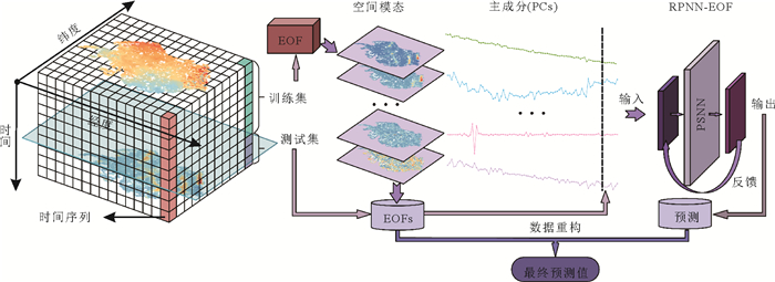
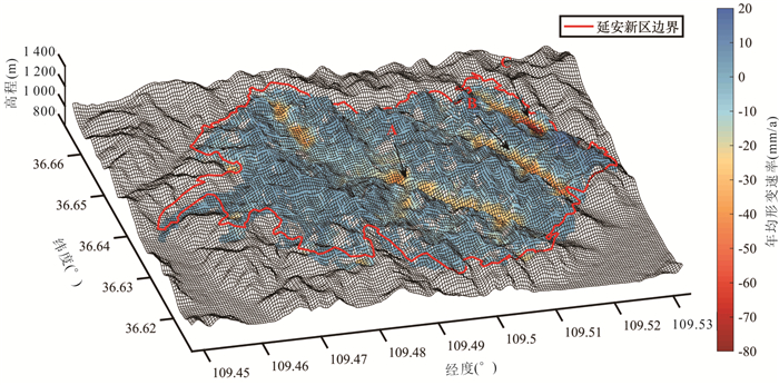
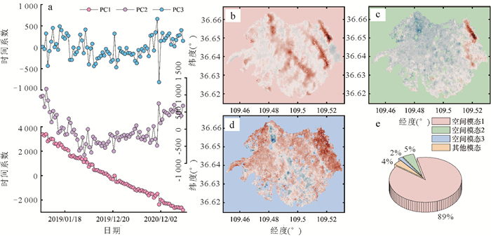
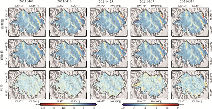
Land subsidence is the loss of land elevation formed by a combination of natural and human factors. To prevent the delayed progressive geohazards, it is essential to predict large-scale land subsidence with high efficiency. However, the current prediction methods usually neglect spatial characteristics of land subsidence, which are time-consuming due to the issue of single-point cycle. To address the problem, a new prediction method of large-scale land subsidence based on multi-temporal InSAR and machine learning is proposed. Firstly, the large-scale land subsidence time series information is obtained by the SBAS-InSAR technique. Secondly, the spatial modes and the consistent principal components (PCs) are extracted from the time series information with the empirical orthogonal function (EOF). Finally, the PCs are trained and predicted by predictive model based on the ridge polynomial neural network with error-output feedbacks (RPNN-EOF), and the outcomes are reconstructed back to the land subsidence time series. The 84-view Sentinel-1A data from August 2018 to May 2021 of Yan'an New District were adopted in the land subsidence time seriesacquisition. Simultaneously, the spatial modes extracted by EOF can clearly reveal the spatial variation characteristics of the whole new district. The prediction results show that the root mean square error and modeling time of the proposed method is reduced by at least 22.7% and 27.5% respectively, in comparison with that by the single-point cycle pattern and the prevailing time series methods. Thus it has good practicality and applicability.
Land subsidence is the loss of land elevation formed by a combination of natural and human factors. To prevent the delayed progressive geohazards, it is essential to predict large-scale land subsidence with high efficiency. However, the current prediction methods usually neglect spatial characteristics of land subsidence, which are time-consuming due to the issue of single-point cycle. To address the problem, a new prediction method of large-scale land subsidence based on multi-temporal InSAR and machine learning is proposed. Firstly, the large-scale land subsidence time series information is obtained by the SBAS-InSAR technique. Secondly, the spatial modes and the consistent principal components (PCs) are extracted from the time series information with the empirical orthogonal function (EOF). Finally, the PCs are trained and predicted by predictive model based on the ridge polynomial neural network with error-output feedbacks (RPNN-EOF), and the outcomes are reconstructed back to the land subsidence time series. The 84-view Sentinel-1A data from August 2018 to May 2021 of Yan'an New District were adopted in the land subsidence time seriesacquisition. Simultaneously, the spatial modes extracted by EOF can clearly reveal the spatial variation characteristics of the whole new district. The prediction results show that the root mean square error and modeling time of the proposed method is reduced by at least 22.7% and 27.5% respectively, in comparison with that by the single-point cycle pattern and the prevailing time series methods. Thus it has good practicality and applicability.
2024, 49(5): 1746-1758.
doi: 10.3799/dqkx.2023.043
Abstract:
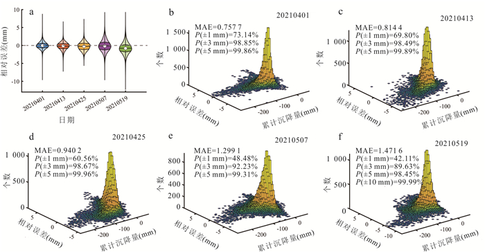
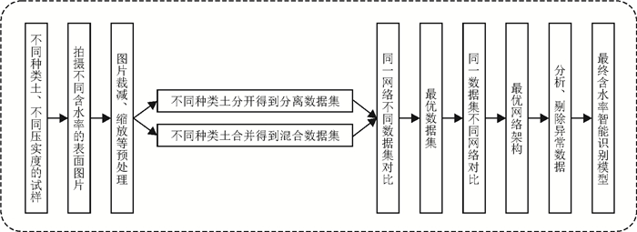
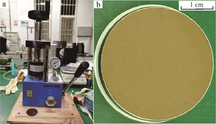
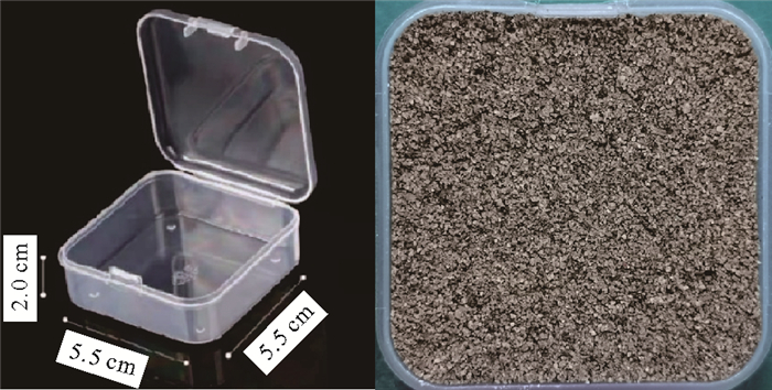
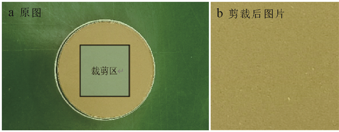
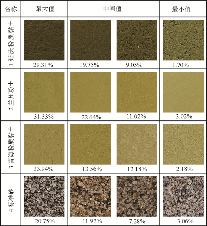
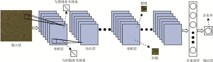
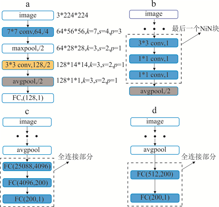
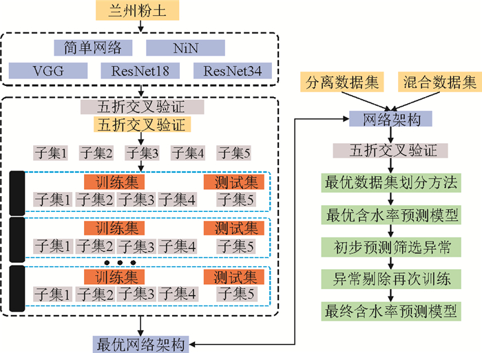
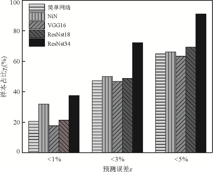
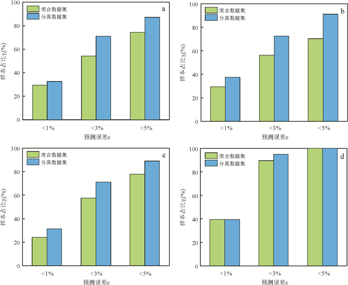
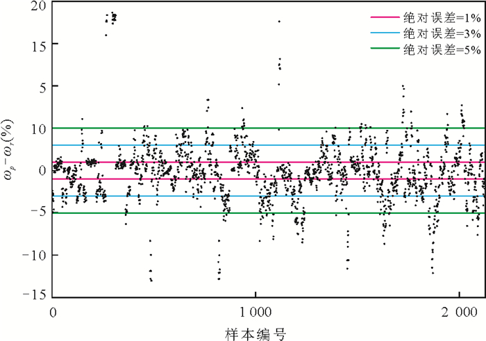
The moisture content of the soil is the main factor affecting the quality of fine-grained soil. Rapid recognition of soil surface moisture content is an urgent need for developing intelligent monitoring and construction technology in agricultural and geotechnical engineering. In order to overcome the limitation that traditional water content measurement or monitoring methods cannot meet the real-time nondestructive monitoring of soil surface moisture content, an intelligent moisture content recognition algorithm based on the image is developed. Firstly, we collected surface photos of 4 different types of soils under different moisture contents in the laboratory and obtained a high-quality sample library of more than 1 400 pictures, which laid a data foundation for machine learning model construction. Then the classical convolutional neural network is used to learn the image dataset of soil moisture content, and the intelligent recognition model of soil moisture content is established. The model comparison results show that the model based on ResNet34 architecture has the best moisture content recognition effect, and the average error of moisture content prediction on the test set is about 2%. This model basically meets the requirement of real-time nondestructive monitoring of soil surface moisture content and can provide an essential means for the development of intelligent monitoring and construction technology in agricultural and geotechnical engineering.
The moisture content of the soil is the main factor affecting the quality of fine-grained soil. Rapid recognition of soil surface moisture content is an urgent need for developing intelligent monitoring and construction technology in agricultural and geotechnical engineering. In order to overcome the limitation that traditional water content measurement or monitoring methods cannot meet the real-time nondestructive monitoring of soil surface moisture content, an intelligent moisture content recognition algorithm based on the image is developed. Firstly, we collected surface photos of 4 different types of soils under different moisture contents in the laboratory and obtained a high-quality sample library of more than 1 400 pictures, which laid a data foundation for machine learning model construction. Then the classical convolutional neural network is used to learn the image dataset of soil moisture content, and the intelligent recognition model of soil moisture content is established. The model comparison results show that the model based on ResNet34 architecture has the best moisture content recognition effect, and the average error of moisture content prediction on the test set is about 2%. This model basically meets the requirement of real-time nondestructive monitoring of soil surface moisture content and can provide an essential means for the development of intelligent monitoring and construction technology in agricultural and geotechnical engineering.

2024, 49(5): 1759-1777.
doi: 10.3799/dqkx.2021.264
Abstract:
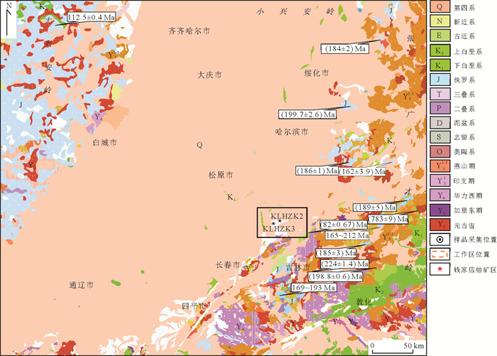
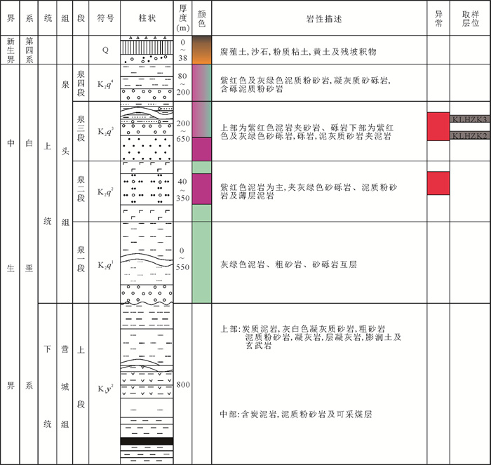
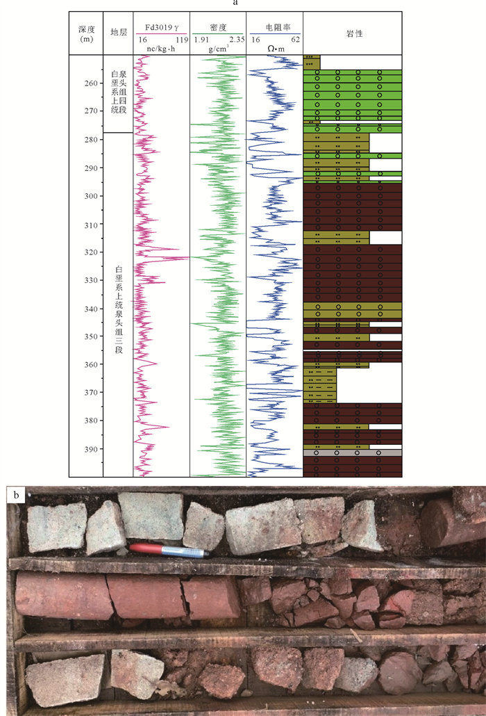
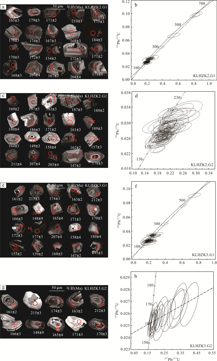
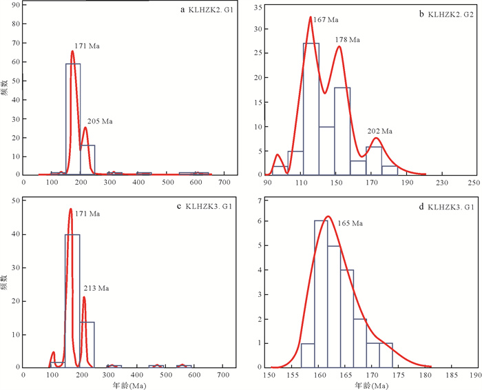
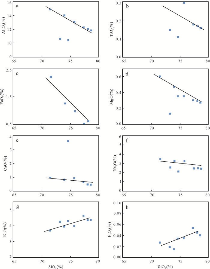
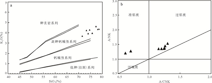
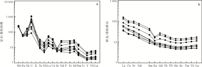
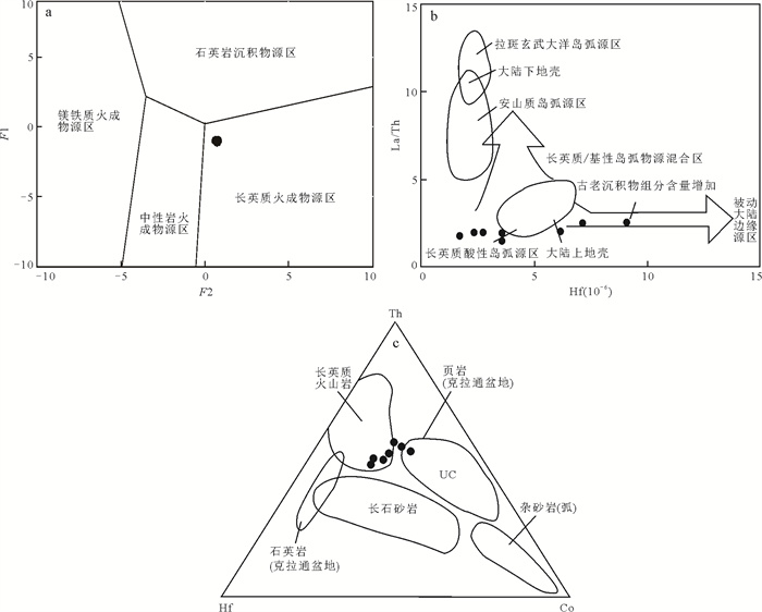
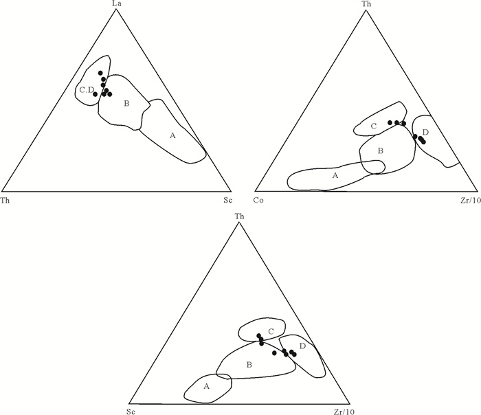
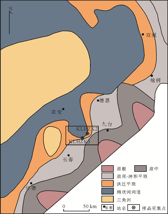
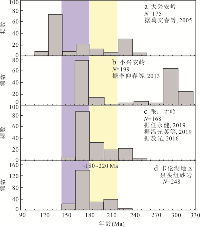
In this paper, the sandstone of Upper Cretaceous Quantou Formation in Kalun Lake area, Changchun, Jilin Province is selected to study the rock geochemistry and detrital zircon U-Pb chronology by means of X-fluorescence spectrometer, ICPMS plasma mass spectrometer and zircon La-ICP-MS U-Pb dating, so as to explore the provenance and regional sedimentary tectonic background of the study area. The results show that the main types of rocks in the source area of Quantou Formation in the study area are igneous rock assemblages with continental margin tectonic background; According to the characteristics of major elements, trace elements and rare earth elements in the study area and the U-Pb age of zircon samples, the geochemical data of samples collected in Zhangguangcailing area of Songliao basin and the study area show similarity. Both rocks are rich in large ion lithophile elements and light rare earth elements, and depleted in high field strength elements and heavy rare earth elements, showing the geochemical characteristics of volcanic arc magmatic rocks. The peak value and proportion of detrital zircon U-Pb age distribution of Quantou Formation in the study area are very similar to that of granite zircon U-Pb age distribution in zhangguangcailing area. Combined with the sand body distribution, sedimentary system and water system distribution characteristics of the eastern uplift area in the study area and the previous research results, it is comprehensively considered that the material source in the study area comes from Zhangguangcailing area. The main sedimentation of the lower section of Quantou Formation is leveling and filling, and the filled coarse clastic rock and red mudstone are not integrated on Fuxin Formation, and the upper section is dominated by overlapping sedimentation. The red sandstone and mudstone deposits of fluvial facies show gradual transition to the center of the basin. This paper makes an important contribution to reshaping the structure and provenance evolution process, mineral resource distribution and sandstone reservoir evaluation of Quantou Formation in the southeast edge of Songliao basin, and provides an important reference for the prediction of potential uranium deposits in the southeast edge of Songliao basin and the further evaluation of uranium sources in uranium mining areas.
In this paper, the sandstone of Upper Cretaceous Quantou Formation in Kalun Lake area, Changchun, Jilin Province is selected to study the rock geochemistry and detrital zircon U-Pb chronology by means of X-fluorescence spectrometer, ICPMS plasma mass spectrometer and zircon La-ICP-MS U-Pb dating, so as to explore the provenance and regional sedimentary tectonic background of the study area. The results show that the main types of rocks in the source area of Quantou Formation in the study area are igneous rock assemblages with continental margin tectonic background; According to the characteristics of major elements, trace elements and rare earth elements in the study area and the U-Pb age of zircon samples, the geochemical data of samples collected in Zhangguangcailing area of Songliao basin and the study area show similarity. Both rocks are rich in large ion lithophile elements and light rare earth elements, and depleted in high field strength elements and heavy rare earth elements, showing the geochemical characteristics of volcanic arc magmatic rocks. The peak value and proportion of detrital zircon U-Pb age distribution of Quantou Formation in the study area are very similar to that of granite zircon U-Pb age distribution in zhangguangcailing area. Combined with the sand body distribution, sedimentary system and water system distribution characteristics of the eastern uplift area in the study area and the previous research results, it is comprehensively considered that the material source in the study area comes from Zhangguangcailing area. The main sedimentation of the lower section of Quantou Formation is leveling and filling, and the filled coarse clastic rock and red mudstone are not integrated on Fuxin Formation, and the upper section is dominated by overlapping sedimentation. The red sandstone and mudstone deposits of fluvial facies show gradual transition to the center of the basin. This paper makes an important contribution to reshaping the structure and provenance evolution process, mineral resource distribution and sandstone reservoir evaluation of Quantou Formation in the southeast edge of Songliao basin, and provides an important reference for the prediction of potential uranium deposits in the southeast edge of Songliao basin and the further evaluation of uranium sources in uranium mining areas.

2024, 49(5): 1778-1792.
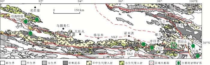
doi: 10.3799/dqkx.2022.418
Abstract:
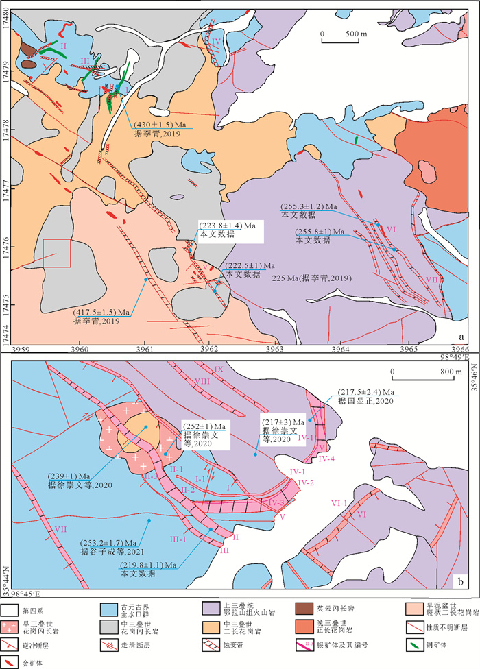
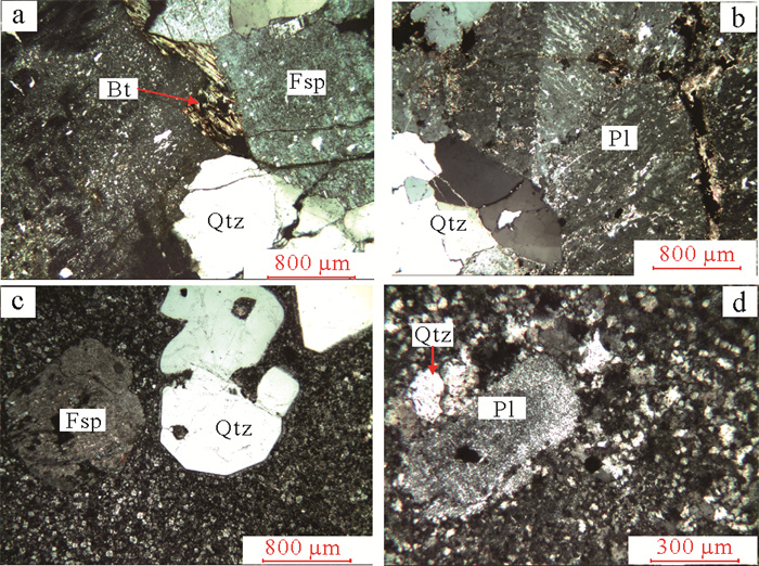
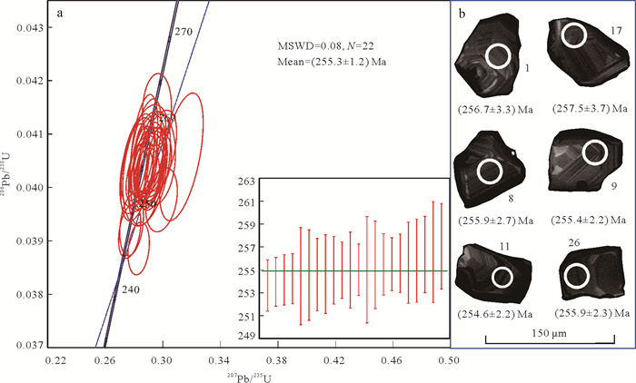
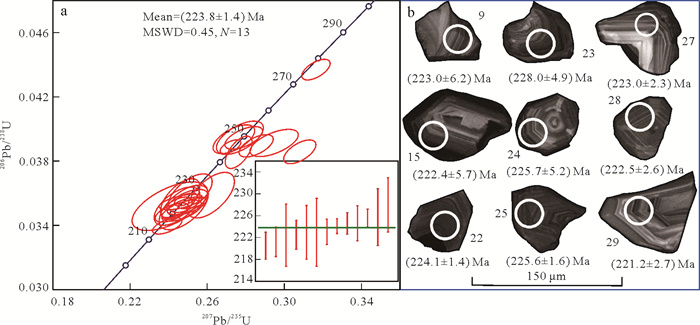
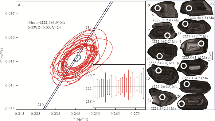
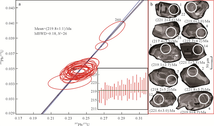
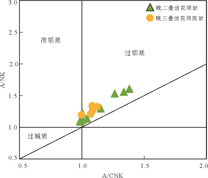
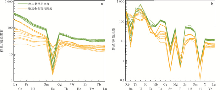
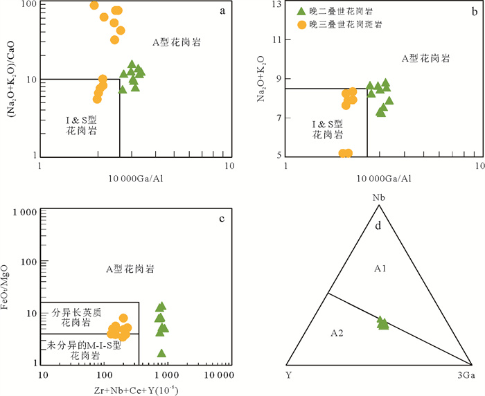
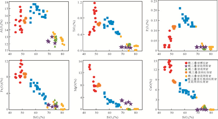
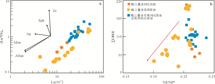
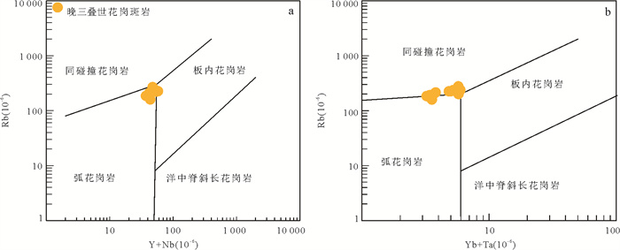
Several large silver deposits occur in the East Kunlun Orogen but their tectonic setting and related Paleo-Tethyan evolution are highly debated. Geochronological and geochemical works on the granites and porphyritic granites in the Harizha-Nagengkangqieer silver deposits of the East Kunlun Orogen were made in this study. LA-ICP-MS zircon U-Pb dating shows that the Harizha granites were emplaced at 255 Ma and the porphyritic granites in both areas between 220 Ma and 224 Ma. Late Permian Harizha granites have high SiO2 and K2O+Na2O but low CaO and MgO contents with enriched light rare earth elements, depleted heavy rare earth elements and high field strength elements, negative Eu anomalies, high Ga/Al ratios and Zr+Nb+Ce+Y values, and thus are A-type. These rocks were generated by partial melting of crustal calc-alkaline Ⅰ-type granitoids in a back-arc extensional setting because of their relatively high K2O/Na2O, Ga/Al, FeO/MgO ratios. The Late Triassic calc-alkaline, peraluminous porphyritic granites are related to silver mineralization with similar major elements but low contents of trace elements compared to the Late Permian granites, are thus the result of fractional crystallization in a post-collisional background according to this and numerous previous data.
Several large silver deposits occur in the East Kunlun Orogen but their tectonic setting and related Paleo-Tethyan evolution are highly debated. Geochronological and geochemical works on the granites and porphyritic granites in the Harizha-Nagengkangqieer silver deposits of the East Kunlun Orogen were made in this study. LA-ICP-MS zircon U-Pb dating shows that the Harizha granites were emplaced at 255 Ma and the porphyritic granites in both areas between 220 Ma and 224 Ma. Late Permian Harizha granites have high SiO2 and K2O+Na2O but low CaO and MgO contents with enriched light rare earth elements, depleted heavy rare earth elements and high field strength elements, negative Eu anomalies, high Ga/Al ratios and Zr+Nb+Ce+Y values, and thus are A-type. These rocks were generated by partial melting of crustal calc-alkaline Ⅰ-type granitoids in a back-arc extensional setting because of their relatively high K2O/Na2O, Ga/Al, FeO/MgO ratios. The Late Triassic calc-alkaline, peraluminous porphyritic granites are related to silver mineralization with similar major elements but low contents of trace elements compared to the Late Permian granites, are thus the result of fractional crystallization in a post-collisional background according to this and numerous previous data.

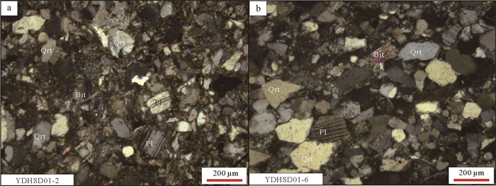
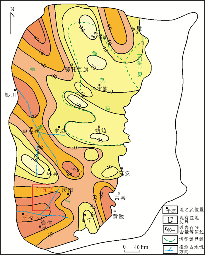
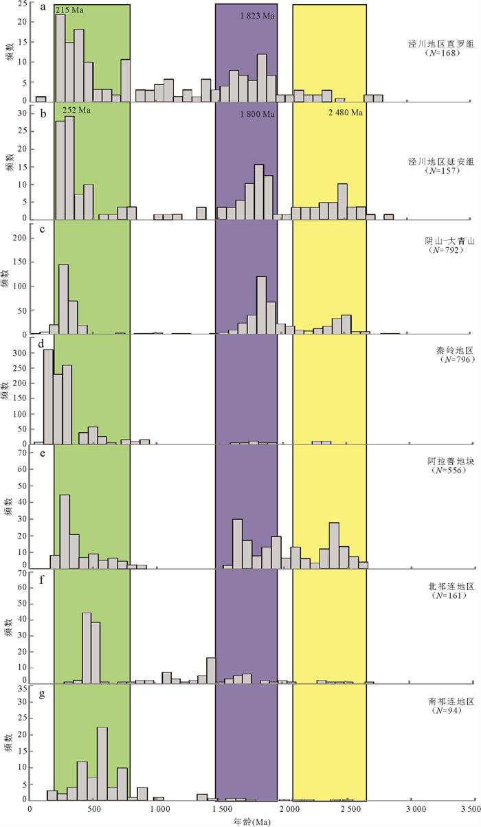
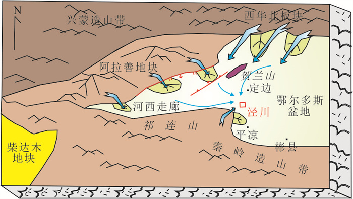
2024, 49(5): 1793-1809.
doi: 10.3799/dqkx.2023.088
Abstract:
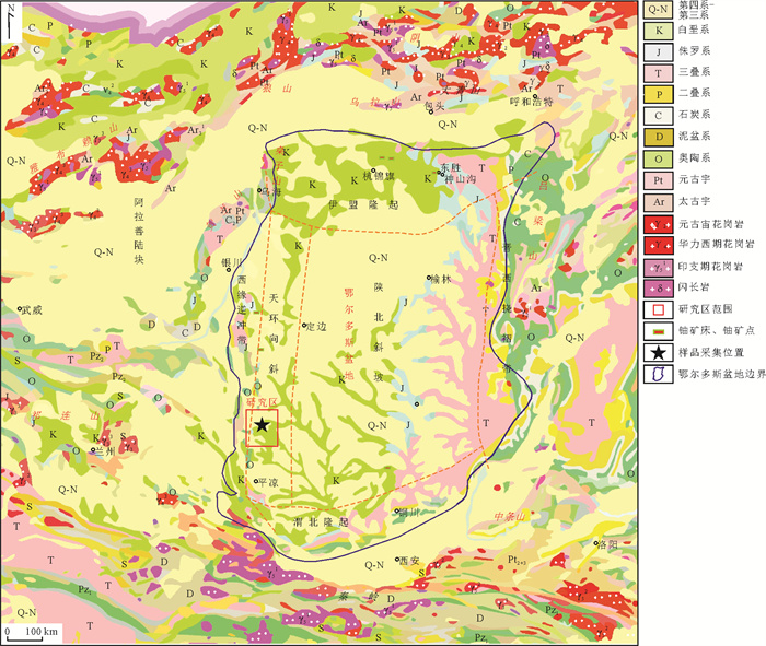
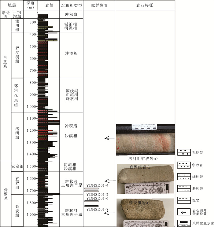
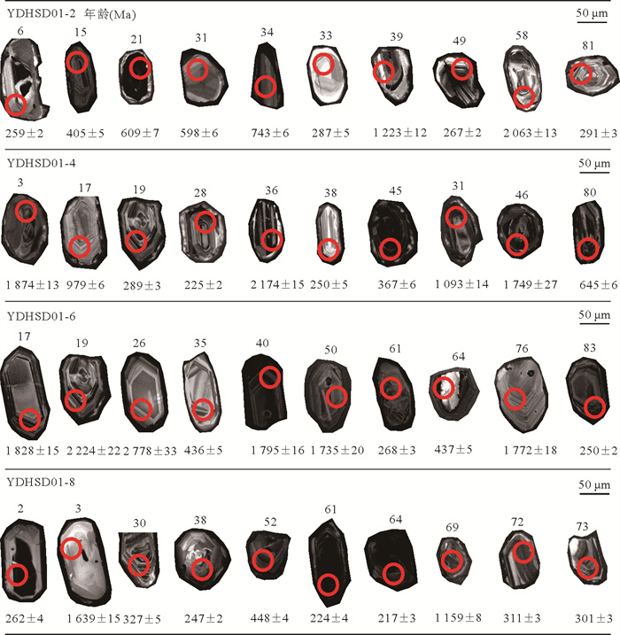
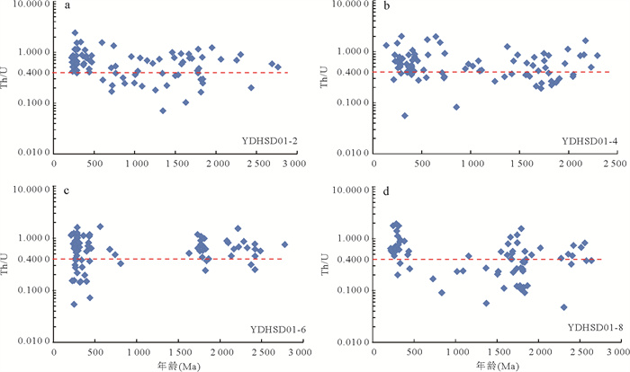
The southwest margin of the Ordos basin is located at the intersection of the Alxa massif, the Qinling orogenic belt and the Qilian orogenic belt, which is challenging to the study of the provenance and uranium mineralization of the uranium bearing rock. This paper selects the Zhiluo Formation and Yan'an Formation sandstones in the Jingchuan area to conduct clastic zircon U-Pb dating and trace element research. The analysis results show that the clastic zircon ages of the Zhiluo Formation sandstones in Jingchuan area are 215-767 Ma and 1 501-1 905 Ma; The clastic zircon ages of Yan'an Formation sandstones are 215-453 Ma, 1 506-1 918 Ma and 2 136-2 579 Ma, respectively. Compared with the isotopic chronology of the source area, it is believed that the provenance components of the Zhiluo and Yan'an Formation sandstones are relatively complex, mainly from the Alxa block, followed by the northern margin of the North China plate and the North Qilian area. During the sedimentary period from Yan'an Formation to Zhiluo Formation, Qilian Mountain and Alxa landmass were rapidly uplifted and denuded, providing provenance for Zhiluo Formation, and the proportion of provenance provided by Paleozoic and Mesozoic intrusive rocks gradually increased. The study shows that the strata of middle Jurassic can be taken as the prospecting target strata in the west margin of basin, and the ore bearing strata near the basin gradually become younger.
The southwest margin of the Ordos basin is located at the intersection of the Alxa massif, the Qinling orogenic belt and the Qilian orogenic belt, which is challenging to the study of the provenance and uranium mineralization of the uranium bearing rock. This paper selects the Zhiluo Formation and Yan'an Formation sandstones in the Jingchuan area to conduct clastic zircon U-Pb dating and trace element research. The analysis results show that the clastic zircon ages of the Zhiluo Formation sandstones in Jingchuan area are 215-767 Ma and 1 501-1 905 Ma; The clastic zircon ages of Yan'an Formation sandstones are 215-453 Ma, 1 506-1 918 Ma and 2 136-2 579 Ma, respectively. Compared with the isotopic chronology of the source area, it is believed that the provenance components of the Zhiluo and Yan'an Formation sandstones are relatively complex, mainly from the Alxa block, followed by the northern margin of the North China plate and the North Qilian area. During the sedimentary period from Yan'an Formation to Zhiluo Formation, Qilian Mountain and Alxa landmass were rapidly uplifted and denuded, providing provenance for Zhiluo Formation, and the proportion of provenance provided by Paleozoic and Mesozoic intrusive rocks gradually increased. The study shows that the strata of middle Jurassic can be taken as the prospecting target strata in the west margin of basin, and the ore bearing strata near the basin gradually become younger.
2024, 49(5): 1810-1820.
doi: 10.3799/dqkx.2022.082
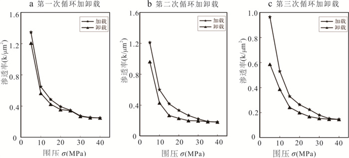
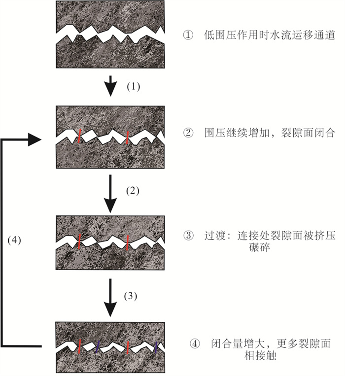
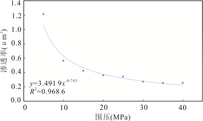
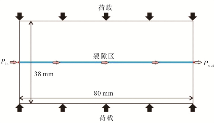
Abstract:
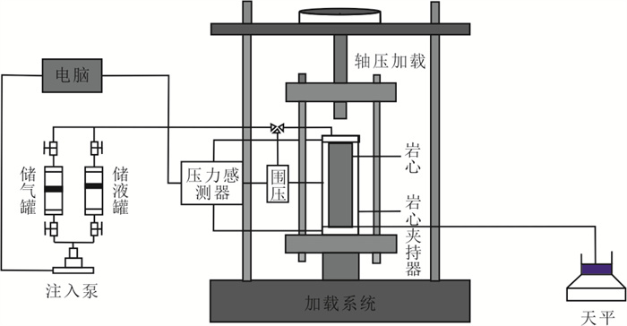
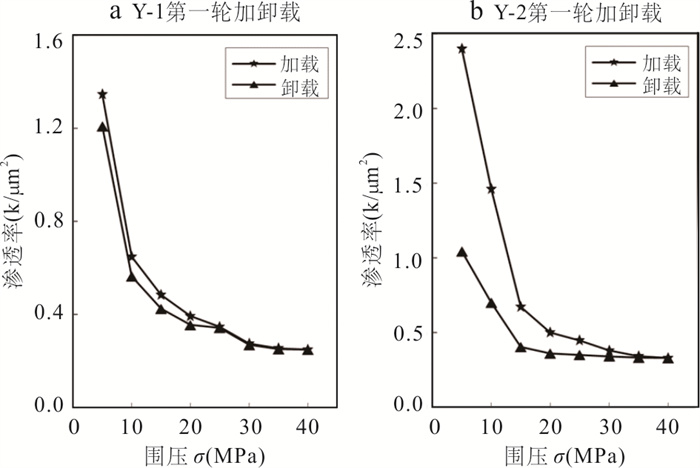
Selecting Indosinian granite in thermal storage layer of hot dry rock targets in the Gonghe basin, Qinghai Province, as the goal layer, using high pressure fluid displacement experiment device, the core fissure seepage and stress coupling loops and unloading test was carried out in this study. The influence law of stress loading process on granite rough fracture permeability was analyzed, and the evolution characteristics of granite fracture permeability in the experimental process were analyzed by numerical simulation technology. The results show that: (1) stress loading leads to deformation of fracture contact surface, which is the main factor affecting fracture seepage, and fracture permeability is negatively correlated with confining pressure. (2) The sensitivity of fracture permeability to different stress loading modes is different; (3) The mathematical empirical formula is obtained on the basis of the test, and the seepage evolution law in the granite fracture channel is analyzed by numerical simulation. The simulation results fit well with the experiment.
Selecting Indosinian granite in thermal storage layer of hot dry rock targets in the Gonghe basin, Qinghai Province, as the goal layer, using high pressure fluid displacement experiment device, the core fissure seepage and stress coupling loops and unloading test was carried out in this study. The influence law of stress loading process on granite rough fracture permeability was analyzed, and the evolution characteristics of granite fracture permeability in the experimental process were analyzed by numerical simulation technology. The results show that: (1) stress loading leads to deformation of fracture contact surface, which is the main factor affecting fracture seepage, and fracture permeability is negatively correlated with confining pressure. (2) The sensitivity of fracture permeability to different stress loading modes is different; (3) The mathematical empirical formula is obtained on the basis of the test, and the seepage evolution law in the granite fracture channel is analyzed by numerical simulation. The simulation results fit well with the experiment.

2024, 49(5): 1821-1831.
doi: 10.3799/dqkx.2022.210
Abstract:
Many deep wells in the southwestern part of the Bozhong sag reveal thick glutenite of Kongdian Formation. Due to the large burial depth, the glutenite reservoir is obviously densified, and the production of some wells is less than 10 m3/d. A part of wells have high productivity, and the differential evolution mechanism of reservoirs is a key issue that restricts exploration. Aiming at the differential evolution mechanism of the reservoir, this study carried out experiments such as thin section, scanning electron microscope, compaction simulation. It is found that the degree of development of micro-fractures determines the physical properties of reservoirs. And the differential evolution of the reservoir is significantly affected by the composition of gravel and the content of matrix. The glutenite whose parent rock comes from granite, with low matrix content, develops potash feldspar fractures, strong dissolution, and good reservoir properties. The glutenite with high matrix is characterized by underdeveloped fractures, weak dissolution, and low productivity. The glutenite mixed with a large amount of carbonate gravel has strong cementation in the early stage, and the productivity is still poor even after fracturing. The physical compaction simulation shows that intragranular fractures appear in the gravel below simulation burial depth 2 500 meters, which increase with the increase of simulation burial depth; the types and characteristics of fractures can be compared with the characteristics of micro-fractures in the study area. This confirms that glutenite with low matrix content can generate a large number of compaction fractures. Potassium feldspar and plagioclase are quite different in their ability to form fractures: potash feldspar is more prone to form fractures, and which is further corroded by later fluids, forming dissolution enlarged fractures. Plagioclase is prone to kaolinization, sodium zoisite and other secondary transformations, which changes the mechanical properties of minerals, and is not prone to form fractures.
Many deep wells in the southwestern part of the Bozhong sag reveal thick glutenite of Kongdian Formation. Due to the large burial depth, the glutenite reservoir is obviously densified, and the production of some wells is less than 10 m3/d. A part of wells have high productivity, and the differential evolution mechanism of reservoirs is a key issue that restricts exploration. Aiming at the differential evolution mechanism of the reservoir, this study carried out experiments such as thin section, scanning electron microscope, compaction simulation. It is found that the degree of development of micro-fractures determines the physical properties of reservoirs. And the differential evolution of the reservoir is significantly affected by the composition of gravel and the content of matrix. The glutenite whose parent rock comes from granite, with low matrix content, develops potash feldspar fractures, strong dissolution, and good reservoir properties. The glutenite with high matrix is characterized by underdeveloped fractures, weak dissolution, and low productivity. The glutenite mixed with a large amount of carbonate gravel has strong cementation in the early stage, and the productivity is still poor even after fracturing. The physical compaction simulation shows that intragranular fractures appear in the gravel below simulation burial depth 2 500 meters, which increase with the increase of simulation burial depth; the types and characteristics of fractures can be compared with the characteristics of micro-fractures in the study area. This confirms that glutenite with low matrix content can generate a large number of compaction fractures. Potassium feldspar and plagioclase are quite different in their ability to form fractures: potash feldspar is more prone to form fractures, and which is further corroded by later fluids, forming dissolution enlarged fractures. Plagioclase is prone to kaolinization, sodium zoisite and other secondary transformations, which changes the mechanical properties of minerals, and is not prone to form fractures.
2024, 49(5): 1832-1843.
doi: 10.3799/dqkx.2021.254
Abstract:
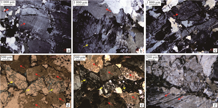
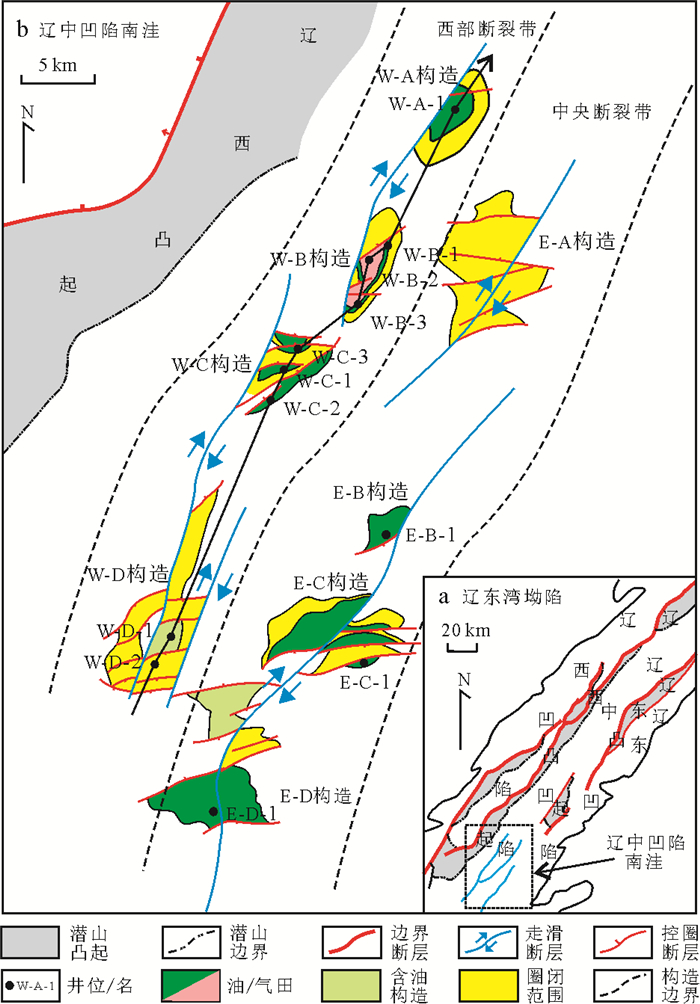
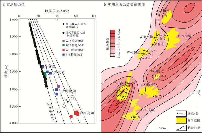
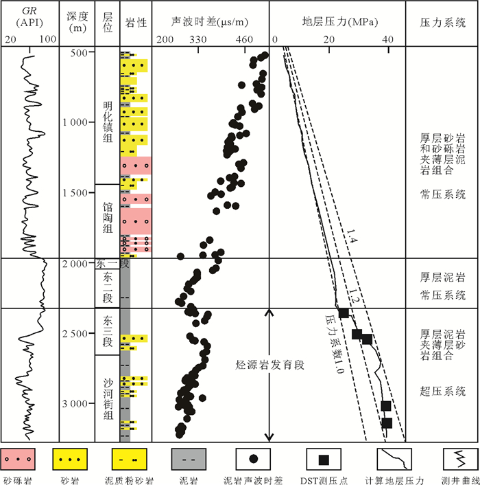
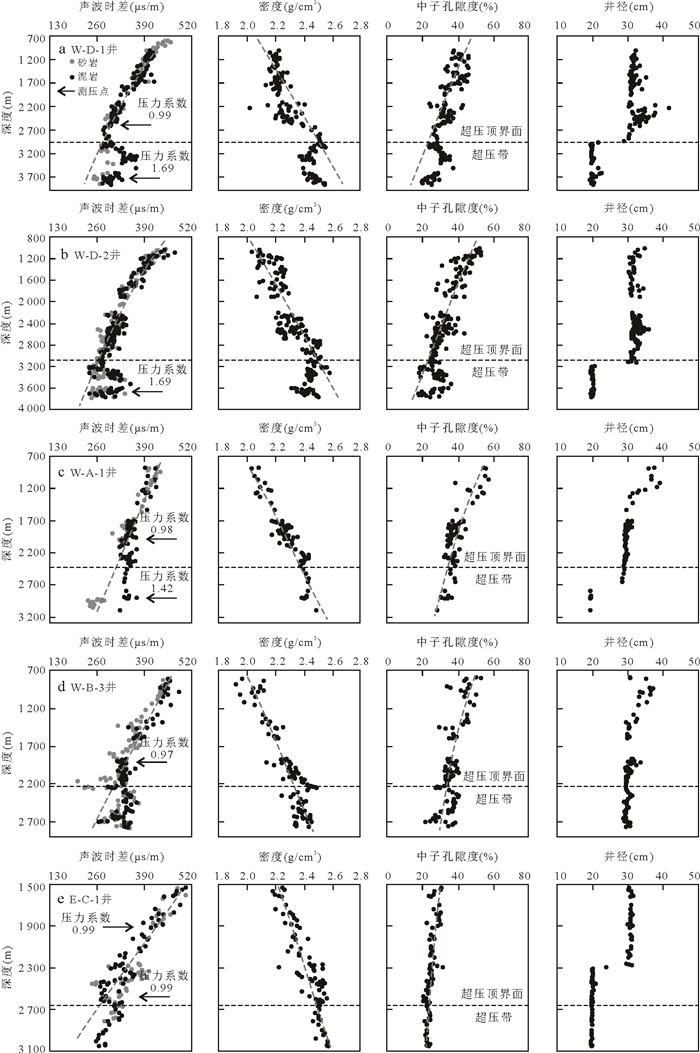
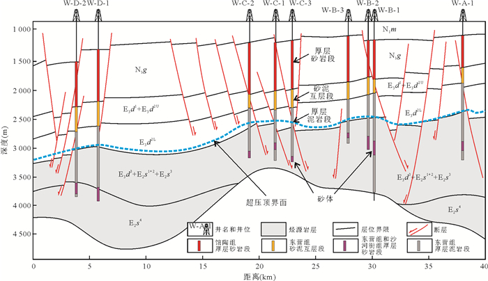
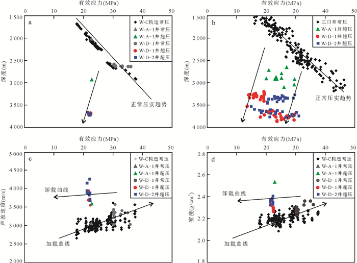
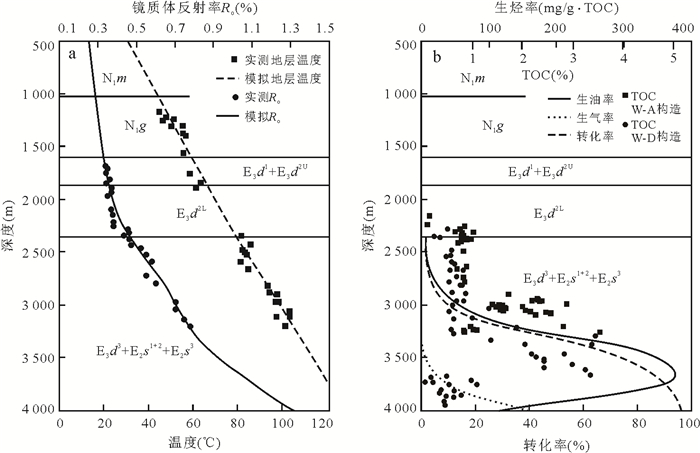
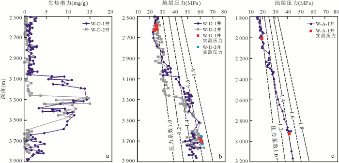
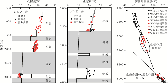
This paper deals with the origin of overpressure in the Paleogene strata, in south of Liaozhong depression, Bohai Bay Basin, through comprehensive application and analysis of various geological data and research methods, we suggest that hydrocarbon generation is the main mechanism. In some areas (W-D structure), there is overpressure formed by superposition of disequilibrium and hydrocarbon generation. The main evidences are as follows: (1) Except for W-D structure, logging curves generally do not have typical characteristics of high porosity and low density caused by disequilibrium; (2) The top depth of overpressure formed by disequilibrium in sedimentary background is inconsistent with the reality; (3) The overpressure top develops in the internal large mudstone section, with greatly varying depth range (from 2 200-3 100 m), and it is basically the same as hydrocarbon generation top of source rocks; (4) The relationship between formation effective stress with velocity and density shows that the overpressure points all fall on the "unloading" curve, and the overpressure characteristics are hydrocarbon generation; (5) The overpressure source rocks are still in large hydrocarbon generation stage, continue to provide guarantee for overpressure formation; (6) Overpressure formed by superimposition of disequilibrium and hydrocarbon generation is characterized by typical formation high porosity and low density, the relationship curves between effective stress and formation velocity and density formations show obvious unloading phenomena.
This paper deals with the origin of overpressure in the Paleogene strata, in south of Liaozhong depression, Bohai Bay Basin, through comprehensive application and analysis of various geological data and research methods, we suggest that hydrocarbon generation is the main mechanism. In some areas (W-D structure), there is overpressure formed by superposition of disequilibrium and hydrocarbon generation. The main evidences are as follows: (1) Except for W-D structure, logging curves generally do not have typical characteristics of high porosity and low density caused by disequilibrium; (2) The top depth of overpressure formed by disequilibrium in sedimentary background is inconsistent with the reality; (3) The overpressure top develops in the internal large mudstone section, with greatly varying depth range (from 2 200-3 100 m), and it is basically the same as hydrocarbon generation top of source rocks; (4) The relationship between formation effective stress with velocity and density shows that the overpressure points all fall on the "unloading" curve, and the overpressure characteristics are hydrocarbon generation; (5) The overpressure source rocks are still in large hydrocarbon generation stage, continue to provide guarantee for overpressure formation; (6) Overpressure formed by superimposition of disequilibrium and hydrocarbon generation is characterized by typical formation high porosity and low density, the relationship curves between effective stress and formation velocity and density formations show obvious unloading phenomena.

2024, 49(5): 1844-1864.
doi: 10.3799/dqkx.2022.125
Abstract:
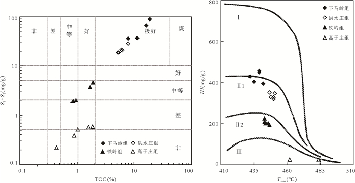
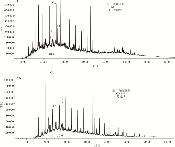
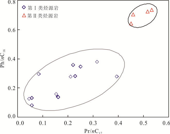
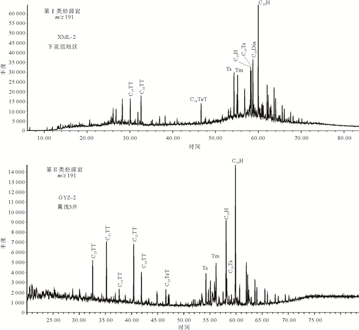
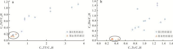
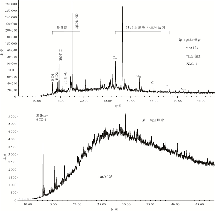
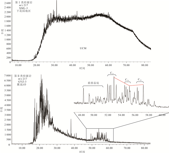
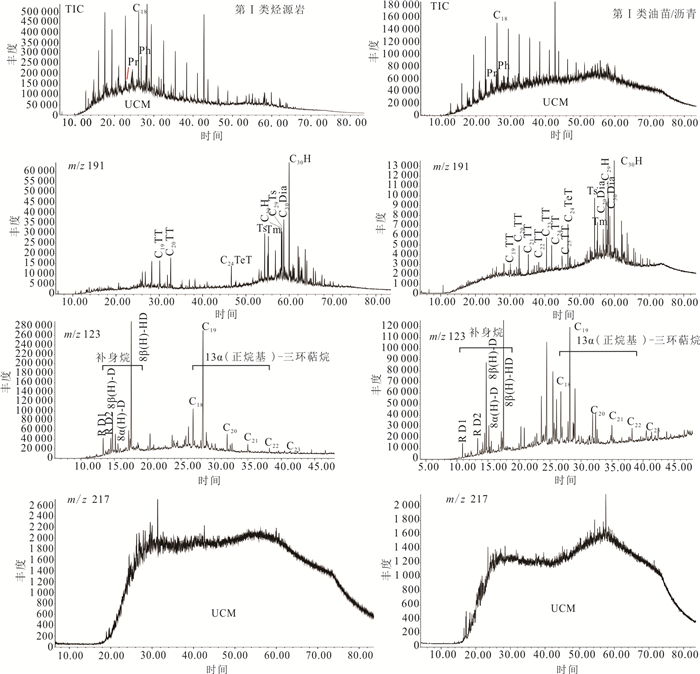
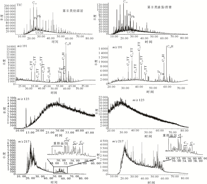
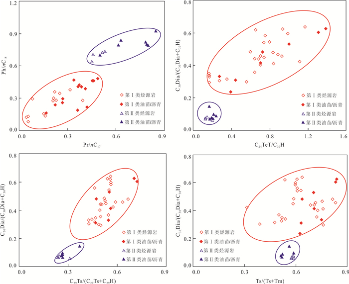
The enrichmentof Meso-Neoproterozoic oil and gas in Yanshan area has been the hot topic focused on by scholars. Total Organic Carbon (TOC) test, pyrolysis, gas chromatography (GC), gas chromatography-mass spectrometry (GC-MS) and other methods are applied in this paper to discuss organic geochemical characteristics of samples. Especially, the biomarker compounds, organic matter sources and sedimentary environment are discussed in detail. The geochemical and biomarker characteristics of oil seepage/asphalt and source rocks are compared to identify the major source rocks of Meso-Neoproterozoic strata in Yanshan Region. The results show that the source rocks of the Xiamaling and Hongshuizhuang formations, featured with high content of organic carbons, great hydrocarbon generation potential and moderate degree of thermal evolution, are good and supreme source rocks.The source rocks of Tieling Formation are poor-medium source rocks, and the degree of thermal evolution of Gaoyuzhuang Formation is excessively high to determine the type of source rocks. According to the characteristics of biomarkers in the researched area, the source rocks are divided into two categories. Wherein, the source rocks of Hongshuizhuang, Tieling and Xiamaling Formations are classified into Category Ⅰ. The relative contents of acyclic isoprene pristane (Pr) and phytane (Ph) are very low, with certain abundance of regular C20 tricyclic terpane (C20TT), C19TT and special 13α (n-alkyl) - tricyclic terpanes, rich in tetracyclic terpane (C24TeT), norneohopane (Ts and C29Ts) and rearranged hopanes (C30Dia), and are characterized by the absence of sterane compound.Revealing moderate degree of thermal evolution, anoxic sedimentary environment and a special hydrocarbon generating organism of Category Ⅰ source rocks. Gaoyuzhuang Formation, provided with Category Ⅱsource rocks, is characterized with high abundance of C23-C25TT and regular hopane, common C27-C29 regular steranes, low abundance of C24 tetracyclic terpane, norneohopane and rearranged hopane, and no drimane and 13α (n-alkyl)-featured with tricyclic terpene serial compound is detected, showing the characteristics of crude oil in typical marine carbonate sedimentary environment and indicating various biological sources. The oil and source rock correlation shows that Category Ⅰ oil seepage/asphalt mainly originates from the source rocks of Hongshuizhuang Formation, while the organic geochemical composition characteristics of CategoryⅡasphalt sandstone are extremely similar to the source rocks of Gaoyuzhuang Formation.
The enrichmentof Meso-Neoproterozoic oil and gas in Yanshan area has been the hot topic focused on by scholars. Total Organic Carbon (TOC) test, pyrolysis, gas chromatography (GC), gas chromatography-mass spectrometry (GC-MS) and other methods are applied in this paper to discuss organic geochemical characteristics of samples. Especially, the biomarker compounds, organic matter sources and sedimentary environment are discussed in detail. The geochemical and biomarker characteristics of oil seepage/asphalt and source rocks are compared to identify the major source rocks of Meso-Neoproterozoic strata in Yanshan Region. The results show that the source rocks of the Xiamaling and Hongshuizhuang formations, featured with high content of organic carbons, great hydrocarbon generation potential and moderate degree of thermal evolution, are good and supreme source rocks.The source rocks of Tieling Formation are poor-medium source rocks, and the degree of thermal evolution of Gaoyuzhuang Formation is excessively high to determine the type of source rocks. According to the characteristics of biomarkers in the researched area, the source rocks are divided into two categories. Wherein, the source rocks of Hongshuizhuang, Tieling and Xiamaling Formations are classified into Category Ⅰ. The relative contents of acyclic isoprene pristane (Pr) and phytane (Ph) are very low, with certain abundance of regular C20 tricyclic terpane (C20TT), C19TT and special 13α (n-alkyl) - tricyclic terpanes, rich in tetracyclic terpane (C24TeT), norneohopane (Ts and C29Ts) and rearranged hopanes (C30Dia), and are characterized by the absence of sterane compound.Revealing moderate degree of thermal evolution, anoxic sedimentary environment and a special hydrocarbon generating organism of Category Ⅰ source rocks. Gaoyuzhuang Formation, provided with Category Ⅱsource rocks, is characterized with high abundance of C23-C25TT and regular hopane, common C27-C29 regular steranes, low abundance of C24 tetracyclic terpane, norneohopane and rearranged hopane, and no drimane and 13α (n-alkyl)-featured with tricyclic terpene serial compound is detected, showing the characteristics of crude oil in typical marine carbonate sedimentary environment and indicating various biological sources. The oil and source rock correlation shows that Category Ⅰ oil seepage/asphalt mainly originates from the source rocks of Hongshuizhuang Formation, while the organic geochemical composition characteristics of CategoryⅡasphalt sandstone are extremely similar to the source rocks of Gaoyuzhuang Formation.
2024, 49(5): 1865-1875.
doi: 10.3799/dqkx.2022.133
Abstract:
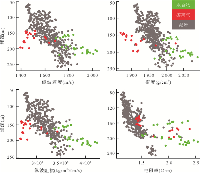
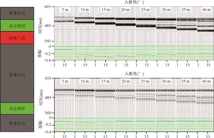
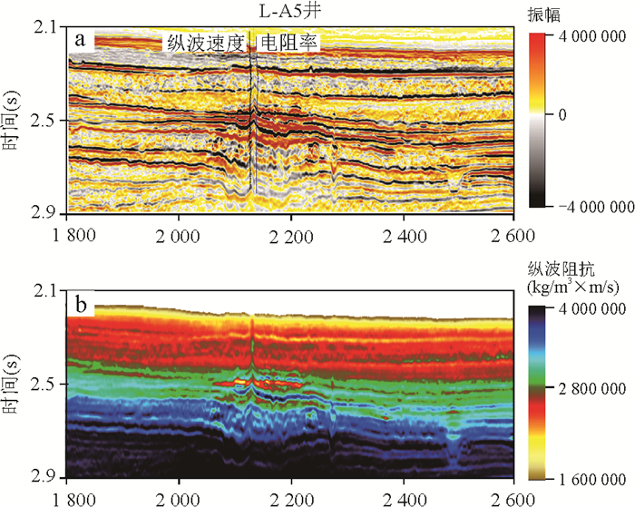
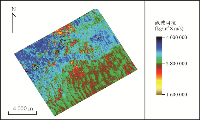
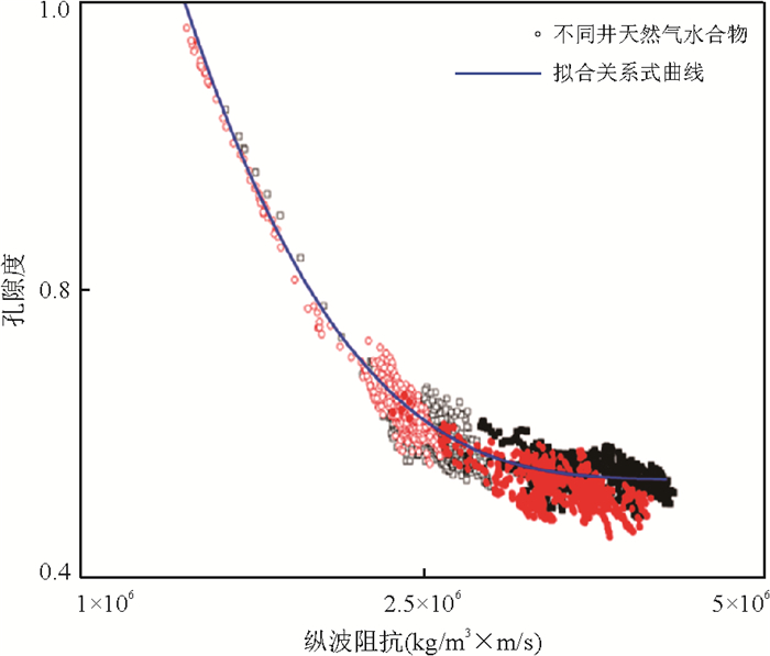
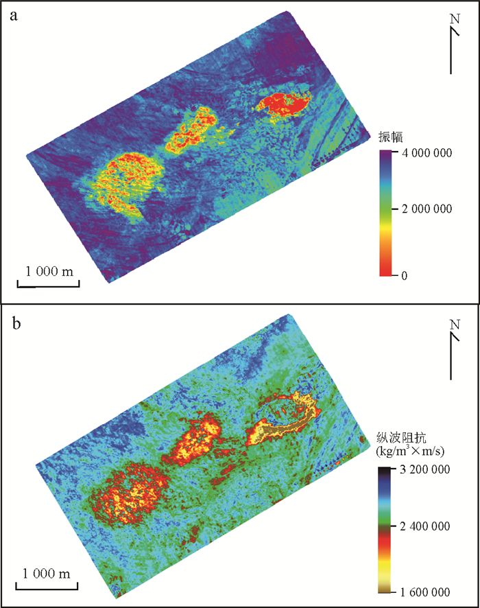
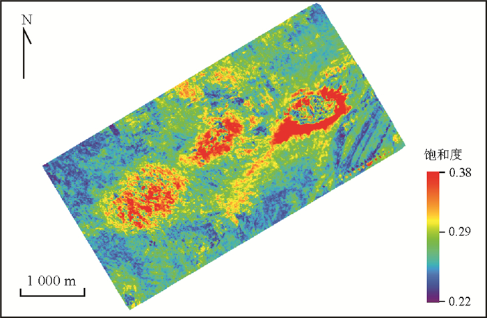
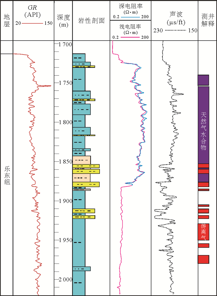
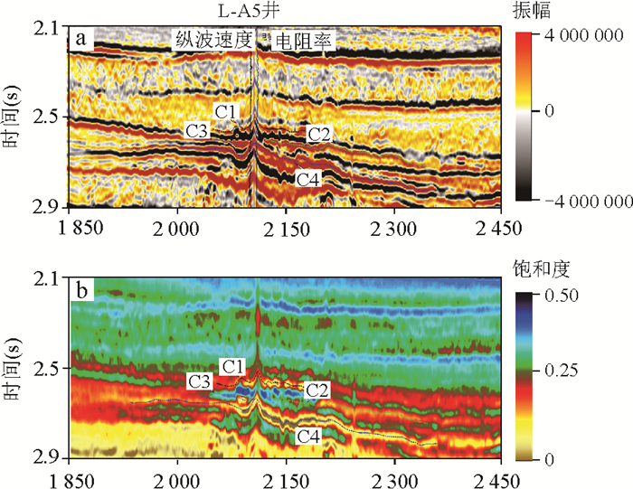
Qiongdongnan basin is a newly discovered gas hydrate exploration target area in China. There are two types of gas hydrate (i.e. pore hydrate and chimney hydrate), which are characterized by different seismic reflection characteristics. However, there are limitations in using bottom simulating reflections (BSR) in seismic profiles to identify gas hydrate in deep water area of Qiongdongnan basin. For the identification and saturation prediction of gas hydrate in Qiongdongnan basin, AVO forward modeling and broadband seismic inversion analysis are carried out in this study. The elastic parameter characteristics of natural gas hydrate were clarified, and geophysical identification methods for gas hydrate were established. Then, isotropic and anisotropy quantitative saturation evaluation methods were established for pore and chimney hydrates respectively. Based on broadband seismic inversion and saturation prediction using high quality seismic data, this study successfully identified pore hydrate and chimney hydrate in Qiongdongnan basin, and delineated gas hydrate enrichment areas. Three hydrate deposits with maximum saturation above 50% have been selected, the prediction effect of which is further confirmed by drilling exploration. Our results contribute to the selection of hydrate drilling stations and reduce the risk of hydrate drilling in Qiongdongnan basin, and the research method has guiding significance for hydrate exploration in other similar basins.
Qiongdongnan basin is a newly discovered gas hydrate exploration target area in China. There are two types of gas hydrate (i.e. pore hydrate and chimney hydrate), which are characterized by different seismic reflection characteristics. However, there are limitations in using bottom simulating reflections (BSR) in seismic profiles to identify gas hydrate in deep water area of Qiongdongnan basin. For the identification and saturation prediction of gas hydrate in Qiongdongnan basin, AVO forward modeling and broadband seismic inversion analysis are carried out in this study. The elastic parameter characteristics of natural gas hydrate were clarified, and geophysical identification methods for gas hydrate were established. Then, isotropic and anisotropy quantitative saturation evaluation methods were established for pore and chimney hydrates respectively. Based on broadband seismic inversion and saturation prediction using high quality seismic data, this study successfully identified pore hydrate and chimney hydrate in Qiongdongnan basin, and delineated gas hydrate enrichment areas. Three hydrate deposits with maximum saturation above 50% have been selected, the prediction effect of which is further confirmed by drilling exploration. Our results contribute to the selection of hydrate drilling stations and reduce the risk of hydrate drilling in Qiongdongnan basin, and the research method has guiding significance for hydrate exploration in other similar basins.
2024, 49(5): 1876-1890.
doi: 10.3799/dqkx.2022.004
Abstract:
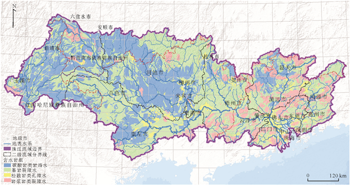
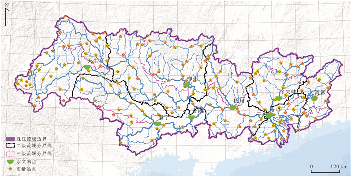
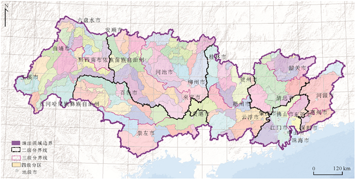
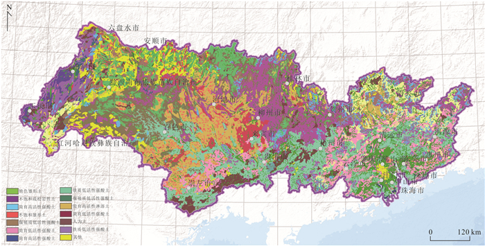
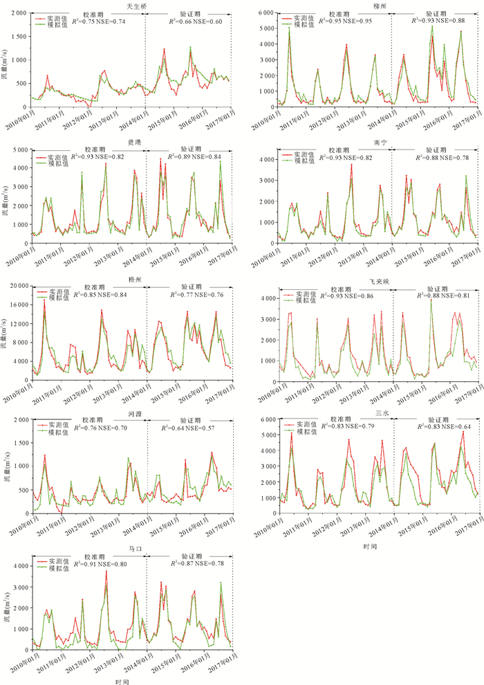
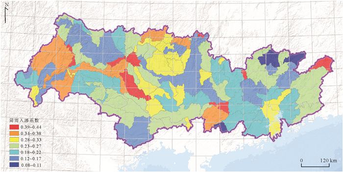
On the basis of reviewing the current situation and history of groundwater resources evaluation in the Pearl River basin, this paper discusses the basic principle and basic database of SWAT distributed hydrological model. We divided the Pearl River basin into 129 four-level groundwater systems, and fully considered the parameter sensitivity of karst, bedrock fissures and pore aquifer media. Based on the monthly measured runoff of 9 hydrological stations from 2008 to 2016, we carried out parameter calibration and model calibration, calculated the rainfall assurance rate in different years according to the rainfall from 1957 to 2017, analyzed and evaluated the multi-year groundwater resources in the Pearl River basin. Finally, we carried out the inversion of rainfall infiltration coefficient and groundwater recharge model parameters. Through this assessment, the average recharge of the Pearl River basin from 2010 to 2016 is 148.802 billion m3, and the total recharge of groundwater in extra dry years (2011), normal years (2010) and high water years (2016) are 71.949 billion m3, 144.682 billion m3 and 178.187 billion m3 respectively, of which the rainfall in high water years is about 1.7 times that in extra dry years, the groundwater recharge is 2.48 times, karst. The total annual recharge of bedrock fissure and pore water bearing medium is 52.991 billion m3, 44.513 billion m3 and 51.298 billion m3 respectively. Through parameter inversion, the average annual groundwater recharge modulus is 10.83 L/s·km2 and the rainfall infiltration coefficient is 0.246, in order to provide data support and scientific services for groundwater development, utilization, treatment and protection in the basin.
On the basis of reviewing the current situation and history of groundwater resources evaluation in the Pearl River basin, this paper discusses the basic principle and basic database of SWAT distributed hydrological model. We divided the Pearl River basin into 129 four-level groundwater systems, and fully considered the parameter sensitivity of karst, bedrock fissures and pore aquifer media. Based on the monthly measured runoff of 9 hydrological stations from 2008 to 2016, we carried out parameter calibration and model calibration, calculated the rainfall assurance rate in different years according to the rainfall from 1957 to 2017, analyzed and evaluated the multi-year groundwater resources in the Pearl River basin. Finally, we carried out the inversion of rainfall infiltration coefficient and groundwater recharge model parameters. Through this assessment, the average recharge of the Pearl River basin from 2010 to 2016 is 148.802 billion m3, and the total recharge of groundwater in extra dry years (2011), normal years (2010) and high water years (2016) are 71.949 billion m3, 144.682 billion m3 and 178.187 billion m3 respectively, of which the rainfall in high water years is about 1.7 times that in extra dry years, the groundwater recharge is 2.48 times, karst. The total annual recharge of bedrock fissure and pore water bearing medium is 52.991 billion m3, 44.513 billion m3 and 51.298 billion m3 respectively. Through parameter inversion, the average annual groundwater recharge modulus is 10.83 L/s·km2 and the rainfall infiltration coefficient is 0.246, in order to provide data support and scientific services for groundwater development, utilization, treatment and protection in the basin.

2024, 49(5): 1891-1906.
doi: 10.3799/dqkx.2021.253
Abstract:
In order to find out the impact of human activities on the hydrological environment of Muli permafrost area, Juhugeng mining area of Muli Coalfield with the most significant human activities in the alpine permafrost area was selected, and the river water of Datong River tributary system in the area was taken as the research object. Based on the spatial characteristics of hydrochemical composition, the research was carried out by using multiple isotopes such as hydrogen, oxygen, carbon, nitrogen, sulfur and strontium. The results show that: (1) The supra-permafrost water is the main supply source of the river water. Human activities such as coal mining and natural gas hydrate drilling destroy the original frozen soil structure and increase the contribution proportion of the supra-permafrost water to river water; (2) The increase of the concentration of main dissolved nutrients (SO42-, NO3- and DOC) in river water is due to the influence of human activities: sulfur and oxygen isotopes reveal that large-scale open-pit mining in coal mine promotes reduced sulfur oxidation, which is the main reason for the increase of SO42- in the supra-permafrost water and river water; Nitrogen and oxygen isotopes show that the high concentration of NO3- in the river comes from livestock manure of free range grazing; DOC mainly comes from soil organic matter produced by plant degradation in alpine meadow, and there are strong microbial activities in the river water in the source area; (3) Except for H2CO3 weathering carbonate rocks, the weathering of carbonate rock and silicate rock participated by sulfuric acid is enhanced under the influence of human activities and coal mining, which further affects the carbon sink of regional rock weathering. The research results provide research ideas for understanding the evolution of hydrological environment in Alpine permafrost area under the influence of human activities, and provide scientific basis for ecological environment protection in Alpine permafrost area.
In order to find out the impact of human activities on the hydrological environment of Muli permafrost area, Juhugeng mining area of Muli Coalfield with the most significant human activities in the alpine permafrost area was selected, and the river water of Datong River tributary system in the area was taken as the research object. Based on the spatial characteristics of hydrochemical composition, the research was carried out by using multiple isotopes such as hydrogen, oxygen, carbon, nitrogen, sulfur and strontium. The results show that: (1) The supra-permafrost water is the main supply source of the river water. Human activities such as coal mining and natural gas hydrate drilling destroy the original frozen soil structure and increase the contribution proportion of the supra-permafrost water to river water; (2) The increase of the concentration of main dissolved nutrients (SO42-, NO3- and DOC) in river water is due to the influence of human activities: sulfur and oxygen isotopes reveal that large-scale open-pit mining in coal mine promotes reduced sulfur oxidation, which is the main reason for the increase of SO42- in the supra-permafrost water and river water; Nitrogen and oxygen isotopes show that the high concentration of NO3- in the river comes from livestock manure of free range grazing; DOC mainly comes from soil organic matter produced by plant degradation in alpine meadow, and there are strong microbial activities in the river water in the source area; (3) Except for H2CO3 weathering carbonate rocks, the weathering of carbonate rock and silicate rock participated by sulfuric acid is enhanced under the influence of human activities and coal mining, which further affects the carbon sink of regional rock weathering. The research results provide research ideas for understanding the evolution of hydrological environment in Alpine permafrost area under the influence of human activities, and provide scientific basis for ecological environment protection in Alpine permafrost area.
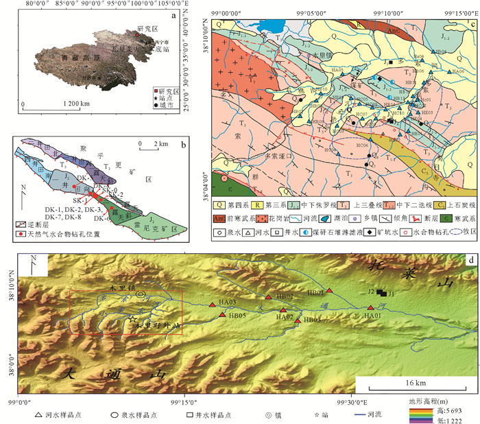
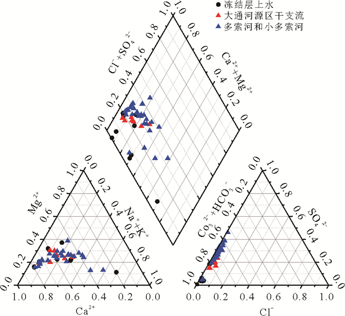
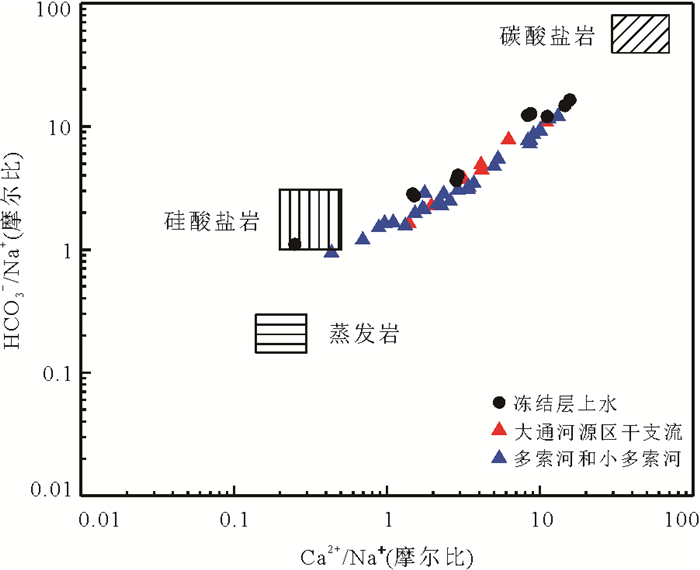
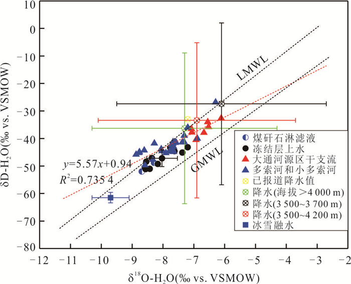
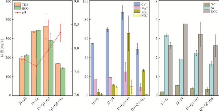
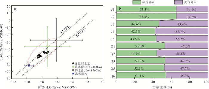
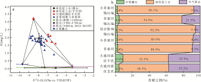
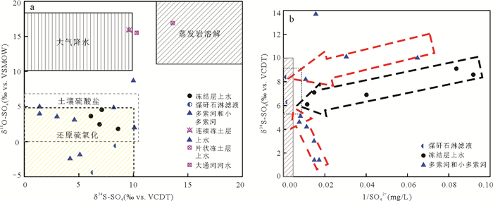
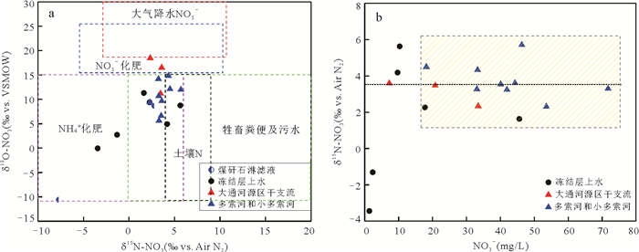
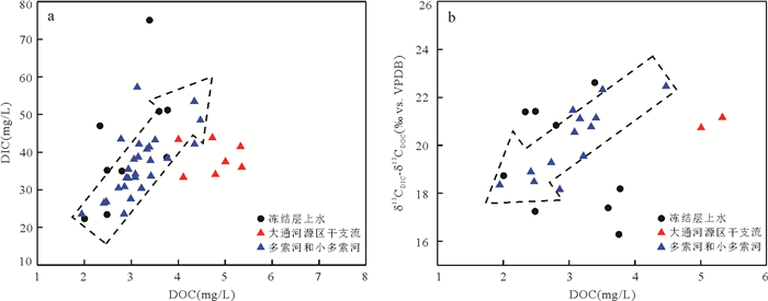
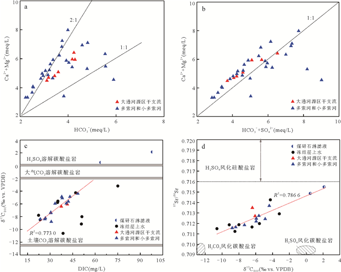
2024, 49(5): 1907-1919.
doi: 10.3799/dqkx.2022.269
Abstract:
In order to understand the interannual variation and control mechanism of carbon fluxes in inland river basins in cold and arid regions, an integrated watershed-scale flux observing network has been constructed for the main ecosystems in the Heihe River basin, including alpine ecosystems in the upper reaches and arid ecosystems in the lower reaches. The observed data analysis indicates that the annual net ecosystem productivity (NEP) and annual gross primary productivity (GPP) were the largest at the cropland site (maize, 729.81 g C/m2/a and 1 184.60 g C/m2/a) and the smallest at the Gobi desert site (94.18 g C/m2/a and 134.97 g C/m2/a) in the Heihe River basin. As to the annual ecosystem respiration (Reco), the wetland ecosystem was the largest (460.22 g C/m2/a), and the Gobi desert ecosystem was the smallest (41.18 g C/m2/a). The explaining capacity of the temperature to GPP, NEP and Reco inter-annual variability is higher in the alpine ecosystems than that in the arid ecosystems. In comparison, the explaining capacity of the soil moisture to GPP, NEP and Reco inter-annual variability is lower in the alpine ecosystems than that in the arid ecosystems. In the upper reaches, GPP, NEP and Reco are positively correlated with GPP, NEP, Reco among sites, but the opposite is true in the middle and down reaches. The shallow soil moisture is positively correlated with NEP, GPP and Reco among all sites in the Heihe River basin. In the upstream, shallow soil moisture is more closely correlated with NEP, GPP and Reco than deep soil moisture, but the deep soil moisture is more closely correlated with NEP, GPP and Reco than shallow soil moisture in the middle and lower reaches.
In order to understand the interannual variation and control mechanism of carbon fluxes in inland river basins in cold and arid regions, an integrated watershed-scale flux observing network has been constructed for the main ecosystems in the Heihe River basin, including alpine ecosystems in the upper reaches and arid ecosystems in the lower reaches. The observed data analysis indicates that the annual net ecosystem productivity (NEP) and annual gross primary productivity (GPP) were the largest at the cropland site (maize, 729.81 g C/m2/a and 1 184.60 g C/m2/a) and the smallest at the Gobi desert site (94.18 g C/m2/a and 134.97 g C/m2/a) in the Heihe River basin. As to the annual ecosystem respiration (Reco), the wetland ecosystem was the largest (460.22 g C/m2/a), and the Gobi desert ecosystem was the smallest (41.18 g C/m2/a). The explaining capacity of the temperature to GPP, NEP and Reco inter-annual variability is higher in the alpine ecosystems than that in the arid ecosystems. In comparison, the explaining capacity of the soil moisture to GPP, NEP and Reco inter-annual variability is lower in the alpine ecosystems than that in the arid ecosystems. In the upper reaches, GPP, NEP and Reco are positively correlated with GPP, NEP, Reco among sites, but the opposite is true in the middle and down reaches. The shallow soil moisture is positively correlated with NEP, GPP and Reco among all sites in the Heihe River basin. In the upstream, shallow soil moisture is more closely correlated with NEP, GPP and Reco than deep soil moisture, but the deep soil moisture is more closely correlated with NEP, GPP and Reco than shallow soil moisture in the middle and lower reaches.
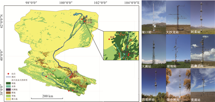
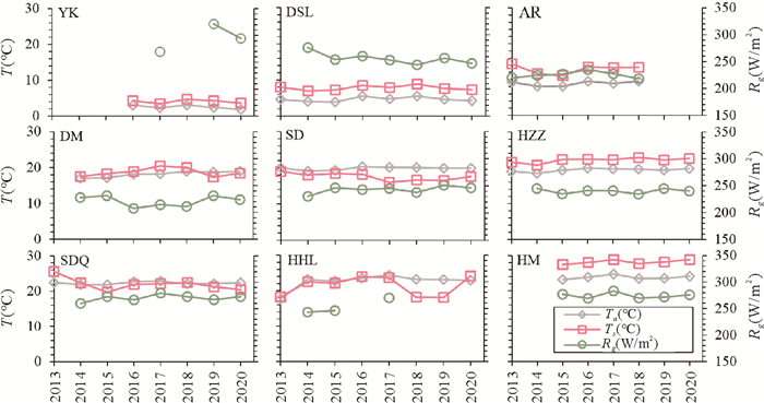
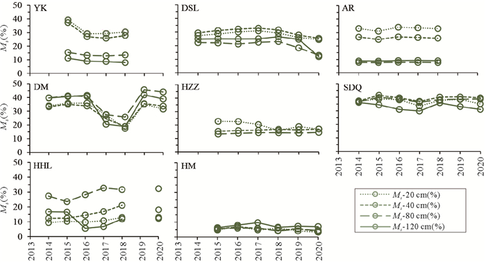
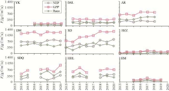
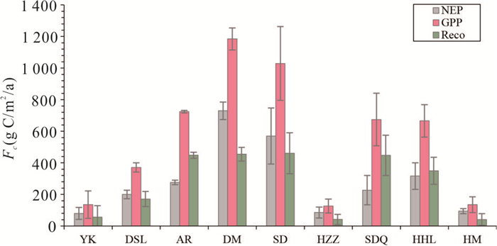
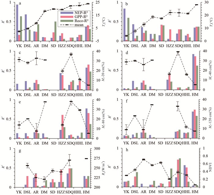
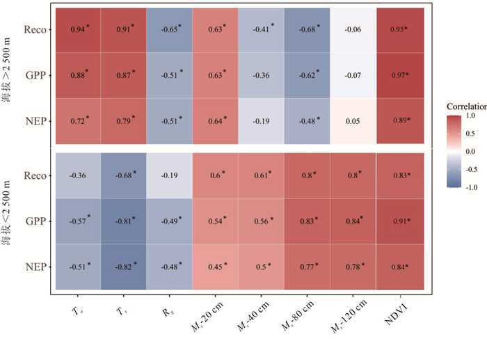
2024, 49(5): 1920-1930.
doi: 10.3799/dqkx.2022.079
Abstract:
Ammonium plays an important role in the biogeochemical cycle of arsenic, but the mechanism of ammonium input on algae-mediated As(Ⅲ) bio-oxidation remains unexplored. The arsenic-resistant cyanobacteria Anabaena sp. was used in this study. Through laboratory simulation experiments, the toxicity, oxidation of different As(Ⅲ)concentrations mediated by Anabaena sp. was investigated. The influences of the input of exogenous ammonium on the growth of Anabaena sp. and the oxidation of As(Ⅲ) were also explored. The results show that the IC50 value of Anabaena sp. was 15.59 mg/L, and 0.1 mg/L, 1 mg/L and 10 mg/L As(Ⅲ) were completely oxidized to As(Ⅴ) within 1 d, 2 d and 7 d, respectively, after inoculating Anabaena sp., With the concentration of As(Ⅲ) increased, the nitrogen fixation effect of Anabaena sp. is enhanced. Furthermore, the growth of Anabaena sp. was promoted within 234 mg/L NH4+. With the increase of NH4+ concentration from 0 mg/L to 1 mg/L, 45 mg/L and 234 mg/L, 1 mg/L As(Ⅲ) was completely oxidized at 48 h, 36 h, 24 h and 12 h, respectively, as the concentration of NH4+ increases, the adsorption of Anabaena sp. to arsenic increases, and the oxidation of As(Ⅲ) accelerates. The research results help to interpret the role of ammonium nitrogen in the process of arsenic biotransformation in natural waters.
Ammonium plays an important role in the biogeochemical cycle of arsenic, but the mechanism of ammonium input on algae-mediated As(Ⅲ) bio-oxidation remains unexplored. The arsenic-resistant cyanobacteria Anabaena sp. was used in this study. Through laboratory simulation experiments, the toxicity, oxidation of different As(Ⅲ)concentrations mediated by Anabaena sp. was investigated. The influences of the input of exogenous ammonium on the growth of Anabaena sp. and the oxidation of As(Ⅲ) were also explored. The results show that the IC50 value of Anabaena sp. was 15.59 mg/L, and 0.1 mg/L, 1 mg/L and 10 mg/L As(Ⅲ) were completely oxidized to As(Ⅴ) within 1 d, 2 d and 7 d, respectively, after inoculating Anabaena sp., With the concentration of As(Ⅲ) increased, the nitrogen fixation effect of Anabaena sp. is enhanced. Furthermore, the growth of Anabaena sp. was promoted within 234 mg/L NH4+. With the increase of NH4+ concentration from 0 mg/L to 1 mg/L, 45 mg/L and 234 mg/L, 1 mg/L As(Ⅲ) was completely oxidized at 48 h, 36 h, 24 h and 12 h, respectively, as the concentration of NH4+ increases, the adsorption of Anabaena sp. to arsenic increases, and the oxidation of As(Ⅲ) accelerates. The research results help to interpret the role of ammonium nitrogen in the process of arsenic biotransformation in natural waters.