2025 Vol. 50, No. 4
Display Method:
2025, 50(4): 1273-1283.
doi: 10.3799/dqkx.2022.359
 PDF 19549KB
Abstract:
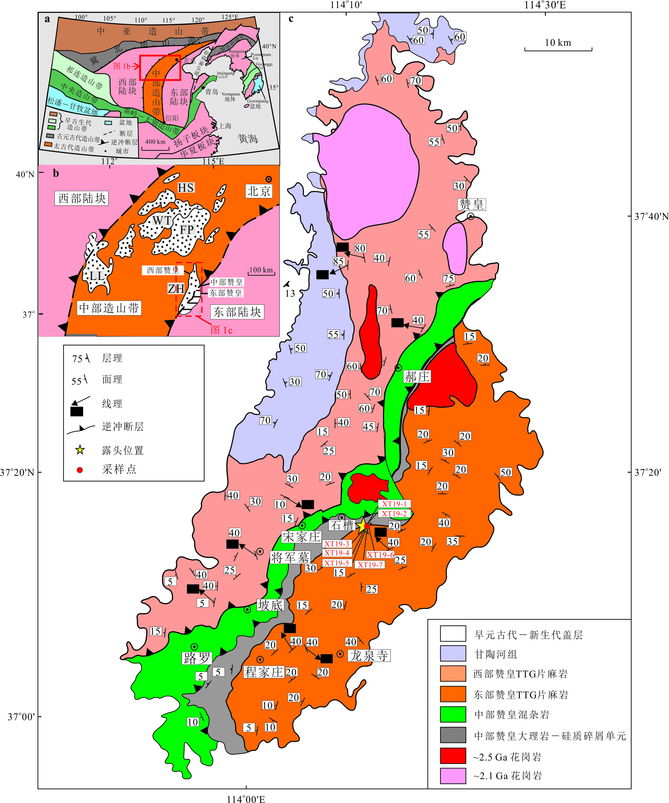
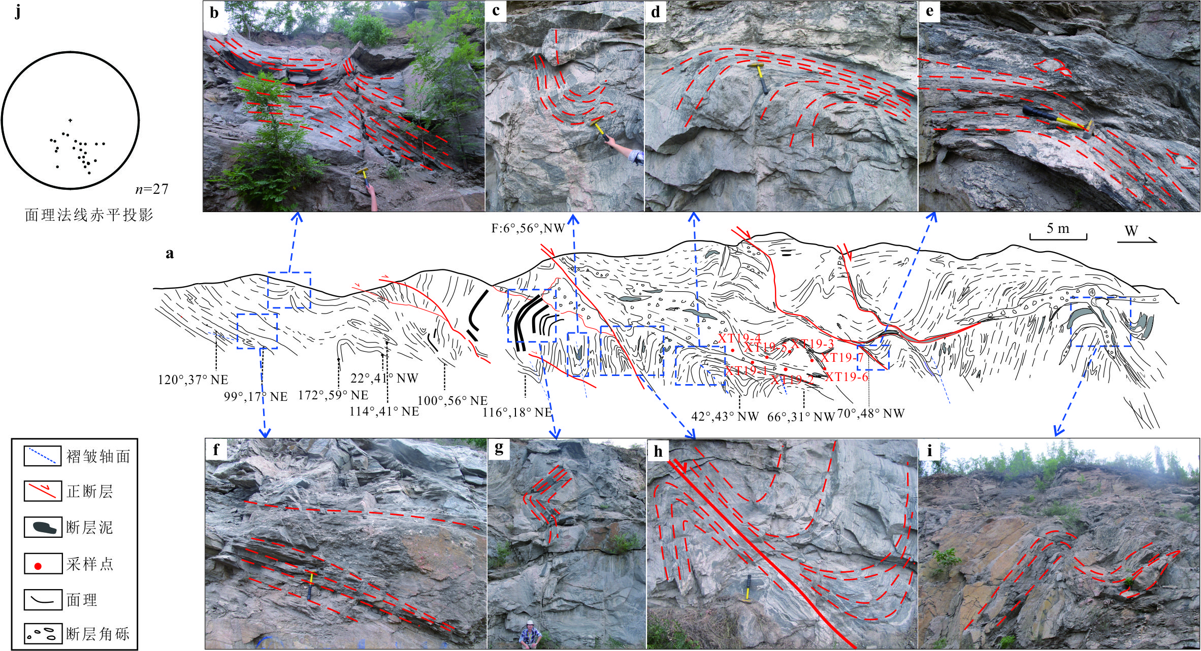
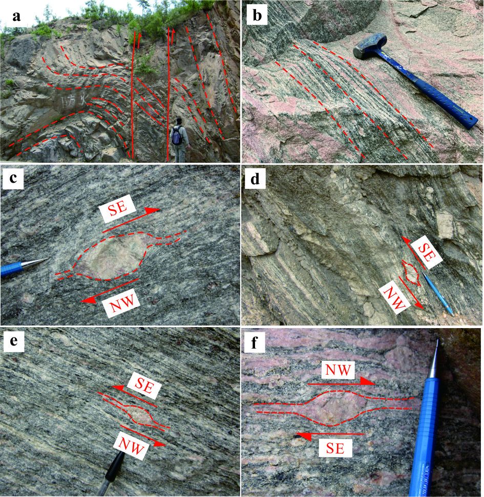
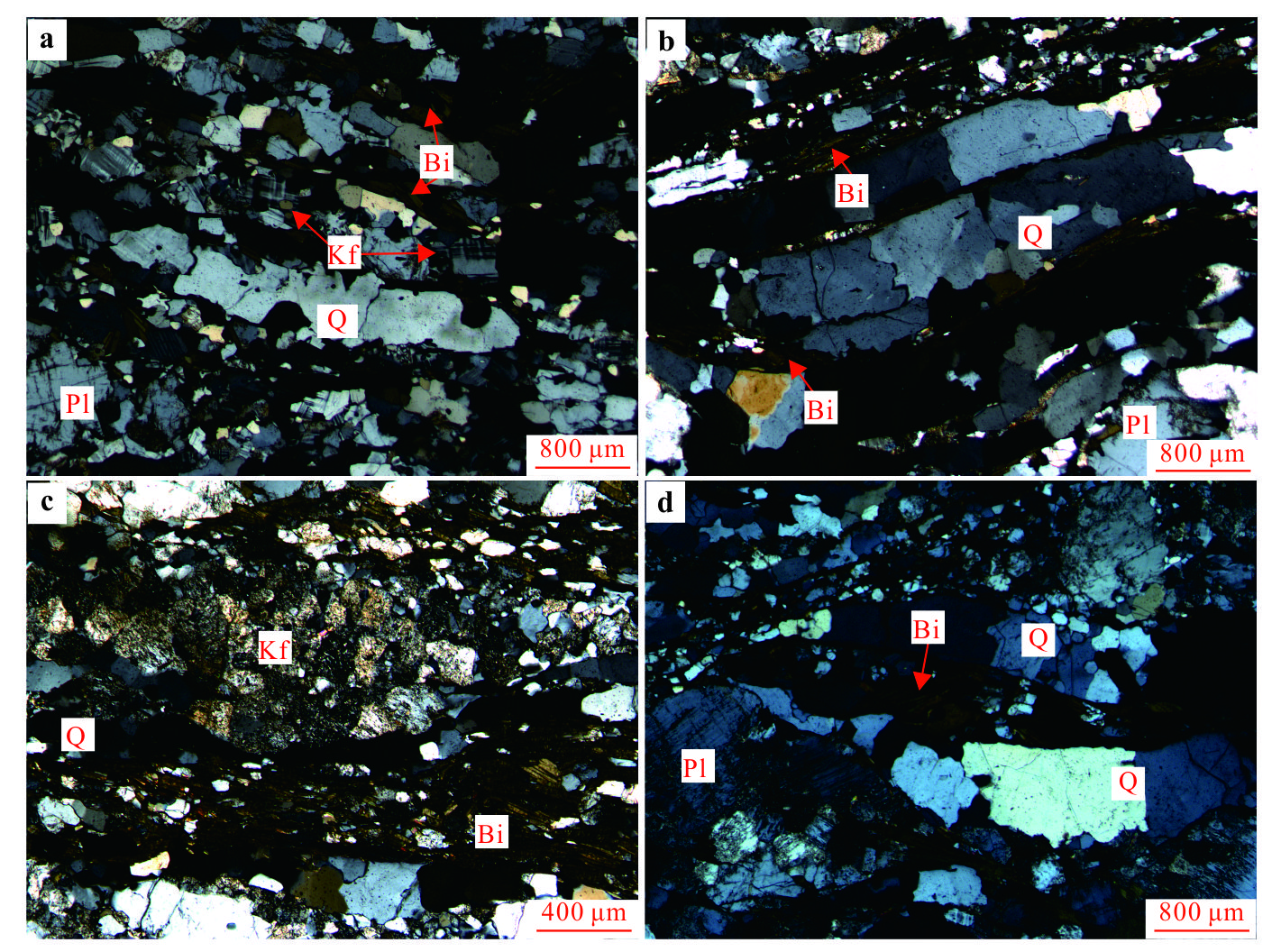
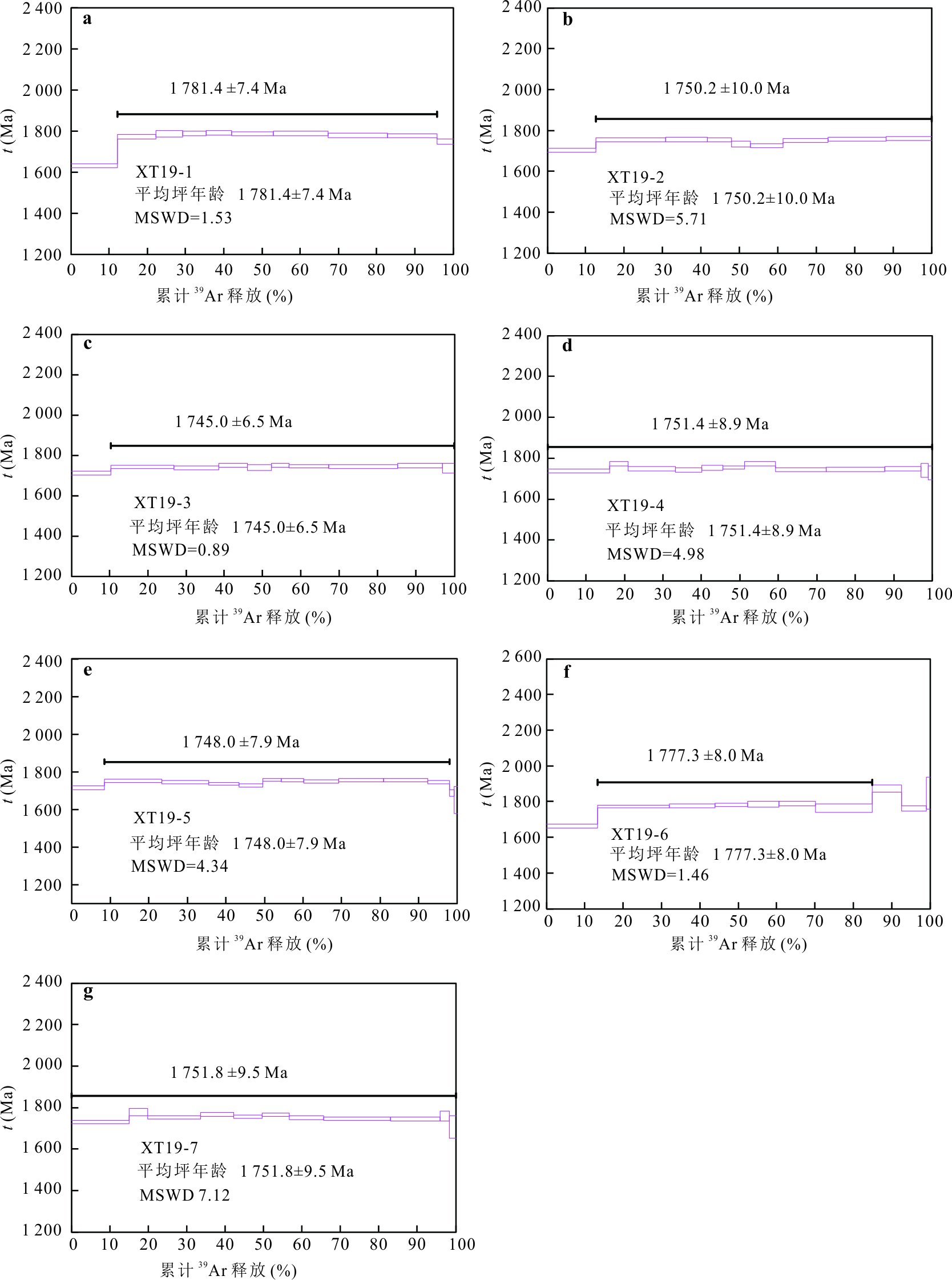
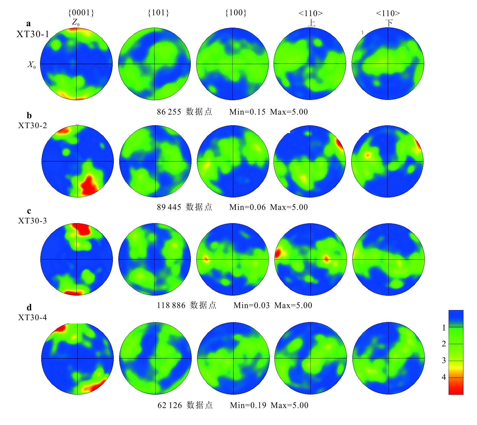
The Zanhuang massif is located in the southeast part of the Central Orogenic Belt of the North China Craton, with complex rock association and tectonic deformation from Archaean to Paleoproterozoic. It is important to study the Early Precambrian tectono-thermal evolution of the Central Orogenic Belt of the North China Craton. In this study, a large-scale rock structure mapping, petrography, biotite 39Ar-40Ar geochronology and quartz EBSD fabric analysis of a well-out cropping ductile shear zone in the Zanhuang massif were carried out to define the kinematic characteristics and formation age of the shear zone, and to further explore the Paleoproterozoic tectono-thermal evolution of the North China Craton. The main lithology of the ductile shear zone is granitic mylonite, mainly composed of quartz (30%-40%), biotite (5%-15%) and feldspar (35%-55%). In the study area, the rocks are strongly deformed and metamorphosed, and a series of normal faults, folds, lineaments, foliations, and rotated porphyroblasts are developed. The surface occurrence and the trail of rotating patches all indicate the NW-SE shear. A plateau age of 1 781-1 745 Ma for biotite in mylonite was obtained by argon age test, indicating that the shear zone was formed in the Late Paleoproterozoic. EBSD fabric of quartz in mylonite shows that the quartz is mainly underside a-slip, indicating that the deformation temperature is lower than 400 ℃. Based on the previous research results, this study shows that the Zanhuang metamorphic complex experienced a strong disturbance caused by a tectono-thermal event in the Late Paleoproterozoic.
The Zanhuang massif is located in the southeast part of the Central Orogenic Belt of the North China Craton, with complex rock association and tectonic deformation from Archaean to Paleoproterozoic. It is important to study the Early Precambrian tectono-thermal evolution of the Central Orogenic Belt of the North China Craton. In this study, a large-scale rock structure mapping, petrography, biotite 39Ar-40Ar geochronology and quartz EBSD fabric analysis of a well-out cropping ductile shear zone in the Zanhuang massif were carried out to define the kinematic characteristics and formation age of the shear zone, and to further explore the Paleoproterozoic tectono-thermal evolution of the North China Craton. The main lithology of the ductile shear zone is granitic mylonite, mainly composed of quartz (30%-40%), biotite (5%-15%) and feldspar (35%-55%). In the study area, the rocks are strongly deformed and metamorphosed, and a series of normal faults, folds, lineaments, foliations, and rotated porphyroblasts are developed. The surface occurrence and the trail of rotating patches all indicate the NW-SE shear. A plateau age of 1 781-1 745 Ma for biotite in mylonite was obtained by argon age test, indicating that the shear zone was formed in the Late Paleoproterozoic. EBSD fabric of quartz in mylonite shows that the quartz is mainly underside a-slip, indicating that the deformation temperature is lower than 400 ℃. Based on the previous research results, this study shows that the Zanhuang metamorphic complex experienced a strong disturbance caused by a tectono-thermal event in the Late Paleoproterozoic.
2025, 50(4): 1284-1304.
doi: 10.3799/dqkx.2024.091
Abstract:
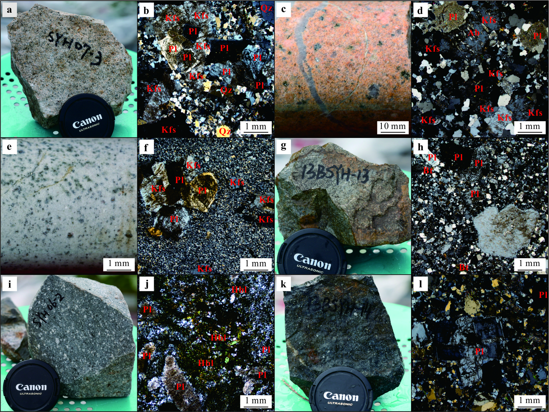
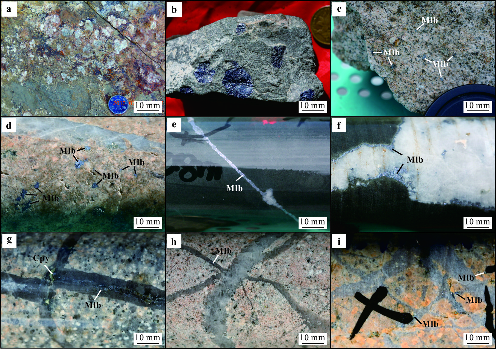
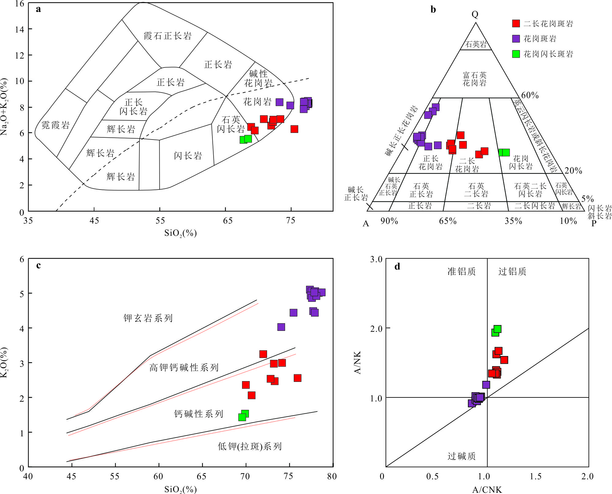
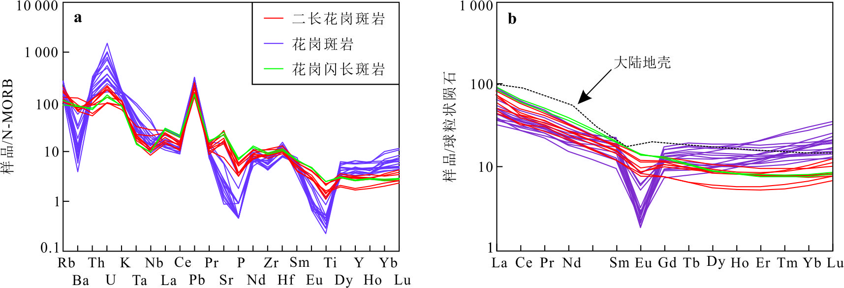
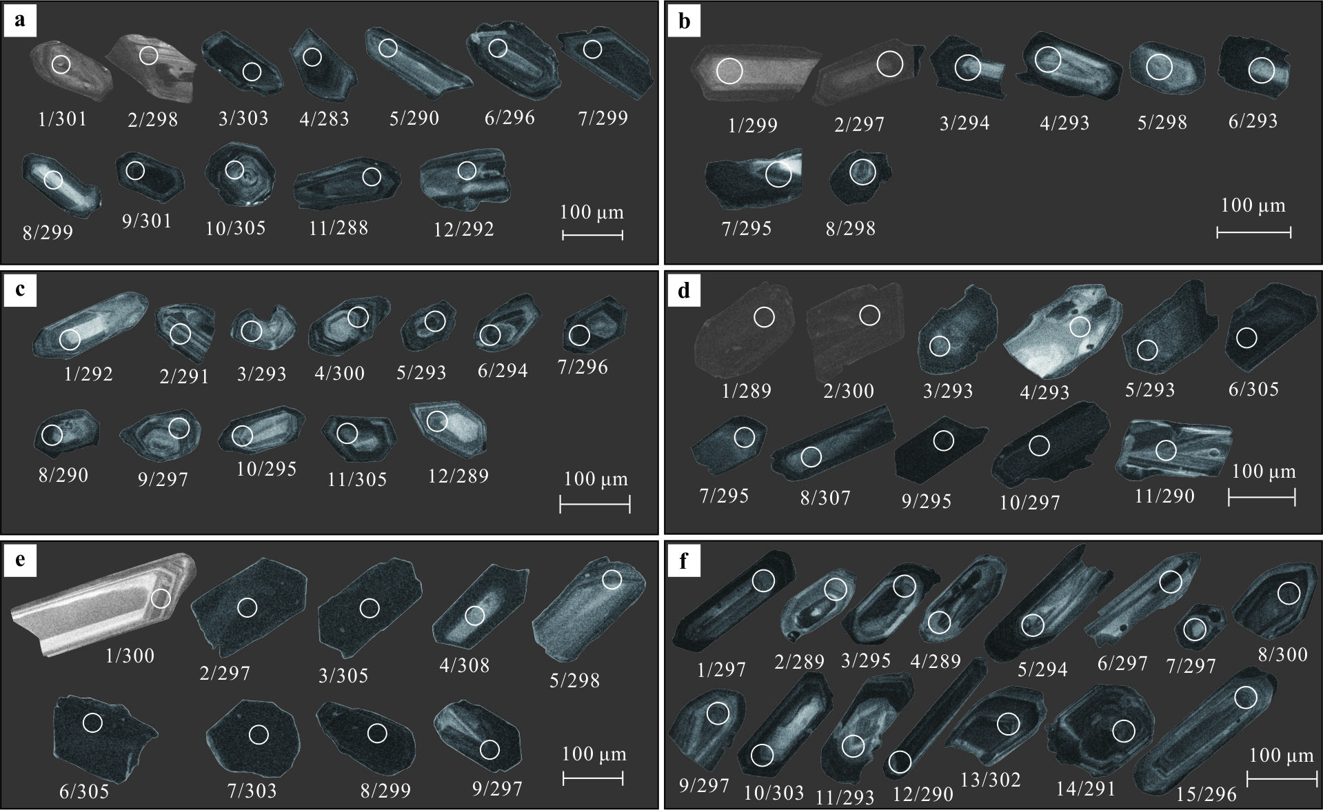
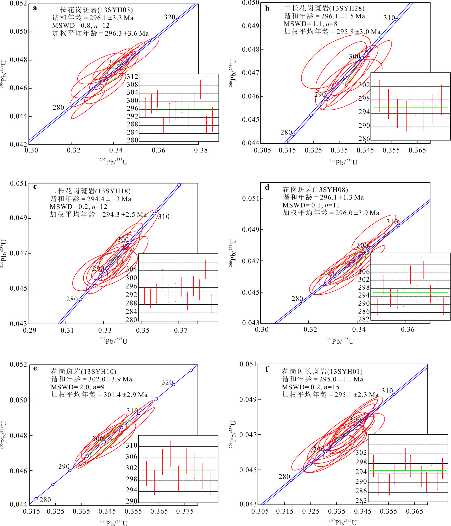
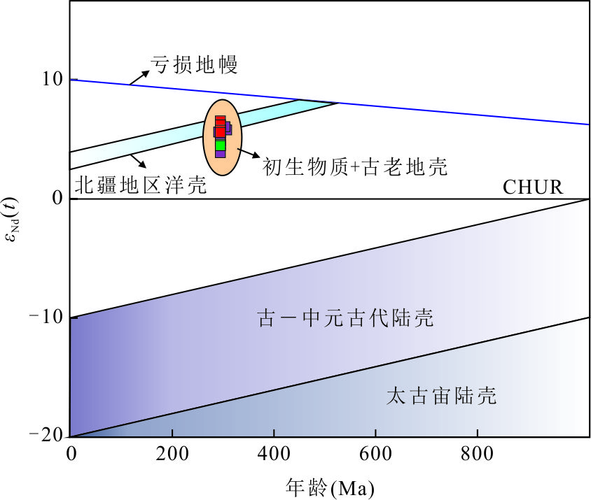
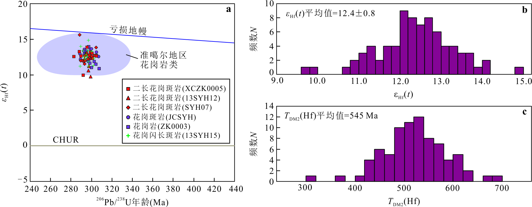
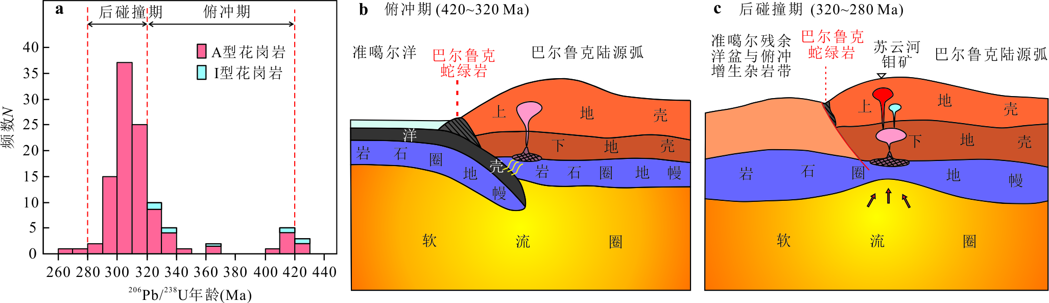
The Suyunhe molybdenum deposit is a super large porphyry deposit located in the western Junggar region within the Central Asian Orogenic Belt. The mineralized rocks are monzogranite porphyry and granodiorite porphyry that intruded into the volcaniclastic rock of the Devonian Barluk Formation. In this paper, it reports a detailed study on the petrography, elemental and isotope geochemistry, and geochronology of mineralized rocks from the Suyunhe molybdenum deposit. The results reveal follows. (1) The monzogranite porphyry, granite porphyry, and granodiorite porphyry formed between 294 and 302 Ma as a result of prolonged magmatic-hydrothermal evolution that resulted in mineralization. (2) The monzogranite porphyry, granite porphyry, and granodiorite porphyry are thought to have originated from a common magma source, undergoing varying degrees of crystallization differentiation. This is evidenced by the correlated variations in their major and trace element contents, as well as their uniform Sr-Nd-Hf isotopic signatures. (3) These granitoids are enriched in Rb, U, Th, Nd, and Hf and depleted in Ba, Nb, Ti, and P, exhibiting geochemical characteristics of granites in a post-collisional setting. (4) Elevated Sr content (averaging 202.41×10⁻⁶) along with a high Sr/Y ratio (averaging 14.97), moderate εNd(t) values (+3.8 to +6.0), and high zircon εHf(t) values (+9.7 to +15.6) suggest that the magma from the Suyunhe mineral district primarily originated from the melting and mixing of juvenile mantle materials with a minor proportion of ancient crustal materials.
The Suyunhe molybdenum deposit is a super large porphyry deposit located in the western Junggar region within the Central Asian Orogenic Belt. The mineralized rocks are monzogranite porphyry and granodiorite porphyry that intruded into the volcaniclastic rock of the Devonian Barluk Formation. In this paper, it reports a detailed study on the petrography, elemental and isotope geochemistry, and geochronology of mineralized rocks from the Suyunhe molybdenum deposit. The results reveal follows. (1) The monzogranite porphyry, granite porphyry, and granodiorite porphyry formed between 294 and 302 Ma as a result of prolonged magmatic-hydrothermal evolution that resulted in mineralization. (2) The monzogranite porphyry, granite porphyry, and granodiorite porphyry are thought to have originated from a common magma source, undergoing varying degrees of crystallization differentiation. This is evidenced by the correlated variations in their major and trace element contents, as well as their uniform Sr-Nd-Hf isotopic signatures. (3) These granitoids are enriched in Rb, U, Th, Nd, and Hf and depleted in Ba, Nb, Ti, and P, exhibiting geochemical characteristics of granites in a post-collisional setting. (4) Elevated Sr content (averaging 202.41×10⁻⁶) along with a high Sr/Y ratio (averaging 14.97), moderate εNd(t) values (+3.8 to +6.0), and high zircon εHf(t) values (+9.7 to +15.6) suggest that the magma from the Suyunhe mineral district primarily originated from the melting and mixing of juvenile mantle materials with a minor proportion of ancient crustal materials.

2025, 50(4): 1305-1318.
doi: 10.3799/dqkx.2024.120
Abstract:
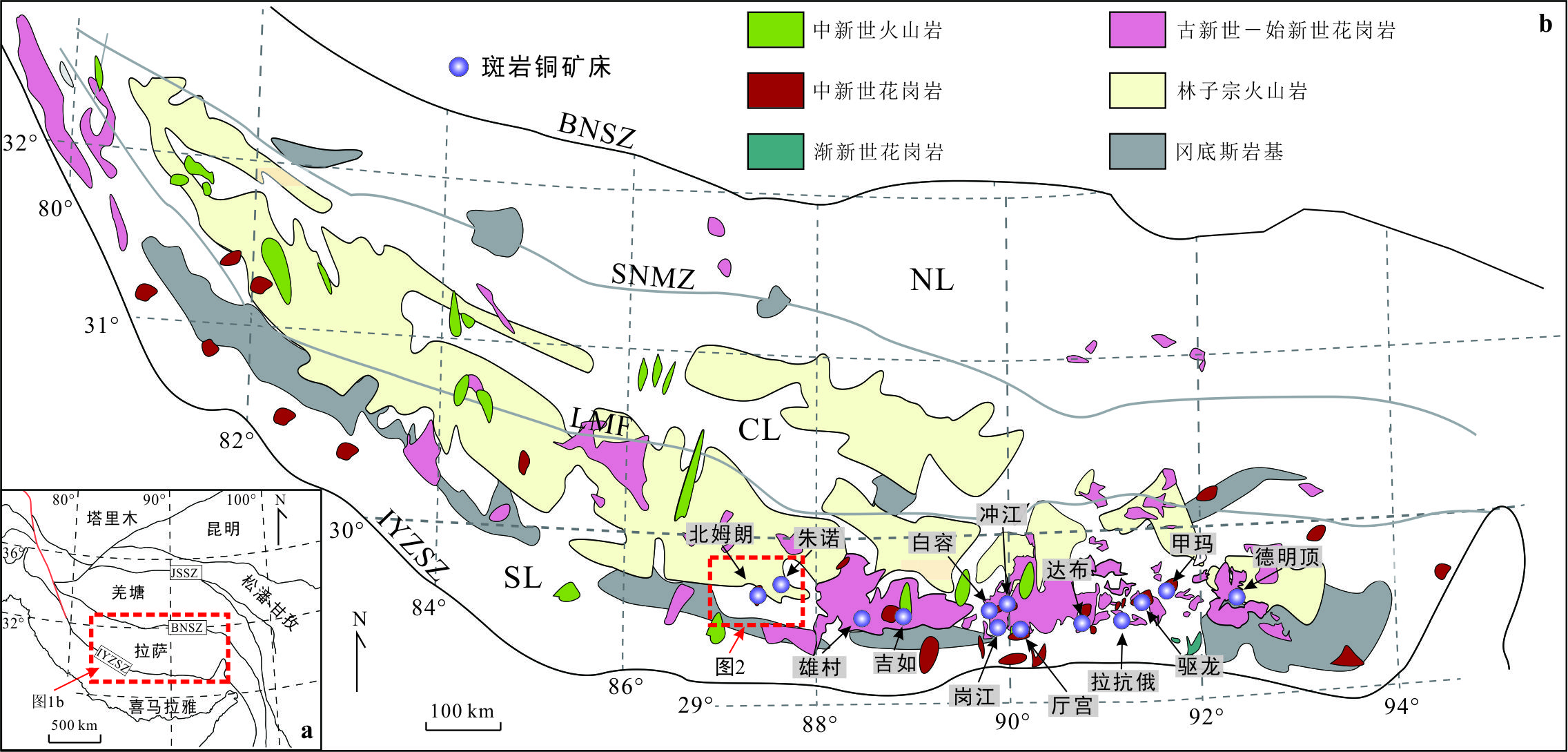
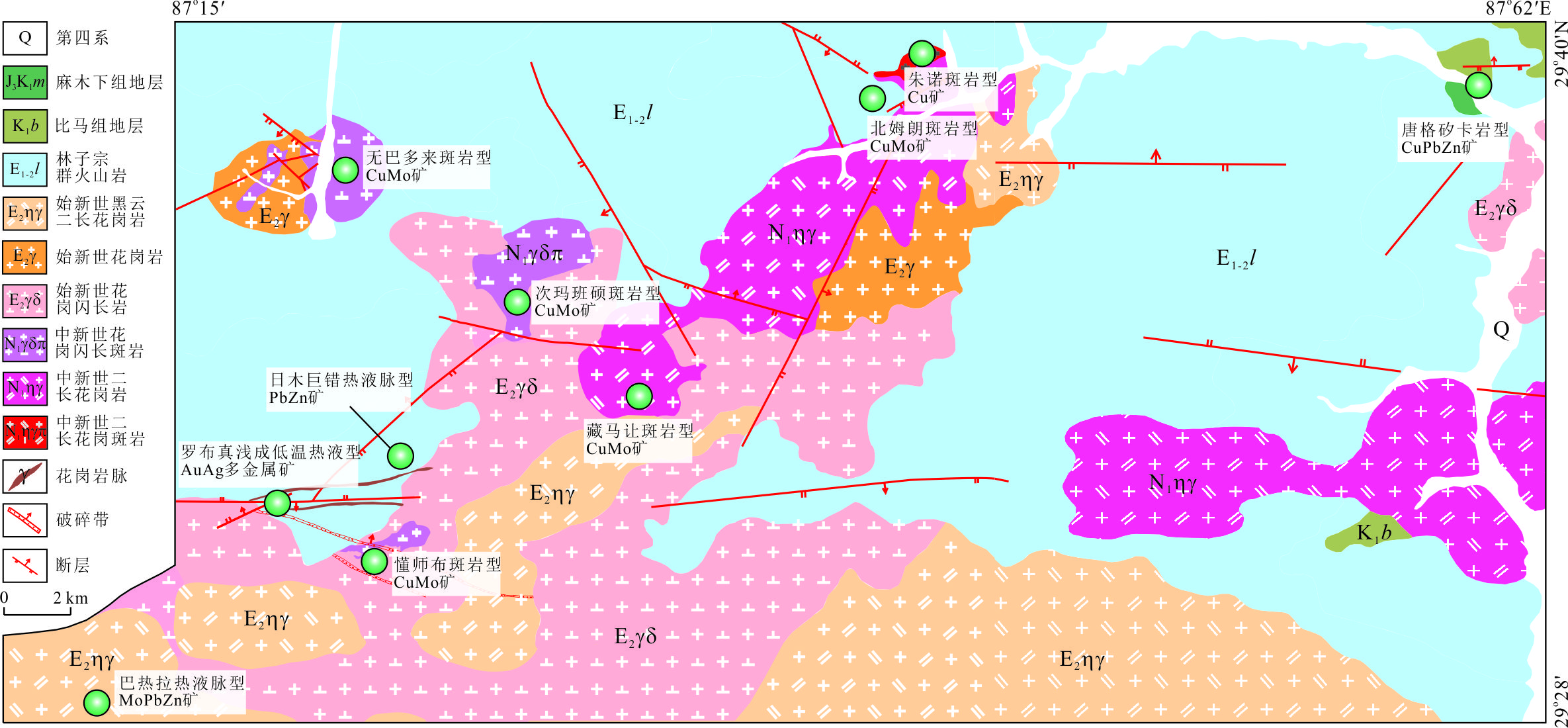
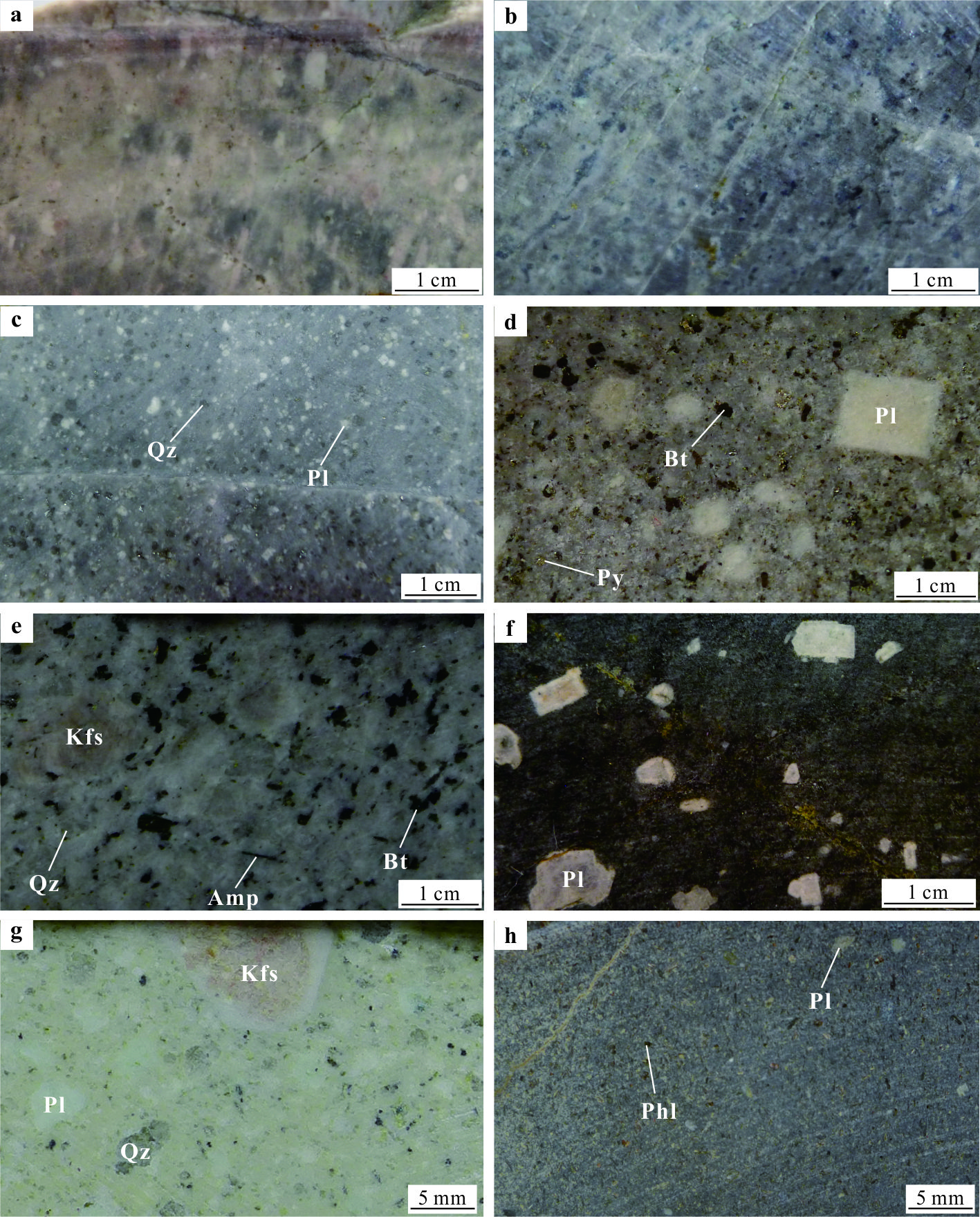
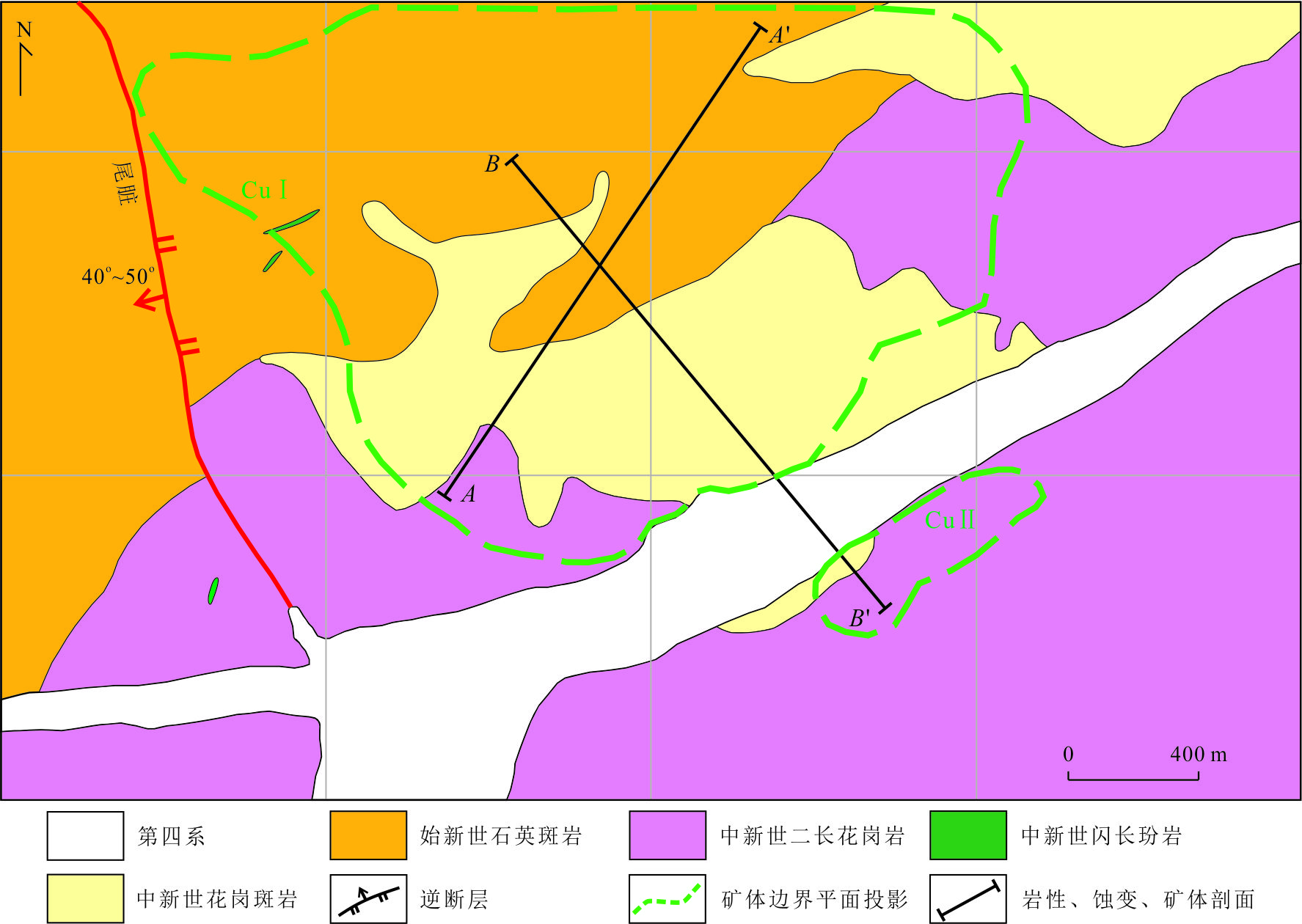
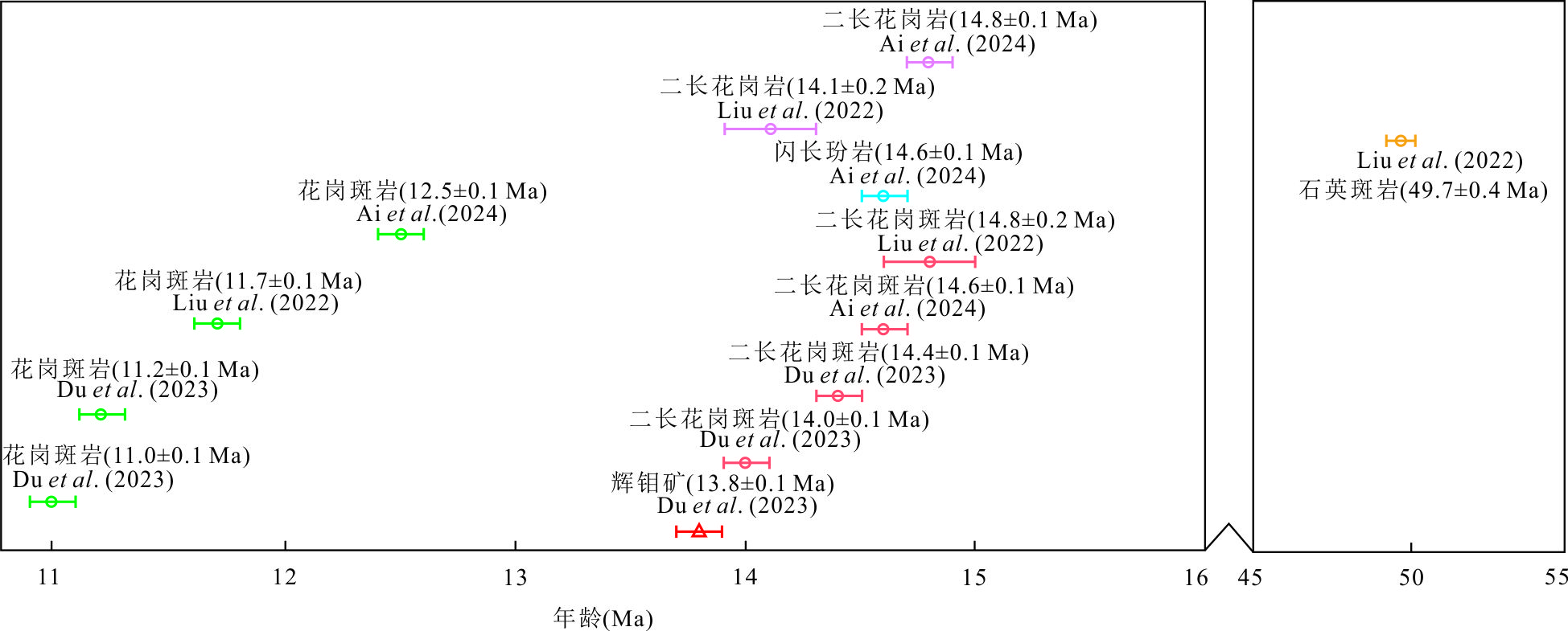
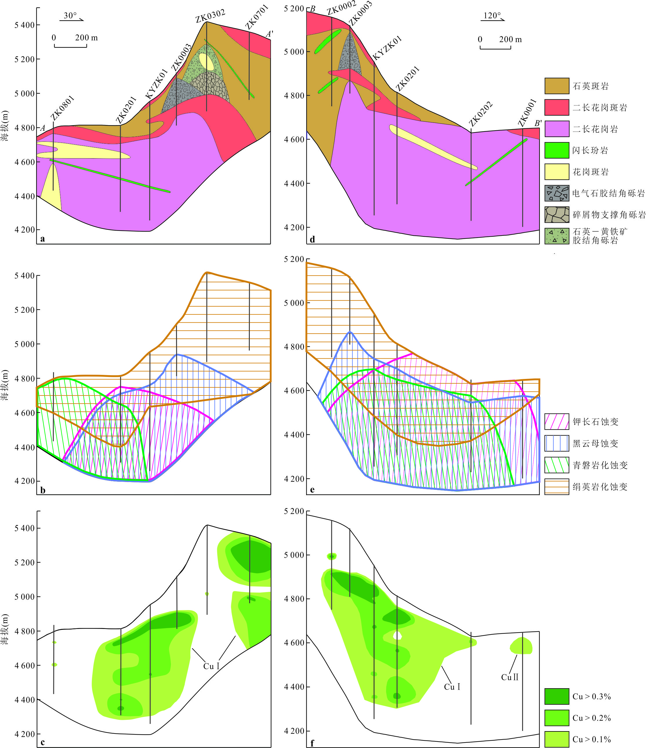
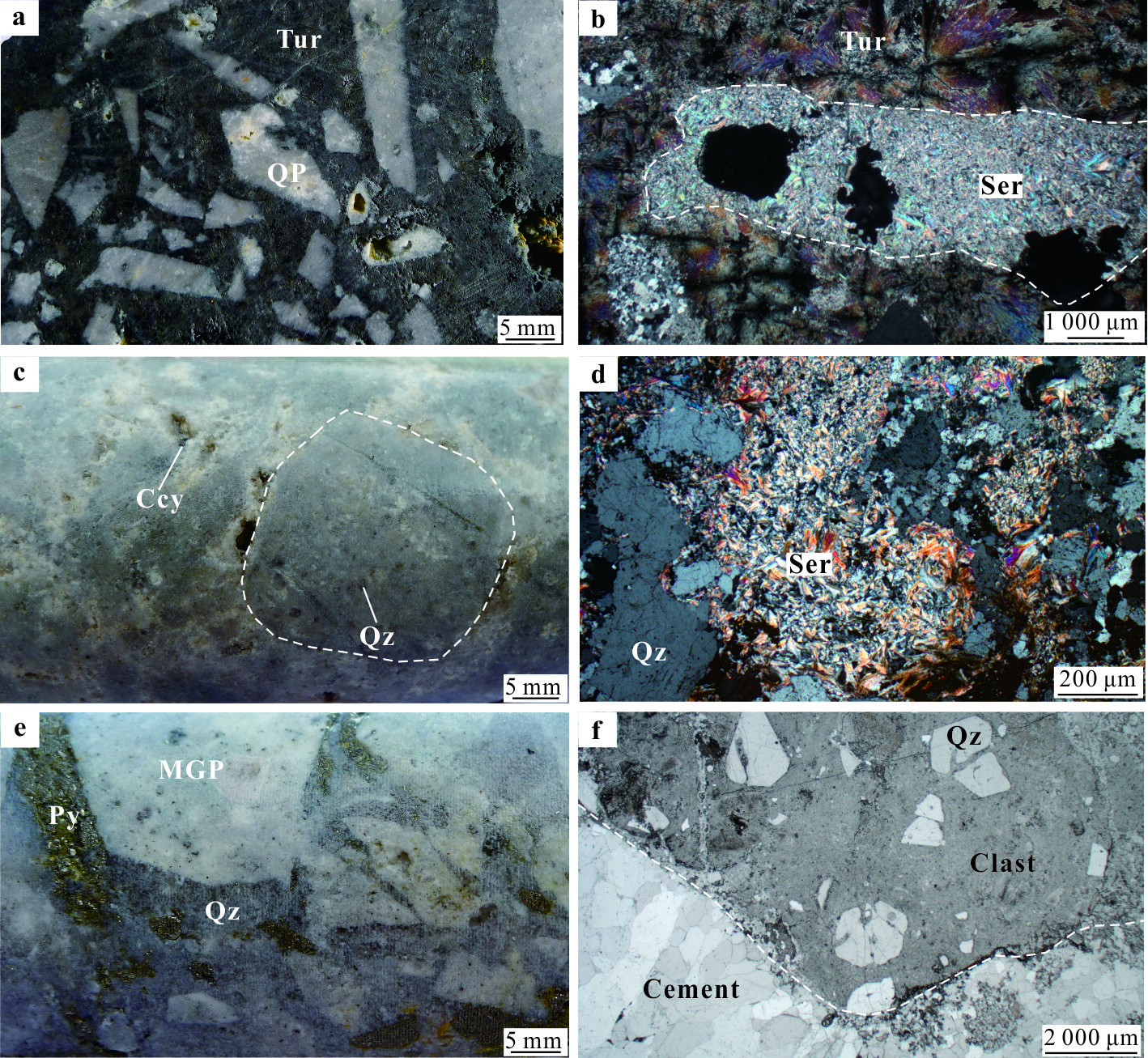
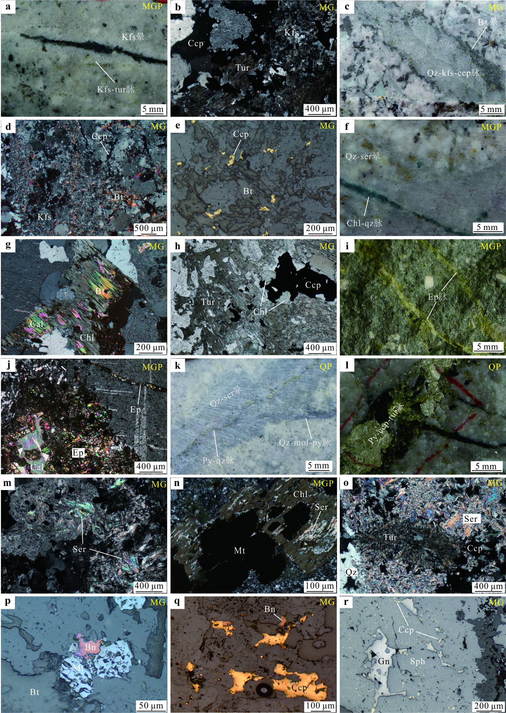
The Zhunuo ore concentration district is located in the western Gangdese metallogenic belt, Xizang. The area contains a large NE-SW geochemistry anomaly, which exhibits favorable metallogenic conditions and is a key block for the deployment of a new round of breakthrough strategic actions in mineral exploration. The Beimulang deposit is a newly discovered porphyry Cu-Mo deposit after the Zhunuo deposit in the area. Beimulang contains a mental reserve of 1.3 million tons averaging 0.51% Cu. Magmatic activity in the deposit is strong, including pre-mineralization quartz porphyry (~49.7 Ma), inter-mineralization monzogranite porphyry(~14.8-14.0 Ma), monzogranite(~14.1 Ma), diorite porphyry, and late-mineralization granite porphyry (~11.0-11.7 Ma), lamprophyre. Mineralization occurs mainly in the main inter-mineralization and pre-mineralization intrusions. Molybdenite Re-Os dating shows that main-stage mineralization at Beimulang formed in 13.8±0.1 Ma. Three breccia types have been observed in the deposit, typically located in the apical parts of monzogranite porphyry: (1) tourmaline-cemented breccia, (2) clast-supported breccia, and (3) quartz-pyrite-cemented breccia. Hydrothermal alteration is strongly developed and includes central potassic, peripheral propylitic, and shallow phyllic alteration. The three kinds of alteration are superimposed on each other. Biotite alteration is most closely associated with Cu mineralization. The discovery of the Beimulang deposit confirms the prevailing view that large and super-large porphyry Cu deposits can be formed in areas that cannot be formed or have low ore-forming potential, which provides a new example for further study of the porphyry mineralization process and deep metallogenic mechanism in collision orogenic belt. The discovery of the Beimulang Cu-Mo deposit is attributed to the demonstration of comprehensive exploration methods such as geology, stream sediment geochemical, and hyperspectral analysis. In particular, short-wave infrared spectroscopy technology can effectively trace hydrothermal/mineralization centers. The discovery of the deposit has pointed out the direction for searching for similar deposits in the region and also provided important support for the Zhunuo ore concentration district to become another new ten million tons of copper resource base in China.
The Zhunuo ore concentration district is located in the western Gangdese metallogenic belt, Xizang. The area contains a large NE-SW geochemistry anomaly, which exhibits favorable metallogenic conditions and is a key block for the deployment of a new round of breakthrough strategic actions in mineral exploration. The Beimulang deposit is a newly discovered porphyry Cu-Mo deposit after the Zhunuo deposit in the area. Beimulang contains a mental reserve of 1.3 million tons averaging 0.51% Cu. Magmatic activity in the deposit is strong, including pre-mineralization quartz porphyry (~49.7 Ma), inter-mineralization monzogranite porphyry(~14.8-14.0 Ma), monzogranite(~14.1 Ma), diorite porphyry, and late-mineralization granite porphyry (~11.0-11.7 Ma), lamprophyre. Mineralization occurs mainly in the main inter-mineralization and pre-mineralization intrusions. Molybdenite Re-Os dating shows that main-stage mineralization at Beimulang formed in 13.8±0.1 Ma. Three breccia types have been observed in the deposit, typically located in the apical parts of monzogranite porphyry: (1) tourmaline-cemented breccia, (2) clast-supported breccia, and (3) quartz-pyrite-cemented breccia. Hydrothermal alteration is strongly developed and includes central potassic, peripheral propylitic, and shallow phyllic alteration. The three kinds of alteration are superimposed on each other. Biotite alteration is most closely associated with Cu mineralization. The discovery of the Beimulang deposit confirms the prevailing view that large and super-large porphyry Cu deposits can be formed in areas that cannot be formed or have low ore-forming potential, which provides a new example for further study of the porphyry mineralization process and deep metallogenic mechanism in collision orogenic belt. The discovery of the Beimulang Cu-Mo deposit is attributed to the demonstration of comprehensive exploration methods such as geology, stream sediment geochemical, and hyperspectral analysis. In particular, short-wave infrared spectroscopy technology can effectively trace hydrothermal/mineralization centers. The discovery of the deposit has pointed out the direction for searching for similar deposits in the region and also provided important support for the Zhunuo ore concentration district to become another new ten million tons of copper resource base in China.
2025, 50(4): 1319-1334.
doi: 10.3799/dqkx.2024.092
Abstract:
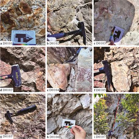
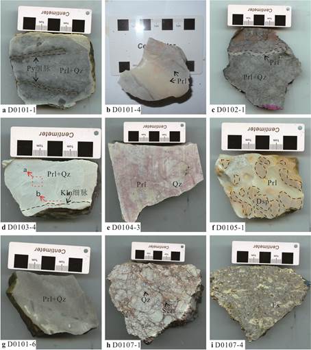
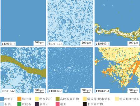
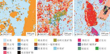
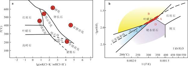
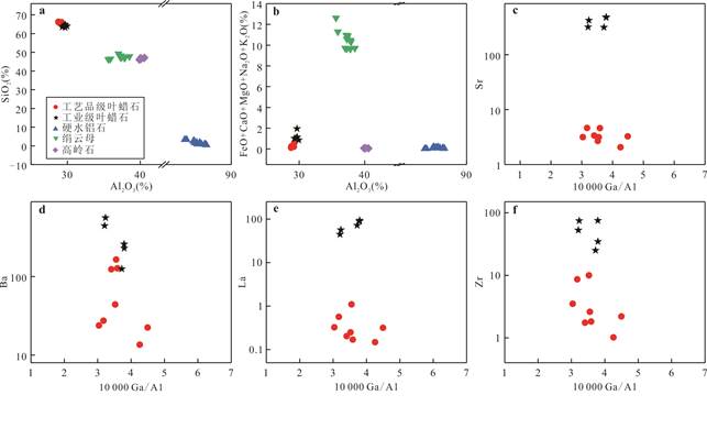
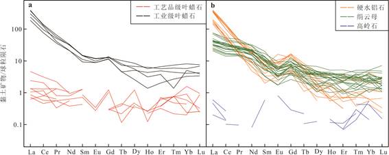
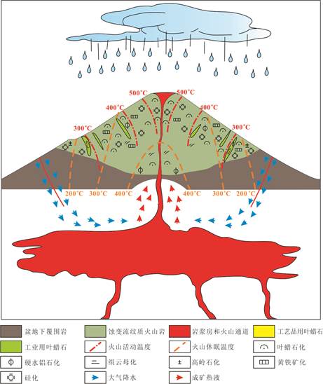
Currently, pyrophyllite is one of the most important raw materials for a variety of new functional products. In China, hydrothermal pyrophyllite constitutes a significant proportion. Therefore, enhancing the genesis model of hydrothermal pyrophyllite deposit is essential for ensuring a long-term stable supply of industrial raw materials for the manufacturing industry focused on new functional materials. This study involved a systematic profile survey and sampling at the Jialiangshan pyrophyllite deposit. The TESCAN integrated mineral analyzer (TIMA), electron probe micro-analysis (EPMA) and laser ablation inductively coupled plasma mass spectrometry (LA-ICP-MS) were utilized to quantitatively determine the mineral composition and elemental characteristics of alteration minerals. Mineral assemblages in different ores were analyzed to determine their genesis conditions based on the result of alteration zoning results. The elemental composition of clay minerals including pyrophyllite, diaspore, sericite and kaolinite were specifically determined to understand the elemental behavior during the alteration process. Results from field investigation and quantitative analysis indicate that the alteration assemblage within the Jialiangshan pyrophyllite deposit exhibits spatial distribution, characterized by a gradual decrease in alteration temperature from the crater outwards. Our study suggests that the formation of Jaliangshan pyrophyllite deposit is linked to volcanic activity followed by an extended sequence of hydrothermal alteration processes. Following extensive alteration, element migration between surrounding rock and the hydrothermal fluid resulted in large-scale pyrophyllite deposits for industrial raw materials. The conditions necessary for the forming artefact pyrophyllite within the ore-body are more stringent; the hydrothermal fluid should be unsaturated with SiO2 at temperatures maintained between 273 and 370 ℃ along with fractures providing space for growth.
Currently, pyrophyllite is one of the most important raw materials for a variety of new functional products. In China, hydrothermal pyrophyllite constitutes a significant proportion. Therefore, enhancing the genesis model of hydrothermal pyrophyllite deposit is essential for ensuring a long-term stable supply of industrial raw materials for the manufacturing industry focused on new functional materials. This study involved a systematic profile survey and sampling at the Jialiangshan pyrophyllite deposit. The TESCAN integrated mineral analyzer (TIMA), electron probe micro-analysis (EPMA) and laser ablation inductively coupled plasma mass spectrometry (LA-ICP-MS) were utilized to quantitatively determine the mineral composition and elemental characteristics of alteration minerals. Mineral assemblages in different ores were analyzed to determine their genesis conditions based on the result of alteration zoning results. The elemental composition of clay minerals including pyrophyllite, diaspore, sericite and kaolinite were specifically determined to understand the elemental behavior during the alteration process. Results from field investigation and quantitative analysis indicate that the alteration assemblage within the Jialiangshan pyrophyllite deposit exhibits spatial distribution, characterized by a gradual decrease in alteration temperature from the crater outwards. Our study suggests that the formation of Jaliangshan pyrophyllite deposit is linked to volcanic activity followed by an extended sequence of hydrothermal alteration processes. Following extensive alteration, element migration between surrounding rock and the hydrothermal fluid resulted in large-scale pyrophyllite deposits for industrial raw materials. The conditions necessary for the forming artefact pyrophyllite within the ore-body are more stringent; the hydrothermal fluid should be unsaturated with SiO2 at temperatures maintained between 273 and 370 ℃ along with fractures providing space for growth.
2025, 50(4): 1335-1352.
doi: 10.3799/dqkx.2023.200
Abstract:
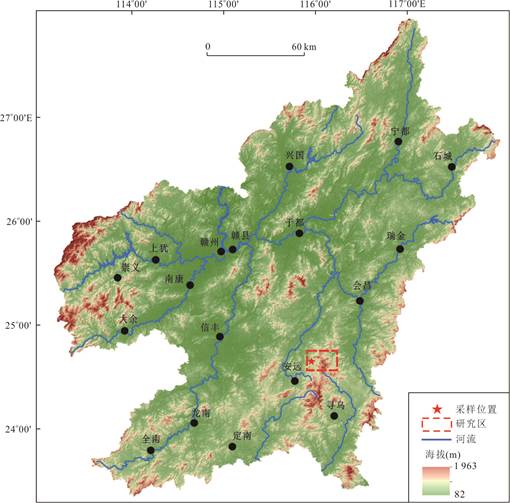
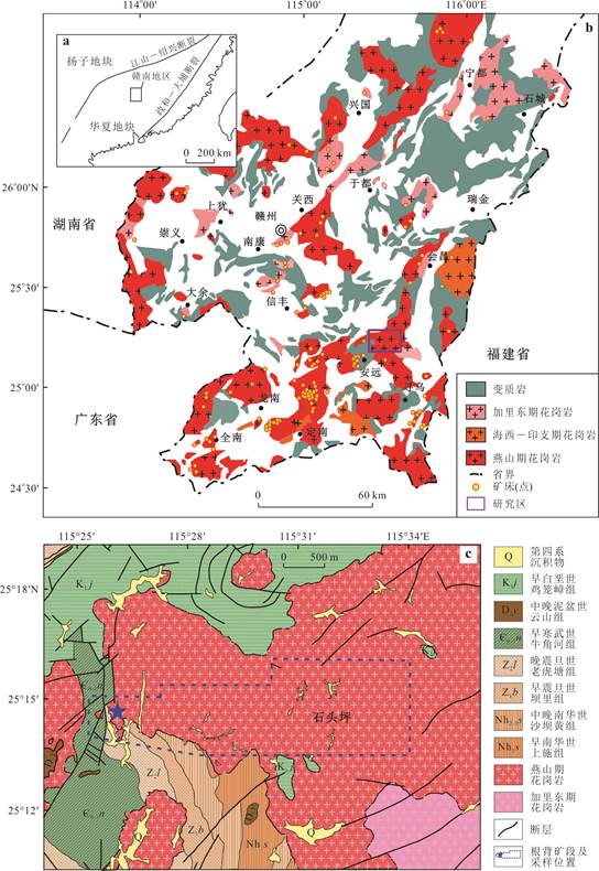
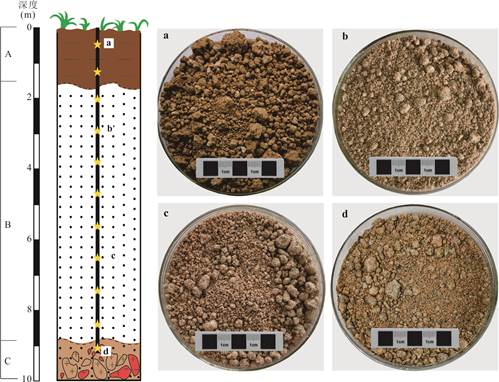
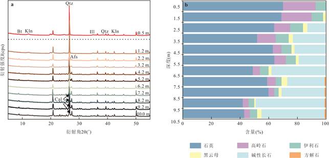
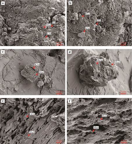
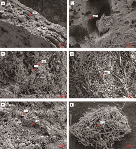
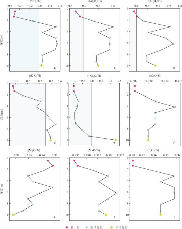
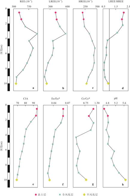
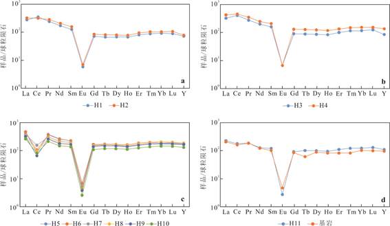
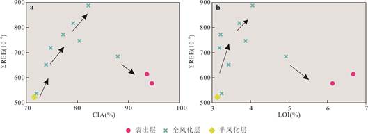
Rare earth elements (REE) are strategic metals worldwide. Regolith-hosted heavy rare earth element (HREE) deposits are the world's main HREE producer, and their genesis is widely debated.The Shitouping HREE deposit is a newly discovered giant regolith-hosted HREE deposit in Ganzhou, Jiangxi, and its genesis is still unclear.Therefore, it carried out systematic sampling within a weathered crust profile from top to bottom using the Gannan drill, and revealed the mineralogy, elemental geochemistry, and pH characteristics of the profile using the X-ray diffraction, scanning electron microscopy, X-ray fluorescence spectroscopy, and inductively coupled plasma mass spectrometry. The results show that the species and morphology of clay minerals in the regolith profile exhibit zonality.Topsoil layer and upper completely weathered zone are mainly composed of highly crystalline kaolinite, while lower completely weathered zone and semi-weathered zone are mainly composed of short-tubular halloysite and low-crystalline kaolinite, reflecting the transformation process of clay mineral crystallinity from low to high in the regolith profile from bottom to top. The zonality of clay minerals leads to differences in adsorption capacity which controls the transformation of REE's adsorption-desorption behavior. The enrichment feature of REE shows increasing followed by decreasing from top to bottom, their shape resembles as a "bow". The differentiation characteristics of REE present as light rare earth elements (LREE) accumlating in upper regolith and HREE gathering in lower regolith (upper LREE-lower HREE).The enrichment characteristics of the REE have a significant correlation with the weathering degree at different weathering stages. When the weathering intensity is less than 85, there is a positive correlation between weathering intensity and the quantities of the REE, whereas the weathering intensity is greater than 85, there is a negative correlation.The upper LREE-lower HREE differentiation characteristic is closely related to the variations on pH values and clay minerals' species and morphology in regolith. The pH values in the profile gradually increase from top to bottom, and the mobilization ability of the REE ions gradually decreases. The HREE ions with relatively higher downward migration rates are more prone to accumulate in the lower regolith, and the HREE ions are preferentially adsorbed under high pH conditions. Therefore, the genesis of Shitouping HREE deposit is controlled by the mineralogy and structural characteristics of the regolith.
Rare earth elements (REE) are strategic metals worldwide. Regolith-hosted heavy rare earth element (HREE) deposits are the world's main HREE producer, and their genesis is widely debated.The Shitouping HREE deposit is a newly discovered giant regolith-hosted HREE deposit in Ganzhou, Jiangxi, and its genesis is still unclear.Therefore, it carried out systematic sampling within a weathered crust profile from top to bottom using the Gannan drill, and revealed the mineralogy, elemental geochemistry, and pH characteristics of the profile using the X-ray diffraction, scanning electron microscopy, X-ray fluorescence spectroscopy, and inductively coupled plasma mass spectrometry. The results show that the species and morphology of clay minerals in the regolith profile exhibit zonality.Topsoil layer and upper completely weathered zone are mainly composed of highly crystalline kaolinite, while lower completely weathered zone and semi-weathered zone are mainly composed of short-tubular halloysite and low-crystalline kaolinite, reflecting the transformation process of clay mineral crystallinity from low to high in the regolith profile from bottom to top. The zonality of clay minerals leads to differences in adsorption capacity which controls the transformation of REE's adsorption-desorption behavior. The enrichment feature of REE shows increasing followed by decreasing from top to bottom, their shape resembles as a "bow". The differentiation characteristics of REE present as light rare earth elements (LREE) accumlating in upper regolith and HREE gathering in lower regolith (upper LREE-lower HREE).The enrichment characteristics of the REE have a significant correlation with the weathering degree at different weathering stages. When the weathering intensity is less than 85, there is a positive correlation between weathering intensity and the quantities of the REE, whereas the weathering intensity is greater than 85, there is a negative correlation.The upper LREE-lower HREE differentiation characteristic is closely related to the variations on pH values and clay minerals' species and morphology in regolith. The pH values in the profile gradually increase from top to bottom, and the mobilization ability of the REE ions gradually decreases. The HREE ions with relatively higher downward migration rates are more prone to accumulate in the lower regolith, and the HREE ions are preferentially adsorbed under high pH conditions. Therefore, the genesis of Shitouping HREE deposit is controlled by the mineralogy and structural characteristics of the regolith.
2025, 50(4): 1353-1379.
doi: 10.3799/dqkx.2024.076
Abstract:
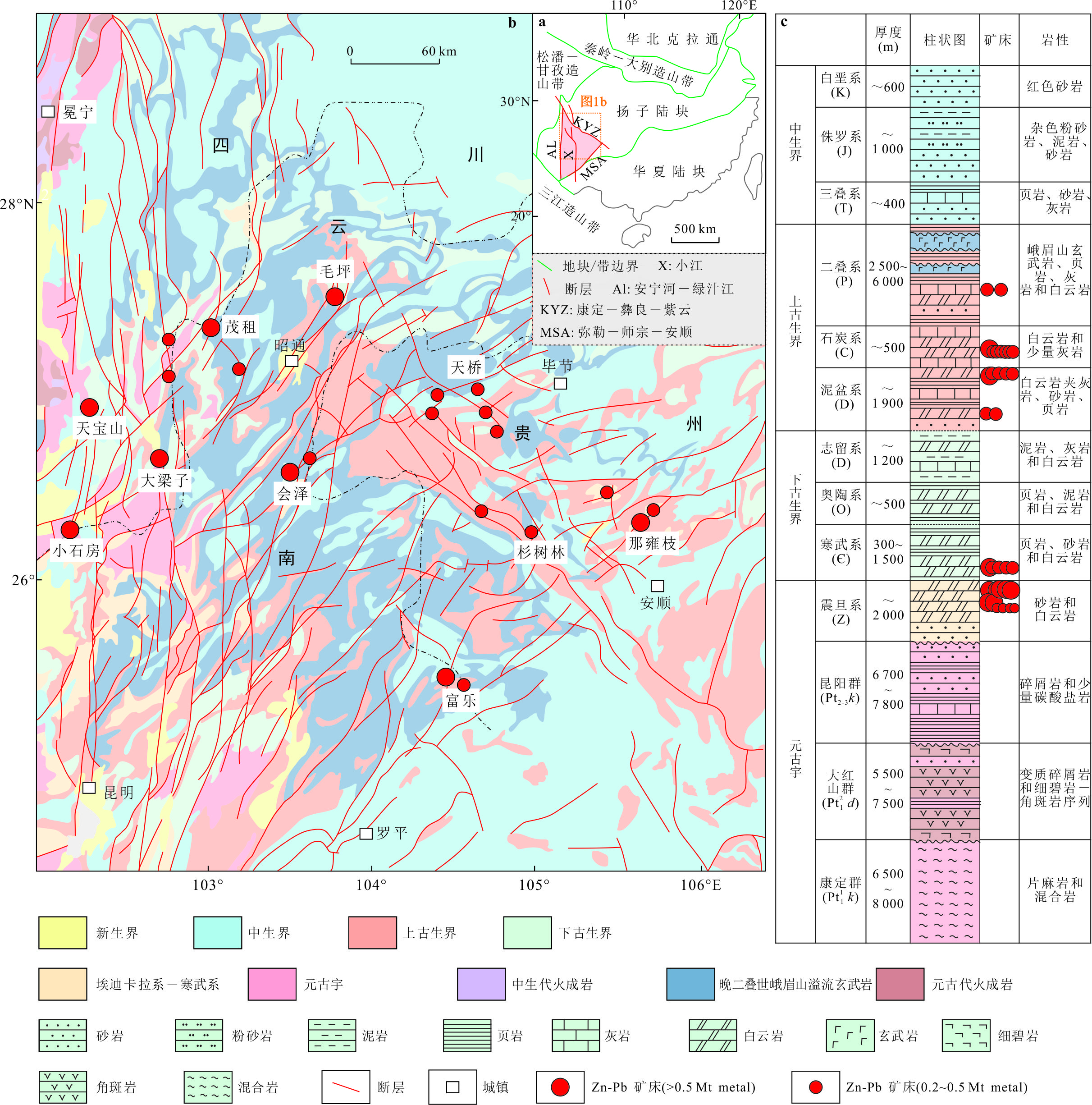
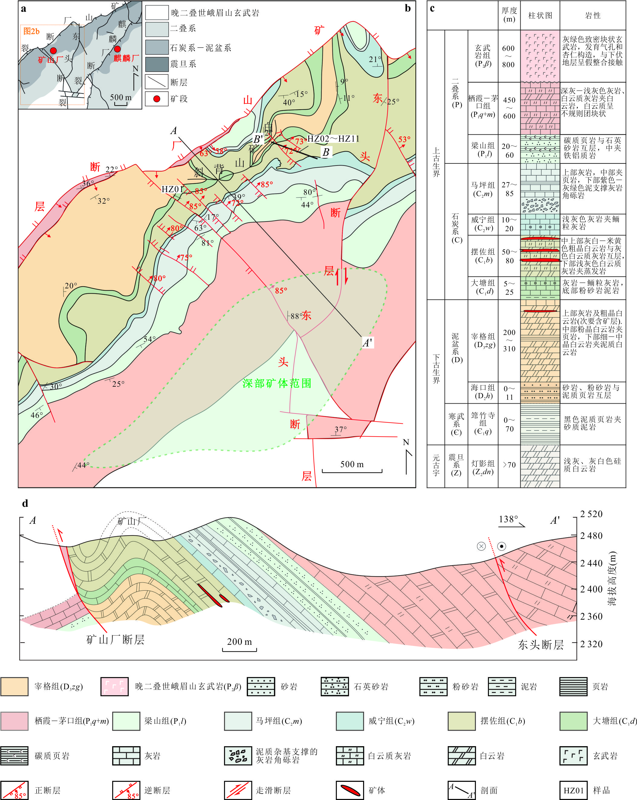
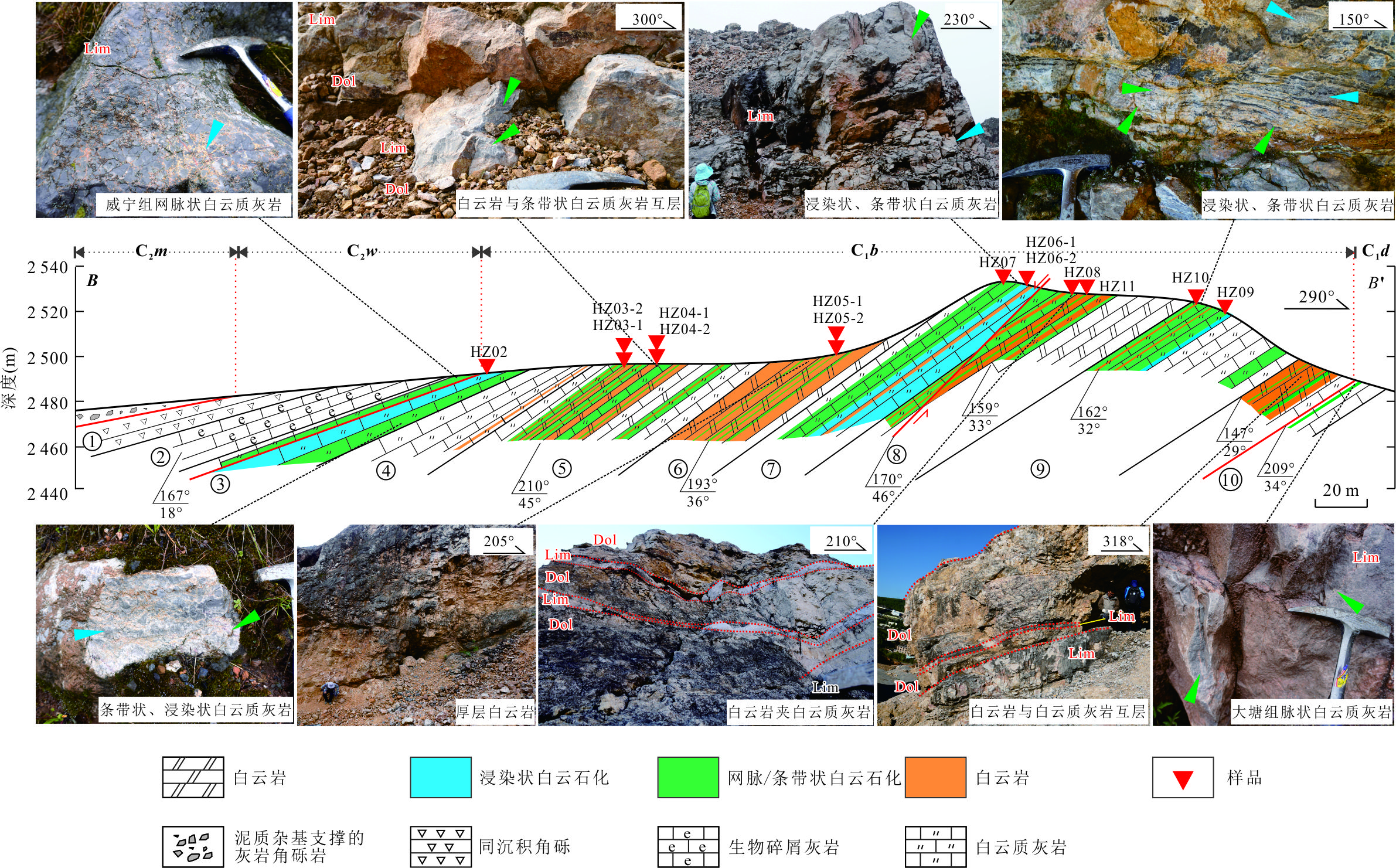
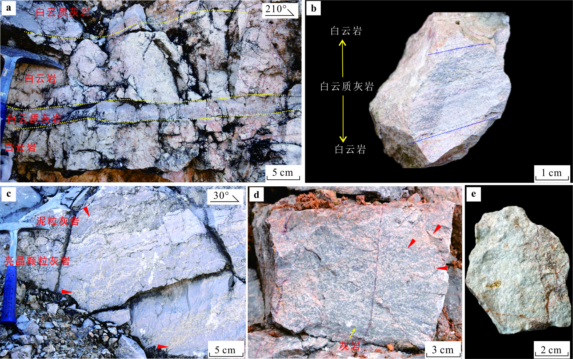
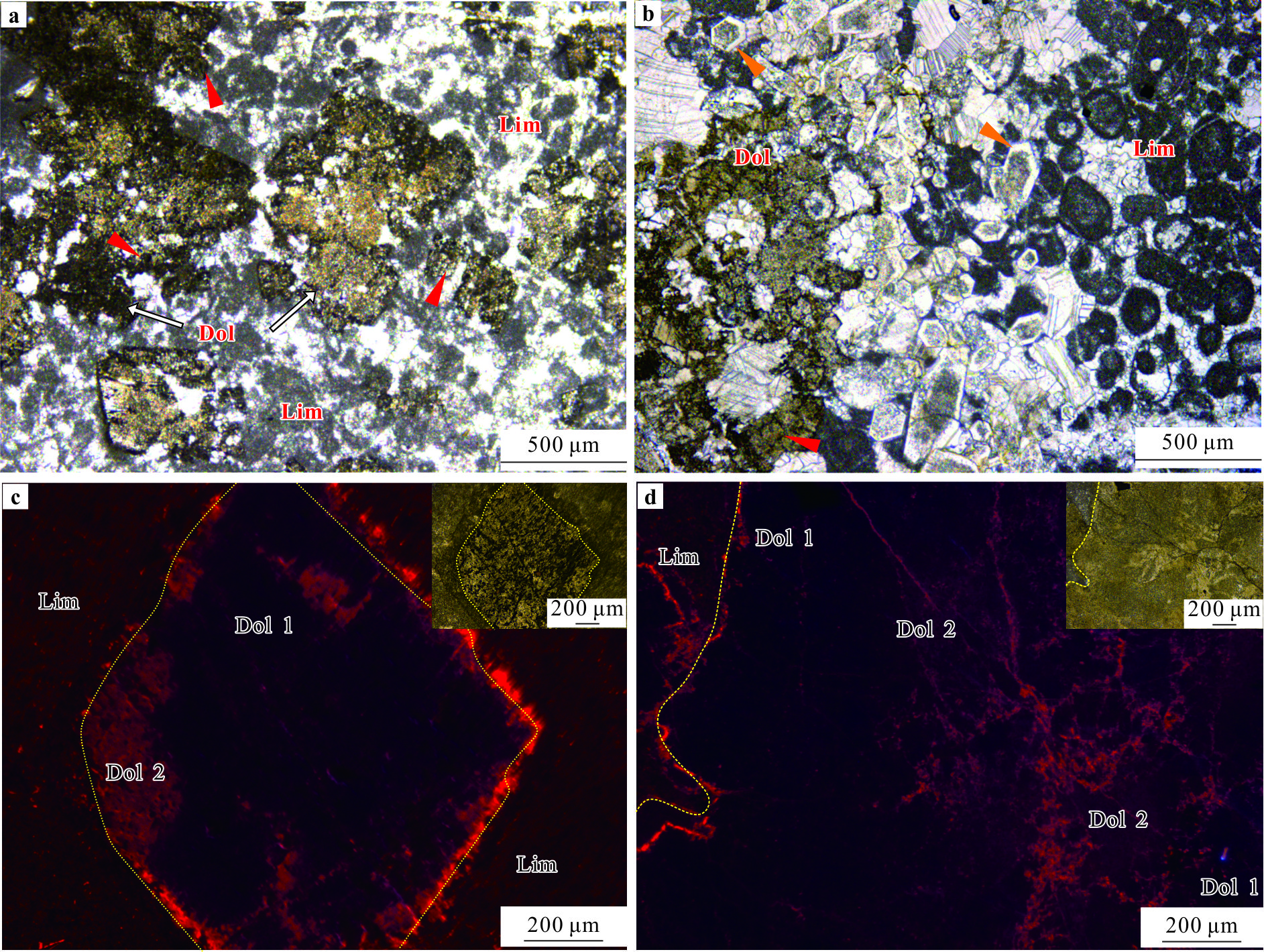
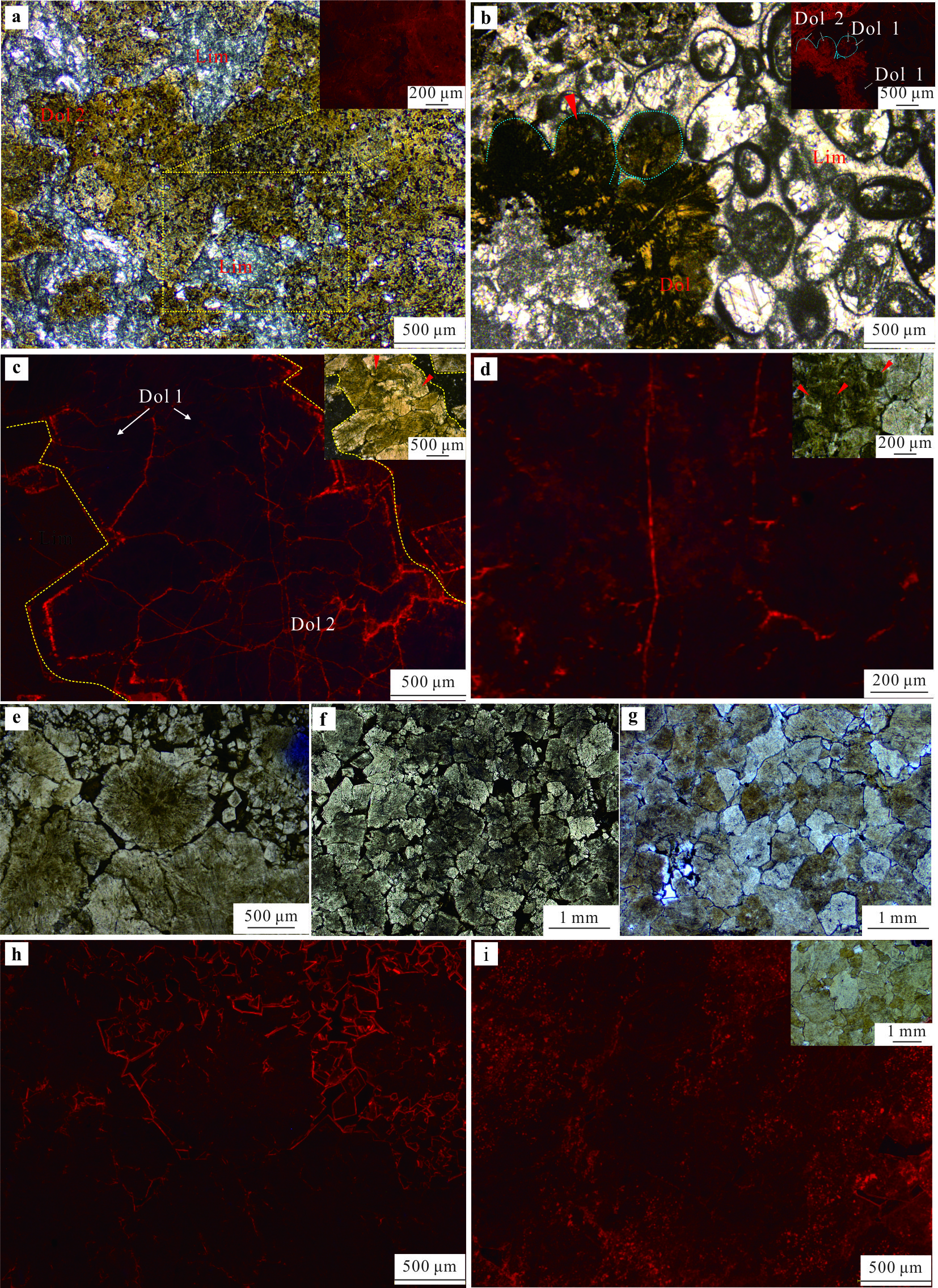
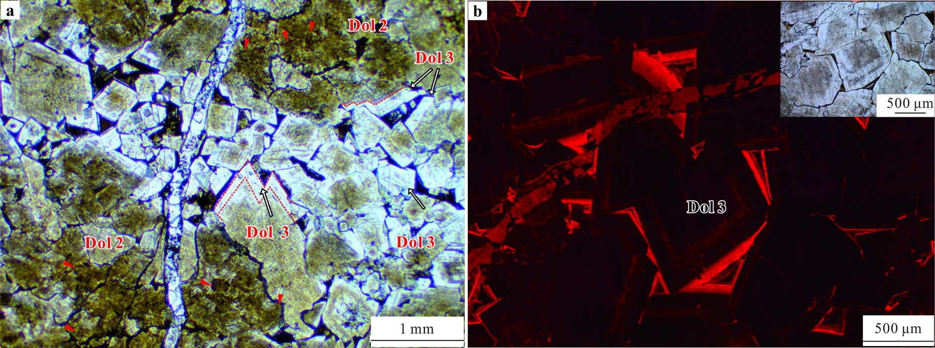
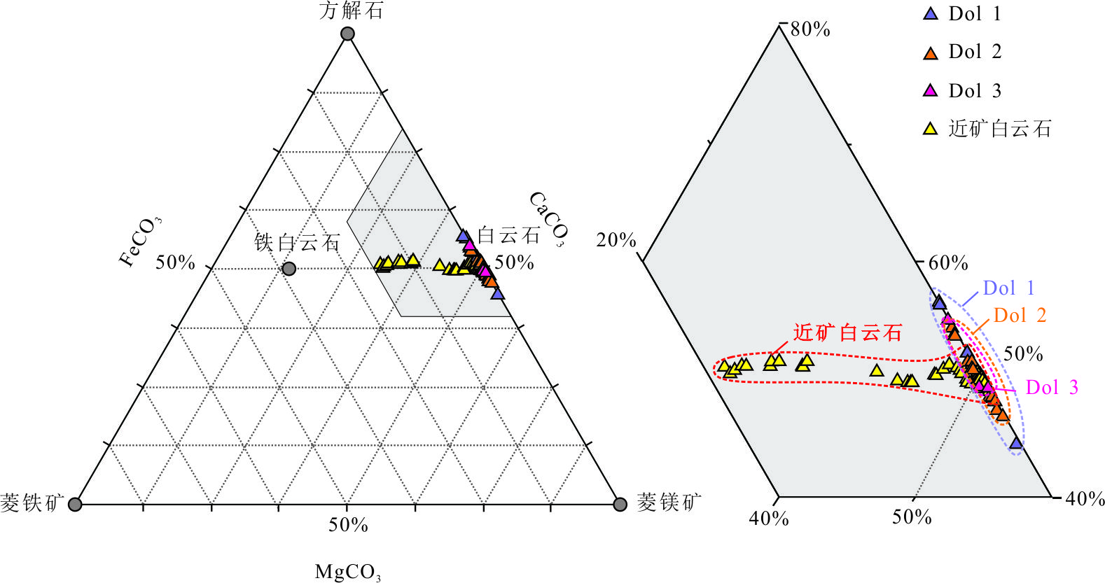
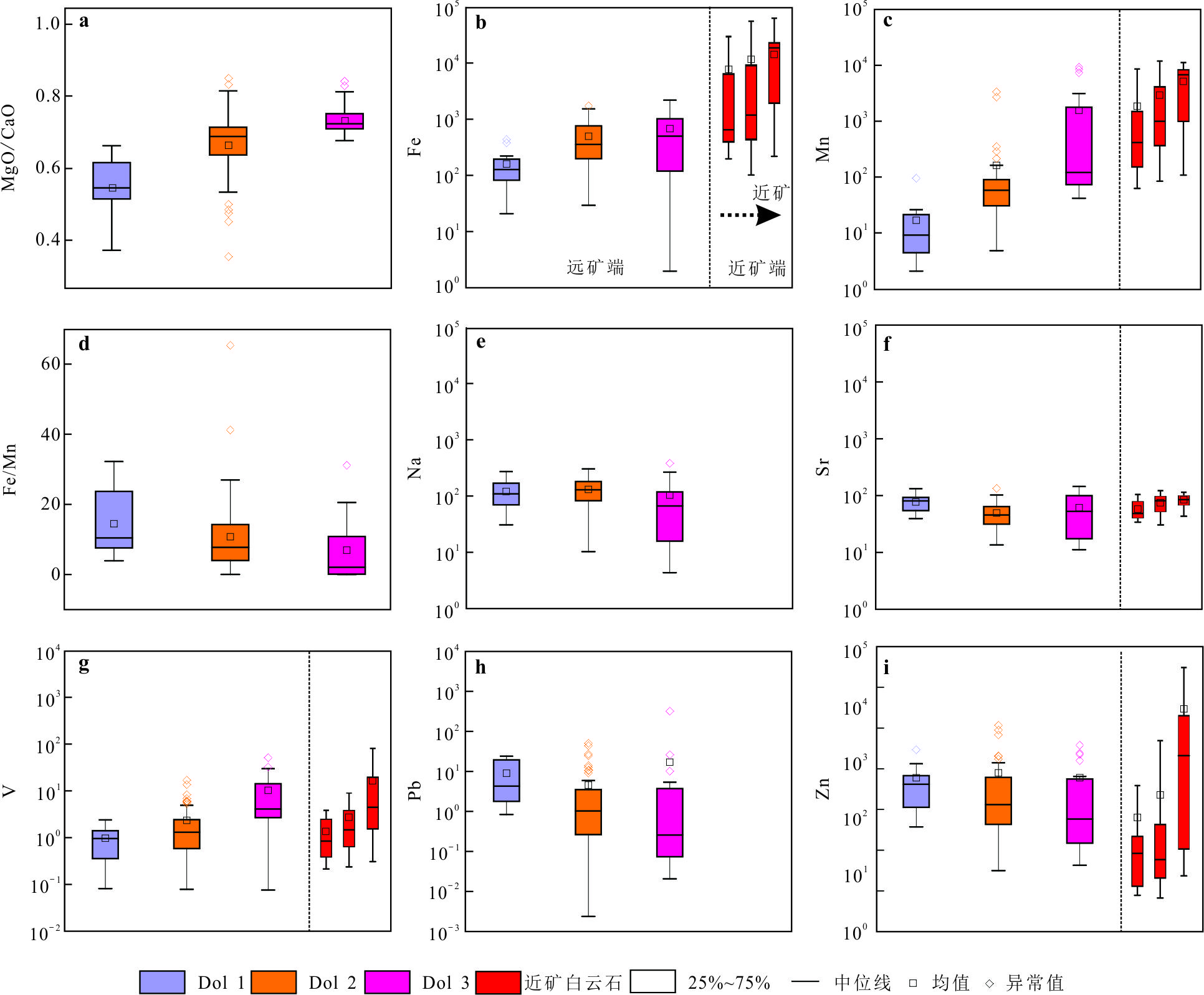
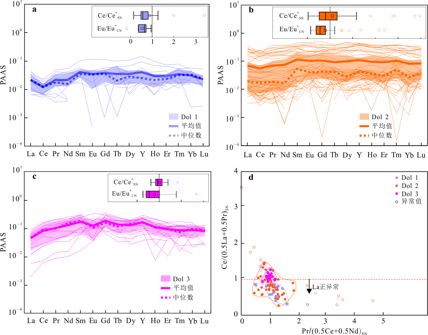
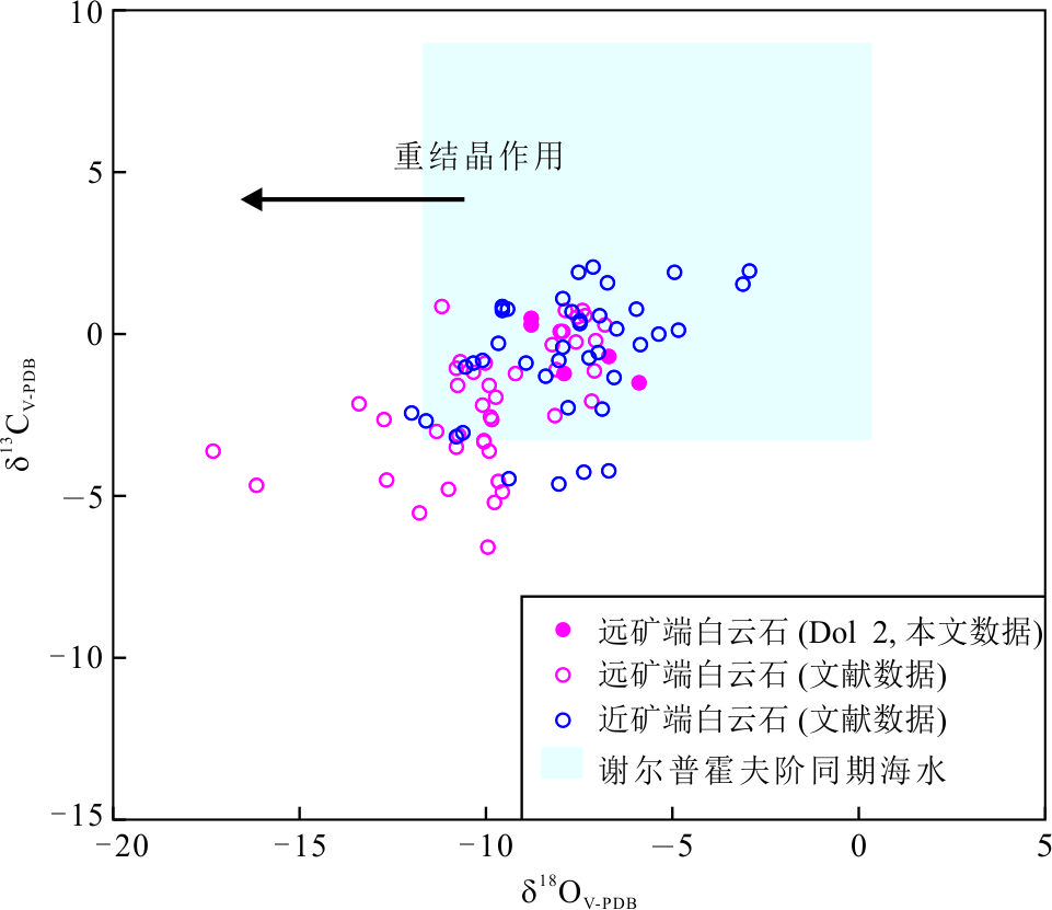
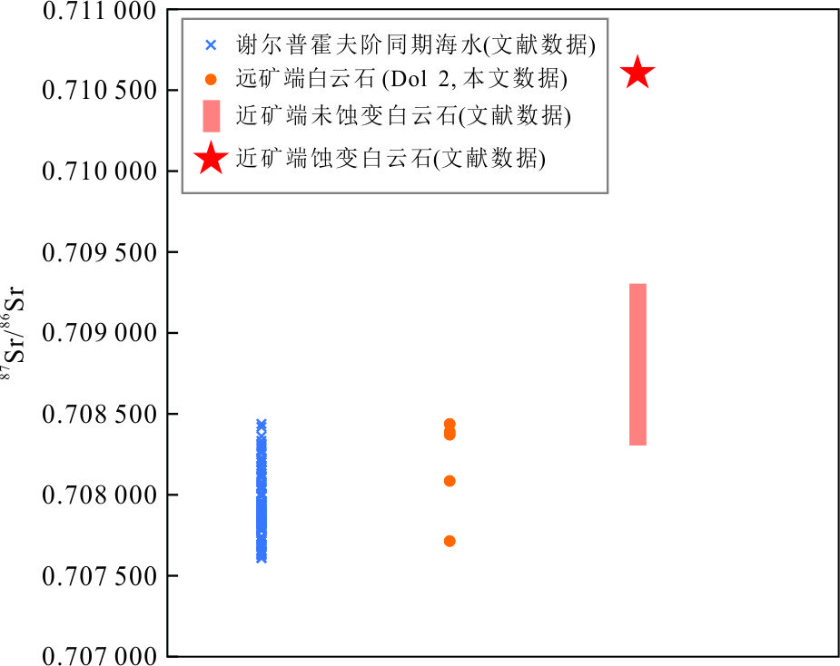
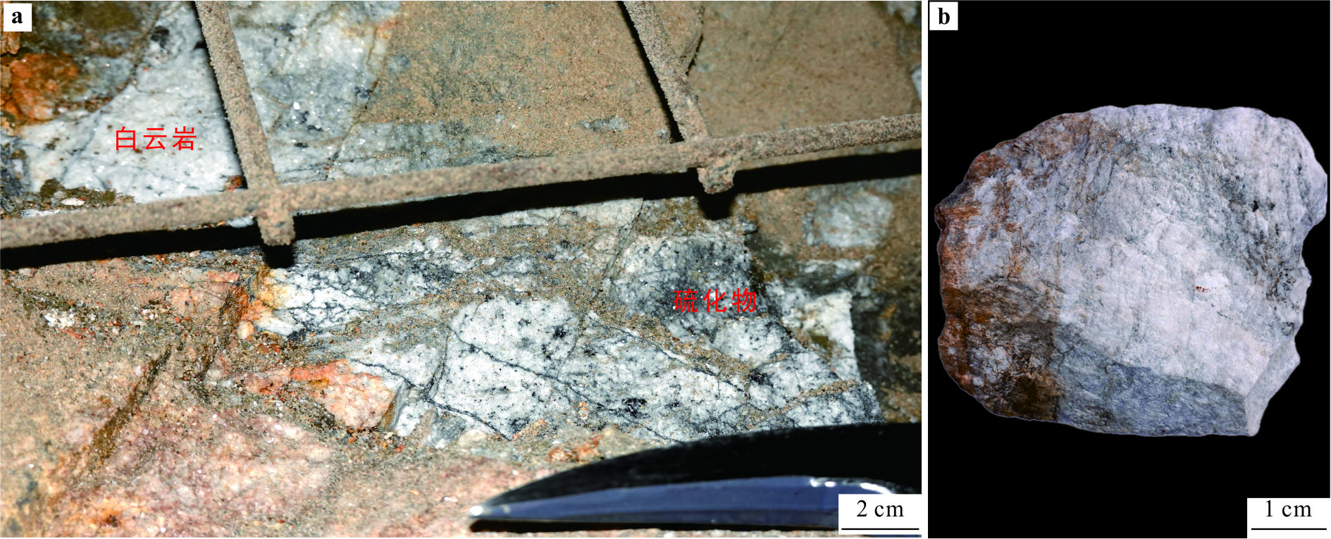
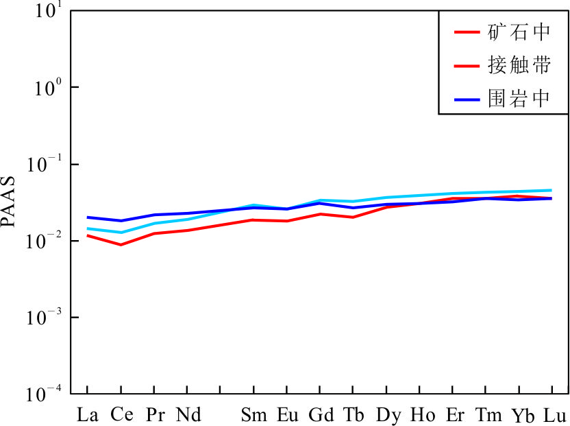
The origin of dolomite in dolostone-hosted Mississippi valley-type (MVT) lead-zinc deposits has long been controversial. The Huize super-large lead-zinc deposit, situated in the Sichuan-Yunnan-Guizhou adjacent region, exemplifies a typical MVT deposit hosted within dolostones and dolomitized limestones, making it an ideal object for addressing the aforementioned issue. This study focuses on disseminated, banded, and blocky distal dolomite from the Lower Carboniferous Baizuo Formation of the Huize orefield. Through comprehensive petrographic analysis and cathodoluminescence (CL) microscopy, coupled with the examination of major elements, LA-ICP-MS in-situ compositional data, and carbon, oxygen, and strontium isotopic analyses, it systematically investigates the genesis of these dolomites. These characteristics indicate that the dolomite in the Baizuo Formation underwent formation through three distinct stages. The first stage—replacement powdered dolomite (Dol 1)—exhibits selective and fabric-retentive replacement, characterized by a blue-purple CL, a MgO/CaO ratio of 0.68, low iron (Fe) and manganese (Mn) contents, weak light rare earth element (LREE) depletion, negative europium (Eu) and cerium (Ce) anomalies, and a positive lanthanum (La) anomaly. The second stage—replacement fine-coarse crystalline dolomite (Dol 2)—shows fabric-retentive replacement and recrystallization, displaying a dark red-orange CL, a MgO/CaO ratio of 0.71, higher Fe and Mn contents compared to the first stage, slight LREE depletion, a negative Eu anomaly, and slightly negative to positive Ce anomalies. C-O and Sr isotopes fall within the range of Early Carboniferous seawater. The third stage—coarse crystalline dolomite cement (Dol 3)—fills cavities in dolostone, exhibiting alternating dark red and bright red CL bands, an average MgO/CaO ratio of 0.68, higher Fe and Mn contents, enriched middle rare earth elements (MREE), negative Eu anomalies, and no Ce anomalies. The results indicate that dolomitizing fluid in the first stage originated from localized oxidizing seawater. In the second stage, the dolomitization fluid comprised oxidizing to weakly oxidizing, saline shallow-burial pore waters. The third stage dolomitizing fluid is suggested to be Mn-rich deep-burial pore waters or residual seawater in a reducing environment. Based on the findings, in this paper it establishes the formation process of widespread dolomitization in the Baizuo Formation of the Huize Pb-Zn orefield. (1) The seepage-reflux dolomitization in near-surface to shallow burial environments lead to the formation of Dol 1 and Dol 2; (2) Recrystallization processes within burial environments alter dolomiteto form coarse crystalline dolostone; (3) During the post-diagenetic deep burial stage, Dol 3 precipitates in the cavities of the coarse crystalline dolostone. Therefore, the dolomite at both the proximal and distal extents exhibit similar characteristics and genetic mechanisms, and the dolomite in proximity to the ore body may have undergone alteration by hydrothermal fluids.
The origin of dolomite in dolostone-hosted Mississippi valley-type (MVT) lead-zinc deposits has long been controversial. The Huize super-large lead-zinc deposit, situated in the Sichuan-Yunnan-Guizhou adjacent region, exemplifies a typical MVT deposit hosted within dolostones and dolomitized limestones, making it an ideal object for addressing the aforementioned issue. This study focuses on disseminated, banded, and blocky distal dolomite from the Lower Carboniferous Baizuo Formation of the Huize orefield. Through comprehensive petrographic analysis and cathodoluminescence (CL) microscopy, coupled with the examination of major elements, LA-ICP-MS in-situ compositional data, and carbon, oxygen, and strontium isotopic analyses, it systematically investigates the genesis of these dolomites. These characteristics indicate that the dolomite in the Baizuo Formation underwent formation through three distinct stages. The first stage—replacement powdered dolomite (Dol 1)—exhibits selective and fabric-retentive replacement, characterized by a blue-purple CL, a MgO/CaO ratio of 0.68, low iron (Fe) and manganese (Mn) contents, weak light rare earth element (LREE) depletion, negative europium (Eu) and cerium (Ce) anomalies, and a positive lanthanum (La) anomaly. The second stage—replacement fine-coarse crystalline dolomite (Dol 2)—shows fabric-retentive replacement and recrystallization, displaying a dark red-orange CL, a MgO/CaO ratio of 0.71, higher Fe and Mn contents compared to the first stage, slight LREE depletion, a negative Eu anomaly, and slightly negative to positive Ce anomalies. C-O and Sr isotopes fall within the range of Early Carboniferous seawater. The third stage—coarse crystalline dolomite cement (Dol 3)—fills cavities in dolostone, exhibiting alternating dark red and bright red CL bands, an average MgO/CaO ratio of 0.68, higher Fe and Mn contents, enriched middle rare earth elements (MREE), negative Eu anomalies, and no Ce anomalies. The results indicate that dolomitizing fluid in the first stage originated from localized oxidizing seawater. In the second stage, the dolomitization fluid comprised oxidizing to weakly oxidizing, saline shallow-burial pore waters. The third stage dolomitizing fluid is suggested to be Mn-rich deep-burial pore waters or residual seawater in a reducing environment. Based on the findings, in this paper it establishes the formation process of widespread dolomitization in the Baizuo Formation of the Huize Pb-Zn orefield. (1) The seepage-reflux dolomitization in near-surface to shallow burial environments lead to the formation of Dol 1 and Dol 2; (2) Recrystallization processes within burial environments alter dolomiteto form coarse crystalline dolostone; (3) During the post-diagenetic deep burial stage, Dol 3 precipitates in the cavities of the coarse crystalline dolostone. Therefore, the dolomite at both the proximal and distal extents exhibit similar characteristics and genetic mechanisms, and the dolomite in proximity to the ore body may have undergone alteration by hydrothermal fluids.

2025, 50(4): 1380-1400.
doi: 10.3799/dqkx.2024.088
Abstract:
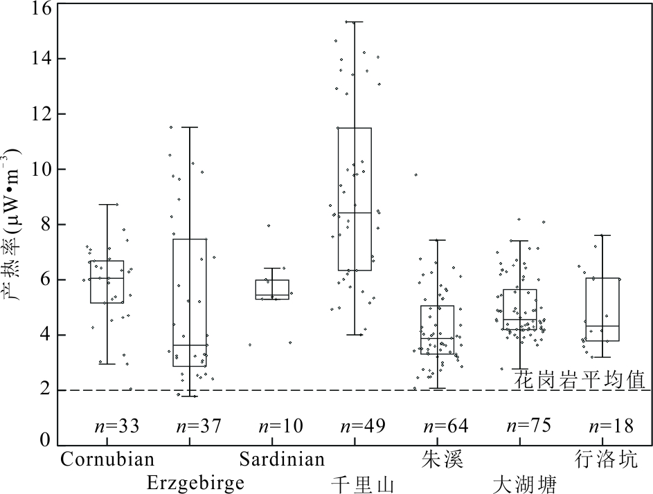
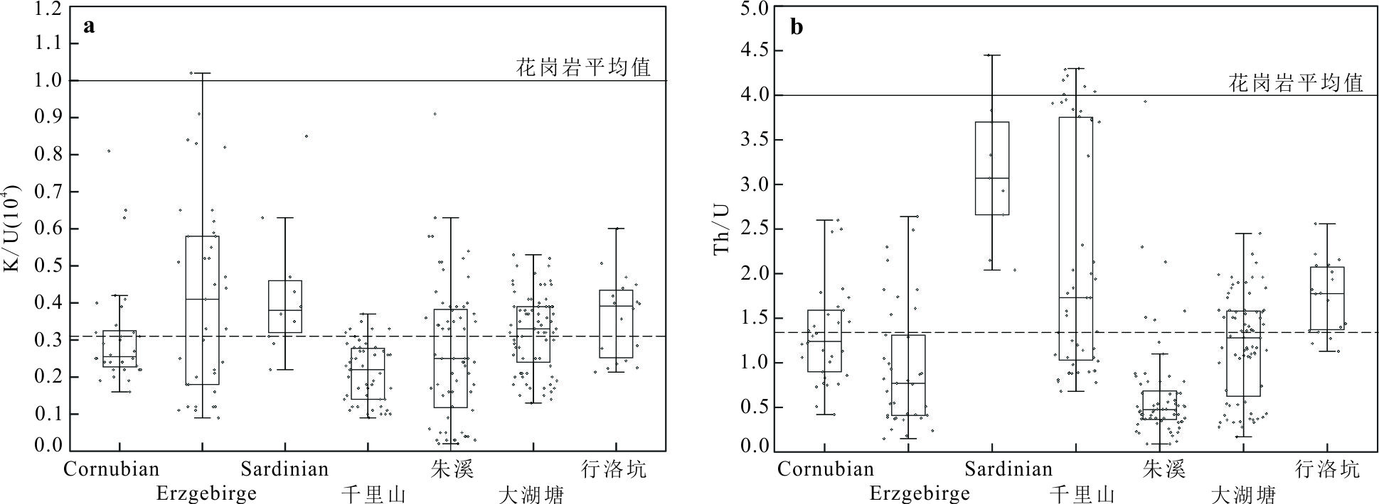
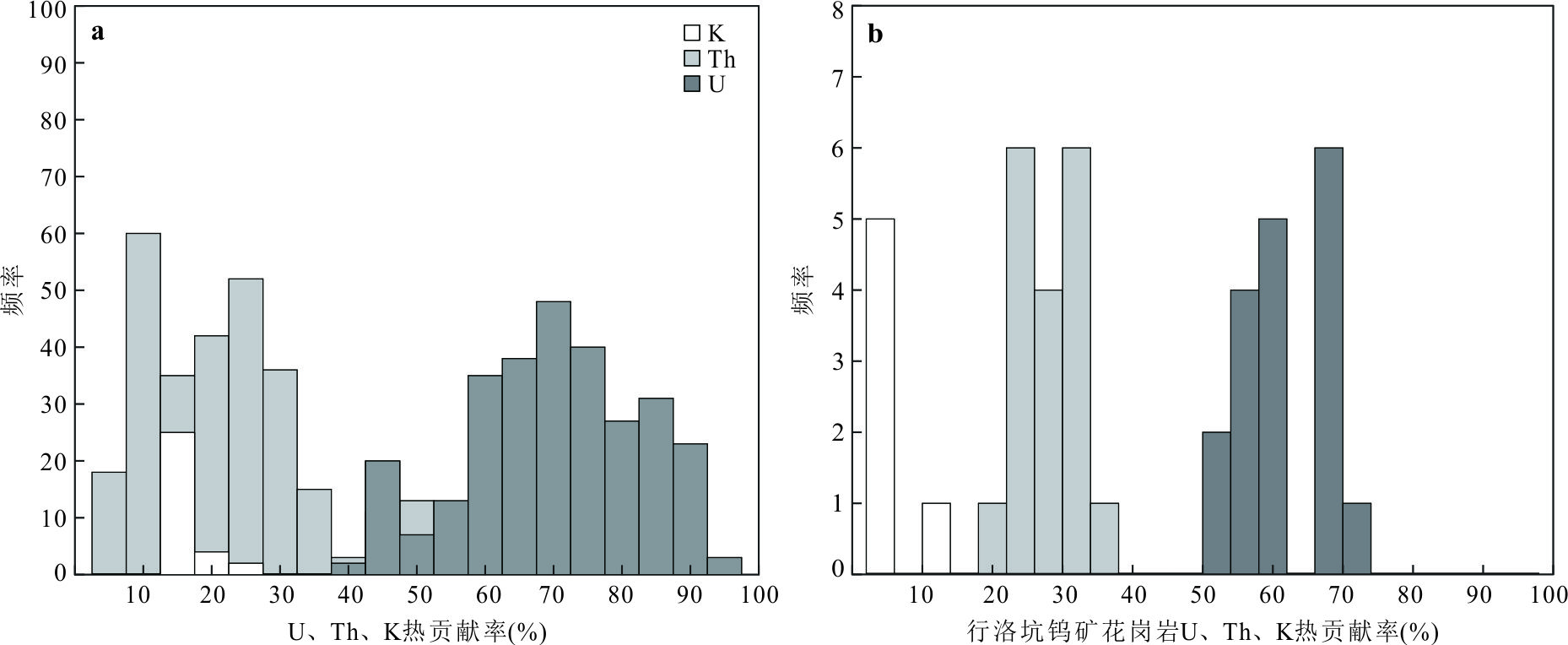
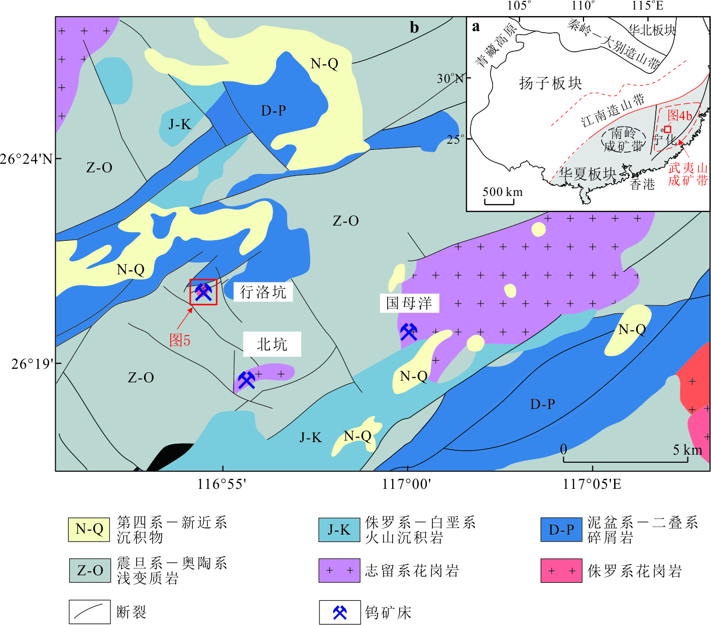
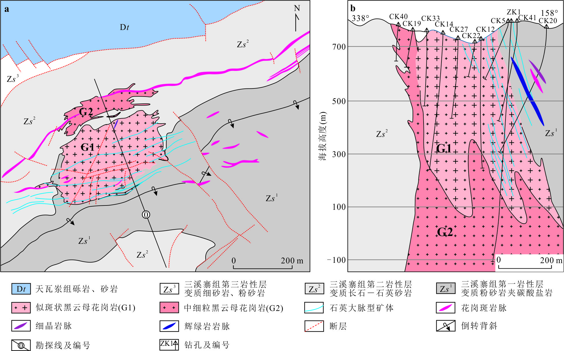
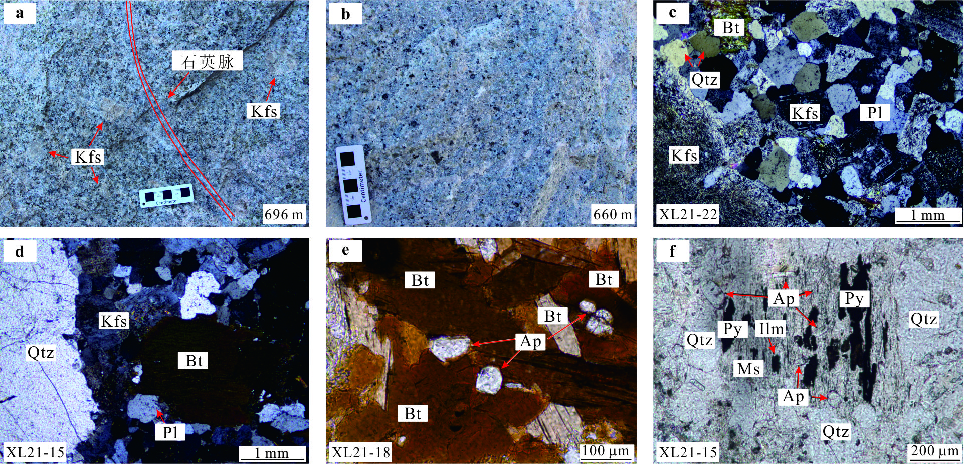
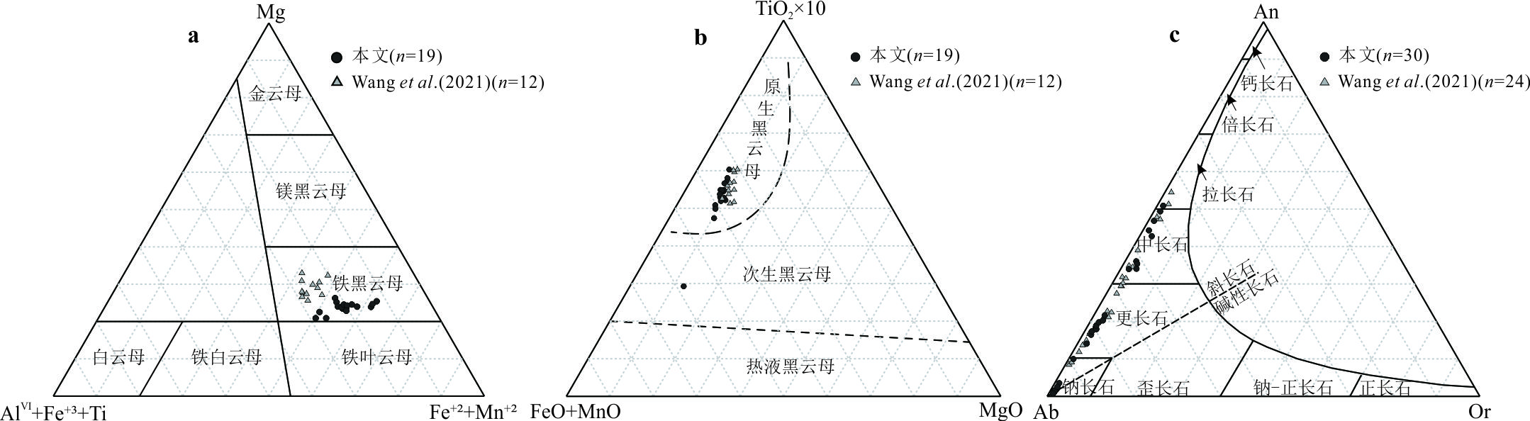
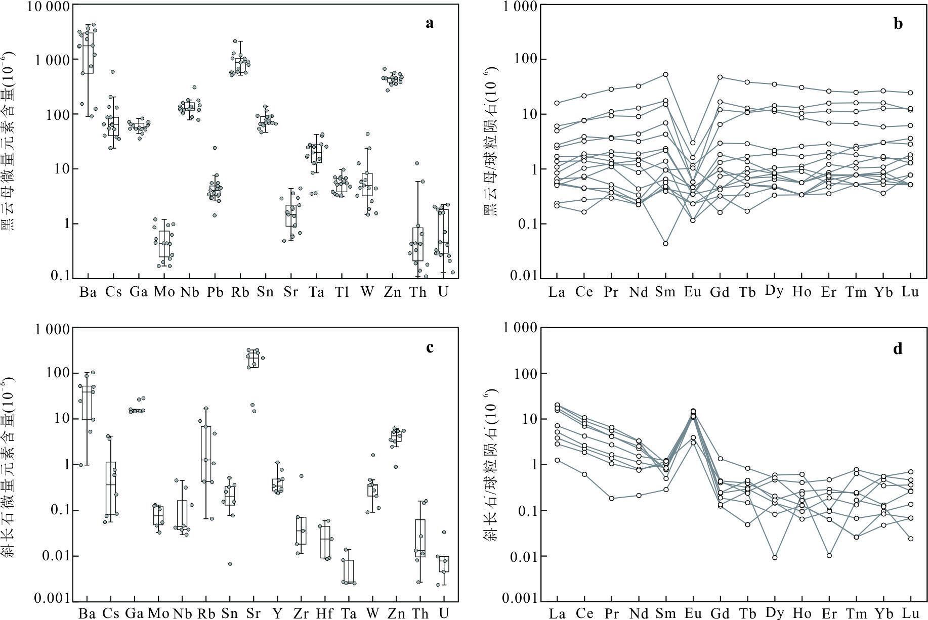
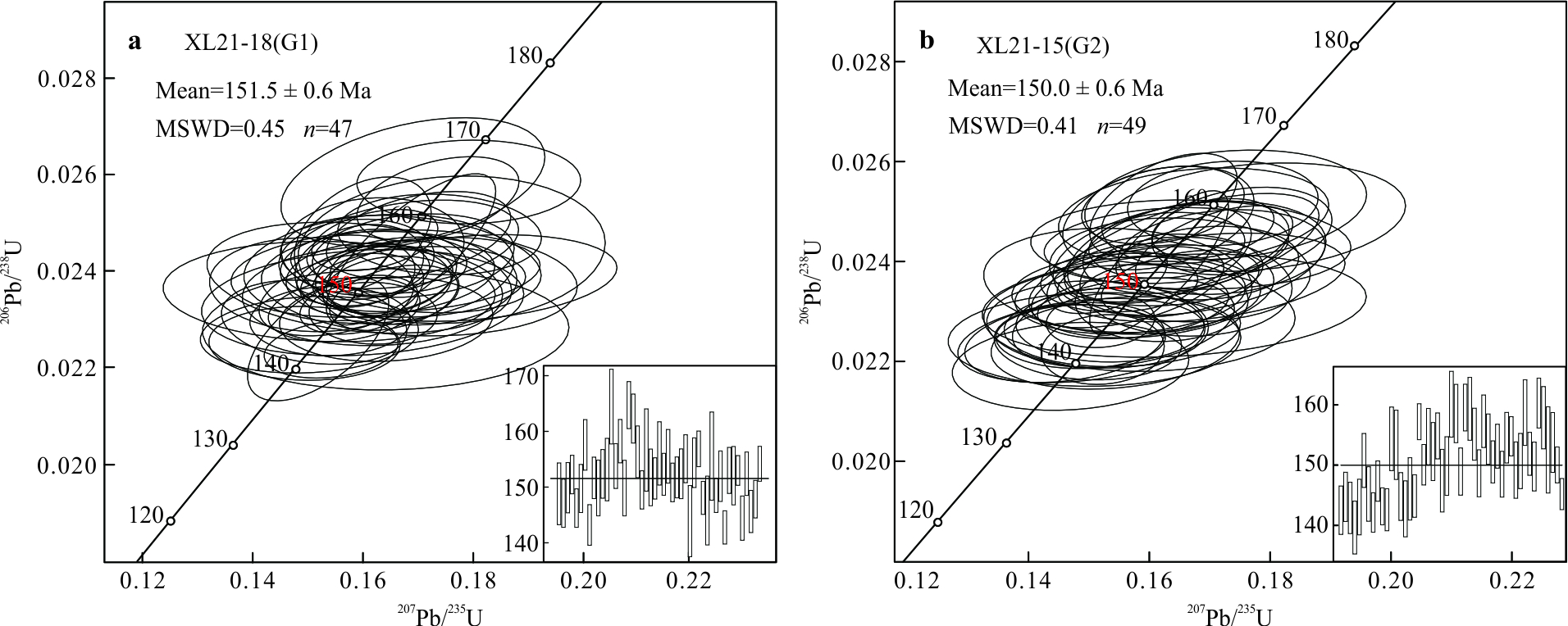
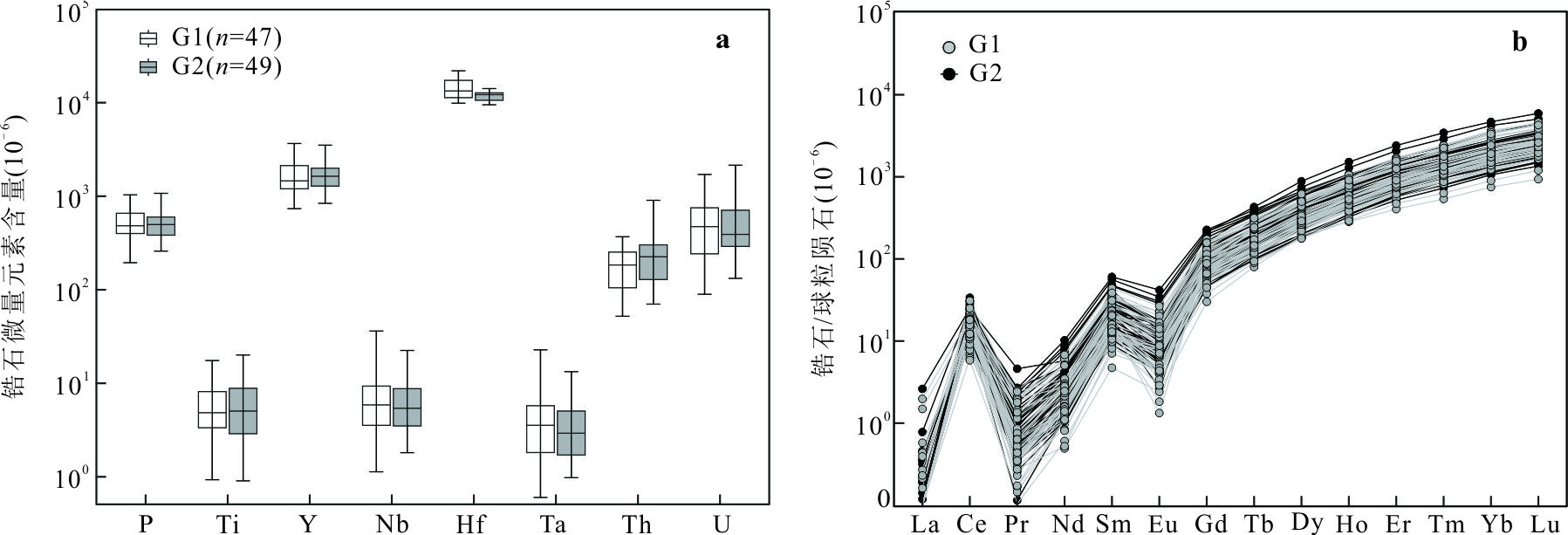
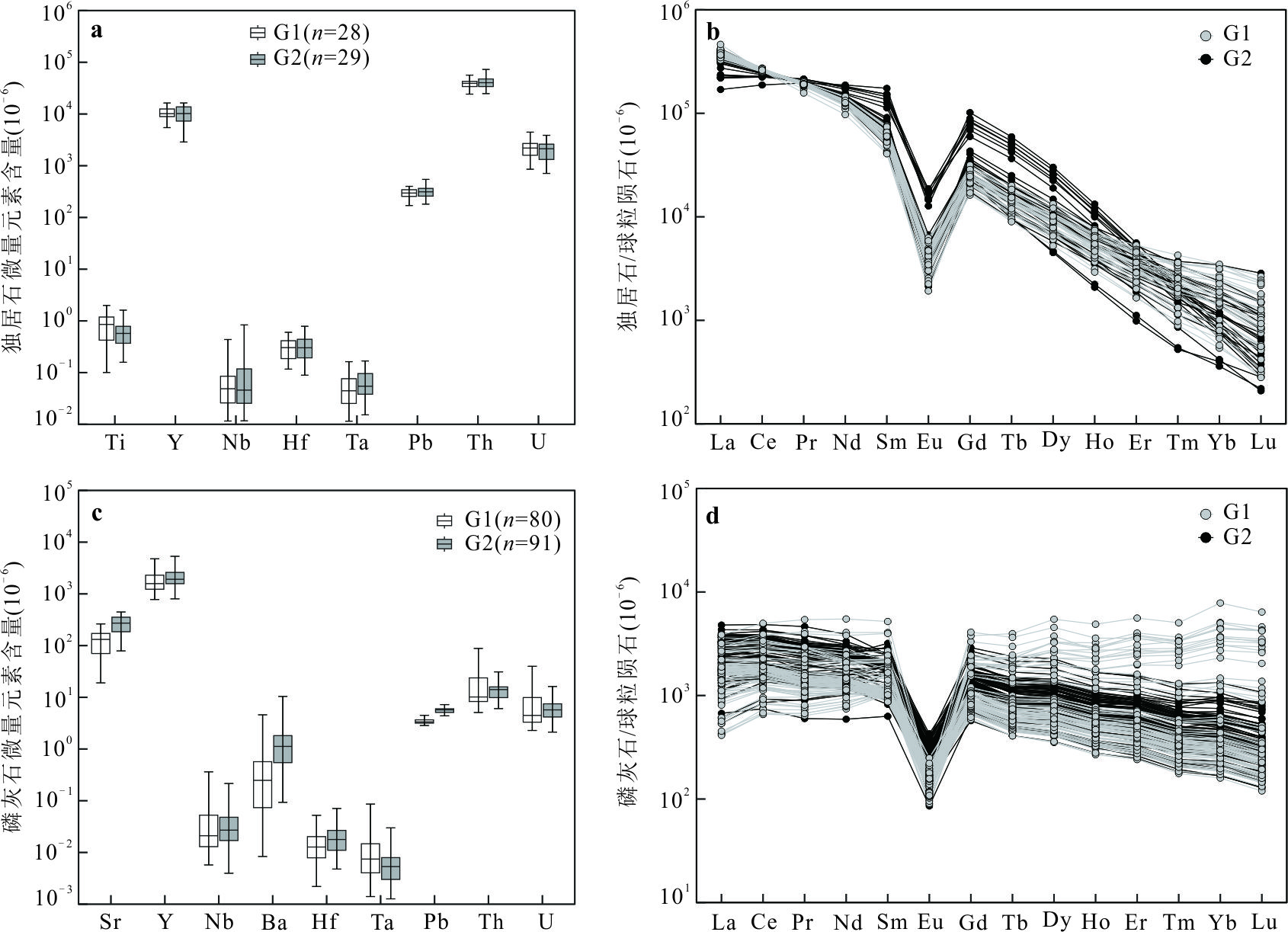
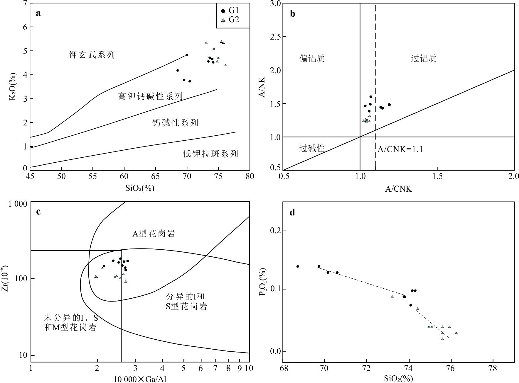
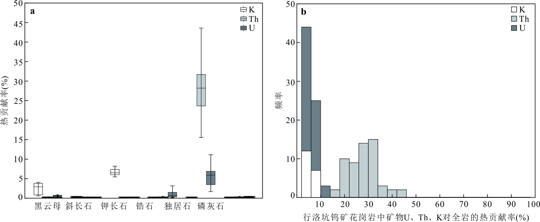
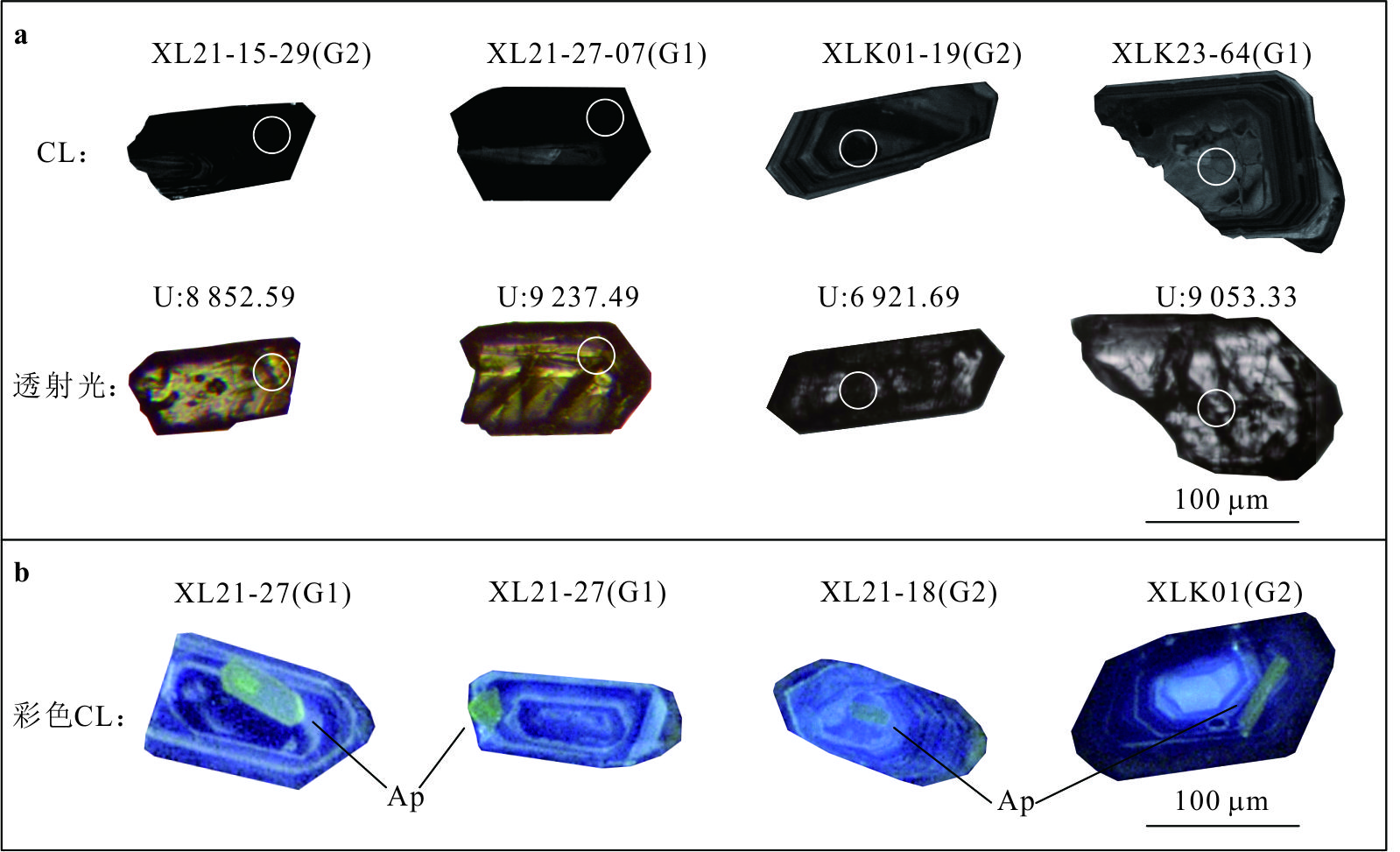
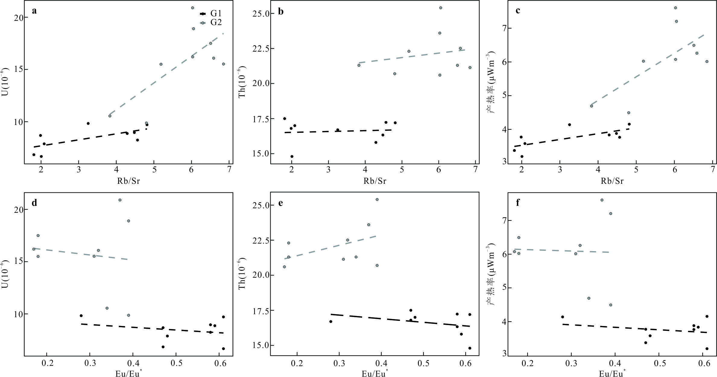
Tungsten deposit is genetically related to highly differentiated granites. The radioactive heat production of those tungsten-associated granites is mostly 5-10 μW•m-3 and can be classified into high heat-producing granites. The radioactive heat mainly comes from U (70%), followed by Th (20%) and K (< 10%). The distribution pattern and genesis of heat-producing elements in tungsten granites are still unclear. The Xingluokeng large-scale tungsten deposit in Fujian Province was chosen as a typical case study. The main occurrence minerals of U, Th, and K were constrained using the principle of mass conservation, the compositional analysis of single minerals (biotite, plagioclase, zircon, monazite, and apatite), and published major and trace element data of the whole rock in the Xingluokeng granites. The zircon U-Pb ages of G1 and G2 are 151.5±0.6 Ma and 150.0±0.6 Ma, respectively. The total heat production rates of G1 and G2 calculated from single minerals are 1.78 μW•m-3 and 2.28 μW•m-3, respectively. Among them, K mainly occurs in K-feldspar and biotite, and the heat contribution rate of K of these two minerals to the whole rock is less than 10%. Th mainly comes from monazite, and the Th heat contribution rate in monazite is 46% at the highest. U mainly comes from zircon and monazite, and the heat contribution rate is less than 15%. The heat production rates of G1 and G2 minerals are 48% and 37% of the whole rock average heat production rates (3.74 μW•m-3 and 6.10 μW•m-3, respectively). This significant difference may be due to a large amount of U existing in a small amount of high-U zircon. Due to the limited statistical sampling of these high-U zircons, the calculated heat production rate from single minerals tends to be underestimated. The enrichment of U and Th in the Xingluokeng granites may be controlled by the protoliths and later crystallization differentiation.The decay heat from radioactive elements in the Xingluokeng granite (especially the late granite) may prolong the time limit of hydrothermal convection and promote the formation of scheelite.
Tungsten deposit is genetically related to highly differentiated granites. The radioactive heat production of those tungsten-associated granites is mostly 5-10 μW•m-3 and can be classified into high heat-producing granites. The radioactive heat mainly comes from U (70%), followed by Th (20%) and K (< 10%). The distribution pattern and genesis of heat-producing elements in tungsten granites are still unclear. The Xingluokeng large-scale tungsten deposit in Fujian Province was chosen as a typical case study. The main occurrence minerals of U, Th, and K were constrained using the principle of mass conservation, the compositional analysis of single minerals (biotite, plagioclase, zircon, monazite, and apatite), and published major and trace element data of the whole rock in the Xingluokeng granites. The zircon U-Pb ages of G1 and G2 are 151.5±0.6 Ma and 150.0±0.6 Ma, respectively. The total heat production rates of G1 and G2 calculated from single minerals are 1.78 μW•m-3 and 2.28 μW•m-3, respectively. Among them, K mainly occurs in K-feldspar and biotite, and the heat contribution rate of K of these two minerals to the whole rock is less than 10%. Th mainly comes from monazite, and the Th heat contribution rate in monazite is 46% at the highest. U mainly comes from zircon and monazite, and the heat contribution rate is less than 15%. The heat production rates of G1 and G2 minerals are 48% and 37% of the whole rock average heat production rates (3.74 μW•m-3 and 6.10 μW•m-3, respectively). This significant difference may be due to a large amount of U existing in a small amount of high-U zircon. Due to the limited statistical sampling of these high-U zircons, the calculated heat production rate from single minerals tends to be underestimated. The enrichment of U and Th in the Xingluokeng granites may be controlled by the protoliths and later crystallization differentiation.The decay heat from radioactive elements in the Xingluokeng granite (especially the late granite) may prolong the time limit of hydrothermal convection and promote the formation of scheelite.
2025, 50(4): 1443-1469.
doi: 10.3799/dqkx.2024.002
Abstract:
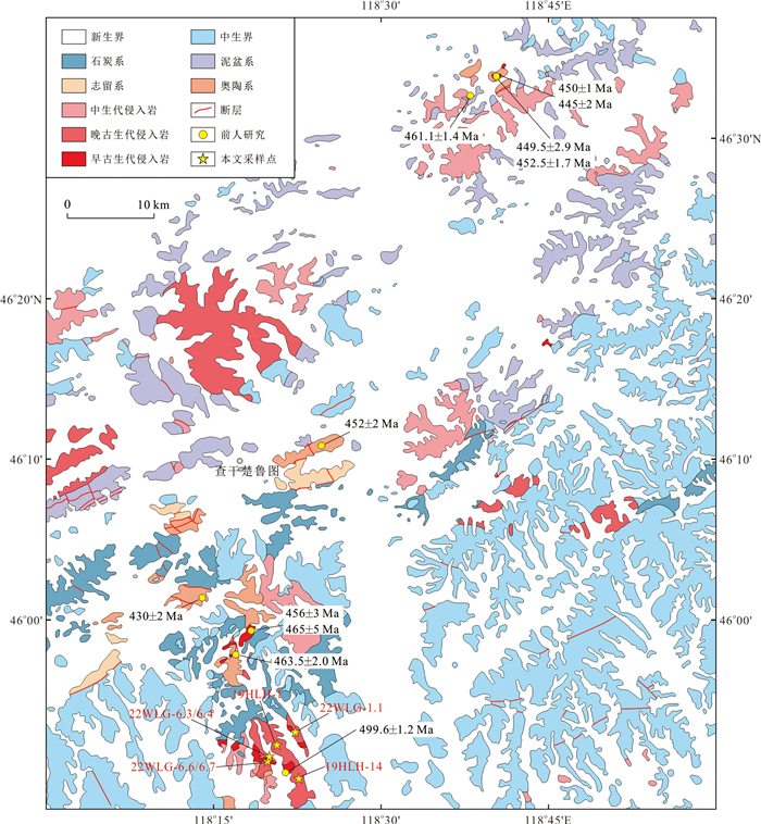
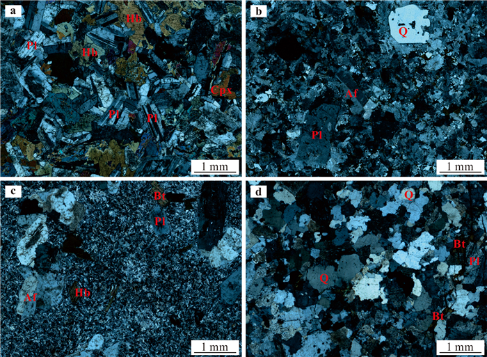
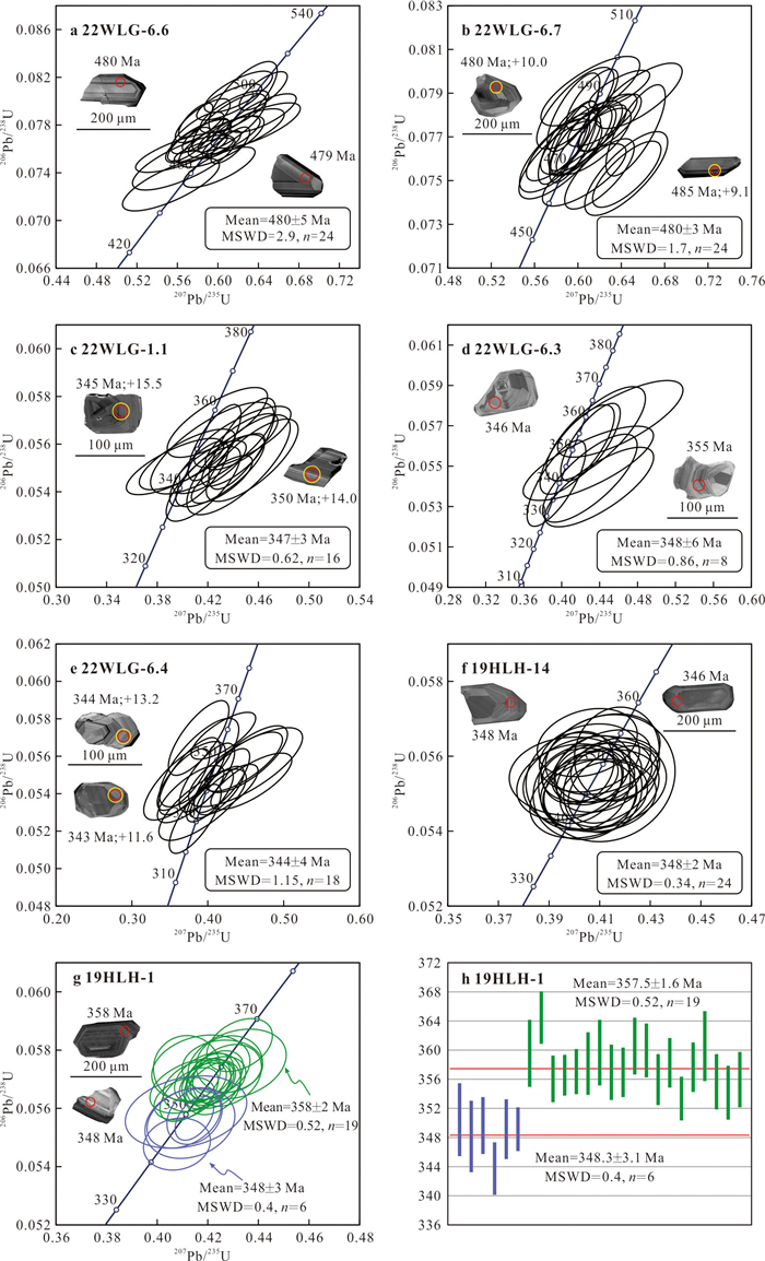
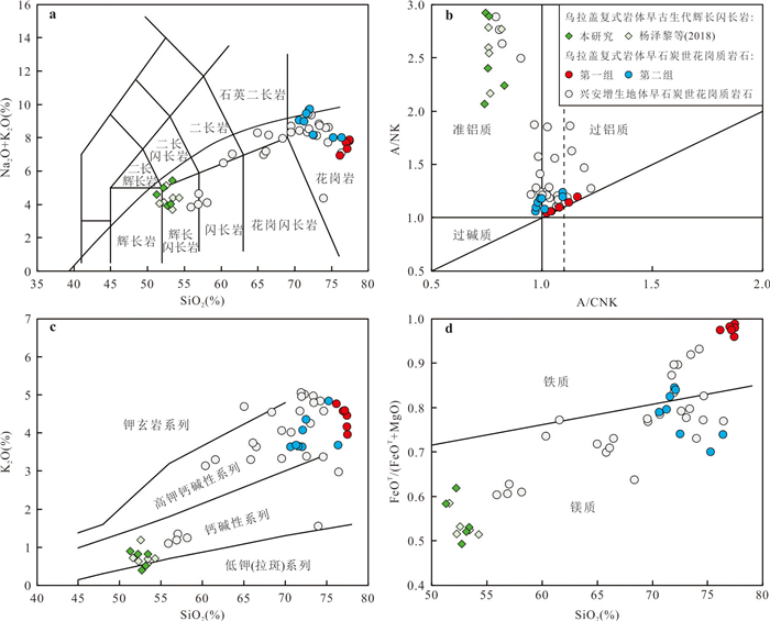
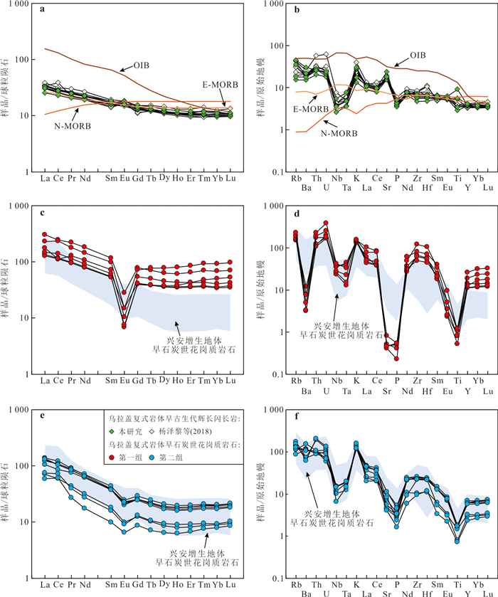
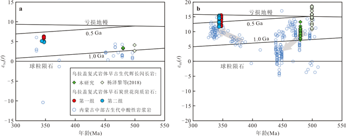
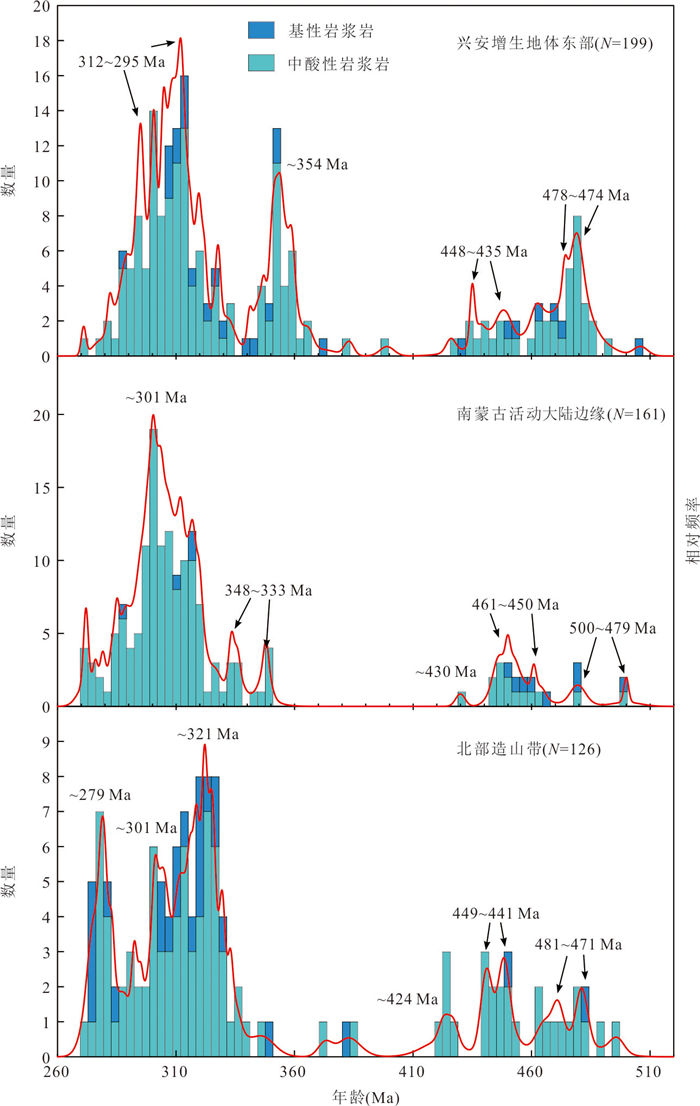
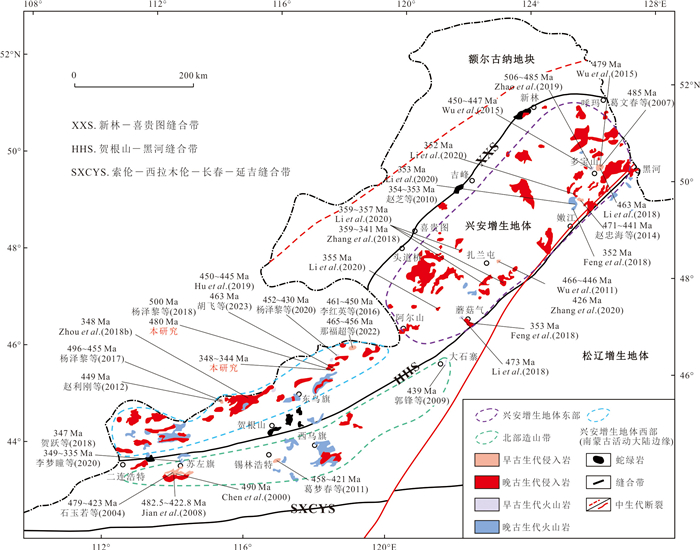
Subduction zone is an important place for the interaction between crust and mantle, and is accompanied by magmatism of different periods and nature.Understanding the characteristics of magmatism in different subduction processes (e.g., advancing subduction and retreating subduction) is of significance for an in-depth understanding of the evolution history of orogenic belts. In this paper, it presents zircon U-Pb ages, whole-rock major- and trace element data, whole-rock Sr-Nd isotope and zircon Hf isotope for Paleozoic intrusions of the Wulagai pluton from East Ujimqin of central Inner Mongolia. Zircon LA-ICP-MS dating for gabbro-diorite yields a weighted mean age of ~480 Ma, suggesting the crystallization age is Early Ordovician; the age of granitoids is 348-344 Ma, representing the products of magmatic activities during Early Carboniferous. Early Ordovician gabbro-diorites(SiO2=51.27%-53.39%) are relatively enriched in light rare earth elements and large ion lithophile elements (e.g., Rb, Th and U), and depleted in high field strength elements (e.g., Nb and Ta), with positive whole-rock εNd(t) values (+3.3 to +3.5) and zircon εHf(t) values (+7.3 to +13.3). The gabbro-diorites were originated from partial melting of a depleted lithospheric mantle that was metasomatized by slab-derived fluids. The Early Carboniferous granitoids can be divided into two groups according to their geochemical compositions.The first group is mainly syenogranite with high SiO2 content (76.19%-77.52%), high total rare earths content, strong Eu negative anomalies, high 10 000 Ga/Al values (3.90-5.95) and zircon saturation temperature (average 965 ℃), displaying typical A-type granite affinity.The second group is mainly granite porphyry and biotite monzogranite with SiO2 content (70.67%-76.42%) lower than the first group.They showing metaluminous to weakly peraluminous characteristics, combined with negative correlation between SiO2 and P2O5, and hornblende can be observed, displaying Ⅰ-type granite affinity.In terms of Nd-Hf isotopic compositions, these two groups of Early Carboniferous granitoids have similar isotopic compositions (first group: εNd(t) = +5.8 to +6.3, εHf(t) = +11.8 to +15.5;second group: εNd(t) = +4.9 to +5.1, εHf(t) = +11.6 to +15.4), indicating that they have similar magmatic source and both derived from partial melting of the juvenile crust, but underwent different evolution processes.Combined with regional magmatism, it proposes an advancing subduction of Paleo-Asian Ocean plate occurred during Early Paleozoic in central Inner Mongolia.Paleo-Asian Ocean plate subducted beneath the South Mongolian microcontinent before Late Cambrian and lead to the formation of gabbro-diorites reported in this study. The advancing subduction caused a series of arc accreted to the southern margin of the South Mongolian microcontinent.Then an arc-continent collision occurred during Late Silurian.The Early Carboniferous A-type and Ⅰ-type granitoids were formed in a back-arc extensional environment which was resulted from the roll back of Paleo-Asian Ocean plate during Late Devonian to Early Carboniferous.
Subduction zone is an important place for the interaction between crust and mantle, and is accompanied by magmatism of different periods and nature.Understanding the characteristics of magmatism in different subduction processes (e.g., advancing subduction and retreating subduction) is of significance for an in-depth understanding of the evolution history of orogenic belts. In this paper, it presents zircon U-Pb ages, whole-rock major- and trace element data, whole-rock Sr-Nd isotope and zircon Hf isotope for Paleozoic intrusions of the Wulagai pluton from East Ujimqin of central Inner Mongolia. Zircon LA-ICP-MS dating for gabbro-diorite yields a weighted mean age of ~480 Ma, suggesting the crystallization age is Early Ordovician; the age of granitoids is 348-344 Ma, representing the products of magmatic activities during Early Carboniferous. Early Ordovician gabbro-diorites(SiO2=51.27%-53.39%) are relatively enriched in light rare earth elements and large ion lithophile elements (e.g., Rb, Th and U), and depleted in high field strength elements (e.g., Nb and Ta), with positive whole-rock εNd(t) values (+3.3 to +3.5) and zircon εHf(t) values (+7.3 to +13.3). The gabbro-diorites were originated from partial melting of a depleted lithospheric mantle that was metasomatized by slab-derived fluids. The Early Carboniferous granitoids can be divided into two groups according to their geochemical compositions.The first group is mainly syenogranite with high SiO2 content (76.19%-77.52%), high total rare earths content, strong Eu negative anomalies, high 10 000 Ga/Al values (3.90-5.95) and zircon saturation temperature (average 965 ℃), displaying typical A-type granite affinity.The second group is mainly granite porphyry and biotite monzogranite with SiO2 content (70.67%-76.42%) lower than the first group.They showing metaluminous to weakly peraluminous characteristics, combined with negative correlation between SiO2 and P2O5, and hornblende can be observed, displaying Ⅰ-type granite affinity.In terms of Nd-Hf isotopic compositions, these two groups of Early Carboniferous granitoids have similar isotopic compositions (first group: εNd(t) = +5.8 to +6.3, εHf(t) = +11.8 to +15.5;second group: εNd(t) = +4.9 to +5.1, εHf(t) = +11.6 to +15.4), indicating that they have similar magmatic source and both derived from partial melting of the juvenile crust, but underwent different evolution processes.Combined with regional magmatism, it proposes an advancing subduction of Paleo-Asian Ocean plate occurred during Early Paleozoic in central Inner Mongolia.Paleo-Asian Ocean plate subducted beneath the South Mongolian microcontinent before Late Cambrian and lead to the formation of gabbro-diorites reported in this study. The advancing subduction caused a series of arc accreted to the southern margin of the South Mongolian microcontinent.Then an arc-continent collision occurred during Late Silurian.The Early Carboniferous A-type and Ⅰ-type granitoids were formed in a back-arc extensional environment which was resulted from the roll back of Paleo-Asian Ocean plate during Late Devonian to Early Carboniferous.
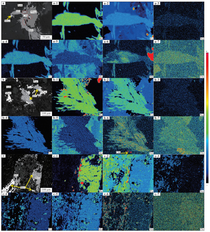
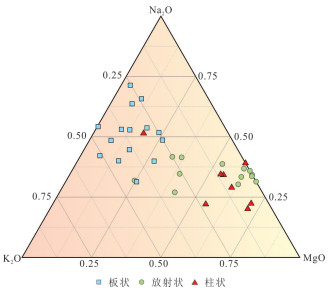
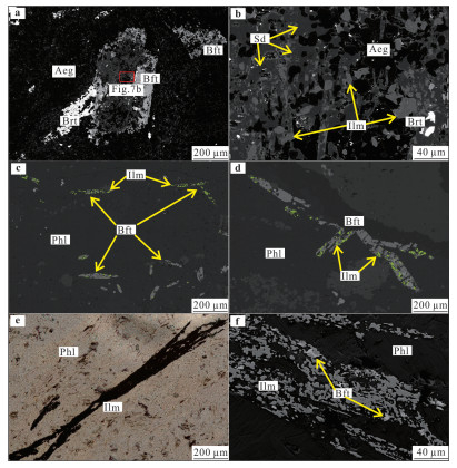
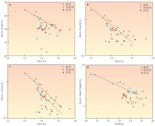
2025, 50(4): 1401-1416.
doi: 10.3799/dqkx.2024.099
Abstract:
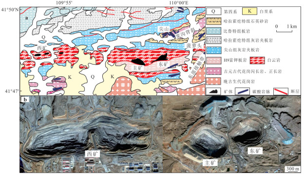
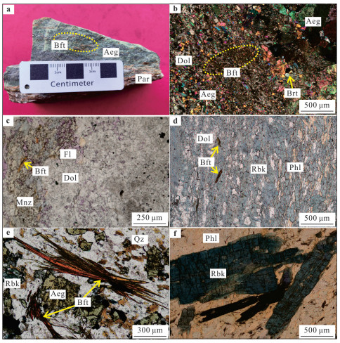
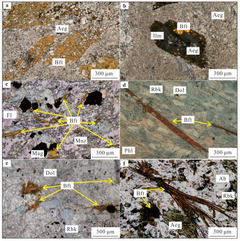
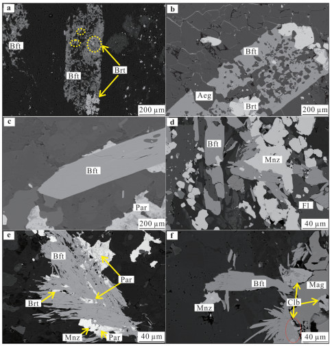
Bafertisite, the first new mineral found in the Bayan Obo deposit, is relatively weakly studied in terms of its morphological features, symbiotic assemblages, and mineralogical genesis. Based on some coarse-grained bafertisite crystals with complete crystal form found in recent years, a detailed mineralogical and mineral chemical study was carried out using polarized reflectance microscope, field emission scanning electron microscope, field emission electron microprobe and other analytical test instruments. The results show that: the color of bafertisite is brownish red to yellowish red, and the grain size is around 0.3-1.0 mm, which is in tabular, radial and columnar forms in aegirine type ore, riebeckite-mica type ore, dolomite type ore, and H9 slate, and the main co-occurring minerals are aegirine and riebeckite, meanwhile, by the influence of late hydrothermal fluids, the mineral crystals underwent different degrees of alteration and accounted for, and the ilmenite, siderite, and barite and other minerals. Due to the alkaline hydrothermal fluid Nb5+ and Ti4+, Fe3+, etc. occurred to varying degrees of homogeneous substitution of analogs, bafertisite crystals contain a certain amount of Nb2O5, and radial bafertisite has the highest content of niobium, 1.72%, in addition to baotite, niobobaotite, bafertisite is another typical niobium-containing Ba, Ti, Fe silicate minerals. In summary, it is initially believed that the crystalline distribution of bafertisite is mainly controlled by the action of sodic fluids in the ore area, and that tabular bafertisite, radial and columnar bafertisite represent the early and late fentization process in the orebody, respectively. In addition, Ti-bearing minerals in the orebody are important niobium minerals and niobium-bearing minerals that deserve attention in subsequent studies.
Bafertisite, the first new mineral found in the Bayan Obo deposit, is relatively weakly studied in terms of its morphological features, symbiotic assemblages, and mineralogical genesis. Based on some coarse-grained bafertisite crystals with complete crystal form found in recent years, a detailed mineralogical and mineral chemical study was carried out using polarized reflectance microscope, field emission scanning electron microscope, field emission electron microprobe and other analytical test instruments. The results show that: the color of bafertisite is brownish red to yellowish red, and the grain size is around 0.3-1.0 mm, which is in tabular, radial and columnar forms in aegirine type ore, riebeckite-mica type ore, dolomite type ore, and H9 slate, and the main co-occurring minerals are aegirine and riebeckite, meanwhile, by the influence of late hydrothermal fluids, the mineral crystals underwent different degrees of alteration and accounted for, and the ilmenite, siderite, and barite and other minerals. Due to the alkaline hydrothermal fluid Nb5+ and Ti4+, Fe3+, etc. occurred to varying degrees of homogeneous substitution of analogs, bafertisite crystals contain a certain amount of Nb2O5, and radial bafertisite has the highest content of niobium, 1.72%, in addition to baotite, niobobaotite, bafertisite is another typical niobium-containing Ba, Ti, Fe silicate minerals. In summary, it is initially believed that the crystalline distribution of bafertisite is mainly controlled by the action of sodic fluids in the ore area, and that tabular bafertisite, radial and columnar bafertisite represent the early and late fentization process in the orebody, respectively. In addition, Ti-bearing minerals in the orebody are important niobium minerals and niobium-bearing minerals that deserve attention in subsequent studies.
2025, 50(4): 1417-1442.
doi: 10.3799/dqkx.2024.025
Abstract:
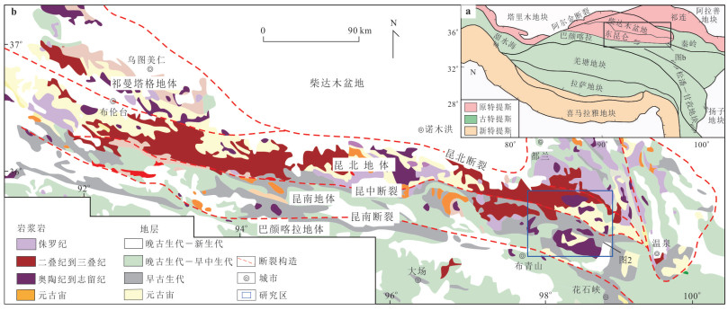
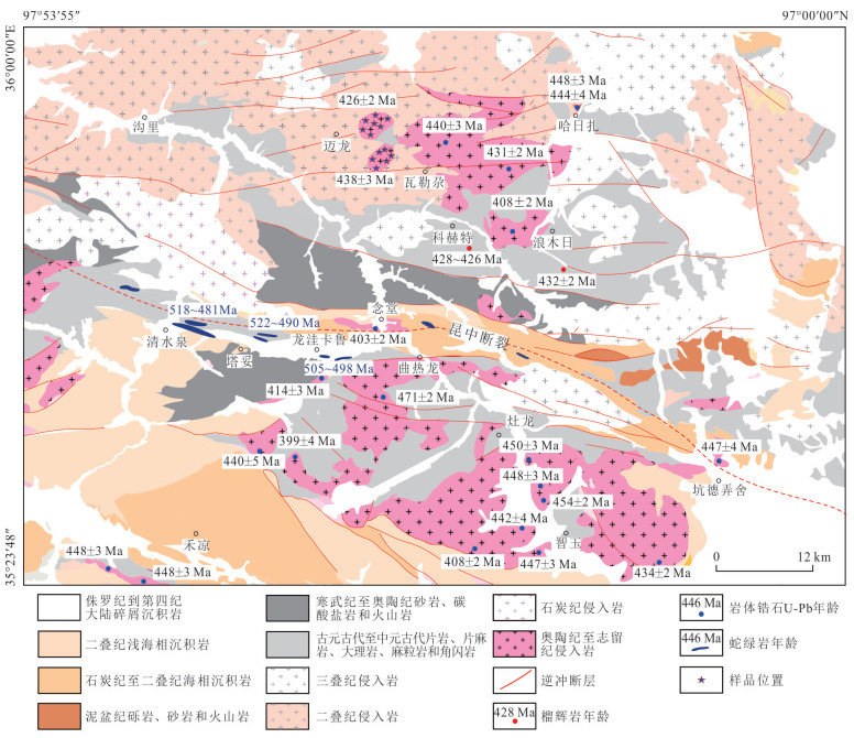
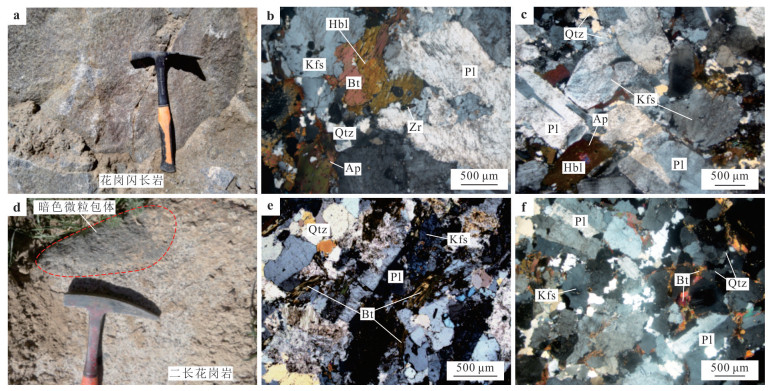
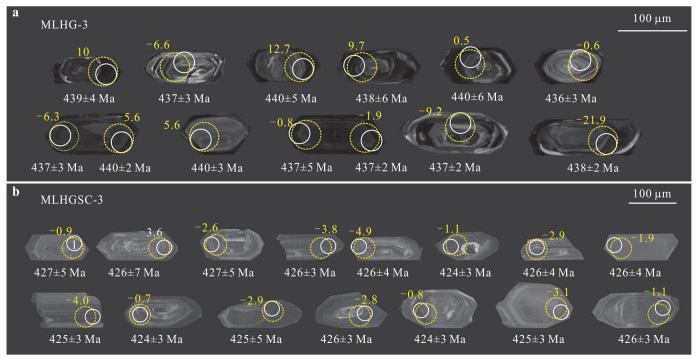
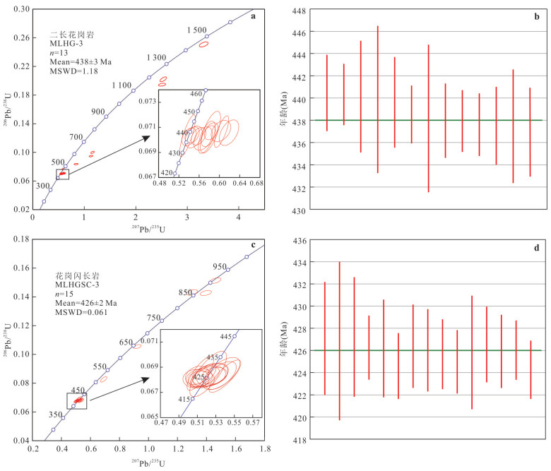
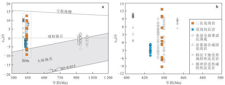
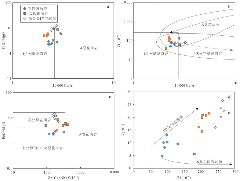
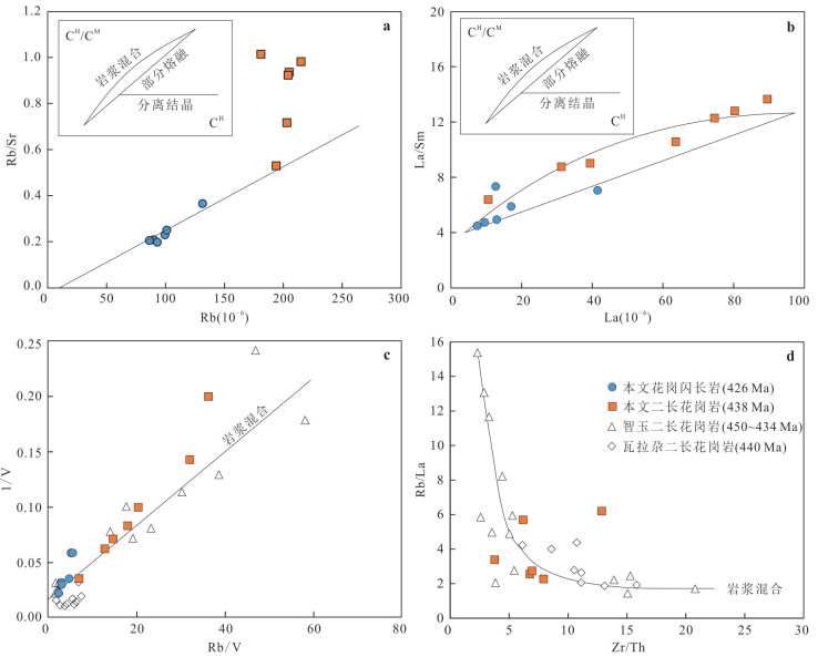
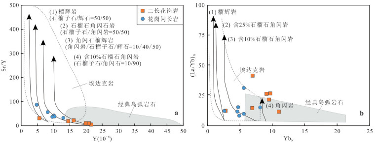
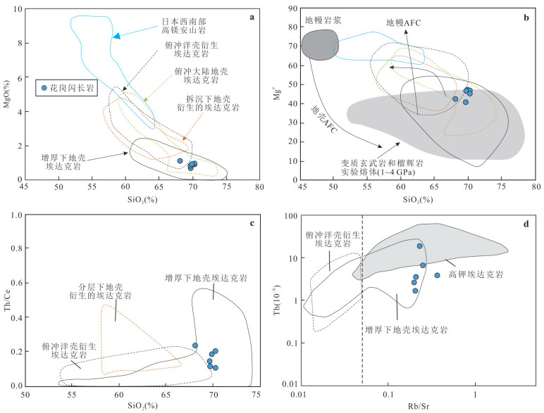
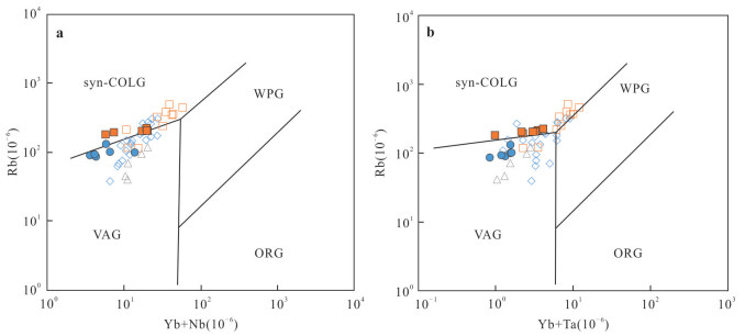
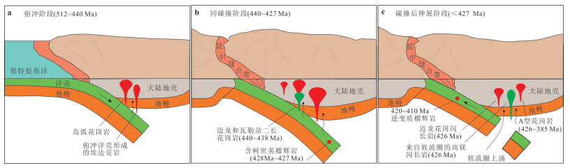
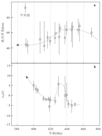
The Silurian magmatic rocks of the East Kunlun Orogen are of great significance in determining the collisional evolution process of the proto-Tethys Ocean. In this study, the petrographic, chronological, geochemical and Hf isotope analysis were carried out for Mailong granodiorite and monzogranite exposed in the Gouli area of the eastern section of the East Kunlun orogenic belt, and the rock genesis and formation were discussed accordingly construction background. The results show that the zircon weighted mean ages of Mailong monzonite and granodiorite are 438±3 Ma and 426±2 Ma, which indicated it was formed in Early Silurian and Late Silurian. The granodiorite is characterized by high silic, enrichment of alkaline, but depletion in calcium, magnesium, titanium and phosphorus. The A/CNK values range from 1.01 to 1.08.The rock is obviously enriched in large ion lithophile elements (LILE; K, Rb, Sr, U, Th etc.) and depleted in high field strength elements (HFSE; Nb, Ta, Ti etc.), with negative Eu anomalies. The zircon εHf (t) value has a wide range (from -3.54 to -0.56), and the two-stage mode age T2DM (Hf) is 1 805 to 592 Ma. The granodiorite is characterized by high aluminum, high strontium content, high Sr/Y and (La/Yb)N ratio and lower yttrium content. The total amount of rare earth elements in the rock is low, the differentiation between light and heavy rare earth elements is obvious, with positive Eu anomaly characteristics. εHf(t) ranges from -4.9 to -0.7, and the two-stage model age T2DM (Hf) is 1 559 to 1 332 Ma. The monzonite showing characteristics of highly fractionated I-type granites, it is formed by a high degree of separation and crystallization after the mixing of felsic magma in the lower crust and mafic magma in the mantle. But the granodiorite has the characteristics of adakite, it is formed by subsequent crystallization after partial melting of the thickened juvenile lower crust. Combining with new regional studies, the monzonite and granodiorite may have been formed in a syn-collision environment and a transition environment from syn-collision to post-collision extension. It proposes that the East Kunlun area began to enter the syn-collision stage at least in the Early Silurian (440 Ma), experiencing a period of rapid continental collision (440-427 Ma), and due to slab break-off began to transform from the syn-collision stage to the post-collision extension stage between 427 to 425 Ma.
The Silurian magmatic rocks of the East Kunlun Orogen are of great significance in determining the collisional evolution process of the proto-Tethys Ocean. In this study, the petrographic, chronological, geochemical and Hf isotope analysis were carried out for Mailong granodiorite and monzogranite exposed in the Gouli area of the eastern section of the East Kunlun orogenic belt, and the rock genesis and formation were discussed accordingly construction background. The results show that the zircon weighted mean ages of Mailong monzonite and granodiorite are 438±3 Ma and 426±2 Ma, which indicated it was formed in Early Silurian and Late Silurian. The granodiorite is characterized by high silic, enrichment of alkaline, but depletion in calcium, magnesium, titanium and phosphorus. The A/CNK values range from 1.01 to 1.08.The rock is obviously enriched in large ion lithophile elements (LILE; K, Rb, Sr, U, Th etc.) and depleted in high field strength elements (HFSE; Nb, Ta, Ti etc.), with negative Eu anomalies. The zircon εHf (t) value has a wide range (from -3.54 to -0.56), and the two-stage mode age T2DM (Hf) is 1 805 to 592 Ma. The granodiorite is characterized by high aluminum, high strontium content, high Sr/Y and (La/Yb)N ratio and lower yttrium content. The total amount of rare earth elements in the rock is low, the differentiation between light and heavy rare earth elements is obvious, with positive Eu anomaly characteristics. εHf(t) ranges from -4.9 to -0.7, and the two-stage model age T2DM (Hf) is 1 559 to 1 332 Ma. The monzonite showing characteristics of highly fractionated I-type granites, it is formed by a high degree of separation and crystallization after the mixing of felsic magma in the lower crust and mafic magma in the mantle. But the granodiorite has the characteristics of adakite, it is formed by subsequent crystallization after partial melting of the thickened juvenile lower crust. Combining with new regional studies, the monzonite and granodiorite may have been formed in a syn-collision environment and a transition environment from syn-collision to post-collision extension. It proposes that the East Kunlun area began to enter the syn-collision stage at least in the Early Silurian (440 Ma), experiencing a period of rapid continental collision (440-427 Ma), and due to slab break-off began to transform from the syn-collision stage to the post-collision extension stage between 427 to 425 Ma.
2025, 50(4): 1470-1484.
doi: 10.3799/dqkx.2024.077
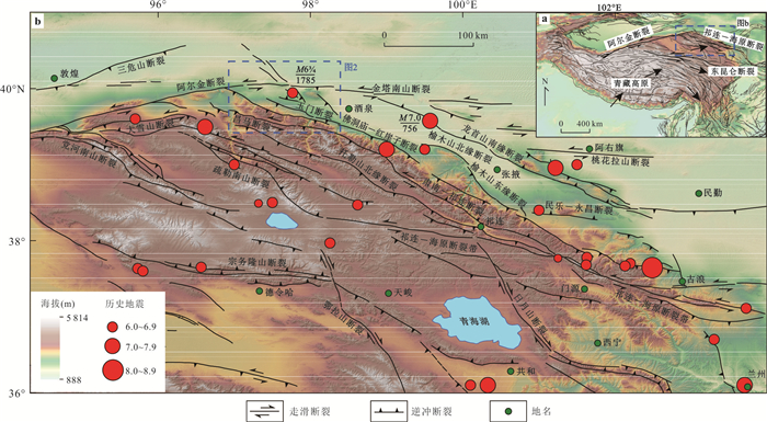
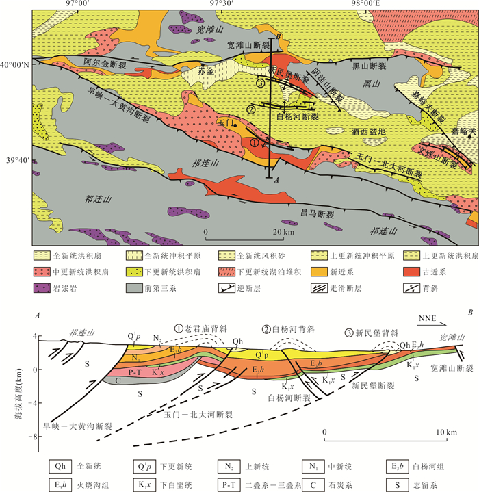
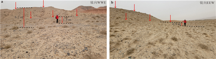
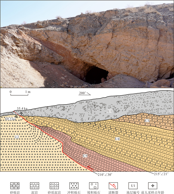
Abstract:
The Xinminpu fault is the northernmost reverse fault-fold belt in the Jiuxi Basin which is at the western of Hexi Corridor, still active in the Late Holocene and its offset geomorphology is clear. In this paper, cumulative offset of Xinminpu fault and co-seismic surface offset of the 1785 Huihuibao Earthquake are determined from tectonic geomorphology by high-precision unmanned aerial vehicle SfM photogrammetry and fine interpretation of offset geomorphology. Based on high-resolution topographic and geomorphologic data, a total of 90 groups of fault scarp offset were measured and counted, and combined with cumulative offset probability distribution plot, seven offset clusters were obtained, and it is inferred that about seven paleoseismic events occurred in Late Quaternary of Xinminpu fault, with quasi-periodic recurrence characteristics, and that the latest two peak offset of 0.9 and 1.5 m corresponded to the earthquake in 1785 and a paleoseismic event at 3.8±0.3 ka ago, respectively. Based on average coseismic offset of 0.9 m, the magnitude of the 1785 Huihuibao earthquake is about M6.6, which is consistent with historical seismic results. Combined with the listric fault model, the vertical slip rate of Xinminpu fault since Holocene was determined as 0.1±0.02 mm/a, and the horizontal shortening rate was about 0.18±0.06 mm/a. Comprehensive analysis shows that the 1785 Huihuibao earthquake was an inverse fault-fold type earthquake on Xinminpu fault, which is similar to the seismogenic mechanism of the 2003 Ms6.1, Ms5.8 Minle-Shandan earthquake in Gansu Province and the 2002 Yumen Ms5.9 earthquake that occurred in the central of the Hexi Corridor, indicating that it has a reverse fault-folding type seismic mechanism in the basin of Hexi Corridor, and further research and seismic defense for this type of seismic tectonic belts should be strengthened in the future.
The Xinminpu fault is the northernmost reverse fault-fold belt in the Jiuxi Basin which is at the western of Hexi Corridor, still active in the Late Holocene and its offset geomorphology is clear. In this paper, cumulative offset of Xinminpu fault and co-seismic surface offset of the 1785 Huihuibao Earthquake are determined from tectonic geomorphology by high-precision unmanned aerial vehicle SfM photogrammetry and fine interpretation of offset geomorphology. Based on high-resolution topographic and geomorphologic data, a total of 90 groups of fault scarp offset were measured and counted, and combined with cumulative offset probability distribution plot, seven offset clusters were obtained, and it is inferred that about seven paleoseismic events occurred in Late Quaternary of Xinminpu fault, with quasi-periodic recurrence characteristics, and that the latest two peak offset of 0.9 and 1.5 m corresponded to the earthquake in 1785 and a paleoseismic event at 3.8±0.3 ka ago, respectively. Based on average coseismic offset of 0.9 m, the magnitude of the 1785 Huihuibao earthquake is about M6.6, which is consistent with historical seismic results. Combined with the listric fault model, the vertical slip rate of Xinminpu fault since Holocene was determined as 0.1±0.02 mm/a, and the horizontal shortening rate was about 0.18±0.06 mm/a. Comprehensive analysis shows that the 1785 Huihuibao earthquake was an inverse fault-fold type earthquake on Xinminpu fault, which is similar to the seismogenic mechanism of the 2003 Ms6.1, Ms5.8 Minle-Shandan earthquake in Gansu Province and the 2002 Yumen Ms5.9 earthquake that occurred in the central of the Hexi Corridor, indicating that it has a reverse fault-folding type seismic mechanism in the basin of Hexi Corridor, and further research and seismic defense for this type of seismic tectonic belts should be strengthened in the future.
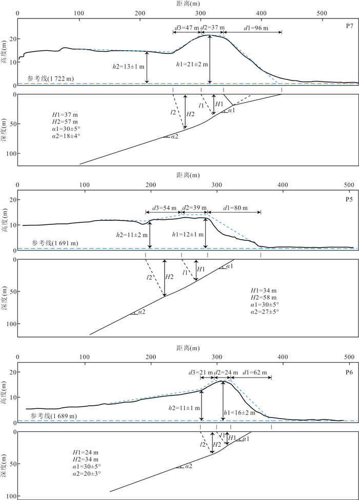
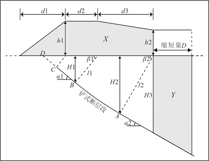
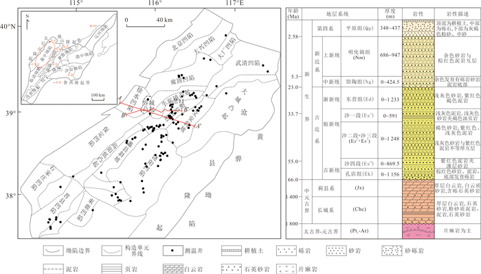
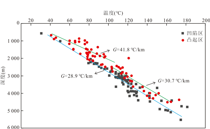
2025, 50(4): 1485-1498.
doi: 10.3799/dqkx.2024.031
Abstract:
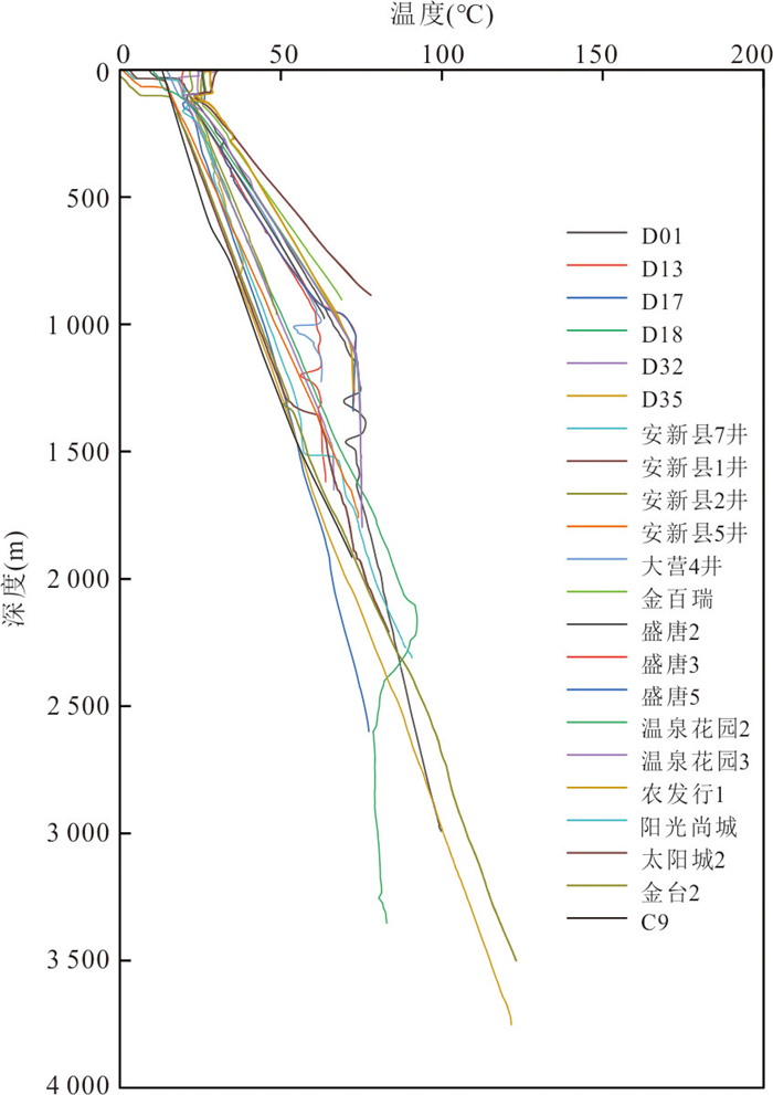
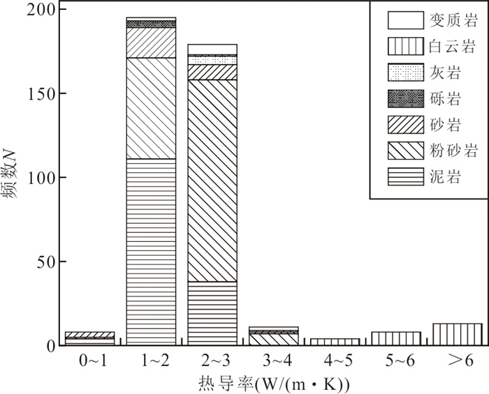
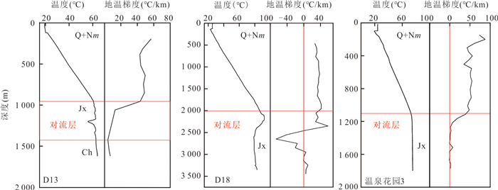
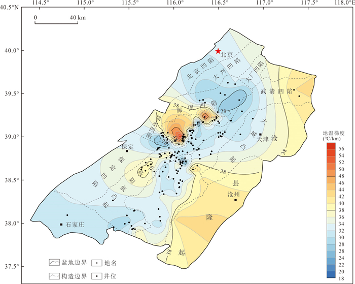
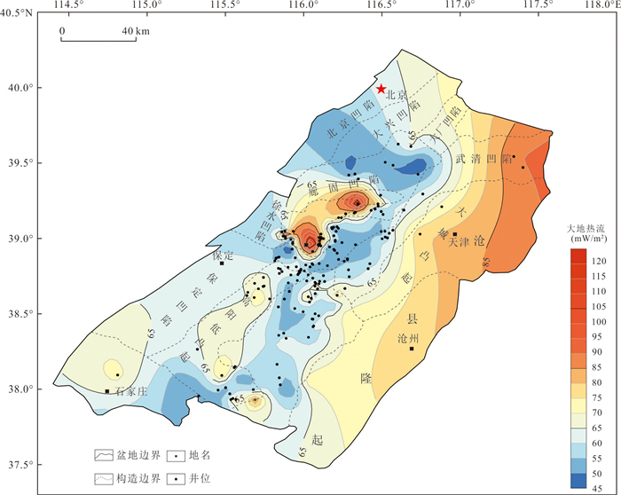
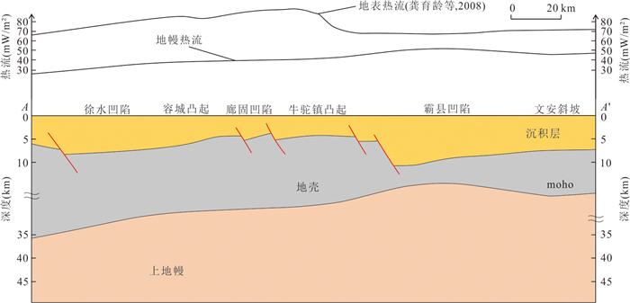
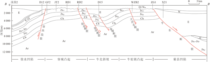
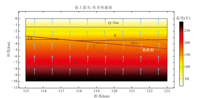
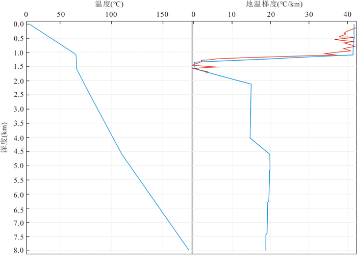
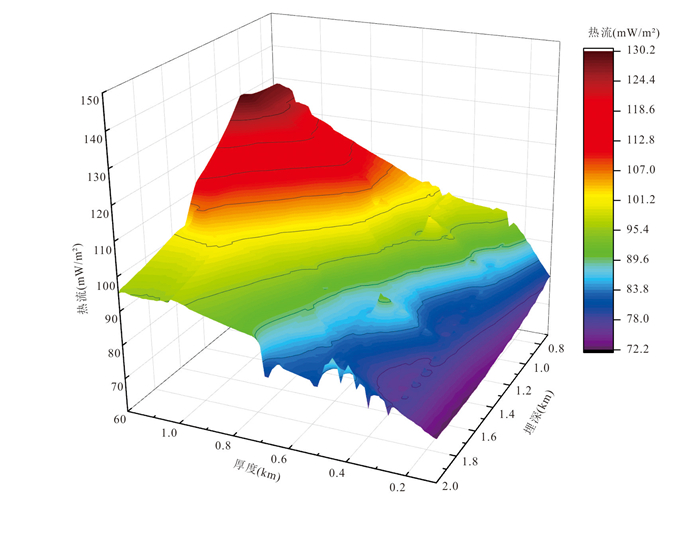
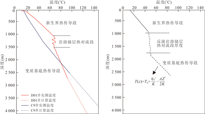
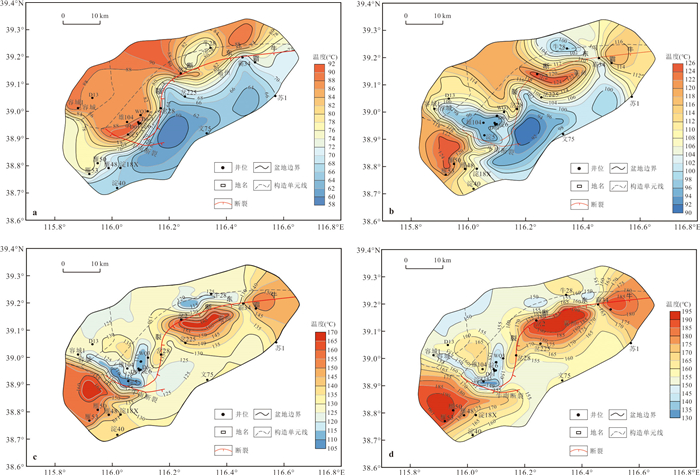
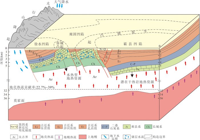
The Jizhong Depression, Bohai Bay Basin, has enormous potential for geothermal resource development, but currently only the genesis mechanism of shallow to mid-temperature geothermal resources has been extensively researched, and the genesis mechanism of deep and high-temperature geothermal resources remains unclear. Based on regional geology, geothermal geology, and rock thermal properties, in this study it analyzed the characteristics and controlling factors of the deep temperature field in the study area and explored the deep and high-temperature heat accumulation mechanism under complex heat transfer processes of conduction and convection. The temperature gradient and heatflow in Jizhong Depression of the Bohai Bay Basin are relatively high, with a temperature gradient ranging from 27.4 ℃/km to 39.7 ℃/km, with an average of about 34.8℃/km, and a heatflow ranging from 50 mW/m2 to 70 mW/m2. The temperature field is affected by rock thermal conductivity, basement structures, and groundwater flow, and has complex differences in both plane and vertical distribution. Based on measured data, it was found that the shallow temperature is high but the deep temperature is low in the convex areas, and the shallow temperature is low but the deep temperature is high in the depressed areas, leading to the deep and high-temperature geothermal resources largely concentrated in the depressions within 5 000 m depth in Jizhong Depression, with the reservoir temperature reaching 190 ℃, and which can serve as potential favorable targets for exploring hot dry rock resources. The characteristics of hydrothermal geothermal resources in the uplift area and deep potential hot dry rock geothermal resources in the Jizhong Depression are studied from the perspectives of geological structure, source, storage, cap, and fluid, and a model of the accumulation of shallow hydrothermal geothermal resources and deep potential hot dry rock geothermal resources in the studied area was established. This study deepened our understanding of the genesis mechanisms and distribution patterns of deep and high-temperature geothermal resources in Jizhong Depression and even the Bohai Bay Basin, and has significant reference value for the exploration and utilization of hot dry rock geothermal resources.
The Jizhong Depression, Bohai Bay Basin, has enormous potential for geothermal resource development, but currently only the genesis mechanism of shallow to mid-temperature geothermal resources has been extensively researched, and the genesis mechanism of deep and high-temperature geothermal resources remains unclear. Based on regional geology, geothermal geology, and rock thermal properties, in this study it analyzed the characteristics and controlling factors of the deep temperature field in the study area and explored the deep and high-temperature heat accumulation mechanism under complex heat transfer processes of conduction and convection. The temperature gradient and heatflow in Jizhong Depression of the Bohai Bay Basin are relatively high, with a temperature gradient ranging from 27.4 ℃/km to 39.7 ℃/km, with an average of about 34.8℃/km, and a heatflow ranging from 50 mW/m2 to 70 mW/m2. The temperature field is affected by rock thermal conductivity, basement structures, and groundwater flow, and has complex differences in both plane and vertical distribution. Based on measured data, it was found that the shallow temperature is high but the deep temperature is low in the convex areas, and the shallow temperature is low but the deep temperature is high in the depressed areas, leading to the deep and high-temperature geothermal resources largely concentrated in the depressions within 5 000 m depth in Jizhong Depression, with the reservoir temperature reaching 190 ℃, and which can serve as potential favorable targets for exploring hot dry rock resources. The characteristics of hydrothermal geothermal resources in the uplift area and deep potential hot dry rock geothermal resources in the Jizhong Depression are studied from the perspectives of geological structure, source, storage, cap, and fluid, and a model of the accumulation of shallow hydrothermal geothermal resources and deep potential hot dry rock geothermal resources in the studied area was established. This study deepened our understanding of the genesis mechanisms and distribution patterns of deep and high-temperature geothermal resources in Jizhong Depression and even the Bohai Bay Basin, and has significant reference value for the exploration and utilization of hot dry rock geothermal resources.
2025, 50(4): 1499-1513.
doi: 10.3799/dqkx.2024.018
Abstract:
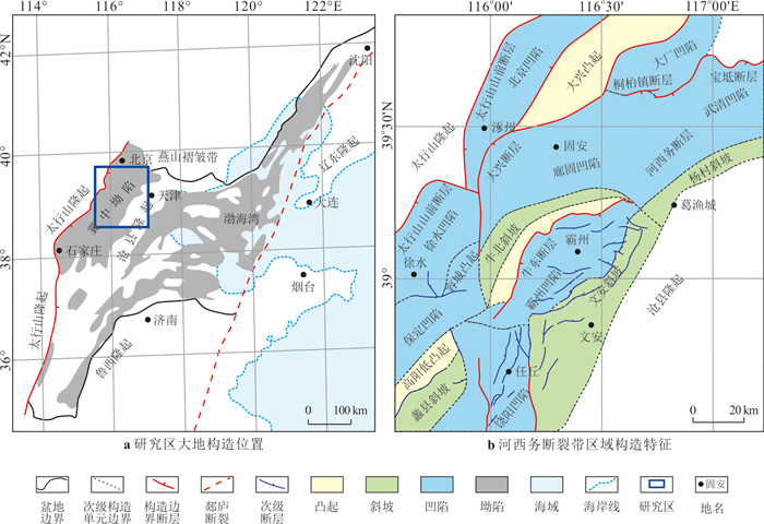
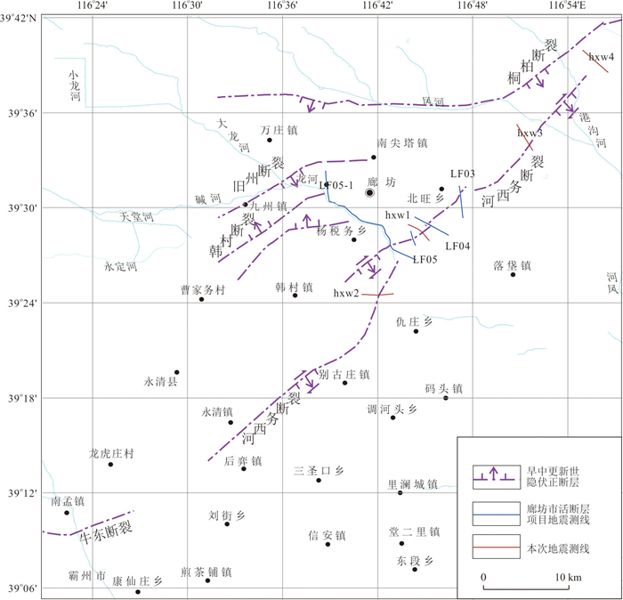
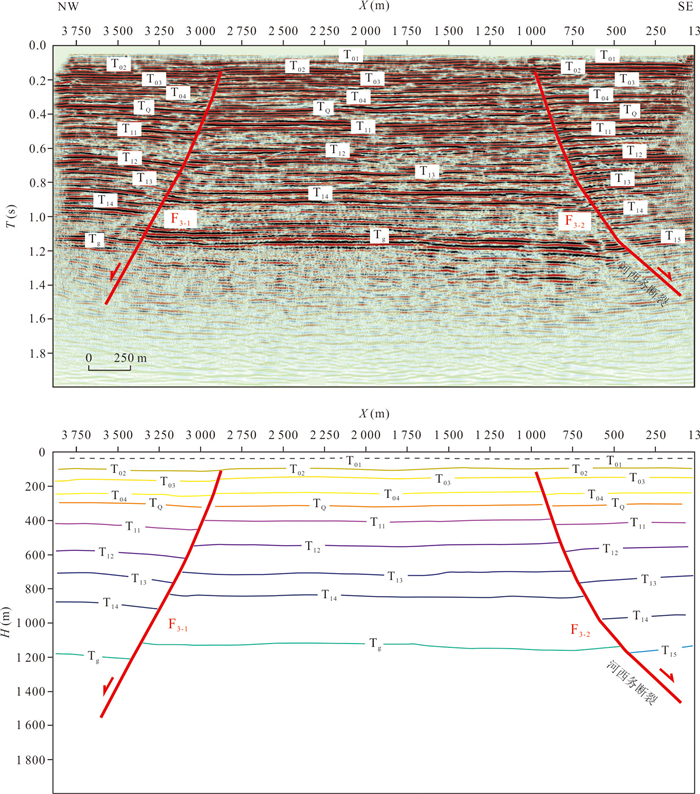
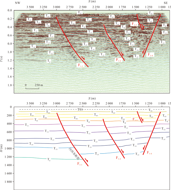
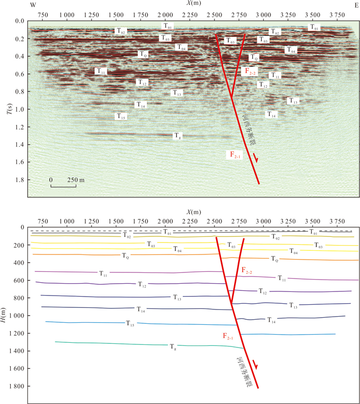
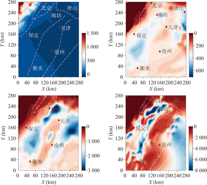
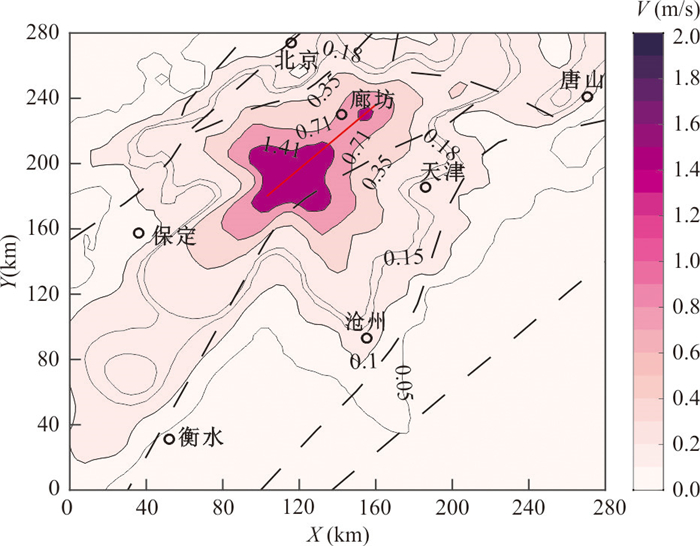
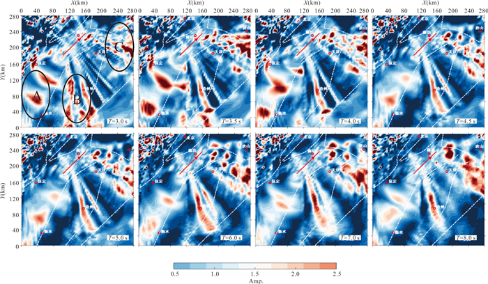
The Hexiwu fault is a large-scale Quaternary fault in the hinterland of the Beijing-Tianjin-Hebei urban agglomeration, and a series of shallow artificial seismic surveys and drillhole joint profiles have been carried out around the fault, which further revealed that the fracture is an active fracture in the early Late Pleistocene. Recently, Tianjin Seismological Bureau completed four 28T controlled-source artificial seismic surveys across the rupture, providing new evidence for the study of the rupture characteristics and activity of the rupture. The artificial seismic profiles show that: (1) the fracture extends northward and ends between Gaowang Highway and Jingtang Highway; (2) the depths of the shallowest upper fault point on different profiles vary, but generally reach more than 150 m, which indicates that the Heximo Fracture has a segmented distribution, but the rupture activity basically belongs to the same period. Regional data show that the fracture extends southward to connect with the Niudong Fault, which together form a 100 km-long fracture zone, and there is a possibility of earthquakes of magnitude 7 or above. From the demand of Beijing-Tianjin-Hebei urban agglomeration to prevent the risk of large earthquakes, numerical simulation of the rupture setting earthquake Mw7.3 is carried out to analyze the impacts of potential long-period ground shaking on the Beijing-Tianjin-Hebei region.
The Hexiwu fault is a large-scale Quaternary fault in the hinterland of the Beijing-Tianjin-Hebei urban agglomeration, and a series of shallow artificial seismic surveys and drillhole joint profiles have been carried out around the fault, which further revealed that the fracture is an active fracture in the early Late Pleistocene. Recently, Tianjin Seismological Bureau completed four 28T controlled-source artificial seismic surveys across the rupture, providing new evidence for the study of the rupture characteristics and activity of the rupture. The artificial seismic profiles show that: (1) the fracture extends northward and ends between Gaowang Highway and Jingtang Highway; (2) the depths of the shallowest upper fault point on different profiles vary, but generally reach more than 150 m, which indicates that the Heximo Fracture has a segmented distribution, but the rupture activity basically belongs to the same period. Regional data show that the fracture extends southward to connect with the Niudong Fault, which together form a 100 km-long fracture zone, and there is a possibility of earthquakes of magnitude 7 or above. From the demand of Beijing-Tianjin-Hebei urban agglomeration to prevent the risk of large earthquakes, numerical simulation of the rupture setting earthquake Mw7.3 is carried out to analyze the impacts of potential long-period ground shaking on the Beijing-Tianjin-Hebei region.
2025, 50(4): 1514-1530.
doi: 10.3799/dqkx.2024.096
Abstract:
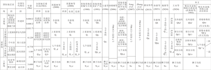
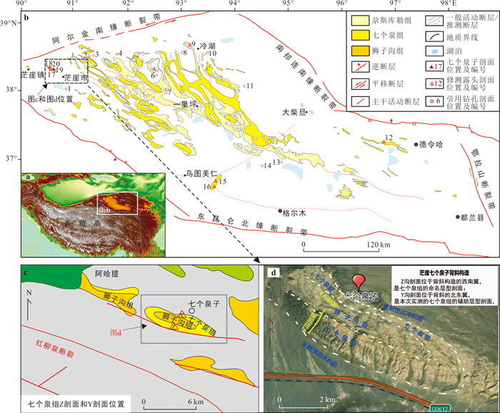
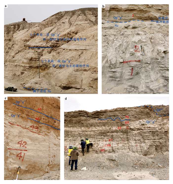
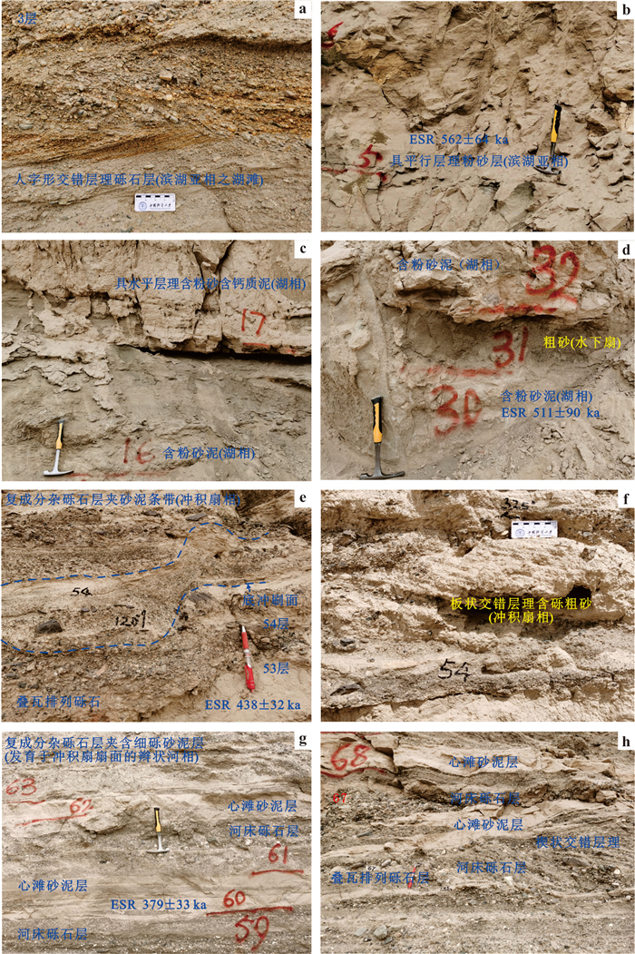
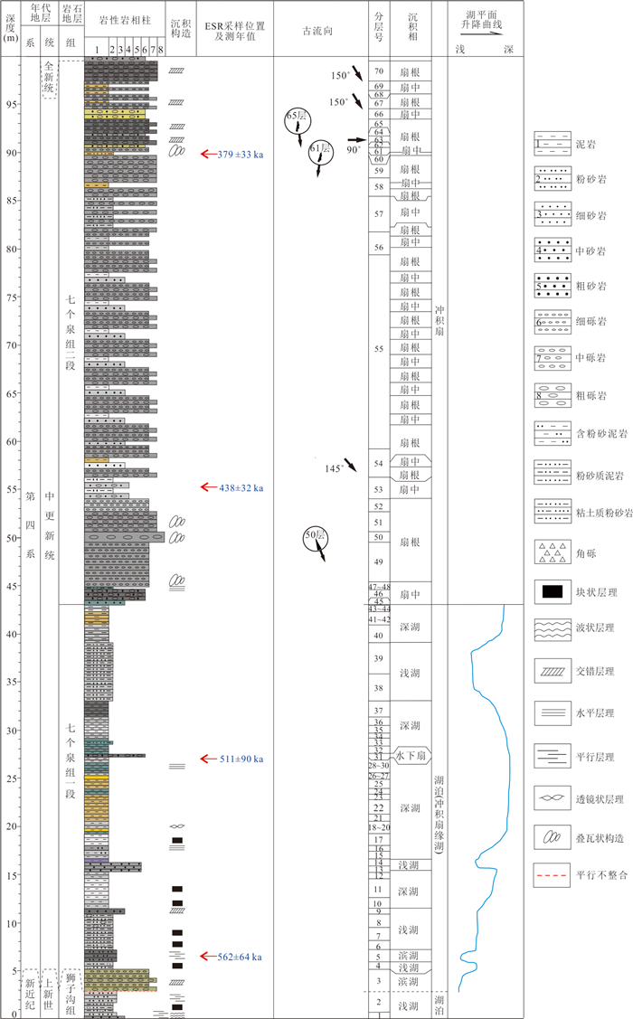
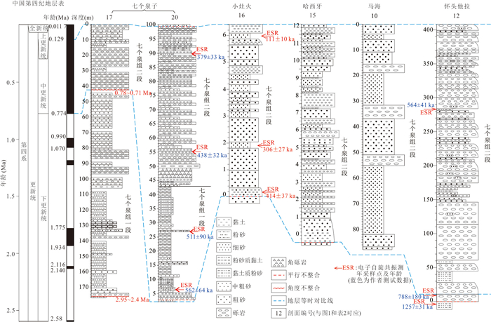
In response to the previous problems of unclear lithologic and petrographic meanings of the Qigequan Formation in Qaidam Basin, especially the controversial issue of whether its depositional age extends to the Middle Pleistocene. In this paper it re-conducted a fine study of the auxiliary type section (Section Y) of the Qigequan Formation located in the north of the type section (Section Z) in the Qigequanzi area of Mangya City, Qinghai Province. It obtained for the first time four ESR ages from the bottom to the top of the section, which are 562±64 ka, 511±90 ka, 438± 32 ka, and 379±33 ka, respectively, further confirming the existence of the Middle Pleistocene sedimentary sequences in the Qigequan Formation. Based on a detailed analysis of the lithological and petrographic assemblage of the Section Y and Section Z, the Qigequanzi Section is divided into two parts, the upper fine and the lower coarse.The lower part of the section is assigned to Member 1 of Qigequan Formation for the mud-sand lake sequences, and the upper part is assigned to the Member 2 of Qigequan Formation for the gravel-sand rhythmic sequence of the alluvial fan stratigraphy.Combined with the paleomagnetic age obtained in Section Z and ESR ages obtained in Section Y, the depositional age of the Member 1 of Qigequan Formation is limited mainly to the Early Pleistocene, and that of the Member 2 of Qigequan Formation mainly to the Middle Pleistocene.Although Member 1 of the Qigequan Formation is at the lower part and Member 2 is at the upper part, there is a phase transition between the late Early Pleistocene and the early Middle Pleistocene, which means that the stratigraphic interface between the two members is time-disconnected. In this paper it compares the type section of Qigequan Formation with other contemporaneous stratum in the Qaidam Basin, and provides new stratigraphic materials for the analysis of Quaternary petrographic paleogeography in the region as well as for the exploration of Quaternary potassium salts and other important minerals.
In response to the previous problems of unclear lithologic and petrographic meanings of the Qigequan Formation in Qaidam Basin, especially the controversial issue of whether its depositional age extends to the Middle Pleistocene. In this paper it re-conducted a fine study of the auxiliary type section (Section Y) of the Qigequan Formation located in the north of the type section (Section Z) in the Qigequanzi area of Mangya City, Qinghai Province. It obtained for the first time four ESR ages from the bottom to the top of the section, which are 562±64 ka, 511±90 ka, 438± 32 ka, and 379±33 ka, respectively, further confirming the existence of the Middle Pleistocene sedimentary sequences in the Qigequan Formation. Based on a detailed analysis of the lithological and petrographic assemblage of the Section Y and Section Z, the Qigequanzi Section is divided into two parts, the upper fine and the lower coarse.The lower part of the section is assigned to Member 1 of Qigequan Formation for the mud-sand lake sequences, and the upper part is assigned to the Member 2 of Qigequan Formation for the gravel-sand rhythmic sequence of the alluvial fan stratigraphy.Combined with the paleomagnetic age obtained in Section Z and ESR ages obtained in Section Y, the depositional age of the Member 1 of Qigequan Formation is limited mainly to the Early Pleistocene, and that of the Member 2 of Qigequan Formation mainly to the Middle Pleistocene.Although Member 1 of the Qigequan Formation is at the lower part and Member 2 is at the upper part, there is a phase transition between the late Early Pleistocene and the early Middle Pleistocene, which means that the stratigraphic interface between the two members is time-disconnected. In this paper it compares the type section of Qigequan Formation with other contemporaneous stratum in the Qaidam Basin, and provides new stratigraphic materials for the analysis of Quaternary petrographic paleogeography in the region as well as for the exploration of Quaternary potassium salts and other important minerals.
2025, 50(4): 1531-1544.
doi: 10.3799/dqkx.2024.064
Abstract:
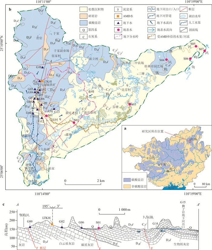
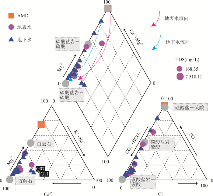
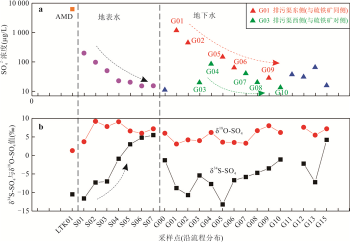
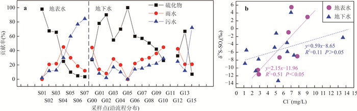
Acid mine drainage (AMD) can contribute to deterioration of the receiving water quality, accelerate the dissolution of carbonate rocks, leading to the release of CO2, which poses a wide range of hazards. Combined with the hydrogeological setting, hydrochemical and isotopic methods are employed to investigate the sources and migration mechanisms of pollutants in surface and groundwater of the Mamian mining area in Guilin, China. Results show that: (1) the chemical composition of surface water and groundwater mainly came from the weathering of carbonate and silicate rock, as well as the oxidation of sulfide, and Ca-HCO3 was the main water type in the study area, while some sites affected by AMD and domestic sewage wastewater changed to Ca-HCO3·SO4 and Ca·(K+Na)-HCO3 types; (2) sulfur and oxygen isotopes indicate that sulfide, rainwater and sewage were the three main SO42- sources for sampled surface-ground waters; and (3) changes in hydrochemical and isotopic composition indicate that the influence of AMD on surface water and groundwater gradually decreased along the flow directions, affecting to approximately 13.5 km and 1.5 km downstream, respectively. This study not only revealed the negative impact of AMD and human activities on the waters, provided basic data for the protection of water resources for the studied mine area. At the same time, the combination of isotope and water chemistry is proved to be an effective means to study the migration and transformation of pollutants in mining area, which provides a new idea for the study of pollutants in other mining areas.
Acid mine drainage (AMD) can contribute to deterioration of the receiving water quality, accelerate the dissolution of carbonate rocks, leading to the release of CO2, which poses a wide range of hazards. Combined with the hydrogeological setting, hydrochemical and isotopic methods are employed to investigate the sources and migration mechanisms of pollutants in surface and groundwater of the Mamian mining area in Guilin, China. Results show that: (1) the chemical composition of surface water and groundwater mainly came from the weathering of carbonate and silicate rock, as well as the oxidation of sulfide, and Ca-HCO3 was the main water type in the study area, while some sites affected by AMD and domestic sewage wastewater changed to Ca-HCO3·SO4 and Ca·(K+Na)-HCO3 types; (2) sulfur and oxygen isotopes indicate that sulfide, rainwater and sewage were the three main SO42- sources for sampled surface-ground waters; and (3) changes in hydrochemical and isotopic composition indicate that the influence of AMD on surface water and groundwater gradually decreased along the flow directions, affecting to approximately 13.5 km and 1.5 km downstream, respectively. This study not only revealed the negative impact of AMD and human activities on the waters, provided basic data for the protection of water resources for the studied mine area. At the same time, the combination of isotope and water chemistry is proved to be an effective means to study the migration and transformation of pollutants in mining area, which provides a new idea for the study of pollutants in other mining areas.

2025, 50(4): 1545-1558.
doi: 10.3799/dqkx.2023.201
Abstract:
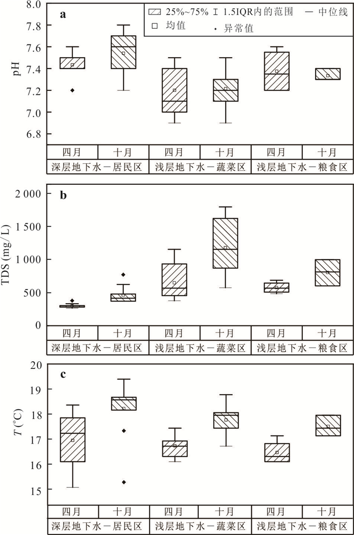
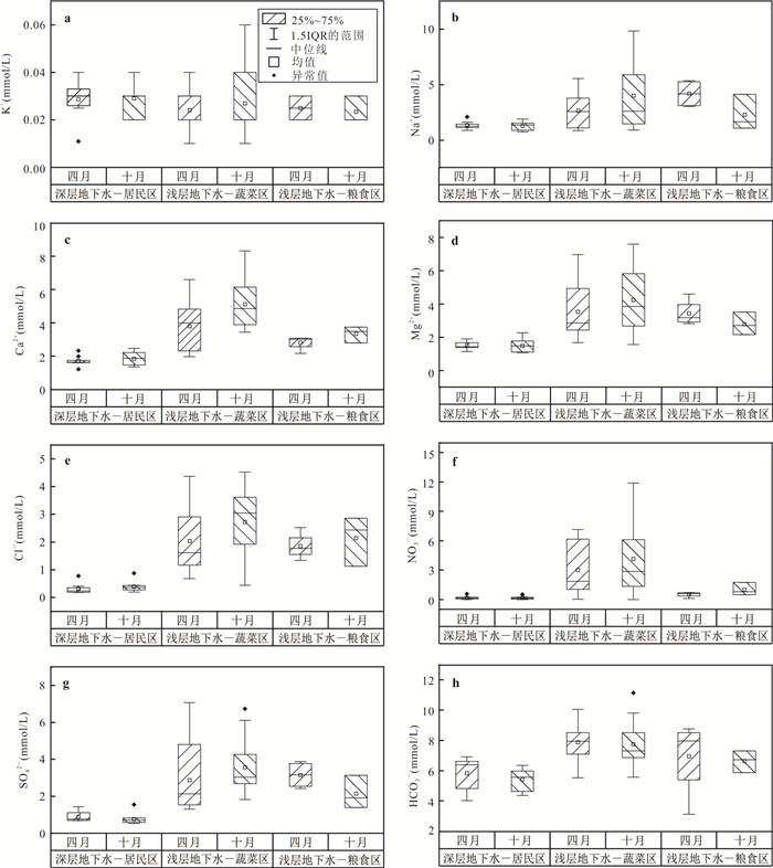
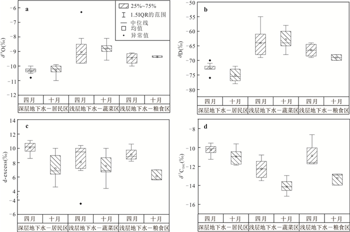
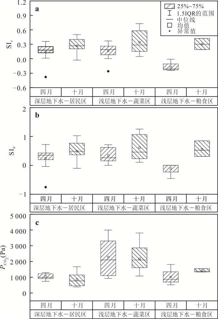
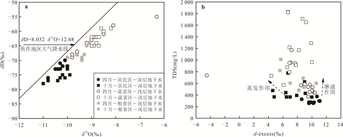
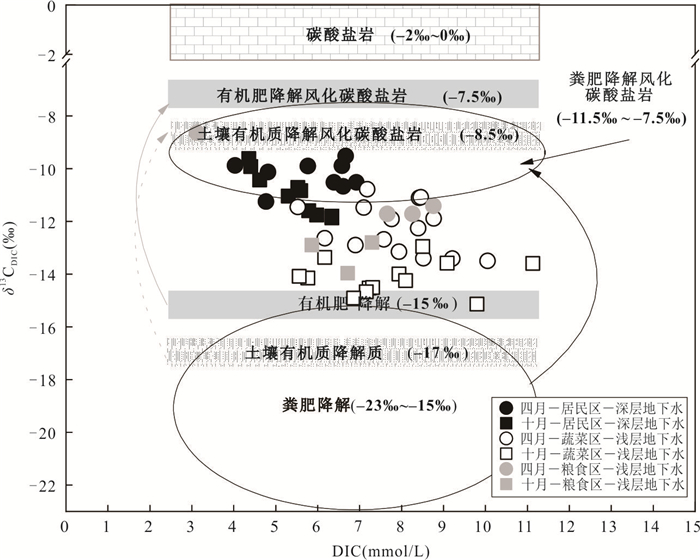
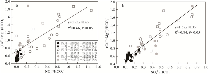
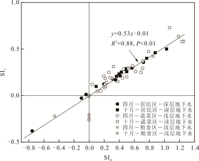
In the backdrop of global climate change, the quest for effective methods to sequester atmospheric carbon dioxide (CO2) is both urgent and indispensable. The acidifying substances generated by artificial inputs such as manure and chemical fertilizers in agricultural areas release more dissolved inorganic carbon (DIC) into shallow groundwater, altering the process of inorganic carbon cycling. However, the influence of heavy rain events on this process remains unclear. Shallow groundwater in a vegetable cultivation area in North Henan Province was selected as the primary research focus, while shallow groundwater samples from grain growing region and local deep groundwater samples were also collected in April and October 2021. The water chemistry composition, hydrogen and oxygen isotope compositions (δDH2O and δ18OH2O), and δ13CDIC compositions were analyzed to investigate the influence of rainfall processes on inorganic carbon cycling in shallow groundwater of agricultural areas. The results show that heavy rainfall led to more anthropogenic pollutants entering groundwater under the vegetable cultivation areas during the rainy season, resulting in an increase in mean TDS values from 649 mg/L in April to 1 195 mg/L in October, and a decrease in average δ13CDIC values from -12.25‰ to -14.14‰. The changes of mean TDS values and δ13CDIC values in groundwater under the vegetable cultivation areas were larger than those in groundwater under other sites, displaying more organic matter had entered and decomposed in the shallow groundwater under the vegetable cultivation areas. The average DIC concentrations varied little from 7.78 mmol/L in April to 7.74 mmol/L in October, however, as groundwater table elevated about 11 to 15 m after heavy rainfall, it implied more DIC input and thereby obviously increased carbon sink capacity in shallow groundwater. This study confirms the impact of anthropogenic inputs in vegetable cultivation areas on DIC in shallow groundwater and verifies that heavy rainfall will transport more DIC into shallow groundwater and increasing more dissolved components, elevating carbon sink capability of groundwater.
In the backdrop of global climate change, the quest for effective methods to sequester atmospheric carbon dioxide (CO2) is both urgent and indispensable. The acidifying substances generated by artificial inputs such as manure and chemical fertilizers in agricultural areas release more dissolved inorganic carbon (DIC) into shallow groundwater, altering the process of inorganic carbon cycling. However, the influence of heavy rain events on this process remains unclear. Shallow groundwater in a vegetable cultivation area in North Henan Province was selected as the primary research focus, while shallow groundwater samples from grain growing region and local deep groundwater samples were also collected in April and October 2021. The water chemistry composition, hydrogen and oxygen isotope compositions (δDH2O and δ18OH2O), and δ13CDIC compositions were analyzed to investigate the influence of rainfall processes on inorganic carbon cycling in shallow groundwater of agricultural areas. The results show that heavy rainfall led to more anthropogenic pollutants entering groundwater under the vegetable cultivation areas during the rainy season, resulting in an increase in mean TDS values from 649 mg/L in April to 1 195 mg/L in October, and a decrease in average δ13CDIC values from -12.25‰ to -14.14‰. The changes of mean TDS values and δ13CDIC values in groundwater under the vegetable cultivation areas were larger than those in groundwater under other sites, displaying more organic matter had entered and decomposed in the shallow groundwater under the vegetable cultivation areas. The average DIC concentrations varied little from 7.78 mmol/L in April to 7.74 mmol/L in October, however, as groundwater table elevated about 11 to 15 m after heavy rainfall, it implied more DIC input and thereby obviously increased carbon sink capacity in shallow groundwater. This study confirms the impact of anthropogenic inputs in vegetable cultivation areas on DIC in shallow groundwater and verifies that heavy rainfall will transport more DIC into shallow groundwater and increasing more dissolved components, elevating carbon sink capability of groundwater.
2025, 50(4): 1559-1574.
doi: 10.3799/dqkx.2023.211
Abstract:
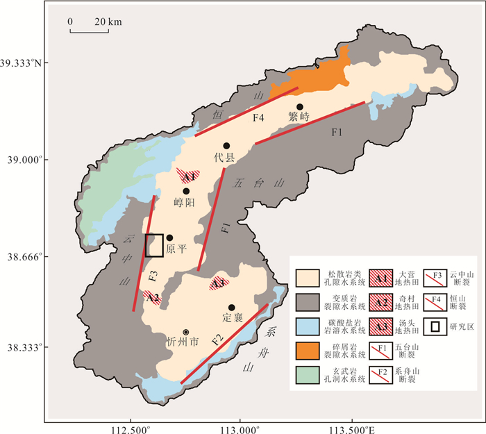
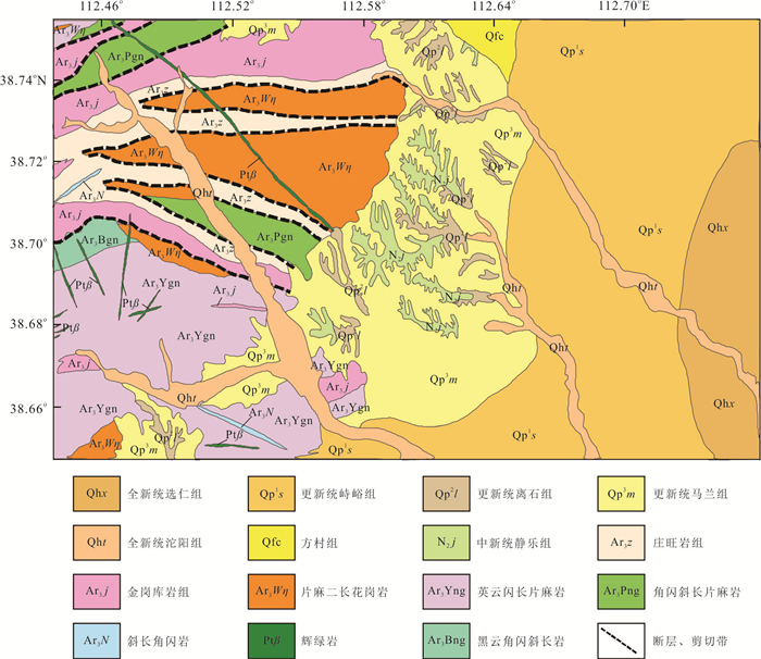
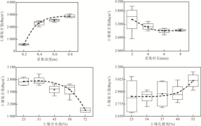
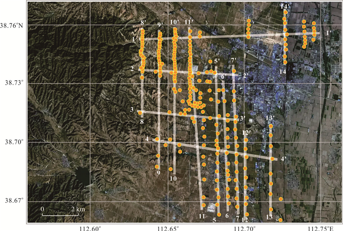
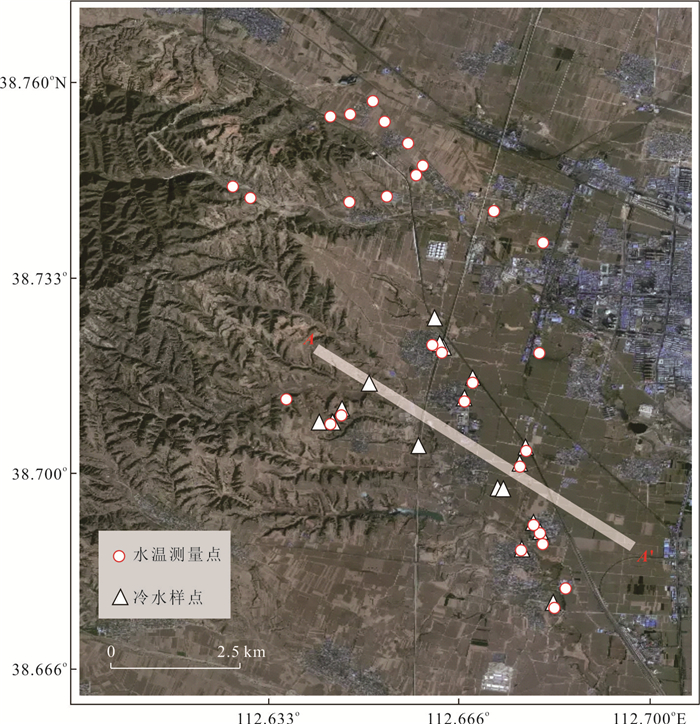
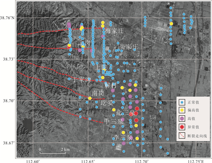
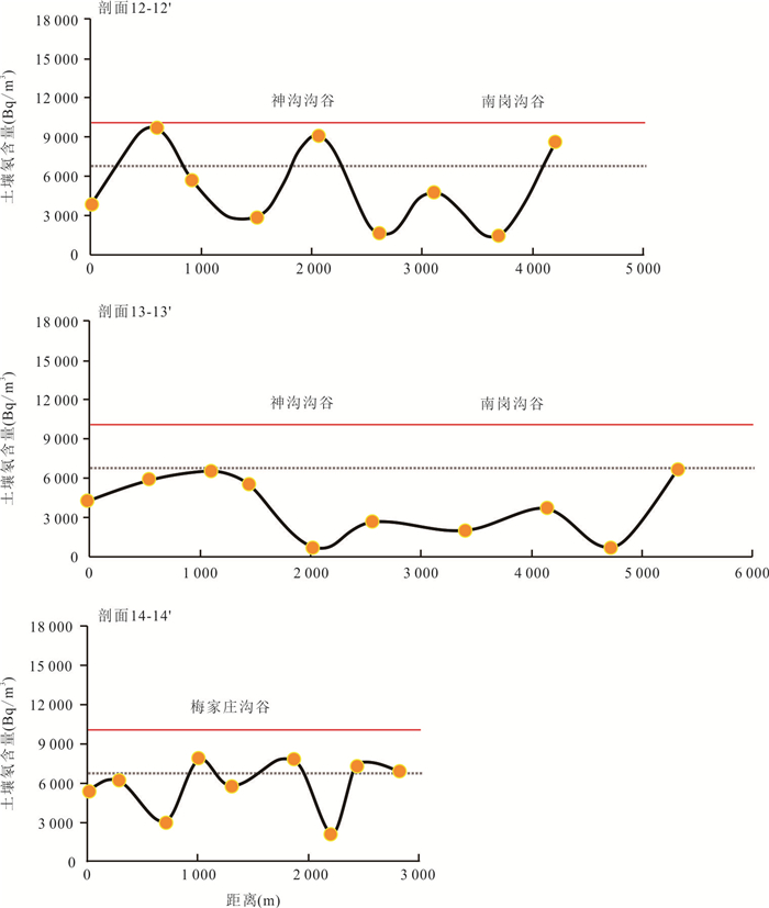
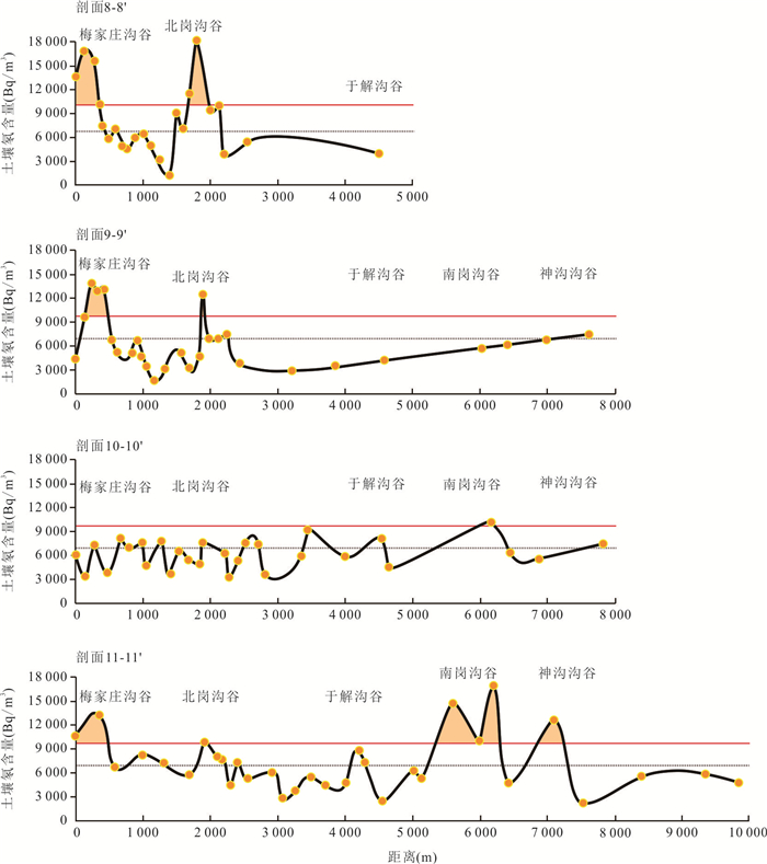
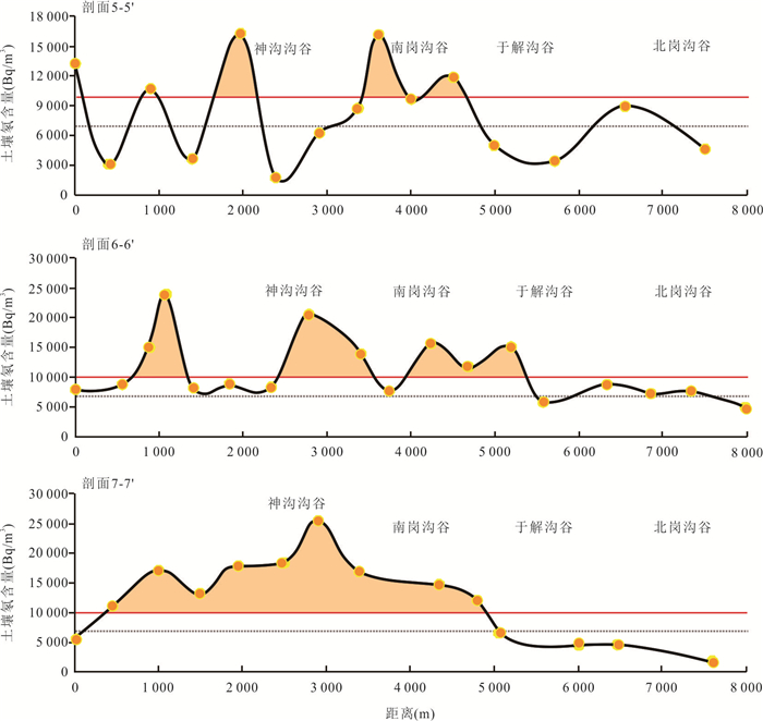
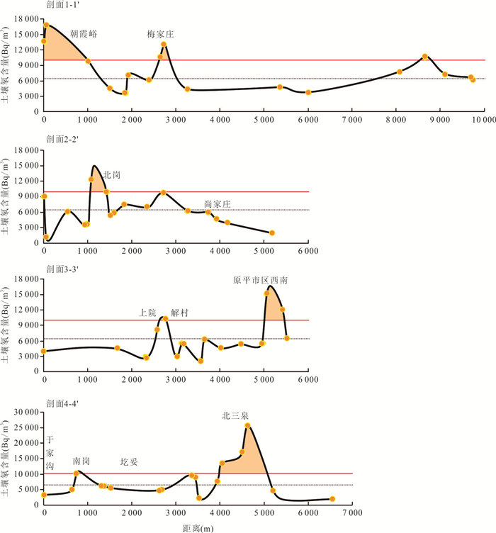
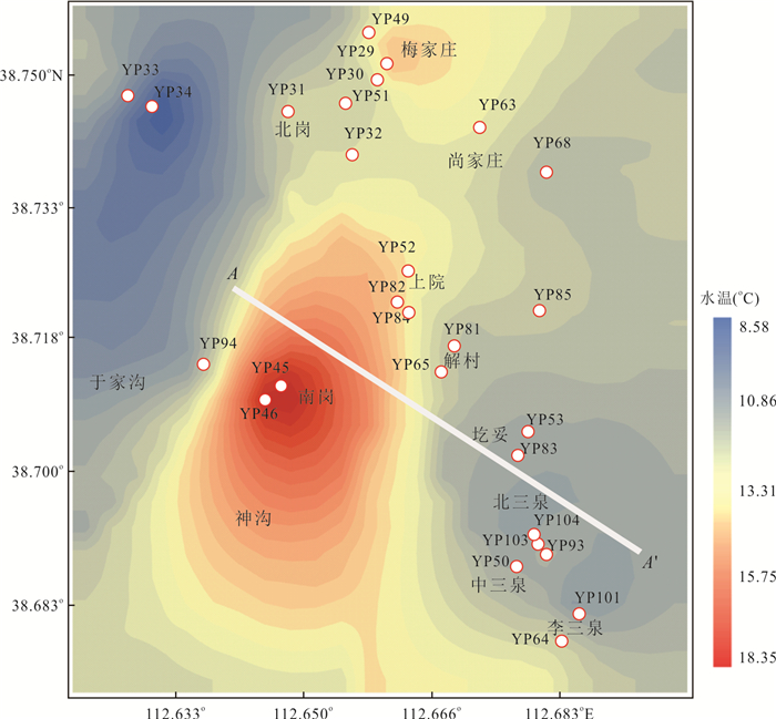
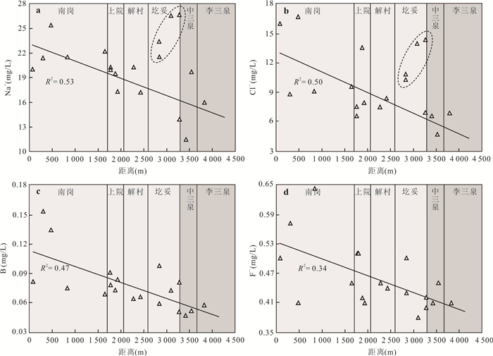
Soil radon measurement is one of the important geochemical exploration methods to investigate concealed fracture, and also an effective means to identify hydrothermal geothermal systems. In this paper it clarified the relationship between the test results of soil radon content and sampling depth, measurement time, soil porosity, soil humidity and optimizes the traditional soil radon measurement method. On this basis, choose the geothermal exploration in Shanxi Xinzhou Basin as a typical research area, based on the optimization of soil radon measurement method to identify the control of geothermal water flow main water fracture, supplemented by shallow groundwater temperature measurement and hydrogeochemical research, find out the distribution of hydrothermal geothermal type in the area. The results of this study are expected to be applied to the exploration practice of medium-low temperature convective geothermal system controlled by fracture.
Soil radon measurement is one of the important geochemical exploration methods to investigate concealed fracture, and also an effective means to identify hydrothermal geothermal systems. In this paper it clarified the relationship between the test results of soil radon content and sampling depth, measurement time, soil porosity, soil humidity and optimizes the traditional soil radon measurement method. On this basis, choose the geothermal exploration in Shanxi Xinzhou Basin as a typical research area, based on the optimization of soil radon measurement method to identify the control of geothermal water flow main water fracture, supplemented by shallow groundwater temperature measurement and hydrogeochemical research, find out the distribution of hydrothermal geothermal type in the area. The results of this study are expected to be applied to the exploration practice of medium-low temperature convective geothermal system controlled by fracture.
2025, 50(4): 1575-1584.
doi: 10.3799/dqkx.2024.033
Abstract:
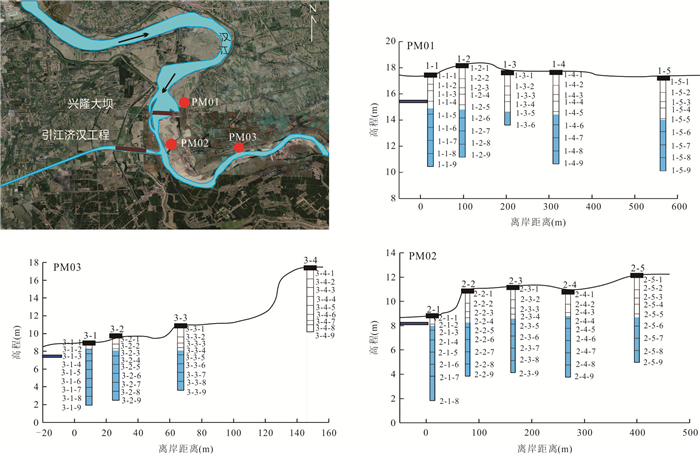
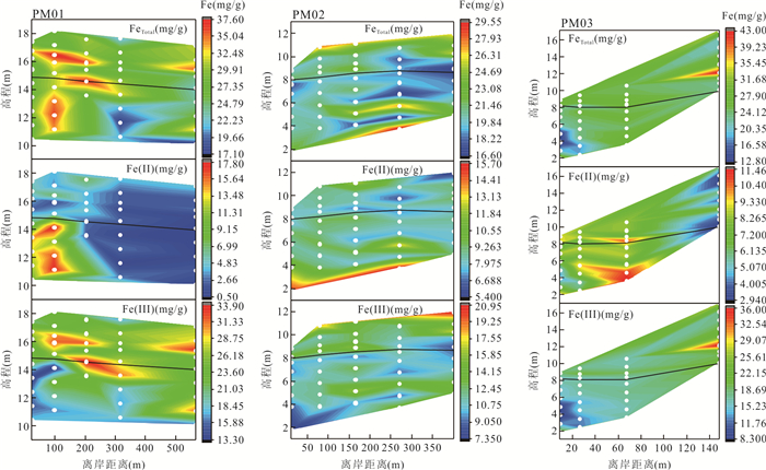
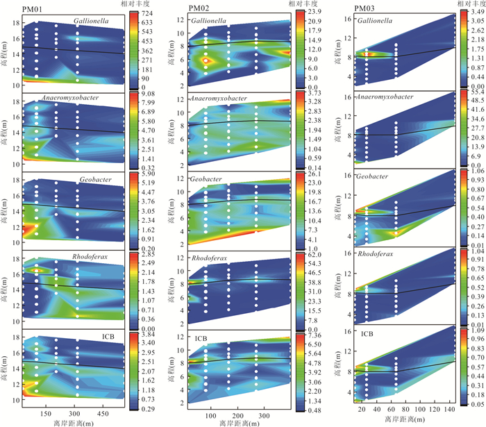
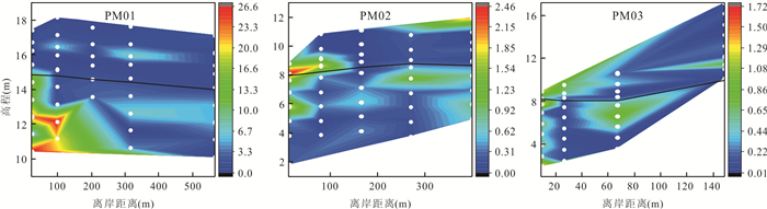
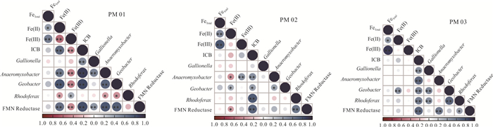
Flavin mononucleotide (FMN) reductases are important enzymes secreted by microorganisms to facilitate iron oxidation and reduction through electron transfer. In order to explore the feasibility of using FMN reductase genes as indicators of iron cycling microbes, in this study it focused on the interaction zone at the lower reaches of Han River as the research area. In the study it investigated the distributional correlations of different forms Fe, representative iron-cycling microorganisms, and the relative abundance of FMN reductase genes in sediments from three differently characterized riverwater-groundwater interaction zone profiles. The results indicate that (1) Fe(Ⅱ) accumulates in the area below the water table closer to the river, while Fe(Ⅲ) mainly accumulates in the area at the water table line or farther away from the river; (2) iron cycling microbes and FMN reductases were mainly distributed in the areas below the groundwater level close to the river bank or around the water level, with different areas of aggregation for different iron cycling bacteria; (3) there was a significant positive correlation between the total abundance of iron cycling microbes and FMN reductase genes. These findings validate the feasibility of using FMN reductase genes as indicators of iron cycling microbes.
Flavin mononucleotide (FMN) reductases are important enzymes secreted by microorganisms to facilitate iron oxidation and reduction through electron transfer. In order to explore the feasibility of using FMN reductase genes as indicators of iron cycling microbes, in this study it focused on the interaction zone at the lower reaches of Han River as the research area. In the study it investigated the distributional correlations of different forms Fe, representative iron-cycling microorganisms, and the relative abundance of FMN reductase genes in sediments from three differently characterized riverwater-groundwater interaction zone profiles. The results indicate that (1) Fe(Ⅱ) accumulates in the area below the water table closer to the river, while Fe(Ⅲ) mainly accumulates in the area at the water table line or farther away from the river; (2) iron cycling microbes and FMN reductases were mainly distributed in the areas below the groundwater level close to the river bank or around the water level, with different areas of aggregation for different iron cycling bacteria; (3) there was a significant positive correlation between the total abundance of iron cycling microbes and FMN reductase genes. These findings validate the feasibility of using FMN reductase genes as indicators of iron cycling microbes.
2025, 50(4): 1585-1598.
doi: 10.3799/dqkx.2024.030
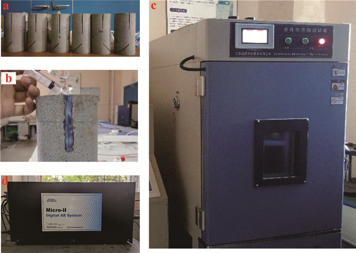
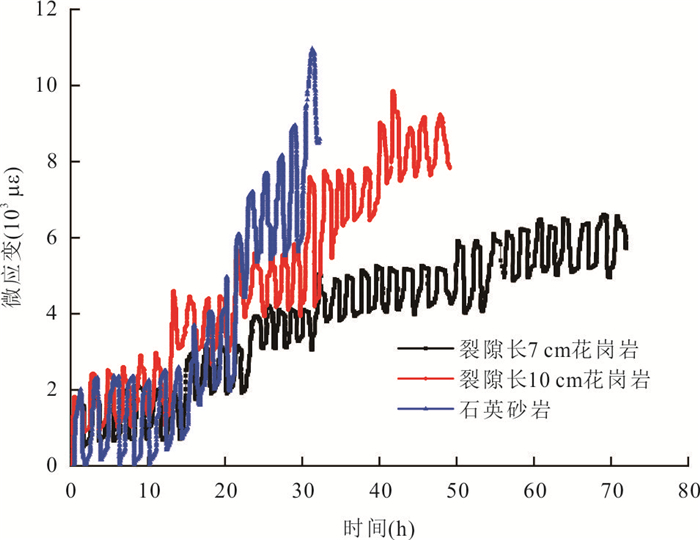
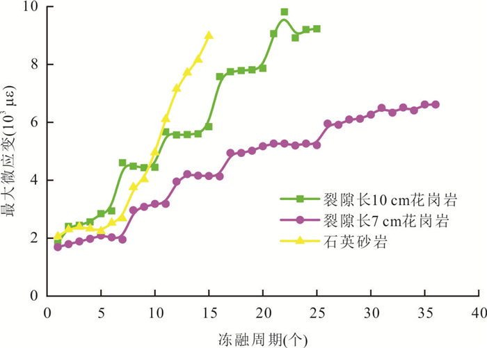
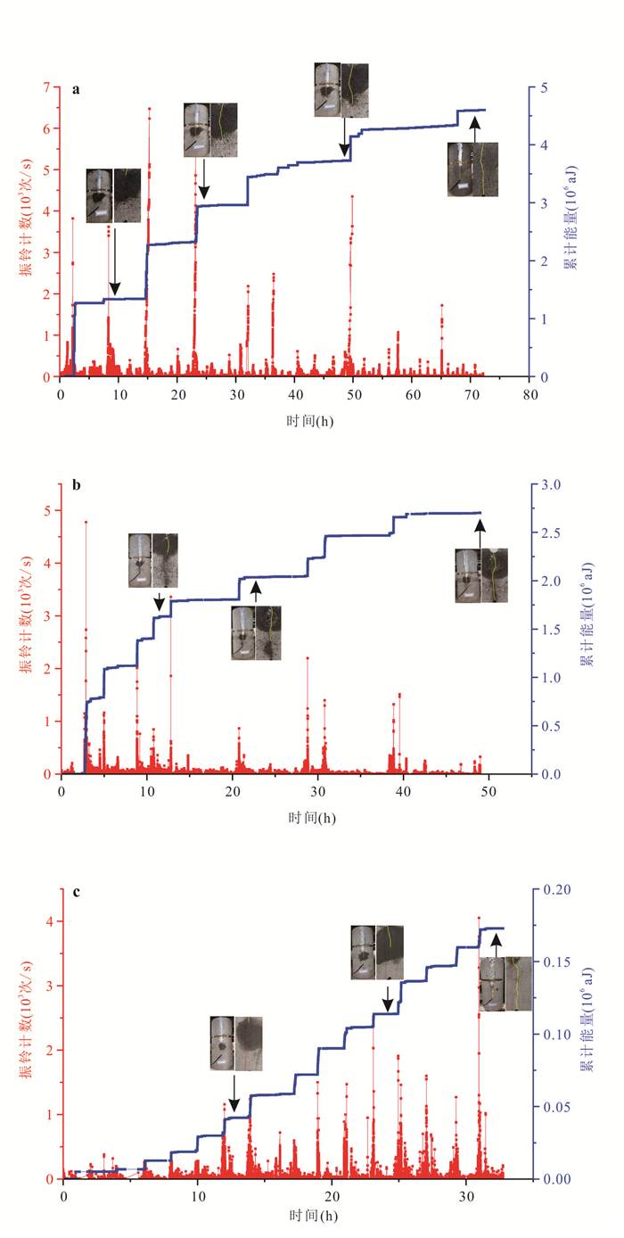
Abstract:
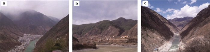
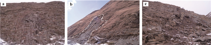
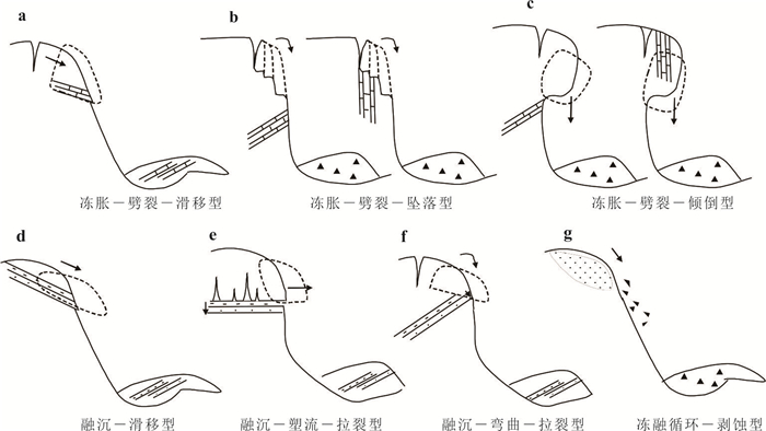
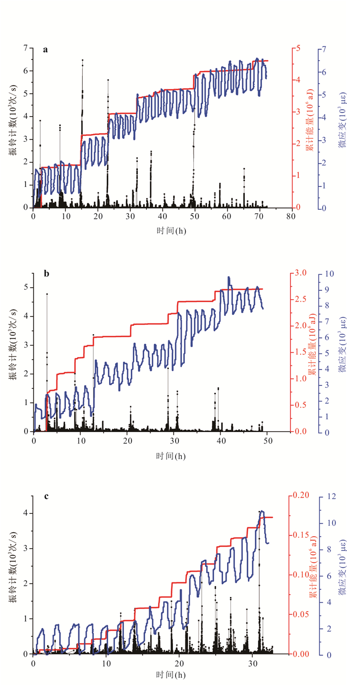
Under the influence of climate change, frost-weathered rock masses in high-altitude regions are prone to deterioration due to long-term freeze-thaw cycles. This deterioration can lead to sudden slope instability. To analyze the fracture mechanisms and corresponding hazard patterns under freeze-thaw cycles, it conducted field investigations on failure modes in high-altitude regions and freeze-thaw tests on fractured granite and quartz sandstone with varying crack lengths. By utilizing acoustic emission (AE) systems and strain testing systems, it analyzed the entire process of crack propagation at the end of the fissures, observing AE and microstrain curve variations. Based on experimental and theoretical discussions, it identified three main hazard patterns for fractured rock masses under freeze-thaw conditions: frost heaving, thaw subsidence, and freeze-thaw cycling. For the widely observed frost heaving pattern, the rock sample tests revealed that crack propagation occurred vertically downward from the crack ends, without deviation or secondary phenomena. While granite samples exhibited more pronounced initial crack propagation, quartz sandstone fissures tended to connect earlier. The AE count for granite showed an initial increase followed by a decrease, while quartz sandstone exhibited a steady count initially, which rapidly increased with more freeze-thaw cycles. Fracture mechanics analysis indicates that the expansion characteristics of fissured rock masses under freeze-thaw conditions are primarily influenced by rock type and crack length. Consequently, the formation of hazards in high-altitude regions is controlled by rock type and crack propagation. The research provides a theoretical basis for understanding the evolution of fractured rock masses and their hazard patterns in cold regions.
Under the influence of climate change, frost-weathered rock masses in high-altitude regions are prone to deterioration due to long-term freeze-thaw cycles. This deterioration can lead to sudden slope instability. To analyze the fracture mechanisms and corresponding hazard patterns under freeze-thaw cycles, it conducted field investigations on failure modes in high-altitude regions and freeze-thaw tests on fractured granite and quartz sandstone with varying crack lengths. By utilizing acoustic emission (AE) systems and strain testing systems, it analyzed the entire process of crack propagation at the end of the fissures, observing AE and microstrain curve variations. Based on experimental and theoretical discussions, it identified three main hazard patterns for fractured rock masses under freeze-thaw conditions: frost heaving, thaw subsidence, and freeze-thaw cycling. For the widely observed frost heaving pattern, the rock sample tests revealed that crack propagation occurred vertically downward from the crack ends, without deviation or secondary phenomena. While granite samples exhibited more pronounced initial crack propagation, quartz sandstone fissures tended to connect earlier. The AE count for granite showed an initial increase followed by a decrease, while quartz sandstone exhibited a steady count initially, which rapidly increased with more freeze-thaw cycles. Fracture mechanics analysis indicates that the expansion characteristics of fissured rock masses under freeze-thaw conditions are primarily influenced by rock type and crack length. Consequently, the formation of hazards in high-altitude regions is controlled by rock type and crack propagation. The research provides a theoretical basis for understanding the evolution of fractured rock masses and their hazard patterns in cold regions.
2025, 50(4): 1599-1611.
doi: 10.3799/dqkx.2024.029
Abstract:
To study the influence of anisotropy of rock mass structural plane on roughness evaluation, taking the rock mass on the high and steep slope of a railway Chada site in southeast Tibet as the research object, the integrated photogram technology of unmanned aerial vehicle was used to extract the high-density point cloud of the structural plane in the study area and cut the outline of the structural plane. The roughness coefficient JRC and fractal dimension D were calculated by the modified straight edge method and the box dimension method respectively. The new JRC and D formulas are fitted and verified by digital Barton standard lines. 15 structural planes formed under shear and tension were selected and the new formula was used to calculate the JRC in large quantities. The results show that the shear surface roughness is anisotropic, and the JRC is smaller along the shear direction, larger along the vertical shear direction, and the fluctuation with sampling angle is small. The tensile surface roughness also has anisotropy but no obvious rule, and JRC fluctuates greatly with sampling angle. It is proved that the JRC anisotropy of structural planes with different mechanical origin is also different, and different sampling rules should be followed when evaluating roughness.
To study the influence of anisotropy of rock mass structural plane on roughness evaluation, taking the rock mass on the high and steep slope of a railway Chada site in southeast Tibet as the research object, the integrated photogram technology of unmanned aerial vehicle was used to extract the high-density point cloud of the structural plane in the study area and cut the outline of the structural plane. The roughness coefficient JRC and fractal dimension D were calculated by the modified straight edge method and the box dimension method respectively. The new JRC and D formulas are fitted and verified by digital Barton standard lines. 15 structural planes formed under shear and tension were selected and the new formula was used to calculate the JRC in large quantities. The results show that the shear surface roughness is anisotropic, and the JRC is smaller along the shear direction, larger along the vertical shear direction, and the fluctuation with sampling angle is small. The tensile surface roughness also has anisotropy but no obvious rule, and JRC fluctuates greatly with sampling angle. It is proved that the JRC anisotropy of structural planes with different mechanical origin is also different, and different sampling rules should be followed when evaluating roughness.
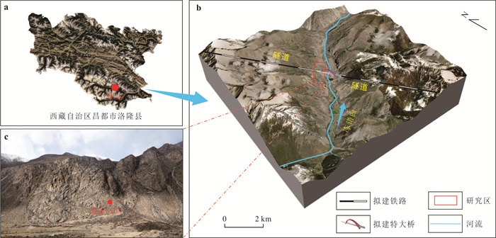
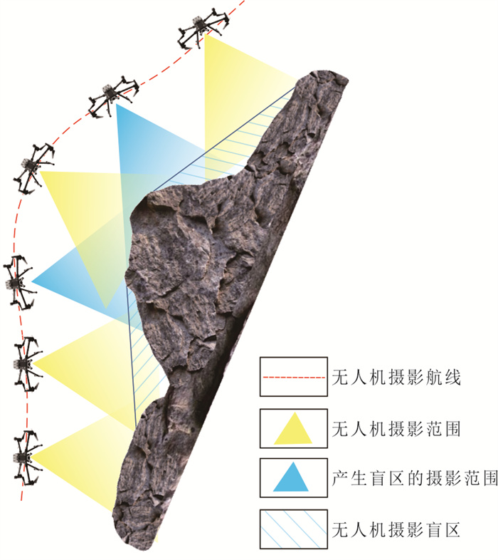
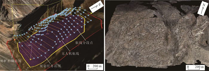
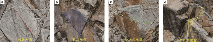
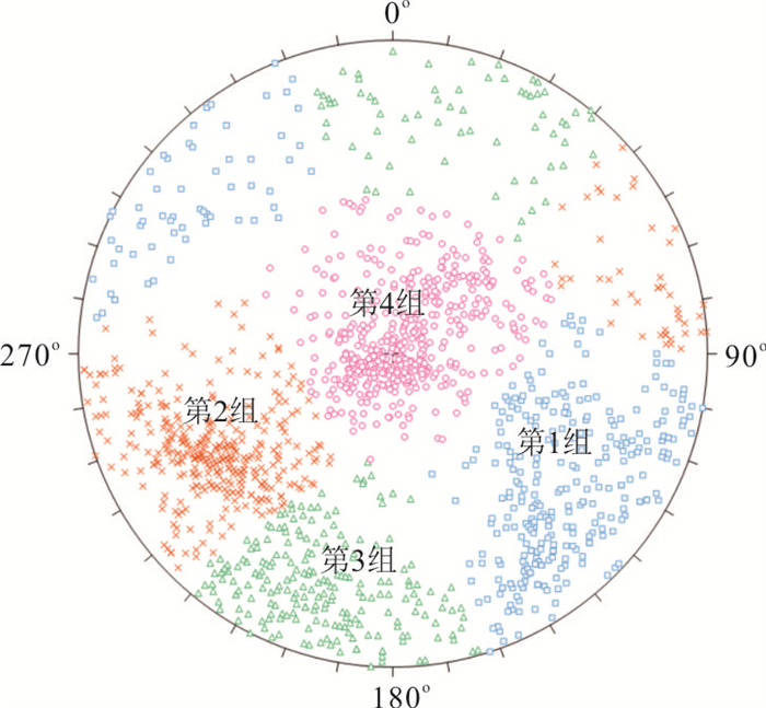
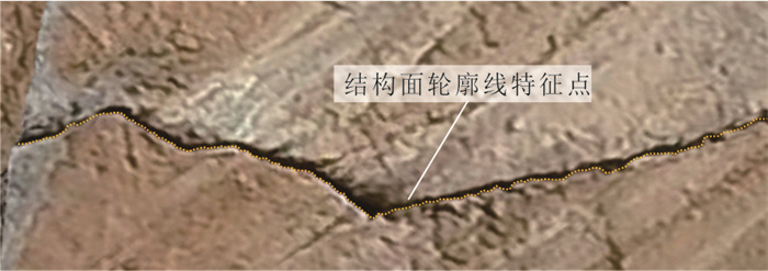
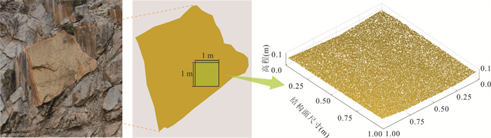
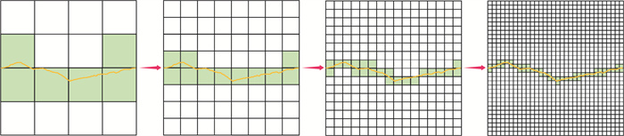
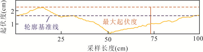
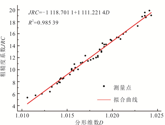
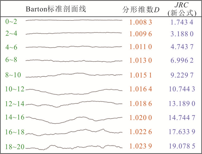
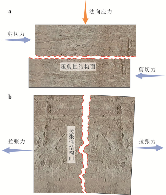
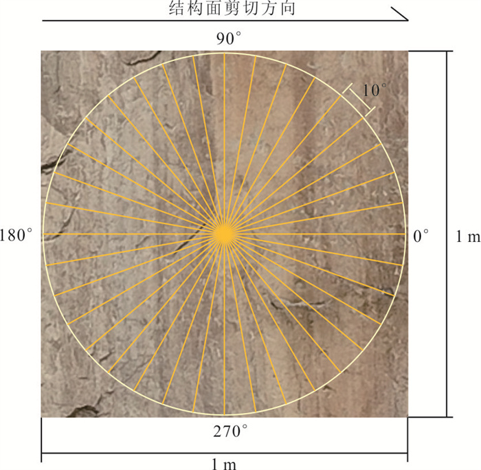
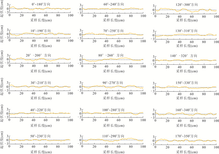
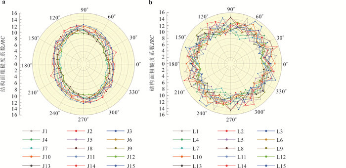
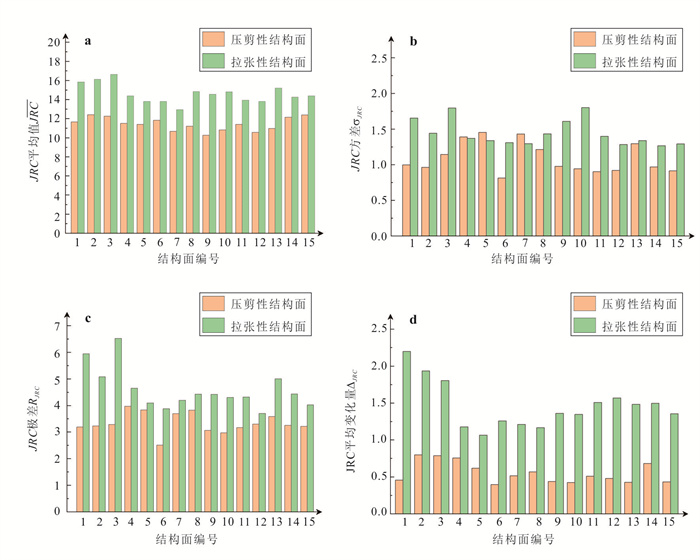
2025, 50(4): 1612-1624.
doi: 10.3799/dqkx.2024.032
Abstract:
Peat soil is a natural insulation material, which has a significant effect on the underlying frozen soil layer. Natural peat soil usually exists in the form of aggregates, and its particle size distribution has a spatial variability. However, the effect of gradings on the thermal conductivity is rarely reported. In this work, 66 laboratory tests were conducted on the peat soil to investigate the effects of coarse content, particle size ratio and water content on its thermal conductivity by a non-steady-state probe method.The results show that under the same relative density, the thermal conductivity of peat soil first increases and then decreases with the increase of coarse content, and reaches the peak value when the coarse content reaches 50%. For the peat soil with coarse dominated structure, the thermal conductivity increases distinctly with the increase of particle size ratio. However, the effect of particle size ratio reduces in the fine dominated structure. For a given void ratio, the thermal conductivity increases with the rising coarse content due to the thermal resistance and the particle contacts which are affected by particle size distribution; it increases with increasing particle size ratio in fine grain dominated structure but decreases in coarse grain dominated structure. In addition, the thermal conductivity of peat soil increases significantly with increasing water content, and the growth rate varies with the internal pores and the water distribution in the pores.
Peat soil is a natural insulation material, which has a significant effect on the underlying frozen soil layer. Natural peat soil usually exists in the form of aggregates, and its particle size distribution has a spatial variability. However, the effect of gradings on the thermal conductivity is rarely reported. In this work, 66 laboratory tests were conducted on the peat soil to investigate the effects of coarse content, particle size ratio and water content on its thermal conductivity by a non-steady-state probe method.The results show that under the same relative density, the thermal conductivity of peat soil first increases and then decreases with the increase of coarse content, and reaches the peak value when the coarse content reaches 50%. For the peat soil with coarse dominated structure, the thermal conductivity increases distinctly with the increase of particle size ratio. However, the effect of particle size ratio reduces in the fine dominated structure. For a given void ratio, the thermal conductivity increases with the rising coarse content due to the thermal resistance and the particle contacts which are affected by particle size distribution; it increases with increasing particle size ratio in fine grain dominated structure but decreases in coarse grain dominated structure. In addition, the thermal conductivity of peat soil increases significantly with increasing water content, and the growth rate varies with the internal pores and the water distribution in the pores.
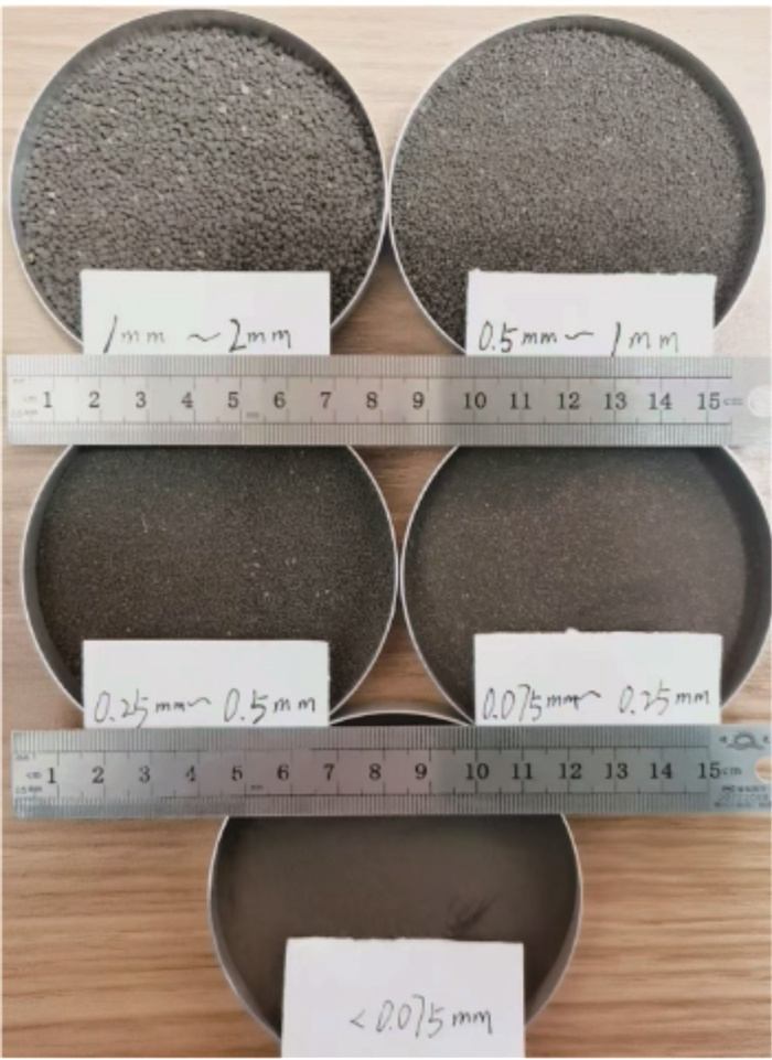
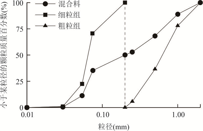
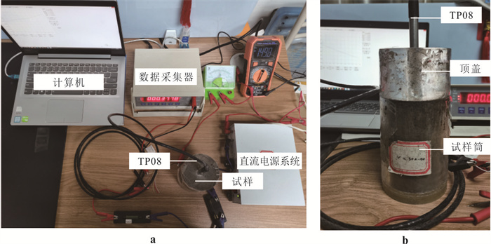
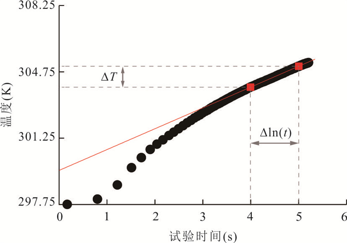
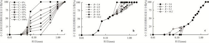
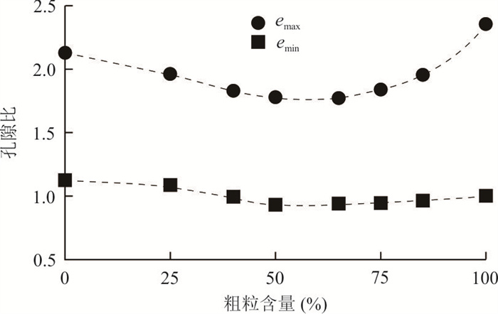
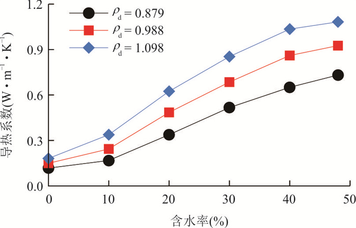
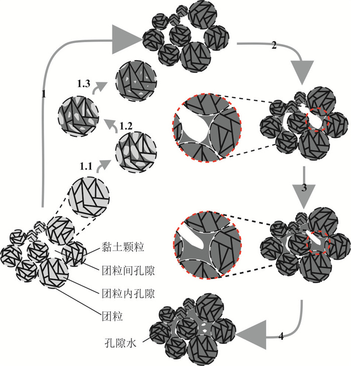
2025, 50(4): 1625-1637.
doi: 10.3799/dqkx.2024.038
Abstract:
To understand the evolution of landslide susceptibility in reservoir areas, in this research it focuses on multi-temporal landslides in the Wanzhou district of the Three Gorges Reservoir area. The spatial distribution of landslides and their temporal variations were analyzed using the frequency ratio method. Machine learning algorithms are employed to construct landslide susceptibility models for different time sequences, investigating the models' temporal effectiveness and the evolution of susceptibility. The distribution trends of areas with high susceptibility in various time sequences are depicted using standard deviation ellipses. Results show that the impact of different predisposing factors on landslides changes over time. As the time span of landslide inventory data increases, the accuracy of the susceptibility models decreases. Models based on chronologically ordered data have high modeling accuracy but low predictive precision, and their predictive performance diminishes over time. The standard deviation ellipses for high-susceptibility areas differ significantly across time sequences and correlate with human engineering activities. The study highlights the temporal variability and evolving patterns of landslide susceptibility, underscoring the need for future landslide susceptibility assessments to consider the temporal aspect of landslide development.
To understand the evolution of landslide susceptibility in reservoir areas, in this research it focuses on multi-temporal landslides in the Wanzhou district of the Three Gorges Reservoir area. The spatial distribution of landslides and their temporal variations were analyzed using the frequency ratio method. Machine learning algorithms are employed to construct landslide susceptibility models for different time sequences, investigating the models' temporal effectiveness and the evolution of susceptibility. The distribution trends of areas with high susceptibility in various time sequences are depicted using standard deviation ellipses. Results show that the impact of different predisposing factors on landslides changes over time. As the time span of landslide inventory data increases, the accuracy of the susceptibility models decreases. Models based on chronologically ordered data have high modeling accuracy but low predictive precision, and their predictive performance diminishes over time. The standard deviation ellipses for high-susceptibility areas differ significantly across time sequences and correlate with human engineering activities. The study highlights the temporal variability and evolving patterns of landslide susceptibility, underscoring the need for future landslide susceptibility assessments to consider the temporal aspect of landslide development.
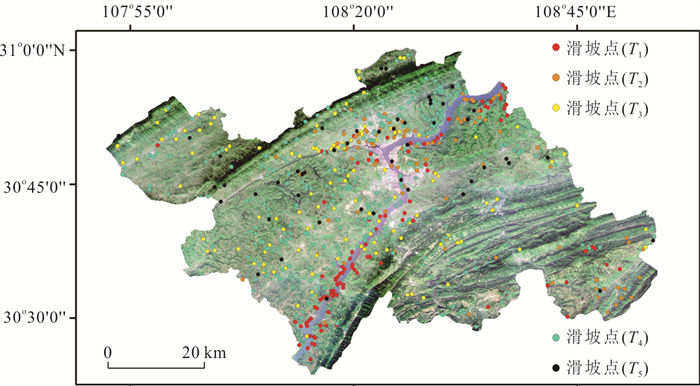
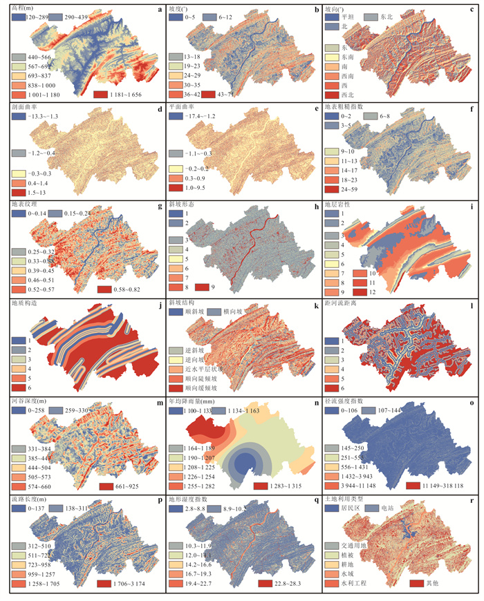
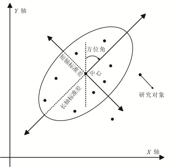
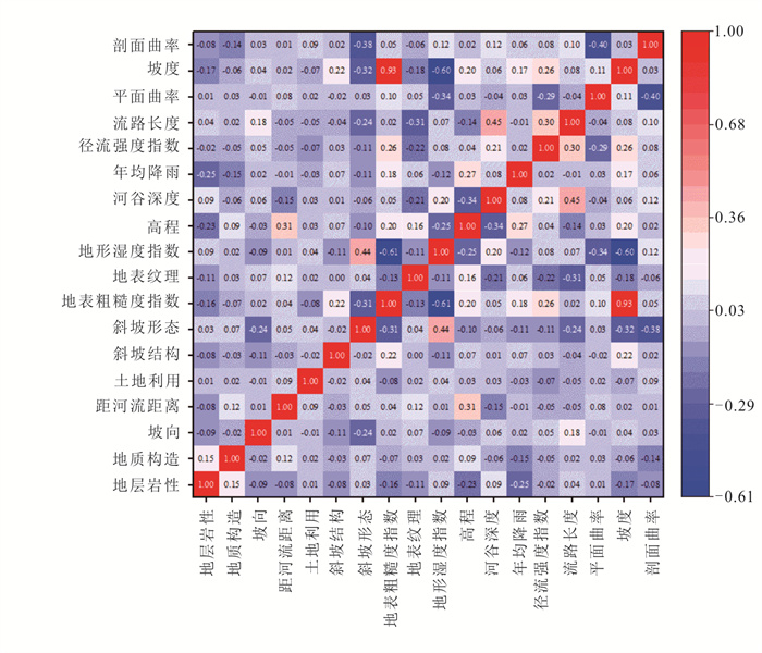
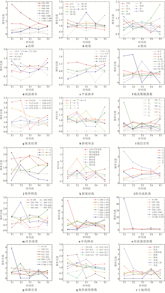
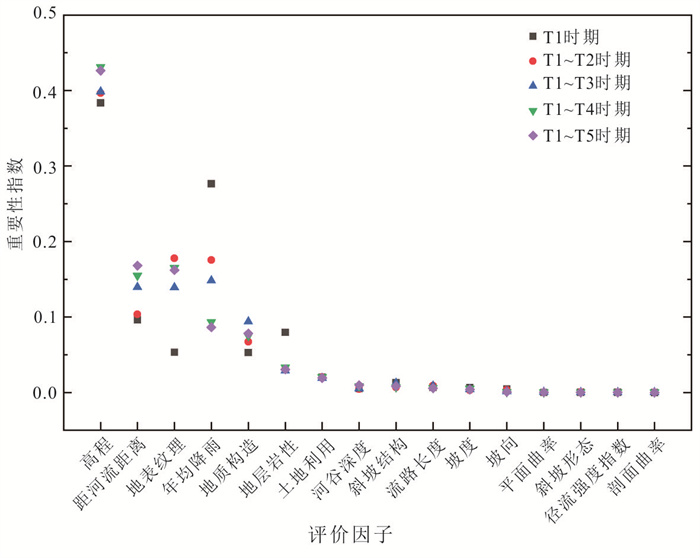
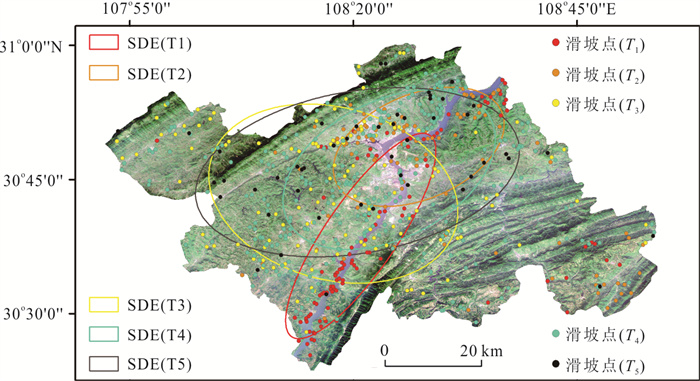
2025, 50(4): 1638-1650.
doi: 10.3799/dqkx.2024.049
Abstract:
To study the distribution characteristics of microbial communities in magma-heated high-temperature hot springs and their response to environmental changes, fourteen samples were collected from three hot springs (HMZ, LP01 and QQ) and their flow paths in Tengchong, Yunnan Province. The physical and chemical parameters and amplicon sequencing for 16S rRNA genes were measured, and the relationship between microbial communities and environmental factors was elucidated. The three hot springs had different dominant taxa at genus level: Thermus, Hydrogenobacter, Caldimicrobium, and Fervidobacterium in HMZ and its flow path, Candidatus_Caldiarchaeum, Ignavibacterium, and Thermodesulfovibrio in LP01 and its flow path, and Candidatus_Nitrosocaldus, Chloroflexus, Meiothermus, Ralstonia, and Gemmata in QQ and its flow path. The canonical correspondence analysis results show that the basic physical and chemical parameters (i.e., temperature and sulfide), major elements (i.e., Mg, Ca, and K), and trace elements (i.e., W, Al, Ba, Rb, Li, and Cs) of hot springs were the controlling factors for the microbial communities (P < 0.05). The variance partitioning analysis further demonstrated their interpretational proportions by 21.07%, 6.69%, and 6.24%, respectively with a co-interpretational proportion by 7.32% and a total proportion of environmental factors by 41.32%. The hydrochemical parameters of magma-heated high-temperature hot springs in Tengchong have promoted the succession of dominant microbial taxa to some extent.
To study the distribution characteristics of microbial communities in magma-heated high-temperature hot springs and their response to environmental changes, fourteen samples were collected from three hot springs (HMZ, LP01 and QQ) and their flow paths in Tengchong, Yunnan Province. The physical and chemical parameters and amplicon sequencing for 16S rRNA genes were measured, and the relationship between microbial communities and environmental factors was elucidated. The three hot springs had different dominant taxa at genus level: Thermus, Hydrogenobacter, Caldimicrobium, and Fervidobacterium in HMZ and its flow path, Candidatus_Caldiarchaeum, Ignavibacterium, and Thermodesulfovibrio in LP01 and its flow path, and Candidatus_Nitrosocaldus, Chloroflexus, Meiothermus, Ralstonia, and Gemmata in QQ and its flow path. The canonical correspondence analysis results show that the basic physical and chemical parameters (i.e., temperature and sulfide), major elements (i.e., Mg, Ca, and K), and trace elements (i.e., W, Al, Ba, Rb, Li, and Cs) of hot springs were the controlling factors for the microbial communities (P < 0.05). The variance partitioning analysis further demonstrated their interpretational proportions by 21.07%, 6.69%, and 6.24%, respectively with a co-interpretational proportion by 7.32% and a total proportion of environmental factors by 41.32%. The hydrochemical parameters of magma-heated high-temperature hot springs in Tengchong have promoted the succession of dominant microbial taxa to some extent.
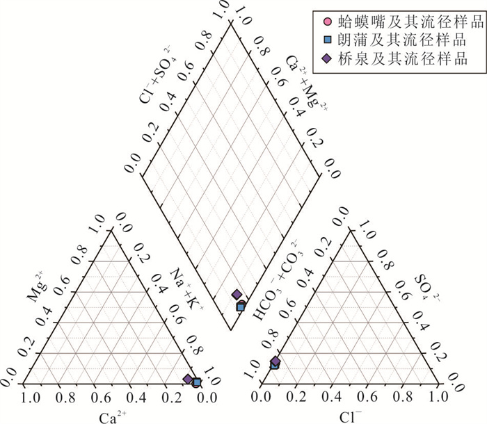
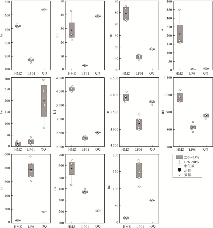
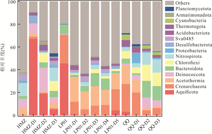
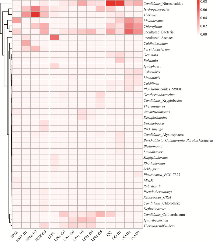
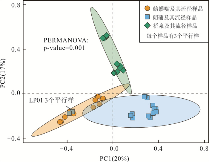
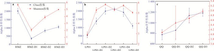
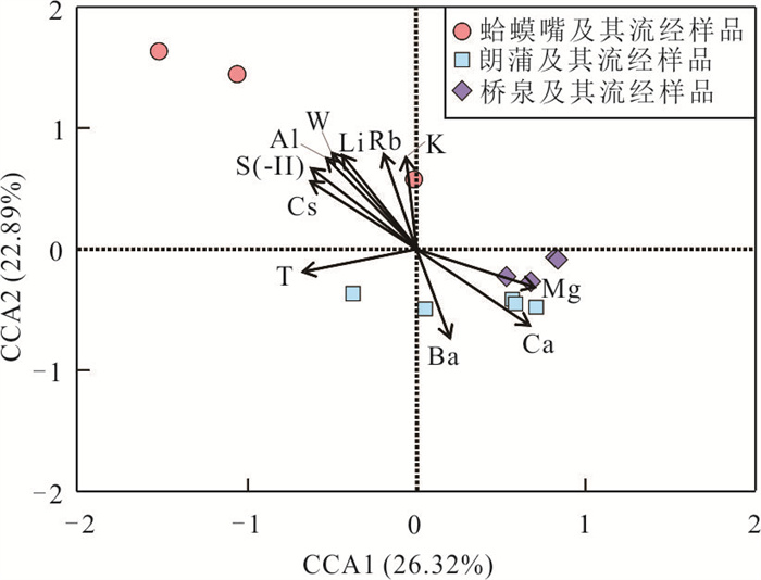
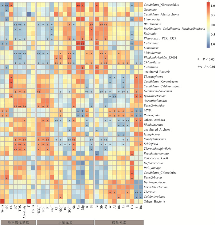
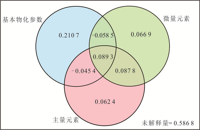
2025, 50(4): 1651-1662.
doi: 10.3799/dqkx.2024.069
Abstract:
In order to study the ecological stoichiometric characteristics and influencing factors of carbon (C), nitrogen (N), phosphorus (P) in sediments of the hyporheic zone within the lake wetland, 4 monitoring transections and 16 boreholes were set up in the wetland at the entrance of the Xiangjiang River in South Dongting Lake. A total of 156 sediment samples were collected for parameter testing within a depth range of 0-10 m. Correlation analysis, redundancy analysis and structural equation modeling were applied in the investigation. The results indicate that the average contents of total carbon (TC), organic carbon (SOC), total nitrogen (TN), and total phosphorus (TP) in sediment are 8.99, 7.30, 0.93, and 0.46 g/kg, respectively, which show a decreasing trend with increasing sampling depth (H). The average ratios of C/N, C/P, and N/P in sediments are 10.46, 46.51, and 5.06, respectively, with strong spatial variability. The lower C/N and C/P indicate that organic N and organic P are prone to mineralization, while lower N/P indicates that sediments are mainly limited by N. TC, SOC, TN and TP contents have a significant negative correlation with H and redox potential (Eh), and a significant positive correlation with water content (ω). H, Eh and ω are the main driving factors influencing C, N and P contents and their ecological stoichiometric characteristics in wetland sediments.
In order to study the ecological stoichiometric characteristics and influencing factors of carbon (C), nitrogen (N), phosphorus (P) in sediments of the hyporheic zone within the lake wetland, 4 monitoring transections and 16 boreholes were set up in the wetland at the entrance of the Xiangjiang River in South Dongting Lake. A total of 156 sediment samples were collected for parameter testing within a depth range of 0-10 m. Correlation analysis, redundancy analysis and structural equation modeling were applied in the investigation. The results indicate that the average contents of total carbon (TC), organic carbon (SOC), total nitrogen (TN), and total phosphorus (TP) in sediment are 8.99, 7.30, 0.93, and 0.46 g/kg, respectively, which show a decreasing trend with increasing sampling depth (H). The average ratios of C/N, C/P, and N/P in sediments are 10.46, 46.51, and 5.06, respectively, with strong spatial variability. The lower C/N and C/P indicate that organic N and organic P are prone to mineralization, while lower N/P indicates that sediments are mainly limited by N. TC, SOC, TN and TP contents have a significant negative correlation with H and redox potential (Eh), and a significant positive correlation with water content (ω). H, Eh and ω are the main driving factors influencing C, N and P contents and their ecological stoichiometric characteristics in wetland sediments.
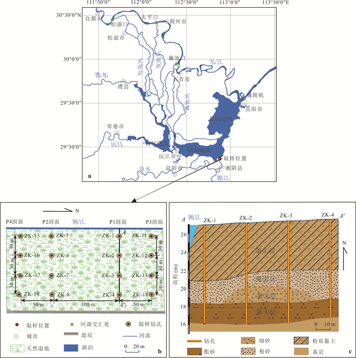
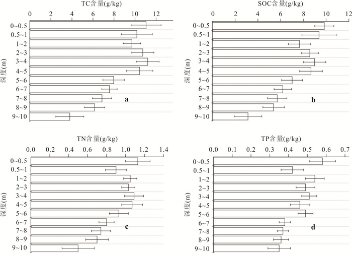
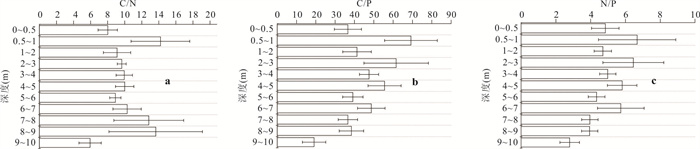
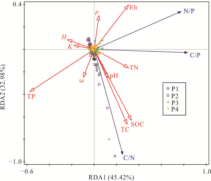
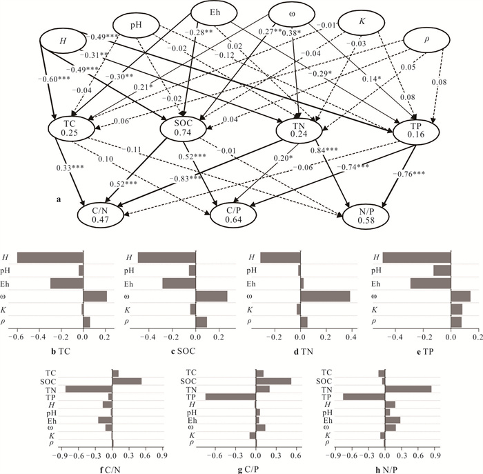
2025, 50(4): 1663-1672.
doi: 10.3799/dqkx.2024.046
Abstract:
Studying the interannual fluctuations during the rise of Global Mean Sea Level (GMSL) helps us to gain a deeper understanding of the changes in GMSL. This work mainly studies the two significant interannual fluctuations and their causes experienced by GMSL between 2005 and 2016, quantitatively estimates the spital distribution and contribution of terrestrial water storage (TWS) anomaly to GMSL changes in different global continent and analyzes the correlation between abnormal TWS changes in different continents and El Niño southern oscillation (ENSO). The results show that in the interannual fluctuations of GMSL, the contribution of gravity sea level (BSL) changes related to oceanic mass changes is 80%, and the contribution of steric sea level changes related to changes in seawater temperature and salinity is about 20%. The melting of ice sheets in Greenland and Antarctica mainly affects the long-term trend of BSL. TWS anomaly change in different continents affects the interannual changes of BSL differently, with South America contributing the most, followed by North America, Asia, and Oceania, the TWS contribution from Europe is the smallest. The correlation between TWS anomaly change in South America and ENSO is the strongest, with a correlation coefficient of -0.76 and a phase lead of 7 months. The correlation is the weakest in North America, reaching its maximum value of -0.25 at a phase lead of 5 months.
Studying the interannual fluctuations during the rise of Global Mean Sea Level (GMSL) helps us to gain a deeper understanding of the changes in GMSL. This work mainly studies the two significant interannual fluctuations and their causes experienced by GMSL between 2005 and 2016, quantitatively estimates the spital distribution and contribution of terrestrial water storage (TWS) anomaly to GMSL changes in different global continent and analyzes the correlation between abnormal TWS changes in different continents and El Niño southern oscillation (ENSO). The results show that in the interannual fluctuations of GMSL, the contribution of gravity sea level (BSL) changes related to oceanic mass changes is 80%, and the contribution of steric sea level changes related to changes in seawater temperature and salinity is about 20%. The melting of ice sheets in Greenland and Antarctica mainly affects the long-term trend of BSL. TWS anomaly change in different continents affects the interannual changes of BSL differently, with South America contributing the most, followed by North America, Asia, and Oceania, the TWS contribution from Europe is the smallest. The correlation between TWS anomaly change in South America and ENSO is the strongest, with a correlation coefficient of -0.76 and a phase lead of 7 months. The correlation is the weakest in North America, reaching its maximum value of -0.25 at a phase lead of 5 months.