2024 Vol. 49, No. 8
Display Method:
2024, 49(8): 2685-2696.
doi: 10.3799/dqkx.2023.027
 PDF 13855KB
Abstract:
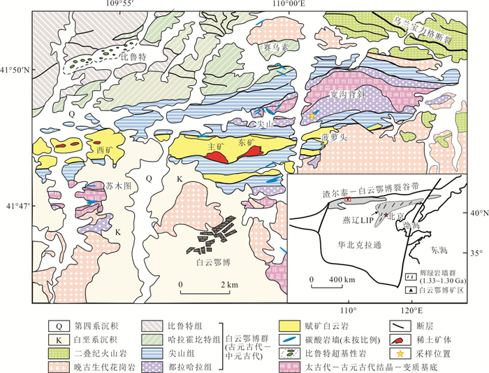
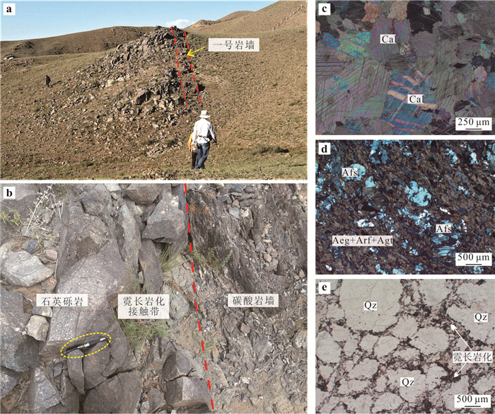
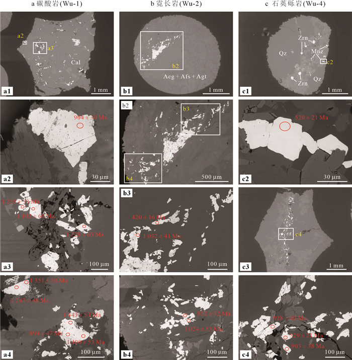
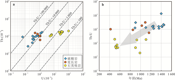
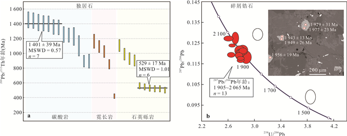
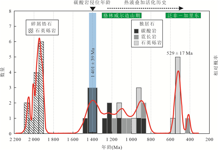
Growing evidence suggests that mineralisation of the world-renowned Bayan Obo REE deposit is genetically linked to the intrusion of carbonatite dykes in Archean-Paleoproterozoic sedimentary rocks. Hence, accurate determination of the emplacement age of the carbonatite dykes is critically important for understanding the genesis and geodynamic drivers of the giant REE deposits. Dating carbonatites has proven challenging because they are commonly overprinted by later tectono-thermal events. Previous attempts to date the Bayan Obo carbonatites have yielded younger ages reflecting post-magmatic overprinting (typically 1 300 – 420 Ma). In this study, we collected samples from the No. 1 carbonatite dyke (Wu dyke) and its fenitised wall-rocks and carried out insitu (in polished thin section) U-Th-Pb dating of monazite by Sensitive High-Resolution Ion Microprobe (SHRIMP), which enables us to precisely reconstruct the magmatic and hydrothermal history of the dyke. Monazites in the calcite carbonatite, fenite and metasomatised quartz conglomerate are characterised by extreme depletion of U and high Th/U ratios. The oldest cluster of monazite analyses yielded a weighted mean 208Pb/232Th age of 1 401±39 Ma (MSWD=0.57, n=7), which is the oldest monazite age hitherto obtained from Bayan Obo, and is taken to approximate the onset of intrusion of the carbonatite dykes. This age confirms that the carbonatite magmatism at Bayan Obo predates the 1.33-1.30 Ga Yanliao Large Igneous Province, but coincides with the separation of North China Craton from the Western Australian Craton as part of the greater breakup of the Nuna/Columbia supercontinent (1 450-1 380 Ma). Our results also reveal repeated monazite growth during the late Mesoproterozoic through to the early Paleozoic (1 300-420 Ma) as widely documented in previous studies. Notably, our data define a prominent age peak at 529±17 Ma (MSWD=1.01, n=6) indicating Pan-African overprinting, supportive of recent reconstruction placing North China at the northern margin of Gondwana during the earliest Paleozoic. In addition, zircon crystals in the quartz conglomerate were also analysed in this study and yielded concordant 207Pb/206Pb dates between 2.1 Ga and 1.9 Ga, which are interpreted as detrital ages on the basis of crystal morphology and Th-U chemistry of the zircon. In summary, the new monazite geochronology data from the Wu dyke significantly refine the magmatic-hydrothermal timeframe of the Bayan Obo carbonatites, affording new insights into the geodynamic drivers and genesis of the giant REE deposits.
Growing evidence suggests that mineralisation of the world-renowned Bayan Obo REE deposit is genetically linked to the intrusion of carbonatite dykes in Archean-Paleoproterozoic sedimentary rocks. Hence, accurate determination of the emplacement age of the carbonatite dykes is critically important for understanding the genesis and geodynamic drivers of the giant REE deposits. Dating carbonatites has proven challenging because they are commonly overprinted by later tectono-thermal events. Previous attempts to date the Bayan Obo carbonatites have yielded younger ages reflecting post-magmatic overprinting (typically 1 300 – 420 Ma). In this study, we collected samples from the No. 1 carbonatite dyke (Wu dyke) and its fenitised wall-rocks and carried out insitu (in polished thin section) U-Th-Pb dating of monazite by Sensitive High-Resolution Ion Microprobe (SHRIMP), which enables us to precisely reconstruct the magmatic and hydrothermal history of the dyke. Monazites in the calcite carbonatite, fenite and metasomatised quartz conglomerate are characterised by extreme depletion of U and high Th/U ratios. The oldest cluster of monazite analyses yielded a weighted mean 208Pb/232Th age of 1 401±39 Ma (MSWD=0.57, n=7), which is the oldest monazite age hitherto obtained from Bayan Obo, and is taken to approximate the onset of intrusion of the carbonatite dykes. This age confirms that the carbonatite magmatism at Bayan Obo predates the 1.33-1.30 Ga Yanliao Large Igneous Province, but coincides with the separation of North China Craton from the Western Australian Craton as part of the greater breakup of the Nuna/Columbia supercontinent (1 450-1 380 Ma). Our results also reveal repeated monazite growth during the late Mesoproterozoic through to the early Paleozoic (1 300-420 Ma) as widely documented in previous studies. Notably, our data define a prominent age peak at 529±17 Ma (MSWD=1.01, n=6) indicating Pan-African overprinting, supportive of recent reconstruction placing North China at the northern margin of Gondwana during the earliest Paleozoic. In addition, zircon crystals in the quartz conglomerate were also analysed in this study and yielded concordant 207Pb/206Pb dates between 2.1 Ga and 1.9 Ga, which are interpreted as detrital ages on the basis of crystal morphology and Th-U chemistry of the zircon. In summary, the new monazite geochronology data from the Wu dyke significantly refine the magmatic-hydrothermal timeframe of the Bayan Obo carbonatites, affording new insights into the geodynamic drivers and genesis of the giant REE deposits.
2024, 49(8): 2697-2713.
doi: 10.3799/dqkx.2023.064
Abstract:
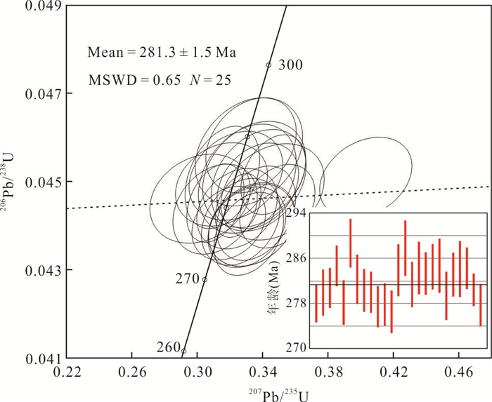
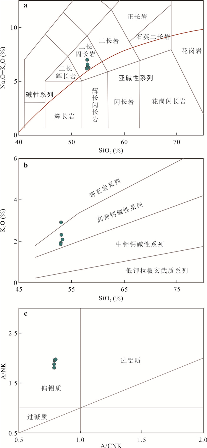
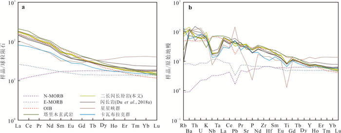
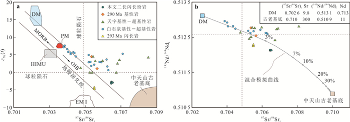
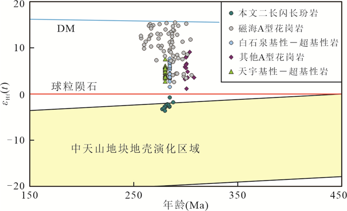
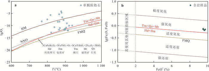
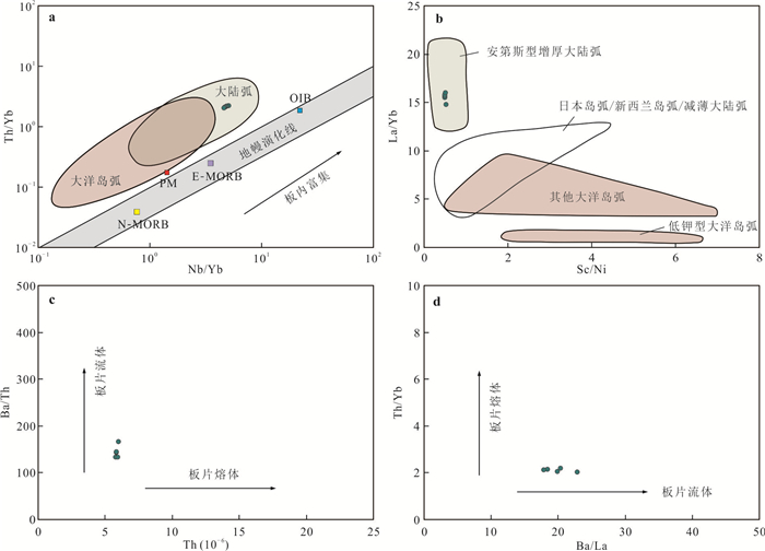
As a typical case of the Permian magmatism in the Eastern Tianshan, the porphyritic monzodiorite exposed in the southern margin of the Central Tianshan block. Zircon U-Pb dating on the monzodiorite yields an age of 281.3±1.5 Ma. The monzodiorite shows high-K calc-alkaline and metaluminous affinities, with Na2O+K2O and A/CNK values ranging 5.88‒6.62 wt.% and 0.66‒0.73, respectively. They are characterized by high Fe2O3/FeO ratios (0.66~0.73), and present the assemblage of titanite+quartz+magnetite in the groundmass, suggesting that the monzodiorite formed under a high oxygen fugacity condition. The monzodiorite enriched in LILEs (i.e. Rb, K and Ba), but depleted in HFSEs (i.e. Nb, Ta and Ti) and HREE. In addition, all the study samples have negative εNd(t) (-2.72 to -3.07), high initial 87Sr/86Sr (0.706 46 to 0.706 54) values, and negative zircon εHf(t) (-3.7 to -0.8) values, as well as intermediate Nb/U (10.3 to 10.9) values. These geochemical features indicating that the magmas originated from spinel-garnet lherzolite that metasomatized by subduction-related fluids, and mixed with minor crustal components. Integrating the petrogenesis and other geological evidences, we proposed that the magmatisms in the Central Tianshan block were generated in post-collision extensional setting of slab breakoff during the Early Permian.
As a typical case of the Permian magmatism in the Eastern Tianshan, the porphyritic monzodiorite exposed in the southern margin of the Central Tianshan block. Zircon U-Pb dating on the monzodiorite yields an age of 281.3±1.5 Ma. The monzodiorite shows high-K calc-alkaline and metaluminous affinities, with Na2O+K2O and A/CNK values ranging 5.88‒6.62 wt.% and 0.66‒0.73, respectively. They are characterized by high Fe2O3/FeO ratios (0.66~0.73), and present the assemblage of titanite+quartz+magnetite in the groundmass, suggesting that the monzodiorite formed under a high oxygen fugacity condition. The monzodiorite enriched in LILEs (i.e. Rb, K and Ba), but depleted in HFSEs (i.e. Nb, Ta and Ti) and HREE. In addition, all the study samples have negative εNd(t) (-2.72 to -3.07), high initial 87Sr/86Sr (0.706 46 to 0.706 54) values, and negative zircon εHf(t) (-3.7 to -0.8) values, as well as intermediate Nb/U (10.3 to 10.9) values. These geochemical features indicating that the magmas originated from spinel-garnet lherzolite that metasomatized by subduction-related fluids, and mixed with minor crustal components. Integrating the petrogenesis and other geological evidences, we proposed that the magmatisms in the Central Tianshan block were generated in post-collision extensional setting of slab breakoff during the Early Permian.

2024, 49(8): 2714-2735.
doi: 10.3799/dqkx.2020.320
Abstract:
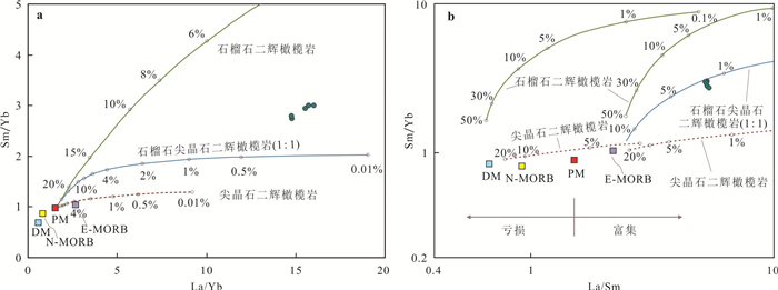
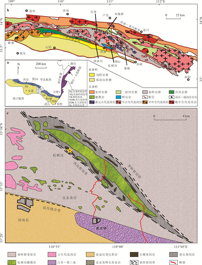
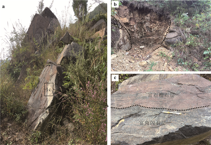
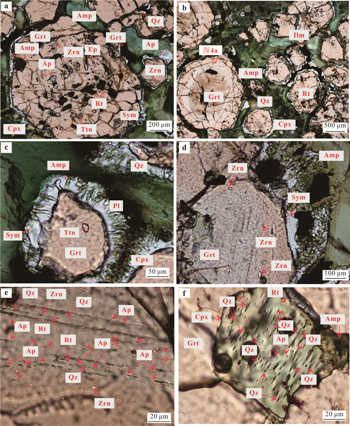
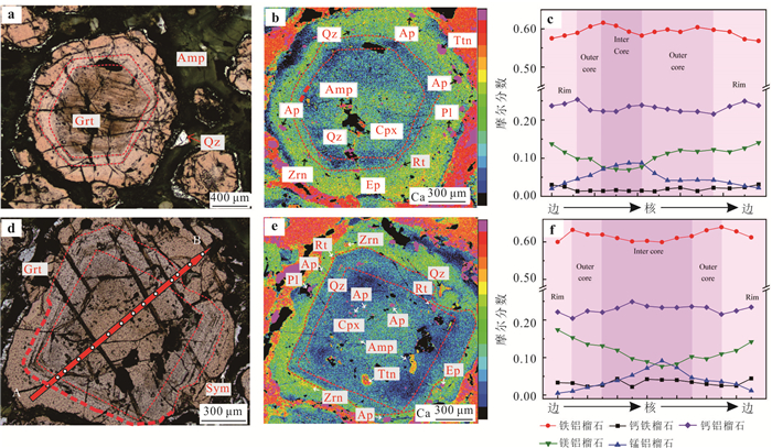
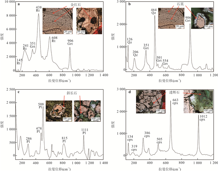
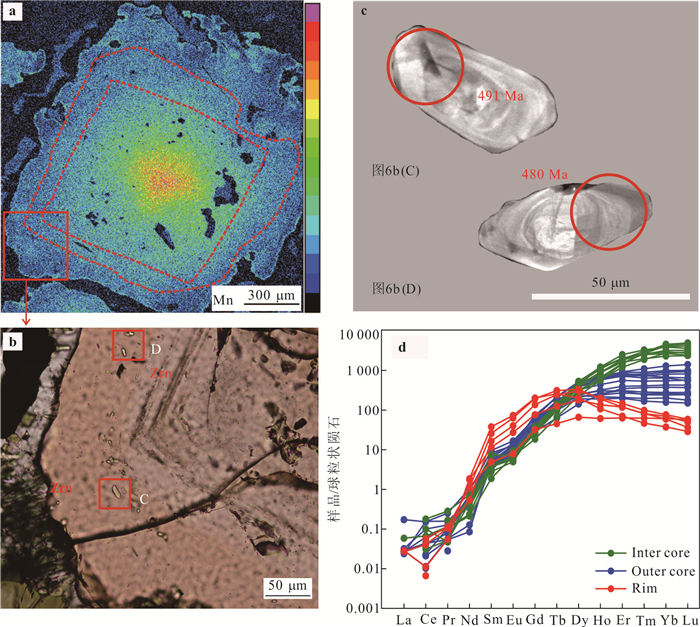
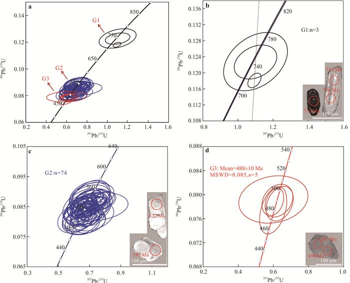
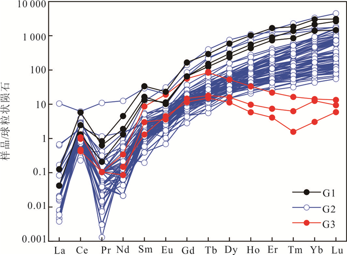
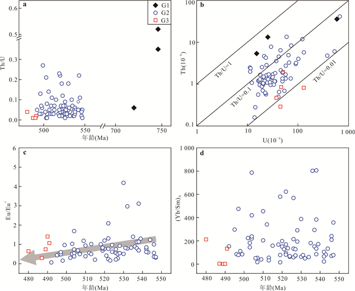
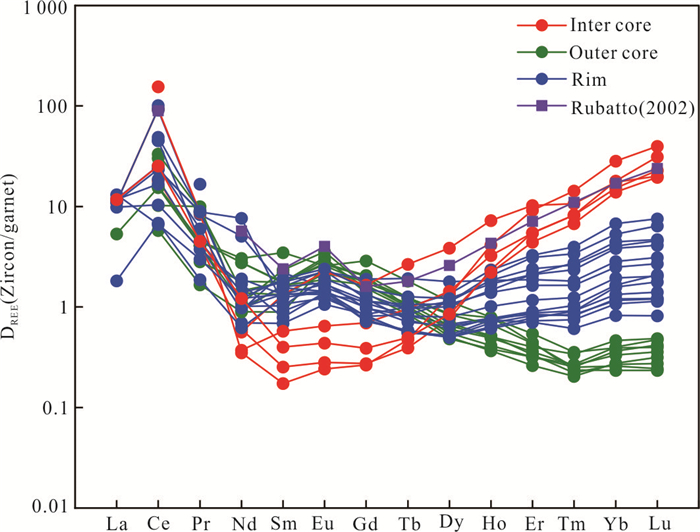
The metamorphic evolution and tectonic framework of the North Qinling orogen in the Early Paleozoic has long been controversial and is one of the widely concerned geological problems. Although much isotopic work has been done, the timing of peak eclogite-facies metamorphism is still debatable. Therefore, an intergrated study of garnet geochemistry and zircon geochronology was carried out for garnet amphibolite from Songshugou Complex in the North Qinling orogen. Based on the characristics of the petrographic microstructures, mineral inclusions, and mineral compositions, three metamorphic stages are recognized for mineral assemblages in the garnet amphibolite: prograde stage (522-611 ℃/1.4-3.0 kbar), peak stage (742-749 ℃/ > 3.0 GPa) and retrograde stage (726-764 ℃/7.3-8.3 kbar). Geochronology study reveals that zircon grains in thin sections and mounts record three episodes of growth or reworking, respectively: (1) relict magmatic cores (G1), showing typical oscillatory zoning with middle Neoprotrozoic U-Pb ages of 746±16 Ma to 720±7 Ma and steep HREE patterns with obvious negative Eu anomalies, indicating the protolith of garnet amphibolite was produced in the Neoproterozoic; (2) metamorphically recrystallized domains (G2), exhibiting faintish oscillatory zoning or unzoning with discordant U-Pb ages ranging from 547±17 Ma to 492±15 Ma and steep HREE patterns with positive to negative Eu anomalies; (3) metamorphically grown domains (G3), which occur not only as overgrown rim in mounts but also as mineral inclusion within garnet rims in thin sections. They gave consistent 206Pb/238U age of 491 Ma to 480 Ma(average age is 488±10 Ma), flat HREE patterns with low Th/U ratios of 0.01 to 0.04, high MREE contents and no obvious Eu anomalies, indicating the timing of peak eclogite-facies metamorphism. In addition, the rod-like exsolution composed of rutile + apatite +quartzis identified in the garnet rim that formed at the peak metamorphic stage from the garnet amphibolite, indicating that it might have ever underwent ultra-high pressure metamorphism. Therefore, the garnet amphibolite has its protolith from the North Qinling microcontinent that was separated from Rodinia supercontinent between 746 Ma and 720 Ma. It was deeply subductedfor metamorphism in the Cambrian toachieve the peak eclogite-facies metamorphismat 488 Ma, and then underwent exhumation for the retrograde amphibolite facies metamorphism.
The metamorphic evolution and tectonic framework of the North Qinling orogen in the Early Paleozoic has long been controversial and is one of the widely concerned geological problems. Although much isotopic work has been done, the timing of peak eclogite-facies metamorphism is still debatable. Therefore, an intergrated study of garnet geochemistry and zircon geochronology was carried out for garnet amphibolite from Songshugou Complex in the North Qinling orogen. Based on the characristics of the petrographic microstructures, mineral inclusions, and mineral compositions, three metamorphic stages are recognized for mineral assemblages in the garnet amphibolite: prograde stage (522-611 ℃/1.4-3.0 kbar), peak stage (742-749 ℃/ > 3.0 GPa) and retrograde stage (726-764 ℃/7.3-8.3 kbar). Geochronology study reveals that zircon grains in thin sections and mounts record three episodes of growth or reworking, respectively: (1) relict magmatic cores (G1), showing typical oscillatory zoning with middle Neoprotrozoic U-Pb ages of 746±16 Ma to 720±7 Ma and steep HREE patterns with obvious negative Eu anomalies, indicating the protolith of garnet amphibolite was produced in the Neoproterozoic; (2) metamorphically recrystallized domains (G2), exhibiting faintish oscillatory zoning or unzoning with discordant U-Pb ages ranging from 547±17 Ma to 492±15 Ma and steep HREE patterns with positive to negative Eu anomalies; (3) metamorphically grown domains (G3), which occur not only as overgrown rim in mounts but also as mineral inclusion within garnet rims in thin sections. They gave consistent 206Pb/238U age of 491 Ma to 480 Ma(average age is 488±10 Ma), flat HREE patterns with low Th/U ratios of 0.01 to 0.04, high MREE contents and no obvious Eu anomalies, indicating the timing of peak eclogite-facies metamorphism. In addition, the rod-like exsolution composed of rutile + apatite +quartzis identified in the garnet rim that formed at the peak metamorphic stage from the garnet amphibolite, indicating that it might have ever underwent ultra-high pressure metamorphism. Therefore, the garnet amphibolite has its protolith from the North Qinling microcontinent that was separated from Rodinia supercontinent between 746 Ma and 720 Ma. It was deeply subductedfor metamorphism in the Cambrian toachieve the peak eclogite-facies metamorphismat 488 Ma, and then underwent exhumation for the retrograde amphibolite facies metamorphism.
2024, 49(8): 2736-2750.
doi: 10.3799/dqkx.2023.033
Abstract:
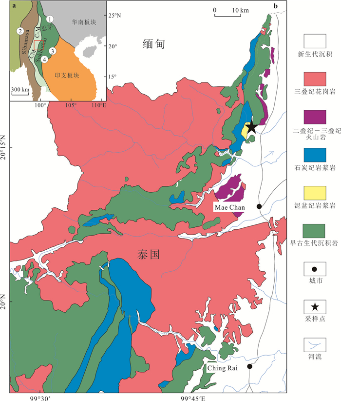
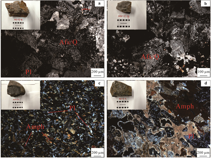
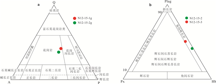
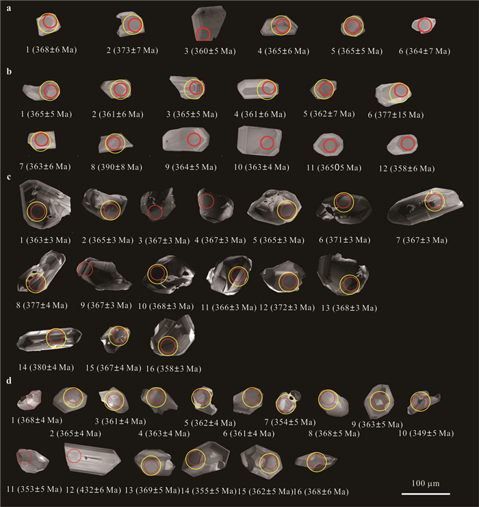
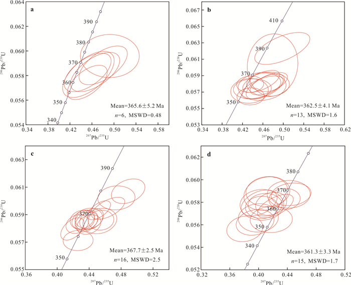
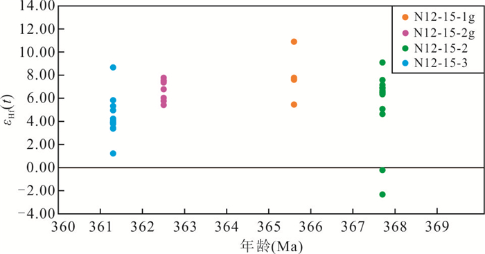
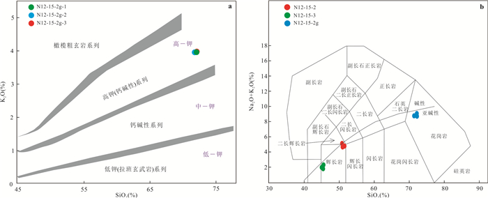
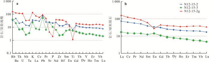
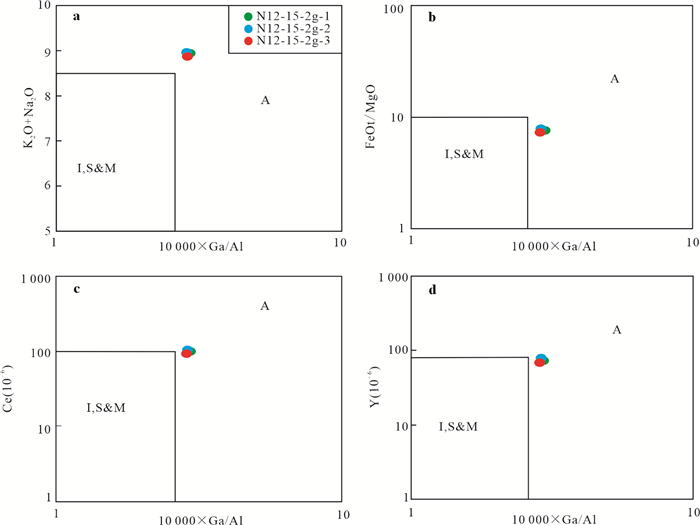
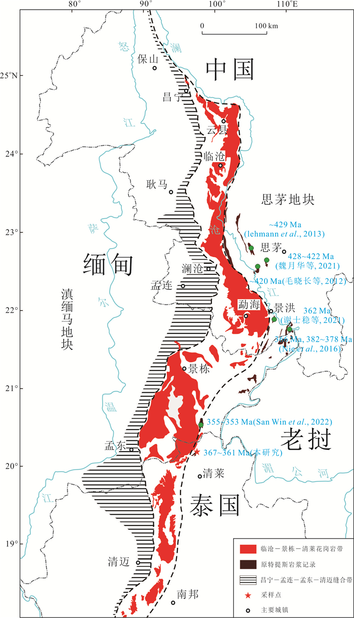
The studies of the Tethys tectonic belt in Southeast Asia mainly focus on the evolution of the Paleo-Tethys in the Late Paleozoic, while the studies of the Proto-Tethys evolution immediately are pretty weakThe present study focuses on zircon U-Pb geochronology, geochemistry and zircon Lu-Hf isotopes of granites and hornblende gabbros from northern Thailand. These magmatic rocks yielded zircon U-Pb weighted mean age of 367-361 Ma.The geologic age is the Late Devonian. The northern Thailand granites are the high-K calc-alkaline A2 type granites, with the geochemical characteristics of relatively enriched LILE and relatively depleted HFSE, with obvious negative anomalies of Nb, Ta, Sr and Ti. The Hf isotopes have positive εHf(t) values (+5.43-+10.91) with TDM2 ages of 1 015.0-668.9 Ma, indicating a juvenile mafic lower crust source.The hornblende gabbros showhigh Al2O3、Zr and Nbcontents, but low contents of TiO2 and Ni, with the geochemical characteristics ofrelatively enriched LILE and relatively depleted HFSE, with the distinctly negative Nb and Ta anomalies, similar to the characteristics of island arc calc-alkaline basalts. Positive εHf(t) values (+1.24-+9.11) and high Mg# (50.0-64.8) indicate that it originates from the depleted mantle wedge. Based on the U-Pb age, Hf isotope and geochemical characteristics of the magmatic rocks in northern Thailand, it is believed that they were formed in the Late Devonian post-collisional extension-related tectonic setting, which can be compared with the corresponding the Proto-Tethys geological records in eastern Myanmar and southwestern Yunnan. The results provide evidence for the evolution of the Proto-Tethys in southwest Yunnan and Southeast Asia.
The studies of the Tethys tectonic belt in Southeast Asia mainly focus on the evolution of the Paleo-Tethys in the Late Paleozoic, while the studies of the Proto-Tethys evolution immediately are pretty weakThe present study focuses on zircon U-Pb geochronology, geochemistry and zircon Lu-Hf isotopes of granites and hornblende gabbros from northern Thailand. These magmatic rocks yielded zircon U-Pb weighted mean age of 367-361 Ma.The geologic age is the Late Devonian. The northern Thailand granites are the high-K calc-alkaline A2 type granites, with the geochemical characteristics of relatively enriched LILE and relatively depleted HFSE, with obvious negative anomalies of Nb, Ta, Sr and Ti. The Hf isotopes have positive εHf(t) values (+5.43-+10.91) with TDM2 ages of 1 015.0-668.9 Ma, indicating a juvenile mafic lower crust source.The hornblende gabbros showhigh Al2O3、Zr and Nbcontents, but low contents of TiO2 and Ni, with the geochemical characteristics ofrelatively enriched LILE and relatively depleted HFSE, with the distinctly negative Nb and Ta anomalies, similar to the characteristics of island arc calc-alkaline basalts. Positive εHf(t) values (+1.24-+9.11) and high Mg# (50.0-64.8) indicate that it originates from the depleted mantle wedge. Based on the U-Pb age, Hf isotope and geochemical characteristics of the magmatic rocks in northern Thailand, it is believed that they were formed in the Late Devonian post-collisional extension-related tectonic setting, which can be compared with the corresponding the Proto-Tethys geological records in eastern Myanmar and southwestern Yunnan. The results provide evidence for the evolution of the Proto-Tethys in southwest Yunnan and Southeast Asia.
2024, 49(8): 2751-2765.
doi: 10.3799/dqkx.2023.066
Abstract:
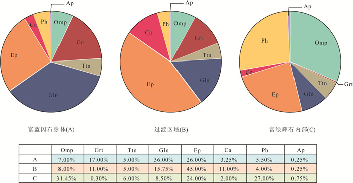
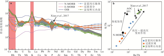
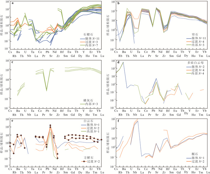
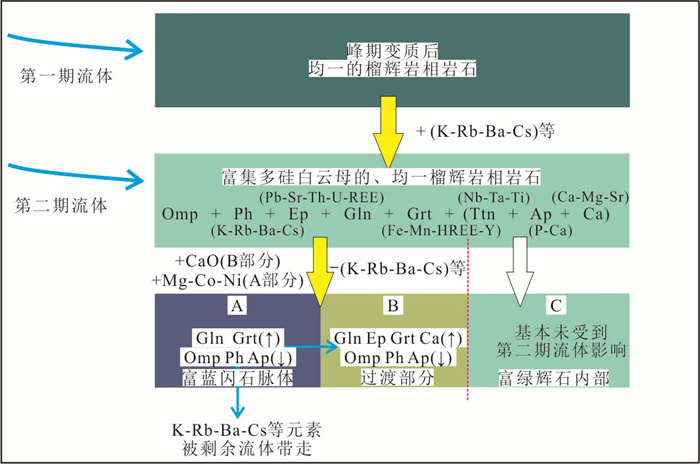
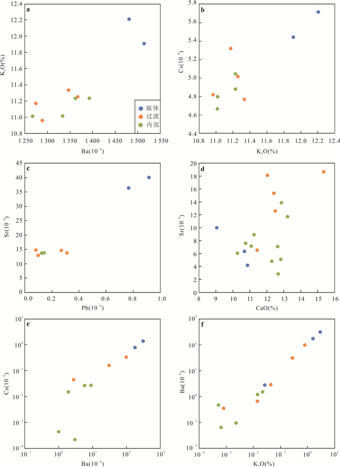
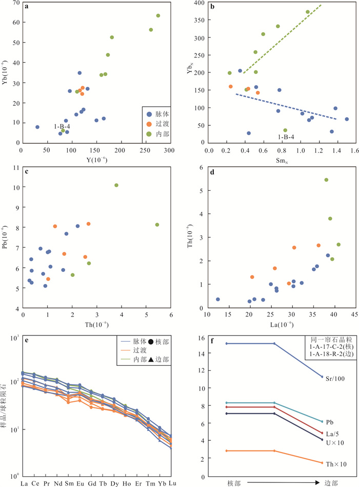
Southwestern Tianshan HP-UHP metamorphic belt developed subduction-zone metamorphic rocks affected by large-scale fluid flows, its veins and host rocks provide important informations about the infiltrating fluid in subduction zone. Based on the previous bulk-rock geochemical studies on metamorphic rocks developed veins in the subduction zone, We have conducted an in situ element study of glaucophane, garnet, omphacite, phengite and other minerals in the veins and host rocks of the metamorphic rock samples to compare the compositional differences of the same mineral in veins and host rocks. This study aims to deeply understand the differences of bulk rock compositions between veins and host rocks, and the geochemical behaviors of related elements in the fluid-rock interaction and fluid properties in subduction zones. According to the petrological characteristics, the samples can be divided into glaucophane-rich veins, epidote and carbonate-rich transitional part and the omphacite-rich interiors.The calculation of element budgets reveal that the relationship between the difference of bulk-rock compositions and host minerals and their abundances. The higher contents of medium-heavy rare earth element (M-HREE) in veins reflects the occurrence of M-HREE by more garnets in veins; and the higher contents of rare earth elements-Th-U-Pb-Sr in the transitional part reflects a large number of epidote group minerals and carbonates controlthese elements; the higher contents of K-Rb-Ba-Cs in omphacite-rich interiors reflects the control of these elements by phengite. On the other hand, the compositional differences of the same mineral in different parts of the rock samples can reflect the geochemical changes of elements in different metamorphic stages and different rehydration degrees directly.Compared with the omphacite-rich interior representing the least fluidinfiltration, the rehydration of external fluid decreased the abundances of phengite and omphacite in the veins and transitional part, and enriched K-Rb-Ba-Cs-Pb-Sr; increased abundance of garnet butdepleted HREE; increased abundance of epidote but depleted in Th-U-light rare earth elements (LREE). Combined with the large amount of carbonates in transitional part, it is speculated that the external fluid is carbonate-bearing serpentinite-derived fluid. After the fluid- rock interaction, the contents of LILE increased and the carbonate component of the fluid decreased significantly in fluid, but the contents of other elements show less variation.
Southwestern Tianshan HP-UHP metamorphic belt developed subduction-zone metamorphic rocks affected by large-scale fluid flows, its veins and host rocks provide important informations about the infiltrating fluid in subduction zone. Based on the previous bulk-rock geochemical studies on metamorphic rocks developed veins in the subduction zone, We have conducted an in situ element study of glaucophane, garnet, omphacite, phengite and other minerals in the veins and host rocks of the metamorphic rock samples to compare the compositional differences of the same mineral in veins and host rocks. This study aims to deeply understand the differences of bulk rock compositions between veins and host rocks, and the geochemical behaviors of related elements in the fluid-rock interaction and fluid properties in subduction zones. According to the petrological characteristics, the samples can be divided into glaucophane-rich veins, epidote and carbonate-rich transitional part and the omphacite-rich interiors.The calculation of element budgets reveal that the relationship between the difference of bulk-rock compositions and host minerals and their abundances. The higher contents of medium-heavy rare earth element (M-HREE) in veins reflects the occurrence of M-HREE by more garnets in veins; and the higher contents of rare earth elements-Th-U-Pb-Sr in the transitional part reflects a large number of epidote group minerals and carbonates controlthese elements; the higher contents of K-Rb-Ba-Cs in omphacite-rich interiors reflects the control of these elements by phengite. On the other hand, the compositional differences of the same mineral in different parts of the rock samples can reflect the geochemical changes of elements in different metamorphic stages and different rehydration degrees directly.Compared with the omphacite-rich interior representing the least fluidinfiltration, the rehydration of external fluid decreased the abundances of phengite and omphacite in the veins and transitional part, and enriched K-Rb-Ba-Cs-Pb-Sr; increased abundance of garnet butdepleted HREE; increased abundance of epidote but depleted in Th-U-light rare earth elements (LREE). Combined with the large amount of carbonates in transitional part, it is speculated that the external fluid is carbonate-bearing serpentinite-derived fluid. After the fluid- rock interaction, the contents of LILE increased and the carbonate component of the fluid decreased significantly in fluid, but the contents of other elements show less variation.

2024, 49(8): 2766-2788.
doi: 10.3799/dqkx.2024.023
Abstract:
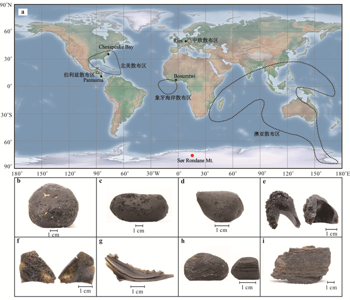
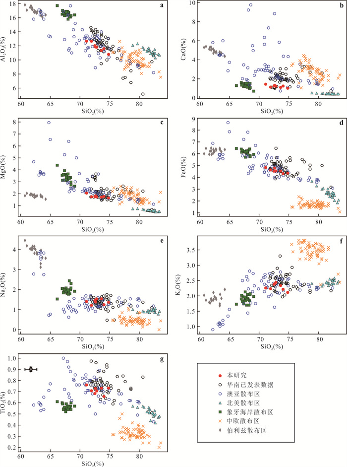
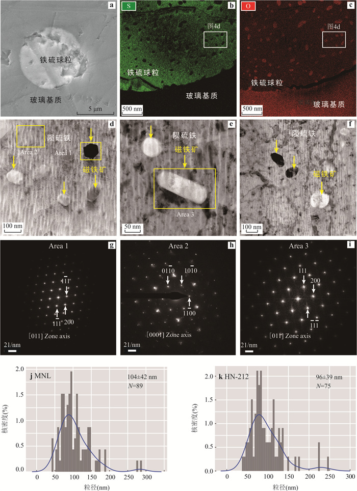
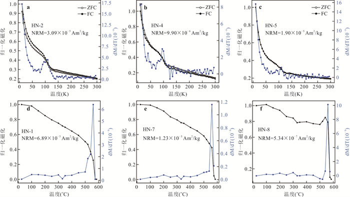
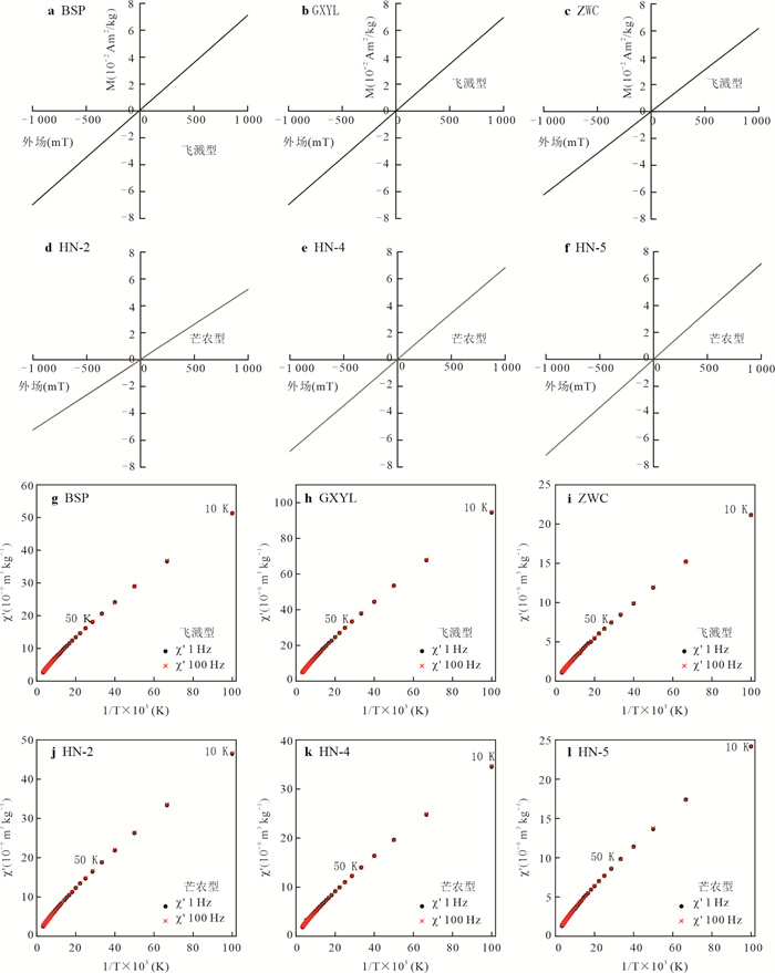
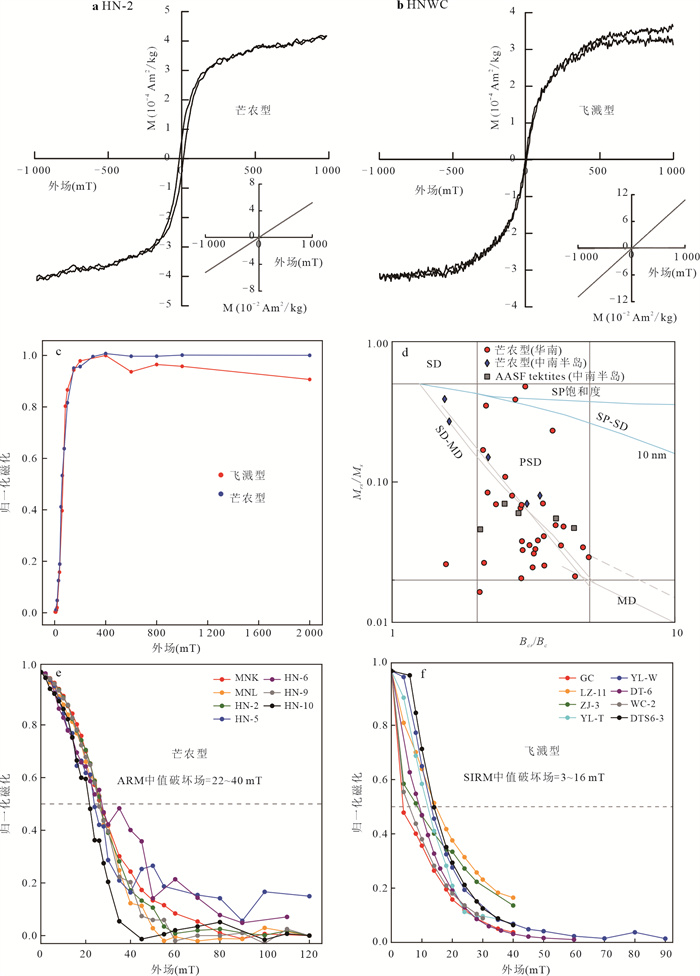
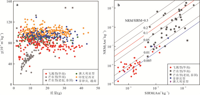
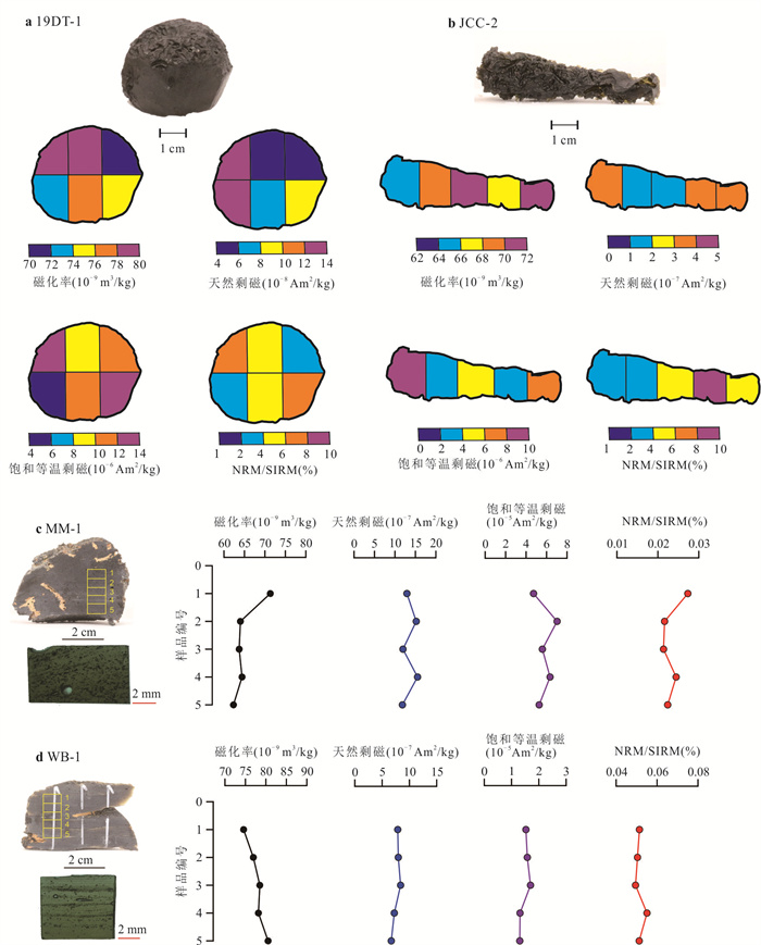
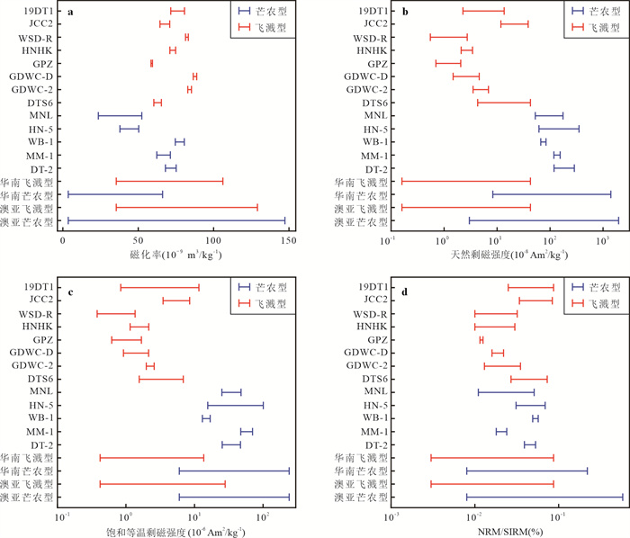
Hypervelocity impact of extra-terrestrial materials is one of the key controlling factors in the evolution of the Earth system. Impact cratering produces wide spread vaporized, molten and shock metamorphic materials. Tektites, part of distal impact ejecta that are located at more than five radii of the source crater, are quenched from vaporized and molten materials during flight. Tektites are faithful recorders of extreme high-temperature and high-pressure environments, and their magnetic signatures are key information for decoding impact cratering process. The Australasian strewn field (AASF) is the largest (~1×10⁸ km2) and youngest (788, 000 years ago) Cenozoic strewn field of tektites and microtektites on Earth, but its source crater is undiscovered yet. AASF tektites formed in an oblique impact from north to south, and the majority of AASF tektites are distributed in the downrange area, i.e., the Indochina Peninsula-Australia-Antarctica and their adjacent areas. South China is part of the uprange area of this strewn field and tektites from this area are insufficiently studied compared to those from the rest of the strewn field. Here, we present rock magnetism study of AASF tektites from Guangdong, Guangxi, and Hainan Provinces. The results show that AASF tektites from South China are dominated by significant paramagnetic signals, and weak ferromagnetic signals are detected. In the entire strewn field, splash-form tektites from South China exhibit the lowest natural remanent magnetization, and saturation isothermal remanent magnetization, and Muong Nong-type tektites from South China exhibit the lowest magnetic susceptibility. Crystallographic investigation of mineral inclusions reveals the presence of nanoscale magnetite particles in Muong Nong-type AASF tektites from South China, consistent with the detected signals of pseudo-single domain magnetite. This study suggests that observed heterogeneous magnetic properties are mainly caused by the different contents and sizes of magnetic particles, which can be explained by the different shock level and/or cooling history of the tektite-forming melts. Although magnetic properties of AASF tektites in different regions show large variations, individual specimens of AASF tektites from South China have relatively homogeneous magnetic properties, indicating that impact melt that formed each tektite specimen had similar compositions and experienced similar thermal history. This study demonstrates the feasibility of rock magnetic studies in untangling formation processes of AASF tektites, and it is an important reference to the search of the potential source crater.
Hypervelocity impact of extra-terrestrial materials is one of the key controlling factors in the evolution of the Earth system. Impact cratering produces wide spread vaporized, molten and shock metamorphic materials. Tektites, part of distal impact ejecta that are located at more than five radii of the source crater, are quenched from vaporized and molten materials during flight. Tektites are faithful recorders of extreme high-temperature and high-pressure environments, and their magnetic signatures are key information for decoding impact cratering process. The Australasian strewn field (AASF) is the largest (~1×10⁸ km2) and youngest (788, 000 years ago) Cenozoic strewn field of tektites and microtektites on Earth, but its source crater is undiscovered yet. AASF tektites formed in an oblique impact from north to south, and the majority of AASF tektites are distributed in the downrange area, i.e., the Indochina Peninsula-Australia-Antarctica and their adjacent areas. South China is part of the uprange area of this strewn field and tektites from this area are insufficiently studied compared to those from the rest of the strewn field. Here, we present rock magnetism study of AASF tektites from Guangdong, Guangxi, and Hainan Provinces. The results show that AASF tektites from South China are dominated by significant paramagnetic signals, and weak ferromagnetic signals are detected. In the entire strewn field, splash-form tektites from South China exhibit the lowest natural remanent magnetization, and saturation isothermal remanent magnetization, and Muong Nong-type tektites from South China exhibit the lowest magnetic susceptibility. Crystallographic investigation of mineral inclusions reveals the presence of nanoscale magnetite particles in Muong Nong-type AASF tektites from South China, consistent with the detected signals of pseudo-single domain magnetite. This study suggests that observed heterogeneous magnetic properties are mainly caused by the different contents and sizes of magnetic particles, which can be explained by the different shock level and/or cooling history of the tektite-forming melts. Although magnetic properties of AASF tektites in different regions show large variations, individual specimens of AASF tektites from South China have relatively homogeneous magnetic properties, indicating that impact melt that formed each tektite specimen had similar compositions and experienced similar thermal history. This study demonstrates the feasibility of rock magnetic studies in untangling formation processes of AASF tektites, and it is an important reference to the search of the potential source crater.
2024, 49(8): 2789-2798.
doi: 10.3799/dqkx.2023.071
Abstract:
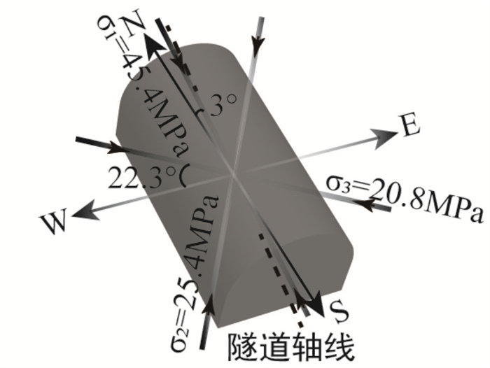
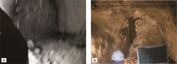
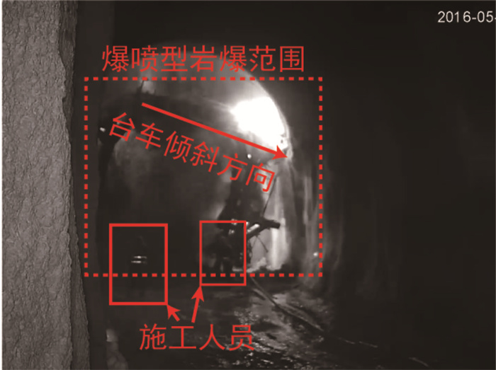
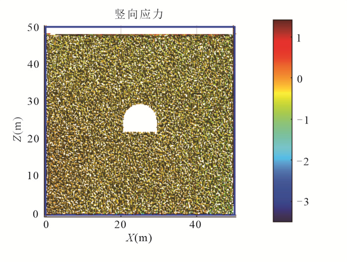
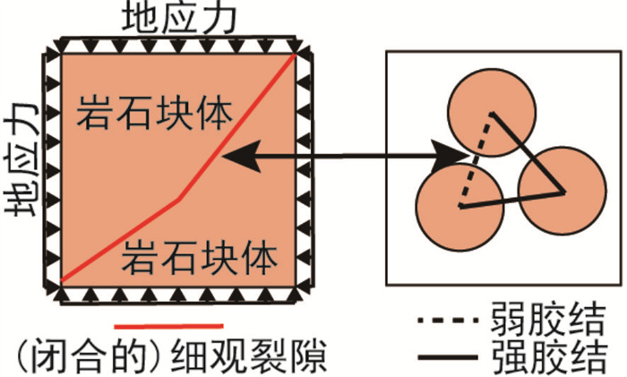
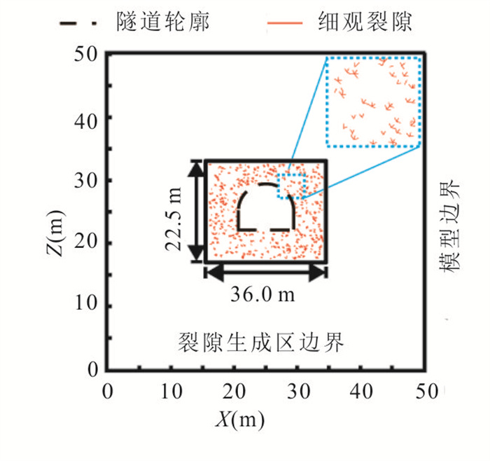
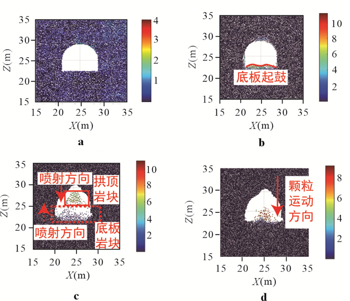
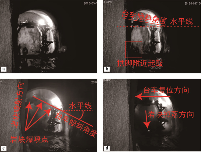
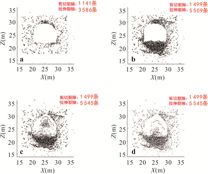
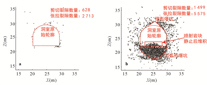
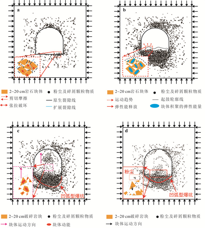
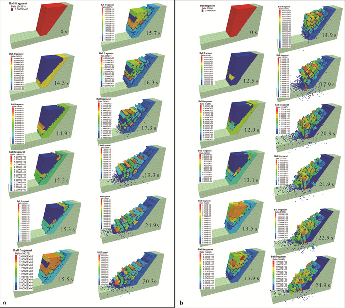
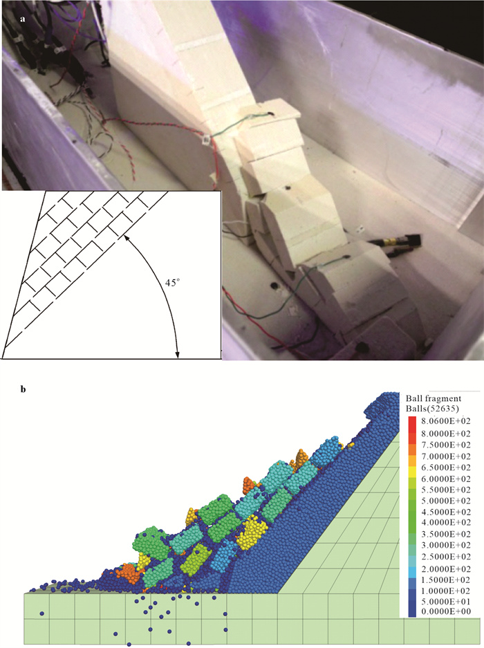
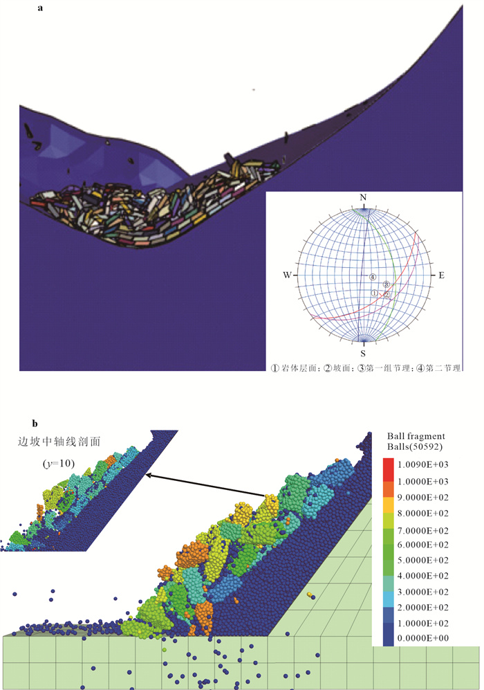
The occurrence environment and failure characteristics of explosive rockburst were collected and analyzed to explore the formation and evolution process of explosive rockburst in high geo-stress tunnels. The matrix discrete element numerical software MatDEM was used to simulate the phenomenon of explosive rockburst, and the mechanism of explosive rockburst was discussed. The results show that: (1) Explosive rock burst is a new type of rock burst phenomenon, rich in meso-fractures and squeezes rigid rock tunnels in high ground stress area of the suture zone. Under the action of excavation unloading disturbance, the surrounding rock bursts and breaks, and the sudden high-speed jet is accompanied by a large amount of dust. (2) The formation and evolution process of rockburst is divided into four stages: fracture activation and development stage, fracture aggregation and broken rock stage, high-speed jetting stage of broken rock block, and free-falling stage of broken rock block. (3) It is revealed that the geomechanical model of rockburst is tension-shear-jet type: under the action of excavation unloading disturbance, the surrounding rock of extruded rigid rock tunnel, which is rich in micro-fractures occurs aggregation fracture with tension failure as the primary and shear failure as the auxiliary. The elastic strain energy accumulated by the original extrusion suddenly releases and gives the broken rock high kinetic energy, and then the high-speed jet occurs. The research results provide a new understanding of rockburst formation and evolution process in complex rock tunnels in high-stress areas of the suture zone.
The occurrence environment and failure characteristics of explosive rockburst were collected and analyzed to explore the formation and evolution process of explosive rockburst in high geo-stress tunnels. The matrix discrete element numerical software MatDEM was used to simulate the phenomenon of explosive rockburst, and the mechanism of explosive rockburst was discussed. The results show that: (1) Explosive rock burst is a new type of rock burst phenomenon, rich in meso-fractures and squeezes rigid rock tunnels in high ground stress area of the suture zone. Under the action of excavation unloading disturbance, the surrounding rock bursts and breaks, and the sudden high-speed jet is accompanied by a large amount of dust. (2) The formation and evolution process of rockburst is divided into four stages: fracture activation and development stage, fracture aggregation and broken rock stage, high-speed jetting stage of broken rock block, and free-falling stage of broken rock block. (3) It is revealed that the geomechanical model of rockburst is tension-shear-jet type: under the action of excavation unloading disturbance, the surrounding rock of extruded rigid rock tunnel, which is rich in micro-fractures occurs aggregation fracture with tension failure as the primary and shear failure as the auxiliary. The elastic strain energy accumulated by the original extrusion suddenly releases and gives the broken rock high kinetic energy, and then the high-speed jet occurs. The research results provide a new understanding of rockburst formation and evolution process in complex rock tunnels in high-stress areas of the suture zone.
2024, 49(8): 2799-2812.
doi: 10.3799/dqkx.2023.062
Abstract:
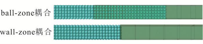
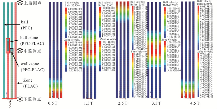
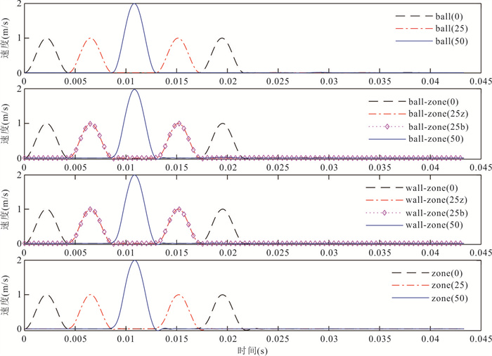
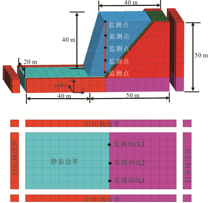
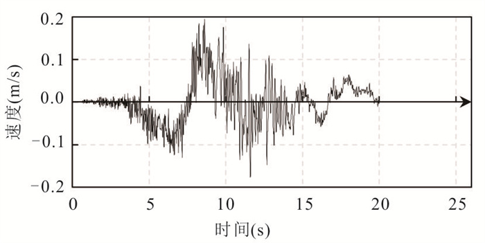
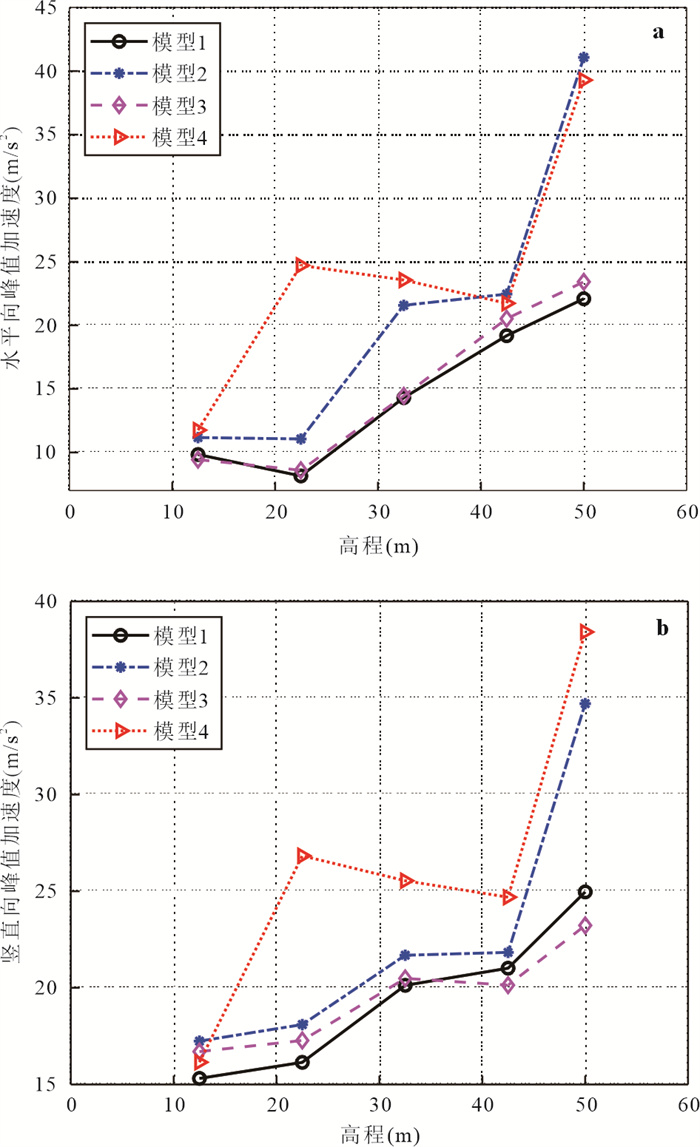
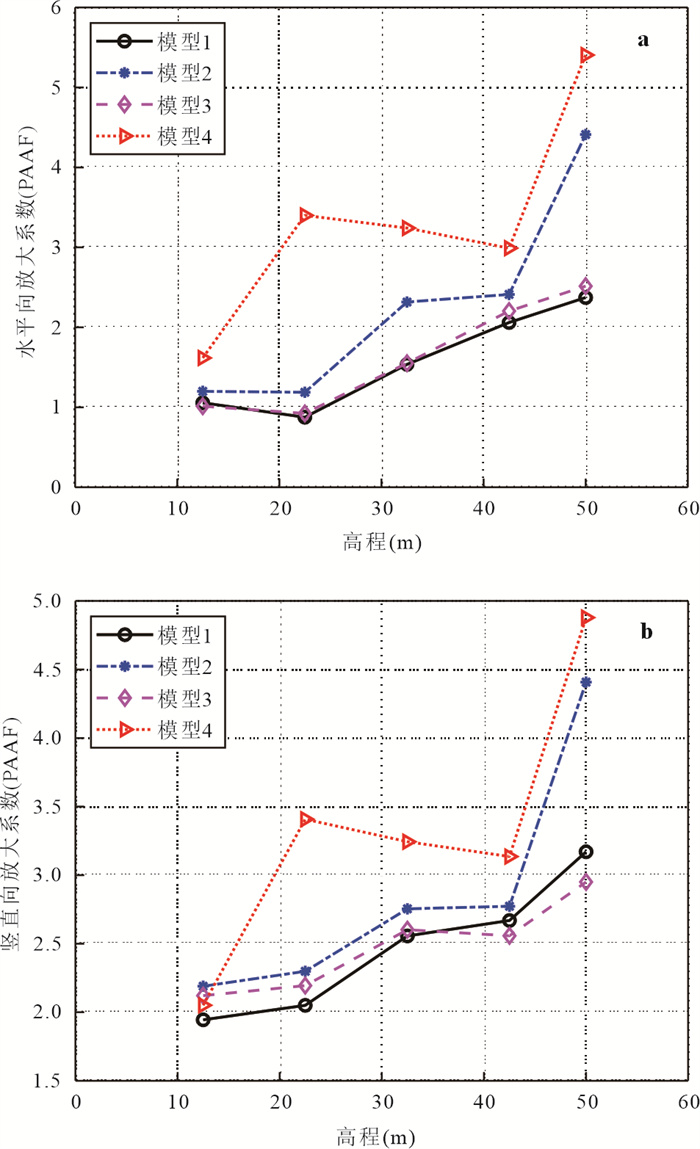
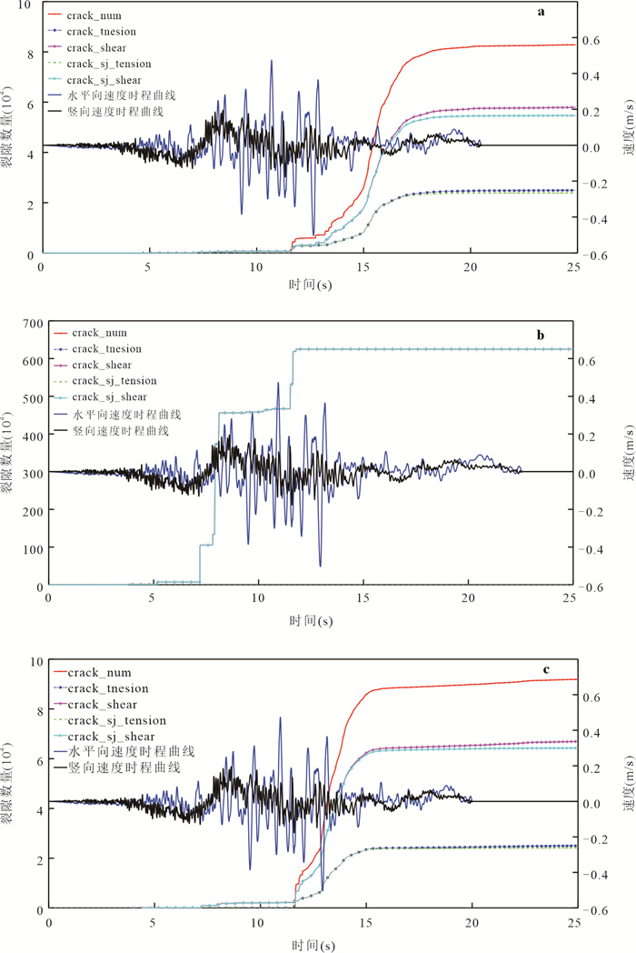
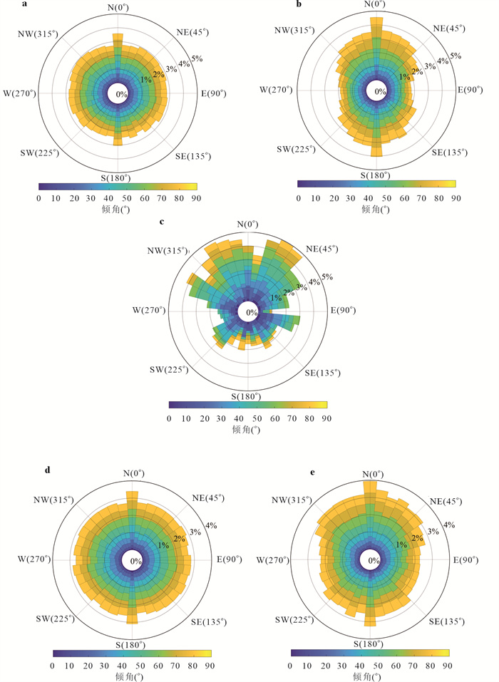
Based on the DEM-FDM coupling method, considering the three-dimensional extension of the structural plane and two directions of seismic wave, a numerical model of bedding rock slope with different structures is established in different areas, focusing on the dynamic response and deformation failure mechanism of bedding rock slope with different structures under strong earthquake. The following conclusions are drawn: (1) Under earthquake, there is a certain elevation amplification effect of slope acceleration, The horizontal amplification effect at the bottom of the slope is stronger than the vertical amplification effect, and the top amplification effect is equal. (2) Within the elevation range of 32.5-42.5 m, the existence of structural planes such as bedding planes and joints has a certain blocking effect on the propagation of seismic waves. The amplification effect of the slope shoulder is stronger than that of other parts, and the more developed the joints are, the stronger the amplification effect of the slope shoulder is. Compared with the joints whose dip-direction is 180°, the joints whose dip-direction is 90° have greater influence on the amplification effect. (3) The four models with different rock mass structures show different deformation and failure characteristics, including stability, local cracking, slip tension failure and slip collapse failure, respectively. Joints inclined to 90 ° are the main structural plane controlling the stability of bedding slope. Compared with the previous researches, the coupling method can better reveal thedynamicresponseand failure mode of bedding rock slopewith orthogonal secondary joints, and provide a certain reference for slope engineering in strong earthquake areas.
Based on the DEM-FDM coupling method, considering the three-dimensional extension of the structural plane and two directions of seismic wave, a numerical model of bedding rock slope with different structures is established in different areas, focusing on the dynamic response and deformation failure mechanism of bedding rock slope with different structures under strong earthquake. The following conclusions are drawn: (1) Under earthquake, there is a certain elevation amplification effect of slope acceleration, The horizontal amplification effect at the bottom of the slope is stronger than the vertical amplification effect, and the top amplification effect is equal. (2) Within the elevation range of 32.5-42.5 m, the existence of structural planes such as bedding planes and joints has a certain blocking effect on the propagation of seismic waves. The amplification effect of the slope shoulder is stronger than that of other parts, and the more developed the joints are, the stronger the amplification effect of the slope shoulder is. Compared with the joints whose dip-direction is 180°, the joints whose dip-direction is 90° have greater influence on the amplification effect. (3) The four models with different rock mass structures show different deformation and failure characteristics, including stability, local cracking, slip tension failure and slip collapse failure, respectively. Joints inclined to 90 ° are the main structural plane controlling the stability of bedding slope. Compared with the previous researches, the coupling method can better reveal thedynamicresponseand failure mode of bedding rock slopewith orthogonal secondary joints, and provide a certain reference for slope engineering in strong earthquake areas.


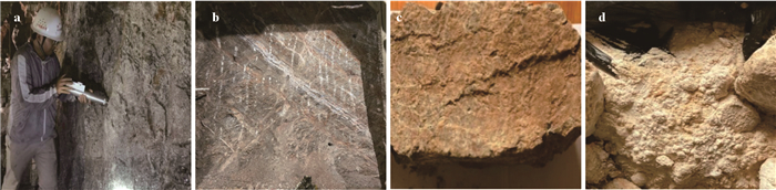
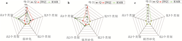
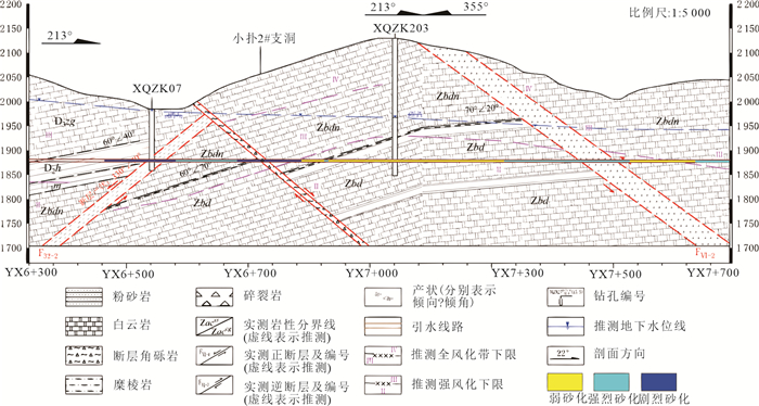
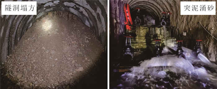
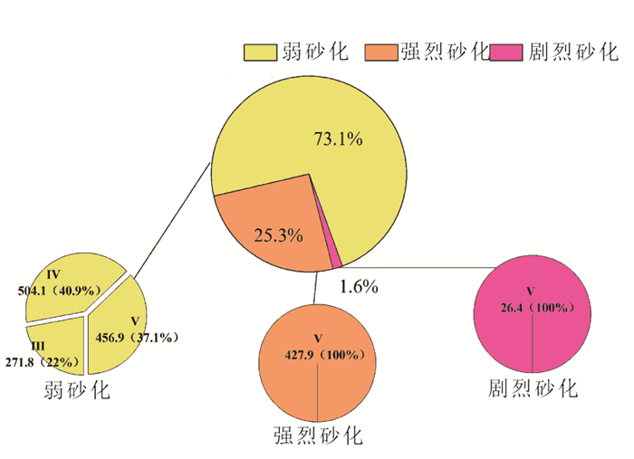
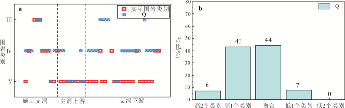
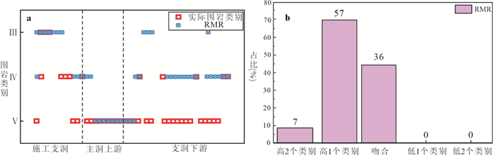
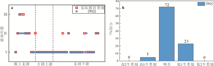
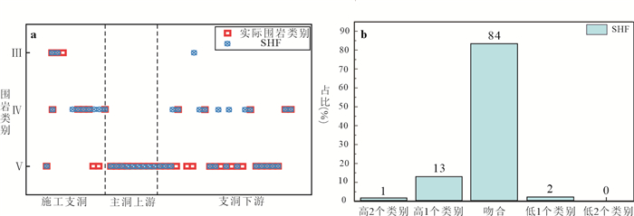
Structure and Application of SHF Classification Method for Surrounding Rock of Sandy Dolomite Tunnel
2024, 49(8): 2813-2825.
doi: 10.3799/dqkx.2023.059
Abstract:
Sandy dolomite is widely distributed in the southwest of China. When tunnels are built in this stratum, geological disasters such as face collapse, water inrush and sand gushing often occur. Therefore, the problem of sandy dolomite faced in the construction of water diversion project in central Yunnan has attracted much attention. The sanding grade and groundwater conditions are the key factors to control the failure mode and stability of the surrounding rock of the sanded dolomite tunnel. However, these factors are often not fully considered in the traditional surrounding rock classification methods, such as the rock strength is not considered in the Q system, the ground stress is not considered in the RMR method, and the joint state and roughness of the sandy dolomite are not considered in the BQ method. Totally, these classification methods do not take into account the influence of sanding grade. In order to make the surrounding rock classification results of the sandy dolomite tunnel more accurate and faster, it is necessary to build a classification method suitable for the sandy dolomite tunnel. Based on the water diversion project in central Yunnan under construction, we analyze the applicability of traditional methods such as Q method, RMR method, RMi method, GSI method and BQ method in sandy dolomite tunnel. Secondly, combined with the engineering characteristics of sandy dolomite and the external environmental factors, the surrounding rock classification system SHF with the evaluation indexes of sanding grade, structural plane state, groundwater, main structural plane state and ground stress is constructed, and the SHF classification method is verified and applied by selected typical tunnel sections of the project. The established classification method SHF for surrounding rock of sandy dolomite tunnel is prone to operate and highly consistent with the actual situation of the project. The research can provide a theoretical basis for the design and construction of sanded dolomite tunnel support.
Sandy dolomite is widely distributed in the southwest of China. When tunnels are built in this stratum, geological disasters such as face collapse, water inrush and sand gushing often occur. Therefore, the problem of sandy dolomite faced in the construction of water diversion project in central Yunnan has attracted much attention. The sanding grade and groundwater conditions are the key factors to control the failure mode and stability of the surrounding rock of the sanded dolomite tunnel. However, these factors are often not fully considered in the traditional surrounding rock classification methods, such as the rock strength is not considered in the Q system, the ground stress is not considered in the RMR method, and the joint state and roughness of the sandy dolomite are not considered in the BQ method. Totally, these classification methods do not take into account the influence of sanding grade. In order to make the surrounding rock classification results of the sandy dolomite tunnel more accurate and faster, it is necessary to build a classification method suitable for the sandy dolomite tunnel. Based on the water diversion project in central Yunnan under construction, we analyze the applicability of traditional methods such as Q method, RMR method, RMi method, GSI method and BQ method in sandy dolomite tunnel. Secondly, combined with the engineering characteristics of sandy dolomite and the external environmental factors, the surrounding rock classification system SHF with the evaluation indexes of sanding grade, structural plane state, groundwater, main structural plane state and ground stress is constructed, and the SHF classification method is verified and applied by selected typical tunnel sections of the project. The established classification method SHF for surrounding rock of sandy dolomite tunnel is prone to operate and highly consistent with the actual situation of the project. The research can provide a theoretical basis for the design and construction of sanded dolomite tunnel support.
2024, 49(8): 2826-2838.
doi: 10.3799/dqkx.2023.026
Abstract:
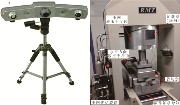
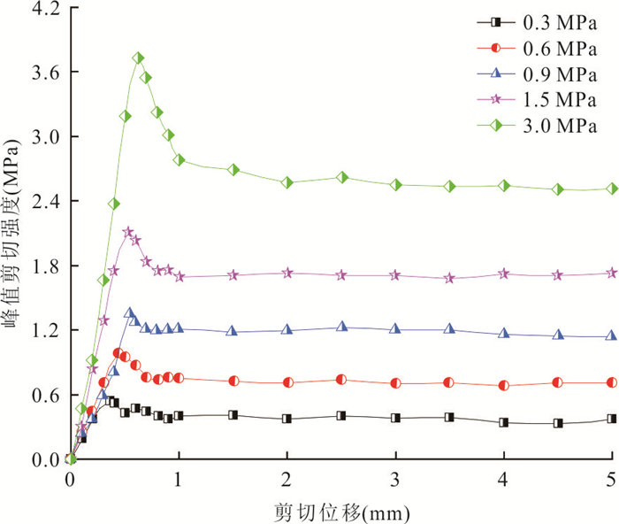
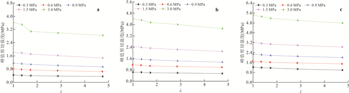
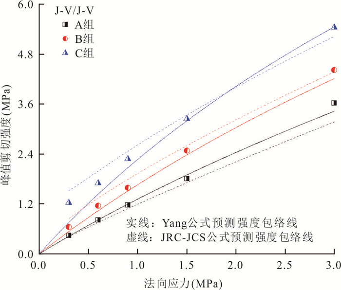
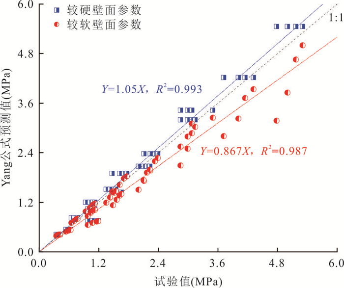
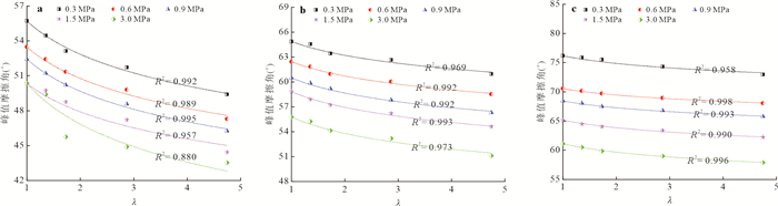
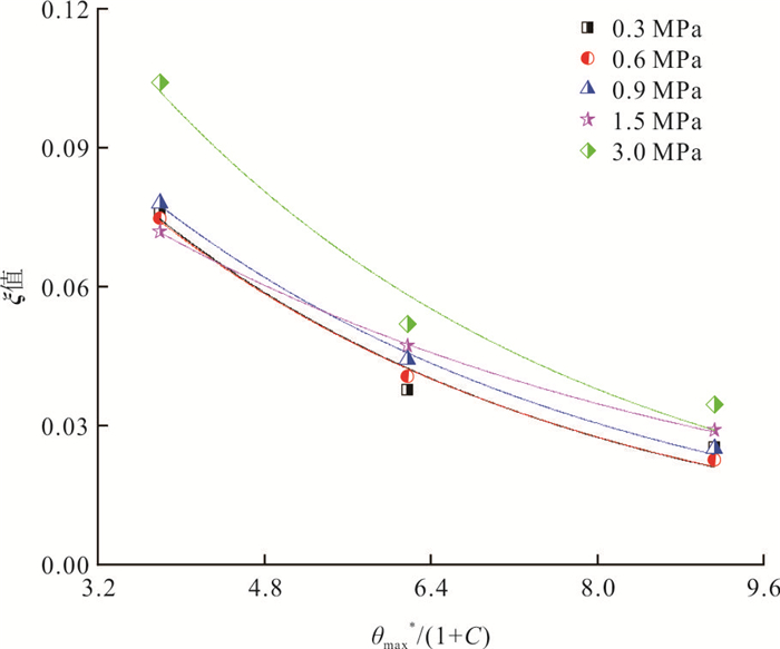
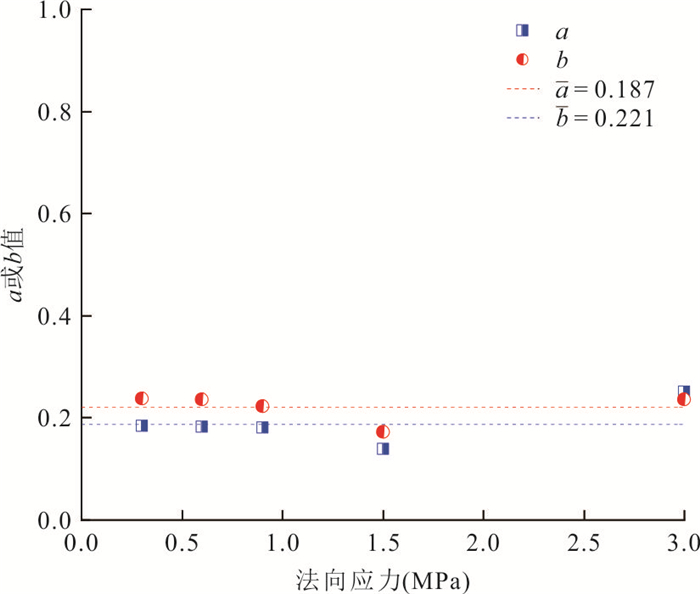
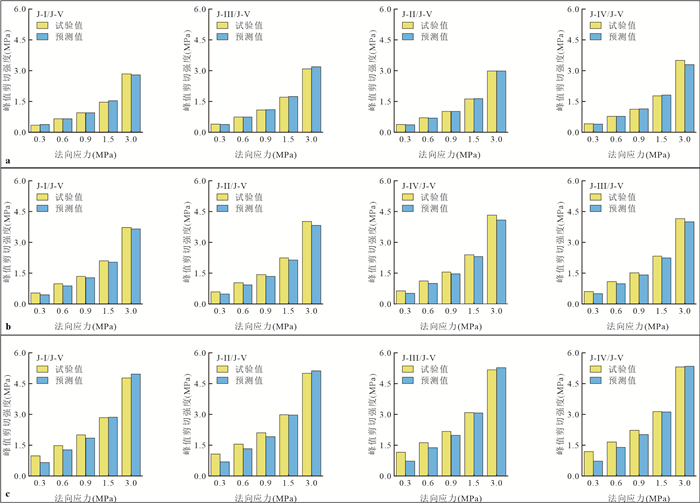
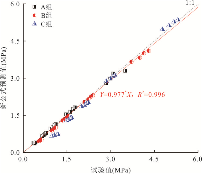
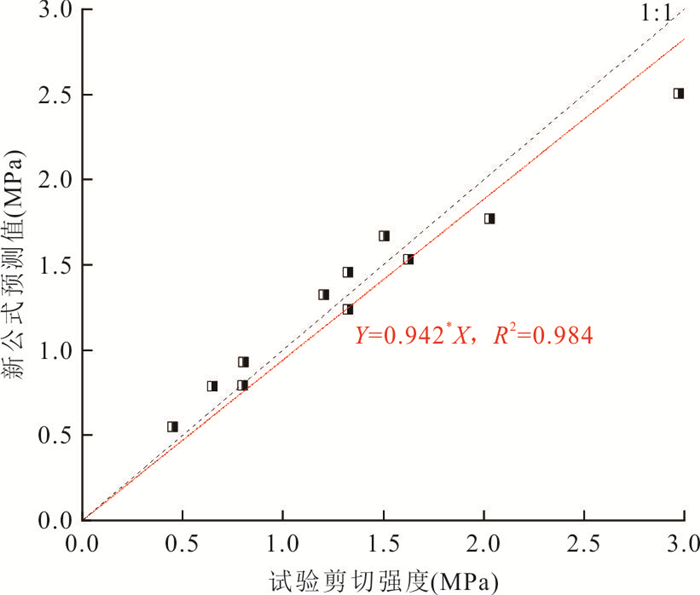
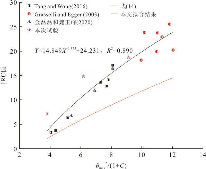
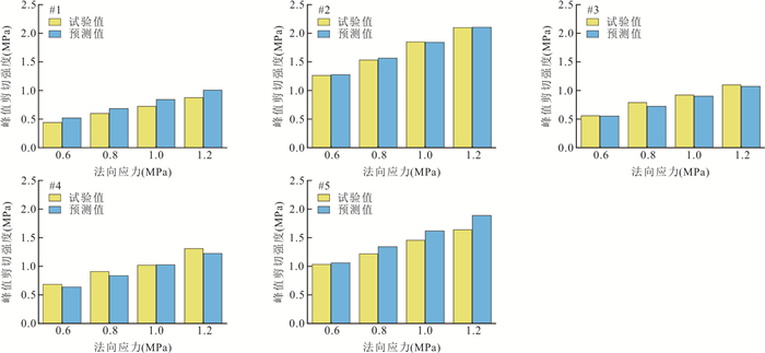
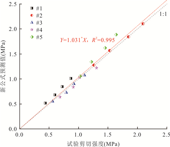
Discontinuities with different rock types are widely distributed in the Three Gorges reservoir area, and accurately evaluating the peak shear strengths of them is vital for rock mass stability analysis in this reservoir area. A batch of rock-like joint replicas with the same natural morphology but different joint wall strength combinations is prepared, and direct shear tests are conducted on them under constant normal stresses ranging from 0.3 to 3.0 MPa. Further, the joint wall strength combination coefficient (λ) is introduced to capture the combined effect of rock compressive strength and basic angle on the peak shear strength of discontinuities with different rock types. Testing results illustrate that the peak shear strengths of discontinuities with different rock types decrease non⁃linearly with increasing λ, and the decrease degree is mainly controlled by roughness while showing no obvious relationship with normal stress. A simple power law function is selected to analyze the correlation between the peak friction angles and λ, and an empirical strength criterion with the inclusion of three⁃dimensional morphology parameters is developed to predict the peak shear strengths of discontinuities with different rock types. Finally, natural samples collected from the Three Gorges reservoir area are used to further validate the reliability of the new criterion for evaluating the peak shear strength of natural discontinuities with different rock types. To some extent, the new criterion can provide a theoretical basis for the stability evaluation of rock masses containing discontinuities with different rock types in the Three Gorges reservoir area.
Discontinuities with different rock types are widely distributed in the Three Gorges reservoir area, and accurately evaluating the peak shear strengths of them is vital for rock mass stability analysis in this reservoir area. A batch of rock-like joint replicas with the same natural morphology but different joint wall strength combinations is prepared, and direct shear tests are conducted on them under constant normal stresses ranging from 0.3 to 3.0 MPa. Further, the joint wall strength combination coefficient (λ) is introduced to capture the combined effect of rock compressive strength and basic angle on the peak shear strength of discontinuities with different rock types. Testing results illustrate that the peak shear strengths of discontinuities with different rock types decrease non⁃linearly with increasing λ, and the decrease degree is mainly controlled by roughness while showing no obvious relationship with normal stress. A simple power law function is selected to analyze the correlation between the peak friction angles and λ, and an empirical strength criterion with the inclusion of three⁃dimensional morphology parameters is developed to predict the peak shear strengths of discontinuities with different rock types. Finally, natural samples collected from the Three Gorges reservoir area are used to further validate the reliability of the new criterion for evaluating the peak shear strength of natural discontinuities with different rock types. To some extent, the new criterion can provide a theoretical basis for the stability evaluation of rock masses containing discontinuities with different rock types in the Three Gorges reservoir area.


2024, 49(8): 2839-2850.
doi: 10.3799/dqkx.2023.035
Abstract:
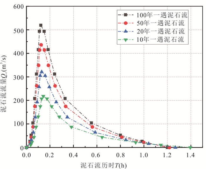
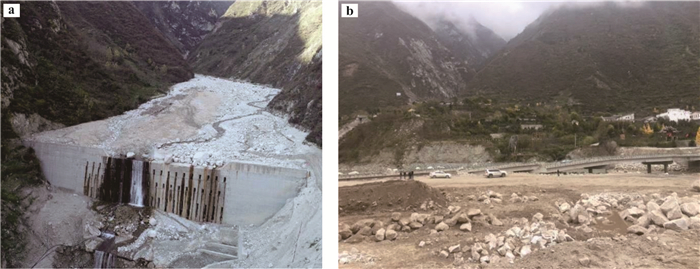
The debris flow hazard was more serious with the increase of occurrence probability of low-frequency debris flow after the earthquake. Resulting in the damage of retaining dam and reduction of its capabilities in disaster prevention and reduction. But few studies payed attention to the influence of retaining dam on debris flow hazard. Moreover, disaster-pregnant factors were usually used as the index of debris flow hazard, but the result of hazard evaluation could not completely reflect the destructive power and intensity of debris flow. Thus, the dynamic parameters of debris flow and the stability coefficient of retaining dam in different return periods were calculated in Chutou gully. And the debris flow hazard was evaluated based on dynamic parameters of debris flow and improved entropy method. And the control relationship between retaining dam and debris flow hazard was analyzed. The study findings were as follows: Reasonable evaluation results could be obtained by dynamic parameters and improved entropy method. The values of debris flow hazard were decreased about 12.27%~43.75% with different return periods (1%, 2%, 5% and 10%) under the influence of the retaining dam, due to the discharge of debris flow was decreased below the retaining dam. This work may provide some new clues for prevention and control of debris flow and optimum design of retaining dam.
The debris flow hazard was more serious with the increase of occurrence probability of low-frequency debris flow after the earthquake. Resulting in the damage of retaining dam and reduction of its capabilities in disaster prevention and reduction. But few studies payed attention to the influence of retaining dam on debris flow hazard. Moreover, disaster-pregnant factors were usually used as the index of debris flow hazard, but the result of hazard evaluation could not completely reflect the destructive power and intensity of debris flow. Thus, the dynamic parameters of debris flow and the stability coefficient of retaining dam in different return periods were calculated in Chutou gully. And the debris flow hazard was evaluated based on dynamic parameters of debris flow and improved entropy method. And the control relationship between retaining dam and debris flow hazard was analyzed. The study findings were as follows: Reasonable evaluation results could be obtained by dynamic parameters and improved entropy method. The values of debris flow hazard were decreased about 12.27%~43.75% with different return periods (1%, 2%, 5% and 10%) under the influence of the retaining dam, due to the discharge of debris flow was decreased below the retaining dam. This work may provide some new clues for prevention and control of debris flow and optimum design of retaining dam.

2024, 49(8): 2851-2861.
doi: 10.3799/dqkx.2023.054
Abstract:
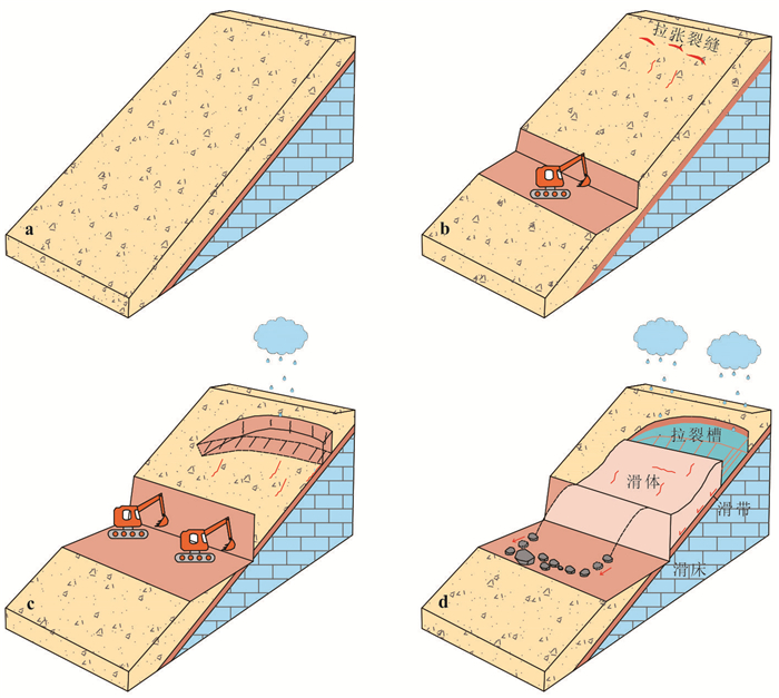
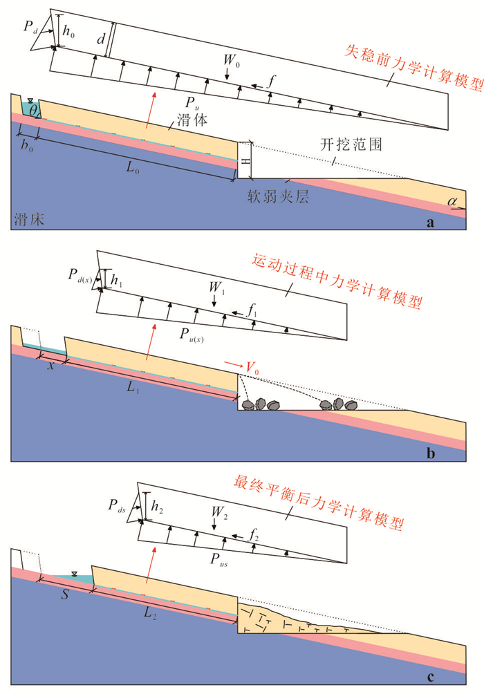
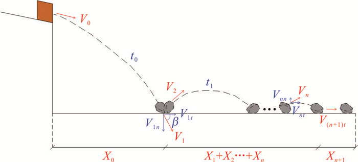
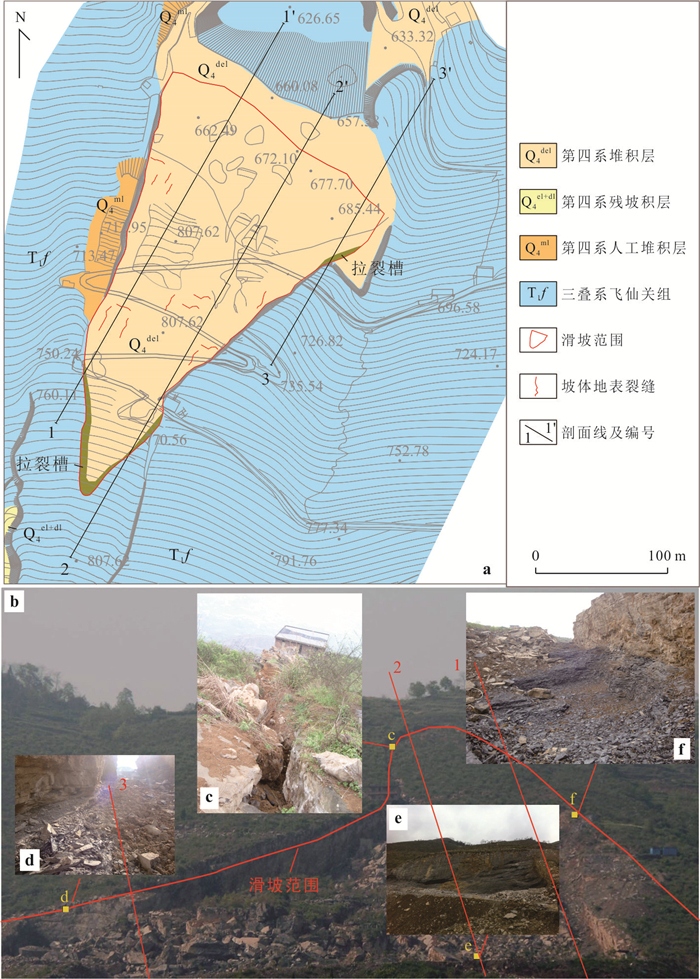
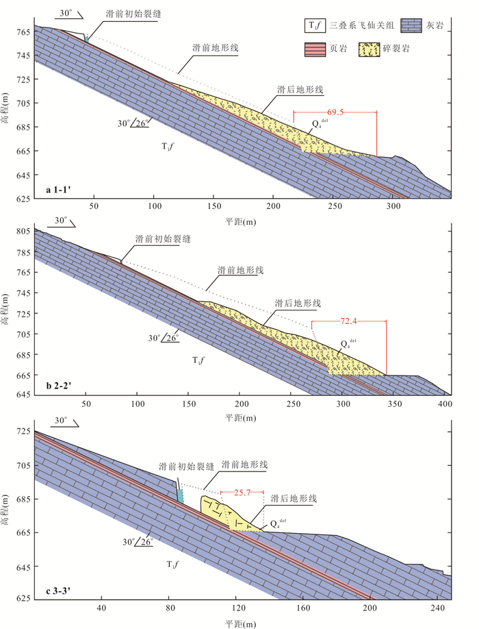
Bedding rock landslide exists widely in slope engineering. Its movement distance is an important parameter to characterize the landslide form and a significant index for risk evaluation. Based on the analysis of the evolution process, the runout distance of the bedding rock landslide is obtained by the theoretical derivation, and the achievements are applied to the Xinjianan landslide. The results showed three parts consisting of movement distance. The horizontal distance of the block in the air is the first, and the mobile distance of the collision with the ground is the next while the sliding distance on the ground is the last. Besides, the relative error between theoretical calculation and the actual measurements selected for the three profiles of the landslide are 9.99%, 2.53%, and 0.58% respectively. The error is small and shows the good application of the model. The research has a reference value for predicting and preventing this type of landslide.
Bedding rock landslide exists widely in slope engineering. Its movement distance is an important parameter to characterize the landslide form and a significant index for risk evaluation. Based on the analysis of the evolution process, the runout distance of the bedding rock landslide is obtained by the theoretical derivation, and the achievements are applied to the Xinjianan landslide. The results showed three parts consisting of movement distance. The horizontal distance of the block in the air is the first, and the mobile distance of the collision with the ground is the next while the sliding distance on the ground is the last. Besides, the relative error between theoretical calculation and the actual measurements selected for the three profiles of the landslide are 9.99%, 2.53%, and 0.58% respectively. The error is small and shows the good application of the model. The research has a reference value for predicting and preventing this type of landslide.
2024, 49(8): 2862-2878.
doi: 10.3799/dqkx.2023.051
Abstract:
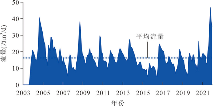
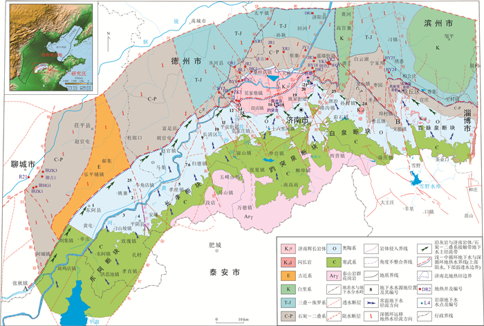
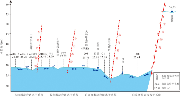
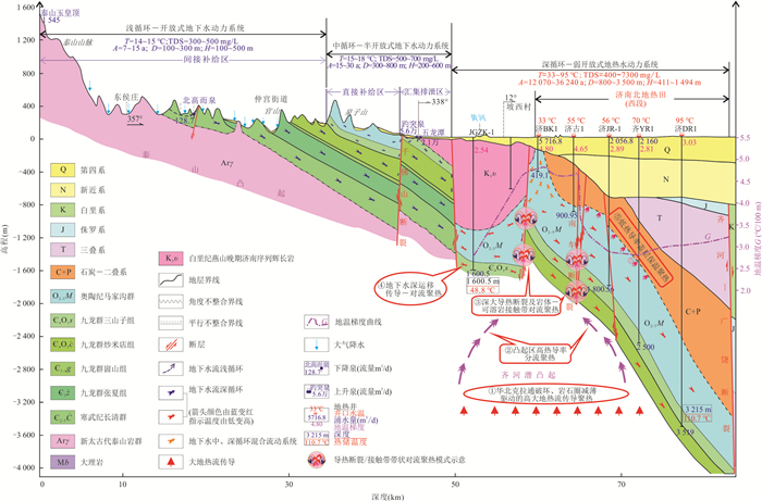
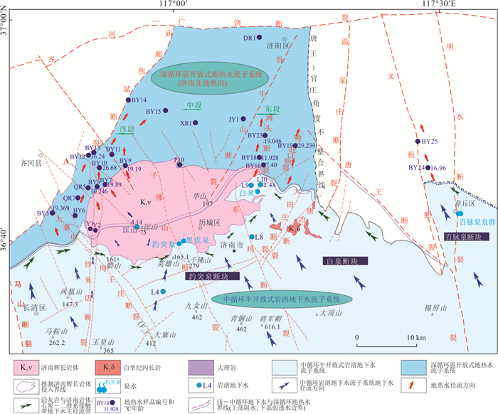
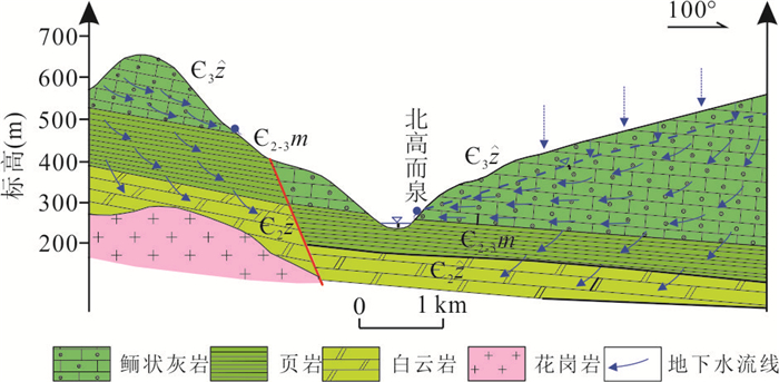
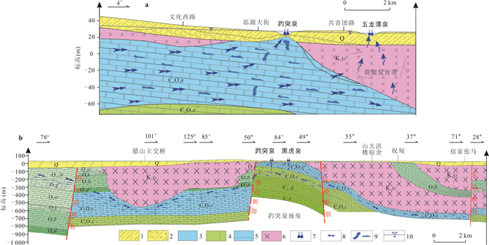
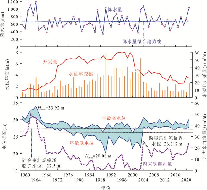
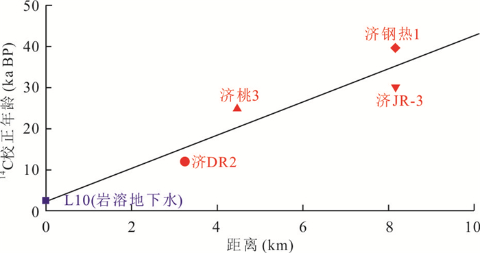
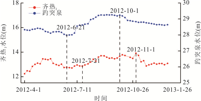
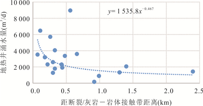
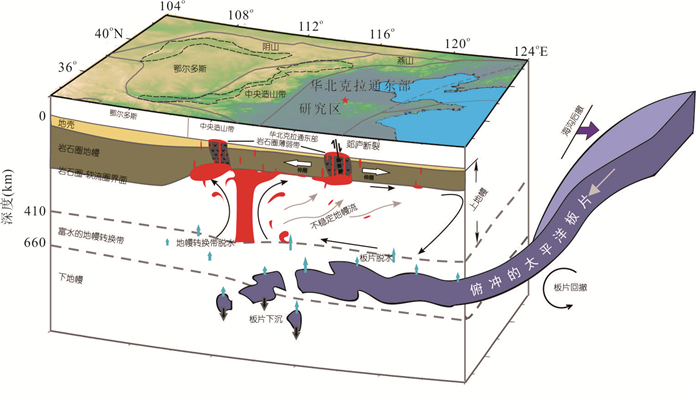
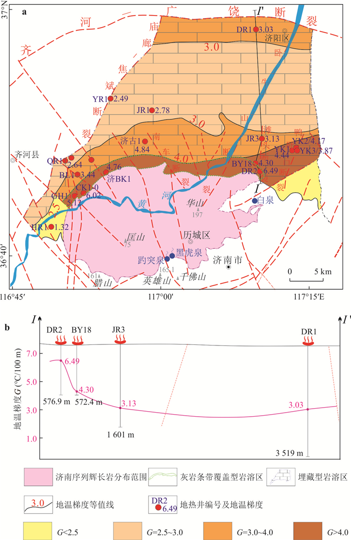
To discriminate the correlation between normal temperature groundwater and geothermal water, by analyzing the characteristics and patterns of spatial distribution of aquifer/thermal reservoir, isotopic dating, hydrogeochemical field, hydrodynamic field and temperature field, the evolution process and driving mechanism of karst groundwater flow system in Baotu spring catchment from shallow to middle and to deep circulation subsystems, i.e., from cold springs to hot springs, are revealed. Driven by the gravitational potential energy difference, the groundwater flows from the open groundwater flow system in the upper reaches to the semi-open groundwater flow system in the middle reaches along the Jinan karst aquifer system.A small part of groundwater passes through from the deep or bypasses the Jinan gabbro mass, and migrates to the downstream along the fissure karst channel, forming a weakly open geothermal water flow system. Such five sources of heat accumulation drive normal temperature groundwater of 14-18℃ to be heated into geothermal water of 33-95 ℃ as the high terrestrial heat flux accumulation, the belt shaped convective thermal accumulation in the deep fault zone or intrusive rock-limestone contact zone, the high thermal conductivity diffluence accumulation in the uplift area, theheat preservation accumulation by low thermal conductivity cap rock, and the conductive-convective thermal accumulation by deep groundwater circulation.
To discriminate the correlation between normal temperature groundwater and geothermal water, by analyzing the characteristics and patterns of spatial distribution of aquifer/thermal reservoir, isotopic dating, hydrogeochemical field, hydrodynamic field and temperature field, the evolution process and driving mechanism of karst groundwater flow system in Baotu spring catchment from shallow to middle and to deep circulation subsystems, i.e., from cold springs to hot springs, are revealed. Driven by the gravitational potential energy difference, the groundwater flows from the open groundwater flow system in the upper reaches to the semi-open groundwater flow system in the middle reaches along the Jinan karst aquifer system.A small part of groundwater passes through from the deep or bypasses the Jinan gabbro mass, and migrates to the downstream along the fissure karst channel, forming a weakly open geothermal water flow system. Such five sources of heat accumulation drive normal temperature groundwater of 14-18℃ to be heated into geothermal water of 33-95 ℃ as the high terrestrial heat flux accumulation, the belt shaped convective thermal accumulation in the deep fault zone or intrusive rock-limestone contact zone, the high thermal conductivity diffluence accumulation in the uplift area, theheat preservation accumulation by low thermal conductivity cap rock, and the conductive-convective thermal accumulation by deep groundwater circulation.
2024, 49(8): 2879-2890.
doi: 10.3799/dqkx.2022.103
Abstract:
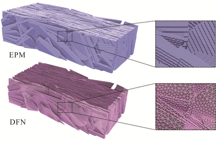
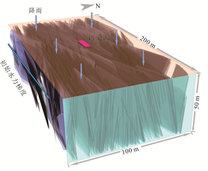
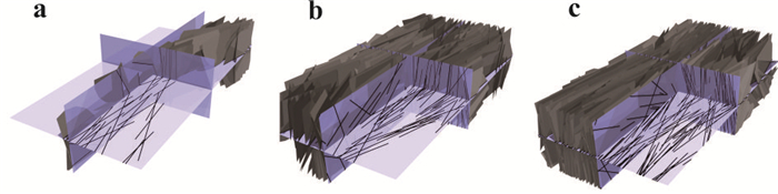
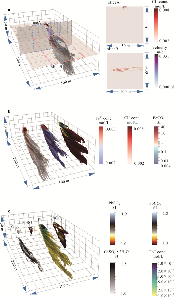
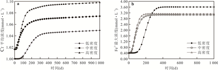
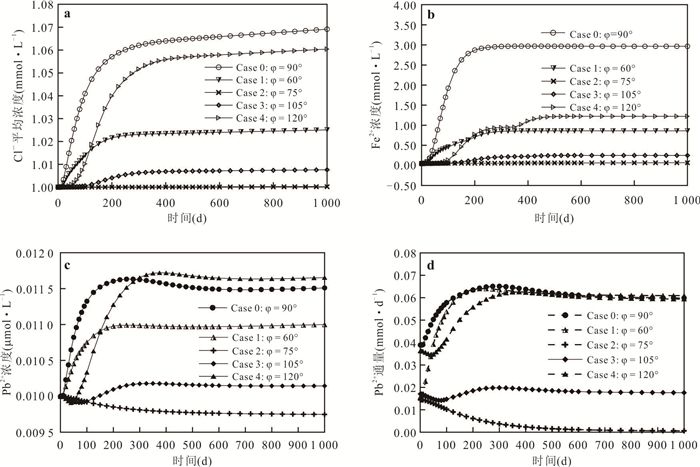
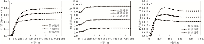
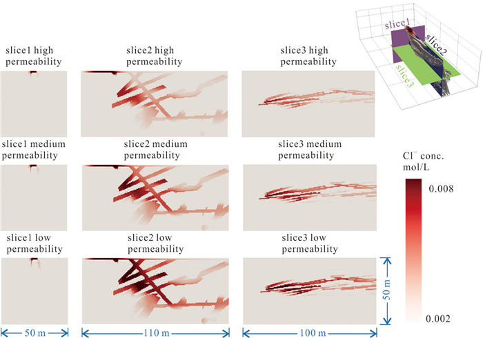
The geologic discontinuities present in natural fractured rock governs groundwater flow and solute transport process. Due to the complexity of real-world fracture network, discrete fracture network (DFN) is often be described and generated based on specific probability distributions determined by different parameters (shape, location, size, density, orientation, etc.). Due to DFN's highly heterogeneous and an isotropic features, it's a challenge to simulate groundwater flow and solute transport processes using traditional numerical solution based on the experience achieved in porous media. In this paper, a 3-D DFN model is built for field-scale study, and mapped to an equivalent porous medium (EPM) model, which further couples groundwater flow model with the multi-component reactive transport code PFLOTRAN to achieve numerical simulation of the reactive transport process of heavy metal contaminants in the fractured network and quantitative assessment of mass fluxes. The study shows that the behavior of the fracture network gradually transforms into the transport in porous media as the density of the network increases; Both the density and orientation of fracture development affect the connectivity of the fracture network, which in turn affects the migration pattern and flux assessment of different components in fractured rock groundwater flow, where the migration behavior of conservative components and various reactive components are significantly different.Meanwhile, it is shown that roughness has an important influence on the migration process and flux assessment of the transport components in the fracture network.This paper provides an effective simulation and quantitative assessment tool for the reactive transport of heavy metals and groundwater flow in the fractured field.
The geologic discontinuities present in natural fractured rock governs groundwater flow and solute transport process. Due to the complexity of real-world fracture network, discrete fracture network (DFN) is often be described and generated based on specific probability distributions determined by different parameters (shape, location, size, density, orientation, etc.). Due to DFN's highly heterogeneous and an isotropic features, it's a challenge to simulate groundwater flow and solute transport processes using traditional numerical solution based on the experience achieved in porous media. In this paper, a 3-D DFN model is built for field-scale study, and mapped to an equivalent porous medium (EPM) model, which further couples groundwater flow model with the multi-component reactive transport code PFLOTRAN to achieve numerical simulation of the reactive transport process of heavy metal contaminants in the fractured network and quantitative assessment of mass fluxes. The study shows that the behavior of the fracture network gradually transforms into the transport in porous media as the density of the network increases; Both the density and orientation of fracture development affect the connectivity of the fracture network, which in turn affects the migration pattern and flux assessment of different components in fractured rock groundwater flow, where the migration behavior of conservative components and various reactive components are significantly different.Meanwhile, it is shown that roughness has an important influence on the migration process and flux assessment of the transport components in the fracture network.This paper provides an effective simulation and quantitative assessment tool for the reactive transport of heavy metals and groundwater flow in the fractured field.
2024, 49(8): 2891-2900.
doi: 10.3799/dqkx.2023.060
Abstract:
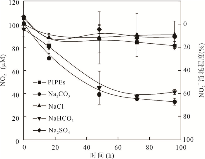
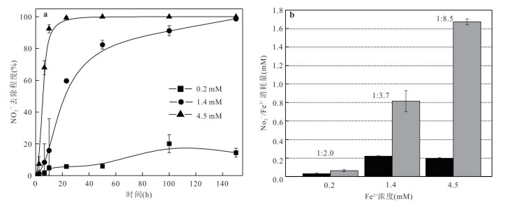
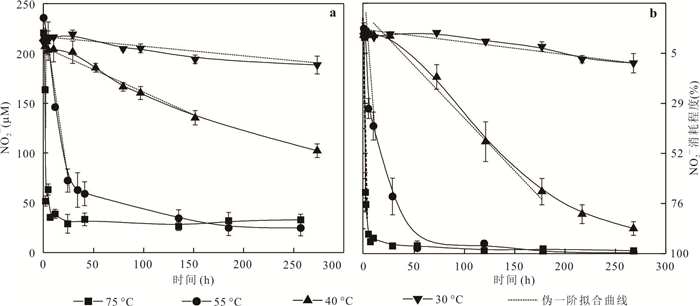
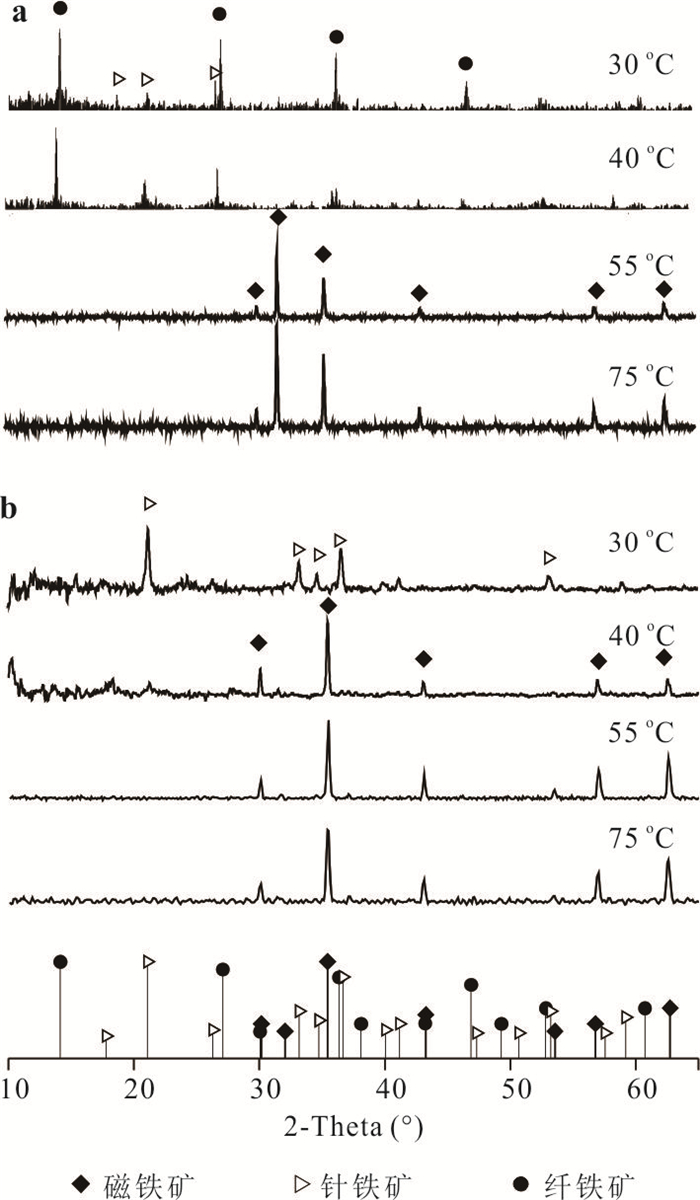
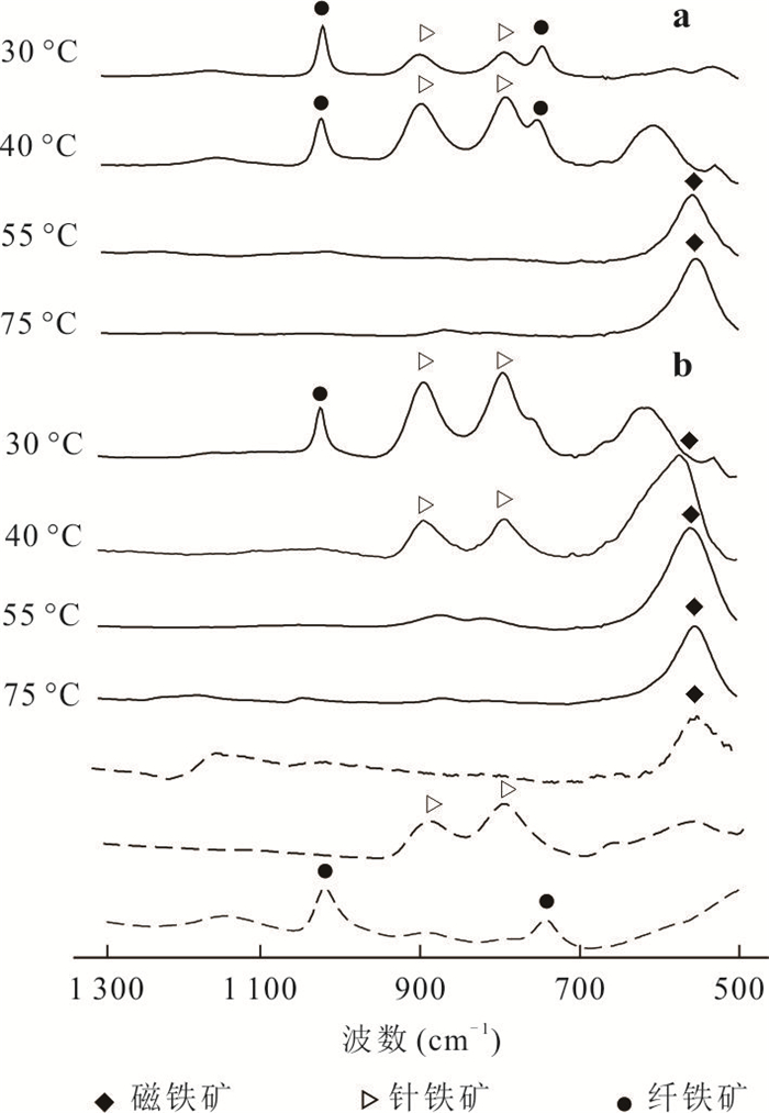
To improve the efficiency of the NO2- removal process using Fe2+ as a reducing agent in practical applications, this research designed three environmental factors of exogenous anions, Fe2+ concentration, and reaction temperature to investigate their effects on the chemical reduction of NO2- by Fe2+. The results showed that although increasing the Fe2+ concentration could significantly promote the removal rate of NO2-, it also reduced the utilization rate of Fe2+. In addition, raising the temperature and adding HCO3-/CO32- could both increase the removal rate and extent of NO2-. The type of by-product formed by iron oxidation was also regulated by temperature and HCO3-. At temperatures below 55 ℃ (such as 30 ℃ and 40 ℃), the by-product of iron oxidation was mainly goethite and magnetite. At temperatures above 55 ℃, Magnetite was the only by-product. But magnetite can be formed at a lower temperature (40 ℃) with HCO3-. These results provide experimental references for improving the application mode and by-product secondary treatment utilization of Fe2+-based Chemo-denitrification and provide theoretical basis in actual engineering.
To improve the efficiency of the NO2- removal process using Fe2+ as a reducing agent in practical applications, this research designed three environmental factors of exogenous anions, Fe2+ concentration, and reaction temperature to investigate their effects on the chemical reduction of NO2- by Fe2+. The results showed that although increasing the Fe2+ concentration could significantly promote the removal rate of NO2-, it also reduced the utilization rate of Fe2+. In addition, raising the temperature and adding HCO3-/CO32- could both increase the removal rate and extent of NO2-. The type of by-product formed by iron oxidation was also regulated by temperature and HCO3-. At temperatures below 55 ℃ (such as 30 ℃ and 40 ℃), the by-product of iron oxidation was mainly goethite and magnetite. At temperatures above 55 ℃, Magnetite was the only by-product. But magnetite can be formed at a lower temperature (40 ℃) with HCO3-. These results provide experimental references for improving the application mode and by-product secondary treatment utilization of Fe2+-based Chemo-denitrification and provide theoretical basis in actual engineering.
2024, 49(8): 2901-2913.
doi: 10.3799/dqkx.2023.039
Abstract:
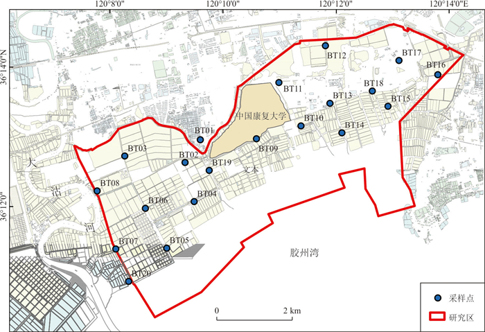
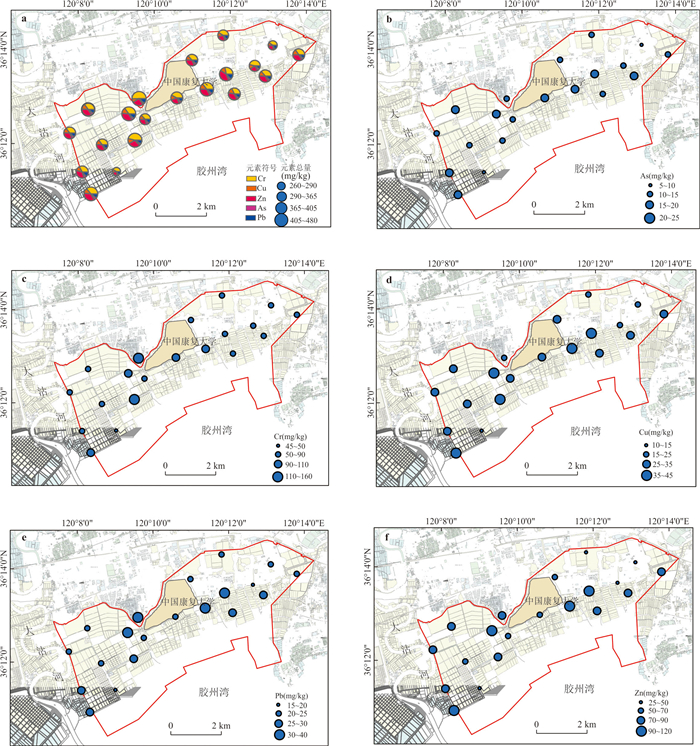
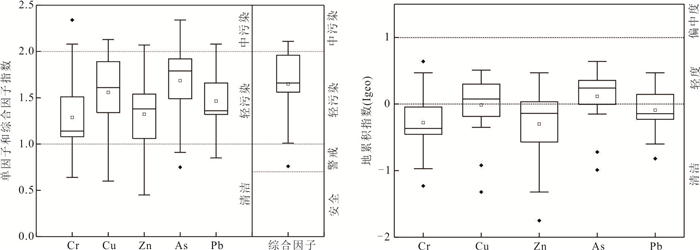
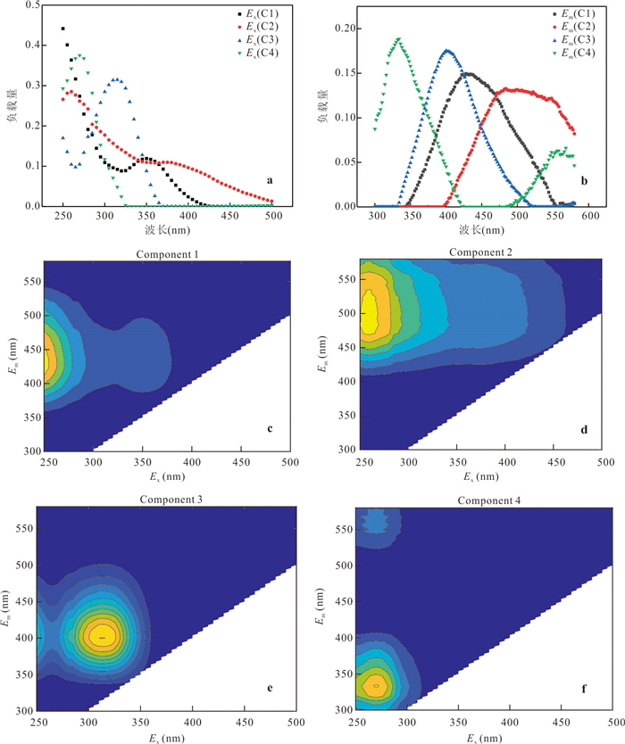
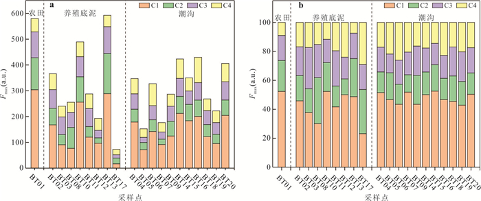
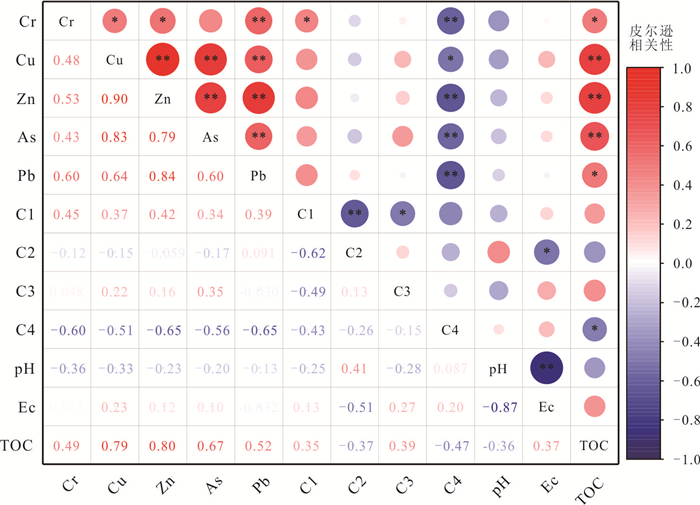
Coastal zone sediments are the main carriers and destinations for the migration and transformation of pollutants. Dissolved organic matter (DOM), as an important medium for heavy metal migration in the environment, plays an important role in controlling the distribution and migration of heavy metals in sediments. The paper used the factor index and ground accumulation index methods to assess the current pollution status of five heavy metals, Cr, Cu, Zn, As and Pb, in the Surface sediment of the northern coastal zone of Jiaozhou Bay, and combined with three-dimensional fluorescence spectroscopy to analyze the spatial partitioning patterns of different DOM components in sediments, to explore the relationship between DOM composition and heavy metal migration behavior in the Surface sediment of the northern Jiaozhou Bay area. The results showed that the overall heavy metals in the coastal zone sediments were lightly contaminated; the natural DOM fractions in the sediments included four types of terrestrial fulvic acid (C1), terrestrial humic substances (C2), microbial-derived humic substances (C3) and tryptophan-like (C4), and the proportion of humic acid fractions was significantly higher than that of protein-like fractions in the whole area, and their sources were influenced by both terrestrial input and biological metabolism. Each heavy metal may have similar pollution sources, but different migration mechanisms cause differences in their distribution; C1 promotes the natural migration of Cr, each DOM fraction influences the distribution of heavy metals in sediments through different adsorption complexation mechanisms, and there are certain mutual transformation processes among DOM fractions.
Coastal zone sediments are the main carriers and destinations for the migration and transformation of pollutants. Dissolved organic matter (DOM), as an important medium for heavy metal migration in the environment, plays an important role in controlling the distribution and migration of heavy metals in sediments. The paper used the factor index and ground accumulation index methods to assess the current pollution status of five heavy metals, Cr, Cu, Zn, As and Pb, in the Surface sediment of the northern coastal zone of Jiaozhou Bay, and combined with three-dimensional fluorescence spectroscopy to analyze the spatial partitioning patterns of different DOM components in sediments, to explore the relationship between DOM composition and heavy metal migration behavior in the Surface sediment of the northern Jiaozhou Bay area. The results showed that the overall heavy metals in the coastal zone sediments were lightly contaminated; the natural DOM fractions in the sediments included four types of terrestrial fulvic acid (C1), terrestrial humic substances (C2), microbial-derived humic substances (C3) and tryptophan-like (C4), and the proportion of humic acid fractions was significantly higher than that of protein-like fractions in the whole area, and their sources were influenced by both terrestrial input and biological metabolism. Each heavy metal may have similar pollution sources, but different migration mechanisms cause differences in their distribution; C1 promotes the natural migration of Cr, each DOM fraction influences the distribution of heavy metals in sediments through different adsorption complexation mechanisms, and there are certain mutual transformation processes among DOM fractions.
2024, 49(8): 2914-2924.
doi: 10.3799/dqkx.2024.036
Abstract:
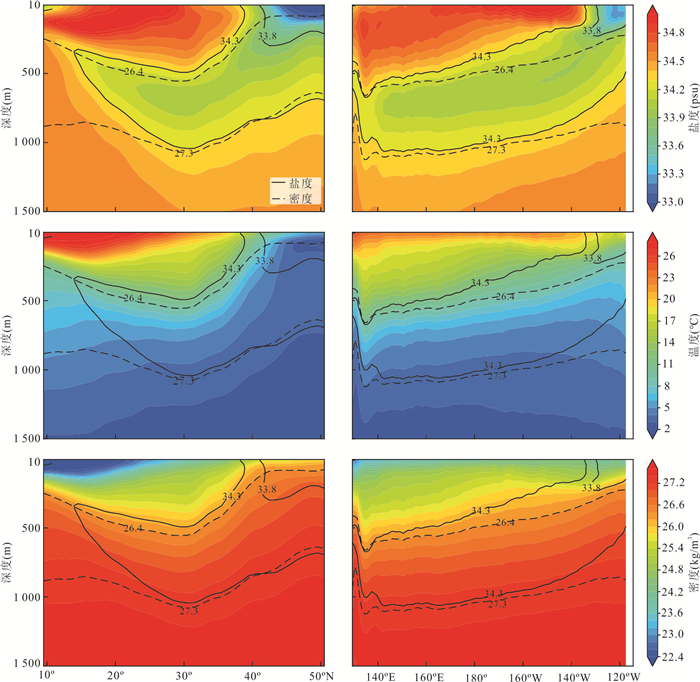
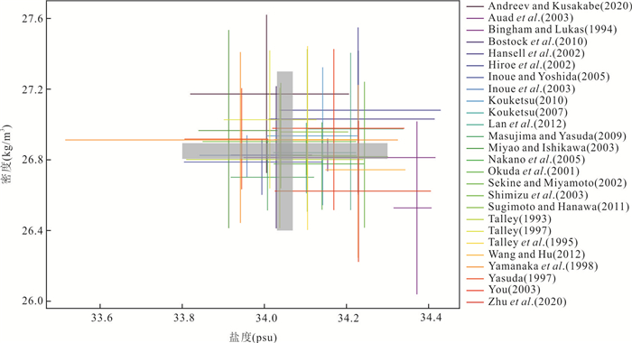
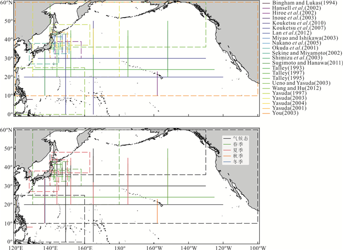
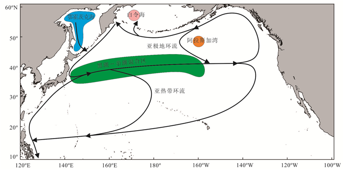
North Pacific Intermediate Water (NPIW) is the largest water mass that originates in the North Pacific Ocean, and the process of NPIW formation acts as the only channel that links surface and the deep water in the North Pacific. Within the atmosphere-ocean coupled system, vertical mixture and ventilation process associated with NPIW circulation plays critical roles in changing marine carbon cycle and marine ecosystem, thus important to understand the global warming and its future projection. Physical oceanographic studies of NPIW have been performed mainly since the 1970s. Most of existing studies about NPIW rely on cruise section and CTD data, in combination of numerical simulation. In this work, we provide a review about the studies about the modern NPIW to constrain the problems and prospects: To characterize a tendency and variability across Seasonal, interannual and decadal time scales in the modern NPIW; To explore physics of NPIW in response to atmosphere and upper ocean processes; To explore stability of NPIW and its feedback to the global warming.
North Pacific Intermediate Water (NPIW) is the largest water mass that originates in the North Pacific Ocean, and the process of NPIW formation acts as the only channel that links surface and the deep water in the North Pacific. Within the atmosphere-ocean coupled system, vertical mixture and ventilation process associated with NPIW circulation plays critical roles in changing marine carbon cycle and marine ecosystem, thus important to understand the global warming and its future projection. Physical oceanographic studies of NPIW have been performed mainly since the 1970s. Most of existing studies about NPIW rely on cruise section and CTD data, in combination of numerical simulation. In this work, we provide a review about the studies about the modern NPIW to constrain the problems and prospects: To characterize a tendency and variability across Seasonal, interannual and decadal time scales in the modern NPIW; To explore physics of NPIW in response to atmosphere and upper ocean processes; To explore stability of NPIW and its feedback to the global warming.
2024, 49(8): 2925-2937.
doi: 10.3799/dqkx.2023.070
Abstract:
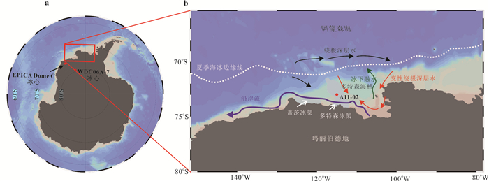
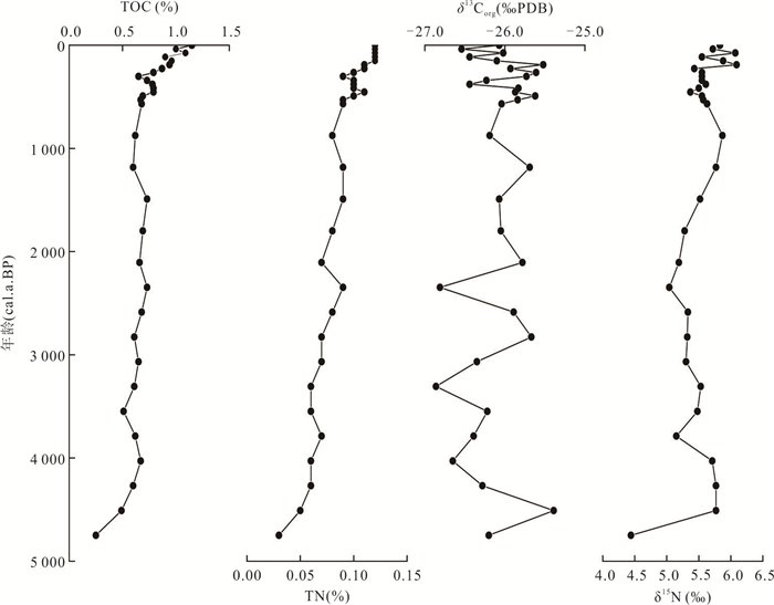
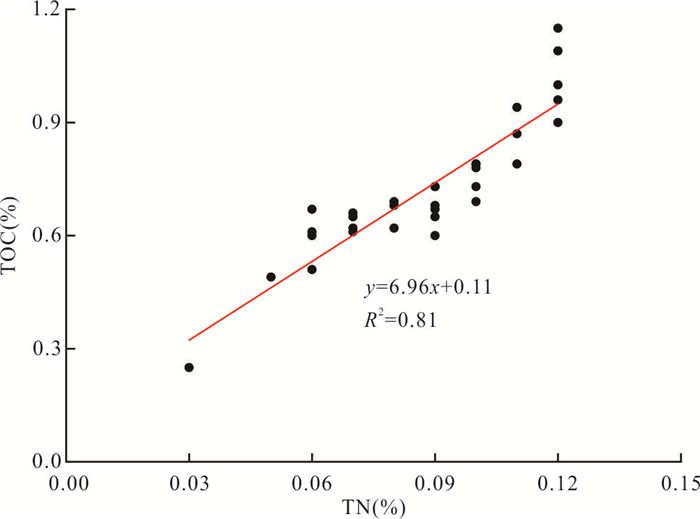
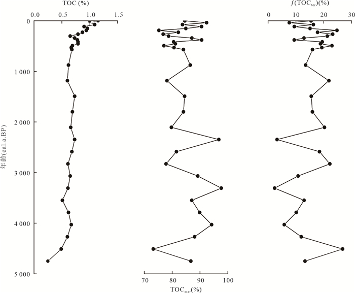
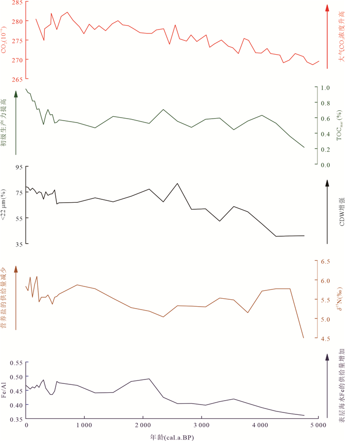
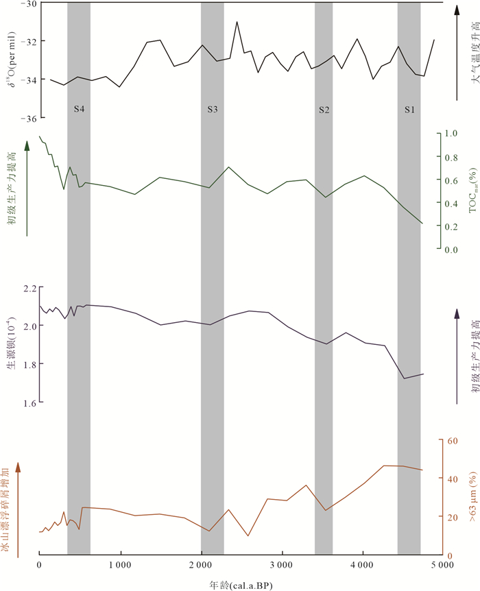
To better understand the current evolution of the Antarctic ice sheet and climate, as well as to provide a basis fo future predictions of ice sheet and climate change, the organic carbon and nitrogen contents and stable isotope values of sediments from Hole A11-02 were analyzed, combined with the characteristics of grain size and geochemical elements, to explore the origin and paleoclimatic significance of organic matter in sediments from the Amundsen Sea, West Antarctic since the mid-Holocene. The δ13Corg value of the sediments indicates that the organic matter is mainly input from marine, and the contribution of terrestrial organic matter is relatively small. By analyzing the changes of sediment total organic carbon content and sea source organic matter content, combined with the variation characteristics of grain size and elements, it is believed that the change of paleoproductivity in the study area since the mid-Holocene is mainly related to climate change, and then it is identified that there are four cold stages at 4 750-4 500 a BP, 3 600-3 400 a BP, 2 250-2 000 a BP and 600-400 a BP.
To better understand the current evolution of the Antarctic ice sheet and climate, as well as to provide a basis fo future predictions of ice sheet and climate change, the organic carbon and nitrogen contents and stable isotope values of sediments from Hole A11-02 were analyzed, combined with the characteristics of grain size and geochemical elements, to explore the origin and paleoclimatic significance of organic matter in sediments from the Amundsen Sea, West Antarctic since the mid-Holocene. The δ13Corg value of the sediments indicates that the organic matter is mainly input from marine, and the contribution of terrestrial organic matter is relatively small. By analyzing the changes of sediment total organic carbon content and sea source organic matter content, combined with the variation characteristics of grain size and elements, it is believed that the change of paleoproductivity in the study area since the mid-Holocene is mainly related to climate change, and then it is identified that there are four cold stages at 4 750-4 500 a BP, 3 600-3 400 a BP, 2 250-2 000 a BP and 600-400 a BP.
2024, 49(8): 2938-2951.
doi: 10.3799/dqkx.2023.045
Abstract:
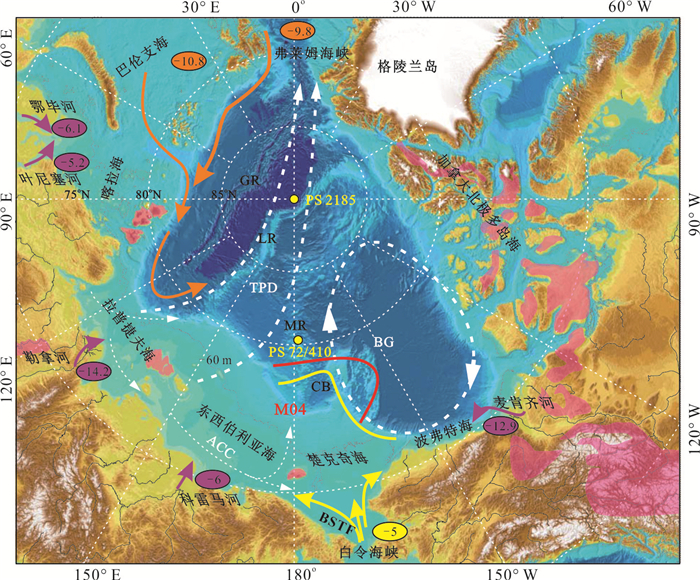
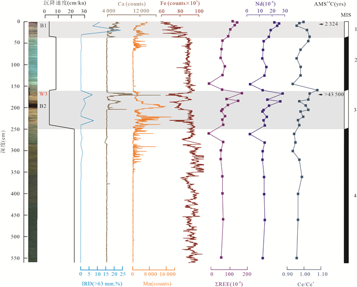
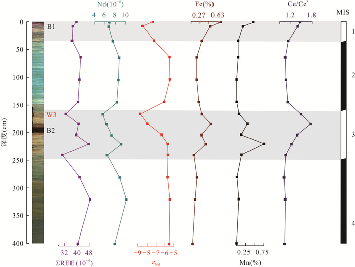
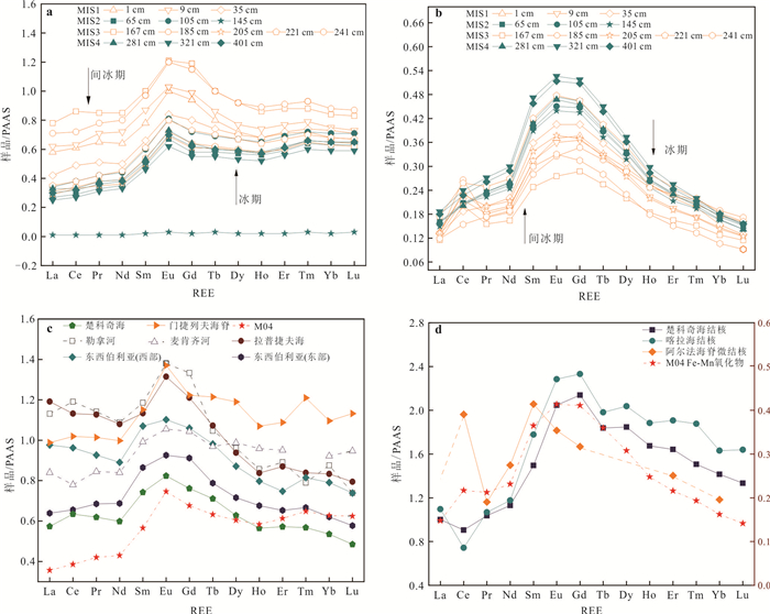
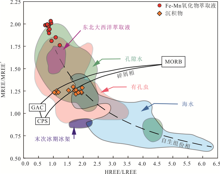
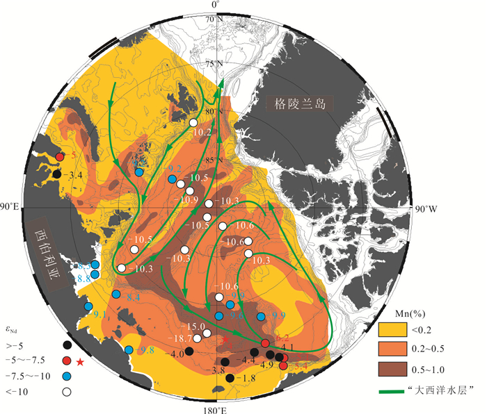
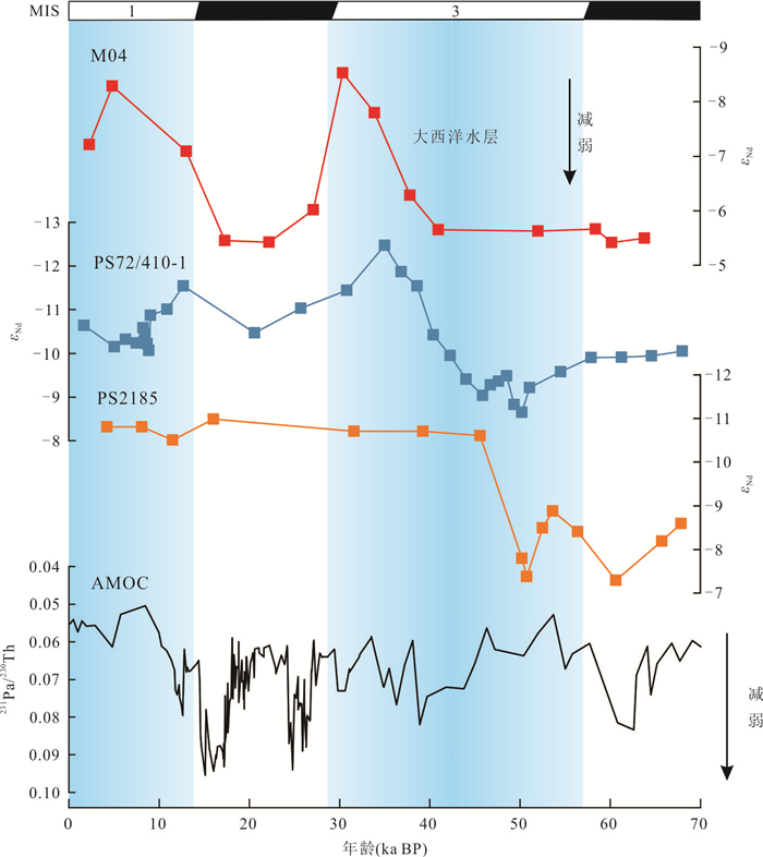
In the Arctic Ocean, the Atlantic water layer is an essential source of heat that regulates sea ice, ice shelves, and surrounding ice sheets. By analyzing the content and pattern of rare earth elements (REE) and Nd isotopic composition (εNd) in the sediments of Hole M04 and its distribution pattern and Nd isotopic composition of Fe-Mn oxide fraction, this study explores the enrichment mechanism of REE on the edge of Chukchi shelf since Late Pleistocene, the effectiveness of εNd tracer water mass properties, and the strength and weakness of the "Atlantic water layer".The records indicate that Fe-Mn oxides were the primary carriers for dissolved REE during the interglacial period, but a large quantity of dissolved REE was also enriched in the gray layer lacking Fe-Mn oxides. In addition, there is a significant spike of εNd in Fe-Mn oxide leachate during the glacial period and a drop during the interglacial period corresponding to values between -5.50 and -8.74. Therefore, we conclude that the Atlantic water layer strengthened during the interglacial period, which allowed re-oxidation of Fe2+ and Mn2+ input from the shelf, but withdrew almost entirely from the Chukchi continental margin during the glacial period. Similar to the chemical composition of modern glacial meltwater, the development of the East Siberian ice sheet and its subglacial drainage are more likely to lead to the REE enrichment and εNd positive bias in Core M04 Fe-Mn oxide extraction solution than sea ice production brine. These findings further illustrate the process of enrichment of REEs in the Arctic Ocean, demonstrate the effectiveness of εNd as a marker of the Atlantic water layer, and contribute to an understanding of the Atlantic water layer evolution.
In the Arctic Ocean, the Atlantic water layer is an essential source of heat that regulates sea ice, ice shelves, and surrounding ice sheets. By analyzing the content and pattern of rare earth elements (REE) and Nd isotopic composition (εNd) in the sediments of Hole M04 and its distribution pattern and Nd isotopic composition of Fe-Mn oxide fraction, this study explores the enrichment mechanism of REE on the edge of Chukchi shelf since Late Pleistocene, the effectiveness of εNd tracer water mass properties, and the strength and weakness of the "Atlantic water layer".The records indicate that Fe-Mn oxides were the primary carriers for dissolved REE during the interglacial period, but a large quantity of dissolved REE was also enriched in the gray layer lacking Fe-Mn oxides. In addition, there is a significant spike of εNd in Fe-Mn oxide leachate during the glacial period and a drop during the interglacial period corresponding to values between -5.50 and -8.74. Therefore, we conclude that the Atlantic water layer strengthened during the interglacial period, which allowed re-oxidation of Fe2+ and Mn2+ input from the shelf, but withdrew almost entirely from the Chukchi continental margin during the glacial period. Similar to the chemical composition of modern glacial meltwater, the development of the East Siberian ice sheet and its subglacial drainage are more likely to lead to the REE enrichment and εNd positive bias in Core M04 Fe-Mn oxide extraction solution than sea ice production brine. These findings further illustrate the process of enrichment of REEs in the Arctic Ocean, demonstrate the effectiveness of εNd as a marker of the Atlantic water layer, and contribute to an understanding of the Atlantic water layer evolution.
2024, 49(8): 2952-2960.
doi: 10.3799/dqkx.2023.144
Abstract:
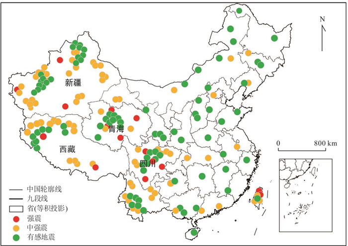
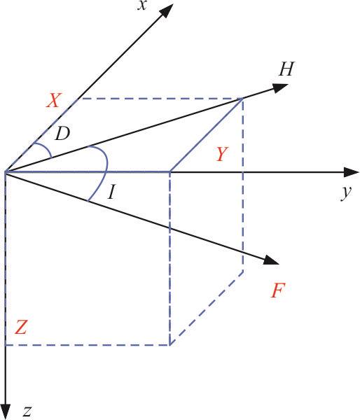
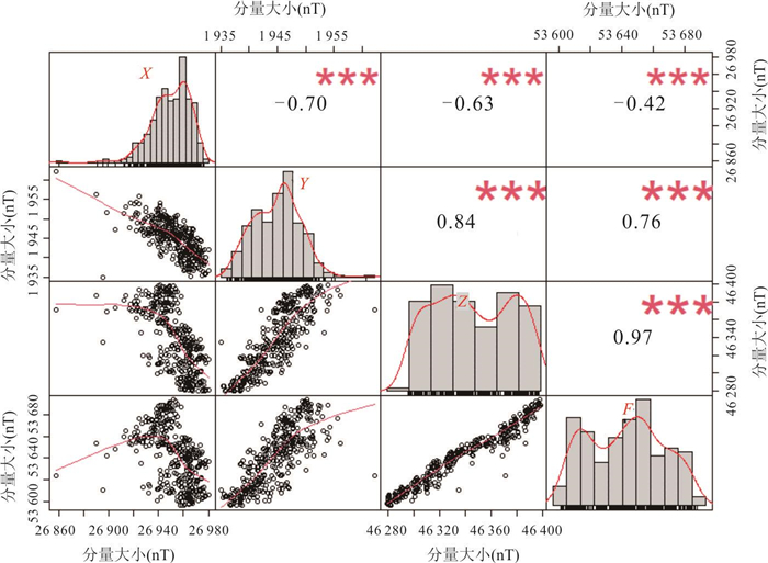
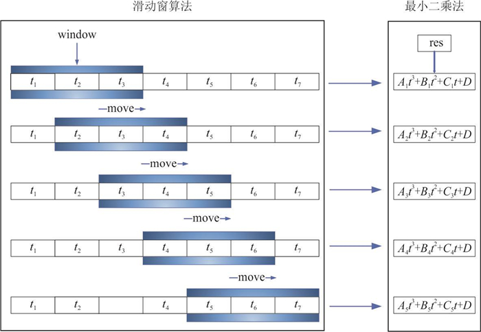
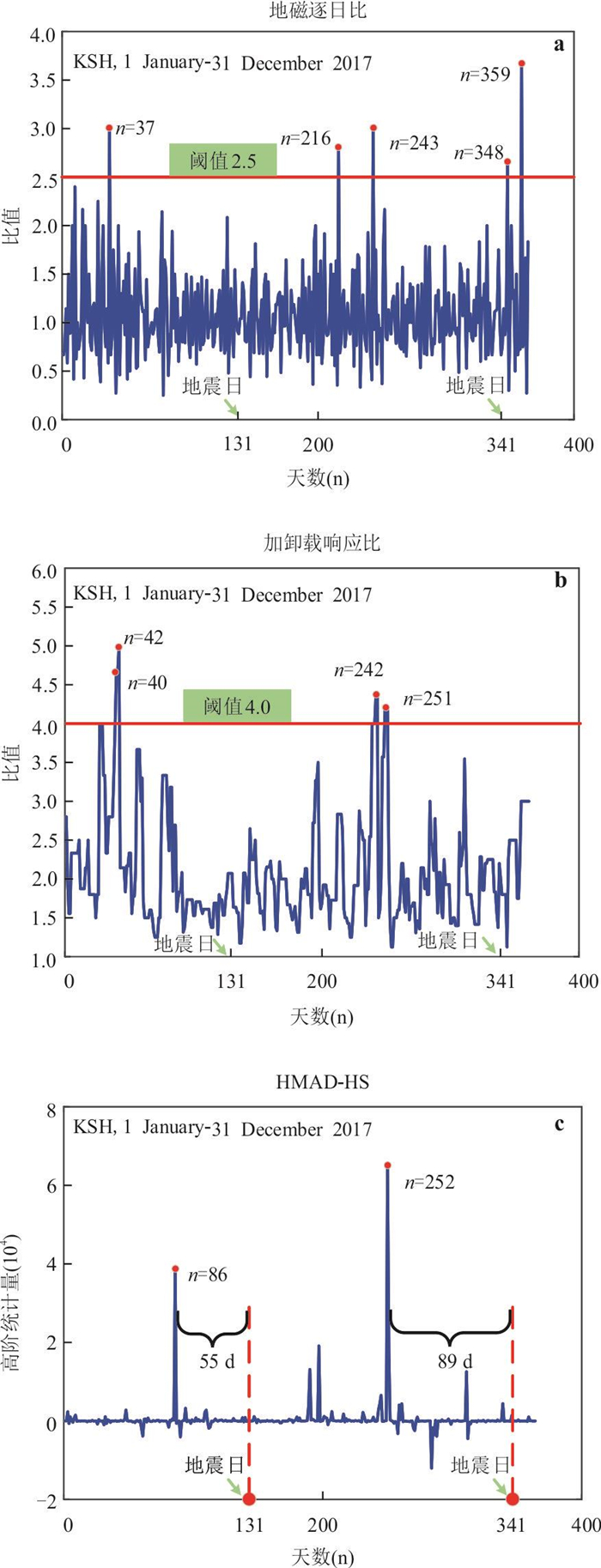
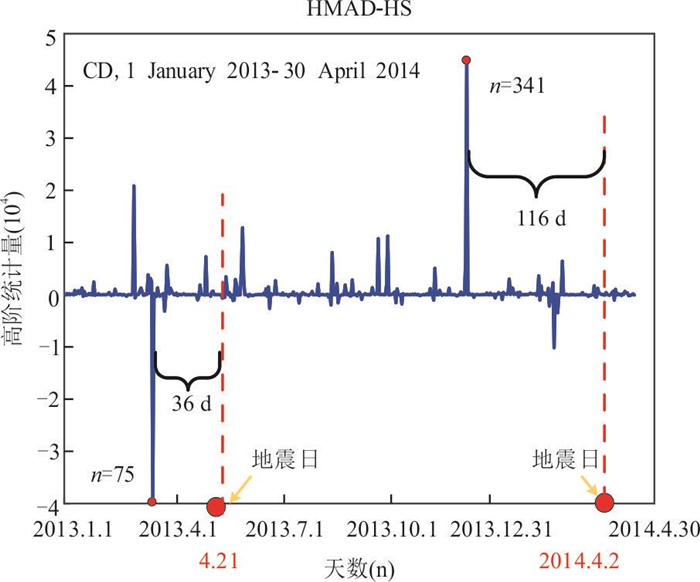
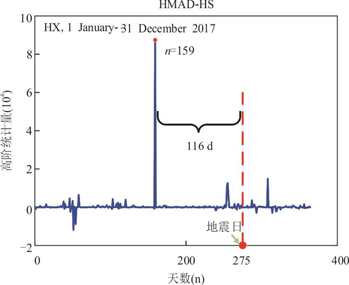
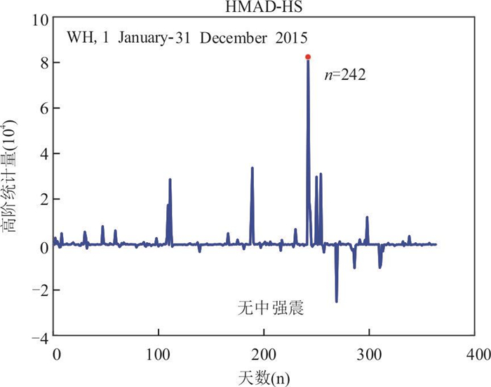
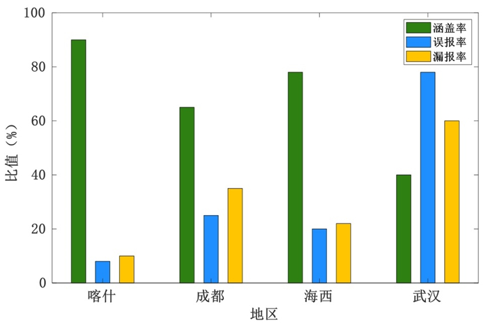
In recent years, moderate-strong earthquakes have brought indelible disasters to the safety of people's lives and properties. Hence, exploring the connection between geomagnetic fields and earthquakes, obtaining precursor information, and then realizing the prediction of moderate-strong earthquakes are vital issues that need to be solved urgently. For now, the vertical component Z of the geomagnetic field has been widely used for moderate-strong earthquake early warning. However, it still has numerous problems such as long prediction periods, difficulty in determining the threshold, and low prediction accuracy. To solve the above problems, a short-impending earthquake prediction method based on high-order magnetic anomaly derivative and high-order statistic, dubbed HMAD-HS, is proposed, which can effectively reduce the influence of Gaussian noise on the precursor geomagnetic field, shorten the prediction period, and then improve the prediction accuracy. To verify the feasibility of this method, taking the moderate-strong earthquakes of Kashgar, Xinjiang in 2017 as an example, the HMAD-HS was compared with two commonly used methods, i.e., load-unload response ratio and geomagnetic daily ratio. The experimental results show that the precursor signals of moderate-strong earthquakes obtained by HMAD-HS are obvious, and the missing report rate and false report rate are reduced by more than 30%, which greatly improves the forecast credibility. Further, the applications of HMAD-HS for the short-term prediction of moderate-strong earthquakes in many regions of our country prove that the proposed method is universal and has a good effect on predicting moderate-strong earthquakes.
In recent years, moderate-strong earthquakes have brought indelible disasters to the safety of people's lives and properties. Hence, exploring the connection between geomagnetic fields and earthquakes, obtaining precursor information, and then realizing the prediction of moderate-strong earthquakes are vital issues that need to be solved urgently. For now, the vertical component Z of the geomagnetic field has been widely used for moderate-strong earthquake early warning. However, it still has numerous problems such as long prediction periods, difficulty in determining the threshold, and low prediction accuracy. To solve the above problems, a short-impending earthquake prediction method based on high-order magnetic anomaly derivative and high-order statistic, dubbed HMAD-HS, is proposed, which can effectively reduce the influence of Gaussian noise on the precursor geomagnetic field, shorten the prediction period, and then improve the prediction accuracy. To verify the feasibility of this method, taking the moderate-strong earthquakes of Kashgar, Xinjiang in 2017 as an example, the HMAD-HS was compared with two commonly used methods, i.e., load-unload response ratio and geomagnetic daily ratio. The experimental results show that the precursor signals of moderate-strong earthquakes obtained by HMAD-HS are obvious, and the missing report rate and false report rate are reduced by more than 30%, which greatly improves the forecast credibility. Further, the applications of HMAD-HS for the short-term prediction of moderate-strong earthquakes in many regions of our country prove that the proposed method is universal and has a good effect on predicting moderate-strong earthquakes.
2024, 49(8): 2961-2978.
doi: 10.3799/dqkx.2024.015
Abstract:
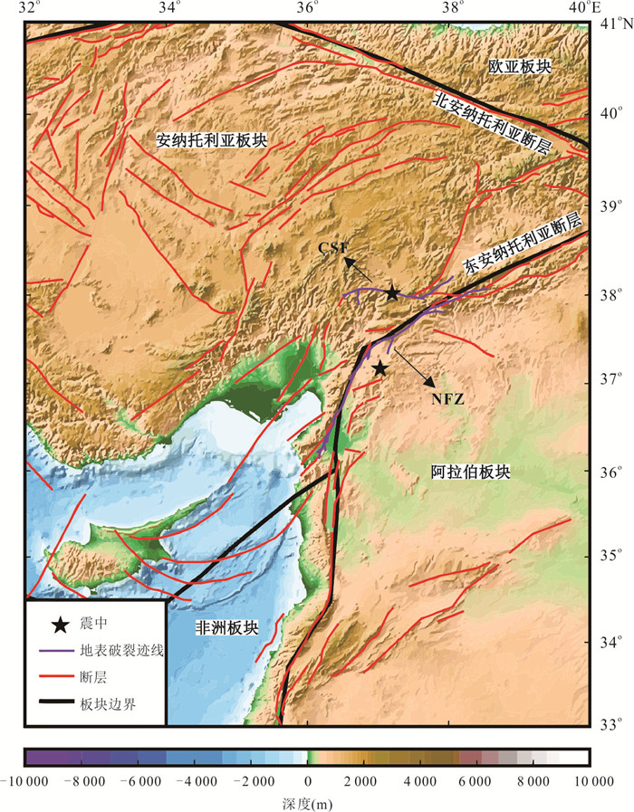
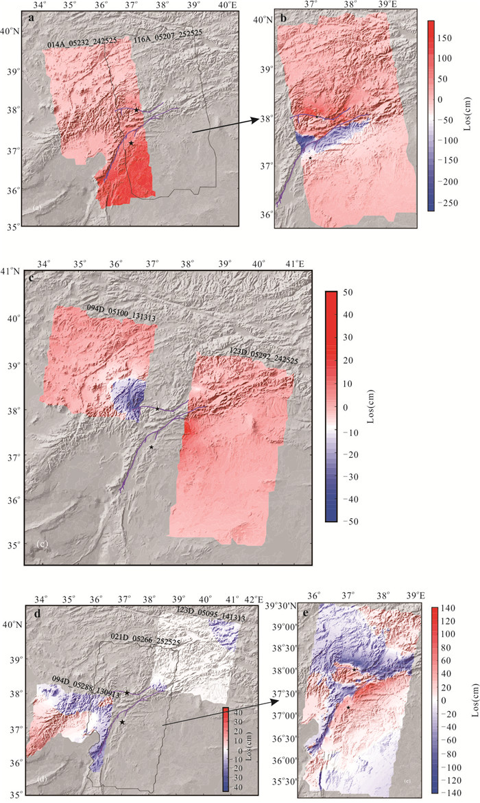
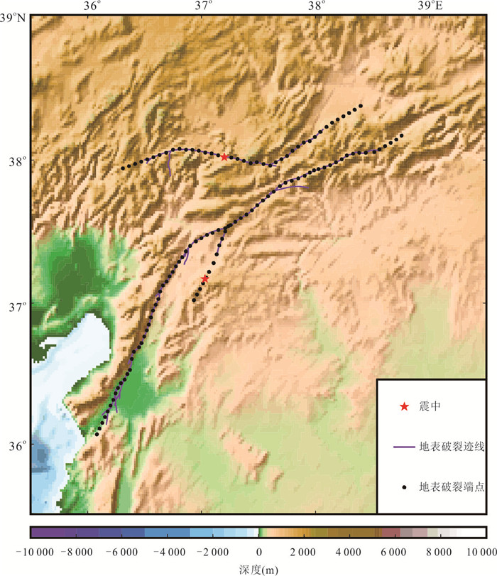
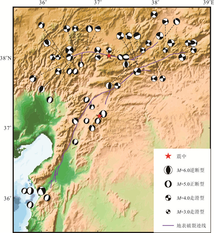
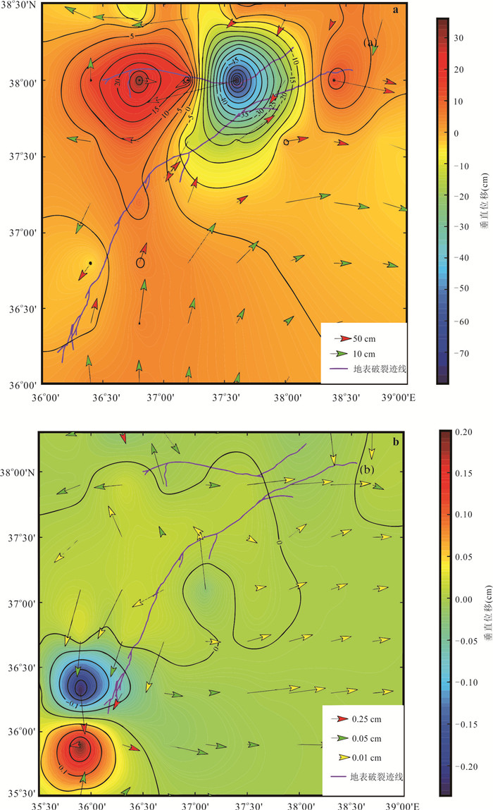
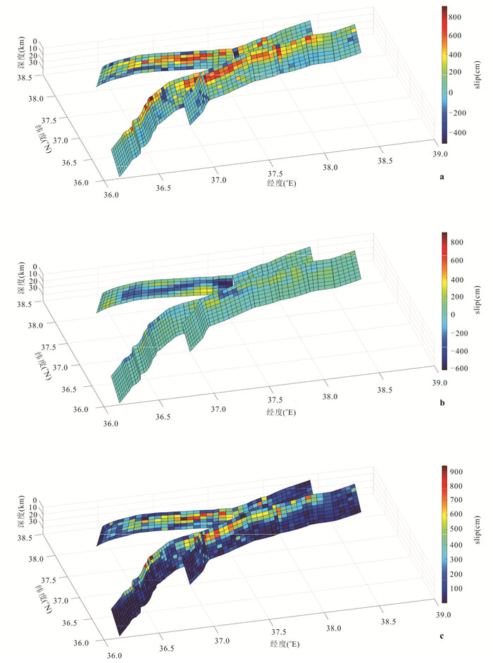
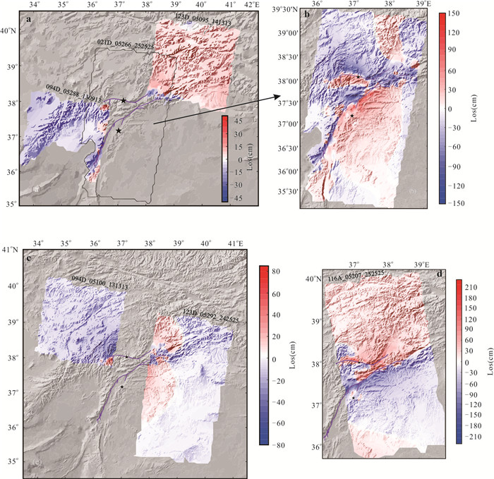
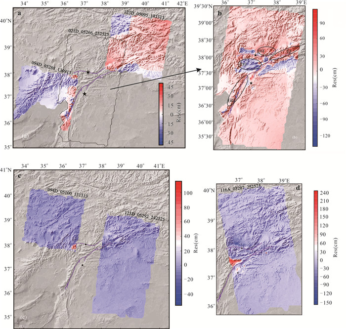
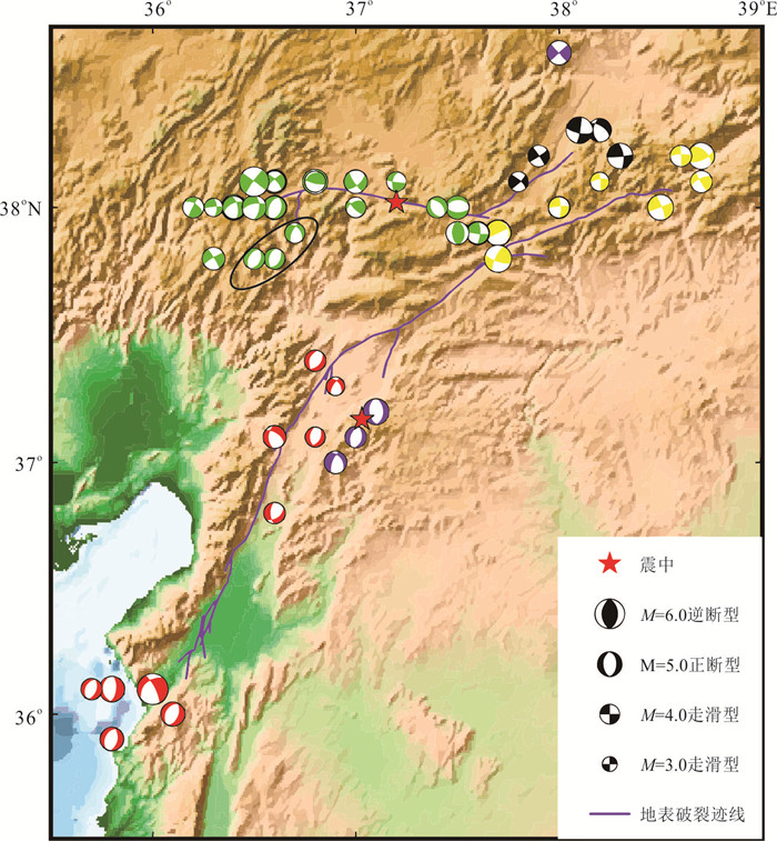
Two destructive earthquake with magnitude greater than 7.0 occurred in Türkiye on February 6, 2023. So far, there are still large differences in the seismic rupture models of Türkiye obtained with different observations. Among them, the finite fault model given by United States Geological Survey is the most accurate comprehensive model available at present. Therefore, by adopting the finite fault model from the USGS as the prior model, we invert thecoseismic rupture distribution of twins strong earthquakes inTürkiye, by using the InSAR observation data from Sentinel-1. Our results reveal that: (1) The total seismic moment obtained from the inversion is 1.626 8 × 10²¹ N∙m, which is equivalent to a large earthquake with a magnitude of Mw8.1; (2) The rupture on the East Anatolian Main fault is mainly concentrated in the range of 0-15 km underground and the rupture on the Çardak-Sürgü Fault zone, but the rupture in the northern branch fault of East Anatolian fault is mostly focused in the depth range of 5-20 km. In the East Anatolian Main fault, the rupture presents two obvious high-value zones. One located at the intersection of the Narlıdağ Fault Zone and the East Anatolian Main Fault, and the other located approximately 65 km southwest of the intersection of the Narlıdağ Fault Zone and the East Anatolian Main Fault. The maximum strike-slip component of the rupture can reach 9.0 m and the maximum dip-slip component is approximately 3.0 m. In the Çardak-Sürgü Fault, the general pattern also shows two high-value zones, one located near the epicenter of the earthquake of magnitude 7.5 in Türkiye and one at the intersection of the southeast-northwest-trending and northeast-southwest-trending faults in the northwest corner of the Çardak-Sürgü Fault. The maximum value of the strike-slip component is approximately 8.1 m and the maximum value of the dip-slip component is approximately 6.1 m. The rupture produced by the twin earthquake in Türkiye is dominated by the strike-slip component and supplemented by the dip-slip component. Furthermore, the twin seismogenic faults, the East Anatolian Main fault and Çardak-Sürgü Fault zone, are both generally sinistral slip in nature. However, it alsoshows there are some thrust slip and normal slip in nature on a local scale.
Two destructive earthquake with magnitude greater than 7.0 occurred in Türkiye on February 6, 2023. So far, there are still large differences in the seismic rupture models of Türkiye obtained with different observations. Among them, the finite fault model given by United States Geological Survey is the most accurate comprehensive model available at present. Therefore, by adopting the finite fault model from the USGS as the prior model, we invert thecoseismic rupture distribution of twins strong earthquakes inTürkiye, by using the InSAR observation data from Sentinel-1. Our results reveal that: (1) The total seismic moment obtained from the inversion is 1.626 8 × 10²¹ N∙m, which is equivalent to a large earthquake with a magnitude of Mw8.1; (2) The rupture on the East Anatolian Main fault is mainly concentrated in the range of 0-15 km underground and the rupture on the Çardak-Sürgü Fault zone, but the rupture in the northern branch fault of East Anatolian fault is mostly focused in the depth range of 5-20 km. In the East Anatolian Main fault, the rupture presents two obvious high-value zones. One located at the intersection of the Narlıdağ Fault Zone and the East Anatolian Main Fault, and the other located approximately 65 km southwest of the intersection of the Narlıdağ Fault Zone and the East Anatolian Main Fault. The maximum strike-slip component of the rupture can reach 9.0 m and the maximum dip-slip component is approximately 3.0 m. In the Çardak-Sürgü Fault, the general pattern also shows two high-value zones, one located near the epicenter of the earthquake of magnitude 7.5 in Türkiye and one at the intersection of the southeast-northwest-trending and northeast-southwest-trending faults in the northwest corner of the Çardak-Sürgü Fault. The maximum value of the strike-slip component is approximately 8.1 m and the maximum value of the dip-slip component is approximately 6.1 m. The rupture produced by the twin earthquake in Türkiye is dominated by the strike-slip component and supplemented by the dip-slip component. Furthermore, the twin seismogenic faults, the East Anatolian Main fault and Çardak-Sürgü Fault zone, are both generally sinistral slip in nature. However, it alsoshows there are some thrust slip and normal slip in nature on a local scale.
2024, 49(8): 2979-2991.
doi: 10.3799/dqkx.2023.053
Abstract:
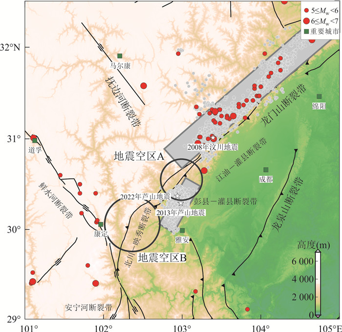
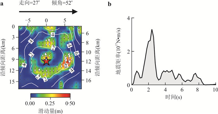
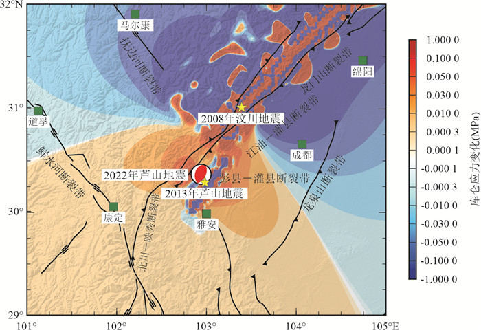
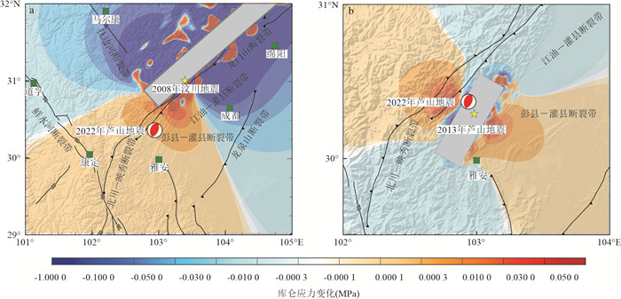
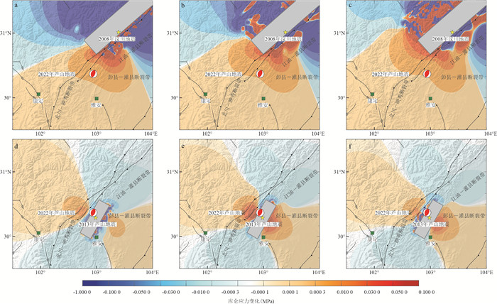
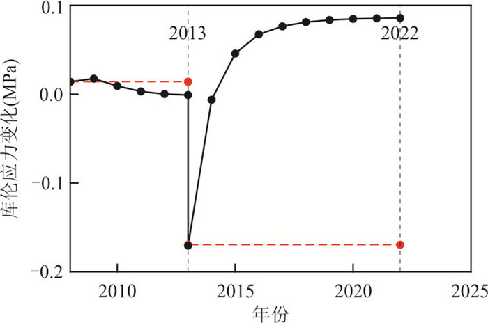
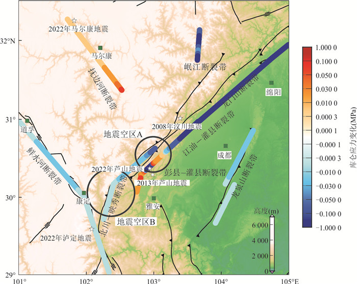
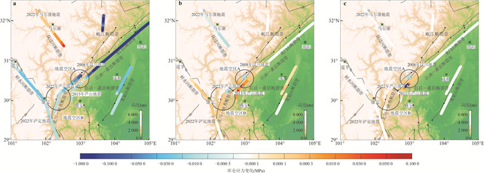
On June 1, 2022, an earthquake of magnitude 6.1 occurred in Lushan, Sichuan, causing 4 deaths, 14 injuries and economic losses in many surrounding counties. This region is characterized by a dense fault system and intense historical earthquakes, as well as a seismic gap that receives much attention, so a retrospective study of major historical earthquake sequences and their impacts on seismic risks in the region is of great significance for seismic hazard mitigations in the future. Based on the elastic dislocation theory and the regional lithosphere layered model, this paper calculates the co-seismic and post-earthquake viscoelastic relaxation effects of the Mw7.9 Wenchuan earthquake and the Ms7.0 Lushan earthquake on the epicenter of the 2022 earthquake at different depths, and discusses the impacts of historical earthquakes on the occurrence of this earthquake. Moreover, stress accumulation on active faults in the area and surrounding areas in the next ten years is calculated to delineate areas with high seismic risk in the future. The results show that: (1) The Mw7.9 Wenchuan earthquake resulted in a stress increment of 0.014 MPa at the epicenter of the 2022 Ms6.1 Lushan earthquake, which may have effectively promoted the occurrence of this earthquake, while the Ms7.0 Lushan earthquake caused a stress release of 0.174 MPa, which delays the occurrence of the 2022 earthquake. Considering the influence of viscoelastic relaxation after the 2008 and 2013 earthquakes, stress increment of the epicenter is 0.086 MPa, which has already recovered to a higher stress level before its occurrence. (2) The Coulomb stress increment in the middle section of the Dayi seismic gap and the Fubianhe fault zone will further increase in the future, and so doesthe seismic risk.
On June 1, 2022, an earthquake of magnitude 6.1 occurred in Lushan, Sichuan, causing 4 deaths, 14 injuries and economic losses in many surrounding counties. This region is characterized by a dense fault system and intense historical earthquakes, as well as a seismic gap that receives much attention, so a retrospective study of major historical earthquake sequences and their impacts on seismic risks in the region is of great significance for seismic hazard mitigations in the future. Based on the elastic dislocation theory and the regional lithosphere layered model, this paper calculates the co-seismic and post-earthquake viscoelastic relaxation effects of the Mw7.9 Wenchuan earthquake and the Ms7.0 Lushan earthquake on the epicenter of the 2022 earthquake at different depths, and discusses the impacts of historical earthquakes on the occurrence of this earthquake. Moreover, stress accumulation on active faults in the area and surrounding areas in the next ten years is calculated to delineate areas with high seismic risk in the future. The results show that: (1) The Mw7.9 Wenchuan earthquake resulted in a stress increment of 0.014 MPa at the epicenter of the 2022 Ms6.1 Lushan earthquake, which may have effectively promoted the occurrence of this earthquake, while the Ms7.0 Lushan earthquake caused a stress release of 0.174 MPa, which delays the occurrence of the 2022 earthquake. Considering the influence of viscoelastic relaxation after the 2008 and 2013 earthquakes, stress increment of the epicenter is 0.086 MPa, which has already recovered to a higher stress level before its occurrence. (2) The Coulomb stress increment in the middle section of the Dayi seismic gap and the Fubianhe fault zone will further increase in the future, and so doesthe seismic risk.

2024, 49(8): 2992-3009.
doi: 10.3799/dqkx.2023.041
Abstract:
The Ediacaran Dengying Formation inthe Yangtze Gorges area contains many well-preserved macrofossils, one of the most intensively studied Ediacaran units before the Cambrian Explosion. The Dengying Formation in the Yangtze Gorges area canbe generally subdivided into three lithostratigraphic members. However, the thickness and lithology of the Dengying Formation at different locations around the HuanglingAnticline are different. The stratigraphic correlation of the Dengying Formation in the Yangtze Gorges area needs further study. In this paper, a comparative study was carried out around the HuanglingAnticline in western Hubei Province. The stratigraphic sequence of the Dengying Formation is proposed to be categorized into seven types based on lithostratigraphic features. Moreover, the relationship between each lithostratigraphic unit in the Denying Formation is summarized. Consequently, the research will bebeneficialto the regional correlation of the Dengying Formation, and help unveil environmental and biotic evolutions in the late Ediacaran period.
The Ediacaran Dengying Formation inthe Yangtze Gorges area contains many well-preserved macrofossils, one of the most intensively studied Ediacaran units before the Cambrian Explosion. The Dengying Formation in the Yangtze Gorges area canbe generally subdivided into three lithostratigraphic members. However, the thickness and lithology of the Dengying Formation at different locations around the HuanglingAnticline are different. The stratigraphic correlation of the Dengying Formation in the Yangtze Gorges area needs further study. In this paper, a comparative study was carried out around the HuanglingAnticline in western Hubei Province. The stratigraphic sequence of the Dengying Formation is proposed to be categorized into seven types based on lithostratigraphic features. Moreover, the relationship between each lithostratigraphic unit in the Denying Formation is summarized. Consequently, the research will bebeneficialto the regional correlation of the Dengying Formation, and help unveil environmental and biotic evolutions in the late Ediacaran period.
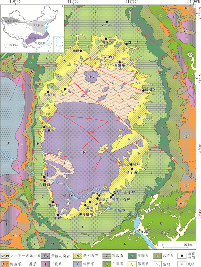

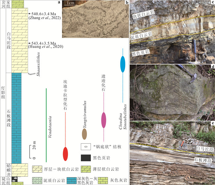
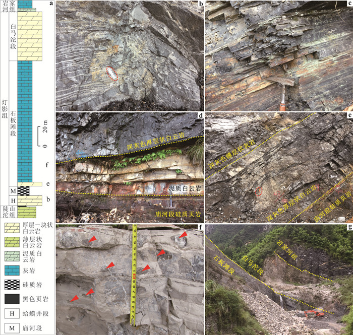
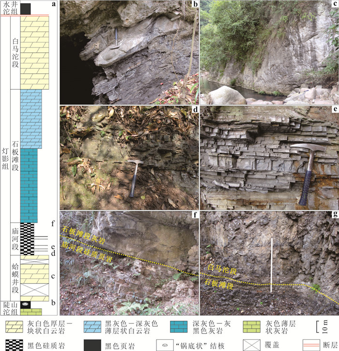
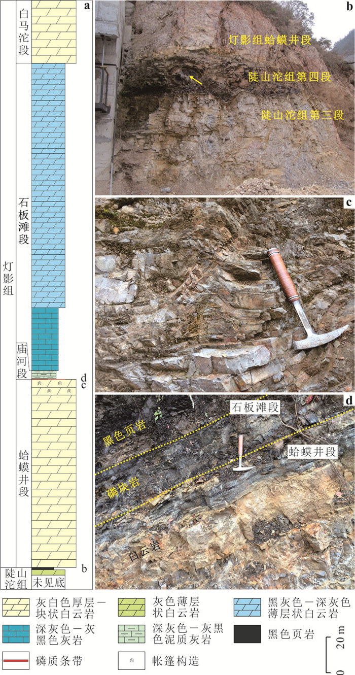
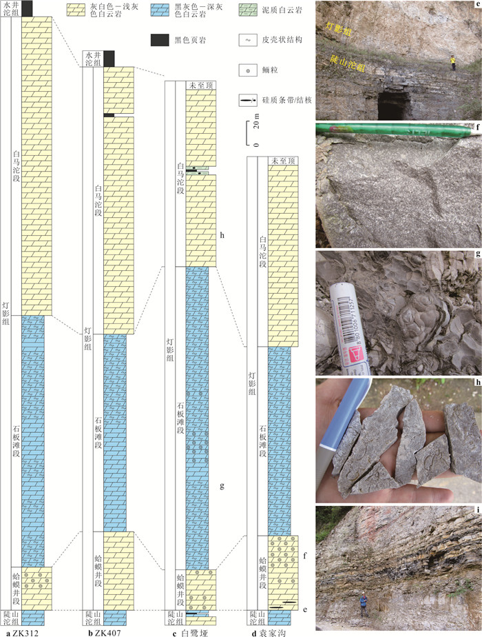
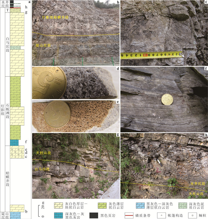
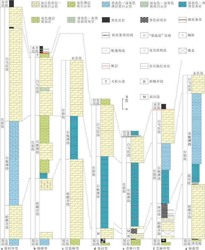
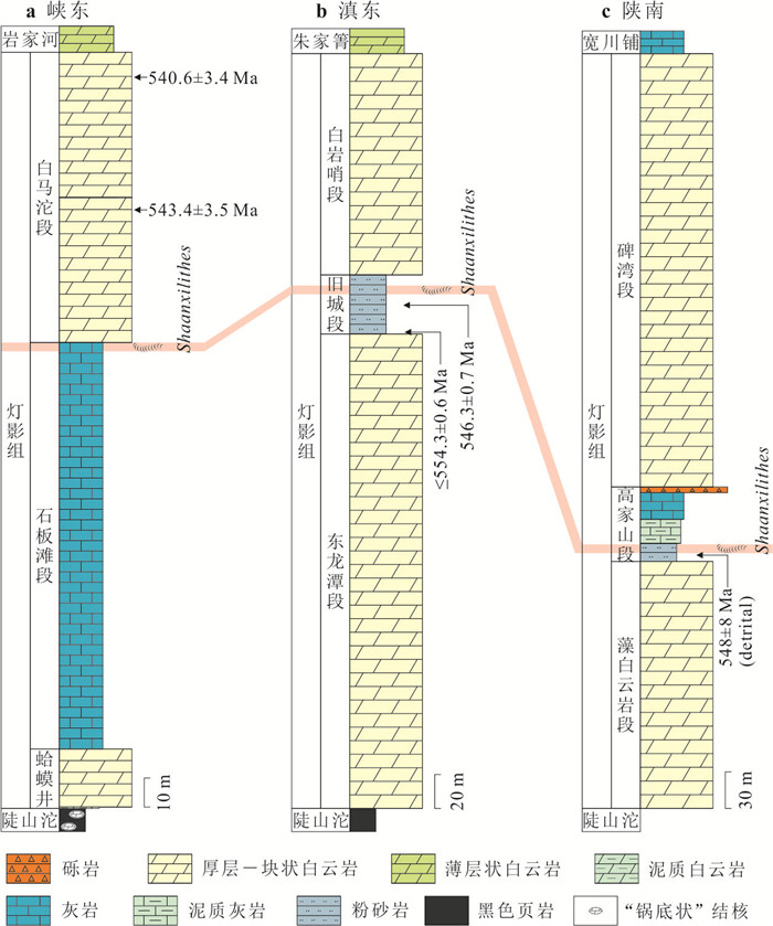
2024, 49(8): 3010-3019.
doi: 10.3799/dqkx.2022.482
Abstract:
Under climate change, glacier movement controls mass transport changes, which further leads to the response of changes in glacier length, area and thickness. However, there are differences on response time and degree for glaciers in different scales and types. For further understanding the mechanism of heterogeneous glacier changes, the spatial and temporal characteristics of glacier movement in the High Mountain Asia were analyzed by using ITS_LIVE glacier velocity data. And the influencing factors of glacier movement, glacier velocity change were analysed by Geodetector and correlation analysis. The results are as follows: The characteristic values of glacier movement are larger in the southeastern Tibetan Plateau and the Hindu Kush, but smaller in the West Kunlun, the eastern Tianshan and the eastern Tibetan Plateau. Most glaciers in the High Mountain Asia were slowing down during 2000-2016. Glaciers in Hengduan and Nianqentanglha Mountains decelerate most dramatically. In contrast, West Kunlun experience slightly accelerated glacier movement. Glacier movement is mainly controlled by glacier length and area (thickness), as well as terrain and climate factors. The change of glacier mass balance or thickness is the most important reason for glacier movement change.
Under climate change, glacier movement controls mass transport changes, which further leads to the response of changes in glacier length, area and thickness. However, there are differences on response time and degree for glaciers in different scales and types. For further understanding the mechanism of heterogeneous glacier changes, the spatial and temporal characteristics of glacier movement in the High Mountain Asia were analyzed by using ITS_LIVE glacier velocity data. And the influencing factors of glacier movement, glacier velocity change were analysed by Geodetector and correlation analysis. The results are as follows: The characteristic values of glacier movement are larger in the southeastern Tibetan Plateau and the Hindu Kush, but smaller in the West Kunlun, the eastern Tianshan and the eastern Tibetan Plateau. Most glaciers in the High Mountain Asia were slowing down during 2000-2016. Glaciers in Hengduan and Nianqentanglha Mountains decelerate most dramatically. In contrast, West Kunlun experience slightly accelerated glacier movement. Glacier movement is mainly controlled by glacier length and area (thickness), as well as terrain and climate factors. The change of glacier mass balance or thickness is the most important reason for glacier movement change.
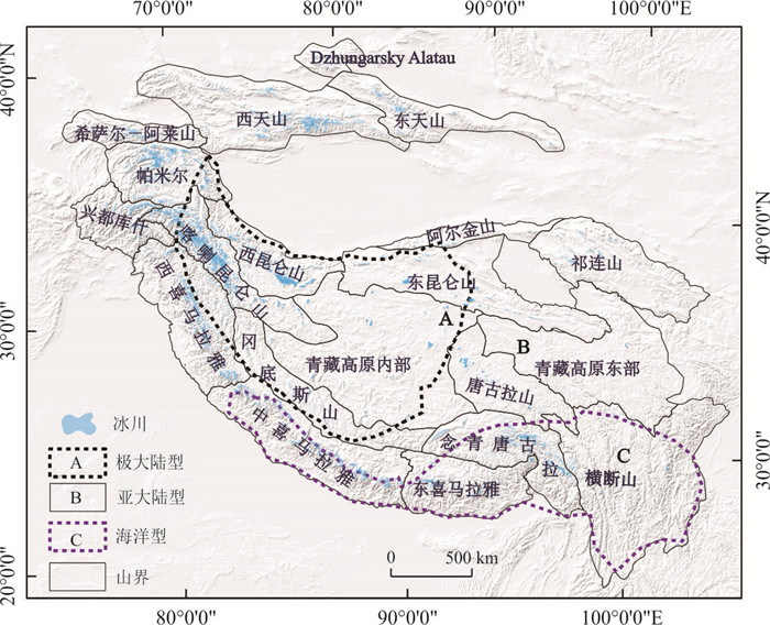
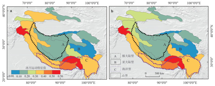
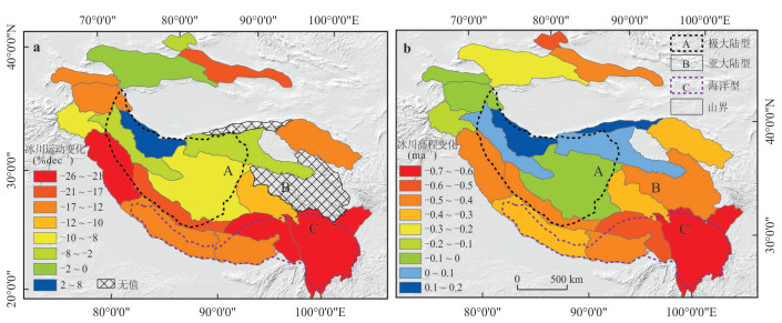
2024, 49(8): 3020-3028.
doi: 10.3799/dqkx.2022.408
Abstract:
With the acceleration of the infrastructure construction of national urban agglomeration, the demand for the current situation of urban road network data has increased sharply. Aiming at the instability of the current road network matching algorithm with location and length as the main parameters, as well as the uncertainty and poor reliability of the analysis results, a new road network matching model based on fuzzy hierarchy theory is proposed. The model is constructed by integrating multiple evaluation indexes, and the index weight is optimized. The model is used to evaluate the consistency of the road network. The road network of Changsha Zhuzhou Xiangtan Urban Agglomeration is taken as the experimental object for experimental verification. The experimental results show that the matching model proposed in this paper can effectively improve the matching accuracy of road network, and has good stability and reliability. The accuracy and recall of road matching have reached 92.9% and 86.2% respectively, which is significantly higher than 86.7% and 83.8% of the existing typical matching methods. The research results provide a new and more effective method for road network matching and evaluation.
With the acceleration of the infrastructure construction of national urban agglomeration, the demand for the current situation of urban road network data has increased sharply. Aiming at the instability of the current road network matching algorithm with location and length as the main parameters, as well as the uncertainty and poor reliability of the analysis results, a new road network matching model based on fuzzy hierarchy theory is proposed. The model is constructed by integrating multiple evaluation indexes, and the index weight is optimized. The model is used to evaluate the consistency of the road network. The road network of Changsha Zhuzhou Xiangtan Urban Agglomeration is taken as the experimental object for experimental verification. The experimental results show that the matching model proposed in this paper can effectively improve the matching accuracy of road network, and has good stability and reliability. The accuracy and recall of road matching have reached 92.9% and 86.2% respectively, which is significantly higher than 86.7% and 83.8% of the existing typical matching methods. The research results provide a new and more effective method for road network matching and evaluation.
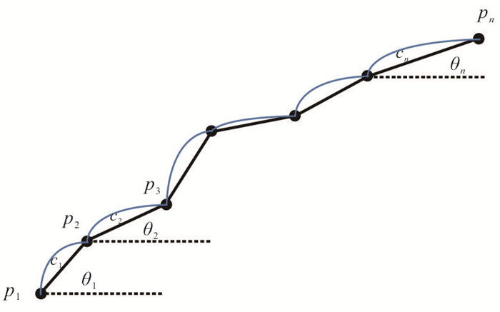
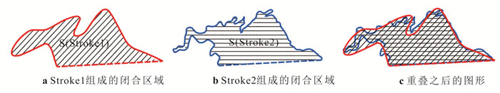
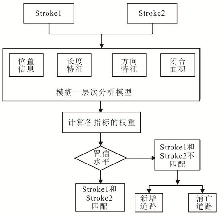
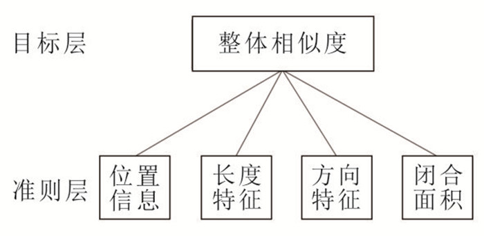
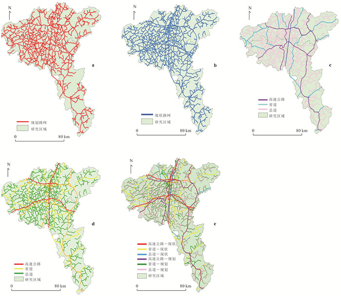
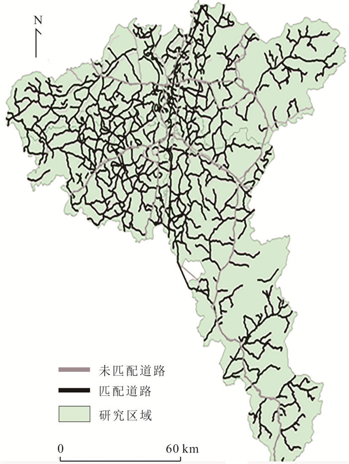
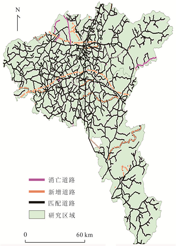
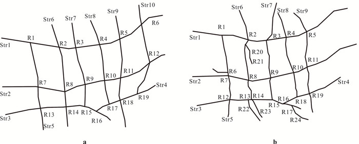
2024, 49(8): 3029-3042.
doi: 10.3799/dqkx.2022.391
Abstract:
The western and eastern zones of the Kuqa Depression show clear contrasts in geomorphology, structural belt width, and structural styles.In this study, we use physical analog modeling to explain the structural differences between the eastern and western zones of the Qiongdongnan Basin with the main variables being the strength of the gypsum rocks and basement. The model results show that the differences between the rheological strength of silicone and the basement have a great influence on the kinematic characteristics of the evolution process, and the structural styles are also different in different strength zones. By comparing the structural characteristics of Kuqa Depression with the structural pattern developed in analog models, it is considered that the differences in the viscosity of the gypsum-salt rocks and Paleozoic basement strength between the eastern and western zones of Kuqa Depression are the important factors for the segmentation of Kuqa Depression. The viscosity of gypsum rock layer has a strong controlling on the structure style above the gypsum-salt rocks, which affects the propagation range and structure styles.The structural styles under the gypsum-salt rocks closely related to the basement strength.The basement with weak strength inhibits the propagation of the structure under the gypsum-salt rocks. Thus, both the structural styles above and under the gypsum-salt rocks of Kuqa depression show the segmentations.
The western and eastern zones of the Kuqa Depression show clear contrasts in geomorphology, structural belt width, and structural styles.In this study, we use physical analog modeling to explain the structural differences between the eastern and western zones of the Qiongdongnan Basin with the main variables being the strength of the gypsum rocks and basement. The model results show that the differences between the rheological strength of silicone and the basement have a great influence on the kinematic characteristics of the evolution process, and the structural styles are also different in different strength zones. By comparing the structural characteristics of Kuqa Depression with the structural pattern developed in analog models, it is considered that the differences in the viscosity of the gypsum-salt rocks and Paleozoic basement strength between the eastern and western zones of Kuqa Depression are the important factors for the segmentation of Kuqa Depression. The viscosity of gypsum rock layer has a strong controlling on the structure style above the gypsum-salt rocks, which affects the propagation range and structure styles.The structural styles under the gypsum-salt rocks closely related to the basement strength.The basement with weak strength inhibits the propagation of the structure under the gypsum-salt rocks. Thus, both the structural styles above and under the gypsum-salt rocks of Kuqa depression show the segmentations.
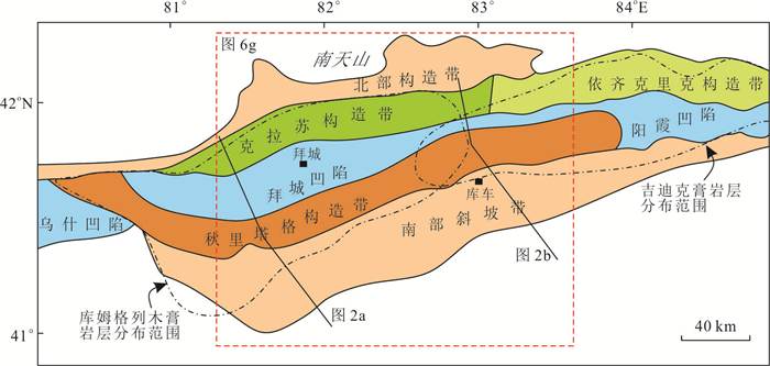
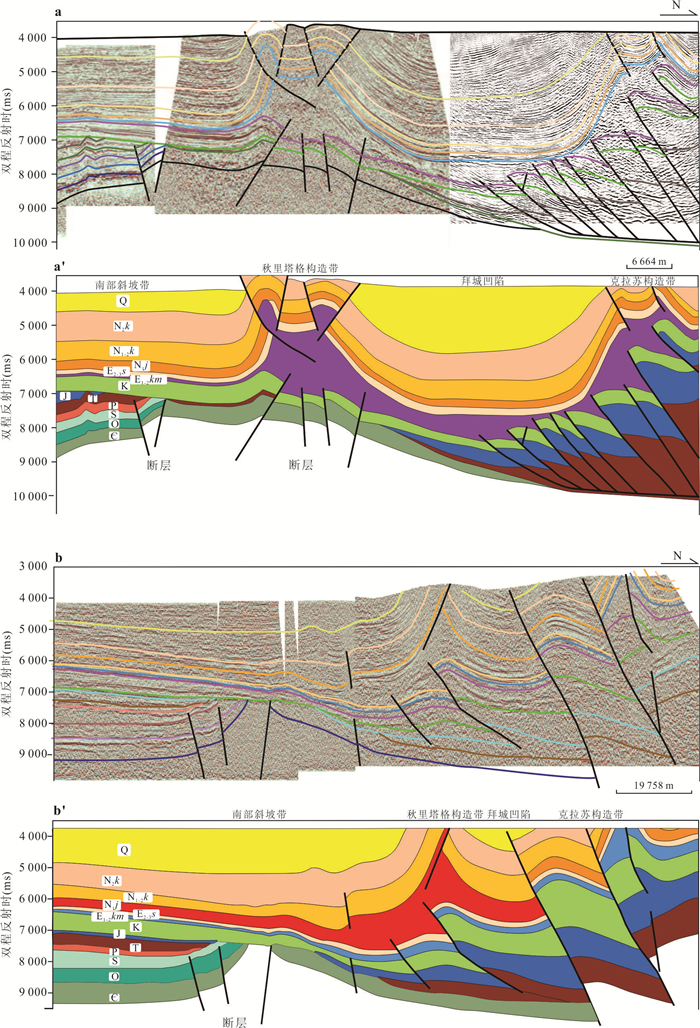
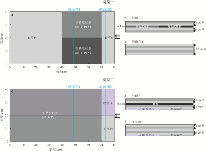
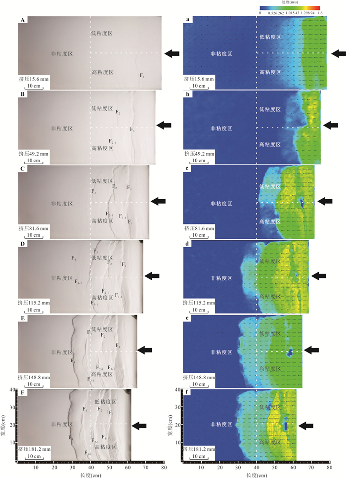
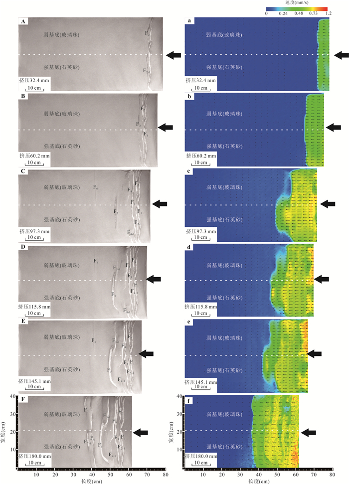
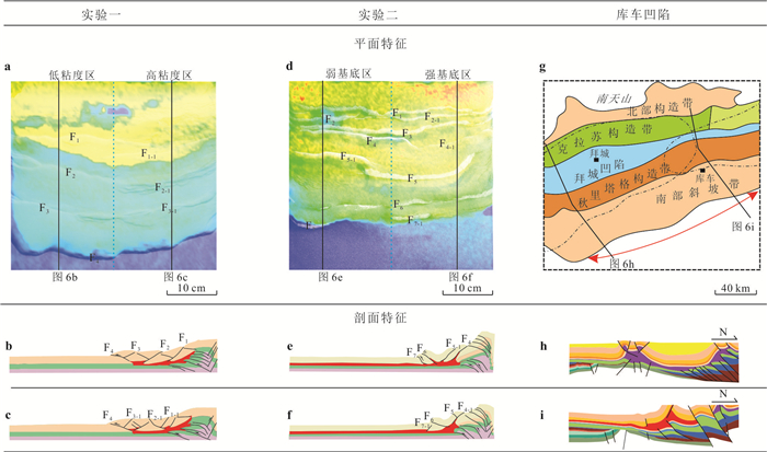
2024, 49(8): 3043-3055.
doi: 10.3799/dqkx.2023.067
Abstract:
The Late Pleistocene tectonic activities of Hainan Island appear various vertical movements and results in a series of river terraces developed in the island. The evolution of these terraces can reveal the characteristics of differential structural activities in different areas of Hainan Island. The optically stimulated luminescence (OSL) dating is used to date the river terraces of 6 rivers in the western Hainan Island. Based on a detailed field geological survey and geomorphology researches, the chronological framework of river terraces (27.3-29.6 ka, 2.82-3.92 ka, 0.60-0.93 ka, ~0.40-0.50 ka) are set up. Combined with the tectonic activity and regional climate evolution around Hainan Island, the origin of those river terraces is discussed. The results show that T4 would be mainly caused by the climate changes. Climate changes altered runoff carrying capacity and sediment flux, leading to accumulation and erosion of these rivers. T3, T2 and T1 terraces would be controlled by multiple faults and the key factor for the development of terraces would be the intermittent differential tectonic uplift movement. The difference of river incision rate indicates that the rate of tectonic uplift rate in its mid-western area is higher than those of southwester area during 0.60-3.92 ka.
The Late Pleistocene tectonic activities of Hainan Island appear various vertical movements and results in a series of river terraces developed in the island. The evolution of these terraces can reveal the characteristics of differential structural activities in different areas of Hainan Island. The optically stimulated luminescence (OSL) dating is used to date the river terraces of 6 rivers in the western Hainan Island. Based on a detailed field geological survey and geomorphology researches, the chronological framework of river terraces (27.3-29.6 ka, 2.82-3.92 ka, 0.60-0.93 ka, ~0.40-0.50 ka) are set up. Combined with the tectonic activity and regional climate evolution around Hainan Island, the origin of those river terraces is discussed. The results show that T4 would be mainly caused by the climate changes. Climate changes altered runoff carrying capacity and sediment flux, leading to accumulation and erosion of these rivers. T3, T2 and T1 terraces would be controlled by multiple faults and the key factor for the development of terraces would be the intermittent differential tectonic uplift movement. The difference of river incision rate indicates that the rate of tectonic uplift rate in its mid-western area is higher than those of southwester area during 0.60-3.92 ka.
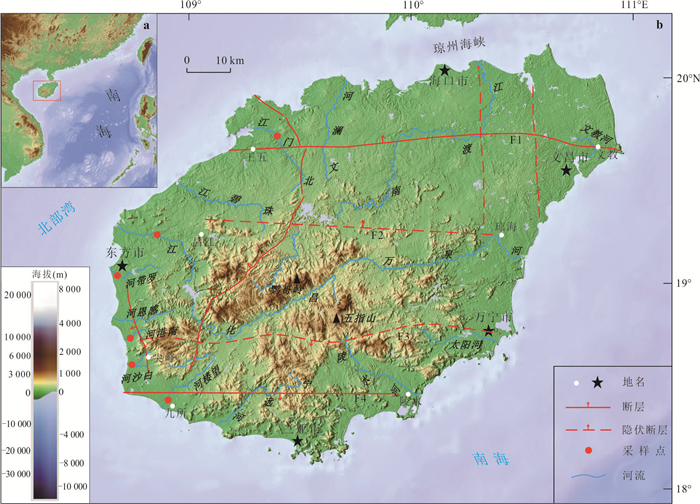
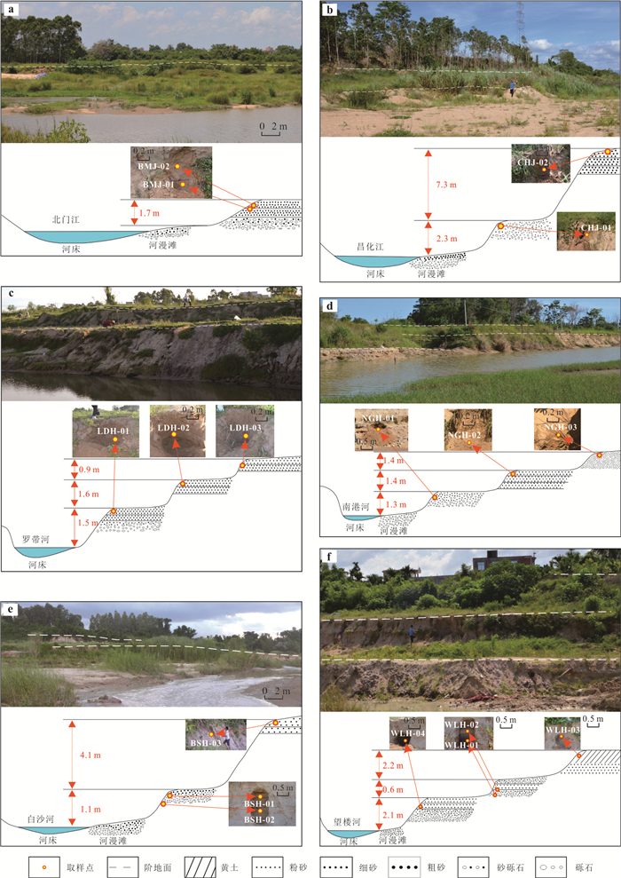
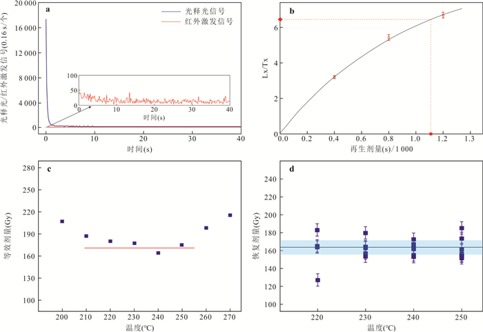
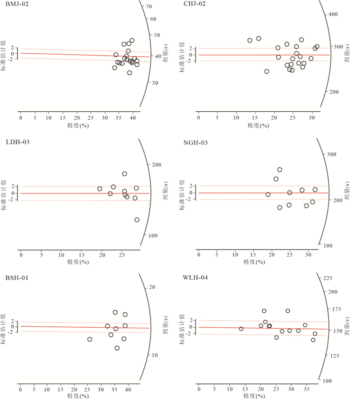
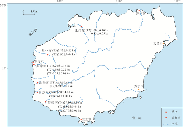
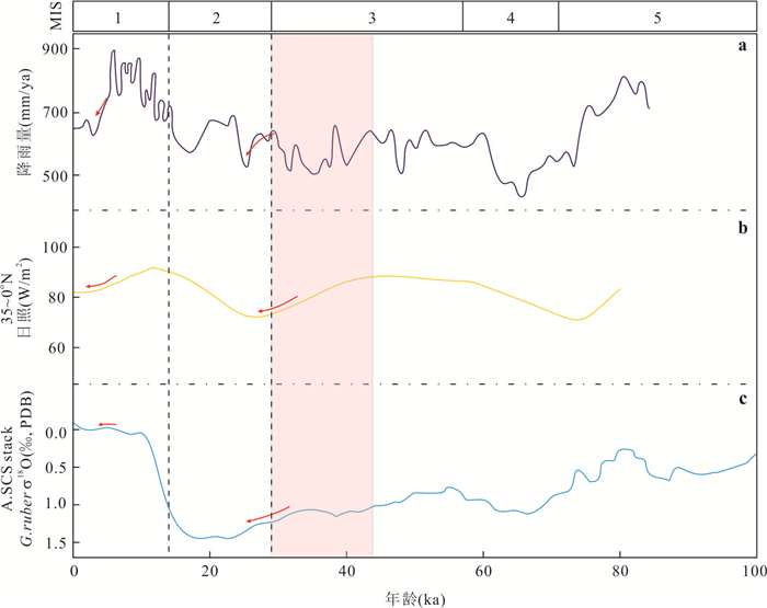
2024, 49(8): 3056-3070.
doi: 10.3799/dqkx.2023.069
Abstract:
To fully utilize known knowledge to reduce uncertainty of three-dimensional (3D) geological model, a Bayesian-Markov chain Monte Carlo (Bayesian-MCMC) based 3D geological model inference framework is proposed to consider the uncertainty of modeling data (prior parameter) and integrate known knowledge or geophysical exploration data as likelihood function into the process of 3D geological implicit modeling by Cokriging interpolant, which well satisfies the known knowledge. Firstly, different prior distributions of modeling data and likelihood functions of known knowledge are built based on Bayesian probabilistic theory. Secondly, the posterior space of prior parameter (modeling data) can be explored by Markov chain Monte Carlo (MCMC) sampling method to obtain a large number of samples which simultaneously satisfy the prior distributions of modeling data and likelihood constraints of know knowledge. Thirdly, a series of 3D geological model realizations satisfying known knowledge can be constructed by Cokriging interpolant using above newly obtained samples of modeling data. Finally, compared with the deterministic 3D geological modeling methods, the Bayesian-MCMC probabilistic inference framework can obtain a series of model realizations to allowably apply information entropy to evaluate model uncertainty. Taking the Lingnian-Nacha area in the southwestern Guangxi Zhuang Autonomous Region (GZAR) of China as am example, the proposed Bayesian-MCMC probabilistic inference framework was used to optimize 3D geological model simultaneously considering location and attitude uncertainties of strata and fault and known knowledge of stratum thickness and attitudes of strata and fault. The results of case study show that the proposed method can not only reconstruct 3D spatial geometry of geological body but also reduce uncertainty of 3D geological model, which provides geologist with an effective way to integrate modeling data and known knowledge to reconstruct 3D geological model and reduce its uncertainty.
To fully utilize known knowledge to reduce uncertainty of three-dimensional (3D) geological model, a Bayesian-Markov chain Monte Carlo (Bayesian-MCMC) based 3D geological model inference framework is proposed to consider the uncertainty of modeling data (prior parameter) and integrate known knowledge or geophysical exploration data as likelihood function into the process of 3D geological implicit modeling by Cokriging interpolant, which well satisfies the known knowledge. Firstly, different prior distributions of modeling data and likelihood functions of known knowledge are built based on Bayesian probabilistic theory. Secondly, the posterior space of prior parameter (modeling data) can be explored by Markov chain Monte Carlo (MCMC) sampling method to obtain a large number of samples which simultaneously satisfy the prior distributions of modeling data and likelihood constraints of know knowledge. Thirdly, a series of 3D geological model realizations satisfying known knowledge can be constructed by Cokriging interpolant using above newly obtained samples of modeling data. Finally, compared with the deterministic 3D geological modeling methods, the Bayesian-MCMC probabilistic inference framework can obtain a series of model realizations to allowably apply information entropy to evaluate model uncertainty. Taking the Lingnian-Nacha area in the southwestern Guangxi Zhuang Autonomous Region (GZAR) of China as am example, the proposed Bayesian-MCMC probabilistic inference framework was used to optimize 3D geological model simultaneously considering location and attitude uncertainties of strata and fault and known knowledge of stratum thickness and attitudes of strata and fault. The results of case study show that the proposed method can not only reconstruct 3D spatial geometry of geological body but also reduce uncertainty of 3D geological model, which provides geologist with an effective way to integrate modeling data and known knowledge to reconstruct 3D geological model and reduce its uncertainty.